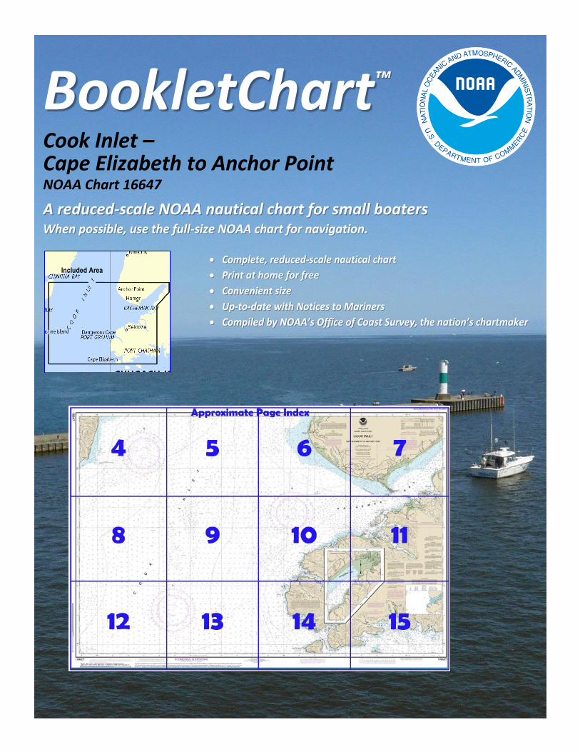
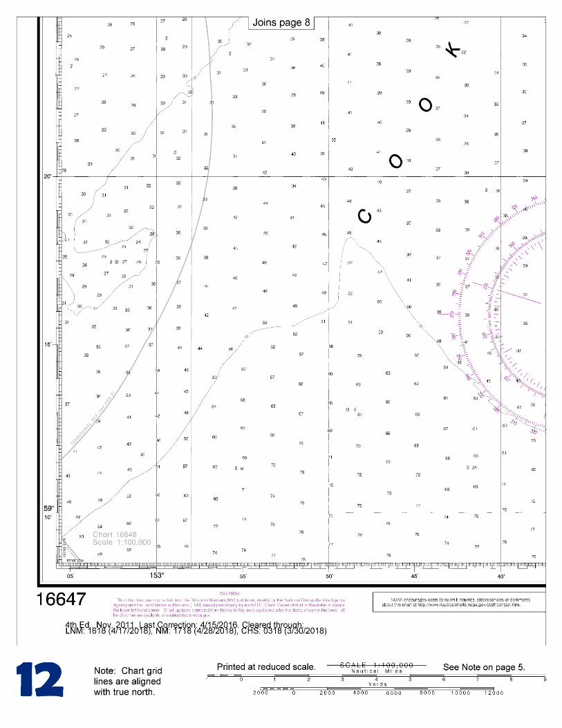
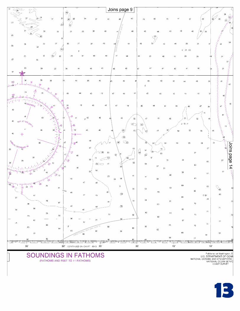
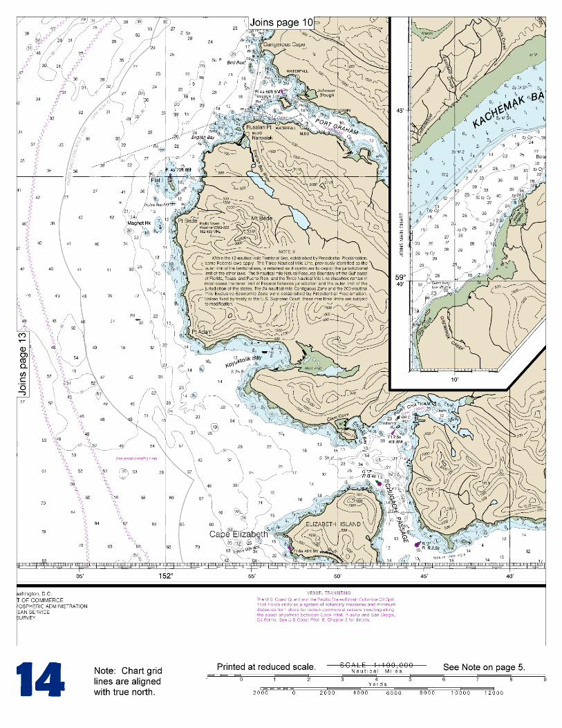
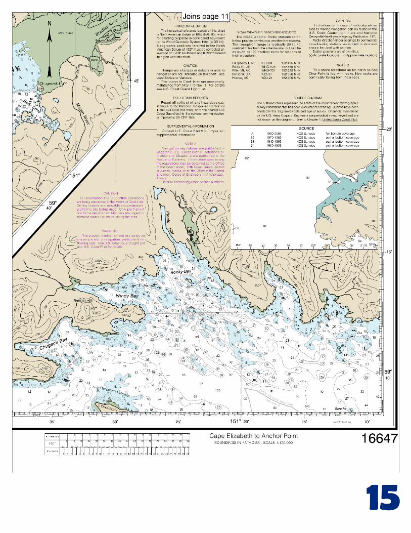
BookletChart ™ Cook Inlet – Cape Elizabeth to Anchor Point NOAA Chart 16647 A reduced-scale NOAA nautical chart for small boaters When possible, use the full-size NOAA chart for navigation. Included Area
Transcript
BookletChart™ Cook Inlet – Cape Elizabeth to Anchor Point NOAA Chart 16647
A reduced-scale NOAA nautical chart for small boaters When possible, use the full-size NOAA chart for navigation.
Included Area
2
Published by the National Oceanic and Atmospheric Administration
National Ocean Service Office of Coast Survey
www.NauticalCharts.NOAA.gov 888-990-NOAA
What are Nautical Charts?
Nautical charts are a fundamental tool of marine navigation. They show water depths, obstructions, buoys, other aids to navigation, and much more. The information is shown in a way that promotes safe and efficient navigation. Chart carriage is mandatory on the commercial ships that carry America’s commerce. They are also used on every Navy and Coast Guard ship, fishing and passenger vessels, and are widely carried by recreational boaters.
What is a BookletChart?
This BookletChart is made to help recreational boaters locate themselves on the water. It has been reduced in scale for convenience, but otherwise contains all the information of the full-scale nautical chart. The bar scales have also been reduced, and are accurate when used to measure distances in this BookletChart. See the Note at the bottom of page 5 for the reduction in scale applied to this chart.
Whenever possible, use the official, full scale NOAA nautical chart for navigation. Nautical chart sales agents are listed on the Internet at http://www.NauticalCharts.NOAA.gov.
This BookletChart does NOT fulfill chart carriage requirements for regulated commercial vessels under Titles 33 and 44 of the Code of Federal Regulations.
Notice to Mariners Correction Status
This BookletChart has been updated for chart corrections published in the U.S. Coast Guard Local Notice to Mariners, the National Geospatial Intelligence Agency Weekly Notice to Mariners, and, where applicable, the Canadian Coast Guard Notice to Mariners. Additional chart corrections have been made by NOAA in advance of their publication in a Notice to Mariners. The last Notices to Mariners applied to this chart are listed in the Note at the bottom of page 7. Coast Pilot excerpts are not being corrected.
For latest Coast Pilot excerpt visit the Office of Coast Survey website at http://www.nauticalcharts.noaa.gov/nsd/coastpilot_w.php?book=9.
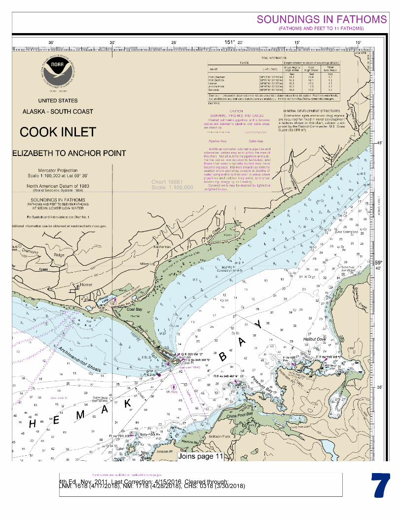
(Selected Excerpts from Coast Pilot) Chugach Passage is between Perl and Elizabeth Islands and the rounded end of the mainland. A lighted buoy marks the NE side of the S turn and SW side of the N turn in the passage channel, respectively. The end of the mainland is fringed with reefs, isolated rocks, and extensive kelp beds. In rounding it from the E, the outermost danger is a rock, bare at half tide, 0.4 mile off the S side of the rounding mainland shore.
Chugach Passage is commonly used by vessels entering Cook Inlet from E. Depths of 5½ to 10 fathoms were found in the shallowest part of the channel between the SE end of Elizabeth Island and the dangerous reefs that extend from the mainland. An abrupt rocky spot, covered
7 fathoms, is about 0.5 mile NW of the N end of Perl Island. Elizabeth Island has two mountain masses, separated by a low valley that extends in a NW direction. The NE point is a sandspit marked at its outer extremity by a buoy. A depth of 1½ fathoms is 0.3 mile SE and a prominent large bare rock is 0.3 mile WSW, respectively, from the buoy. Cape Elizabeth is the W end of the island. Cape Elizabeth Light (59°08'47"N., 151°52'36"W.), 48 feet (14.6 m) above the water, is shown from a skeleton tower with a diamond-shaped red and white daymark near the S end of the cape. A submerged rock, dangerous to navigation, is 0.4 mile W of the cape. Port Chatham, indenting the end of Kenai Peninsula N of Elizabeth Island, is a secure harbor for small and medium-sized vessels, and easily entered in the daytime with clear weather. Kachemak Bay is a large bay on the E side of Cook Inlet. The entrance is between Seldovia Point (59°28.3'N., 151°42.0'W.) on the S and Anchor Point (59°46.8'N., 151°52.0'W.) on the N. It affords excellent anchorage for vessels of all classes and sizes. Kachemak Bay is frequented by large vessels picking up or disembarking pilots; numerous commercial, charter, and recreational fishing vessels; tour boats; tugs with barges; an Alaska State Ferry; and occasional cruise ships. Caution.–Vessels transiting to and from Homer to the N are advised to stay 3 miles offshore from Bluff Point and 5 miles offshore from Anchor Point to clear the shoals and kelp, and most fishing vessel traffic and their fixed gear. From Homer Spit to Anchor Point the coast is a line of bluffs, with the greatest height of 750 feet at Bluff Point. In front of the bluff is a narrow rock and shingle beach. Numerous hazardous rocks are offshore between Homer and Anchor Point. The depths inside the 10-fathom curve are irregular, and there is a possibility of detached boulders not found by the survey. Vessels transiting to and from Homer to the N are advised to stay 3 miles offshore from Bluff Point and 5 miles offshore from Anchor Point to clear the shoals and kelp, and most fishing vessel traffic and their fixed gear. Anchor Point Light (59°46'09"N., 151°52'01"W.), 41 feet (12.5 m) above the water, is shown from a skeleton tower with a diamond-shaped red and white daymark on the point. Anchor Point is an important transit turn point, and is a “Securite” Broadcast reporting point used by large vessels. (See Securite Broadcasts, indexed as such, earlier this chapter for more.) Note: The vicinity of Anchor Point has some of the heavier winds and higher seas on the Homer to Anchorage transit. Caution: Tide rips with steep, short choppy seas have been reported 3 to 5 miles S of Gore Point, especially on an ebb current with either a strong W or SE wind. The neck joining the headland at Gore Point to the mainland is low and wooded. On the W side of the neck is a cove affording indifferent anchorage with E winds. The S point of the cove is the W end of the headland, and is a shelving ridge of bare rock. Close to this point is a rocky islet, from which rocks, bare at low water, and kelp extend about 200 yards NW. A rock, covered at high water, is about 100 yards from the cliff at the SE end of the cove. A large kelp area extends about 200 yards NW from the rock. The anchorage is in 18 to 25 fathoms, soft bottom, 250 to 300 yards from the beach of the low neck and about 0.3 mile from the cliff on the S side. The water deepens rapidly NW, the swinging room is scant, and the anchorage is uneasy. It is recommended only as a temporary anchorage.
U.S. Coast Guard Rescue Coordination Center 24 hour Regional Contact for Emergencies
RCC Juneau Commander
17th CG District (907) 463-2000 Juneau, Alaska
G
NOAA’s navigation managers serve as ambassadors to the maritime community. They help identify navigational challenges facing professional and recreational mariners, and provide NOAA resources and information for safe navigation. For additional information, please visit nauticalcharts.noaa.gov/service/navmanagers
To make suggestions or ask questions online, go to nauticalcharts.noaa.gov/inquiry. To report a chart discrepancy, please use ocsdata.ncd.noaa.gov/idrs/discrepancy.aspx.
Lateral System As Seen Entering From Seaward on navigable waters except Western Rivers
PORT SIDE
ODD NUMBERED AIDS
GREEN LIGHT ONLY
FLASHING (2)
PREFERRED CHANNEL
NO NUMBERS – MAY BE LETTERED
PREFERRED CHANNEL TO
STARBOARD
TOPMOST BAND GREEN
PREFERRED CHANNEL
NO NUMBERS – MAY BE LETTERED
PREFERRED CHANNEL
TO PORT
TOPMOST BAND RED
STARBOARD SIDE
EVEN NUMBERED AIDS
RED LIGHT ONLY
FLASHING (2)
FLASHING FLASHING
OCCULTING GREEN LIGHT ONLY RED LIGHT ONLY OCCULTING QUICK FLASHING QUICK FLASHING
ISO COMPOSITE GROUP FLASHING (2+1) COMPOSITE GROUP FLASHING (2+1) ISO
"1"
Fl G 6s
G "9"
Fl G 4s
GR "A"
Fl (2+1) G 6s
RG "B"
Fl (2+1) R 6s
"2"
Fl R 6s
8
R "8"
Fl R 4s
LIGHT
G
C "1"
LIGHTED BUOY
G
"5"
GR
"U"
GR
C "S"
RG
N "C"
RG
"G"
LIGHT
6
R
N "6"
LIGHTED BUOY
R
"2
"
CAN DAYBEACON
CAN NUN NUN
DAYBEACON
For more information on aids to navigation, including those on Western Rivers, please consult the latest USCG Light List for your area.
These volumes are available online at http://www.navcen.uscg.gov
VHF Marine Radio channels for use on the waterways:Channel 6 – Inter-ship safety communications.Channel 9 – Communications between boats and ship-to-coast.Channel 13 – Navigation purposes at bridges, locks, and harbors.Channel 16 – Emergency, distress and safety calls to Coast Guard and others, and to initiate calls to other
vessels. Contact the other vessel, agree to another channel, and then switch.Channel 22A – Calls between the Coast Guard and the public. Severe weather warnings, hazards to navigation and safety warnings are broadcast here.Channels 68, 69, 71, 72 and 78A – Recreational boat channels.
Getting and Giving Help — Signal other boaters using visual distress signals (flares, orange flag, lights, arm signals); whistles; horns; and on your VHF radio. You are required by law to help boaters in trouble. Respond to distress signals, but do not endanger yourself.
EMERGENCY INFORMATION
Distress Call Procedures
• Make sure radio is on.• Select Channel 16.• Press/Hold the transmit button.• Clearly say: “MAYDAY, MAYDAY, MAYDAY.”• Also give: Vessel Name and/or Description;Position and/or Location; Nature of Emergency; Number of People on Board.• Release transmit button.• Wait for 10 seconds — If no responseRepeat MAYDAY call.
HAVE ALL PERSONS PUT ON LIFE JACKETS!
This Booklet chart has been designed for duplex printing (printed on front and back of one sheet). If a duplex option is not available on your printer, you may print each sheet and arrange them back-to-back to allow for the proper layout when viewing.
QR
Quick ReferencesNautical chart related products and information - http://www.nauticalcharts.noaa.gov
Interactive chart catalog - http://www.charts.noaa.gov/InteractiveCatalog/nrnc.shtmlReport a chart discrepancy - http://ocsdata.ncd.noaa.gov/idrs/discrepancy.aspx
Chart and chart related inquiries and comments - http://ocsdata.ncd.noaa.gov/idrs/inquiry.aspx?frompage=ContactUs
Chart updates (LNM and NM corrections) - http://www.nauticalcharts.noaa.gov/mcd/updates/LNM_NM.html
Coast Pilot online - http://www.nauticalcharts.noaa.gov/nsd/cpdownload.htm
Tides and Currents - http://tidesandcurrents.noaa.gov
National Data Buoy Center - http://www.ndbc.noaa.gov/
NowCoast web portal for coastal conditions - http://www.nowcoast.noaa.gov/
National Weather Service - http://www.weather.gov/
National Hurrican Center - http://www.nhc.noaa.gov/
Pacific Tsunami Warning Center - http://ptwc.weather.gov/
Contact Us - http://www.nauticalcharts.noaa.gov/staff/contact.htm
NOAA’s Office of Coast Survey The Nation’s Chartmaker
For the latest news from Coast Survey, follow @NOAAcharts
NOAA Weather Radio All Hazards (NWR) is a nationwide network of radio stations broadcasting continuous weather information directly from the nearest National Weather Service office. NWR broadcasts official Weather Service warnings, watches, forecasts and other hazard information 24 hours a day, 7 days a week. http://www.nws.noaa.gov/nwr/