87
A review of area-based planning tools. What is the potential for cross-sectoral planning in areas beyond national jurisdiction?

A review of area-based planning tools. What is the potential for cross-sectoral planning in areas
beyond national jurisdiction?

A review of area-based planning tools. What is the potential for cross-sectoral planning in areas beyond national jurisdiction? Authors Rachael Scrimgeour, Ruth Fletcher, Juliette Martin, Steve Fletcher From: UN Environment World Conservation Monitoring Centre (UNEP-WCMC)
Contributors The authors acknowledge the significant contributions made by the individuals and institutions involved in the preparation of this report (in alphabetical order): Carole Durussel (IASS), William Emerson (FAO), Jessica Fuller (FAO), Fredrik Haag (IMO), Pio Manoa (FAO), Sandor Mulsow (ISA), Takehiro Nakamura (UN Environment), the OSPAR Secretariat, Tony Thompson (FAO) and Lena Westlund (FAO).
Acknowledgements This publication has been prepared within the framework of the Global Environment Facility project entitled “Sustainable fisheries management and biodiversity conservation of deep-sea living marine resources and ecosystems in the Areas Beyond National Jurisdiction (ABNJ)” (referred to as the ‘ABNJ Deep Seas Project’) jointly implemented by the Food and Agriculture Organisation of United Nations (FAO) and United Nations Environment Programme (UN Environment). The authors are grateful to Jerry Harrison, Naomi Kingston, Neil Burgess, Colleen Corrigan, Hannah Thomas and Nina Bhola from UNEP-WCMC for their support with the preparation of this document, and to the Global Environment Facility (GEF) who financed this work. For questions or comments on this document, please contact: Neville Ash Director UNEP-WCMC Cambridge, United Kingdom
Citation UNEP-WCMC (2018). A review of area-based planning tools. What is the potential for cross-sectoral planning in areas beyond national jurisdiction? Technical document Produced as part of the GEF ABNJ Deep Seas Project. Cambridge (UK): UN Environment World Conservation Monitoring Centre. 71pp.
Graphics Cover: Graphics used with permission from the FAO/UN Environment GEF ABNJ Deep Seas Project Graphics: Figure 2, © Legal Atlas [2017]
0
© 2018 United Nations World Conservation Monitoring Centre
The UN Environment World Conservation Monitoring Centre (UNEP-WCMC) is the specialist biodiversity assessment centre of UN Environment, the world’s foremost intergovernmental environmental organization. The Centre has been in operation for over 30 years, combining scientific research with practical policy advice.
Distribution: This publication may be reproduced for educational or non-profit purposes without special permission, provided acknowledgement to the source is made. Reuse of any figures is subject to permission from the original rights holders. No use of this publication may be made for resale or any other commercial purpose without permission in writing from UN Environment. Applications for permission, with a statement of purpose and extent of reproduction, should be sent to the Director, UNEP-WCMC, 219 Huntingdon Road, Cambridge, UK.
Disclaimer: The contents of this report do not necessarily reflect the views or policies of UN Environment, contributory organizations or editors. The designations employed and the presentations of material in this report do not imply the expression of any opinion whatsoever on the part of UN Environment or contributory organizations, editors or publishers concerning the legal status of any country, territory, city area or its authorities, or concerning the delimitation of its frontiers or boundaries or the designation of its name, frontiers or boundaries. The mention of a commercial entity or product in this publication does not imply endorsement by UN Environment.
Partners involved in the GEF ABNJ Deep Seas Project are:

1
Contents Abbreviations ............................................................................................................................. 2
Executive summary ................................................................................................................... 4
Résumé analytique .................................................................................................................... 7
Resumen .................................................................................................................................. 10
13 ................................................................................................................................... موجز تنفيذي
Пояснительная записка ........................................................................................................ 15
执行摘要 ................................................................................................................................... 18
1 Aim of Review ................................................................................................................... 20
2 Introduction ...................................................................................................................... 20
2.1 Areas Beyond National Jurisdiction ......................................................................... 20
2.2 The need for cross-sectoral planning ....................................................................... 24
2.3 What is area-based planning? .................................................................................. 25
2.4 Area-based approaches are supported by other management actions .................. 26
3 Review Method ................................................................................................................. 27
3.1 Review Criteria .......................................................................................................... 28
4 Potential for cross-sectoral planning in ABNJ ................................................................ 33
4.1 Assessment criteria in the context of cross-sectoral planning in ABNJ ................ 33
4.2 Enabling conditions for cross-sectoral area-based planning in ABNJ .................... 37
5 Cross-sectoral area-based planning scenarios ............................................................... 40
6 Conclusion ........................................................................................................................ 42
7 References ........................................................................................................................ 44
8 Annex 1- Review of Area-Based Planning Tools.............................................................. 52
8.1 Marine Spatial Planning (MSP) ................................................................................ 52
8.2 Marine Protected Areas (MPAs) ............................................................................... 58
8.3 Particularly Sensitive Sea Areas (PSSAs) ................................................................ 65
8.4 Areas of Particular Environmental Interest (APEIs) ................................................. 70
8.5 Fisheries closures related to the protection of vulnerable marine ecosystems (VMEs) .................................................................................................................................. 75
8.6 Supporting tools and approaches ............................................................................ 80
9 Annex 2 ............................................................................................................................. 83

2
Abbreviations ABNJ Areas Beyond National Jurisdiction AIS Automated Identification System APEI Area of Particular Environmental Interest APM Associated Protective Measure BBNJ Biodiversity Beyond National Jurisdiction CBD Convention on Biological Diversity CCAMLR Convention on the Conservation of Antarctic Marine Living Resources CCZ Clarion-Clipperton Zone CMS Convention on Migratory Species DSCC Deep Sea Conservation Coalition EBSA Ecologically or Biologically Significant Marine Area EEZ Exclusive Economic Zone EU European Union FAO Food and Agriculture Organization of the United Nations GEF Global Environment Facility GIS Geographical Information Systems HELCOM Baltic Marine Environment Protection Commission – Helsinki
Commission IATTC Inter-American Tropical Tuna Commission IBA Important Bird and Biodiversity Areas ICCAT International Commission for the Conservation of Atlantic Tunas ICM Integrated Coastal Management ICPC International Cable Protection Committee ICZM Integrated Coastal Zone Management IMO International Maritime Organization IMMA Important Marine Mammal Areas IOC-UNESCO Intergovernmental Oceanographic Commission of the United Nations
Educational, Scientific and Cultural Organization ISA International Seabed Authority IUCN International Union for Conservation of Nature IUU Illegal, Unreported and Unregulated Fishing IWC International Whaling Commission KBA Key Biodiversity Area LOSC United Nations Convention on the Law of the Sea MARPOL International Convention for the Prevention of Pollution from Ships MEA Multilateral Environmental Agreement MoU Memorandum/Memoranda of Understanding MPA Marine Protected Area MSP Marine/Maritime Spatial Planning NAFO Northwest Atlantic Fisheries Organization

3
NEAFC North-East Atlantic Fisheries Commission NGO Non-Governmental Organisation NPFC North Pacific Fisheries Commission OSPAR Convention for the Protection of the Marine Environment of the North
East Atlantic PSSA Particularly Sensitive Sea Areas RFB Regional Fisheries Body RFMO/A Regional Fisheries Management Organisation/Agreement RSC Regional Seas Convention SAI Significant Adverse Impacts SIOFA South Indian Ocean Fisheries Agreement SOI Sustainable Oceans Initiative SPRFMO South Pacific Regional Fisheries Management Organisation UNCLOS United Nations Convention on the Law of the Sea UNEP United Nations Environment UNFSA United Nations Fish Stocks Agreement UNGA United Nations General Assembly VME Vulnerable Marine Ecosystem VMS Vessel Monitoring Systems

4
Executive summary Context Over 60% of the world’s ocean lies in Areas Beyond National Jurisdiction (ABNJ), the high seas and the deep seabed located beyond the limits of States’ continental shelves. Areas beyond national jurisdiction contain 95% of the volume of the ocean, which is home to a diversity of living and non-living resources that provide a wide range of ecosystem services which support human wellbeing. Managing the impacts of human activity on this vast area poses a number of governance challenges. A number of sectors operate in areas beyond national jurisdiction, with varying levels of compatibility between activities and collaboration between entities. Area-based planning can be undertaken in order to understand potential incompatibilities between activities which are operating in the same space. Currently there are some tools which are applied sectorally, but no cross sectoral tools applied in areas beyond national jurisdiction. Area-based planning approaches aim to address the planning and management needs of particular sectors, national policy requirements or development goals and international commitments. Scope of work The main objective of this review is to examine a number of area-based planning tools and identify key features that enable them to be used in order to learn more about area-based planning in support of the conservation and sustainable use of marine biological diversity in areas beyond national jurisdiction. The tools examined will include those that already exist within national jurisdiction and those occurring in areas beyond national jurisdiction. Ultimately, the review is seeking to provide an indication as to how area-based planning tools could support cross-sectoral planning. The results of this review will be used to guide the development of a dedicated area-based planning methodology to support biodiversity conservation and sustainable use objectives in marine areas beyond national jurisdiction. The tools chosen include:
Marine Spatial Planning (MSP) (including Integrated Coastal Management (ICZM)13); Marine Protected Areas (MPAs); Particularly Sensitive Sea Areas (PSSAs); Areas of Particular Environmental Interest (APEIs); and Fisheries Closures
Limitations In line with the aims of the GEF ABNJ Deep Seas Project, and in recognition of the identification of area-based measures as a topic of particular interest in the biodiversity beyond national jurisdictions discussions, this review will focus only on area-based planning measures. A review of the full suite of tools implemented within, or beyond, national jurisdiction is beyond the scope of this review, however it would prove valuable to understand the variety of options available. Key findings
1. Area based-planning tools are being used in ABNJ. However, cross sectoral planning tools are currently not being applied.
Some progress has already been made in implementing a number of area-based planning tools in areas beyond national jurisdiction including, Vulnerable Marine Ecosystem closures, regional Marine Protected Areas and Areas of Particular Environmental Interest, and the experience of applying these tools provides evidence that area-based planning is possible in areas beyond national jurisdiction.

5
These tools are single sector in their approach and are therefore only binding upon the sector which is using them.
2. The lack of a comprehensive cross-sectoral governance framework is the key challenge to using Marine Spatial Planning as a tool
The primary challenge in undertaking cross-sectoral planning is the lack of a comprehensive legal framework beyond the current sectoral governance framework to facilitate the application of Marine Spatial Planning in areas beyond national jurisdiction.
3. Communication and/or cooperation between sectoral organisations could improve cross-sectoral awareness of activities taking place in ABNJ.
Cooperative measures, such as the establishment of Memoranda of Understanding (MoU), could facilitate the exchange of data and information between sectors and help to reduce gaps in data and prevent user conflicts in a particular area. Several resources exist on the integration of different sectoral considerations in area-based planning, for example, the FAO guidelines on Marine Protected Areas and fisheries (FAO, 2011). There is also the potential for multiple area-based planning tools to be used in combination in areas beyond national jurisdiction.
4. The lack of a stakeholder engagement mechanism, sufficient capacity and data gaps are also challenges to the implementation of cross-sectoral area-based planning in ABNJ.
Marine Spatial Planning requires human, technological and financial capacity, which is an area that may need addressing for successful outcomes. Due to the vase size of areas beyond national jurisdiction, it is likely that dedicated capacity will need to be specified, as noted in Intergovernmental Conference on Marine Biodiversity of Areas Beyond National Jurisdiction Preparatory Committee discussions. Stakeholder engagement is also a key aspect of Marine Spatial Planning and a challenge in areas beyond national jurisdiction. Finally, socio-economic and environmental data support planning and, because of the size, distances and inaccessibility of areas beyond national jurisdiction, there are data gaps for this space. Therefore, this is an additional challenge that needs to be overcome.
5. Three scenarios are proposed to help understand the potential for cross-sectoral area-based planning approaches.
Each scenario proposes different mechanisms for overcoming existing gaps in the areas beyond national jurisdiction governance framework. Scenario 1 and 2 are possible under the existing governance frameworks in areas beyond national jurisdiction. Scenario 3 would require the establishment of additional governance institutions. The scenarios propose different levels of interaction between sectors from communication, the most basic level, through cooperation to coordination at the more comprehensive end of interaction. These scenarios will be further explored in the development of a methodology for area-based planning – the final output under the project.
6. A new Implementing Agreement for BBNJ under the Law of the Sea Convention could provide a mechanism to support cross-sectoral area-based planning.
This could occur via the establishment of a new institution with a dedicated legal mandate, or the expansion of existing sectoral organisational mandates to include cross-sectoral area-based planning. This latter option would however require specification or allocation of additional capacity.

6
Next steps This document is intended to highlight the key features of the five area-based management approaches that have been examined as part of this research. Based on this information, a methodology for cross-sectoral area-based planning in areas beyond national jurisdiction is being developed. This methodology will be developed further, and tested in collaboration with the two project pilot regions – the Western Indian Ocean and South East Pacific— as well as with the global area-based planning community.
7
Résumé analytique
Contexte Les zones ne relevant pas de la juridiction nationale (ABNJ), c’est-à-dire les zones de haute mer et les grands fonds marins situés au-delà des limites des plateaux continentaux des États, représentent plus de 60 % de la surface des océans de la planète, et englobent 95 % de leur volume. Les océans abritent une diversité de ressources vivantes et non vivantes qui fournissent de nombreux services écosystémiques indispensables au bien-être des humains. La gestion des répercussions des activités humaines dans ces vastes zones pose un certain nombre de défis en matière de gouvernance. Les opérations menées dans les ABNJ s’inscrivent dans un cadre multisectoriel ; le niveau de compatibilité entre les différentes activités varie, de même que le degré de collaboration entre les entités. Il est possible d’avoir recours à la planification par zone pour mettre en lumière les éventuelles incompatibilités entre les activités menées dans une aire donnée. S’agissant des ABNJ, il existe actuellement des outils qui sont employés indépendamment pour chaque secteur, mais aucun outil intersectoriel. Les approches de planification par zone ont pour objectif de répondre aux besoins de certains secteurs en matière de planification et de gestion, aux exigences politiques ou aux objectifs de développement des pays et aux engagements internationaux.
Portée du rapport Le premier objectif de cette analyse est d’examiner plusieurs outils de planification par zone et d’identifier les principales caractéristiques concernant leur utilisation. Cela permettra d’en savoir plus sur cette planification par zone au profit de la conservation et de l’utilisation durable de la biodiversité marine des ABNJ. Parmi les outils étudiés figureront ceux qui sont utilisés dans les juridictions nationales et ceux privilégiés dans les ABNJ. Enfin, cette étude cherchera à éclairer la manière dont les outils de planification par zone peuvent contribuer à l’amélioration de la planification intersectorielle. Les résultats de cette étude orienteront l’élaboration d’une méthodologie spécifique de planification par zone pour répondre aux objectifs de conservation et d’utilisation durable de la biodiversité dans les ABNJ. Les outils sélectionnés sont les suivants :
la planification spatiale marine (PSM) (notamment la gestion intégrée des zones côtières [GIZC]) ;
les aires marines protégées (AMP) ; les zones maritimes particulièrement vulnérables (PSSA) ; les zones d’intérêt écologique ; et la fermeture de pêcheries.
Limites Conformément aux objectifs du projet ABNJ Deep Seas du Fonds pour l’environnement mondial (FEM), et étant entendu que l’identification de mesures adaptées à chaque zone présente un intérêt particulier pour les discussions concernant la biodiversité au-delà des juridictions nationales, cette étude ne portera que sur les mesures de planification par zone. Elle ne s’intéressera pas à la totalité des outils mis en œuvre au sein ou au-delà des juridictions nationales ; toutefois, une bonne compréhension des options disponibles se révélera particulièrement utile.

8
Principales conclusions
1. Les outils de planification par zone sont utilisés dans les zones ne relevant pas de la juridiction nationale. Cependant, les outils de planification intersectoriels ne sont pas employés à l’heure actuelle.
Des progrès ont déjà été accomplis dans la mise en œuvre de plusieurs outils de planification par zone dans les ABNJ, notamment, la fermeture à la pêche s’agissant des zones abritant des écosystèmes marins vulnérables, ou l’établissement d’aires régionales marines protégées et de zones d’intérêt écologique. Les enseignements tirés de l’adoption de ces outils confirment que la planification par zone est possible dans les ABNJ. Chacun de ces outils n’est applicable qu’à un seul secteur et n’a, par conséquent, force exécutoire que dans ledit secteur.
2. L’absence d’un cadre général intersectoriel de gouvernance compromet le recours à la planification spatiale marine.
Le principal obstacle à la mise en œuvre d’une planification intersectorielle est l’absence d’un cadre juridique général plus élaboré que le cadre de gouvernance actuel régissant chaque secteur. Ce cadre juridique permettrait de faciliter la planification spatiale marine dans les ABNJ.
3. La communication et la coopération entre les organisations de chaque secteur pourraient améliorer la connaissance intersectorielle des activités menées dans les zones ne relevant pas de la juridiction nationale.
La mise en place de mesures de coopération, par exemple l’établissement de mémorandums d’entente, pourrait faciliter l’échange de données et d’informations entre les secteurs et contribuer à combler les lacunes en matière de données et à prévenir les différends entre utilisateurs dans une zone donnée. Plusieurs ressources sur l’intégration des différentes considérations sectorielles au sein de la planification par zone sont disponibles, notamment les Directives de l’Organisation des Nations Unies pour l’alimentation et l’agriculture (FAO) sur les aires marines protégées et la pêche (FAO, 2011). Il est également possible d’utiliser simultanément plusieurs outils de planification par zone dans les ABNJ.
4. L’absence de mécanisme de mobilisation des parties prenantes et de capacités suffisantes ainsi que les lacunes en matière de données représentent également des obstacles à la mise en œuvre d’une planification intersectorielle par zone dans les ABNJ.
La planification spatiale marine nécessite des moyens humains, technologiques et financiers : une condition indispensable à l’obtention de résultats positifs. Compte tenu de la superficie considérable des ABJN, il est vraisemblable que des moyens spécifiques doivent être mis en place, comme mentionné lors des débats du Comité préparatoire de la Conférence intergouvernementale sur la biodiversité marine des ABNJ. La mobilisation des parties prenantes est un autre aspect clé de la planification spatiale marine : un défi de taille dans le contexte des ABNJ. Enfin, il est nécessaire de disposer de données socioéconomiques et environnementales pour effectuer une planification efficace, mais en raison des grandes distances et du caractère vaste et inaccessible des ABNJ, on déplore des lacunes en matière de données pour ces régions. Ces éléments constituent un défi supplémentaire qu’il faudra surmonter.
5. Trois scénarios sont proposés pour mieux cerner le potentiel des approches intersectorielles de planification par zone.

9
Chaque scénario propose différents mécanismes pour combler les lacunes existantes au sein du cadre de gouvernance des ABNJ. Les scénarios 1 et 2 sont compatibles avec les cadres de gouvernance actuels de ces zones, à l’inverse du scénario 3, qui nécessiterait la mise en place d’institutions supplémentaires. Les trois scénarios proposent différents niveaux d’interaction entre les secteurs, allant de la communication – le niveau le plus élémentaire – à la coordination – le niveau le plus abouti –, en passant par la coopération. Ces scénarios seront examinés de manière plus approfondie au cours de l’élaboration d’une méthodologie de planification par zone, ce qui constitue l’objectif final de ce projet.
6. Un nouvel accord de mise en œuvre concernant la biodiversité marine dans les ABNJ, au titre de la Convention des Nations Unies sur le droit de la mer, pourrait fournir un mécanisme d’appui pour la planification intersectorielle par zone.
Il pourrait voir le jour dans le cadre de la création d’une nouvelle institution disposant d’un mandat statutaire spécifique, ou moyennant l’élargissement du mandat de certaines organisations sectorielles afin d’y inclure la planification intersectorielle par zone. Cette stratégie d’élargissement exigerait toutefois l’assignation ou l’attribution de moyens supplémentaires. Prochaines étapes Ce document a pour objectif de mettre en lumière les caractéristiques principales des cinq approches de gestion par zone qui ont été examinées dans le cadre de cette étude. Grâce à ces informations, une méthodologie de planification intersectorielle par zone dans les ABNJ est en cours d’élaboration. Cette méthodologie sera affinée et testée en collaboration avec les deux régions pilotes du projet, la partie occidentale de l’océan Indien et le Pacifique Sud-Est, ainsi qu’avec l’ensemble des acteurs impliqués dans la planification par zone.

10
Resumen
Contexto Más del 60% de los océanos del mundo ocupan zonas situadas fuera de la jurisdicción nacional, se encuentran en alta mar y en fondos marinos ubicados más allá de los límites de las plataformas continentales de los Estados. El 95% del volumen del océano se encuentra en zonas situadas fuera de la jurisdicción nacional. El océano alberga una gran variedad de recursos biológicos y no biológicos que brindan un amplio rango de servicios de los ecosistemas fundamentales para el bienestar humano. La gestión de los efectos de la actividad humana en esta extensa superficie presenta problemas para la gobernanza. Varios sectores operan en zonas situadas fuera de la jurisdicción nacional con distintos niveles de compatibilidad entre las actividades y la colaboración entre organizaciones. Se puede llevar a cabo una planificación zonal a fin de entender las posibles incompatibilidades entre actividades que operen en el mismo espacio. Actualmente, hay algunas herramientas que se aplican por sectores, pero no hay herramientas intersectoriales en las zonas situadas fuera de la jurisdicción nacional. Los enfoques de la planificación zonal se proponen atender las necesidades de planificación y gestión de ciertos sectores, los requisitos de la política nacional o los objetivos de desarrollo y los compromisos internacionales. Alcance del trabajo El propósito principal de esta revisión es examinar algunas herramientas de planificación zonal e identificar características clave para poder usarlas y saber más acerca de esta planificación para la preservación y el uso sostenible de la diversidad biológica marina en las zonas situadas fuera de la jurisdicción nacional. Entre las herramientas examinadas estarán aquellas que ya están en marcha dentro de la jurisdicción nacional y aquellas presentes en zonas situadas fuera de la jurisdicción nacional. En definitiva, la revisión intenta explicar cómo las herramientas de planificación zonal pueden dar apoyo a la planificación intersectorial. Los resultados de esta revisión se emplearán como directrices para el desarrollo de una metodología de planificación zonal en beneficio de la preservación de la biodiversidad y del uso sostenible en zonas marinas situadas fuera de la jurisdicción nacional. Las herramientas elegidas para la revisión son las siguientes:
ordenación del territorio marino (que incluye la ordenación integrada de las zonas costeras); áreas marinas protegidas; zonas marinas especialmente sensibles; zonas de especial interés ambiental; y prohibición de la pesca.
Limitaciones En línea con los objetivos del Proyecto sobre Aguas Profundas en Zonas Situadas Fuera de la Jurisdicción Nacional del FMAM y en reconocimiento de la identificación de medidas zonales como un tema de interés particular en las discusiones sobre la biodiversidad más allá de las jurisdicciones nacionales, esta revisión se centrará solamente en las medidas de planificación zonal. Esta revisión no abarcará un examen de todo el conjunto de herramientas que se aplican en zonas situadas dentro o fuera de la jurisdicción nacional; sin embargo, brindará un aporte valioso para entender las distintas alternativas disponibles.

11
Conclusiones clave
1. Las herramientas de planificación zonal se usan en las zonas situadas fuera de la jurisdicción nacional. Sin embargo, no se usan herramientas de planificación intersectorial.
Ya se ha experimentado un avance en la puesta en marcha de algunas herramientas de planificación zonal en zonas situadas fuera de la jurisdicción nacional, entre ellas, la prohibición de la pesca en el ecosistema marino vulnerable y el establecimiento de áreas marinas protegidas y zonas de especial interés ambiental en algunas regiones. La experiencia ganada gracias a la aplicación de estas herramientas prueba que la planificación zonal es posible en las zonas situadas fuera de la jurisdicción nacional. Estas herramientas están enfocadas en un solo sector, por tanto solo son vinculantes para el sector que las use.
2. La falta de un marco integral de gobernanza intersectorial es un desafío clave para el uso de la ordenación del territorio marino como una posible herramienta.
El principal desafío de la planificación intersectorial es la falta de un marco legal integral más allá del marco sectorial de gobernanza actual que facilite la aplicación de la ordenación del territorio marino en las zonas situadas fuera de la jurisdicción nacional.
3. La comunicación o cooperación entre las organizaciones sectoriales podría mejorar la concienciación intersectorial de las actividades que se llevan a cabo en las zonas situadas fuera de la jurisdicción nacional.
Las medidas de cooperación, tales como la incorporación de un memorando de entendimiento, podrían facilitar el intercambio de datos e información entre sectores, ayudar a reducir las lagunas y prevenir los conflictos entre usuarios de una zona en particular. Hay varios recursos sobre la integración de distintas consideraciones sectoriales en la planificación zonal, por ejemplo, las orientaciones de la FAO sobre las áreas marinas protegidas y la pesca (FAO, 2011). También es posible el uso de múltiples herramientas de planificación zonal en las zonas situadas fuera de la jurisdicción nacional.
4. La falta de un mecanismo de participación de las partes interesadas, la escasez de capacidad y la existencia de lagunas también son un problema para la puesta en marcha de la planificación zonal intersectorial en zonas situadas fuera de la jurisdicción nacional.
Para la aplicación de la ordenación del territorio marino, es preciso contar con capacidades humanas, tecnológicas y financieras. Se deberá trabajar sobre estas áreas para obtener un resultado exitoso. Debido a la extensa superficie de las zonas situadas fuera de la jurisdicción nacional, es probable que la capacidad dedicada deba ser determinada, tal como se destacó en las deliberaciones del Comité Preparatorio de la Conferencia Intergubernamental sobre Biodiversidad Marina de las Zonas Situadas Fuera de la Jurisdicción Nacional. La participación de las partes interesadas también es un aspecto relevante de la ordenación del territorio marino y un desafío de cara a las zonas situadas fuera de la jurisdicción nacional. Por último, los datos socioeconómicos y ambientales son un aporte a la planificación, pero debido a su tamaño, la distancia y la falta de acceso a las zonas situadas fuera de la jurisdicción nacional, estos datos tienen lagunas. Por tanto, esta situación es otro problema que se debe resolver.
5. Se proponen tres hipótesis a fin de ayudar a entender el potencial de los enfoques de planificación zonal intersectorial.

12
Cada hipótesis propone un mecanismo distinto para resolver las lagunas existentes en el marco de gobernanza de las zonas situadas fuera de la jurisdicción nacional. Las hipótesis 1 y 2 son posibles dentro de los marcos de gobernanza actuales en las zonas situadas fuera de la jurisdicción nacional. Para materializar la hipótesis 3, se deberían establecer instituciones adicionales de gobernanza. Estas hipótesis proponen distintos niveles de interacción entre sectores, desde la comunicación, el nivel más básico, pasando por la cooperación y hasta la coordinación, el extremo más exhaustivo de la interacción. Estas hipótesis se explorarán en profundidad en el desarrollo de la metodología para la planificación zonal, que es el producto final del proyecto.
6. El nuevo Acuerdo de Implementación para la conservación de la biodiversidad en zonas situadas fuera de la jurisdicción nacional según la Convención sobre el Derecho del Mar podría aportar un mecanismo para dar apoyo a la planificación zonal intersectorial.
Esto podría producirse mediante la creación de una nueva institución con un mandato legal especializado o con la expansión del alcance de los mandatos sectoriales vigentes para incluir la planificación zonal intersectorial. Esta última opción necesitaría de más especificación o la asignación de capacidad adicional. Próximos pasos Este documento pretende destacar las características clave de los cinco enfoques de gestión zonal examinados como parte de esta investigación. Según esta información, se encuentra en desarrollo una metodología para la planificación zonal intersectorial en las zonas situadas fuera de la jurisdicción nacional. Esta metodología se desarrollará en profundidad y se harán las pruebas necesarias en colaboración con las dos regiones piloto del proyecto (el Océano Índico Occidental y el Pacífico Sudeste), así como con la comunidad de planificación zonal mundial.

13
موجز تنفيذي
السياق
بحار العميقة الواقعة ن محيطات العالم في المناطق الواقعة خارج نطاق الوالية الوطنية، وأعالي البحار، وقيعان ال٪ م60يقع أكثر من
ت، وهي ٪ من حجم المحيطا95خارج حدود الجروف القارية للدول. وتحتوي المناطق التي تقع خارج نطاق الوالية الوطنية على
تي تدعم رفاه اإلنسان.ة وغير الحية التي توفر طائفة واسعة من خدمات النظم اإليكولوجية الموطن لمجموعة متنوعة من الموارد الحي
القطاعات في مناطق وتفرض إدارة آثار النشاط البشري في هذه المنطقة الشاسعة عددا من التحديات المتعلقة بالحوكمة. ويعمل عدد من
لتخطيط القائم على لتوافق بين األنشطة والتعاون بين الكيانات. ويمكن االضطالع باخارج نطاق الوالية الوطنية، مع تفاوت مستويات ا
لتي تطبق قطاعيا، اأساس المناطق لفهم أوجه التضارب المحتملة بين األنشطة التي تعمل في الحي ز نفسه. وتوجد حاليا بعض األدوات
نهج التخطيط ي المناطق الواقعة خارج نطاق الوالية الوطنية. وتهدف ولكن ال توجد أدوات مشتركة بين القطاعات يجري تطبيقها ف
إلنمائية اأو األهداف القائمة على أساس المناطق إلى تلبية احتياجات التخطيط واإلدارة لقطاعات معينة، أو متطلبات السياسة الوطنية،
وااللتزامات الدولية.
لمعلا قاطن
ات الرئيسية التي ستعراض في فحص عدد من أدوات التخطيط القائم أساس على المناطق وتحديد السميتمثل الهدف الرئيسي من هذا اال
لبحري في المناطق اتمك ن من استخدامها من أجل معرفة المزيد عن التخطيط القائم على أساس المناطق دعما لحفظ التنوع البيولوجي
بالفعل داخل لى نحو مستدام. وستشمل األدوات التي يجرى فحصها تلك الموجودةالواقعة خارج نطاق الوالية الوطنية واستغالله ع
تعراض إلى تقديم الوالية الوطنية وتلك التي تحدث في المناطق الواقعة خارج نطاق الوالية الوطنية. وفي نهاية المطاف، يسعى االس
ن ق بل أدوات التخطيط القائ بين القطاعات. مة على أساس المناطق لدعم التخطيط المشتركأدلة حول الطريقة التي يمكن اتباعها م
سة على أساس المناطق لدعم أهداف فظ التنوع حوستستخدم نتائج هذا االستعراض لالسترشاد بها أثناء وضع منهجية تخطيط مكر
م.البيولوجي البحري في المناطق الواقعة خارج نطاق الوالية الوطنية واستغالله على نحو مستدا
تشمل األدوات المختارة ما يلي:
(؛13تخطيط استخدام المناطق البحرية )بما في ذلك اإلدارة المتكاملة للمناطق الساحلية المناطق البحرية المحمية؛ المناطق البحرية البالغة الحساسية؛ المناطق ذات األهمية البيئية الخاصة؛ و مصائد األسماك المغلقة
دويقلا
عميقة الواقعة خارج ف مشروع اإلدارة المستدامة لمصائد األسماك وحفظ التنوع البيولوجي للموارد الحية في المياه التماشيا مع أهدا
وضوع له أهمية خاصة في نطاق الوالية الوطنية التابع لمرفق البيئة العالمية، وإقرارا باختيار التدابير القائمة على أساس المناطق كم
تخطيط القائمة أساس النقاشات الدائرة حول حدود الوالية الوطنية، سيرك ز هذا االستعراض فقط على تدابير ال التنوع البيولوجي خارج
وطنية أو خارجها، المناطق. وال يتضمن نطاق هذا االستعراض إجراء مراجعة للمجموعة الكاملة من األدوات المنفذة داخل الوالية ال
ع الخيارات المتاحة.غير أنه سيكون من المفيد فهم تنو
االستنتاجات الرئيسية
لك، ال يجري ذتستخدم أدوات التخطيط القائم على أساس المناطق في المناطق الواقعة خارج نطاق الوالية الوطنية. ومع .1
حاليا تطبيق أدوات التخطيط المشترك بين القطاعات.
ز بالفعل بعض التقد م في تنفيذ عدد من أدوات التخ رج حدود الوالية الوطنية، طيط القائمة على أساس المناطق في المناطق الواقعة خاأحر
ذات األهمية البيئية الخاصة. بما في ذلك إغالق النظم اإليكولوجية البحرية القابلة للتأث ر والمناطق اإلقليمية البحرية المحمية، والمناطق
ارج حدود الوالية تخطيط القائم على أساس المناطق ممكن في المناطق الواقعة خوتطرح تجربة تطبيق هذه األدوات أدلة على أن ال
مة فقط للقطاع الذي يستخدمها. الوطنية. وتعد هذه األدوات قطاعا واحدا في نهجها وبالتالي فهي ملز
م المناطق خطيط استخدااالفتقار إلى إطار شامل للحوكمة المشتركة بين القطاعات هو التحدي الرئيسي الستخدام نهج ت .2
البحرية كأداة

14
لحالي للحوكمة يتمثل التحدي الرئيسي إلجراء التخطيط المشترك بين القطاعات في عدم وجود إطار قانوني شامل يتجاوز اإلطار ا
لتيسير تطبيق نهج تخطيط استخدام المناطق البحرية في المناطق الواقعة خارج حدود الوالية الوطنية.
نشطة الجارية دي التواصل و/أو التعاون بين المنظمات القطاعية إلى تحسين الوعي المشترك بين القطاعات باأليمكن أن يؤ .3
في المناطق الواقعة خارج نطاق الوالية الوطنية.
ى الحد من وجود ثغرات اعد عليمكن للتدابير التعاونية، مثل مذكرات التفاهم، أن تسه ل تبادل البيانات والمعلومات بين القطاعات وأن تس
ة المختلفة في في البيانات ومنع نشوب نزاعات بين المستخدمين بشأن منطقة بعينها. وتوجد عدة موارد إلدماج االعتبارات القطاعي
سماك مية ومصائد األالتخطيط القائم على أساس المناطق، مثل المبادئ التوجيهية لمنظمة األغذية والزراعة بشأن المناطق البحرية المح
معا في المناطق (. وهناك أيضا إمكانية استخدام أدوات متعددة للتخطيط القائم على أساس المناطق2011)منظمة األغذية والزراعة،
الواقعة خارج نطاق الوالية الوطنية.
ل االفتقار إلى آلية إلشراك أصحاب المصلحة، وعدم كفاية القدرات، وحدوث ثغرات في البيانات أي .4 حديات تعوق تضا يشك
لوطنية.اتنفيذ التخطيط المشترك بين القطاعات والقائم على أساس المناطق في المناطق الواقعة خارج نطاق الوالية
تائج ناجحة. ونظرا نيتطلب تخطيط استخدام المناطق البحرية قدرات بشرية وتكنولوجية ومالية، وهو مجال قد يحتاج إلى معالجة لتحقيق
سة لها، على المناطق الواقعة خارج نطاق الوالية الوطنية، من المرجح أن تكون هناك حاجة إلى تحديد القدرات المك لضخامة حجم ر
لمناطق الواقعة خارج االنحو المشار إليه في مناقشات اللجنة التحضيرية للمؤتمر الحكومي الدولي المعني بالتنوع البيولوجي البحري في
لبحرية ويمث ل تحديا ويشك ل إشراك أصحاب المصلحة أيضا جانبا رئيسيا من جوانب تخطيط استخدام المناطق انطاق الوالية الوطنية.
البيئية، وبسبب واالقتصادية -أيضا في المناطق الواقعة خارج نطاق الوالية الوطنية. وأخيرا، بسبب تخطيط دعم البيانات االجتماعية
ات هذا الحي ز. وبالتالي، طاق الوالية الوطنية ومسافاتها البعيدة وتعذ ر الوصول إليها، توجد ثغرات في بيانحجم المناطق الواقعة خارج ن
يشك ل هذا األمر تحديا إضافيا يتعين مواجهته والتغلب عليه.
على أساس ، والقائمتوجد ثالثة سيناريوهات مقترحة للمساعدة في فهم إمكانات نهجي التخطيط، المشترك بين القطاعات .5
المناطق.
الوطنية. فالسيناريو يقترح كل سيناريو آليات مختلفة للتغلب على الثغرات القائمة في إطار حوكمة المناطق الواقعة خارج نطاق الوالية
ريو الثالث فسيتطلب نااألول والثاني ممكنان في إطار أطر الحوكمة القائمة في المناطق الواقعة خارج نطاق الوالية الوطنية. أما السي
االتصاالت، وهي إنشاء مؤسسات حوكمة إضافية. وتقترح السيناريوهات الثالثة مستويات مختلفة من التفاعل بين القطاعات، ابتداء ب
ن هذه تكشاف مزيد متمث ل المستوى األساسي، ومرورا بالتعاون والتنسيق، وصوال إلى نهاية التفاعل األكثر شموال. وسيتواصل اس
هو المخرج النهائي في إطار المشروع. و –السيناريوهات عند وضع منهجية للتخطيط القائم على أساس المناطق
يرية المعنية بوضع صك دولي ملزم قانونا بشأن حفظ التنوع البيولوجي للجنة التحض -يمكن التفاق جديد بخصوص التنفيذ .6
ية األمم المتحدة لقانون بموجب اتفاق -والية الوطنية واستغالله على نحو مستدام البحري في المناطق الواقعة خارج نطاق ال
البحار أن يوفر آلية لدعم التخطيط المشترك بين القطاعات والقائم على أساس المناطق.
سة، أو توسيع نطاق الواليات التنظيم قطاعية القائمة ية اليمكن أن يحدث ذلك عن طريق إنشاء مؤسسة جديدة ذات والية قانونية مكر
خصيص قدرات إضافية.لتشمل التخطيط المشترك بين القطاعات والقائم على أساس المناطق. بيد أن هذا الخيار األخير يتطلب تحديد أو ت
ةيلاتلا تاوطخلا
ى أساس المناطق التي جرى فحصها يتمثل الغرض من هذه الوثيقة في إبراز السمات الرئيسية للنهج الخمسة الخاصة باإلدارة القائمة عل
كجزء من هذا البحث. واستنادا إلى هذه المعلومات، يجري وضع منهجية التخطيط المشترك بين القطاعات والقائم على أساس المناطق
المنطقتين في المناطق الواقعة خارج نطاق الوالية الوطنية. وسيتواصل تطوير هذه المنهجية بشكل أكبر واختبارها بالتعاون مع
وكذلك مع مجتمع التخطيط العالمي القائم على أساس -غرب المحيط الهندي وجنوب شرق المحيط الهادئ -التجريبيتين للمشروع
المناطق.
15
Пояснительная записка
Контекст Более 60% мирового океана находится в районах за пределами действия национальной юрисдикции (ABNJ), занимает экстерриториальные воды и глубоководное морское дно, расположенное вне границ континентальных шельфов государств. Районы за пределами действия национальной юрисдикции включают 95% объема океана и являются источником разнообразия живых и неживых ресурсов, обеспечивают обширный круг экосистем, которые поддерживают благосостояние человека. Деятельность человека в этих обширных регионах приводит к некоторым проблемам управления. В районах за пределами действия национальной юрисдикции ведут деятельность различные ведомства, а уровень совместимости между деятельностью и сотрудничеством у разных объектов варьирует. Для понимания потенциальной несовместимости между различными видами деятельности, ведущимися в одном и том же пространстве, можно провести зональное планирование. В настоящее время существуют некоторые инструменты, которые применяются в отдельных отраслях, но нет межведомственных инструментов, применяющихся в районах за пределами действия национальной юрисдикции. Подходы на основе зонального планирования предназначены для анализа потребностей в планировании и управлении конкретных отраслей в сочетании с требованиями национальной политики или целями развития и с учетом международных обязательств. Объем работ Главная цель этого обзора состоит в изучении некоторых инструментов зонального планирования и выявлении основных особенностей, позволяющих их применение для сохранения и устойчивого использования морского биологического разнообразия в районах за пределами действия национальной юрисдикции. Исследуемые инструменты будут включать те, что уже существуют в рамках национальной юрисдикции, и те, которые возникают в районах за пределами действия национальной юрисдикции. В конечном счете, обзор должен продемонстрировать, каким образом инструменты зонального планирования могут поддерживать межведомственное планирование. Результаты этого обзора будут использованы для разработки методологии специализированного зонального планирования для сохранения биологического разнообразия и устойчивого использования в морских районах за пределами действия национальной юрисдикции. Выбранные инструменты включают такие концепции, как:
Морское пространственное планирование (MSP) (включая Комплексное прибрежное управление (ICZM)13);
Морские особо охраняемые природные территории (MPAs); Особо уязвимые морские районы (PSSAs); Особые экологические зоны (APEIs); и Области запрещенного рыболовства
Ограничения В соответствии с целями Глубоководного морского проекта ABNJ фонда GEF и с учетом определения зональных мер как темы, требующей особого внимания в обсуждении биологического разнообразия районов за пределами действия национальной юрисдикции, этот обзор сфокусирован только на мерах по зональному планированию. Рассмотрение полного набора инструментов, существующих в рамках национальной юрисдикции или за ее пределами, лежит за пределами охвата этого обзора, однако представляется важным понять разнообразие имеющихся возможностей.
16
Ключевые выводы
1. Инструменты зонального планирования используются в ABNJ. Однако инструменты межведомственного планирования в настоящее время не применяются.
Некоторые успехи уже были достигнуты в использовании ряда инструментов зонального планирования в районах за пределами действия национальной юрисдикции, включая ограничение доступа в Уязвимые морские экосистемы, объявление региональных Морских особо охраняемых природных территорий и Особых экологических зон. Опыт применения этих инструментов дает доказательство возможности зонального планирования в районах за пределами действия национальной юрисдикции. По своему подходу эти инструменты относятся к отдельным отраслям и поэтому обязательны для соблюдения только в той отрасли, которая их использует.
2. Отсутствие всесторонней межведомственной системы управления является ключевой проблемой для использования в качестве инструмента Морского пространственного планирования.
Основной проблемой в осуществлении межведомственного планирования является отсутствие всесторонних правовых рамок вне действующих отраслевых систем управления, что препятствует применению Морского пространственного планирования в районах за пределами действия национальной юрисдикции.
3. Коммуникация и/или сотрудничество между отраслевыми организациями может улучшать межведомственное понимание деятельности, осуществляемой в ABNJ.
Меры кооперации, такие как составление Меморандумов о взаимопонимании (MoU), могут способствовать обмену данными и информацией между отраслями, помочь снизить пробелы в данных и предотвратить конфликты пользователей в конкретном регионе. Существует несколько ресурсов по интеграции различных отраслевых факторов при зональном планировании, например, Руководство ФАО по Морским особо охраняемым природным территориям и рыболовству (ФАО, 2011). Есть также потенциал совместного использования различных инструментов зонального планирования в районах за пределами действия национальной юрисдикции.
4. Отсутствие механизма вовлечения заинтересованных лиц, достаточных ресурсов и пробелы данных также препятствует применению межведомственного зонального планирования в ABNJ.
Морское пространственное планирование требует человеческих, технологических и финансовых ресурсов, и это может быть тем участком приложения сил, который необходим, чтобы добиться благоприятного результата. Как отмечено в обсуждении Подготовительного комитета Межправительственной конференции по вопросам морского биологического разнообразия в районах за пределами действия национальной юрисдикции, вследствие огромных размеров районов, находящихся за пределами действия национальной юрисдикции, вероятно, только для них необходимо определить специальные ресурсы. Также ключевым аспектом Морского пространственного планирования и проблемой в районах за пределами действия национальной юрисдикции является вовлечение заинтересованных лиц. Наконец, для этого пространства возникают пробелы в планировании социально-экономической и экологической информационной поддержки, а также пробелы данных, обусловленные размерами, удаленностью и недоступностью районов за пределами действия национальной

17
юрисдикции. Таким образом, это является дополнительной проблемой, которую необходимо преодолеть.
5. Предложены три сценария, чтобы помочь понять потенциал подходов межведомственного зонального планирования.
Каждый сценарий предлагает различные механизмы преодоления существующих пробелов в системе управления районами, находящимися за пределами действия национальной юрисдикции. Сценарии 1 и 2 возможны при наличии существующих систем управления в районах за пределами действия национальной юрисдикции. Сценарию 3 может потребоваться установление дополнительных институтов управления. Сценарии предлагают различные уровни взаимодействия между отраслями от коммуникаций, самого базового уровня, через сотрудничество до координации при самом всестороннем взаимодействии. Эти сценарии будут дополнительно изучены при разработке методологии зонального планирования — с точки зрения финального результата проекта.
6. Новое имплементационное соглашение для BBNJ в соответствии с Конвенцией ООН по морскому праву может обеспечить механизм поддержки межведомственного зонального планирования.
Это могло бы произойти путем учреждения нового института со специализированными полномочиями или путем расширения полномочий существующих отраслевых организаций для включения межведомственного зонального планирования. Последняя возможность, однако, потребовала бы уточнения или перераспределения дополнительных ресурсов. Следующие шаги Этот документ предназначен для того, чтобы подчеркнуть главные особенности пяти зональных подходов к управлению, которые изучали в рамках данного исследования. Исходя из этой информации, разрабатывается методология межведомственного зонального планирования в районах, находящихся за пределами действия национальной юрисдикции. Эта методология будет далее разработана и проверена в сотрудничестве с регионами двух пилотных проектов -— западным регионом Индийского океана и юго-восточным регионом Tихого океана — равно как и с другими исследователями, занимающимися зональным планированием по всему миру.

18
执行摘要
背景 全世界60%以上的海洋位于国家管辖范围以外区域(ABNJ),这里是公海和位于国家大陆架界限之外
的深海海床。国家管辖范围以外区域占海洋总体积的95%,是多种多样的生物和非生物资源的家园,提
供了支持人类福祉的广泛的生态系统服务。 管理人类活动对这一广袤区域的影响带来了许多治理方面的挑战。许多部门在国家管辖范围以外区域运
作,活动之间的兼容性和实体之间的协作水平存在差异。为了解在同一空间内进行的活动间的潜在不相
容性,可以进行区域规划。目前已有一些在部门内应用的工具,但在国家管辖范围以外区域尚没有应用
跨部门工具。区域规划方法旨在满足特定部门的规划和管理需要、国家政策要求或发展目标以及国际承
诺。
工作范围 本次审查的主要目的是审查一系列区域规划工具,并确定能使这些工具得以使用的关键特征,以便更好
地了解区域规划,以支持在国家管辖范围以外区域保护和可持续利用海洋生物多样性。所检查的工具将
包括已经存在于国家管辖范围内的和国家管辖范围之外的工具。最后,审查试图提供一个指示,说明区
域规划工具能如何支持跨部门规划。本次审查的结果将用于指导专门的区域规划方法的制定,以支持国
家管辖范围以外海洋区域的生物多样性保护和可持续利用目标。 所选工具包括:
海洋空间规划(MSP)(包括综合海岸管理(ICZM)13); 海洋保护区(MPA): 特别敏感海区(PSSA); 特别环境利益区(APEI); 禁渔区
局限 根据全球环境基金国家管辖范围以外区域深海项目的目标,同时认识到在国家管辖范围以外的生物多样
性的讨论中把区域措施作为特别感兴趣的主题,本次审查将仅侧重于区域规划措施。对在国家管辖范围
以内或管辖范围以外实施的全套工具的审查超出了本次审查的范围,但了解可用的各种选择将证明是有
价值的。
主要发现
1. 国家管辖范围以外区域正在使用的区域规划工具。然而,目前尚未应用跨部门规划工具。
在国家管辖范围以外区域,包括脆弱的海洋生态系统关闭、区域海洋保护区和特别环境利益区,在实施
一系列区域规划工具方面已经取得了一些进展,应用这些工具的经验证明,在国家管辖范围以外区域进
行区域规划是可能的。这些工具的方法适用于单一部门,因此仅对使用它们的部门具有约束力。
2. 缺乏全面的跨部门治理框架是把海洋空间规划作为工具使用的关键挑战。
进行跨部门规划面临的主要挑战是,除了现行的部门治理框架外,缺乏一个促进在国家管辖范围以外区
域应用海洋空间规划的全面的法律框架。
3. 部门组织之间的沟通和/或合作可以提高跨部门对国家管辖范围以外区域活动的认识。
合作措施,例如建立谅解备忘录(MOU),可以促进各部门之间的数据和信息交流,并有助于减少数
据差距,防止特定领域的用户冲突。关于在区域规划中融合不同部门的考虑有若干资源,例如粮农组织

19
关于海洋保护区和渔业的指导方针(FAO,2011)。此外,在国家管辖范围以外区域,还可能结合使
用多个区域规划工具。
4. 缺乏利益攸关方者的参与机制、足够的能力和数据差距也是在国家管辖范围以外区域实施跨部
门区域规划面临的挑战。
海洋空间规划需要人力、技术和财力,为了获得成功的成果,这可能是一个需要解决的领域。由于国家
管辖范围以外的广袤区域,很可能需要对专职能力进行具体化,正如国家管辖范围以外区域海洋生物多
样性政府间会议筹备委员会讨论所指出的那样。利益攸关方的参与也是海洋空间规划的一个重要方面,
它也是国家管辖范围以外区域面临的挑战。最后,社会经济和环境数据支持规划,由于国家管辖范围以
外区域的大小、距离和不可进入性,因此该空间存在数据差距。因此,这是一个需要克服的额外挑战。
5. 为协助了解跨部门区域规划方法的潜力,提出了三种情景。
每种情景都提出了克服国家管辖范围以外区域现有差距的不同机制。情景1和情景2在国家管辖范围以外
区域的现有治理框架下是可能的。情景3将要求建立额外的治理机构。这些情景提出了部门之间不同层
次的互动,从最基本的沟通层面到合作,再到更加全面的互动协调。将在开发区域规划方法(项目下的
最终产出)时进一步探讨这些情景。
6. 根据《海洋法公约》,新的国家管辖范围以外区域海洋生物多样性(BBNJ)实施协定可以提
供支持跨部门区域规划的机制。
可通过建立具有专门法律授权的新机构,或扩大现有的部门组织授权以纳入跨部门的区域规划来实现这
一点。但是,后一种方案将需要对额外的能力进行具体化或分配。
后续步骤 本文件旨在突出作为本研究一部分的五种区域管理方法的主要特点。基于这一信息,正在制定在国家管
辖范围以外区域进行跨部门区域规划的方法。将对该方法进行进一步开发,并与两个项目试点区域(西
印度洋和东南太平洋)以及全球区域规划界合作对其进行测试。
20
1 Aim of Review The main objective of this review is to examine a number of area-based planning tools and identify key features that enable them to be used for cross-sectoral area-based planning in support of the conservation and sustainable use of marine biological diversity in ABNJ. The tools examined will include those that already exist within national jurisdiction and those only occurring in ABNJ. Ultimately, the review is seeking to provide an indication as to how area-based planning tools can support— or are already supporting— cross-sectoral planning. The results of this review will be used to guide the development of a dedicated area-based planning methodology to support biodiversity conservation and sustainable use objectives in marine ABNJ.
This review is undertaken as part of the Global Environment Facility (GEF) funded project entitled ‘Sustainable Fisheries Management and Biodiversity Conservation of Deep Sea Living Resources and Ecosystems in Areas Beyond National Jurisdiction (ABNJ)’. Component 4 of this project aims to identify and test area-based planning methodologies in two pilot regions, the South East Pacific and Western Indian Ocean regions.
2 Introduction 2.1 Areas Beyond National Jurisdiction
Marine ABNJ occupy more than sixty per cent of the surface of the global ocean (UN Environment, 2006; Rogers et al., 2014) and ninety-five per cent of its volume (Katona, 2014). ABNJ comprise the “High Seas”, the water column beyond National Exclusive Economic Zones (EEZ)1 and superjacent waters above extended continental shelf submissions, and “the Area” - “The seabed and ocean floor and subsoil thereof, beyond the limits of national jurisdiction” (LOSC, Article 1), including beyond extended continental shelf submissions which are defined in the United Nations Convention on the Law of the Sea2 (hereafter ‘LOSC’) (Figure 1). Marine ABNJ provide a suite of supporting, regulating and provisioning services that are essential in maintaining global marine ecosystem functioning and human health. These include nutrient cycling or the biological pump driving carbon sequestration in the deep ocean (Thurber, et al. 2014), as well as the provision of a wide range of marine resources that are of significant ecological, socioeconomic and cultural importance (Vierros et al. 2016). For example, more than ten per cent of annual world fish catches by weight are caught in ABNJ (Rogers et al., 2014; Sumalia et al., 2015). In addition, deep-sea mining activities for metals, including manganese nodules on abyssal plains, massive polymetallic sulphide deposits at hydrothermal vent sites and cobalt-rich crusts on seamounts, are already being
1 “… All parts of the sea that are not included in the exclusive economic zone, in the territorial sea or in the internal waters of a State, or in the archipelagic waters of an archipelagic State.” (LOSC, Article 86) 2 United Nations Convention on the Law of the Sea, Dec. 10, 1982, 1833 U.N.T.S. 397. Entered into force on Nov. 1, 1994

21
considered (Ramirez-Llodra et al. 2011). The International Seabed Authority (ISA)3 has already entered into fifteen year contracts for exploration with twenty-nine contractors (as of May 2018) (ISA, 2018a).
In ABNJ, where the continental shelf break plunges to depths greater than 2000 metres below sea level, extreme pressure, temperature and light conditions host a wide range of biodiverse deep-sea ecosystems, such as hydrothermal vent and cold seep communities and deep-sea coral reefs (Rogers et al., 2015). These deep-sea communities, including, inter alia, deep-sea macro-invertebrates, sponges and bacteria, are of great interest to the bioprospecting sector, looking for novel marine natural products for use in pharmaceuticals and cosmetics (Thurber et al. 2014). For example, as of 2014, 578 novel marine natural products originating from deep-sea marine fauna have been described, many of which have potent biological characteristics that could prove useful in the development of new treatments, such as pain relief or anti-cancer treatments (Skropeta & Wei, 2014). However, as a consequence of extreme environmental conditions, deep-sea species are highly adapted and can often be slow growing, making them particularly vulnerable to habitat disturbance (Norse et al. 2012; Ramirez-Llodra et al. 2011).
Until the mid-20th Century, the remoteness and challenging conditions in ABNJ provided deep-sea ecosystems, associated biodiversity and natural resources, some degree of protection from human activities. However, technological innovations enabling easier access to the deep ocean, and increasing demand for innovative energy sources and marine resources, including fisheries resources and deep-sea minerals, have driven increased human activities within these areas (Ramirez-Llodra et al., 2011; Merrie et al., 2014). In
3 The International Seabed Authority (ISA), established under Article 156 (1) of the LOSC, is the competent organisation responsible for the “organis[ation] and control [of] activities in the Area, particularly with a view to administering the resources of the Area”.
Figure 1: Maritime zones and jurisdictional boundaries. (Source: Geoscience Australia)

22
conjunction with the growing threat from climate change and ocean acidification, increasing occurrence and intensity of human activities is likely to substantially increase pressures on marine ecosystems and biodiversity within ABNJ. One such pressure, particularly on deep-sea ecosystems, is pollution from land-based activities. An example of this is plastic pollution, the majority of which originates on land, which has recently been found in the world’s deepest ocean trench, the Mariana Trench at 10,898 m deep (Chiba et al. 2018).
Currently, ABNJ are governed under the LOSC (1982) and a number of sectoral governance regimes established under the LOSC framework to manage specific activities and pressures (Figure 2). The International Maritime Organization (IMO) governs shipping in the High Seas and implements the MARPOL Convention and Protocol4 to prevent pollution from shipping. The International Seabed Authority (ISA) is the competent organisation through which States Parties can organise and control activities occurring in ‘the Area’ (the seabed and ocean floor and subsoil thereof beyond 200 nm and beyond extended continental shelf submissions) (LOSC, Article 157(1)), and implements environmental management measures to reduce the potential impacts of deep-sea mining (in accordance with LOSC Article 145). Regional Fishery Management Organisations/Arrangements (RFMO/As) have a management role in governing fisheries in ABNJ. A detailed summary of the governance framework in ABNJ is provided by UNEP-WCMC (2017).
It has been argued that the current sectoral framework leaves legal, governance and geographical gaps in management of activities within ABNJ and is insufficient to address the cumulative impacts of the wide range of sectoral activities (Gjerde et al, 2008; Inniss et al., 2016; Ringbom & Henriksen, 2017). However, efforts to reduce such gaps have been undertaken in recent years. For example, following UNGA Resolution 61/105 (2006), three deep-sea RFMOs have been established: the South Indian Ocean Fisheries Agreement (SIOFA) in 20125, the South Pacific Regional Fisheries Management Organisation (SPRFMO) in 20126, and the North Pacific Fisheries Commission (NPFC) in 20157.
4 International Convention for the Prevention of Pollution from Ships (MARPOL) (1973), as modified by the Protocol of 1978. 5 Southern Indian Ocean Fisheries Agreement 6 http://www.sprfmo.int/about/ 7 https://www.npfc.int/about_npfc

23
Figure 2: Multiple ocean uses and examples of institutions related to Ocean Governance including in ABNJ (UNEP-WCMC, 2017 © Legal Atlas) published in: wcmc.io/ABNJInstitutionalArrangements
24
2.2 The need for cross-sectoral planning
In recognition of remaining gaps in the existing governance frameworks, and in light of growing pressures, the necessity for cross-sectoral coordination and management of current and, importantly, future activities in ABNJ is being increasingly realised. One strand of discussions pertains specifically to the applicability of various area-based planning tools for the conservation and sustainable use of marine resources and biodiversity beyond national jurisdiction (BBNJ) (see Box 1 for further details).
This review will highlight the applicability and relevance of existing area-based planning tools in support of BBNJ discussions and identify the potential for cross-sectoral planning.
8 UNGA, 2004, A/RES/59/24 9 UNGA, 2015, A/69/780* 10 UNGA, 2015, A/RES/69/292 11 UNGA, 2017b, A/RES/72/249
International Discussions For over a decade, issues surrounding the conservation of marine biodiversity in ABNJ have been a topic of extensive discussion. In 2004, the United Nations General Assembly (UNGA) established a “Biodiversity Beyond National Jurisdiction (BBNJ) Working Group” to explore these issues8. In 2015, the working group provided recommendations to the UNGA to develop a new legally-binding instrument for the conservation and sustainable use of marine biological diversity in ABNJ9, with a particular focus on four overarching issues:
Marine Genetic Resources (including issues of benefit sharing); Measures such as Area-Based Management Tools (including Marine Protected
Areas); Environmental Impact Assessments; and Capacity building and the transfer of marine technology.
In the same year, and in recognition of increasing pressures in ABNJ, the UNGA considered the recommendations of the BBNJ Working Group and decided to develop an international legally-binding instrument in Resolution 69/29210.
Since 2015, four Preparatory Committee meetings have been held to explore and provide recommendations to the UNGA on the elements of a draft text for a new instrument. On 24th December 2017, the UNGA adopted Resolution 72/24911, in which it decides to convene an intergovernmental conference to “consider the recommendations of the Preparatory Committee and to elaborate the text of an international legally binding instrument” under the LOSC. The conference will occur over four sessions between 2018 and 2020, the first of which will take place in New York in September 2018.
Box 1: International discussions on the conservation and sustainable use of biodiversity beyond national jurisdiction

25
2.3 What is area-based planning?
Area-based planning is a generic concept that describes the process of planning ocean space. Area-based management takes planning a step further, beyond identifying need for action and understanding the ocean space, and is more active for example, agreeing spatially-explicit measures to appropriately manage human activities to meet specific objectives, such as biodiversity conservation or sustainable resource use objectives. Area-based planning provides a means of understanding instances in which the activities of one or more sector may be trying to operate in the same space and thus may be incompatible. Applied in the context of an ecosystem approach, the aim of area-based planning is to understand how to maintain the sustainability of ecosystems within a planning framework. Management actions are then agreed following a planning process and ensure that implementation of a plan achieves conservation and sustainable use.
In its simplest form, area-based planning can refer to the first step in the management of a single resource or resource use activity and is commonly referred to as single sector management or sectoral “zoning” (Douvere, 2008). Examples include, the establishment of license areas for activities such as mining, wind farm development and fisheries, or the designation of specific areas as “off-limits” to human activity to promote resource protection. Such areas include marine protected areas or fisheries closure areas, which are closed to fishing activities.
Expanding the concept further, area-based planning can also refer to integrated planning across multiple different resource use activities. Using a cross-sectoral approach, spatial management measures for specific sectors are then allocated through a coordinated process involving the relevant stakeholders. In the marine realm, cross-sectoral and participatory (i.e. involving stakeholders in planning discussions) processes are increasingly being recognised as “marine spatial planning” (MSP).
Some area-based planning approaches or interventions have been designed and implemented specifically to address the objectives of a particular organisation, authority, or group of authorities. For the purposes of this review, these approaches are considered to be “area-based planning tools”. At present, there are a variety of tools in implementation, both within and beyond the limits of national jurisdictions. These tools aim to address the planning and management needs of particular sectors, national policy requirements or development goals and international commitments. Definitions and examples of the three main categories of tool are provided in Table 1. In this report, the term ‘planning’ is used, to highlight that it will be focusing on the planning stage. Sectoral organisations have, in many cases, management mandates allowing the planning process to be sectorally implemented.

26
Table 1 - Examples of different types of planning tool
Single Sector Tools Multi-Sector Tools Supporting Tools
Tools which respond to the needs of a single sector.
Tools which aim to address and balance the needs of a range of sectors.
Specific approaches (such as assessments, software, plans or descriptions) used to support the development of an area-based planning tool.
Areas of Particular Environmental Interest (APEI)
Fisheries management areas. Many types of closures exist including those relating to the protection of Vulnerable Marine Ecosystems (VMEs). Other examples include Locally Managed Marine Areas, Territorial Use Rights for Fisheries (TURFs) and seasonal spawning closures.
Particularly Sensitive Sea Areas (PSSA).
Marine Protected Areas (MPAs)
Marine Spatial Planning (MSP)
Integrated Coastal Zone Management (ICZM)
Marine Protected Areas (MPA)
Geographical Information Systems (GIS) such as Arc GIS or QGIS.
Cumulative impact assessments
Identification and description processes such as Ecologically or Biologically Significant Marine Areas (EBSAs), Important Bird and Biodiversity Areas (IBAs) or Key Biodiversity Areas (KBAs).
Fisheries management plans developed within the ecosystem approach to fisheries (EAF)
2.4 Area-based approaches are supported by other management actions
It is recognised that many different types of marine and coastal area-based planning tools exist, including Marine Protected Areas, MARPOL Special Areas, cable exclusion zones, shipping lanes, and areas within which gear restrictions apply, such as measures intended to reduce bycatch. It is also recognised that there are different planning and management measures that are not area-based, for example those which may apply to an entire fishery. In line with the aims of the GEF ABNJ Deep Seas Project, and in recognition of the identification of area-based measures as a topic of particular interest in the BBNJ discussions, this review will focus only on a few selected area-based planning measures. A review of the full suite of tools implemented within, or beyond, national jurisdiction is beyond the scope of this review, however, it would prove valuable to understand the variety of options available.

27
3 Review Method Five types of area-based tool were identified and selected based on several factors, including the associated management potential, sectoral representation, existing implementation in coastal waters or ABNJ, increasing global interest, and their significance to the BBNJ process12. The tools chosen include those that are more targeted, and tend to be single sector in nature, and cross-sectoral framework approaches such as Marine Spatial Planning. The tools reviewed therefore encompass both planning and management approaches and include:
Marine Spatial Planning (MSP) (including Integrated Coastal Management (ICZM)13); Marine Protected Areas (MPAs); Particularly Sensitive Sea Areas (PSSAs); Areas of Particular Environmental Interest (APEIs); and Fisheries Closures relating to the protection of Vulnerable Marine Ecosystems
(VMEs))
Each of these five tools have different characteristics and designs, and are often proposed to address a particular issue or deliver upon a particular objective. However, it is important to recognise that these tools are not mutually exclusive and can be used in combination within a particular area. For example, MSP can provide an overarching planning framework, within which MPAs and fisheries closures can be designated to deliver upon wider MSP objectives.
The review also examines a number of different types of supporting tool. Ecologically or Biologically Significant Marine Areas (EBSA), Important Bird and Biodiversity Areas (IBAs) and Key Biodiversity Areas (KBA) are considered to be identification and prioritisation tools and were included in this review due to their comprehensive identification and selection frameworks. Such frameworks can be useful in informing systematic conservation planning and setting priorities for future management activities (IUCN, 2016). There are no management measures explicitly associated with EBSAs, IBAs or KBAs and they are not de facto marine protected areas.
In order to evaluate the five area-based planning tools in a systematic manner, a number of review “criteria” were determined based on the fundamental elements of area-based planning (described below). The criteria were applied to existing international or regional guidelines for each different tool to identify key features (in bold) that enable the tool to contribute towards the conservation and sustainable use of biodiversity in ABNJ. Example guidelines include, inter alia, the IOC-UNESCO Step-by-Step Guide to Marine Spatial Planning, 12 As proposed by WWF in discussions pertaining to the definition of “area-based management tools” at BBNJ Preparatory Committee Meeting 2 in September 2017 (UNGA, 2017a). 13 Integrated Coastal Management (ICM) is considered to be similar in nature to MSP and is based upon similar principles, however pertains explicitly to the coastal zone. Due to the inherent marine nature of ABNJ, ICM has been considered alongside MSP and not as a distinct tool. Any relevant ICM principles or features that go beyond those of MSP will be considered and noted where applicable.

28
European Union Recommendation on ICZM, and OSPAR Guidelines for the Management of MPAs in the OSPAR Maritime Area. Following the review of each tool, key lessons and the various enabling conditions in relation to the potential to undertake or support cross-sectoral area-based planning in ABNJ were identified and are explored in Chapter 4. Three different scenarios in which cross-sectoral area-based planning may be undertaken or supported to varying degrees are then proposed in Chapter 5. A detailed review of the five area-based planning tools is provided in Annex 1, and a complete list of guidelines used in this review is available in Annex 2.
3.1 Review Criteria
Physical and Ecological Characteristics (including Scale)
ABNJ and waters within national jurisdiction tend to have very different physical and ecological characteristics. ABNJ often contain very deep habitats that are home to slow-growing, fragile ecosystems, for example seamount communities. These habitats are usually subject to a limited number of human pressures. Contrastingly, within national jurisdiction, particularly coastal waters, are characterised by shallower, sometimes faster-growing habitats. These habitats are often subject to a wider range of human pressures due to their proximity to land and national jurisdictional rights.
When implementing a planning tool in ABNJ, it may be necessary to encompass significant features, such as clusters of seamounts or mid-ocean ridges, which are potentially pan-oceanic in geographic scale. Within the limits of national jurisdiction, area-based planning tools can be implemented on many scales, for example, to encompass small nursery grounds, or areas to be avoided by ships carrying specific cargo. In addition, area-based planning tools may be applied across the entirety of waters under a country’s national jurisdiction and may require collaboration between neighbouring counties. However, not all coastal States have claimed an Exclusive Economic Zone (EEZ), for example as is the case in the Mediterranean Sea.
Criteria focus:
Do tool guidelines and frameworks make specific reference to a particular characteristic, feature, or an ecosystem approach?
Do guideline provisions allow for the consideration of deep-sea habitats? Do guidelines pertain to a specific size of area? Do provisions allow for tools to be scaled-up for the purposes of conservation and
sustainable use in ABNJ?
Inclusivity / Stakeholder Engagement
In ABNJ, there is no single sovereign nation and as such, management decisions regarding the conservation and sustainable use of biodiversity and marine resources may involve a broad range of stakeholders. Stakeholders could include nations with vested interests in ABNJ; a range of sectors, including shipping, fisheries, environmental conservation,

29
scientific research, deep-sea mining and prospecting; and also regional organisations with various obligations and mandates in ABNJ, including RFMO/As and some Regional Seas Conventions (RSC). In ABNJ there is currently no cross-sectoral cooperation framework. Within jurisdictional waters, there are also likely to be a wide range of stakeholders interested in management decisions, however decision-making power ultimately lies with the government of the sovereign nation. There are also various obligations under the LOSC, which aim to safeguard the environment and resources of ABNJ for future generations. Consequently, this may result in wider civil interest in area-based planning and management in ABNJ. Transparency in the ways in which sectoral or regional organisations operate and interact with different stakeholders is also important in ensuring stakeholder buy-in and compliance with area-based planning measures (Ardron, et al., 2018) and should be considered in planning processes.
Criteria focus:
To what extent do the tool guidelines or tool framework allow for a participatory process (taking into consideration the different stages of tool development, including proposal, selection, design, implementation, monitoring and review)?
Do the guidelines set out specific procedures or stipulate an engagement mechanism?
Legal/Governance framework the tool needs
The legal framework in ABNJ is dominated by a number of provisions in the LOSC14 and its two implementing agreements15, as well as other relevant Conventions, including the International Convention for the Prevention of Pollution from Ships (MARPOL). Comparatively, waters under national jurisdiction are often subject to more comprehensive legal regimes as they are governed under national legal frameworks which are consistent with the LOSC, and regional agreements, such as the European Union regulatory framework and those of RSCs or RFMO/As. In national jurisdictional waters, legal frameworks are often developed in line with national economic, social and cultural interests, and are developed to be consistent with the various rights set out in the LOSC, for example, right of innocent passage (LOSC, Article 17) and the right of transit passage (LOSC, Article 38).
With regards to legal mandates in ABNJ, international bodies such as the International Maritime Organization (IMO) (established under the IMO Convention16) and the International Seabed Authority (ISA) (LOSC, Article 156) have been established to regulate shipping and
14 Relevant LOSC provisions include Part VII on the High Seas, Part XI on the Area, Part XII on the Protection and Preservation of the Marine Environment, Part XII on Marine Scientific Research and Part XIV on the Transfer of Technology. 15 The two Implementing Agreements to the LOSC are the: 1994 Agreement relating to the implementation of Part XI (the ‘Area’); and 1995 Agreement relating to the Conservation and Management of Straddling Fish Stocks and Highly Migratory Fish Stocks 16 Convention of the Intergovernmental Maritime Consultative Organization. 6 March 1948. 9 UST 621; 289 UNTS 3 Entry into force 17 March 1958
30
mining, respectively. The LOSC also provides an enabling framework for the establishment of regional agreements, rather than national-level agreements, for example RFMO/As, established under international treaties, have the authority to regulate regional fisheries activities17 (UNEP-WCMC, 2017) and RSCs which have the mandate to manage human activities at sea. In waters under national jurisdiction, governance is carried out under the auspices of the national governments and their respective agencies. For example, dedicated ministries for the sea, the marine environment or marine and coastal resources. On a regional basis, governance is carried out under the auspices of a Regional Seas Convention or regional body, for example the European Commission for waters in the European Union.
Criteria focus
Are guidelines provided by or do they refer to a specific organisation/type of organisation?
Does such an organisation have a mandate to establish binding measures in ABNJ? Does the legal framework easily allow tool implementation in ABNJ?
Adaptability (including monitoring and data collection)
Area-based planning tools are implemented to respond to particular management needs in a specific area, and are often based on existing activities or the recognition that an area may be significant in terms of biodiversity. A myriad of different activities already occur within national waters, depending on the economic interests of the country in question, and are managed through the relevant national authorities. Area-based planning measures in national waters therefore often contain provisions to monitor and collect data to assess new and existing activities against national goals and targets, for example, national economic, conservation or sustainable development targets. In some instances, provisions will also set out obligations for review and adaptation of an area-based planning tool in light of new evidence.
Contrastingly, activities occurring in ABNJ are somewhat limited due to the prevailing oceanographic conditions, remoteness and limited accessibility of these areas, which often require high operational capacity. However, due to technological advancements and a growing interest in the resources of the deep-sea, it is likely that the range and intensity of activities, including data collection and marine scientific research, will increase in the near future. Unlike within national jurisdiction, data collection in ABNJ can be challenging due to the vast scope of these areas. As such, existing data is primarily sector-specific and collected solely for use by that sector.
Criteria focus
Do guidelines contain provisions for assessment, such as surveillance, monitoring and/or data collection?
17 For example, inter alia, the North East Atlantic Fisheries Commission (NEAFC), Northwest Atlantic Fisheries Organisation (NAFO) and South Pacific Regional Fisheries Management Organization (SPRFMO).

31
Do guidelines require review of tool application? Is there a dedicated mechanism through which new evidence (i.e. from monitoring)
can be addressed? Do provisions note a precautionary approach in light of data gaps? Can such provisions be applied in ABNJ or are there likely to be capacity
constraints?
Transboundary nature of the tool
ABNJ are vast areas of ocean occurring beyond the maritime boundaries of coastal nations and do not have a direct interface with the terrestrial realm. However, land-based activities may still have an impact on ABNJ through the proliferation of adverse impacts throughout national waters and into the deep ocean, for example plastic pollution, hazardous substances or invasive species. In addition, marine activities occurring within national waters may also generate impacts that transcend the outer limits of national jurisdiction and into the High Seas, for example oil spills. Contrastingly, activities occurring within ABNJ may also have transboundary impacts towards waters under national jurisdiction, for example oil spills or the removal of marine species important for national economies. As such, some area-based planning guidelines may set out explicit obligations for regional and transboundary cooperation in order to prevent and/or address particular issues, for example, land-based pollution across national jurisdictional borders. This can be of particular importance in instances where coastal nations have extended continental shelf submissions. In addition, some RFMO/As have explicit agreements with Coastal States on the management of straddling stocks. One such example is SPRFMO conservation management measure 01-2018 relating to jack mackerel (a straddling species) (SPRFMO, 2018a) and the agreement of the Chilean government to apply this measure in waters under Chilean national jurisdiction (SPRFMO, 2018b).
Criteria focus
Do the guidelines take into consideration/make specific reference to transboundary issues, including land-sea interactions?
Do guidelines provide for measures across administrative borders? Do guidelines stipulate or require transboundary cooperation (either between coastal
nations, regions or into ABNJ)?
Supporting tools
In addition, the review will identify and evaluate various supporting tools that are used to assist the selection, design, implementation and monitoring of area-based planning tools. In this review, supporting tools are considered to be different mechanisms for collecting and visualising data in support of a particular area-based planning tool. These can include different types of software, for example spatial visualisation software such as ArcGIS and systematic conservation planning software such as MARXAN; assessments, such as ecosystem service assessments and cumulative impact assessments; as well as more
32
formal descriptions, such as EBSAs and KBAs. Data collected during tool implementation, i.e. through monitoring activities, is also considered to support tool objectives and can thus support the conservation and sustainable use of marine biodiversity and resources in ABNJ. Supporting tools will be summarised separately to avoid duplication of information across the five tools reviewed.

33
4 Potential for cross-sectoral planning in ABNJ In ABNJ, the current management regime is dominated by sectoral organisations which implement management measures that are generally only applicable to their respective sectors. For example, fisheries closures related to the protection of VMEs, APEIs, PSSAs and MPAs18 are generally only used for single sector planning and at present, cannot be easily applied in ABNJ for the purposes of cross-sectoral area-based planning.
4.1 Assessment criteria in the context of cross-sectoral planning in ABNJ
The aim of this review was to identify the potential for different area-based planning tools to support cross-sectoral planning for the conservation and sustainable use of BBNJ. Five area-based planning tools were assessed against selected criteria to determine their feasibility in supporting cross-sectoral planning in ABNJ. Two of the tools, fisheries closures related to the protection of VMEs and APEIs, are already implemented in ABNJ and have been analysed to identify why they work and what can be learned from them in the context of cross-sectoral planning. The results are discussed below.
Physical and Ecological Characteristics (including scale)
This criteria assesses the extent to which the tools are suitable for application based on the physical and ecological conditions of ABNJ, for example, vast and often remote deep-sea habitats. Generally speaking, all five area-based planning tools that have been assessed can be applied to address physical and ecological needs within ABNJ. APEIs have been specifically designed to provide a degree of protection to deep seabed habitats in ABNJ from the impacts of deep-sea mining. VMEs are identified and associated management measures are implemented to reduce the likelihood of significant adverse impacts from bottom fishing in ABNJ, for example fisheries closures, “move-on” rules and encounter protocols. MSP could be undertaken for a large area to encompass entire ecological processes and other area-based planning tools such as MPAs could be nested within as individual sites. Alternatively MPAs could be designated to form an ecologically coherent network across ABNJ, however this would require a dedicated legal mechanism.
A number of sectoral tools (PSSAs, APEIs and VME closures) employ a suite of ecological (in addition to socio-economic) criteria to assist in the identification of sites requiring management measures. VME closures are applied on a precautionary basis and there are mechanisms to ensure they are recognised during the course of fishing operations. Such mechanisms facilitate VME identification and support their designation where data was previously not available. Another mechanism to support area-based planning in instances where data is limited, could be through the sharing of information between other sectors
18 In this review, MPAs are considered to be only those for which biodiversity conservation is their primary aim and hence, are described here as single sector area-based planning tools.

34
operating and collecting data in the same area. In these instances, a communication or cooperation mechanism may be required to facilitate data exchanges.
Inclusivity / Stakeholder Engagement
With regards to stakeholder engagement, all five of the tools note the engagement of stakeholders via various modalities. For example technical working groups established to assess PSSA proposals, or advisory councils to ensure complementarity of measures across a network of MPAs. In North East Atlantic ABNJ, a network of MPAs has been established by OSPAR Contracting Parties (OSPAR, 2010), and a ‘collective arrangement’ has been initially launched in 2014 by OSPAR and NEAFC as a dialogue platform with other competent organisations. The collective arrangement is a multilateral forum on identified ABNJ and other matters, including MPAs, fisheries closures, the identification of VMEs and exchange of information on selected activities19. At present, further engagement through the collective arrangement with other global sectoral bodies is still needed and it is unclear how wider stakeholder interests, such as those of civil society, could be included or represented. The collective arrangement is open to all legally competent authorities managing human activities in ABNJ in the North-East Atlantic. These authorities are invited to participate in the meetings under the collective arrangement which are used as an information sharing mechanism. Guidance for communicating with stakeholders in the establishment and management of MPAs has been produced by OSPAR (OSPAR, 2008). However, a 2017 assessment of the OSPAR MPA Network recommended that further effort is required by Contracting Parties to progress and expand existing arrangements and MoUs, and to raise awareness of OSPAR MPAs with relevant stakeholders (OSPAR, 2017). Broad stakeholder engagement would likely require additional human and financial capacity and may increase the complexity of decision-making. For some tools, it could therefore prove challenging to deliver upon stakeholder engagement objectives in ABNJ.
A key lesson which can be distilled from the MPA establishment process is the specification of relevant stakeholders throughout the area-based planning tool development process, and where possible, to detail mechanisms for stakeholder involvement in review or implementation of the MPA in the resulting management plans. Multi-stakeholder communication could provide a mechanism through which data gaps can be reduced.
The application of stakeholder engagement in ABNJ currently occurs through these existing sectoral area-based planning processes. However, in the application of cross-sectoral area-based planning where interests are overlapping, the identification and inclusion of a greater number of stakeholders may be required, such as Observer organisations representing civil society. Therefore a challenge remains to develop a mechanism to ensure continuous, wider
19 For more information on the collective arrangement, see https://www.ospar.org/about/international-cooperation/collective-arrangement and https://www.neafc.org/collective-arrangement

35
stakeholder engagement in cross-sectoral area-based planning for the purposes of conservation and sustainable use of BBNJ.
Legal/Governance
As noted above, both tools which are currently implemented in ABNJ and those which are only implemented within national jurisdictions have been reviewed. PSSAs, APEIs, and fisheries closures related to the protection of VMEs are sectoral area-based planning tools which are implemented by sectoral organisations with a mandate to operate in ABNJ – the IMO, ISA, and RFMO/As, respectively. As a result of this governance structure, these tools can be successfully established in ABNJ. Management measures implemented by these organisations, are however only binding upon Parties to the international treaties under which they are applied and only relevant to their respective sector. In addition, there are few RSCs with a mandate to implement MPAs in ABNJ (including OSPAR). CCAMLR also has a mandate to implement and manage MPAs in ABNJ via the application of ‘conservation measures’ (CCAMLR, Article IX, 1(f). However, it is important to note that whilst PSSAs can be implemented beyond the limits of the territorial sea, none currently exist in ABNJ. This is thought to be a result of the limits of what IMO Member Governments can legally implement and enforce under international treaties relating to shipping and a paucity of substantiated data on the impacts of international shipping on ABNJ deep-sea ecosystems (UNEP-WCMC 2017). Therefore, data collection, data sharing or monitoring mechanisms could be established to bridge existing data gaps and assist cross-sectoral area-based planning.
In line with this, there are no existing organisations with specific mandates to undertake MSP in ABNJ. In other words, the institutional frameworks which currently exist in ABNJ are not yet fully developed to support cross-sectoral area-based planning for the purposes of conservation and sustainable use of BBNJ. However, learning from the success of organisations operating in ABNJ, it is possible with an appropriate mandate. Organisations with a mandate for the application of an ecosystem approach, and operating in an area in which sectoral interests overlap, could potentially take on a cross-sectoral area-based planning role if existing mandates were expanded upon.
Adaptability (including monitoring and data collection)
Adaptability refers to the ease with which an area-based planning tool and its associated management measures can be modified in response to change. Adaptability is a key attribute of area-based planning. The challenge in ensuring adaptable area-based planning tools in ABNJ is the paucity of data, the costs associated with data collection, as well as agreed processes and timescales for reviews. However, all five area-based planning tools reviewed advocate the use of a precautionary approach where there is insufficient data or information. The precautionary approach, whilst not stated under the LOSC, has become widely accepted, having been reiterated in many international conventions including the Convention on Biological Diversity (CBD) and United Nations Fish Stocks Agreement
36
(UNFSA), as well as being considered customary law in some international courts (Ringbom & Henriksen, 2017).
For MSP, a form of cross-sectoral area-based planning, the establishment of a monitoring programme is advocated to facilitate adaptive management. However, monitoring and data collection activities in ABNJ will require significant financial, technological, institutional and human capacity, which would need to be determined and specified. For example, supplementing existing technological capacity of regional organisations or research institutions. For any new designation, one of the issues is who will do the monitoring, who will collect data/information and how could these activities be funded?
In the case of APEIs, “flexible” designations and monitoring programmes are advocated, but have yet to be established. A key lesson from this establishment process is that the existence of complexities surrounding decision-making consensus can delay or prolong the establishment and hence the undertaking of monitoring programmes. For example, consensus is required on monitoring responsibilities, frequency of monitoring and sources of finance for such activities.
Review mechanisms for area-based planning measures exist within ABNJ and are applied by RFMO/As for fisheries closures and other measures relating to the protection of VMEs from significant adverse impacts. To enhance existing and/or new review processes, appropriate data collection is required to facilitate adaptive area-based planning and predictive modelling to support the application of the precautionary approach where data is lacking.
Transboundary
This criteria assesses the extent to which an area-based planning tools can be applied across— or take into consideration— maritime boundaries. In ABNJ, these boundaries pertain predominantly to the boundary between waters under Coastal State jurisdiction and ABNJ; the maritime boundaries which denote sectoral organisations’ geographical remits; and the boundaries of area-based planning designations and adjacent areas. MSP, MPAs and PSSAs all consider transboundary management within their design. In the case of PSSAs, potential adverse impacts in proximate areas to PSSA designations are considered in the planning process. RFMO/As aim to consider the potential transboundary management regarding migratory or straddling fish stocks through dedicated agreements with Coastal States and also sometimes for transboundary management of VME closures. From the existing sectoral tools in ABNJ, it is therefore possible to undertake a transboundary management approach in ABNJ. Such transboundary management is considered to be a key part of MSP, whereby coordination and cooperation between states, sectors, or other spatial planning measures is encouraged to aid cross-sectoral area-based planning.

37
4.2 Enabling conditions for cross-sectoral area-based planning in ABNJ
At present, cross-sectoral area-based planning (such as MSP) does not occur in ABNJ. There are however, various conditions which could enable the application of such approaches. Such enabling conditions are explored in this section.
Legal basis
The LOSC sets out general environmental obligations and provides an overarching framework under which area-based planning for the conservation and sustainable use of biodiversity in ABNJ may occur, including Part XII. However, the LOSC does not elaborate on a mechanism through which to monitor and track Member States’ compliance with these obligations, as traditionally, States were trusted to implement their obligations in good faith. A new implementing agreement for BBNJ under the LOSC could provide a direct vehicle through which State compliance with area-based planning approaches may be tracked, i.e. through the establishment of a compliance mechanism, as noted in BBNJ Preparatory Committee discussions (UNGA, 2017d). Discussions on compliance may continue in the upcoming intergovernmental conference on the elements of a new agreement in September 2018.
Additionally, the LOSC precedes many modern environment principles, such as the ecosystem approach and the precautionary approach, which are widely accepted across the globe. However, there is significant variation in the way in which these principles are applied by States and sectoral organisations in ABNJ. BBNJ Preparatory Committee discussions have included the possibility for the Ecosystem Approach and Precautionary Principles as general principles in the new agreement.
Further, the LOSC sets out in the preamble that “the problems of ocean space are closely interrelated and need to be considered as a whole”. At present the legal framework in ABNJ is dominated by sectoral governance approaches which apply specifically to individual sectors, and the holistic consideration of multiple uses does not occur.
Institutional framework
Various international and sectoral institutions have specific mandates to govern their respective sectoral activities, geographic areas and different parts of ecosystems. There is therefore no single institution or organisation with the mandate or responsibility to address multi-sectoral issues or undertake cross-sectoral area-based planning in ABNJ. Gaps in ABNJ governance therefore exist, for example, only four RSCs20 have mandates that include ABNJ within their geographical remit.
20 Regional seas conventions with full or part remits in ABNJ include, the South Pacific Region (SPREP), the Mediterranean (Barcelona Convention), the North East Atlantic (OSPAR Convention) and Antarctica (CCAMLR and Madrid Protocol) (Ringbom & Henriksen, 2017)

38
In addition, the CBD, which provides scientific and technical guidance, has a limited mandate in ABNJ due to the jurisdictional limitations of its foundational convention (Ringbom & Henriksen, 2017). However, the CBD sets out various obligations for States to meet targets associated with the conservation of biological diversity which are of direct relevance to ABNJ. Additionally, the scientific work of the CBD, other environmental organisations and non-governmental organisations, including on EBSAs, IBAs and KBAs, has contributed to advancements in scientific knowledge in ABNJ.
Stakeholder Engagement
Most existing sectoral institutions have a duty to cooperate and coordinate management efforts with other relevant sectors, organisations or stakeholders. However, at present there is limited capacity to ensure that such engagement and cooperation is occurring. A new Implementing Agreement for BBNJ could provide an engagement mechanism to support cross-sectoral and inclusive area-based planning in ABNJ. Such a mechanism could be the establishment of a new institution, with a dedicated mandate and coordination procedure, or the expansion of existing sectoral mandates to include cooperation for the purposes of biodiversity conservation and sustainable use. The latter would however, require a means of ensuring cooperation. Alternative methods of engagement have also been suggested, including communities of practice.
Communities of Practice
As part of the Common Oceans Programme, a key focus is strengthening capacity for management in ABNJ. As part of this project, a number of Common Oceans Communities of Practice, comprising leaders and expert practitioners from all sectors and around the world have been established. Their main purpose is to facilitate information exchange and to share their experiences; to encourage interaction and coordination between different sectoral organisations; and to facilitate the building of a collection of shared resources and tools to support effective management in ABNJ.
In addition, the CBD has established the Sustainable Ocean Initiative (SOI) to facilitate the sharing of information and lessons learned to support national progress towards the Aichi Biodiversity Targets (CBD, 2018b). The aim of the SOI is to build capacity with regards to the conservation and sustainable use of marine and coastal biodiversity, building upon regional lessons learned that can be applied at national level. The SOI brings together representatives from a number of regional sectoral institutions, some with mandates to operate in ABNJ, to facilitate cross-sectoral communication, establish dialogues and partnerships, and build capacity through specific regional and national workshops (Johnson et al., 2014).
Capacity
At present, there are no existing institutions with the capacity to undertake cross-sectoral area-based planning in ABNJ. To undertake such activities, significant human, technological and financial capacity will be required. It is recognised that many developing countries lack
39
the financial and technological capacity to participate extensively in collaborative management activities in ABNJ (Ringbom & Henriksen, 2017). As such, the strengthening of national capacity for ocean governance can support improved ocean governance in ABNJ. For several tools, the guidelines for their implementation make specific reference to securing financial capacity. For example, the EU Directive (2014/89/EU) outlines sources of financial capacity to support the implementation of MSP, for example European Structural and Investment Funds, including the European Maritime and Fisheries Fund (2014/89/EU, Article 6).
In the case of the BBNJ discussions, capacity building and the transfer of marine technology is one of the key themes for discussion. It is recognised that further discussion will be required at the upcoming intergovernmental conference to determine the scope of financial resources required and whether the establishment of a financial mechanism to support the agreement will be required.
40
5 Cross-sectoral area-based planning scenarios
Based on the results discussed in Chapter 5, it is clear that a fundamental gap in governance within ABNJ (i.e. the lack of a clear governance organisation or framework) presents a challenge for undertaking cross-sectoral area-based planning in ABNJ for the purposes of conservation and sustainable use of BBNJ. Other challenges, including the lack of a mechanism for wider stakeholder engagement in ABNJ, a lack of data to support cross-sectoral planning and capacity requirements for cross-sectoral planning in ABNJ. This Chapter provides three different scenarios through which cross-sectoral area-based planning in ABNJ is explored, focusing primarily on the challenges associated with gaps in governance. From scenario 1 to scenario 3 there is a gradient of likely progressively greater level of effort, and associated with that, potentially greater effectiveness.
Scenario 1 - Communication
In instances where multiple area-based planning tools are being considered for a particular area, cross-sectoral communication would be an option for simple planning. The sectors responsible for the different tools could set up a mechanism to communicate with one another to prevent the efforts of one sector from being undermined by another sector’s activities. In other words, any new activities should recognise existing sectoral activities and spatial measures and this requires communication. Communication would help to increase knowledge and awareness of other sectoral activities and objectives in the interest of transparency. One such example in which communication is already occurring is between the ISA and the International Cable Protection Committee (ICPC) to ensure that seabed mining and cable laying activities can occur in harmony (ICPC, 2017). All organisations currently operating in ABNJ have a responsibility to protect the environment for any adverse impacts associated with their activities. Cross-sectoral communication would support this objective, and also facilitate continued sectoral activities such as, in this example, the protection of communication cables from the impacts of deep-sea mining.
In the future, it is likely that the number and intensity of marine uses will increase, which will ultimately increase the complexity of sectoral communication. As such, cross-sectoral communication may be insufficient to support biodiversity conservation and sustainable use aims in ABNJ. However, it could provide a useful first step towards understanding where there may be an issue of overlap or adjacency of activities, which have the potential to undermine a specific sectors approach. This leads to the next scenario.
Scenario 2 - Cooperation
In recognition of the need to enhance cooperation for the conservation and sustainable use of marine biological diversity in ABNJ (as noted in BBNJ Preparatory Committee discussions), in this scenario, two or more sectors cooperate with each other to undertake cross-sectoral planning and identify a leading entity. Currently, a mechanism to agree how sectors can have regard for other sectoral activities is currently not developed, beyond

41
bilateral negotiation. In this scenario, the leading entity could be selected from one of the cooperating sectoral organisations or an external body or sectoral organisation. In this approach, the objectives or needs of other sectors are taken into consideration and integrated into sectoral area-based planning approaches. Such integration aims to ensure harmony between sectors and prevent the activities of one from undermining those of another.
In order to guide this cooperative approach, MSP could provide an overarching framework for planning. This overarching framework could act to bridge existing governance gaps by facilitating cooperation between existing sectoral institutions, many of which have obligations to protect biodiversity. However, there is not currently a legal entity with the mandate to undertake MSP in ABNJ and so this approach may require the expansion of an existing institutional mandate. Alternatively, all organisations involved could agree to assign a facilitating organisation with no ABNJ mandate to facilitate MSP. Such an organisation would be trusted by existing sectoral organisations to fully consider their respective mandates and sectoral objectives in cross-sectoral area-based planning. This process could be successful, but without a decision making mandate- the lead facilitating organisation may face challenges. Additionally, without a mechanism to overcome a situation where there is a lack of agreement between two or more of the participating sectors, this process may not be successful.
Scenario 3 – Coordination
In this scenario, a new Implementing Agreement for BBNJ provides a framework for cross-sectoral planning. The framework may consist of a newly established entity with a legal mandate to facilitate cross-sectoral area-based planning, i.e. through marine spatial planning style framework, and which can coordinate and nurture the relationship between new measures under the instrument and those already established in ABNJ. For example, the newly established body could implement area-based measures in ABNJ which are legally binding upon all parties to the instrument and can recognise and support existing designations, such as those existing measures implemented by existing sectoral organisations. Alternatively, existing organisations mandates could be expanded upon to include responsibilities for cross-sectoral area-based planning for the purposes of conservation and sustainable use of BBNJ. It is important to note that a new Agreement for BBNJ would aim to “promote greater coherence with an complement existing relevant legal instruments and relevant global, regional and sectoral bodies” and should be interpreted in a manner which would not undermine such instruments or bodies, as is stated in BBNJ Preparatory Committee Recommendation (A/AC.287/2017/PC.4/2) (UNGA, 2017c).

42
6 Conclusion To address increasing human impacts on deep-sea ecosystems, area-based planning tools are being increasingly recognised as a means of delivering upon multiple objectives. For example, sustainable use of marine resources, economic growth, and the conservation of valuable or vulnerable habitats and species. Some progress has already been made in implementing a number of area-based planning tools in ABNJ including, VME closures, MPAs and APEIs, and the experience of applying these tools provides evidence that area-based planning is possible in ABNJ. However, major challenges associated with the application of cross-sectoral aspects of area-based planning tools in ABNJ for the purpose of comprehensive planning for the conservation and sustainable use of BBNJ remain. It is this cross-sectoral aspect of area-based planning that is the focus of this report. The primary challenge in undertaking cross-sectoral planning is the lack of a comprehensive legal framework beyond the current sectoral governance framework to facilitate the application of MSP in ABNJ. In addition, there are challenges associated with the lack of a clear mechanism to engage a wider range of stakeholders, including civil society; significant gaps in data to aid area-based planning; and issues of capacity to undertake area-based planning which need to be addressed. Therefore, a number of scenarios providing alternative hypothetical governance frameworks have been proposed in Chapter 5.
The assessment of existing sectoral area-based planning tools has highlighted a number of lessons learned, which can be used to support the undertaking of cross-sectoral area-based planning (MSP) in ABNJ. Various aspects of existing sectoral tools could be modified or expanded upon on order to support MSP in ABNJ. However, there are some challenges and gaps which need to be overcome to make this a reality. Key lessons learned from this review are summarised below.
The application of cross-sectoral area-based planning in ABNJ is possible through a number of different scenarios, which propose different mechanisms for overcoming existing gaps in the ABNJ governance framework. Scenario 1 and 2 are possible under the existing governance frameworks in ABNJ. Scenario 3 would require the establishment of additional governance institutions.
There is potential for multiple area-based planning tools to be used in combination in ABNJ. This has already been demonstrated in the North East Atlantic. Marine Spatial Planning could be used as an overarching framework to ensure complementarity between existing or new sectoral tools in a particular area.
Sufficient human, technological and financial capacity will be required to undertake cross-sectoral area-based planning in ABNJ. The capacity burden of such activities could be shared between existing organisations. For example, there are existing research institutions that could provide technical capacity or RFMO/As could provide monitoring capacity. However, due to the vase size of ABNJ, it is likely that dedicated

43
capacity will need to be specified, as noted in BBNJ Preparatory Committee discussions.
Communication and/or cooperation between sectoral organisations could improve cross-sectoral awareness of activities taking place in ABNJ. Cooperative measures, such as the establishment of Memoranda of Understanding (MoU), could facilitate the exchange of data and information between sectors and help to reduce gaps in data and prevent user conflicts in a particular area. Several resources on the integration of different sectoral considerations in area-based planning, for example, the FAO guidelines on MPAs and fisheries (FAO, 2011).
The specification of relevant stakeholders in the area-based planning tool development process, and where possible, detailing such information in the resulting management plans can allow for clarity in engagement processes. Improved data availability can thus facilitate the designation of appropriate measures and enable adaptive area-based planning.
There is no broad and clear mechanism through which the full spectrum of relevant stakeholders in ABNJ can be engaged, including civil society. Mechanisms for stakeholder engagement are already implemented as part of existing sectoral tools in ABNJ, for example Advisory Councils, working groups and the participation of wider stakeholders in sectoral meetings. Engagement of a wide range of stakeholders has been a core part of the BBNJ Preparatory Committee process, which has involved organisations which represent the interests of civil society, for example NGOs. In line with this, existing mechanisms can therefore be modified to include broader stakeholders or a new engagement mechanism could be established.
A new Implementing Agreement for BBNJ under the LOSC could provide a mechanism for cross-sectoral area-based planning. This could occur via the establishment of a new institution with a dedicated legal mandate, or the expansion of existing sectoral organisational mandates to include cross-sectoral area-based planning. This latter option would however require specification or allocation of additional capacity.
Based on this information, a framework for cross-sectoral area-based planning (MSP) in ABNJ can be developed. This framework will be developed further, and tested in collaboration with the two project pilot regions – the Western Indian Ocean and South East Pacific— as well as with the global area-based planning community.
44
7 References Accord Mediterranée. 1999, Accord Relatif à la Création en Mediterranée d’un Santuaire pour les Mammifere Marins, 25 Nov 1999, 2176 UNTS 247. Available at: https://www.sanctuaire-pelagos.org/en/component/docman/com_docman/doc_download/20/535/en-GB/?task=doc_download&gid=20&Itemid=535
Ardron, J.A., Ruhl, H.A., Jones, D.OB. 2018. Incorporating transparency into the governance of deep-seabed mining in the Area beyond national jurisdiction. Marine Policy. 89. 58-66. Available at: https://doi.org/10.1016/j.marpol.2017.11.021
BirdLife International. 2018. Key Biodiversity Areas (KBAs) and important Bird and Biodiversity Areas (IBAs). [Online]. Accessed on: 24/07/2018. Available at: https://www.birdlife.org/worldwide/programmes/sites-habitats-ibas-and-kbas
CCAMLR. 1980. Convention on the Conservation of Antarctic Marine Living Resources (CCAMLR). 20 May 1980. Canberra, Australia. Available at: https://www.ats.aq/documents/ats/ccamlr_e.pdf
Chiba, S., Saito, H., Fletcher, R., Yogi, T., Kayo, M., Miyagi, S., Ogido, M., Fujikura, K. 2018. Human footprint in the abyss: 30 year records of deep-sea plastic debris. Marine Policy. In press. Available at: https://doi.org/10.1016/j.marpol.2018.03.022
Convention on Biological Diversity (CBD). 1992. Convention on biological diversity. Rio de Janeiro, 5 June 1992. Available at: https://www.cbd.int/doc/legal/cbd-en.pdf
Convention on Biological Diversity (CBD). 2018a. Background on the EBSA Process. [Online]. Accessed on: 24/07/2018. Available at: https://www.cbd.int/ebsa/about
Convention on Biological Diversity (CBD). 2018b. Sustainable Ocean Initiative. [Online]. Accessed on: 26/07/2018. Available at: https://www.cbd.int/soi/
Convention of the Intergovernmental Maritime Consultative Organization. 6 March 1948. 9 UST 621; 289 UNTS 3 Entry into force 17 March 1958
Day J., Dudley N., Hockings M., Holmes G., Laffoley D., Stolton S. & S. Wells. 2012. Guidelines for applying the IUCN Protected Area Management Categories to Marine Protected Areas. Gland, Switzerland: IUCN. 36pp.
Douvere, F. 2008. The importance of marine spatial planning in advancing ecosystem-based sea use management. Marine Policy. 32(5). 762-771. Available at: https://doi.org/10.1016/j.marpol.2008.03.021
Dudley, N. (Editor). 2008. Guidelines for Applying Protected Area Management Categories. Gland, Switzerland: IUCN. X + 86pp. WITH Stolton, S., P. Shadie and N. Dudley (2013). IUCN WCPA Best Practice Guidance on Recognising Protected Areas and Assigning Management Categories and Governance Types, Best Practice Protected Area Guidelines Series No. 21, Gland, Switzerland: IUCN. xxpp. Available at: https://portals.iucn.org/library/sites/library/files/documents/PAG-021.pdf
Dunn, D.C., Van Dover, C.L., Etter, R.J., Smith, C.R., Levin, L.A., Morato, T., Colaco, A., Dale, A.C., Gebruk, A.V., Gjerde, K.M., Halpin, P.N., Howell, K.L., Johnson, D., Perez, J.A.A., Ribeiro, M.C., Stukas, H., and P. Weaver (2018) A Strategy for the Conservation of Biodiversity on Mid-Ocean Ridges from Deep-Sea Mining. Sci Adv. 2018, 4:eaar4313

45
Ehler, C. & Douvere, F. 2009. Marine Spatial Planning: a step-by-step approach toward ecosystem-based management. doi: Intergovernmental Oceanographic Commission and Man and the Biosphere Programme. Available at: http://unesdoc.unesco.org/images/0018/001865/186559e.pdf
European Commission (EC). 2002. ‘Recommendation of the European Parliament and of the Council of 30 May 2002 concerning the implementation of integrated coastal zone management in Europe (2002/413/EC)’. Official Journal of the European Communities. 24(7). pp. 2000–2003. Available at: http://data.europa.eu/eli/reco/2002/413/oj
European Commission (EC). 2007. Directive 2007/2/EC of the European Parliament and of the Council of 14 March 2017 establishing an Infrastructure for Spatial Information in the European Community (INSPIRE). Official Journal of the European Union. 108. pp. 1-14 Available at: http://data.europa.eu/eli/dir/2007/2/oj
European Commission (EC). 2014. Directive 2014/89/EU of the European Parliament and of the Council of 23 July 2014 establishing a framework for maritime spatial planning. Official Journal of the European Union. 257. pp.135-147. Available at: http://data.europa.eu/eli/dir/2014/89/oj
FAO. 2003. The Ecosystem Approach to Fisheries. FAO Technical Guidelines for Responsible Fisheries, No.4 (Suppl. 2). Rome. 112pp
FAO. 2009. International Guidelines for the Management of Deep-sea Fisheries in the High Seas. Rome, FAO. 73p. Available at: http://www.fao.org/docrep/011/i0816t/i0816t00.htm
FAO. 2011. Fisheries management. 4. Marine protected areas and fisheries. FAO Technical Guidelines for Responsible Fisheries. No. 4, Suppl. 4. Rome, FAO. 198p. Available at: http://www.fao.org/docrep/015/i2090e/i2090e.pdf
Geoscience Australia. 2018. Setting Australia’s Limits. Australian Government. [Online]. Accessed on: 12/07/2018. Available at: http://www.ga.gov.au/ausgeonews/ausgeonews200903/limits.jsp
Gjerde, K.M. et al. 2008. Regulatory and Governance Gaps in the International Regime for the Conservation and Sustainable Use of Marine Biodiversity in Areas beyond National Jurisdiction. IUCN, Gland, Switzerland. x + 70. Available at: https://cmsdata.iucn.org/downloads/iucn_marine_paper_1_2.pdf
Gjerde, K.M., Nordtvedt Reeve, L.L., Harden Davies, H., Ardron, J., Dolan, R., Durussel, C., Earle, S., Jiminez, J.A., Kalas, P., Laffoley, D., Oral, N., Page, R., Ribeiro, M.C., Rochette, J., Spadone, A., Thiele, T., Thomas, H.L., Wagner, D., Warner, R., Wilhelm, A., Wright, G. 2016. Protecting Earth’s last conservation frontier: scientific, management and legal priorities for MPAs beyond national boundaries. Aquatic Conservation: Marine and Freshwater Ecosystems. 26 (Suppl. 2). 45-60. https://doi.org/10.1002/aqc.2646
HELCOM. 2007. HELCOM Recommendation 28E/9 on the Development of Broad-Scale Marine Spatial Planning Principles in the Baltic Sea Area. Helsinki. Available at: http://www.helcom.fi/Recommendations/Rec%2028E-9.pdf
HELCOM. 2013. Regional Baltic Maritime Spatial Planning Roadmap (2013-2020). Available at: http://www.helcom.fi/Documents/HELCOM%20at%20work/Groups/MSP/Regional%20Baltic%20MSP%20Roadmap%202013-2020.pdf
46
IISD. 2018. Summary of the Twenty-Fourth Annual Session of the International Seabed Authority (First Part): 5-9 March 2018. Earth Negotiations Bulletin. 25(157). Available at: http://enb.iisd.org/download/pdf/enb25157e.pdf
Inniss, Lorna, Alan Simcock, Angel C. Ajawin, Amanuel Yoanes Alcala, Patricio Bernal, Hilconida P. Calumpong, Peyman Eghtesadi Araghi, Sean O. Green, et al. 2016. “The First Global Integrated Marine Assessment: World Ocean Assessment I.” New York
International Cable Protection Committee (ICPC). 2017. ICPC Issues a New Recommendation on Submarine Cable Operations and Deep Seabed Mining. ICPC News Release 23 June 2017. Available at: file:///C:/Users/rachaels/Downloads/ICPC_News-Release-_Recommendation_23-June-2017.pdf
International Maritime Organization (IMO). 2005. Resolution A.982(24) Revised Guidelines for the Identification and Designation of Particularly Sensitive Sea Areas. Available at: http://www.imo.org/en/OurWork/Environment/PSSAs/Documents/A24-Res.982.pdf.
International Seabed Authority. 2001. Report of the Secretary-General of the International Seabed Authority under article 166, paragraph 4, of the United Nations Convention on the Law of the Sea Date: 18 May 2001. Available at: https://www.isa.org.jm/sites/default/files/files/documents/seldecision7-en.pdf
International Seabed Authority (ISA). 2008. Rational and recommendations for the establishment of preservation reference areas for nodule mining in the Clarion-Clipperton Zone. ISBA/14/LTC/2*. Legal and Technical Commission. Kingston, Jamaica, 26 May-6 June 2008. Available at: https://www.isa.org.jm/document/isba14ltc2
International Seabed Authority (ISA). 2011. Environmental Management Plan for the Clarion-Clipperton Zone. ISBA/17/LTC/7. Legal and Technical Commission. Kingston, Jamaica, 11-22 July 2011. Available at: https://www.isa.org.jm/documents/isba17ltc7
International Seabed Authority (ISA). 2012. Decision of the Council relating to an environmental management plan for the Clarion-Clipperton Zone. ISBA/18/C/22. The Council of the International Seabed Authority. Kingston, Jamaica, 16-27 July 2012. Available at: https://www.isa.org.jm/documents/isba18c22
International Seabed Authority (ISA). 2016. Review of the implementation of the environmental management plan for the Clarion-Clipperton Fracture Zone. ISBA/22/LTC/12. Legal and Technical Commission. Kingston, Jamaica, 11-22 July 2016.
International Seabed Authority (ISA). 2017. Towards and ISA Environmental Management Strategy for the Area. ISA Technical Study No.17. Available at: https://www.isa.org.jm/sites/default/files/files/documents/berlinrep-web.pdf
International Seabed Authority (ISA). 2018a. Deep-seabed minerals contractors. [Online]. Accessed: 01/05/2018. Available at: https://www.isa.org.jm/deep-seabed-minerals-contractors
International Seabed Authority (ISA). 2018b. Preservation Reference Zone. [Online]. Accessed: 12/07/2018. Available at: https://www.isa.org.jm/preservation-reference-zone
International Seabed Authority (ISA). 2018c. Biodiversity. [Online]. Accessed: 28/03/2018. Available at: https://www.isa.org.jm/biodiversity-0

47
IUCN (2016) A Global Standard for the Identification of Key Biodiversity Areas, Version 1.0. First edition. Gland, Switzerland: IUCN. Available at: https://portals.iucn.org/union/sites/union/files/doc/a_global_standard_for_the_identification_of_key_biodiversity_areas_final_web.pdf
Johnson, D., Lee, J., Bamba, A., Karibuhoye, C..2014. West African EBSAs: Building capacity for future protection. Journal of Coastal Research, Special issue No. 70: 502-506.
Johnson, D., Ardron, J., Billet, D., Hooper, T., Mullier, T., Chaniotis, P., Ponge, B., Corcoran, E. 2014b. When is a marine protected areas network ecologically coherent? A case study from the North-east Atlantic. Aquatic Conserv: Mar. Freshw. Ecosyst. 24(Suppl. 2). 44-58
Johnson, D.E. & Ferreira, M.A. (2015) ISA Areas of Particular Environmental Interest in the Clarion-Clipperton Fracture Zone: Offsetting to fund scientific research. International Journal of Marine and Coastal Law 30 (2015): 559-574. DOI 10.1163/15718085-12341367.
Johnson, D.E. (2017) Submarine Cable Considerations for Area-based Planning in ABNJ with reference to two on-going international seabed authority processes, 95-113 in Legal Status of Submarine Cables, Pipelines and ABNJ, Karan, H., Aksoy, S. and Var Turk, K. (eds) Ankara University, Research Center of the Sea and Maritime Law. Pub. No. 1
Katona, S. 2014. 2014 High Seas Regional Assessment. [Online]. Accessed: 12/07/2017 Available at: http://www.oceanhealthindex.org/news/2014_highseas_assessment
Kelleher, G. (1999). Guidelines for Marine Protected Areas. IUCN, Gland, Switzerland and Cambridge, UK. xxiv +107pp. Available at: https://www.iucn.org/content/guidelines-marine-protected-areas
Kingston, F. 2018. Northwest Atlantic Fisheries Organisation (NAFO) Presentation to the Second Meeting of the Sustainable Ocean Initiative Global Dialogue. 11 April Seoul, Republic of Korea.
Lefebvre-Chalain. H. 2007. Fifteen Years Of Particularly Sensitive Sea Areas: A Concept In Development, 13 Ocean & Coastal L.J.
Lester, S., Costello, C., Halpern, B., Gaines, S. & White, C. (2013) Evaluating tradeoffs among ecosystem services to inform marine spatial planning, Marine Policy 38, 80–89. Available at: https://doi.org/10.1016/j.marpol.2012.05.022
Lewis, N., Day, J.C., Wilhelm, ‘A., Wagner, D., Gaymer, C., Parks, J., Friedlander, A., White, S., Sheppard, C., Spalding, M., San Martin, G., Skeat, A., Taei, S., Teroroko, T., Evans, J. (2017). Large-Scale Marine Protected Areas: Guidelines for design and management. Best Practice Protected Area Guidelines Series, No. 26, Gland, Switzerland: IUCN. xxviii + 120 pp. Available at: https://www.iucn.org/news/protected-areas/201712/large-scale-marine-protected-areas-guidelines-design-and-management
Lodge, M., Johnson, D., Le Gurun, G., Wengler, M., Weaver, P., Gunn, V. 2014. Seabed mining: International Seabed Authority environmental management plan for the Clarion-Clipperton Zone. A partnership approach. Marine Policy. 49. 66-72
Lopoukhine, N. & Ferreira de Souza Dias, B. 2012. Editorial: What Does Target 11 Really Mean? PARKS. 18(1). Available at: http://parksjournal.com/wp-content/uploads/2012/09/PARKS-18.1-Editorial-Lopoukhine-Dias-10.2305IUCN.CH_.2012.PARKS-18-1.NL_.en_.pdf

48
Marine Mammal Protected Areas Task Force (MMPATF). 2018. Important Marine Mammal Areas. [Online]. Accessed on 24/07/2018. Available at: https://www.marinemammalhabitat.org/activities/immas/
Merrie, A., Dunn, D. C., Metian, M., Boustany, A. M., Takei, Y., Elferink, A. O., Österblom, H. 2014. An ocean of surprises - trends in human use, unexpected dynamics and governance challenges in areas beyond national jurisdiction. Global Environmental Change, 27(1), 19–31. Available at: https://doi.org/10.1016/j.gloenvcha.2014.04.012
MIDAS. 2016. Implications of MIDAS results for policy Makers: Recommendations for Future Regulations. European Union Managing Impacts of Deep-Sea Resource Exploitation (MIDAS) Project. Available at: http://www.eu-midas.net/sites/default/files/downloads/MIDAS_recommendations_for_policy_lowres.pdf
Norse, E. a., Brooke, S., Cheung, W. W. L. L., Clark, M. R., Ekeland, I., Froese, R., Ekeland, L. 2012. Sustainability of deep-sea fisheries. Marine Policy, 36(2), 307–320. Available at: https://doi.org/10.1016/j.marpol.2011.06.008
Northwest Atlantic Fisheries Organisation (NAFO). 2014. Conservation and Enforcement Measures 2014. NAFO/FC Doc. 14/1. Available at: https://archive.nafo.int/open/fc/2014/fcdoc14-01.pdf
Northwest Atlantic Fisheries Organisation (NAFO). 2017a Report of the 10th Meeting of the NAFO Scientific Council Working Group on Ecosystem Science and Assessment (WG-ESA). NAFO SCS Doc. 17/21. 8 - 16 November 2017. NAFO Headquarters, Dartmouth, Canada. Available at: https://archive.nafo.int/open/sc/2017/scs17-21.pdf
Northwest Atlantic Fisheries Organisation (NAFO). 2017b. Conservation and Enforcement Measures 2017. FC Doc. 17-01. Available at: https://www.nafo.int/Portals/0/PDFs/fc/2017/CEM-2017-web.pdf
OSPAR Commission. 1992. Convention for the Protection of the Marine Environment of the North-East Atlantic. Available at: https://www.ospar.org/site/assets/files/1290/ospar_convention_e_updated_text_in_2007_no_revs.pdf
OSPAR Commission. 2003a. Guidelines for the Identification and Selection of Marine Protected Areas in the OSPAR Maritime Area. Meeting of the OSPAR Commission, Bremen, 23-27 June 2003. Available at: http://jncc.defra.gov.uk/pdf/OSPAR_03-17e_GuidelinesIdentificationMPA.pdf
OSPAR Commission. 2003b. Guidelines for the Management of Marine Protected Areas in the OSPAR Maritime Area. OSPAR Convention for the Protection of the marine Environment of the North-East Atlantic. Available at: http://jncc.defra.gov.uk/PDF/03-18e_MPA%20management%20guidance.pdf
OSPAR Commission. 2008. Guidance for Good Practice for Communicating With Stakeholders on the Establishment & Management of Marine Protected Areas. Available at: https://www.ospar.org/documents?d=32796
OSPAR Commission. 2010. OSPAR Recommendation 2010/2 on amending Recommendation 2003/3 on a network of Marine Protected Areas. Available at: https://www.ospar.org/documents?d=32865
OSPAR & NEAFC. 2014. Collective arrangement between competent international organisations on cooperation and coordination regarding selected areas in areas beyond national jurisdiction in the North‐East Atlantic. OSPAR Agreement 2014-09. Available at: https://www.ospar.org/documents?v=33030

49
OSPAR Commission. 2017. 2016 Status Report on the OSPAR Network of Marine Protected Areas. Available at: https://www.ospar.org/documents?v=37521
OSPAR Commission. 2018. About OSPAR. [Online]. Accessed: 12/07/2018. Available at: https://www.ospar.org/about
Protected Planet. 2018a. Rainbow hydrothermal vent field in Portugal. [Online]. Accessed on: 14/05/2018. Available at: https://www.protectedplanet.net/555557131
Protected Planet. 2018b. Campo Hidrotermal Rainbow in Portugal. [Online]. Accessed on: 26/07/2018. Available at: https://www.protectedplanet.net/555545768
Protected Planet. 2018c. Resources: Technical Resources – IUCN Management Categories. [Online]. Accessed: 14/05/2018. Available at: https://www.protectedplanet.net/c/wdpa-lookup-tables#IUCN%20Management%20Categories
Ramirez-Llodra, E., Tyler, P., Baker, M., Bergstad, O., Clark, M., Escobar, E., Van Dover, C. 2011. Man and the last great wilderness: human impact on the deep sea. PLoS One, 6(7). Available at: https://doi.org/10.1371/journal.pone.0022588
Ringbom H. & Henriksen, T. 2017. Governance Challenges, Gaps and Management Opportunities in Areas Beyond National Jurisdiction. Global Environment Facility – Scientific and Technical Advisory Panel, Washington, D.C. Available at: https://www.thegef.org/sites/default/files/publications/51193%20-%20STAP%20ABNJ%20-%20lowres.pdf
Rogers, a. D., Sumalia, U.R., Hussain, S. and Baulcomb, C. 2014. The High Seas and Us: Understanding the Value of High-Seas Ecosystems.
Rogers, A., Brierly, A., Croot, P., Cunha, M., Danovaro, R., Devey, C., Hoel, A., Ruhl, H., Sarradin, P., Trevisanut, S. 2015. Delving Deeper: Critical challenges for 21st century deep-sea research. Available at: http://www.marineboard.eu/sites/marineboard.eu/files/public/publication/EMB_PP22_Web_v4.pdf
Schultz-Zehden, A., Gee, K., Scibior, K. 2008. Handbook on Integrated Maritime Spatial Planning. PlanCoast, Sustainable Projects. Berlin. Available from: http://www.plancoast.eu/files/handbook_web.pdf
Skropeta, D. & Wei, L. 2014. Recent advances in deep-sea natural products. Nat. Prod. Rep. 31. 999-1025 Available at: https://www.researchgate.net/profile/Danielle_Skropeta/publication/262694858_Recent_advances_in_deep-sea_natural_products/links/54e41f4b0cf2b2314f5fdb32.pdf
Smith, C.R., Gaines, S., Watling, L., Friedlander, A., Morgan C., et al. 2010. Areas of Particular Environmental Interest (or “Protected Areas”) or Ecosystem Based Management of the Clarion-Clipperton Zone: Rationale and Recommendations to the International Seabed Authority. Available at: https://www.isa.org.jm/files/documents/EN/Workshops/2010/Pres/SMITH.pdf
South Pacific Regional Fisheries Management Organisation (SPRFMO). 2016. Measures by the South Pacific Regional Fisheries Management Organisation (SPRFMO) which consider marine ecosystem and biodiversity conservation by SPRFMO Secretariat. Available at: https://www.cbd.int/doc/meetings/mar/soiom-2016-01/other/soiom-2016-01-sprfmo-en.pdf
50
South Pacific Regional Fisheries Management Organisation (SPRFMO). 2018a. CMM 01-2018 Conservation and Management Measure for Trachurus murphyi. Available at: https://www.sprfmo.int/assets/Fisheries/Conservation-and-Management-Measures/2018-CMMs/CMM-01-2018-Trachurus-murphyi-8March2018.pdf
South Pacific Regional Fisheries Management Organisation (SPRFMO). 2018b. Chile's Consent to extend CMM 01 to its in zone waters. Available at: https://www.sprfmo.int/assets/Fisheries/Conservation-and-Management-Measures/Chile-consent-to-CMM-01-2018.pdf
South Pacific Regional Fisheries Management Organisation (SPRFMO). 2018c.CMM 03-2018 Conservation and Management Measure for the Management of Bottom Fishing in the SPRFMO Convention Area. Available at: https://www.sprfmo.int/assets/Fisheries/Conservation-and-Management-Measures/2018-CMMs/CMM-03-2018-Bottom-Fishing-8March2018.pdf
Sumaila, U. R., Lam, V. W. Y., Miller, D. D., Teh, L., Watson, R., Zeller, D., Pauly, D. 2015. Winners and losers in a world where the high seas is closed to fishing. Scientific Reports, 5, 8481. Available at: https://doi.org/10.1038/srep08481
Tanaka, Y. 2012. Reflections on High Seas Marine Protected Areas: A Comparative Analysis of the Mediterranean and the North-East Atlantic Models. Nordic Journal of International Law. 81. 295-326. Available at: http://booksandjournals.brillonline.com/content/journals/10.1163/15718107-08103004
Thurber, A.R., Sweetman, A.K., Narayanaswamy, B.E., Jones, D.O.B., Ingels, J., Hansman, R.L. 2014. Ecosystem function and services provided by the deep sea. Biogeosciences. 11. 3941-3963
UNEP-WCMC (2017). Governance of areas beyond national jurisdiction for biodiversity conservation and sustainable use: Institutional arrangements and cross-sectoral cooperation in the Western Indian Ocean and the South East Pacific. Cambridge (UK): UN Environment World Conservation Monitoring Centre. 120 pp. Available at: https://wcmc.io/ABNJInstitutionalArrangements
United Nations Environment (UN Environment) (2006). Ecosystems and Biodiversity in Deep Waters and High Seas. UN Environment Regional Seas Reports and Studies No. 178. UNEP/ IUCN, Switzerland 2006.
United Nations General Assembly (UNGA). 1982. United Nations Convention on the Law of the Sea. 10 December 1982. Available at: http://www.un.org/depts/los/convention_agreements/texts/unclos/unclos_e.pdf
United Nations General Assembly (UNGA). 2004. 59/24 Oceans and the law of the sea. Resolution adopted on the 17 November 2004. A/RES/59/24. Available at: http://www.un.org/en/ga/search/view_doc.asp?symbol=A/RES/59/24 United Nations General Assembly (UNGA). 2013. Resolution adopted by the General Assembly on 9 December 2013. 68.70. Oceans and the law of the sea. Available at: http://www.un.org/en/ga/search/view_doc.asp?symbol=A/RES/68/70 United Nations General Assembly (UNGA). 2017a. Chair’s non-paper on elements of a draft text of an international legally-binding instrument under the United Nations Convention on the Law of the Sea on the conservation and sustainable use of marine biological diversity in areas beyond national jurisdiction. Second Session of the BBNJ Preparatory Committee 26 August – 9 September 2016.

51
Released on 28 February 2017. Available at: http://www.un.org/depts/los/biodiversity/prepcom_files/Chair_non_paper.pdf United Nations General Assembly (UNGA). 2017b. Resolution adopted by the General Assembly on 24 December 2017: International legally binding instrument under the United Nations Convention on the Law of the Sea on the conservation and sustainable use of marine biological diversity of areas beyond national jurisdiction. A/RES/72/249. Available at: http://www.un.org/en/ga/search/view_doc.asp?symbol=A/RES/72/249 United Nations General Assembly (UNGA). 2017c. Report of the Preparatory Committee established by General Assembly resolution 69/292: Development of an international legally binding instrument under the United Nations Convention on the Law of the Sea on the conservation and sustainable use of marine biological diversity of areas beyond national jurisdiction. A/AC.287/2017/PC.4/2. Available at: http://www.un.org/ga/search/view_doc.asp?symbol=A/AC.287/2017/PC.4/2 United Nations General Assembly (UNGA). 2017d. Chair’s streamlined non-paper on elements of a draft text of an international legally-binding instrument under the United Nations Convention on the Law of the Sea on the conservation and sustainable use of marine biological diversity of areas beyond national jurisdiction. Available at: http://www.un.org/depts/los/biodiversity/prepcom_files/Chairs_streamlined_non-paper_to_delegations.pdf Vierros, M., Dunn, D., O’Hara, T., Grorud-Colvert, K., Morgan, L., Halpin, P. 2016. Space for conservation and sustainable use: area-based management in areas beyond national jurisdiction. Nereus Program Policy Brief. Available at: https://nereusprogram.org/wp-content/uploads/2016/08/BBNJ-Policy-brief-area-based-management.pdf

52
8 Annex 1- Review of Area-Based Planning Tools
8.1 Marine Spatial Planning (MSP)
Marine Spatial Planning (MSP) provides coastal nations with an operational framework through which the sustainable use of marine and coastal resources, and conservation of endemic marine biodiversity can be undertaken simultaneously (Ehler & Douvere, 2009). As such, MSP approaches have been the focus of considerable interest in recent years, particularly in heavily used marine and coastal areas. At present, MSP (as defined above) is not undertaken in ABNJ.
In 2008, using evidence of effective MSP practices from across the globe, IOC-UNESCO developed a step-by-step approach to effective MSP, (Ehler & Douvere, 2009). These guidelines, in conjunction with other regional guidelines, such as those from the European Commission (2014/89/EU) and (2002/413/EC), form the basis of this tool review (a full list of guidelines can be found in Annex 2).
Physical and Ecological Characteristics (including Scale)
MSP follows an ecosystem-based management21 approach, which considers entire ecosystems, including humans, and promotes the sustainable development and use of the marine environment and its resources (Ehler & Douvere, 2009; 2014/89/EU). It is therefore applicable to the different physical and ecological characteristics of, including deep-sea habitats— and marine activities occurring in— ABNJ. Ecosystem approaches could therefore be used to facilitate sustainable use of resources in ABNJ.
The IOC-UNESCO Guidelines do not specify a particular size of area for implementation. However, two types of area boundary are identified. Firstly, boundaries for management, which may not necessarily coincide with ecosystem boundaries (or may include multiple ecosystems) (Ehler & Douvere, 2009). Boundaries for management may not include the influence of natural processes occurring in peripheral areas, such as larval dispersal or sediment transport. Secondly, boundaries for analysis, which can be defined across a broader area than their management counterparts (Ehler & Douvere, 2009). These
21 Ecosystem-based management is “[a]n integrated approach to management that considers the entire ecosystem, including humans. The goal of ecosystem-based management is to maintain an ecosystem in a healthy, productive and resilient condition so that it can provide the goods and services humans want and need” (Ehler & Douvere, 2009)
Definition
“Marine spatial planning (MSP) is a public process of analysing and allocating the spatial and temporal distribution of human activities in marine areas to achieve ecological, economic, and social objectives that are usually specified through a political process.” (Ehler & Douvere, 2009).
53
boundaries allow for the identification of sources of influence, for example sources of pollution, and facilitate the wider inclusion of relevant authorities in tool implementation (Ehler & Douvere, 2009, p.39). The ability of MSP to encompass large areas supports its implementation in ABNJ. Boundaries for management may be used to encompass specific features, such as seamounts, and proximate large-scale processes or features can be encompassed within wider boundaries for analysis for a holistic approach.
Inclusivity / Stakeholder Engagement
A key characteristic of MSP is that it is a participatory process. The IOC-UNESCO Guidelines place a strong emphasis on stakeholder engagement, listing a number of mechanisms for including stakeholders (Ehler & Douvere, 2009). For example, establishing dialogues to facilitate stakeholder communication and foster mutual understanding; or consultation of relevant stakeholders by competent authorities to collect different opinions for consideration. In ABNJ, several mechanisms are already in place to facilitate regional communication between sectors. For example, Memoranda of Understanding (MoU) between competent authorities with management mandates in these areas, and dialogues between different sectoral bodies. One such example is a ‘collective arrangement’ initially agreed between the North East Atlantic Fisheries Commission (NEAFC) and the OSPAR Commission22 (OSPAR Agreement 2014-09). The arrangement is a multilateral mechanism encouraging sectoral and regional cooperation to protect the marine environment and manage human activities with associated potential adverse impacts. In the North-East Atlantic, the intention of the arrangement is to involve other competent international organisations to encourage cooperation and coordination with regard to selected ABNJ. Such mechanisms could be adapted to provide cooperation and coordination frameworks in other regions or across ABNJ.
To identify relevant stakeholders for each planning stage, the Guidelines suggest the use of ‘stakeholder analysis’, which may help identify support for the process, as well as current and future stakeholder interests in— and expectations of— the process (Ehler & Douvere, 2009). Such analyses could prove useful in ABNJ where a number of sectors are well known and established. However, due to the highly connected nature of the marine environment, a wide range of other relevant stakeholders may exist and will need to be identified. For example, emergent sectors or traditional users. In addition, the inclusion of civil society in planning and management decisions is advocated (Ehler & Douvere, 2009; 2014/89/EU). However, the guidelines do not specify how public interests should be represented in such circumstances, noting it as a responsibility of the national authority. A mechanism for public participation would therefore need to be developed. An example could involve National
22 The institutional body which facilitates cooperation between 15 National Governments and the European Union under the Convention for the Protection of the Marine Environment of the North East Atlantic (OSPAR Commission, 2018a)

54
Governments, operating under a public trust approach. However, the feasibility of this has yet to be explored fully.
The inclusion of stakeholders is advocated in, not only the design of the area-based planning tool, but also during implementation and performance monitoring (Ehler & Douvere, 2009). This is further supported in the EU MSP Directive, which stipulates “stakeholders, authorities and the public be consulted at an appropriate stage in [plan] preparation…” and provides examples of ”good” public consultation provisions (2014/89/EU, Article 21). In ABNJ, involvement of all relevant stakeholders consistently throughout the entire process would likely be valuable to facilitate a transparent and consultative process. However, depending upon the number of relevant stakeholders identified, such consultations could prove to be logistically challenging. Consultations may also require the identification of a competent authority to coordinate stakeholder consultations.
Legal and Governance Framework
The LOSC, is the overarching legal framework guiding human activities within the marine realm. Whilst the Preamble recognises the need to address problems of the ocean space as a whole, there is no specific mention of spatial planning in the Convention text. However, the text makes numerous references to management in ABNJ. For example, Article 118 on the Cooperation of States in the conservation and management of living resources, Article 120 on conservation and management of marine mammals and Article 194(5) on the duty of States to protect and preserve fragile ecosystems. Such provisions provide a legal foundation upon which MSP could be undertaken, and are particularly relevant to BBNJ discussions.
The IOC-UNESCO Guidelines highlight a requirement for two types of authority to undertake MSP: one for planning and one for implementation (Ehler & Douvere, 2009). The Guidelines also note that implementation will often be carried out by existing institutions. Potential mechanisms through which to establish authority are also provided. For example, through the creation of new legislation, or the amendment of provisions in existing legislation or legislation under development.
In ABNJ, institutional mandates exist for the application of an ecosystem approach (a key principle of MSP) in ABNJ. For example, Regional Seas Conventions (RSCs) and RFMOs have this mandate. However, no existing institutions have explicit mandates to undertake MSP in support of an ecosystem approach in ABNJ. In line with this, the mandates of existing institutions could be expanded upon to include the coordination of MSP processes. Existing institutional objectives and specific capacity requirements would require due consideration. Alternatively, a new institution dedicated to MSP could be established under the LOSC, possibly under the new implementing agreement for BBNJ. It is clear that institutional frameworks are not yet fully developed to support MSP in ABNJ and will require further consideration.
55
Adaptability
The IOC-UNESCO Guidelines highlight the importance of data to inform MSP. The sharing of data to improve transparency and facilitate public participation in MSP is also noted as particularly important to ensure consistent approaches across large areas. One such example is the EU Directive on access to spatial information (2007/2/EC)23. This Directive aims to ensure that spatial data is collected to the same standards and scales across Europe and is made freely available to all. Such an approach could be useful in ABNJ to ensure consistency in data collection. However, due to the vast size and remoteness of ABNJ, existing data is limited or often sector-specific and thus often not compatible for multi-sectoral planning.
In recognition of data gaps, the IOC-UNESCO Guidelines and EU MSP Directive advocate the use of the precautionary principle (a key principle of MSP) in the absence of scientific consensus. In ABNJ, the application of the precautionary principle would prove useful for preventing irreversible harm from emergent activities in light of limited deep-sea data. An example already underway in ABNJ includes the ISA’s Preservation Reference Zones which are to be used to monitor the potential impacts of deep-sea mining (ISA, 2018b).
Monitoring is noted as a critical element of MSP and the IOC-UNESCO guidelines suggest the development of cost-effective and directly observable performance indicators to assess area-based planning tool adequacy. In addition, the guidelines advocate periodic evaluation of monitoring results to determine if changes in tool design are required. However, comprehensive monitoring activities within ABNJ are likely proved difficult to undertake due to the vast size, depth and remoteness of areas. Such a venture would require significant financial, technological, human and institutional capacity from sectoral institutions, Member States, or other stakeholders, such as Non-Governmental Organisations (NGO) or research institutions.
The IOC-UNESCO Guidelines, EU MSP Directive and EU Recommendation on ICZM (2002/413/EC) make specific reference to adaptability as a key element of MSP and note several means of adaptation. For example, modification of management measures in light of monitoring results. In addition, the guidance suggests the definition and analysis of future conditions. This includes, projecting current trends in existing human uses and projecting changes in prevailing conditions (notably climate change), as well as estimating spatial and temporal requirements for new demands for ocean space. Such projections would be useful in ABNJ, as improved accessibility to the deep-sea in the near future will provide scope for a broader range of activities to occur. MSP could therefore provide a mechanism for adaptive planning in ABNJ.
23 EU Directive on access to spatial information [2007/2/EC] titled: INSPIRE (infrastructure for spatial information in Europe). This initiative requires governments to make geographical data more compatible in a transboundary context.

56
Transboundary
The EU MSP Directive describes maritime spatial planning as a “coordinated, integrated and trans-boundary approach” and describes an implementation framework. At a minimum, this framework shall take into account, inter alia, land-sea interactions; ensure trans-boundary cooperation between Member States; promote cooperation with third countries; and promote coherence between maritime spatial plans and other processes such as ICZM (2014/89/EU, Art 6). Complementary to the above requirements, the Recommendation of the EU Parliament on ICZM requires Member States to establish mechanisms for better coordination of responses to cross-border issues between countries or across regions more broadly (2002/413/EC). One such mechanism could be to conduct consultations on activities with potentially transboundary adverse effects. Such an example is noted in the 2007 HELCOM Recommendation on the Development of Broad-Scale MSP Principles in the Baltic Sea Area (HELCOM, Recommendation 28E/9), and is reiterated in a dedicated Regional Baltic MSP Roadmap towards implementation from 2013-2020 (HELCOM, 2013).
Based on the above evidence, a fundamental consideration of MSP processes is that of transboundary cooperation. As such, MSP would be suitable to consider the impacts of activities occurring within ABNJ across a number of different types of administrative boundaries. These could include, national jurisdictional boundaries, sectoral organisations geographic operational boundaries, and the boundaries of other area-based planning tools, such as MPAs.
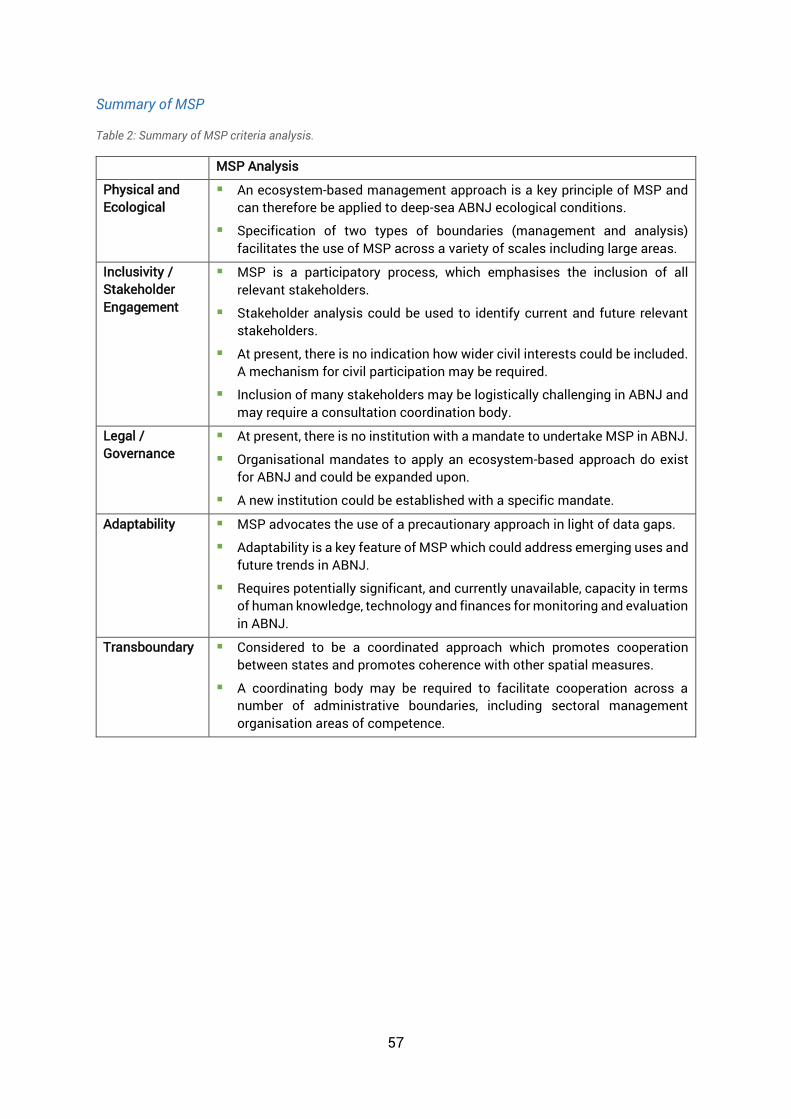
57
Summary of MSP
Table 2: Summary of MSP criteria analysis.
MSP Analysis
Physical and Ecological
An ecosystem-based management approach is a key principle of MSP and can therefore be applied to deep-sea ABNJ ecological conditions.
Specification of two types of boundaries (management and analysis) facilitates the use of MSP across a variety of scales including large areas.
Inclusivity / Stakeholder Engagement
MSP is a participatory process, which emphasises the inclusion of all relevant stakeholders.
Stakeholder analysis could be used to identify current and future relevant stakeholders.
At present, there is no indication how wider civil interests could be included. A mechanism for civil participation may be required.
Inclusion of many stakeholders may be logistically challenging in ABNJ and may require a consultation coordination body.
Legal / Governance
At present, there is no institution with a mandate to undertake MSP in ABNJ.
Organisational mandates to apply an ecosystem-based approach do exist for ABNJ and could be expanded upon.
A new institution could be established with a specific mandate.
Adaptability MSP advocates the use of a precautionary approach in light of data gaps.
Adaptability is a key feature of MSP which could address emerging uses and future trends in ABNJ.
Requires potentially significant, and currently unavailable, capacity in terms of human knowledge, technology and finances for monitoring and evaluation in ABNJ.
Transboundary Considered to be a coordinated approach which promotes cooperation between states and promotes coherence with other spatial measures.
A coordinating body may be required to facilitate cooperation across a number of administrative boundaries, including sectoral management organisation areas of competence.

58
8.2 Marine Protected Areas (MPAs)
Marine Protected Areas (MPAs) have been a topic of international discussion for many years. At present, within national jurisdictions, MPAs are designed to meet the specific needs of the country, for example economic, cultural, and social and conservation needs, and are implemented in accordance with national law and/or regional legal instruments, for example the EU Birds and Habitats Directive. As such, there are a wide range of MPA types and considerations as to what constitutes an MPA. Fisheries closures are not considered to be MPAs. They are a type of management tool adopted to maintain or prevent fish stock collapse, for example closures to protect nursery or spawning grounds (Day et al. 2012). For the purposes of this review, the IUCN and CBD definitions of a Protected Area will be used. These definitions are considered to be equivalent (Lopoukhine & Ferreira de Souza Dias, 2012). In accordance with these definitions, only areas in which the main objective is nature conservation are considered to be protected areas in this review.
In ABNJ, MPAs have already been designated in certain regions, for example the North East Atlantic, Southern Ocean, the Pacific Ocean and the Mediterranean Sea (Gjerde et al., 2016). However, at present, there is no legal mechanism through which to designate MPAs in ABNJ in all locations and that are applicable to all nations. Existing MPA designations are not legally binding beyond the Contracting Parties to Regional Seas Conventions, as is the case with OSPAR and CCAMLR decisions and recommendations (Tanaka, 2012). As such, MPAs (along with other types of area-based planning tools) are being considered in international discussions on the development of a new implementing agreement for the conservation and sustainable use of BBNJ under the LOSC [A/RES/72/249] (UNGA, 2017b), which could potentially provide a coherent legal framework for their designation in ABNJ.
This review focuses primarily on three sets of IUCN Guidelines:
IUCN Guidelines for Applying Protected Area Management Categories (Dudley et al. 2008);
IUCN Guidelines for Applying the IUCN Protected Area Management Categories to Marine Protected Areas (Day et al. 2012) (which specifically note the potential application of MPAs in the High Seas); and
Large-Scale Marine Protected Areas (Lewis et al. 2017).
Definition
“A clearly defined geographical space, recognised, dedicated and managed, through legal or other effective means, to achieve the long-term conservation of nature with associated ecosystem services and cultural values.” (Dudley et al. 2008)
“[A] geographically defined area which is designated or regulated and managed to achieve specific conservation objectives” (CBD, 1992, Article 2)

59
Examples of regional guidance for MPAs in ABNJ is provided by the OSPAR Guidelines on the Identification of MPAs (OSPAR, 2003a), and the OSPAR MPA Management Guidelines (OSPAR, 2003b). It is also acknowledged that other guidelines on MPAs in relation to a particular sector are available, for example the FAO Technical Guidelines on MPAs and Fisheries24. However, it is beyond the scope of this review to examine all existing guidelines. A complete list of guidance documents used in this review can be found in Annex 2.
Physical and Ecological Characteristics (including Scale)
The use of an ecosystem approach is advocated, whereby protected areas are not considered isolated entities, but rather are integrated within broader-scale conservation approaches (Dudley et al., 2008, p.10). For large-scale MPAs, it is also noted that they provide an opportunity to implement an ecosystem-based management approach, through which entire ecosystems can be protected (Lewis et al., 2017). Examples of biophysical operational principles from the Great Barrier Reef Marine Park are provided in the guidelines to support this statement (Lewis et al., 2017, p.32).
More specifically in the case of the North East Atlantic, the OSPAR Guidelines advocate the establishment of an “ecologically coherent network of well-managed MPAs” (OSPAR 2003a, p.1). To support this, a set of ecological criteria including, inter alia, threatened or declining species, high natural biological diversity, representativity and sensitivity, are provided for use in combination with practical criteria, such as size, potential for restoration and scientific values (OSPAR, 2003a). The consideration of MPAs as part of a wider system or network would facilitate the consideration of large-scale ecological processes, such as larval dispersal or marine mammal migration. As such, the application of MPAs as a wider system or network could be particularly useful in the vast and often highly connected ABNJ, and also to address links between waters within and beyond national jurisdiction. Regional particularities do exist and therefore the design of an area-based planning tool will need to consider the regional context, which can result in significant regional variation in tools.
In addition, due to the three-dimensional nature of the marine environment, it is recognised that there is a requirement for different management approaches at different depths in certain circumstances (Dudley et al., 2008; Day et al., 2012). For example, vertical zoning to address different issues in the water column and on the seabed. Vertical zoning within MPA designations could be particularly relevant in ABNJ where extended continental shelf claims exist, whereby the seabed falls under national jurisdiction, but the superjacent water column does not. One example of such is the Rainbow Hydrothermal Vent Field MPA, an OSPAR protected area (UNEP-WCMC & IUCN, 2018a) situated in the water column above seabed closures in the area of the Portuguese extended continental shelf claim, where the seabed is designated by Portugal as Campo Hidrotermal Rainbow (UNEP-WCMC & IUCN, 2018b).
24 Full text available at: http://www.fao.org/docrep/015/i2090e/i2090e.pdf

60
Such measures provide water column and seabed protection from human activities both laterally and vertically across the area.
Dudley et al. (2008) include six management categories of protected area25, each with different characteristics and objectives. Day et al. (2012) provide notes on the application of each management category to MPAs specifically. All six categories could theoretically be applied in ABNJ. However, depending on the condition of the area and the activities permitted under the MPA objectives, some management categories will be more applicable than others. For example, Categories V and VI, could be used in ABNJ in which multiple uses occur (such as fishing and seabed exploration) or if the number of uses in one areas is likely to increase (such as marine scientific research or seabed mining) (Day et al., 2012). Additionally, some categories, for example category III, include aspects such as education or visitor opportunities that would be of limited relevance in ABNJ. Management categories can however be used in combination through zoning. For example, strictly protected areas nested within a less strictly protected area can protect significant features within a broader area that is itself ecologically significant. Thus the management categories provide a wide array of options for implementation in ABNJ, which can be selected based on protection requirements, scale considerations and influence of human activities.
Inclusivity / Stakeholder Engagement
Dudley et al. (2008) suggest that key stakeholders and other relevant interests should be identified and involved in the development of primary management objectives for the designation of an MPA (p.34). In support of this, the importance of active stakeholder and public involvement early on in the planning process is also noted in other guidelines (Lewis et al., 2017; OSPAR, 2003b). Further, the OSPAR Management guidelines specifically require the identification of relevant stakeholders in the management plan itself (OSPAR, 2003b) and OSPAR has developed ‘Guidance for good practice for communicating with stakeholders on the establishment and management of marine protected areas’ to support this (OSPAR, 2008). In ABNJ, many relevant stakeholder may exist but may not be recognised by one another. As such, the identification and involvement of stakeholders can improve understanding and awareness of different activities occurring within vast ABNJ and help to prevent future conflicts, or undermining of management actions. The identification of specific stakeholders in the text of management plans would improve stakeholder visibility. In addition, inclusion of a list of stakeholders in management plans can facilitate assessment of stakeholder cooperation and participation in the area-based planning process by detailing certain requirements, for example, frequency of communication or the establishment of working groups. These details may be particularly useful in ABNJ, where there is no overarching body to coordinate stakeholder engagement for general matters –
25 Management Categories include: Ia, Ib, II, III, IV, V, and VI (Dudley et al, 2008). Further information can be found on Protected Planet

61
beyond the capacity of RFMOs to do so for fisheries matters— and thus coordination could be tracked by the implementing authority.
Regarding mechanisms for engagement, the collection of guidelines provide various suggestions. Firstly, the establishment of working groups or committees that are representative of all relevant stakeholders (Dudley et al., 2008). In ABNJ, multiple sites or a system of sites may be required to comprehensively address issues at the required scale. Stakeholder working groups could therefore facilitate the collection and review of data from multiple sites and ensure consistency across the network or system (Dudley et al., 2008). Secondly, the establishment of advisory councils to initiate a dialogue between stakeholders and ensure stakeholder participation throughout the entire process (i.e. planning, implementation and monitoring) (Lewis et al., 2017). Due to the development of numerous activities within ABNJ, it is likely that new relevant stakeholders may need to be considered in the future. Advisory councils, could provide oversight on stakeholder communication and identify future relevant stakeholders.
Legal and Governance Framework
The guidelines produced by IUCN, encourage working towards “a clear and equitable governance system” for all protected areas (Dudley et al., 2008, p.11), and to utilise existing legal frameworks to support management commitments (Lewis et al., 2017). In addition, the IUCN protected area definition used in the guidelines (as above) notes the use of “legal or other effective means” to achieve the long-term conservation of nature, which would include management measures where biodiversity conservation is the primary objective. In the case of ABNJ, there is currently no legal mechanism through which MPAs can be designated as binding upon all countries. In addition, there is no overarching authority with the legal mandate to designate globally binding MPAs. However, some regional conventions have a legal mandate to designate regionally binding MPAs, including the OSPAR Convention (1992) in the North East Atlantic, the Convention on the Conservation of Antarctic Marine Living Resources (CCAMLR) (1980) in the Southern Ocean, the Barcelona Convention (1976) in the Mediterranean Sea and the Noumea Convention (1986) in the South Pacific. For example, the Pelagos Sanctuary for Marine Mammals was established in 1999 by France, Italy and Monaco (Accord Mediterranée, 1999). The sanctuary encompasses the territorial waters, and the adjacent water column beyond the national jurisdictions, of the three countries in the Mediterranean Sea. In 2001, the sanctuary was recognised as a Specially Protected Area of Mediterranean Importance (SPAMI) under the Barcelona convention and a joint management plan adopted to implement additional measures (Gjerde et al., 2016).
Adaptability
According to Dudley et al. (2008), all protected areas should aim to “use adaptive management strategies to improve management effectiveness and governance quality over time” (p.11) and “be operating under the guidance of a management plan, and a monitoring and evaluation programme that supports adaptive management” (p.12). The evolution, adaptation and
62
restoration potential of larger and more natural protected areas or networks, such as those that could be implemented in ABNJ, is also noted.
In addition, many large-scale MPAs require more capacity and support at national government than their smaller counterparts. Lewis et al. (2017) highlight the requirement for large-scale MPAs to be adaptable to changes in leadership at national government level, which could ultimately influence the provision of funding and capacity. These considerations may be important in ABNJ where national governments have no jurisdiction, but rather may support (i.e. provide capacity) the designation of MPAs as a gesture of goodwill or to protect common resources for future generations. Such support may be affected by changes in national government priorities, which can thus affect designation effectiveness.
Lewis et al. (2017) specify that a precautionary approach, which considers sociocultural, economic, political and environment factors, should be implemented in light of uncertainty, in relation to large-scale MPAs. The guidelines recognise that such an approach can lead to delays in implementation or adaption, however highlights its importance when there are substantive data gaps. A precautionary approach would be beneficial when designating MPAs in ABNJ as, due to the vast size and remoteness of these areas, there are often significant gaps in data. In addition, much of the deep-sea is unexplored and many oceanographic and ecosystem interactions in the deep-sea remain poorly understood. A precautionary approach would also act to minimise adverse impacts on such processes and unexplored habitats.
Further to this, Lewis et al. (2017) note the importance of monitoring, data collection and analysis for evaluating the effectiveness of management approaches. For example, in the creation of High Seas MPA management plans in the OSPAR region, States are encouraged under various recommendations26, to set out biological, environmental and/or usage monitoring programmes for each site. However, they are not legally bound to do so. It is also recognised that monitoring and evaluation systems require sufficient time and resources and need to have been in implementation for sufficient time to facilitate adequate data collection and evaluation. In ABNJ, there is no authority with the mandate to legally implement MPAs globally and thus limited capacity for monitoring. Consequently, the development and implementation of monitoring programmes is likely to rely heavily on voluntary contributions and good will at this stage.
Transboundary
Transboundary management of MPAs is recognised as a sub-type of shared governance under the IUCN Governance type classifications (Dudley et al., 2008). This governance type requires complementary or coordinated management measures for effective implementation. Example coordination measures include: jointly coordinated management actions within each sovereign area that contribute towards objectives for the entire
26 OSPAR Recommendations 2007-5, 2010/17 and 2012/1

63
transboundary ecosystem; jointly coordinated and implemented management actions across boundaries, for example joint law enforcement patrols; and the establishment of cooperative agreements between sites or organisations (Lewis et al., 2017). As there is no single sovereign entity in ABNJ, coordination will be required between existing sectoral bodies, such as regional fisheries bodies or regional seas conventions. However, due to a lack of a global coordination mechanism, coordination for measures such as joint enforcement, may prove challenging.
Dudley et al. (2018) emphasise the integration of protected areas into broader-scale approaches to conservation and sustainable use, commonly known as “bioregional approaches” or “ecosystems approaches”. The guidelines also recognise the need to consider the impacts of human activities in three dimensions, encouraging assessment of intrusive activities above or below protected areas, for example mining or dredging activities (Dudley et al., 2008). Such considerations are suitable for ABNJ that are vast in nature, highly connected and subject to multiple different uses at different depths within the water column or on the seabed, which can prove challenging to manage holistically. In the case of the North East Atlantic, OSPAR Guidelines for MPA Identification note that the network of MPAs should “take into account the linkages between marine ecosystems and the dependence of some species and habitats on process that occur outside the MPA concerned” (OSPAR, 2003a, Article 5). The guidelines therefore recognise the connectivity between vast areas of ocean and aim to ensure such connectivity is considered for the benefit of biodiversity. A review undertaken in 2013 (Johnson et al, 2014b) and a subsequent review in 2017 have determined that the MPA network in the OSPAR region is progressing significantly, however the network cannot yet be considered to be ecologically coherent (OSPAR, 2017).
However, the Guidelines for Large-scale MPAs recognise that broader scale or transboundary approaches can be accompanied by numerous challenges. These can include additional capacity requirements, broader stakeholder engagement and cooperation requirements, enforcement issues, conflicting jurisdictional or legal mandates and user conflicts (Lewis et al., 2017). These challenges are prominent in ABNJ due to their size and remoteness, differing mandates and priorities of sectoral organisations, limited capacity and data gaps, and will require consideration in the planning process. For example, assessment of required finance and capacity (technological, human) should be undertaken and considered in the design of an MPA.

64
Summary of MPAs
Table 3: Summary of MPA criteria analysis
MPA Analysis
Physical and Ecological
An ecosystem-based management approach is advocated for MPAs and therefore they would be applicable to all types of ecosystems, including deep-sea ecosystems in ABNJ.
MPAs can be established as a network to cover large areas or encompass large ecological processes, thus they are applicable for large-scale ABNJ.
Zoning of MPAs can provide for multiple uses in ABNJ and for wider consideration of different activities in future.
There is the potential for three-dimensional protection of deep-sea ecosystems through vertical zoning, supporting their use in areas in which there are overlapping governance regimes. For example, extended continental shelf claims or deep waters.
Inclusivity / Stakeholder Engagement
Stakeholders should be involved in the development of primary MPA objectives and throughout planning processes. This could prove challenging in ABNJ due to difficulties in identifying who comprised ‘the public’.
A mechanism for engagement will be required to coordinate stakeholder cooperation and communication, as well as the inclusion of relevant stakeholders in future. There is currently no mechanism for engagement in ABNJ and would require establishment.
Legal / Governance
At present, there is no legal mechanism for— or overarching authority with the mandate to— designate globally binding MPAs in ABNJ.
Regional conventions provide mandates for regionally binding MPAs in ABNJ (e.g. OSPAR, CCAMLR).
Adaptability Advocates the use of a precautionary approach where there are data gaps, as is often the case in ABNJ.
Adaptability is a key feature of MSP which could address emerging uses and future trends in ABNJ.
Requires significant capacity for monitoring and evaluation of large-scale MPAs ABNJ.
Transboundary Transboundary management is recognised as a sub-type of shared MPA governance.
MPAs could enable coordinated management measures in areas and across boundaries i.e. joint management, as is the case in some regional organisations. Implementation of coordinated measures may be challenging in ABNJ due to the lack of a global coordination mechanism.
Significant capacity is required to undertake transboundary approaches.

65
8.3 Particularly Sensitive Sea Areas (PSSAs)
Particularly Sensitive Sea Areas (PSSAs) are management measures designated by the International Maritime Organization (IMO). The designation of PSSAs is based on the Revised Guidelines for the Identification and Designation of Particularly Sensitive Sea Areas (IMO, 2005, Res A.982(24)), as amended through resolution MEPC 27(68) in 2015. The guidelines establish that identification and designation will require consideration of particular attributes within an area, vulnerability of the proposed area to damage by international shipping and the availability of associated protective measures. The guidelines are applicable to waters both within and beyond the limits of the territorial sea and provide for the procedure to designate areas in which shipping measures under international Treaties, such as the MARPOL Convention and SOLAS Convention27, will apply. Since the adoption of the first guidelines (1991) and revised guidelines (2005), fifteen PSSAs, one of which has been extended twice, have been designated within national jurisdictions, including, inter alia, the Galapagos Archipelago, Great Barrier Reef and Wadden Sea. However, at present, there are no PSSAs implemented within ABNJ.
Physical and Ecological Characteristics (including Scale)
The IMO’s identification and designation guidelines for PSSAs set out ecological, socio-economic and scientific criteria to aid in the identification of PSSAs. Proposed areas must meet at least one criteria and have sufficient evidence of shipping impacts for consideration as a PSSA. Ecological criteria include uniqueness or rarity, critical habitat, diversity, naturalness, fragility, biogeographic importance, and note the potential risk to hydrographic, meteorological or oceanographic conditions from shipping activities (IMO, 2005, Article 4.4). Most of these ecological criteria are applicable to large, deep-sea ABNJ. Table 4 below provides examples of ecological criteria relevance in ABNJ.
27 International Convention for the Safety of Life at Sea (SOLAS). 1 November 1974. 1184 UNTS 3. Entry into force 25 May 1980
Definition
“A Particularly Sensitive Sea Area (PSSA) is an area that needs special protection through action by the International Maritime Organization (IMO) because of its significance for recognized ecological or socio-economic or scientific reasons and which may be vulnerable to damage by international maritime activities.” (IMO, 2005)

66
Table 4: Illustrative example ecological criteria for PSSA identification and their relevance to ABNJ (IMO, 2005)
Criteria Relevance to ABNJ Uniqueness or rarity
Notes that “an ecosystem may extend beyond country borders, assuming regional or international significance.” (IMO, 2005, Article 4.4.1) This criteria recognises the potential for different scales of ecosystems and recognises that ecosystems do not necessarily align with administrative boundaries. This could also apply to ecosystems which extend beyond the limits of national jurisdiction and are thus transboundary in nature.
Critical Habitat Recognise the importance of critical habitats to support larger marine ecosystems, such as those in ABNJ (IMO, 2005, Article 4.4.2), indicating that an ecosystem approach can be taken.
Dependency Relates to the biological structure of an area, upon which ecological processes are highly dependent. This criteria encompasses the migratory routes of various different taxa, including fish, birds and mammals. Consideration of migratory routes can be important in helping to provide adequate protection for these species throughout their entire range, which can often include multiple national jurisdictions and ABNJ.
Naturalness Describes an area that has undergone a “relative lack of human-induced disturbance or degradation”. Many ABNJ are relatively remote and as such, may have experienced a lack of human disturbance compared to their coastal water counterparts and could therefore be considered to be relatively intact.
Fragility Describes the susceptibility of an area to degradation from natural or anthropogenic pressures. The guidelines make specific reference to coastal habitats and provide examples of different stressors, but make no reference to deep-sea ecosystems. However, deep-sea ecosystems can be fragile, thus making this criteria applicable. It may be challenging to assess or determine potential impacts of international shipping on these ecosystems.
Inclusivity / Stakeholder Engagement
The PSSA Guidelines aim to ensure that “all interests, including those of Coastal States, Flag States and the environmental and shipping communities are thoroughly considered on the basis of relevant scientific, technical, economic and environmental information regarding the area at risk” (IMO, 2005, Article 1.4.2). Article 8.3.1 states that the Marine Environment Protection Committee (MEPC) bears primary responsibility for assessing PSSA applications and where appropriate, “should establish a technical group comprising representatives with appropriate environmental, scientific, maritime, and legal expertise” to fully consider applications (IMO, 2005). PSSAs in ABNJ have not yet been tested and so from an ABNJ perspective, there has not previously been a need to include ABNJ-relevant stakeholders in technical groups. The IMO Guidelines note the potential for two or more Member Governments, with a common interest in a particular area, to develop a co-ordinated proposal containing “integrated measures and procedures for co-operation” (IMO, 2005, Article 3.1). However, protective measures and co-operation procedures are adopted under international treaties (for example

67
MARPOL and SOLAS) and only Parties to these treaties may agree on such measures or procedures.
Legal and Governance Framework
The International Maritime Organization (IMO) is the competent international organisation with a mandate to regulate and set the global standards for shipping activities both within and beyond the limits of national jurisdiction. As such, the IMO is the only authority through which PSSAs can be designated following application by IMO Member Governments. The PSSA Guidelines set criteria for the identification and designation of PSSAs and explicitly state that criteria relate to PSSAs within and beyond the limits of the territorial sea (IMO, 2005, Article 4.3), thus they might extend to ABNJ. However, this is dependent upon what IMO Member Governments may legally implement and enforce as Parties to the international treaties under which shipping measures can be adopted.
In addition, applications must include one or more ‘associated protective measures’ (APMs), which describe the legal regulation of shipping activities to prevent, reduce or eliminate vulnerabilities identified within the proposed area (IMO, 2005). This could include ships’ routeing measures, reporting requirements, discharge restrictions or prohibited activities, but could be based on any measures approved or adopted by IMO, and therefore has an identified legal basis. Protective measures are imposed upon ships and their application may place a higher financial or technological burden upon ships operating within or in proximity to PSSAs so that they comply. If sufficient associated protective measures do not yet exist, the requirement to seek IMO approval for new protective measures places an additional administrative and capacity burden on the proponent Member Governments.
Adaptability
The PSSA Guidelines state that “all interests… will be thoroughly considered on the basis of relevant scientific, technical, economic and environmental information regarding the area at risk of damage…” (IMO, 2005, Article 1.4.2). Such information may be hard to come by for ABNJ and proposals are unlikely to be put forward on a precautionary basis without sufficient scientific information. In line with this, no proposals to designate PSSAs in ABNJ have been put forward to date. Reasons for this are thought to be related to limited State implementation and enforcement jurisdiction in ABNJ, a lack of impacts and a lack of information on any impacts of international shipping in the deep-sea, in comparison to coastal waters under national jurisdiction (UNEP-WCMC, 2017).
The PSSA guidelines set out criteria for the designation of PSSAs and do not set out any provisions for monitoring of PSSAs and associated protective measures – these are adopted under relevant international treaties of IMO. In light of future vulnerabilities, PSSA designations can be adapted through the implementation of additional associated protective measures (IMO, 2005, Article 7.3) and the IMO provides a forum for review and re-evaluation of any associated protective measure (IMO, 2005, Article 8.4). For example, discussions on protective measures take place in regular meetings of the MEPC and MSC,

68
at which Parties to the IMO treaties are in attendance. Amendments to the treaties are made via this process. It is through this mechanism that Ecuador submitted a request to the IMO for the addition of a mandatory ship reporting system and a new device for the traffic separation scheme as associated protective measures for the Galapagos Archipelago PSSA (Lefebvre-Chalain, 2007). Such measures would allow for PSSAs in ABNJ to be adapted in light of changes resulting from emergent uses, changes in activity intensity or climate change. Member Governments operating in the area of the designated PSSA, as well as the Proponent Government, are also encouraged to raise any concerns so that adjustments to protective measures can be made. However, the general guidelines do not specify a period for regular review, nor do they indicate the process for adapting existing measures.
Transboundary
The PSSA Guidelines provide for coordinated PSSA proposals if two or more Member Governments have a common interest in an area. Such proposals would require integrated measures and procedures for cross-jurisdictional cooperation. Coordinated proposals could be submitted for areas of common interest beyond the limits of national jurisdiction and could facilitate the sharing capacity burdens for proposal and implementation between multiple Governments.
With regard to management boundaries, the guidelines note that when assessing a PSSA proposal, particular consideration should be given to identifying whether associated protective measures may result in “an increased potential for significant adverse effects by international shipping activities on the environment outside the proposed PSSA” (IMO, 2005. Article 8.2.2). Such considerations are important within ABNJ as deep-sea ecosystems may cover large areas, for which there is often a lack of comprehensive data. Reducing pressure in one fragile area through management measures such as PSSAs, may result in increased pressure in proximate areas, which may also be fragile or critical to overall ecosystem functioning. By taking this into consideration, the PSSA process is, to some extent, adopting a precautionary, ecosystem-based approach.

69
Summary of PSSAs
Table 5: Summary of PSSA criteria analysis
PSSA Analysis
Physical and Ecological
A number of ecological criteria for PSSA designation are relevant to ABNJ, for example uniqueness or rarity, critical habitat and naturalness.
Inclusivity / Stakeholder Engagement
Technical working groups comprising representatives with “appropriate environmental, scientific, maritime and legal expertise” to consider applications, providing a mechanism for engagement. Relevant stakeholders are generally included at the national/regional level prior to submission of a proposal to IMO. Civil society is represented by Observer organisations.
Co-ordinated proposals are suggested, and must include cooperation procedures. However, these can only be put forward by IMO Member States, making it challenging in ABNJ.
Legal / Governance
The IMO is the only authority through which PSSAs can be designated.
Criteria for identification and designation of PSSAs relate to within and beyond the limits of the territorial sea.
Associated protective measures are legally binding upon ships operating in the protected areas, irrespective of where those ships are registered.
Adaptability Advocates the use of a precautionary approach where sufficient scientific information is lacking.
No requirements for monitoring. However, there is a requirement for review and re-evaluation of associated protective measures.
Transboundary Coordinated proposals can be submitted by multiple IMO Member States which require “integrated measures and procedures for cross-jurisdictional cooperation.”
Transboundary considerations for any potential adverse impacts of international shipping in proximate areas following the implementation of associated protective measures.

70
8.4 Areas of Particular Environmental Interest (APEIs)
Areas of Particular Environmental Interest (APEIs) are a sectoral area-based planning approach used specifically to protect biodiversity and ecosystem structure and functioning from the potential impacts of deep-sea mining (ISA, 2018c). APEIs are implemented by the International Seabed Authority (ISA) – the competent authority mandated to regulate deep-sea mining activities. APEIs are developed through a Regional Environmental Management Plan Process.
At present, APEIs are only implemented in the Clarion-Clipperton Zone (CCZ) in ABNJ in the eastern central Pacific Ocean. APEIs were first suggested in a proposed Environmental Management Plan for the CCZ [ISBA/17/LTC/7] (ISA, 2011), which was adopted (including guidance and provisions on APEIs) in 2012, under decision [ISA/18/C/22] (ISA, 2012). The management plan and the adoption decision will be used in the following review (full titles are provided in Annex 2). The ISA has begun the development of Regional Environmental Management Plans for cobalt crust seamounts in the Northwest Pacific Ocean and polymetallic massive sulphides at the North Atlantic and Indian Ocean mid-ocean ridges (Dunn et al., 2018). The Regional Environmental Management Plans will be implemented by 2020, based on principles and area-based planning tools similar to those in the CCZ.
Physical and Ecological Characteristics (including Scale)
APEIs have been designed specifically for implementation in ABNJ and aim to address issues at this scale. The Environmental Management Plan is founded upon the guiding principle of conservation and sustainable use of biodiversity. As such, APEIs aim to protect biodiversity and ecosystem structure and function (ISA, 2011, Article 39(a)). APEIs are designed to support this objective by incorporating areas of sufficient size to protect and ensure the ecological viability of ecosystems and features.
The Clarion-Clipperton Zone area (approx. 4.5 million km2 in size) has been divided into nine sub-regions based on productivity-driven gradients in ecosystem structure and function (ISA, 2011, Article 24). The plan requires the designation of an APEI within each sub-region, the dimensions of which must be 400x400km (a 200x200 km core area surrounded by a 100km buffer zone) (ISA, 2011, Article 25), equating to roughly twenty-five per cent of the CCZ under management protection (Lodge et al., 2014). In 2016, the creation of two additional APEIs in the CCZ region was considered (ISA, 2016), which would increase the area of the CCZ under management protection to roughly twenty-nine per cent (Dunn et al., 2018). The specification
Description
Areas thought to be representative of the full range of habitats, biodiversity and ecosystem structure and function within a defined management area that are closed to potential mining activities in order to protect and preserve the marine environment (ISA, 2011).

71
of APEIs on this vast scale highlights the suitability of such tools for implementation in ABNJ.
The management plan identifies deep seabed habitats (from 2000 to 6000m in depth), such as seamounts, deep-sea ridges and flat-floored valleys, which could be considered in the selection of an APEI (ISA, 2011, Article 15). However, APEIs are seabed closures and do not include the water column. Consequently, other water column activities, such as fishing or marine scientific research, could still take place. Thus coordination with other sectors may be required to provide three-dimensional protection for biodiversity in these areas into the future.
APEIs have been developed for application in ABNJ, however, are currently tailored to the conditions and characteristics of the Clarion-Clipperton Zone region. The ISA has been invited to consider the development of environmental management plans, which may include APEIs, for other regions under Article 51 of UNGA Resolution 68/70 (2013), for example, in the Atlantic (Dunn et al. 2018). As such, there is scope for refinement of APEIs and a broader application across ABNJ for the purposes of biodiversity conservation.
Inclusivity / Stakeholder Engagement
The CCZ APEIs were developed during a multi-disciplinary expert workshop to ‘Design Marine Protected Areas for Seamounts and the Abyssal Nodule Province in Pacific High Seas’ (2007) (ISA, 2008). Participants included geologists, ecologists, biological and physical oceanographers, conservationists, biologists and lawyers (Smith et al. 2010).
One of the key guidelines for designing APEIs is to ensure that the interests of all stakeholders, including mining claim holders and other stakeholders operating in the Area, are incorporated. In line with this, the ISA Decision to adopt the Environmental Management Plan encourages further dialogue with all stakeholders to ensure complementarity with regard to proposed APEIs (ISA, 2012, Article 5). In particular, this has taken place with the International Cable Protection Committee (Johnson, 2017). Additionally, affiliated NGOs, such as the Deep Sea Conservation Coalition (DSCC)28, have the opportunity to participate in various ISA meetings, the most recent of which was the Twenty-Fourth Annual Session of the ISA, during which the DSCC submitted statements and interventions (IISD, 2018). Under the Environmental Management Plan’s guiding principle of Transparency, the ISA is also required to facilitate public participation in environmental decision-making procedures in accordance ISAs rules and procedures and other conventions29.
When developing APEI recommendations, the Environmental Management Plan specifically notes communication of an APEI’s management goals to other competent authorities responsible for the management of the water column (ISA, 2011, Article 43(e)). The plan
28 Further information on the DSCC can be found at: http://www.savethehighseas.org/ 29 Convention on Access to Information, Public Participation in Decision-Making and Access to Justice in Environmental Matters (1998) – Aarhus Convention.

72
encourages competent intergovernmental organisations to adopt compatible measures for other activities that may affect biodiversity. In addition, the ISA is encouraged to communicate a desire to foster collaborative scientific activities within the Clarion-Clipperton Zone (ISA, 2011, Article 43(f)). Such provisions indicate recognition of the need for a holistic management approach, through which the seabed and water column can be protected for the conservation and sustainable use of biodiversity. Collaborations between the ISA and other organisations are already occurring in the North East Atlantic. Such collaborations can facilitate marine scientific research and data sharing. These activities can support vulnerability assessments of deep-sea habitats and assessment of the effectiveness of biodiversity-related conservation measures in North East Atlantic ABNJ (UNEP-WCMC, 2017).
Legal/Governance
The ISA is mandated under the LOSC to ensure effective protection of the marine environment from the harmful effects of deep-sea mining activities in ‘the Area’ (LOSC, Article 145). More specifically, the Legal and Technical Commission of the ISA is responsible for making recommendations on the protection of the marine environment and for the review of rules, regulations and procedures. For example, the designation of APEIs and the appropriateness of their locations (ISA, 2011). The existence of thus Legal and Technical Commission, a scientific body with a dedicated review mandate (ISA, 2011), is beneficial in supporting effective implementation of APEIs. Further legal and governance information pertaining to the ISA is provided in UNEP-WCMC (2017).
Adaptability (including monitoring and data collection)
The Environmental Management Plan for the CCZ and the designation of APEIs are precautionary in nature, as seabed mineral extraction activities have not yet begun in the region. At present, comprehensive information on the impacts of seabed mining on deep-sea ecosystems is lacking, with many impacts inferred from analytical computer models or from small test sites elsewhere. In 2013, the European Union funded the Managing Impacts of Deep-seA reSource exploitation (MIDAS) project to investigate the environmental impacts of extracting mineral and energy resources from the deep-sea environment (Lodge et al., 2014). Data and information collected by the project was used to develop recommendations for best practice in the mining industry (MIDAS, 2016). ISA decision [ISBA/18/C/22] stipulates that the environmental management plan, will be applied in a flexible manner, thus enabling adaptation in light of new scientific, technical and environmental data, such as that from the MIDAS project.
It is the responsibility of the Legal and Technical Commission to make recommendations on, and coordinate the implementation of a monitoring programme for APEIs in the Clarion-Clipperton Zone (ISA, 2011, Article 4(c, d)). However, a monitoring programme has yet to be established due to a lack of consensus on a number of issues. These issues include, the frequency of monitoring activities, who will be responsible for assessing monitoring results,
73
who will conduct monitoring and who will finance such activities (ISA, 2017). Such considerations are likely to be a key consideration in upcoming negotiations on the text of a new implementing agreement for BBNJ and may depend on existing or the establishment of new organisational mandates.
The nine existing APEIs have been designated on a provisional basis based on best available scientific information. Designations will be provisional for a period of five years (from 2012) or until further review by the Legal and Technical Commission, during which time, no application for exploratory activities within these areas will be approved (ISA, 2012, Article 6). As there is a significant lack of data for ABNJ, the procedure to provisionally close areas with suspected biodiversity and ecosystem importance could be applied to different activities until sufficient data has been collected.
In its decision to adopt the Clarion-Clipperton Zone Environmental Management Plan, the ISA encourages marine scientific research in APEIs (ISA, 2012, Article 8). However, the ISA does not set out legal obligations for contractors to collect and supply environmental data for APEIs and the quantity and quality of data can vary between contractors (Lodge et al., 2014). Consequently, in a 2016 review of the Environmental Management Plan, the paucity of data for the region was highlighted as a key issue, requiring increased sharing of contractor-collected data. To date, environmental data has been collected in six of the nine APEIs via research cruises and contractor collection. However, it has been suggested by Johnson and Ferreira (2015) that a more comprehensive mechanism and incentives to undertake such data collection need to be identified.
Transboundary
One of the stated objectives of APEIs is to establish an area that avoids overlap between current contractor and reserve areas (ISA, 2011, Article 39(c)). This is to ensure that the selected areas will be representative of healthy ecosystem function and biodiversity and will not be at risk from the adverse impacts of exploratory activities and eventually, exploitation and extraction activities within contractor areas. However, the environmental management plan and associated APEIs were established retroactively, after exploration contracts for the area had been agreed, the first of which was agreed in 2001 (ISA, 2001, ISBA/7/A/2).
The design of APEIs consists of a 200 x 200 km core zone surrounded by 100 km a buffer zone. Such a buffer zone provides an additional level of protection to the core area from the impacts of mining activities in proximate contractor areas, which are presumed to be far reaching, such as sediment plumes. Such contingency measures are important to ensure the conservation of biodiversity and this premise could be used to mitigate adverse impacts from a range of activities, on a range of different scales.

74
Summary of APEIs
Table 6: Summary of APEI criteria analysis
APEI
Physical and Ecological
Founded upon the guiding principles of conservation and sustainable use of biodiversity.
Designed to incorporate areas of sufficient size to protect and ensure the ecological viability of ecosystems and features.
Seabed closures and thus do not include the water column above. Cross-sectoral coordination may be required for three-dimensional protection.
There is scope for refinement of APEI design for broader application beyond the CCZ, which is already underway in other regions.
Inclusivity / Stakeholder Engagement
One of the key guidelines for designing APEIs is to ensure the interests of all stakeholders are considered.
Under its principle of Transparency, the ISA is required to facilitate public participation in environmental decision-making. Although no mechanisms for this are noted.
Communication of APEI objectives to other competent authorities and encourages other competent intergovernmental organisations to adopt compatible measures.
Legal / Governance
The ISA is mandated under the LOSC to ensure the effective protection of the marine environment from the harmful effects of deep-sea mining activities in the Area.
The Legal and Technical Commission is responsible for making recommendations on the protection of the marine environment and the review of designations and regulations.
Adaptability APEIs in the Clarion-Clipperton Zone have been provisionally designated based on best available information and are precautionary in nature as seabed mining activities have not yet begun (as of July 2018).
A monitoring programme has not yet been established for APEIs in the Clarion-Clipperton Zone due to a lack of consensus
Transboundary The ISA aims to prevent overlap between APEIs, contractor areas and reserve areas. However, the Environmental Management Plan and associated APEIs were established after exploration contracts had been awarded.
APEIs consist of a 200 x 200 km core zone surrounded by a 100 km buffer zone to provide contingency against potentially widespread mining impacts from proximate areas.

75
8.5 Fisheries closures related to the protection of vulnerable marine ecosystems (VMEs)
Many different types of management measures are employed by Regional Fisheries Management Organisations or Arrangements (RFMO/As) within their areas of competence. For example, deep-sea RFMO/As generally only have small areas that are open to fishing. These areas are limited to historical fishing footprints, and exploratory fisheries protocols are applied in the remaining areas. Other examples include the use of ‘move on’ rules when a fishing vessel encounters a set number of VME indicator species, by-catch measures and extensive spatial measures for fish stocks. The application of management measures is determined by individual RFMO/As based on their specific needs and objectives, resulting in many different interpretations of a particular measure. This review focuses on fisheries closures related to the protection of vulnerable marine ecosystems as a specific type of tool from which lessons on tool application in ABNJ can be learned.
Fisheries closures within national jurisdictions are designed and implemented at the national level by relevant national authorities, and as appropriate, by the European Union under the Common Fisheries Policy. In ABNJ, fisheries management is the responsibility of Regional Fisheries Bodies (RFB), which include RFMO/As with specific mandates for deep-sea fish stocks or highly migratory species such as tuna (for example the International Commission for the Conservation of Atlantic Tunas (ICCAT) or the Inter-American Tropical Tuna Commission (IATTC)). At present, deep-sea RFMO/As implement measures to protect VMEs from significant adverse impacts, in accordance with FAO’s voluntary International Guidelines for the Management of Deep-Sea Fisheries in the High Seas (FAO, 2009). The role of the guidelines is to facilitate and encourage States and RFMOs towards the sustainable use of marine living resources, prevention of significant adverse impacts on deep-sea ecosystems and the protection of marine biodiversity.
It is recognised that bespoke measures relating to the protection of VMEs are applied by different RFMO/As in their areas of competence depending on their needs, for which many have specific guidance. However, this review focuses on FAO’s voluntary International Guidelines for the Management of Deep-Sea Fisheries in the High Seas. These guidelines provide an overarching framework under which RFMO/As can develop bespoke management measures and thus provide an opportunity to identify lessons that may be applicable to a cross-sectoral area-based planning framework in ABNJ.
Description of Vulnerable Marine Ecosystems (VMEs)
Marine ecosystems considered to be vulnerable to significant adverse impacts from fishing with bottom contact gear on account of the characteristics they possess, for example uniqueness or rarity, fragility or structural complexity (adapted from FAO, 2009).
76
Physical and Ecological Characteristics (including Scale)
The FAO guidelines pertain specifically to the management of deep-sea fisheries and so focus predominantly on deep-sea ecosystems. The guidelines set out a number of criteria for VME identification based on ecological or biogeographic ecosystem characteristics. For example, functional significance of the area, fragility, structural complexity and life-history traits of component species (para. 42).
In the FAO guidelines, States and RFMOs are encouraged to adopt and implement measures in accordance with an ecosystem approach to fisheries30. As such, the guidelines encourage the case-by-case adoption of conservation and management measures, which are considerate of VMEs and fish stocks, to prevent significant adverse impacts (para. 70). Example measures include bycatch reduction devices, gear restrictions, or changes in gear design to minimise seabed contact (para. 71).
Inclusivity / Stakeholder Engagement
A number of general management considerations are set out in the FAO guidelines, including to ensure transparency and public dissemination of information, and to enable participation of relevant stakeholders (para. 21(viii)). However, the guidelines do not provide guidance on mechanisms through which this can be achieved. Rather, it is the responsibility of individual RFMOs to involve stakeholders in line with their established procedures. States are also encouraged to “actively promote wide international cooperation” to support progress towards goals relating to conservation and sustainable use and Illegal, Unreported and Unregulated (IUU) fishing (para. 60).
The FAO guidelines encourage the development of mechanisms for communication, cooperation and coordination between RFMOs, relevant international organisations and scientific bodies (para 29). Examples of such mechanisms are not explicitly stated in the guidelines. However, examples could include the cooperation of RFMO/As and FAO to develop a global database on VMEs in ABNJ31. Collaboration with other sectors to ensure they are aware of the measures adopted by RFMO/As could prove useful in preventing or reducing the likelihood of user conflicts and ensuring that VME closures and other management efforts are not undermined by other sectoral activities. An example of this was necessary in the NAFO area following an interaction between oil exploration and a VME. An ‘information exchange’ mechanism is being proposed to avoid any future potentially overlapping activities (Kingston, 2018).
30 The Ecosystem Approach to Fisheries is an approach to fisheries management and development that “strives to balance diverse societal objectives, by taking into account the knowledge and uncertainties about biotic, abiotic and human components of ecosystems and their interactions and applying an integrated approach to fisheries within ecologically meaningful boundaries” (FAO, 2003, Article 1.2). 31 The FAO VME database can be found at: http://www.fao.org/in-action/vulnerable-marine-ecosystems/en/

77
Legal/Governance
The LOSC provides RFMO/As and the international treaties under which they are established with the legal competence and mandate to manage fisheries within ABNJ. This includes taking the necessary measures, such as adopting fisheries conservation and management measures, which are binding on their respective Member States and cooperating non-member States. RFMO/As exist in the majority of deep-sea ABNJ and undertake activities relating to data collection, fisheries assessments and monitoring. States are not obliged to become members of an RFMO/A (Ringbom & Henriksen, 2017), however there is a general obligation under the LOSC for States to cooperate in the management of fisheries (LOSC, Article 119; UNFSA, Article 5.) Access to High Seas fishery resources is possible if there is ‘real interest’ in the fishery and if the State intending to fish agrees to be bound by the rules and measures of the RFMO/A with competence in the relevant area. States intending to fish may be a member of the RFMO/A, or a cooperating, non-contracting party.
The FAO guidelines are voluntary in nature and not legally binding upon States. However, they provide a reference point on matters pertaining to the sustainable use of deep-sea fisheries and protection of VMEs – a primary responsibility of RFMOs and their Member States.
The FAO guidelines note the need to strengthen existing RFMOs through the incorporation of established principles of relevant international law into their mandates (para. 27). At the time of development (2009), the FAO guidelines note the need to “urgently cooperate to establish new RFMOs, where necessary and appropriate” (para. 28). Currently, there are seven deep-sea RFMOs, plus CCAMLR, which have a mandate to operate in ABNJ. In recognition of geographical gaps in RFMO coverage in ABNJ, and in attempts to reduce such gaps, three new deep-sea RFMOs (SIOFA, SPRFMO and NPFC) have been established since 2006, in line with UNGA Resolution 61/105. Gaps in coverage remain, however these are primarily for political reasons or because there are no deep-seas fisheries in that particular area. Where there is no RFMO in place, flag States are primarily responsible for ensuring its fishing vessels comply with general obligations to cooperate in the management of fisheries (LOSC, Article 119; UNFSA, Article 5), and Port States have a responsibility to ensure compliance.
Adaptability (including monitoring and data collection)
When designating VMEs, the guidelines note the use of a combination of selection criteria and best available scientific and technical information (para. 46). The sharing of existing biogeographic information between RFMOs is also encouraged (para. 37). The science-based approach is further supported by provisions that set out a number of requirements for data collection. These include, the need to establish data collection programmes, develop standards for consistent data collection, to collect data at all stages of fishery development, to also collect socio-economic data, and to submit data to FAO (FAO, 2009).
Where scientific knowledge of an area is limited, the FAO guidelines encourage implementation of a precautionary approach (para. 22). Areas designated as VMEs should

78
therefore be closed to deep-sea fishing until appropriate conservation and management measures have been established. This approach will help ensure long-term conservation and sustainable use of deep-sea marine living resources (para. 66).
The FAO’s guidelines are voluntary and flexible in nature. The application of measures for VMEs therefore differs across RFMOs. Some RFMOs may apply management measures of closures for bottom-fishing in order to protect VMEs. For example, in the South Pacific, the entire SPRFMO Convention Area has been closed to bottom trawling until Member States have submitted a ‘bottom fishing footprint’ and bottom fishing impact assessment of their flagged vessels’ activities (SPRFMO, 2018c, Article 8(a)). Such assessments are to be conducted in line with the Bottom Fishing Impact Assessment Standard (BIFAS), which aims to standardise the assessment approach and ensure that decisions relating to the protection of VMEs are based upon the best data available (SPRFMO, 2016). Other measures are also in place, including the requirement for vessels to “cease bottom fishing activities within five nautical miles of any site in the Convention Area where evidence of a VME is encountered…” (SPRFMO, 2018, Article 8(g)).
The FAO guidelines also encourage the development of a review mechanism. Such a mechanism facilitates the collection of new information and scientific advice. This information supports RFMOs in undertaking annual impact assessments, evaluation and adaptation of designations and management measures (para. 50). In recognition of the need for improved data collection and review, the guidelines encourage the adaptation of existing criteria and addition of new criteria for VME selection in light of increasing knowledge and expertise (para. 43). In line with this, new data on VME indicator species, such as deep water corals and sponges, within the NAFO Regulatory Area was made available to the NAFO Working Group on Ecosystem Science and Assessment to improve mapping of VMEs (NAFO, 2017a). Such information has resulted in amendments to a number of existing VME boundaries (NAFO, 2014; NAFO 2017b).
Transboundary
Deep-sea fisheries and habitats in ABNJ are the main focus of the guidelines. As such there is little mention of transboundary considerations. However, the guidelines recognise that some management measures may be limited in their effectiveness when implemented independently. Consequently, the FAO guidelines note the potential requirement for complementary measures, which engage other sectors (para. 72). While RFMOs are able to appropriately manage fisheries closures with the fishing nations in their Regulatory Area, their mandates not be sufficient to deliver upon the objectives of a VME in areas where other sectors are also operating. Therefore, the application of the management measures could be strengthened through cooperation and coordination with other sectors. In addition, In addition, during area-based planning processes, RFMOs aim to take into consideration the potential for coordinated transboundary management with coastal states regarding migratory or straddling fish stocks.

79
Summary of Fisheries Closures relating to the protection of VMEs
Table 7: Summary of Fisheries Closures criteria analysis
Fisheries Closures analysis
Physical and Ecological
VMEs are seabed habitats identified based on a number of ecological or biological ecosystem characteristics.
Deep-sea fisheries closures are one type of tool used to support the protection of VMEs through the mitigation of potential significant adverse impacts.
RFMOs are using the ecosystem approach to fisheries.
Inclusivity / Stakeholder Engagement
Individual RFMOs have responsibilities to involve relevant stakeholders in line with their established procedures.
Communication, cooperation and coordination between existing RFMOs is advocated.
Legal / Governance
RFMOs have the legal mandate under international law to govern fisheries in ABNJ. Seven deep-sea RFMOs, plus CCAMLR, have a mandate to manage deep-sea fisheries.
Fisheries measures (including VME closures) are only binding upon the Member and cooperating States of the respective RFMOs operating in their area. However, non-member IUU fishing is subject to Port State measures.
Adaptability VMEs are identified using a combination of selection criteria and best available scientific, technical information and on the basis of encounters by fishers.
Where scientific knowledge is limited, a precautionary approach is advocated until sufficient data is available.
Where new information is collected, the boundaries of the VMEs can be adapted around the feature of interest. VMEs are reviewed through the scientific committees of the RFMOs to ensure their appropriateness.
Transboundary In area-based planning processes, RFMOs take into consideration transboundary management with coastal States regarding migratory or straddling fish stocks and occasionally VME closures.
It is recognised that complementary measures may be required to provide comprehensive management.

80
8.6 Supporting tools and approaches
It is important to recognise that the design and implementation of the area-based planning tools reviewed above are often supported by various processes, approaches and/or other tools (hereafter ‘supporting tools’). These tools support the implementation of area-based planning tools to meet agreed objectives.
Many supporting tools are common across the different types of area-based planning tool and can be utilised at multiple stages of area-based planning. For example: (i) Vision and mapping; (ii) Development and evaluation of alternative management actions; and (iii) Monitoring and evaluation. It is therefore useful to understand how these supporting tools can feasibly support area-based planning in ABNJ and at what stages. Example supporting tools include:
Spatial Mapping and prioritisation software (e.g. MARXAN); Scientific Site Descriptions and Identifications; Monitoring and Data collection programmes; Valuation mapping and trade-off analysis; Enforcement measures; Education and Awareness Programmes; and
For many of these supporting tools and scientific approaches, the issues related to their use are similar both within and beyond the limits of national jurisdiction.
Spatial Mapping and prioritisation software
Many area-based planning tools rely upon the use of spatial mapping via GIS software (e.g. ArcGIS, QGIS) and conservation prioritisation systems (e.g. MARXAN, as advocated in the MSP Guidelines). These supporting tools aid site selection by providing visual and contextual information on proposed areas. For example, habitat distributions, human activities occurring within the area, or proximity to other features (including geological, oceanographic or anthropogenic) or designations. Such tools are important for improving knowledge and understanding around proposed sites and facilitating coordination of activities to mitigate and prevent adverse pressures and impacts. Additionally, many of these supporting tools are not limited in terms of their geographical scope and could be applied to large ABNJ.
There are however, practical limitations to the use of these tools, of which the availability of data and technological and human capacity are predominant. Technological capacity includes the availability of software and equipment, user skills and time. These challenges are not limited to ABNJ. However, they may prove more difficult to overcome due a sectoral-based management framework and gaps in regional governance in ABNJ. Despite these challenges, various identification tools have been successfully utilised in ABNJ to date, using expert input where data is limited.
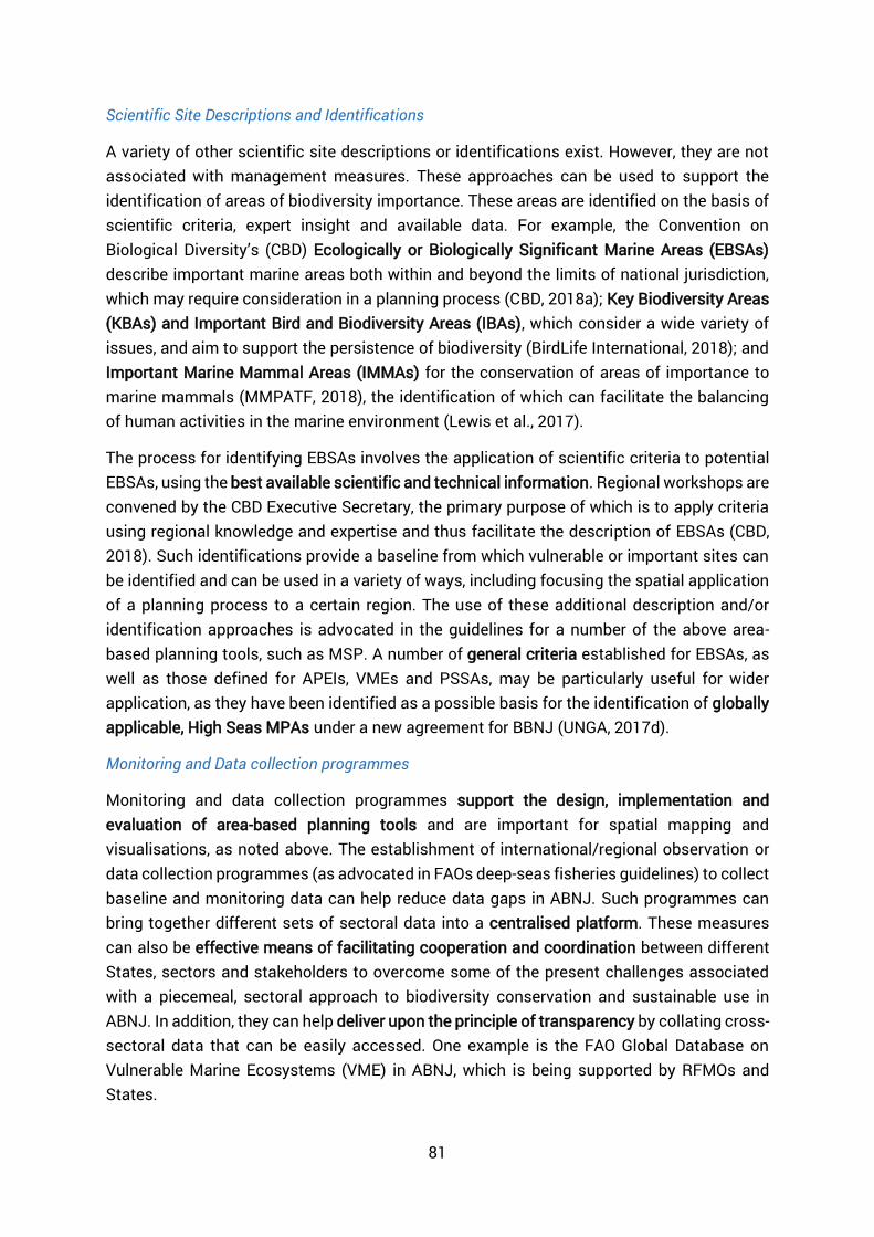
81
Scientific Site Descriptions and Identifications
A variety of other scientific site descriptions or identifications exist. However, they are not associated with management measures. These approaches can be used to support the identification of areas of biodiversity importance. These areas are identified on the basis of scientific criteria, expert insight and available data. For example, the Convention on Biological Diversity’s (CBD) Ecologically or Biologically Significant Marine Areas (EBSAs) describe important marine areas both within and beyond the limits of national jurisdiction, which may require consideration in a planning process (CBD, 2018a); Key Biodiversity Areas (KBAs) and Important Bird and Biodiversity Areas (IBAs), which consider a wide variety of issues, and aim to support the persistence of biodiversity (BirdLife International, 2018); and Important Marine Mammal Areas (IMMAs) for the conservation of areas of importance to marine mammals (MMPATF, 2018), the identification of which can facilitate the balancing of human activities in the marine environment (Lewis et al., 2017).
The process for identifying EBSAs involves the application of scientific criteria to potential EBSAs, using the best available scientific and technical information. Regional workshops are convened by the CBD Executive Secretary, the primary purpose of which is to apply criteria using regional knowledge and expertise and thus facilitate the description of EBSAs (CBD, 2018). Such identifications provide a baseline from which vulnerable or important sites can be identified and can be used in a variety of ways, including focusing the spatial application of a planning process to a certain region. The use of these additional description and/or identification approaches is advocated in the guidelines for a number of the above area-based planning tools, such as MSP. A number of general criteria established for EBSAs, as well as those defined for APEIs, VMEs and PSSAs, may be particularly useful for wider application, as they have been identified as a possible basis for the identification of globally applicable, High Seas MPAs under a new agreement for BBNJ (UNGA, 2017d).
Monitoring and Data collection programmes
Monitoring and data collection programmes support the design, implementation and evaluation of area-based planning tools and are important for spatial mapping and visualisations, as noted above. The establishment of international/regional observation or data collection programmes (as advocated in FAOs deep-seas fisheries guidelines) to collect baseline and monitoring data can help reduce data gaps in ABNJ. Such programmes can bring together different sets of sectoral data into a centralised platform. These measures can also be effective means of facilitating cooperation and coordination between different States, sectors and stakeholders to overcome some of the present challenges associated with a piecemeal, sectoral approach to biodiversity conservation and sustainable use in ABNJ. In addition, they can help deliver upon the principle of transparency by collating cross-sectoral data that can be easily accessed. One example is the FAO Global Database on Vulnerable Marine Ecosystems (VME) in ABNJ, which is being supported by RFMOs and States.

82
Valuation mapping and trade-off analysis
It is useful to undertake valuation mapping activities to support effective trade-off analyses to identify appropriate planning and management approaches for a particular area (Lester et al., 2013). However, such analyses and valuations can be difficult to undertake due to limited expertise and available data. With valuation, a common mechanism used to fill data gaps is to undertake benefits transfer, which is the use of values created in one location and extrapolated to another (Richardson et al., 2015). When studies have been undertaken within national jurisdiction it may not be suitable to use the process of benefits transfer. In addition, how the benefits or costs of the trade-offs or values could be judged in relation to each other at a global scale will require an immense communication effort. Therefore, until further information is available, it is likely that this approach will be difficult to apply in ABNJ.
Enforcement measures
In ABNJ, a challenge that has yet to be fully solved is the enforcement of effective area-based planning and associated management measures. At present, there are systems capable of recognising and tracking individual ship movements, for example Automatic Identification Systems (AIS). Whilst these systems can provide detailed information about the geographic location and operations of these vessels, there are practical limitations in identifying the activities occurring on-board. Additionally, there are jurisdictional complexities regarding how to address infringements on management measures, or how a vessel could be physically intercepted due to the potentially vast distances to cover and associated costs. Work on the development of, for example IUU registers in the RFMOs, could provide a basis for future cross-sectoral measures. Also, the FAO Port State Measures provides a mechanism for controlling a particular activity as the resources (fish in this instance) are landed32.
Education and Awareness Programmes
In order to support the effectiveness of area-based planning tools, education and awareness programmes could be established to facilitate communication between different actors within regions. These programmes would also help each actor to understand the needs and priorities of other actors, and the objectives of the area-based planning tool itself. For example, the OSPAR Management Guidelines encourage the provision of information on plans for general or specific education and awareness programmes to promote and support the protection and sustainable use of MPAs within the OSPAR region (OSPAR, 2003b, Article 4.2.8).
32 Information on the Port State Measures can be found on the FAO website.

83
9 Annex 2 Table 8- Area-based planning tool guidelines and frameworks used in this review, listed by tool.
Tool Organisation Year Full name Guidelines
Marine Spatial Planning (MSP)
IOC-UNESCO 2009 Marine Spatial Planning: a step-by-step approach toward ecosystem-based management
European Commission 2002 Recommendation of the European Parliament and of the Council of 30 May 2002 concerning the implementation of integrated coastal zone management in Europe (2002/413/EC)
European Commission 2014 Directive 2014/89/EU of the European Parliament and of the Council of 23 July 2014 establishing a framework for maritime spatial planning
HELCOM 2007 HELCOM Recommendation 28E/9 on the Development of Broad-Scale Marine Spatial Planning Principles in the Baltic Sea Area
Marine Protected Areas (MPAs)
IUCN 2008 Guidelines for Applying Protected Area Management Categories
IUCN 2012 Guidelines for Applying the IUCN Protected Area Management Categories to Marine Protected Areas
IUCN 2017 Large-Scale Marine Protected Areas
OSPAR 2003 Guidelines for the Identification and Selection of Marine Protected Areas in the OSPAR Maritime Area
OSPAR 2003 Guidelines for the Management of Marine Protected Areas in the OSPAR Maritime Area Particularly Sensitive Sea Areas (PSSAs)
International Maritime Organisation (IMO)
2005 Resolution A.982(24) Revised Guidelines for the Identification and Designation of Particularly Sensitive Sea Areas.
Areas of Particular Environmental Interest (APEIs)
International Seabed Authority (ISA)
2011 ISBA/17/LTC/7 - Environmental Management Plan for the Clarion-Clipperton Zone
International Seabed Authority (ISA)
2012 ISBA/18/C/22 – Decision of the Council relating to an environmental management plan for the Clarion-Clipperton Zone
Fisheries Closures relating to VMEs
Food and Agriculture Organisation of the United Nations (FAO)
2008 International Guidelines for the Management of Deep-Sea Fisheries in the High Seas

84
ABNJ DEEP SEAS PROJECT The Sustainable Fisheries Management and Biodiversity Conservation of Deep Sea Living Resources in Areas Beyond National Jurisdiction Project (ABNJ Deep Seas Project for short) is a five year project supported by the Global Environment Facility, and implemented jointly by the Food and Agriculture Organization of the United Nations, and the United Nations Environment Programme. The UNEP project component is executed though the UNEP World Conservation and Monitoring Centre.
The Project is designed to enhance sustainability in the use of deep-sea living resources and biodiversity conservation in the ABNJ through the systematic application of an ecosystem approach. It brings together over 20 partners who work on deep-sea fisheries and conservation issues in the ABNJ globally. The partnership includes regional organizations responsible for the management of deep-sea fisheries, Regional Seas Programmes, the fishing industry and international organizations.
The Project aims to:
Strengthen policy and legal frameworks for sustainable fisheries and biodiversity conservation in the ABNJ deep-seas;
Reduce adverse impacts on VMEs and enhanced conservation and management of components of EBSAs;
Improve planning and adaptive management for deep-sea fisheries in ABNJ; and develop and test methods for area‐based planning.
The ABNJ Deep Seas Project started in September 2015 and is one of four projects under the GEF Common Oceans Programme.
More information is available from www.commonoceans.org


