1 A Review of the 'Value Management Workshop Report' Pacific Highway Bulahdelah Upgrade Extracts from the Value Management Workshop Report are included A. Carrall Originally published via www March, 2003 The NSW Roads & Traffic Authority, in conjunction with PPK Environment & Infrastructure (now Parsons Brinkerhoff), conducted its Pacific Highway Bulahdelah Upgrade 'Value Management Workshop' (VMW) on 29th and 30th August, 2000. The outcome of the VMW was that, of the five published route options (A, B, C, D & E) and two additional routes (A/B & C1) of which the public had received no notification whatsoever, all groups present selected the highway relocation known as Option E as being appropriate for ‘progression to the next stage of development’ (Page 1 VMW Workshop Report) which was the presentation of all route options to the (then) Minister for Roads, Minister for Transport, Hon. Carl Scully with the recommendation that Option E should be the official Preferred Route for the Pacific Highway Bulahdelah Upgrade. On page 4 of the VMW Report it is stated : “There was unanimous agreement amongst the sub groups that Option E should go forward for further consideration and refinement. The rationale offered by the groups in support of the recommendation of Option E was that it:- • Satisfies road user and community criteria. • Minimises impact on community amenity, urban connectivity, and property acquisition • Is aesthetically pleasing • Does not divide the town • Maintains through travel at speed • Is not through town but provides a visual connection to Bulahdelah • Has an acceptable comparative road user BCR” [Note: As evidenced in the Initial Assessment table below, this was meant to incorporate shortest travel time and construction costs.] If taken at face value, the above sounds equitable and therefore credible. However,
Transcript
1
A Review of the 'Value Management Workshop Report' Pacific Highway Bulahdelah Upgrade
Extracts from the Value Management Workshop Report are included A. Carrall
Originally published via www March, 2003
The NSW Roads & Traffic Authority, in conjunction with PPK Environment & Infrastructure (now Parsons Brinkerhoff), conducted its Pacific Highway Bulahdelah Upgrade 'Value Management Workshop' (VMW) on 29th and 30th August, 2000.
The outcome of the VMW was that, of the five published route options (A, B, C, D & E) and two additional routes (A/B & C1) of which the public had received no notification whatsoever, all groups present selected the highway relocation known as Option E as being appropriate for ‘progression to the next stage of development’ (Page 1
VMW Workshop Report) which was the presentation of all route options to the (then) Minister for Roads, Minister for Transport, Hon. Carl Scully with the recommendation that Option E should be the official Preferred Route for the Pacific Highway Bulahdelah Upgrade.
On page 4 of the VMW Report it is stated:
“There was unanimous agreement amongst the sub groups that Option E should go forward for further consideration and refinement. The rationale offered by the groups in support of the recommendation of Option E was that it:-
• Satisfies road user and community criteria. • Minimises impact on community amenity, urban connectivity, and property
acquisition • Is aesthetically pleasing • Does not divide the town • Maintains through travel at speed • Is not through town but provides a visual connection to Bulahdelah • Has an acceptable comparative road user BCR” [Note: As evidenced in the
Initial Assessment table below, this was meant to incorporate shortest travel time and construction costs.]
If taken at face value, the above sounds equitable and therefore credible. However,
2
of the above seven ‘reasons’ for the groups’ support of the recommendation of Option E, five are questionable, with some of these being absolutely false and the remaining two ‘reasons’ (‘Does not divide the town’ and ‘Maintains through travel at speed’) are equally applicable to the western options (A and B).
Prior to this agreement being reached the following occurred:
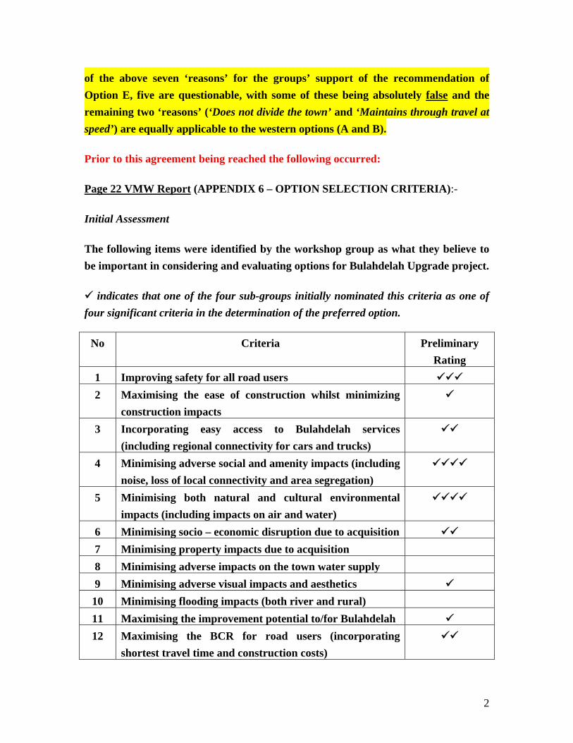
The following items were identified by the workshop group as what they believe to be important in considering and evaluating options for Bulahdelah Upgrade project.
indicates that one of the four sub-groups initially nominated this criteria as one of four significant criteria in the determination of the preferred option.
No Criteria Preliminary Rating
1 Improving safety for all road users 2 Maximising the ease of construction whilst minimizing
construction impacts
3 Incorporating easy access to Bulahdelah services (including regional connectivity for cars and trucks)
4 Minimising adverse social and amenity impacts (including noise, loss of local connectivity and area segregation)
5 Minimising both natural and cultural environmental impacts (including impacts on air and water)
6 Minimising socio – economic disruption due to acquisition 7 Minimising property impacts due to acquisition 8 Minimising adverse impacts on the town water supply 9 Minimising adverse visual impacts and aesthetics 10 Minimising flooding impacts (both river and rural) 11 Maximising the improvement potential to/for Bulahdelah 12 Maximising the BCR for road users (incorporating
shortest travel time and construction costs)
3
_________________________________________________
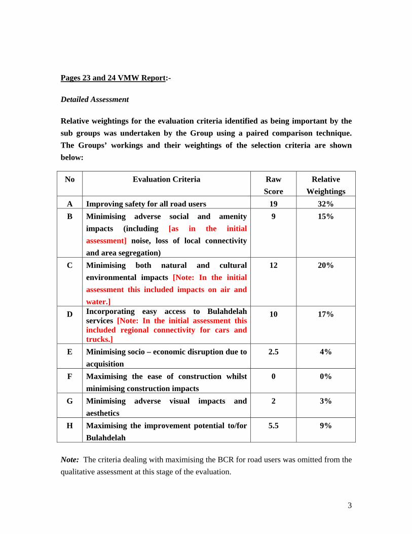
Pages 23 and 24 VMW Report:-
Detailed Assessment
Relative weightings for the evaluation criteria identified as being important by the sub groups was undertaken by the Group using a paired comparison technique. The Groups’ workings and their weightings of the selection criteria are shown below:
No Evaluation Criteria Raw Score
Relative Weightings
A Improving safety for all road users 19 32% B Minimising adverse social and amenity
impacts (including [as in the initial assessment] noise, loss of local connectivity and area segregation)
9 15%
C Minimising both natural and cultural environmental impacts [Note: In the initial assessment this included impacts on air and water.]
12 20%
D Incorporating easy access to Bulahdelah services [Note: In the initial assessment this included regional connectivity for cars and trucks.]
10 17%
E Minimising socio – economic disruption due to acquisition
2.5 4%
F Maximising the ease of construction whilst minimising construction impacts
0 0%
G Minimising adverse visual impacts and aesthetics
2 3%
H Maximising the improvement potential to/for Bulahdelah
5.5 9%
Note: The criteria dealing with maximising the BCR for road users was omitted from the qualitative assessment at this stage of the evaluation.
4
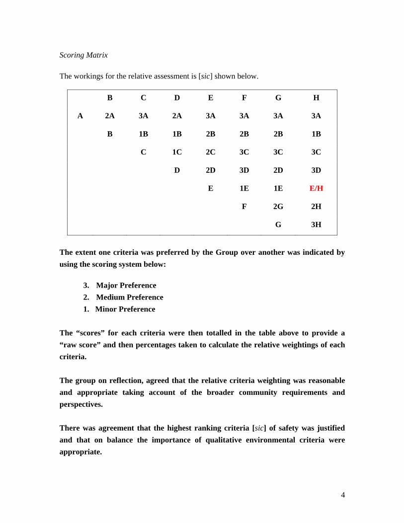
Scoring Matrix
The workings for the relative assessment is [sic] shown below.
B C D E F G H
A 2A 3A 2A 3A 3A 3A 3A
B 1B 1B 2B 2B 2B 1B
C 1C 2C 3C 3C 3C
D 2D 3D 2D 3D
E 1E 1E E/H
F 2G 2H
G 3H
The extent one criteria was preferred by the Group over another was indicated by using the scoring system below:
3. Major Preference 2. Medium Preference 1. Minor Preference
The “scores” for each criteria were then totalled in the table above to provide a “raw score” and then percentages taken to calculate the relative weightings of each criteria. The group on reflection, agreed that the relative criteria weighting was reasonable and appropriate taking account of the broader community requirements and perspectives. There was agreement that the highest ranking criteria [sic] of safety was justified and that on balance the importance of qualitative environmental criteria were appropriate.
5
The group were [sic] divided in their opinion as to whether the concerns of the business community were adequately acknowledged and reflected in the relative ratings but on balance believed the assessment was appropriate.
Summary
The weighting of criteria using the paired comparison methodology indicated improving safety for all road users as the most important criteria [sic] followed by minimising natural and cultural environmental impacts, incorporating ease of access to Bulahdelah and minimising adverse social and amenity impacts on the next level of importance and then maximising improvement potential to Bulahdelah, minimising social disruption due to acquisition and maximising the ease of construction as the least important criteria [sic].
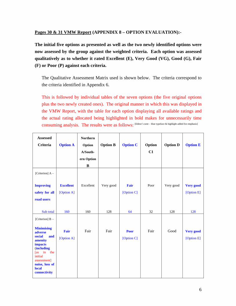
The initial five options as presented as well as the two newly identified options were now assessed by the group against the weighted criteria. Each option was assessed qualitatively as to whether it rated Excellent (E), Very Good (VG), Good (G), Fair (F) or Poor (P) against each criteria.
The Qualitative Assessment Matrix used is shown below. The criteria correspond to the criteria identified in Appendix 6.
This is followed by individual tables of the seven options (the five original options plus the two newly created ones). The original manner in which this was displayed in the VMW Report, with the table for each option displaying all available ratings and the actual rating allocated being highlighted in bold makes for unnecessarily time consuming analysis. The results were as follows: [Editor’s note – blue typeface & highlight added for emphasis]
Assessed
Criteria
Option A
Northern
Option
A/South-
ern Option
B
Option B
Option C
Option
C1
Option D
Option E
[Criterion] A –
Improving
safety for all
road users
Sub total
Excellent
[Option A]
160
Excellent
160
Very good
128
Fair
[Option C]
64
Poor
32
Very good
128
Very good
[Option E]
128
[Criterion] B –
Minimising adverse social and amenity impacts (including [as in the initial assessment] noise, loss of local connectivity
Fair
[Option A]
Fair
Fair
Poor
[Option C]
Fair
Good
Very good
[Option E]
7
and area segregation)
Sub total
30
30
30
15
30
45
60
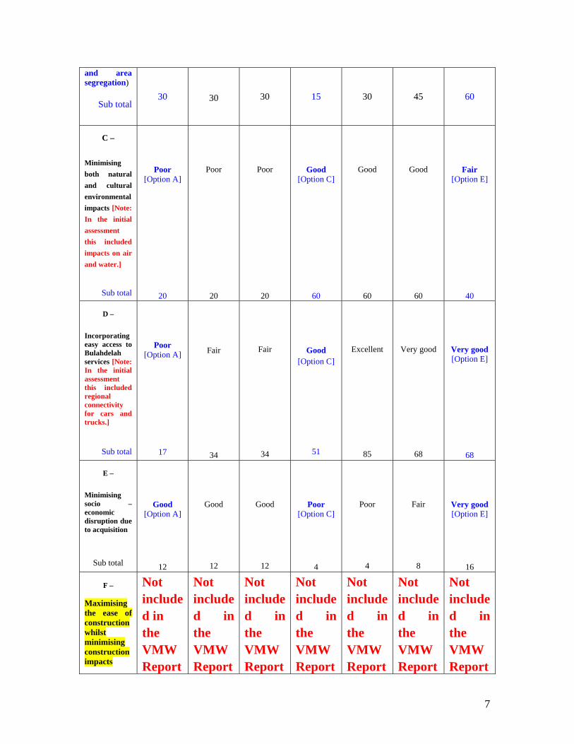
C –
Minimising both natural and cultural environmental impacts [Note: In the initial assessment this included impacts on air and water.]
Sub total
Poor [Option A]
20
Poor
20
Poor
20
Good [Option C]
60
Good
60
Good
60
Fair [Option E]
40
D –
Incorporating easy access to Bulahdelah services [Note: In the initial assessment this included regional connectivity for cars and trucks.]
Sub total
Poor [Option A]
17
Fair
34
Fair
34
Good [Option C]
51
Excellent
85
Very good
68
Very good [Option E]
68
E –
Minimising socio – economic disruption due to acquisition
Sub total
Good [Option A]
12
Good
12
Good
12
Poor [Option C]
4
Poor
4
Fair
8
Very good [Option E]
16
F –
Maximising the ease of construction whilst minimising construction impacts
Not included in the VMW Report
Not included in the VMW Report
Not included in the VMW Report
Not included in the VMW Report
Not included in the VMW Report
Not included in the VMW Report
Not included in the VMW Report
8
Sub total
Option Evaluation
-----
Option Evaluation
-----
Option Evaluation
-----
Option Evaluation
-----
Option Evaluation
-----
Option Evaluation
-----
Option Evaluation
-----
G –
Minimising adverse visual impacts and aesthetics
Sub total
Very good [Option A]
12
Very good
12
Fair
6
Poor [Option C]
3
Poor
3
Fair
6
Excellent [Option E]
15
H –
Maximising the
improvement potential
to/for Bulahdelah
Sub total
Maximising the improvemen
Ref. *1 (below)
Poor
9
Ref. *2 (below)
Good [Option C]
27
Good
27
Very good
36
Excellent [Option E]
45
*1. The allocated rating for Option A – H (Maximising the improvement potential to/for
Bulahdelah) is not highlighted in bold in the VMW Report. However, the rating sub total is 9 –
indicating that Option A was allocated ‘poor’ regarding this particular criterion.
*2. In the VMW Report the allocated rating for Option B – H (Maximising the improvement
potential to/for Bulahdelah) is highlighted in bold as being ‘F’ (Fair). However, the rating sub total
is 9 – as is the rating sub total for Northern Option A/Southern Option B which was rated ‘P’ (Poor).
_____________________________________
9
Upon review it is clear that the above ‘Option Evaluation’ included absurdities and fabrications which corrupted the findings of the Value Management Workshop.
(As the two options introduced at the VMW, Northern Option A/Southern Option B and Option C1 are variations of Options A & B and C respectively and Option C and that part of Option D which does not encroach upon the Alum Mountain would follow the route of the current highway, for the purpose of brevity they are not included in the following review of the ‘Option Evaluation’.)
Review of the ‘Option Evaluation’
B – Minimising adverse social and amenity impacts (including [as in the initial assessment] noise, loss of local connectivity and area segregation (For which Options A and B received an assessment of ‘Fair’ – sub total 30 – and Option E received an assessment of ‘Very Good’ – sub total 60.) As substantiated by the following, the assessments of Options A, B and E in section B – Minimising adverse social and amenity impacts (including noise, loss of local connectivity and area segregation) – were incorrect. Options A and B should have received an assessment of ‘Very Good’ (60), Option E should have been assessed as ‘Poor’ (15). ‘Adverse social and amenity impacts’:
Options A and B would have no adverse social and amenity impacts whatsoever. There are no community amenities to the west of the township of Bulahdelah.
Option E would have adverse social and amenity impacts of profound proportions. Option E would be located in a cutting up to 25 metres in depth through the mid-slopes of the Alum Mountain, Bulahdelah, the largest deposit of alum stone (alunite) in the Southern Hemisphere. In the early nineteen eighties the Alum Mountain was recorded by NSW State Forests as attracting seven thousand visitors per annum. The Alum Mountain Park (which at the time of the VMW was to be totally eradicated by Option E and – as at March, 2003 – would still be largely eradicated by this route) is an amenity used by many members of both the local and broader community, including road users, for the
10
purpose of respite.
‘Noise’:
VMW Report – page 17:
“3.5 Overview of Noise Assessment – George Jenner, Wilkinson Murray
The results of a detailed noise assessment was [sic] presented to the Group.
The analysis in summary identified Options A, B & E as having the least impact due to noise with options C & D being significantly worse for noise.”
The results of the ‘detailed noise assessment’ were not published in the VMW Report. From Wilkinson Murray’s ‘summary’ of their ‘detailed noise assessment’, the assessment failed to take into account the following:
Option A is furthest from the township and few properties are in close proximity to this option. Option B is the next closest route to the township and few properties are in close proximity to this option. Option E is the closest of these three options to the residential area, including schools.
These three options should not have been rated equally. Option A would have the least impact due to noise; Option B would have a higher noise impact; and of these three options Option E would have the highest noise impact.
Additionally, noise pollution created by Option E would severely and adversely impact upon an area which currently attracts thousands of visitors per annum.
‘Loss of local connectivity’ and ‘area segregation’:
Options A and B would not cause loss of either local connectivity or area segregation as there are no community use facilities to the west of the
11
township. The areas where Options A and B would be located are not used by the general community – the greater part is inaccessible to the public.
Option E would cause both ‘loss of local connectivity’ to and ‘segregation’ from [actually annihilation of] an area which is an intrinsic part of Bulahdelah’s history, heritage and culture and is currently accessed by thousands of visitors per annum.
Option E would ‘result in the imposition of a modern linear road development across the mine site complex, and as such would have a significant impact on the heritage and broader landscape context values’. [Heritage Assessment of the Bulahdelah Alunite Mine Site – A Cultural Heritage Assessment with Reference to the
Proposed Bulahdelah Pacific Highway Upgrade Route Option E – Navin Officer Heritage Consultants – June 2001]
[Option E would, in fact, destroy that the mine site complex, eradicating some of and mutilating all of the mining heritage area in and near the Alum Mountain Park.]
Option E, by restricting access to the township (‘area segregation’) from the Alum Mountain’s upper regions, would cause time delays for bush walkers and others needing to physically access emergency services.
C – Minimising both natural and cultural environmental impacts [Note: In the initial assessment this included impacts on air and water.]
(For which Options A and B received an assessment of ‘Poor’ – sub total 20 – and Option E received an assessment of ‘Fair’ – sub total 40.) As substantiated by the following, the assessments of Options A, B and E in section C – Minimising both natural and cultural environmental impacts (which, in the initial assessment included impacts on air and water) were false. Options A and B should have received an assessment of ‘Fair’ (40) and Option E should have been assessed as ‘Poor’ (20). The 180 metres plus above sea level area of the Alum Mountain has a Commonwealth heritage ‘protection’ listing due to its unique geographical features. The mountain was recorded by NSW State Forests as attracting seven thousand visitors per annum in the early nineteen eighties. The areas which would be destroyed by Option E are:
12
• The Alum Mountain Park. An intrinsic part of Bulahdelah’s history, heritage and culture and currently a popular respite area for both residents and travellers. (At the time of the VMW the entire Alum Mountain Park was to be eradicated by Option E. Currently – March, 2003 – Option E would eradicate the eastern section of the park – the sports recreation area – and at least one third of the park’s western section.)
• The Alum Mountain Park currently delineates and conserves the site of the former mine factory, the only location in Australia where the extraction of alum from alum stone (alunite) was carried out on site.
• Mining history and heritage which is of not only local but of State and National significance. ['The Bulahdelah (Alum Mountain) Alunite Mine Site-Complex Report’ commissioned by the RTA
through PPK.] • All of the Alum Mountain's lower walking trails. • A wealth of native flora including one of the world’s only three species of
underground orchids, the rarely found, non-cultivable and therefore non ‘recoverable’ Rhizanthella slateri (Eastern Underground Orchid); a species which was not only first discovered on the Alum Mountain, Bulahdelah, in 1931 but at the time of the Value Management Workshop had been found four times in the area which would be excavated for Option E.
(Rhizanthella slateri is listed in the 'Review of Environmental Factors' – REF – as being in the path of Option E. On 16th May and 23rd June, 2002 two further finds of this species were made on the lower slopes of the Alum Mountain.)
• Old growth trees including a white mahogany which has been identified as being between five to seven hundred years old.
‘Minimising natural environmental impacts’:
No authenticated and documented finds of the non-cultivable plant species Rhizanthella slateri have been made to the west of Bulahdelah (the Options A and B area). Option E would be located in an area which has long been renowned for its huge variety of Australian native orchids; including, since 1931, when the species was first discovered – on the lower slopes of the Alum Mountain,
13
Bulahdelah – one of the world’s only two species of underground orchids, the non-cultivable Rhizanthella slateri.
‘Minimising cultural environmental impacts’:
Options A and B would have no cultural environmental impacts whatsoever. The areas where Options A and B would be located are not used by the general community – the greater part is inaccessible to the public. Options A and B would not impact upon any non-indigenous heritage items whatsoever. There are no non-indigenous heritage items in these areas. Options A and B would be located in broad corridors with ample room for any indigenous heritage items to be avoided by means of realignment of these routes.
Option E would adversely impact upon an area of high cultural significance – both historic and present day. Option E would adversely impact upon mining history of high significance. Option E would be located in an extremely narrow corridor. There is no room for realignment of this route sufficient to avoid impacts upon cultural heritage.
‘Air and water’:
Options A and B would – as would all other routes – include river crossings. However, Options A and B would ‘not contribute to contribute to increased flooding conditions in Bulahdelah’ [VMW Report – pages 25 and 26.]
Option E ‘Has a potential adverse impact on flood levels’ and ‘has a potential adverse impact on flood plain/swamp’. [VMW Report – page 29.]
Option E – unlike all other routes – has both acid sulphate soils and ‘Acid generating rock’ which ‘impacts on surface water quality’. [Pacific Highway Upgrade –
14
Bulahdelah Review of Environmental Factors (REF) – page 16.]
On coming into contact with water, the alum content of alum stone (alunite) hydrolises to form sulphuric acid. During construction, Option E would have a raw cutting. The water runoff from the raw cutting, 500 metres of which would be up to 25 metres deep, would be toxic for fish and other marine life. Option E is also the closest route to the Myall Lakes. Drinking water is filtered, air is not. Option E would be located close to a large percentage of Bulahdelah residences and would be near mass schooling institutions. Options A and B would not. Option E – both during and after construction – would create adverse impacts on air quality for a large percentage of citizens – including the hundreds of children who attend Bulahdelah’s mass schooling institutions. Options A and B would not. [Editor’s note August, 2010: It has now been found that the volcanic rock dust generated during construction would contain both sulphuric acid and silica. Sulphuric acid is carcinogenic. Silica-bearing rock dust causes cancer and silicosis. Silicosis is a terminal lung disease. Diesel exhaust particulate matter is also carcinogenic. ‘5 million litres of diesel fuel would be used during construction …’. (EIS Volume 6 Technical Papers 13 to 16 Appendix C Fuel Usage
Assumptions and Calculations)]
D – Incorporating easy access to Bulahdelah services [Note: In the initial assessment this included regional connectivity for cars and trucks.]
(For which Option A received an assessment of ‘Poor’ – sub total 17; Option B received an assessment of ‘Fair’ – sub total 34; and Option E received an assessment of ‘Very good’ – sub total 68.) As substantiated by the following, the assessments of Options A, B and E in section
15
D – Incorporating easy access to Bulahdelah services were incorrect. Option A should have received an assessment of ‘Very good’ (68); Option B an assessment of ‘Good’ (51); and Option E should have been assessed as ‘Poor’ (17). At the time of the VMW:
• Option A was to have a ‘half interchange at Booral Road [the road to Stroud] and full interchange at Wooton Road’ [the northern end of the intended new section of highway]. [VMW Report – page 11.]
• Option B was to have ‘a threequarter [sic] interchange with the existing highway north of Booral Road and half interchange north of Lee Street’. [VMW Report – page 11.]
• Option E was to have ‘a full interchange at Jackson Street, to connect to existing highway and Alum Mountain’. [VMW Report – page 13.]
Option A’s ‘half interchange’ and ‘full interchange’ would provide easier access to/from Bulahdelah than Option B’s ‘threequarter [sic] and ‘half’ interchanges. Yet, regarding ‘incorporating easy access to Bulahdelah services’, Option A was assessed by VMW participants as ‘Poor’ (17) and the inferior Option B was assessed as ‘Fair’ (34). Both of these options, however, would leave the road network of the township as is; thereby providing travellers with easy access to those businesses they wished to utilise. Both of these options would also provide through-travellers with direct access into Bulahdelah and the opportunity to re-access the new section of highway at a point closer to their next destination (decreased travelling kilometers). Option E would alter the road network of Bulahdelah, thereby creating a situation where travellers entering Bulahdelah [Ed: from the now discontinued central interchange] would have to search for the businesses they wished to access. Option E’s one ‘full interchange’ would have entailed both northbound and southbound road users having to re-access the new section of highway at the point at which they had left it (increased travelling kilometers). [Editor’s note: the idea of a central interchange for Option E was abandoned after the Value Management Workshop.]
16
E – Minimising socio – economic disruption due to acquisition
(For which Options A and B received an assessment of ‘Good’ – sub total 12 and Option E received an assessment of ‘Very good’ – sub total 16.) As substantiated by the following, the assessments of Options A, B and E in section E – Minimising socio-economic disruption due to acquisition were incorrect. Options A and B should have received an assessment of ‘Very good’ (16) and Option E should have been assessed as ‘Poor’ (4). * 'Approximate number of properties affected' by each option *In RTA terminology the word 'affected' applies only to those properties which would be 'acquired' by the RTA. [Editor’s note August, 2010: The RTA’s corrupt application of ‘affected’ does not include structural damages to property, air or noise pollution or any other adverse effects which would be recognised and acknowledged as such by NORMAL people.] Following are the 'Approximate number of properties affected' by each option [VMW
Report – pages 11, 12 & 13]
• Option A - 19 properties, 85 hectares • Option B - 19 properties, 84 hectares • Option C - 55 properties, 32 hectares, including 17 houses, 5 businesses, 1
community use • Option D - 45 properties, 38 hectares including 14 houses, 2 businesses, 1
community use • Option E - 20 properties, 63 hectares including 1 house, 1 community use
Options A and B would ‘affect’ no houses (i.e. homes i.e. families). Options A and B would ‘affect’ no 'community use' facilities. Option E would ‘affect’ one house and one 'community use'. And the 'community use' facility which would be ‘affected’ by Option E is the Alum Mountain Park – a major feature of a unique eco-tourism, recreational and educational area which attracts
17
thousands of visitors per annum. (At the time of the VMW the Alum Mountain Park was to be totally eradicated by Option E. In March, 2003 – after some four or five 'realignments' of this route – the Alum Mountain Park would still lose its sports recreation area, its footbridge, its historical mullock heaps and other mining heritage, much of the western section of the park, nearby walking trails and easily viewable flora and fauna.)
F – Maximising the ease of construction whilst minimising construction impacts
• This was not included in the VMW Report Option Evaluation. [Editor’s note: this is where the existent landslide/s, the hazards of further landslides, boulder falls, batter collapse, acid sulphate rock dusts, silica-bearing rock dusts, blasting, evacuations, and potential vibration damages to privately and publicly owned properties (from a range of vibration-causing excavation activities) should have been evaluated.] However, on page 19 of the VMW Report it is stated:
3.8 General Comments Comments made by participants in an open forum at the end of the formal presentations are summarised below:- Construction impacts on noise, air and water quality will vary depending on the option. Option C will involve extensive traffic switching during construction. This activity has some safety implications. User delay costs for the respective options during construction are:-
• Option A $348000 • Option B $583000 • Option C $6300000 • Option D $5100000 • Option E $650000
G – Minimising adverse visual impacts and aesthetics
(For which Option A received an assessment of ‘Very good’ – sub total 12; Option B received ‘Fair’ – sub total 6; and Option E received an assessment of ‘Excellent’ –
18
sub total 15.) As substantiated by the following, the assessments of Options A, B and E in section G – Minimising adverse visual impacts and aesthetics were false. Option A should have received an assessment of ‘Excellent’ (15); Option B an assessment of ‘Very good’ (12) and Option E should have been assessed as ‘Poor’ (3). Option A would be located in an area which is not an intrinsic part of Bulahdelah’s aesthetics and is at a sufficient distance from the township to avoid adversely impacting upon the view from same. Option B would curve towards the township at its northern and southern ends and those sections of Option B would be visible from the township. Option E: • Would be located in an up to 25 metres deep excavation (cutting) into and along
the mid-slopes of a mountain of World Heritage value. • Would maximise adverse impacts – the Alum Mountain is Bulahdelah’s
principal aesthetic feature. • Would totally eradicate the aesthetics of that area by replacing them with a
highway, batters and – due to the massive excavation which would take place – a void where, looking from current ground level, picturesque bushland which attracts and is admired by many visitors is located.
H – Maximising the improvement potential to/for Bulahdelah
(For which Option A an assessment of what is presumably ‘Poor’ – sub total 9; Option B received ‘Fair’ – yet was given the sub total for ‘Poor’ 9; and Option E received an assessment of ‘Excellent’ – sub total 45.) As substantiated by the following, the assessments of Options A, B and E in section G – Maximising the improvement potential to/for Bulahdelah were false. Options A and B should have received an assessment of ‘Excellent’ (45) and Option E should have been assessed as ‘Poor’ (9).
19
All options bar Options A and [if correct that B’s northern interchange would be ‘north of Lee Street’] B would adversely impact upon Bulahdelah’s road network, thereby adversely impacting upon: inhabitants, including hospital and nursing home patients and children institutionalised in schools. Property and property values would also be impacted by Options C, D and E. Option E would also be likely to increase flood levels. [VMW Report – page 29.]
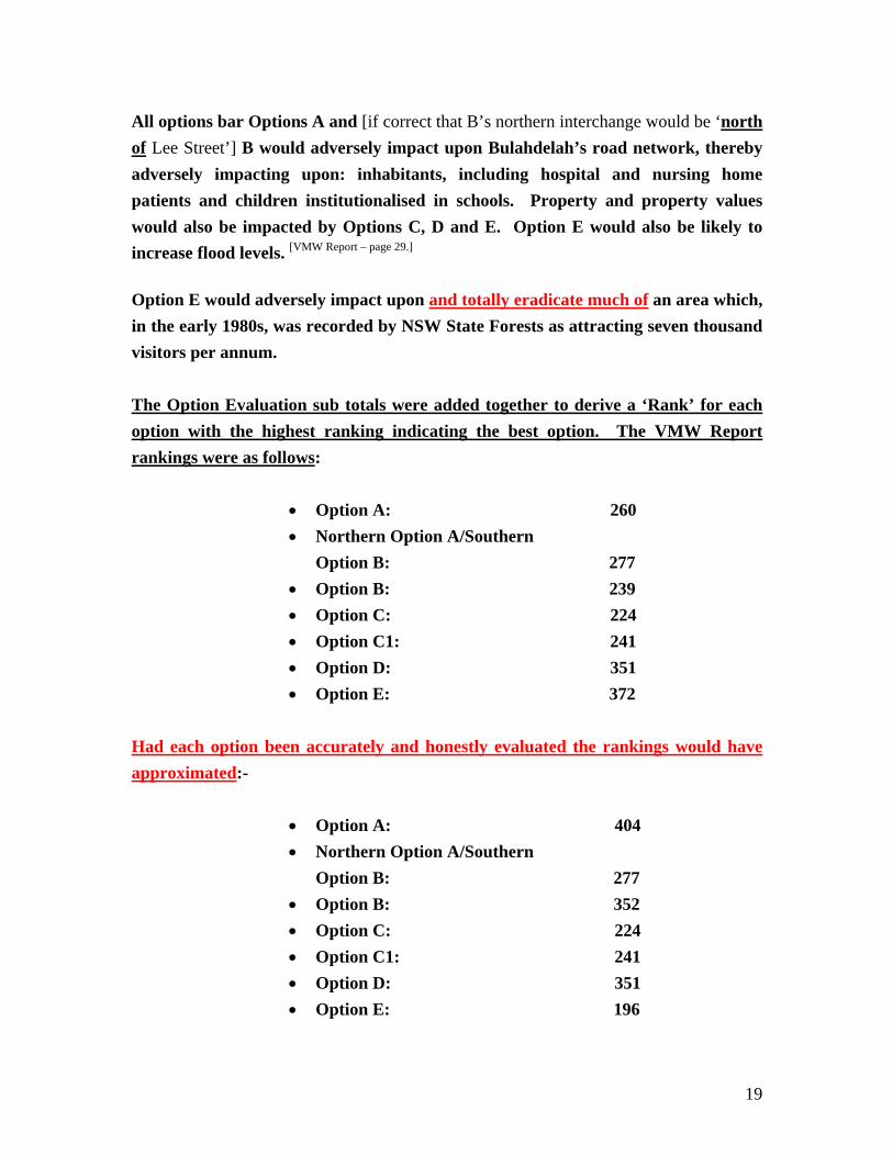
Option E would adversely impact upon and totally eradicate much of an area which, in the early 1980s, was recorded by NSW State Forests as attracting seven thousand visitors per annum. The Option Evaluation sub totals were added together to derive a ‘Rank’ for each option with the highest ranking indicating the best option. The VMW Report rankings were as follows:
The Alum Mountain Park consists of two sections, the eastern section being the sports recreation area. After several ‘realignments’ of Option E, the most recent being some twenty metres higher up the base of the Alum Mountain, the sports recreation of the Alum Mountain Park (in March, 2003) is in the centre of the most recent ‘realignment’ of this route - as is mining heritage of unique [National and International] heritage value. This was also the case when, in the RTA document, ‘Bulahdelah Upgrade’ Newsletter 4 of August, 2002, it was stated, “Proposed highway alignment shifted into power easement to avoid Bulahdelah Mountain [sic – i.e. the Alum Mountain is the name by which this mountain is generally known] picnic ground [the Alum Mountain Park – not merely a ‘picnic ground’] and historical areas.” And despite the fact that Option E would be located in an up to 25 metres deep excavation (cutting) with a conservatively estimated minimum overall width (including batters) of 100 metres through the mid-slopes of Bulahdelah’s iconic mountain, on the RTA, PB [Parsons Brinkerhoff] Bulahdelah Upgrade page at: http://www.pb.com.au/bulahdelah/html/eis_studies.html [Editor’s note: this URL is now obsolete] is the fraudulent statement, “The proposed highway [Option E] will be winding its way around the base of this [the Alum] mountain.” Based upon the above misleading statements, it is not surprising that one of the (only) three VMW participants who were nominated to ‘represent’ the community of Bulahdelah has now spoken out publicly against the manner in which the VMW was conducted and claims that participants were, “Hoodwinked.” Absurdities and fabrications regarding Option E were carried through from the Initial Option Assessment to the Option Assessment. The Value Management process was corrupt.
_____________________________________ ‘Initial Option Assessment’ At the VMW an ‘Initial Option Assessment’ was made by ‘sub groups’ of participants. On pages 25 to 29 of the VMW Report, under the inexpert headings ‘What’s good is that it’ and ‘What’s not so good is that it’, the sub groups ‘reviewed’ the five route options. Following are extracts from this section of the VMW Report. It is noteworthy that, rather than following, where possible, a standard procedure for each of the proposed routes, each sub group created (or was supplied with) an uncoordinated list of advantages and disadvantages for each of the options. But firstly the ‘project costs in 2006’:-
21
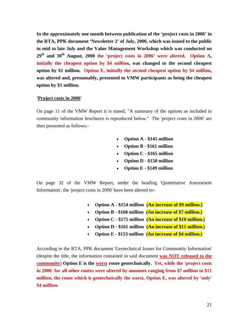
In the approximately one month between publication of the ‘project costs in 2006’ in the RTA, PPK document ‘Newsletter 2’ of July, 2000, which was issued to the public in mid to late July and the Value Management Workshop which was conducted on 29th and 30th August, 2000 the ‘project costs in 2006’ were altered. Option A, initially the cheapest option by $4 million, was changed to the second cheapest option by $1 million. Option E, initially the second cheapest option by $4 million, was altered and, presumably, presented to VMW participants as being the cheapest option by $1 million.
'Project costs in 2006'
On page 11 of the VMW Report it is stated, "A summary of the options as included in community information brochures is reproduced below." The 'project costs in 2006' are then presented as follows:-
• Option A - $145 million • Option B - $161 million • Option C - $165 million • Option D - $150 million • Option E - $149 million
On page 32 of the VMW Report, under the heading 'Quantitative Assessment Information', the 'project costs in 2006' have been altered to:-
• Option A - $154 million (An increase of $9 million.) • Option B - $168 million (An increase of $7 million.) • Option C - $175 million (An increase of $10 million.) • Option D - $161 million (An increase of $11 million.) • Option E - $153 million (An increase of $4 million.)
According to the RTA, PPK document 'Geotechnical Issues for Community Information' (despite the title, the information contained in said document was NOT released to the community) Option E is the worst route geotechnically. Yet, while the 'project costs in 2006' for all other routes were altered by amounts ranging from $7 million to $11 million, the route which is geotechnically the worst, Option E, was altered by 'only' $4 million.
22
Page 25 – VMW Report:- Appendix 7 – INITIAL OPTION ASSESSMENT An initial basis for reviewing the five identified options, sub groups were requested to review each of the options and identify:-
• What they believed to be good about the option • What they believed to be not so good about the option • How the option could be improved
The sub groups response [sic] are outlined below:- [Again for the purpose of brevity, only the responses to Options A, B and E are included.] Option A What’s good is that it [Option A]:-
• Is a low construction cost option • Has low impact on urban properties • Provides good horizontal and vertical alignment • Is geotechnically feasible although some soft soil treatments will be required • Minimises noise impact on residential areas • Integrates the urban areas and minimises impacts on residential areas • Maintains connectivity between the urban area and Alum Mountain • Enables the provision of an integrated interchange at the northern end • Only adversely affects a small number of rural residents from noise • Will not contribute to increased flooding conditions in Bulahdelah • Separates local and through traffic • Retains existing heavy vehicle movement paths in town • Does not restrict physical expansion of the town • Does not impact on the existing town utilities and infrastructure • Will have a low impact on road users and town community during construction • Enables easy access for emergency services • Enhances cycling and pedestrian movements in town • Provides greater opportunity for improving the amenity within the town centre
23
What’s not so good is that it [Option A]:- • [*A1.] Is the longest route and has the highest vehicle operating costs • Passes through ecologically sensitive habitats • Crosses river systems upstream of the town water supply storage • Dose [sic] not allow Bulahdelah to be readily visible from the approaches • [*A2.] Has a detrimental impact on the town and highway businesses • [*A3.] Does not utilise Fry’s Creek crossing • Traverses and impacts three major water courses • Creates a new barrier to wildlife corridors • [*A4.] Impacts rural property • Impact on the substation at Booral Road • [*A5.] Impacts large areas with predicted moderate to high archaeological
sensitivity • [*A6.] Reduces the viability of Bulahdelah as a service town • Potential soft soil issue • Potential for higher cost implications due to high environmental impact and the
likely need for additional underpasses and compensatory habitat.
[*A1.] ‘Is the longest route and has the highest vehicle operating costs’: On pages 11 to 13 of the VMW Report the length of the options were stated as being: Option A – 9.8 kilometres Option B – 9.6 kilometres Option C – 8.3 kilometres Option D – 8.2 kilometres Option E – 8.7 kilometres Based upon the length figures presented to VMW participants (to date – March, 2003 – no documentation has been provided to the community as to which starting and finishing points were used by the RTA/PPK to measure the length of each option), Option A is indeed the longest route and is 1.1 kilometres longer than Option E. However, ‘realignment’ of Option A could decrease its length.
[Editor’s note August, 2010: The criterion ‘A’ (Improving safety for all road users) assessment result for Option A was ‘Excellent’. Therefore, Option A would have the lowest traffic-flow related vehicle operating costs.]
Road User Delay Costs during Construction are listed on page 19 of the VMW
24
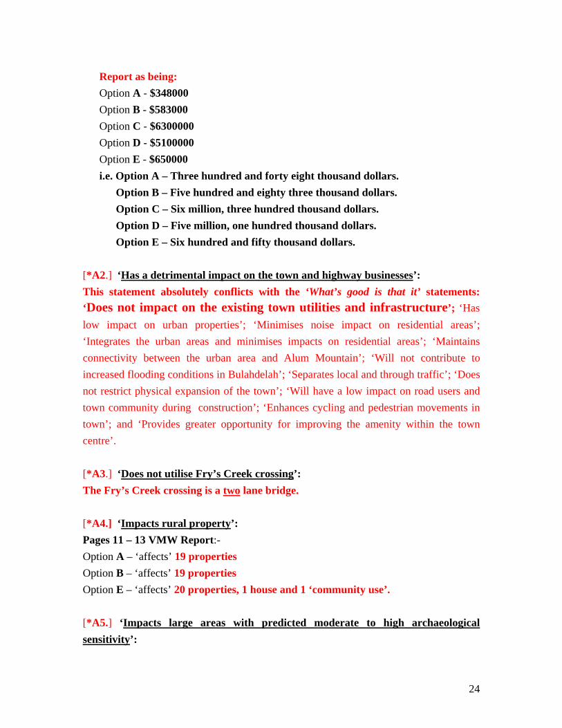
Report as being: Option A - $348000 Option B - $583000 Option C - $6300000 Option D - $5100000 Option E - $650000 i.e. Option A – Three hundred and forty eight thousand dollars.
Option B – Five hundred and eighty three thousand dollars. Option C – Six million, three hundred thousand dollars. Option D – Five million, one hundred thousand dollars. Option E – Six hundred and fifty thousand dollars.
[*A2.] ‘Has a detrimental impact on the town and highway businesses’: This statement absolutely conflicts with the ‘What’s good is that it’ statements: ‘Does not impact on the existing town utilities and infrastructure’; ‘Has low impact on urban properties’; ‘Minimises noise impact on residential areas’; ‘Integrates the urban areas and minimises impacts on residential areas’; ‘Maintains connectivity between the urban area and Alum Mountain’; ‘Will not contribute to increased flooding conditions in Bulahdelah’; ‘Separates local and through traffic’; ‘Does not restrict physical expansion of the town’; ‘Will have a low impact on road users and town community during construction’; ‘Enhances cycling and pedestrian movements in town’; and ‘Provides greater opportunity for improving the amenity within the town centre’. [*A3.] ‘Does not utilise Fry’s Creek crossing’: The Fry’s Creek crossing is a two lane bridge. [*A4.] ‘Impacts rural property’: Pages 11 – 13 VMW Report:- Option A – ‘affects’ 19 properties Option B – ‘affects’ 19 properties Option E – ‘affects’ 20 properties, 1 house and 1 ‘community use’. [*A5.] ‘Impacts large areas with predicted moderate to high archaeological sensitivity’:
25
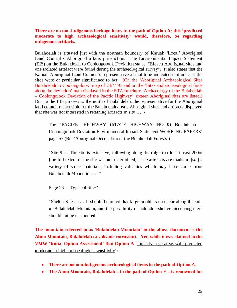
There are no non-indigenous heritage items in the path of Option A; this ‘predicted moderate to high archaeological sensitivity’ would, therefore, be regarding indigenous artifacts. Bulahdelah is situated just with the northern boundary of Karuah ‘Local’ Aboriginal Land Council’s Aboriginal affairs jurisdiction. The Environmental Impact Statement (EIS) on the Bulahdelah to Coolongolook Deviation states, “Eleven Aboriginal sites and one isolated artefact were found during the archaeological survey”. It also states that the Karuah Aboriginal Land Council’s representative at that time indicated that none of the sites were of particular significance to her. (On the ‘Aboriginal Archaeological Sites Bulahdelah to Coolongolook’ map of 24/4/’97 and on the ‘Sites and archaeological finds along the deviation’ map displayed in the RTA brochure ‘Archaeology of the Bulahdelah – Coolongolook Deviation of the Pacific Highway’ sixteen Aboriginal sites are listed.) During the EIS process to the north of Bulahdelah, the representative for the Aboriginal land council responsible for the Bulahdelah area’s Aboriginal sites and artifacts displayed that she was not interested in retaining artifacts in situ … :-
The ‘PACIFIC HIGHWAY (STATE HIGHWAY NO.10) Bulahdelah – Coolongolook Deviation Environmental Impact Statement WORKING PAPERS’ page 52 (Re. ‘Aboriginal Occupation of the Bulahdelah Forests’): “Site 9 … The site is extensive, following along the ridge top for at least 200m [the full extent of the site was not determined]. The artefacts are made on [sic] a variety of stone materials, including volcanics which may have come from Bulahdelah Mountain. … .” Page 53 – ‘Types of Sites’: “Shelter Sites – … It should be noted that large boulders do occur along the side of Bulahdelah Mountain, and the possibility of habitable shelters occurring there should not be discounted.”
The mountain referred to as ‘Bulahdelah Mountain’ in the above document is the Alum Mountain, Bulahdelah (a volcanic extrusion). Yet, while it was claimed in the VMW ‘Initial Option Assessment’ that Option A ‘Impacts large areas with predicted moderate to high archaeological sensitivity’:
• There are no non-indigenous archaeological items in the path of Option A. • The Alum Mountain, Bulahdelah – in the path of Option E – is renowned for
26
its mining history (high archaeological sensitivity). Yet no mention of this was made in the VMW ‘Initial Option Assessment’ of Option E.
• The RTA had record of the fact that the Alum Mountain, Bulahdelah – in the path of Option E – was highly likely to be of indigenous significance. Yet no mention of this was made in the VMW ‘Initial Option Assessment’ of Option E.
[*A6.] ‘Reduces the viability of Bulahdelah as a service town’: This statement absolutely conflicts with the ‘What’s good is that it’ statement ‘Does not impact on the existing town utilities and infrastructure’. Option B What’s good is that it [Option B]:-
• Enables Bulahdelah to be viewed from the southern approach making drivers aware of town facilities
• Will have low noise impacts on residential areas • Integrates urban areas and Alum Mountain [Editor’s note: Already ‘integrated’
– THE ALUM MOUNTAIN IS NOT AT A DISTANCE FROM THE TOWN – a large part of the residential area – including the ‘urban’ shopping centre – is located on the western foot of the Alum Mountain.]
• [*B1.] Will have low road user delays during construction • Is geotechnically feasible although some soft soil treatments will be required • Retains heavy vehicle traffic paths in town • [*B2.] Uses Fry’s Creek improvements • Only affects a small number of residents due to noise • Will not contribute to increased flooding conditions in Bulahdelah • Separates local and through traffic • Does not impact on the existing town utilities and infrastructure • Enables easy access for emergency services • Enhances cycling and pedestrian movements in town • Provides greater opportunity for improving the amenity within the town centre
What’s not so good is that it [Option B]:-
• [*B3.] Is the second longest route • Passes through the Myall and Crawford River floodplains
27
• [*B4.] The industrial area is visible from the north • Passes through ecologically sensitive habitats • Is upstream of the town water supply source • [*B5.] Has a potential detrimental impact on the town and highway business • [*B6.] Has higher vehicle operating costs (similar to Option A) • Will require a major excavation through variable geology and will require
additional stabilisation works • Has possible serious implications of a fault line on the bridge design • Has potential adverse flooding impacts on Bulahdelah • Has soft soil issues that will need to be managed • [*B7.] Has a higher risk of acid sulphate soil issues • [*B8.] Will adversely impact on new noise receivers in north west urban area • Restricts urban expansion to the north west • Presents new barriers to wild life corridors • [*B9.] Has potential significant impacts on vegetation and archaeological deposits
[*B1.] ‘Will have low road user delays during construction’:
Road User Delay Costs during Construction are listed on page 19 of the VMW Report as being: Option A - $348000 Option B - $583000 Option C - $6300000 Option D - $5100000 Option E - $650000 i.e. Option A – Three hundred and forty eight thousand dollars.
Option B – Five hundred and eighty three thousand dollars. Option C – Six million, three hundred thousand dollars. Option D – Five million, one hundred thousand dollars. Option E – Six hundred and fifty thousand dollars.
The Road User Delay Costs for Option B were recorded as being two hundred and thirty five thousand dollars more than those for Option A. [*B2.] ‘Uses Fry’s Creek improvements’: The Fry’s Creek crossing is a two lane bridge. [*B3.] ‘Is the second longest route’:
28
On pages 11 to 13 of the VMW Report the length of the options were stated as being: Option A – 9.8 kilometres Option B – 9.6 kilometres Option C – 8.3 kilometres Option D – 8.2 kilometres Option E – 8.7 kilometres (To date – March, 2003 – no documentation has been provided to the community as to which starting and finishing points were used by the RTA/PPK to measure the length of each option.)
[*B4.] ‘The industrial area is visible from the north’: ‘Industrial area’! – A couple of timber mills, a couple of chicken sheds, a piggery and a rubbish dump! All of which would be passed by – by most motorists – at a speed of 110 kilometres per hour. [*B5.] ‘Has a potential detrimental impact on the town and highway business’: This statement absolutely conflicts with the ‘What’s good is that it’ statements: ‘Does not impact on the existing town utilities and infrastructure’; ‘Integrates urban areas and Alum Mountain’; ‘Retains heavy vehicle traffic paths in town’; ‘Only affects a small number of residents due to noise’; ‘Will not contribute to increased flooding conditions in Bulahdelah’; ‘Separates local and through traffic’; ‘Enhances cycling and pedestrian movements in town’ and ‘Provides greater opportunity for improving the amenity within the town centre’. [*B6.] ‘Has higher vehicle operating costs (similar to Option A)’:
On pages 11 to 13 of the VMW Report the length of the options were stated as being: Refer *B3. [*B7.] ‘Has a higher risk of acid sulphate soil issues’: Higher than? Not higher than Option E which, in addition to having ‘acid sulphate soil issues’, has acid sulphate volcanic rock – Option E is the only option with ‘Acid generating rock’ [‘Pacific Highway Upgrade – Bulahdelah Review of
Environmental Factors (REF)’]
[*B8.] ‘Will adversely impact on new noise receivers in north west urban area’: While adverse noise impacts on ‘new noise receivers' in north west “urban” area’
29
was taken into account regarding Option B, this aspect was omitted from the ‘review’ of Option E. [*B9.] ‘Has potential significant impacts on vegetation and archaeological deposits’: Any ‘archaeological deposits’ found along the Option B route would be Aboriginal artifacts. Refer *A5. Option E What’s good is that it [Option E]:-
• [*E1.] Passes close to Bulahdelah and incorporates a central interchange connecting the centre of town to the highway business area without significant extra detour length
• Provides a good view of Bulahdelah from the north and south approaches • [*E2.] Provides an opportunity to develop Bulahdelah as a service town • [*E3.] Provides an opportunity to beautify the entrance to Bulahdelah • [*E4.] Passes through sensitive but disturbed ecological habitats • Requires only one river crossing [Editor’s note August, 2010: The river
crossing being DOWNSTREAM OF THE CONFLUENCE OF THE MYALL AND CRAWFORD RIVERS – AND ACROSS THE LARGEST AREA OF FLOODPLAIN.]
• [*E5.] Has the second lowest construction cost • [*E6.] Has minimal impact on properties and population because of property
resumptions • [*E7.] Has low noise impacts on sensitive receivers • [*E8.] Will have low road user delays during construction • [*E9.] Allows potential development to the North and East • Traverses the river downstream of the town water supply storage • [*E10.] Allows access to Alum Mountain park from the highway and an
opportunity to upgrade facilities • [*E11.] Will provide passengers with a scenic drive along the base of the
mountain • Provides opportunity for cycle traffic in town • [*E12.] Minimises visual impact of the town • [*E13.] Allows better movement for emergency services
30
What’s not so good is that it [Option E]:- • Severs Alum Mountain from Bulahdelah [Editor’s note: A large part of
Bulahdelah, the township, is built on the foot of the Alum Mountain. Option E would not sever the mountain from the township, it would OBLITERATE the cultural heritage and eco-tourism areas which are located on the mountain’s mid-slopes.]
• [*E14.] Require [sic] the Alum Mountain picnic area to be relocated • [*E15.] Will impact on the picnic area • [*E16.] Will expose the batter from Bulahdelah township with resulting visual
and noise impacts • Is a difficult option geotechnically • Impacts on Midcoast Water assets and access [Editor’s note: No mention of
power line and easement ‘relocation’?] • Has no access / interchange from the north or south approaches [Editor’s note: the
idea of a central interchange for Option E was abandoned after the Value Management Workshop.]
• Has a potential adverse impact on flood plain/swamp [Editor’s note: the largest area of the Bulahdelah floodplain and numerous wetlands, including the Myall Lakes Ramsar Wetland.
• [*E17.] Has a [sic] potential acid sulphate soils • Has a potential adverse impact on flood levels • [*E18.] Will result in a possible increase in noise levels to a small number of
houses • [*E19.] Has a potential impact on species
[*E1.] ‘Passes close to Bulahdelah and incorporates a central interchange connecting the centre of town to the highway business area without significant extra detour length’: With a full interchange at the northern and southern ends of the new section of highway, instead of the ‘half interchange’ and ‘full interchange’ for Option A and the ‘threequarter’ [sic] interchange and ‘half’ interchange for Option B presented at the VMW, Options A and B would provide all travellers exiting the new section of highway and entering Bulahdelah with a speed limit restricted ‘shortcut’ into Bulahdelah; also with a ‘shortcut’ back to the new section of highway. Road users visiting Bulahdelah would be able to re-enter the new section of highway at a point
31
closer to their next destination. Yet the one ‘central interchange’ which was proposed for Option E at the time of the VMW would have created a detour length of 1,235 metres (1 minute 30 seconds) and a detour length of 1,315 metres (1 minute 35 seconds) to the Bulahdelah post office for those using the northbound and southbound exit ramps respectively [VMW Report – page 17] or, for those leaving and then re-entering the new section of highway and continuing in the same direction as they were initially headed, a detour time of 3 minutes, 5 seconds, the distance being 2,550 metres – over two and a half kilometres ‘extra detour length’. [*E2.] ‘Provides an opportunity to develop Bulahdelah as a service town’: Currently Bulahdelah serves as a more than adequate ‘service town’ and it does not need to be turned into a noisy, dirty truck stop to satisfy RTA ‘service town’ definitions. At the time of the VMW Option E would have had over two and a half kilometres – 3 minutes, 5 seconds – of travelling time for road users accessing Bulahdelah services and returning to the new section of highway. [VMW Report – page 17] Currently [March, 2003] the Alum Mountain Park serves as Bulahdelah’s only area of respite where travellers can ‘take a break’ away from highway stresses. At the time of the VMW the entire Alum Mountain Park was to be eradicated by Option E, thereby depriving thousands of travellers per annum of the opportunity to utilise this area.
[*E3.] ‘Provides an opportunity to beautify the entrance to Bulahdelah’: The entrance to Bulahdelah would not be seen from Option E. [*E4.] ‘Passes through sensitive but disturbed ecological habitats’: This ‘response’ should have been listed under ‘What’s not so good is that it’, not ‘What’s good is that it’. Mining operations on the Alum Mountain ceased approximately half a century ago. The minor amount of bushland which was ‘disturbed’ by mining operations has had
32
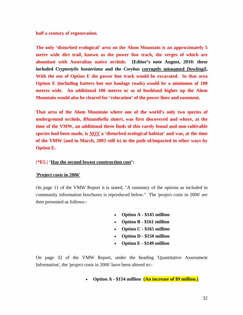
half a century of regeneration. The only ‘disturbed ecological’ area on the Alum Mountain is an approximately 5 metre wide dirt trail, known as the power line track, the verges of which are abundant with Australian native orchids. [Editor’s note August, 2010: these included Cryptostylis hunteriana and the Corybas corruptly misnamed Dowlingi], With the use of Option E the power line track would be excavated. In that area Option E (including batters but not haulage roads) would be a minimum of 100 metres wide. An additional 100 metres or so of bushland higher up the Alum Mountain would also be cleared for ‘relocation’ of the power lines and easement. That area of the Alum Mountain where one of the world’s only two species of underground orchids, Rhizanthella slateri, was first discovered and where, at the time of the VMW, an additional three finds of this rarely found and non-cultivable species had been made, is NOT a ‘disturbed ecological habitat’ and was, at the time of the VMW (and in March, 2003 still is) in the path of/impacted in other ways by Option E. [*E5.] ‘Has the second lowest construction cost’:
'Project costs in 2006'
On page 11 of the VMW Report it is stated, "A summary of the options as included in community information brochures is reproduced below." The 'project costs in 2006' are then presented as follows:-
• Option A - $145 million • Option B - $161 million • Option C - $165 million • Option D - $150 million • Option E - $149 million
On page 32 of the VMW Report, under the heading 'Quantitative Assessment Information', the 'project costs in 2006' have been altered to:-
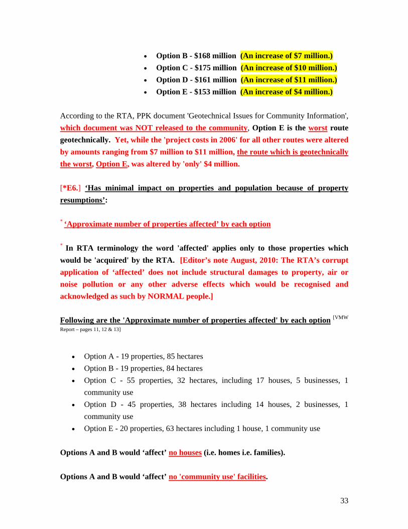
• Option A - $154 million (An increase of $9 million.)
33
• Option B - $168 million (An increase of $7 million.) • Option C - $175 million (An increase of $10 million.) • Option D - $161 million (An increase of $11 million.) • Option E - $153 million (An increase of $4 million.)
According to the RTA, PPK document 'Geotechnical Issues for Community Information', which document was NOT released to the community, Option E is the worst route geotechnically. Yet, while the 'project costs in 2006' for all other routes were altered by amounts ranging from $7 million to $11 million, the route which is geotechnically the worst, Option E, was altered by 'only' $4 million. [*E6.] ‘Has minimal impact on properties and population because of property resumptions’: * ‘Approximate number of properties affected’ by each option * In RTA terminology the word 'affected' applies only to those properties which would be 'acquired' by the RTA. [Editor’s note August, 2010: The RTA’s corrupt application of ‘affected’ does not include structural damages to property, air or noise pollution or any other adverse effects which would be recognised and acknowledged as such by NORMAL people.] Following are the 'Approximate number of properties affected' by each option [VMW
Report – pages 11, 12 & 13]
• Option A - 19 properties, 85 hectares • Option B - 19 properties, 84 hectares • Option C - 55 properties, 32 hectares, including 17 houses, 5 businesses, 1
community use • Option D - 45 properties, 38 hectares including 14 houses, 2 businesses, 1
community use • Option E - 20 properties, 63 hectares including 1 house, 1 community use
Options A and B would ‘affect’ no houses (i.e. homes i.e. families). Options A and B would ‘affect’ no 'community use' facilities.
34
Option E would ‘affect’ one house and one 'community use'. And the 'community use' facility which would be ‘affected’ by Option E is the Alum Mountain Park – a major feature of a unique eco-tourism, recreational and educational area which attracts thousands of visitors per annum. (At the time of the VMW the Alum Mountain Park was to be totally eradicated by Option E and in March, 2003 – after some four or five 'realignments' of this route – the Alum Mountain Park would still lose its sporting recreation area, its footbridge, its historical mullock heaps and its nearby walking trails.) [Editor’s note August, 2010: In a (16th June, 2010) letter from the Australian Government, Alex Foulds, General Manager South East Roads (NSW, ACT, Vic, Tas) Nation Building, Infrastructure Investment, states (re. ‘rockslides’): ‘During construction, any features of the mountain deemed to be unstable will be anchored or removed …’. The above 180 metres above sea level area of the mountain – listed Commonwealth heritage and an acknowledged Aboriginal cultural heritage area would also be damaged by Option E.] [*E7.] ‘Has low noise impacts on sensitive receivers’: This ‘response’ is in direct conflict with ‘responses’ made under ‘What’s not so good is that it’. Those ‘responses’ being:
• Will expose the batter from Bulahdelah township with resulting visual and noise impacts
• [*1] Will result in a possible increase in noise levels to a small number of houses And:
• [*2] Is a difficult option geotechnically *1: ‘Will result in a possible increase in noise levels to a small number of houses’: The number of houses (i.e. people, i.e. ‘sensitive receivers’) in close proximity to Option E is not small. A large percentage of Bulahdelah residences are located on the foot of the Alum Mountain as is a public school with approximately six hundred ‘sensitive receivers’ (i.e. children). Additionally: At the RTA, PPK conducted Community Focus Group Meeting 2 of 10th May, 2000 – over a month prior to the VMW – it was stated that with options to the east of the town ‘noise may reverberate from the [Alum] Mountain, impacting on the town’. Note: ‘impacting on the town’ – not ‘increase in noise levels to a small number of houses’. *2: ‘Is a difficult option geotechnically’: In the RTA document ‘Geotechnical Issues
35
Summary and Route Comparison Table’ it is stated that there is possibly non rippable rock on the Option E route. The noise levels caused during removal of this rock would be extreme. [*E8.] ‘Will have low road user delays during construction’:
Road User Delay Costs during Construction are listed on page 19 of the VMW Report as being: Option A - $348000 Option B - $583000 Option C - $6300000 Option D - $5100000 Option E - $650000 i.e. Option A – Three hundred and forty eight thousand dollars.
Option B – Five hundred and eighty three thousand dollars. Option C – Six million, three hundred thousand dollars. Option D – Five million, one hundred thousand dollars. Option E – Six hundred and fifty thousand dollars.
Road user delay costs for Option E would be three hundred and two thousand dollars more than for Option A and sixty seven thousand dollars more than for Option B. [*E9.] ‘Allows potential development to the North and East’: No ‘development’ is possible in the NSW State Forests managed area to the East of Option E. [*E10.] ‘Allows access to Alum Mountain park from the highway [a blatant LIE – see below – Editor] and an opportunity to upgrade facilities’: [Editor’s note August, 2010: The only access from the highway into Bulahdelah would be the southern and ‘northern’ interchanges – THERE WOULD NOT BE – AND NEVER WAS TO BE – ACCESS FROM THE HIGHWAY TO THE PARK.] It is stated under ‘What’s not so good is that it’ that Option E would:
36
• ‘Require the Alum Mountain picnic area to be relocated’ and would:
• ‘Impact on the picnic area’. At the time of the VMW, the Alum Mountain Park was to have been totally eradicated by Option E. (And – in March, 2003 – much of the Alum Mountain Park would still be eradicated by Option E.) [*E11.] ‘Will provide passengers with a scenic drive along the base of the mountain’: As the Option E roadway would be located in an excavation (cutting) up to 25 metres in depth the only ‘scenery’ with which it would provide passengers would be highway batters. [*E12.] ‘Minimises visual impact of the town’: This ‘response’ should have been listed under ‘What’s not so good is that it’, not ‘What’s good is that it’. (As Option E would be located in an excavation (cutting) up to 25 metres in depth, the town would not be seen from Option E. This route would indeed ‘minimise visual impact of the town’.) [*E13.] ‘Allows better movement for emergency services’:
Option E, by restricting access to the township from the Alum Mountain’s upper regions, would cause time delays for bush walkers and others needing to physically access emergency services.
[*E14.] ‘Require [sic] the Alum Mountain picnic area [the Alum Mountain Park] to be relocated’: The Alum Mountain Park could not be ‘relocated’. At the time of the VMW the Alum Mountain Park was to be eradicated and a new park built in its stead. The new park was to have been located to the east of Option
37
E in an area higher up the slopes of the Alum Mountain. [*E15.] ‘Will impact on the picnic area’ [the Alum Mountain Park]: At the time of the VMW the Alum Mountain Park was to be totally eradicated. And (in March, 2003 – after some four or five ‘realignments’ of Option E) much of the park would still be eradicated by this route. [*E16.] ‘Will expose the batter from Bulahdelah township with resulting visual and noise impacts’: And these noise impacts would be exacerbated by reverberations from the Alum Mountain. ‘Will expose the batter from Bulahdelah township with resulting visual and noise impacts’ corresponds with the statement made at the RTA, PPK conducted Community Focus Group Meeting 2 of 10th May, 2000 where it was stated that with options to the east of the town ‘noise may reverberate from the [Alum] Mountain, impacting on the town’. (Note: ‘impacting on the town’ = resulting noise impacts on Bulahdelah township.) [*E17.] ‘Has a [sic] potential acid sulphate soils’: The Alum Mountain has acid sulphate soils, acid sulphate clays and sulphuric acid producing rock. [Editor’s note: Also high risk acid sulphate soils in the river and floodplain areas – http://bulahdelahbypass.wordpress.com/s-submissions-report/] [*E18.] ‘Will result in a possible increase in noise levels to a small number of houses’: This ‘response’ is in direct conflict with other ‘responses’ made under ‘What’s not so good is that it’. Those ‘responses’ being:
• Will expose the batter from Bulahdelah township with resulting visual and noise impacts
And: • [*] Is a difficult option geotechnically
38
The number of houses (i.e. homes) in close proximity to Option E is not small. A large percentage of Bulahdelah residences (i.e. residents, i.e. ‘sensitive receivers’) are located on the foot of the Alum Mountain as is a public school with approximately six hundred extremely sensitive ‘receivers’ (i.e. children). Additionally: At the RTA, PPK conducted Community Focus Group Meeting 2 of 10th May, 2000 – over a month prior to the VMW – it was stated that with options to the east of the town ‘noise may reverberate from the [Alum] Mountain, impacting on the town’. Note: ‘impacting on the town’ – not ‘a small number of residences’. * ‘Is a difficult option geotechnically’: In the RTA document ‘Geotechnical Issues Summary and Route Comparison Table’ it is stated that there is possibly non rippable rock on the Option E route. The noise levels caused during removal of this rock would be extreme and would be exacerbated by reverberation from the Alum Mountain. [*E19.] ‘Has a potential impact on species’: In the ‘What’s not so good is that it’ section for Option A and the ‘What’s not so good is that it’ section B it is stated respectively:
• [Option A] ‘Creates a new barrier to wildlife corridors’ And:
• [Option B] ‘Presents new barriers to wild life corridors’. The approximately 5 metre wide dirt track – the power line track – which is currently crossed by a many animal species on their way to and from the residential area on the foot of the Alum Mountain does not act as a barrier to fauna. Option E would create an approximately 100 metre wide and up to 25 metres deep barrier along the mountain’s mid-slopes. Also removal of forest (including old growth trees) for an approximately 100 metres wide new section of power line easement. During construction Option E would be highly likely to leave some fauna trapped within the residential area. Option E also ‘Creates a new barrier to wildlife corridors’. The area of the Alum Mountain in the path of Option E has long been renowned for
39
its vast variety of Australian native orchids. Most of these plants are saprophytic – dependent upon specific vegetation for their survival – and many are to be found growing in locations which are unusual for their species. The vegetation upon which one of the world’s only two underground orchids, Rhizanthella slateri, is dependent is, as is its pollinator, unknown. Rhizanthella slateri can not be cultivated and therefore can not be successfully relocated.
The species Rhizanthella slateri was first discovered on the Alum Mountain – in the area in the path of Option E. At the time of the VMW more finds of this species had been made on the Alum Mountain – all in areas now in the path of/affected in other ways by Option E – than at any other location in New South Wales. Since the VMW two further authenticated and documented findings of Rhizanthella slateri have been made (May and June, 2002) in the area which would be affected by Option E. Rhizanthella slateri was given a Final Determination listing as a ‘VULNERABLE SPECIES’ in Schedule 2 of the Threatened Species Conservation Act by the NSW Scientific Committee in December, 2002. The Exhibition period was from 06/12/02 – 24/1/03. Paragraphs 3 and 4 of the Final Determination state:
3. ‘Habitat disturbance has threatened the survival of the species at some of the known sites. One known site is subject to potential clearing for road construction. The small population size at known locations may make the species threatened by stochastic events.’
4. ‘In view of the above the Scientific Committee is of the opinion that
Rhizanthella slateri (Rupp) M.A. Clem. And P.J. Cribb is likely to become endangered unless the circumstances and factors threatening its survival or evolutionary development cease to operate.’
Additionally, Option E would impact large areas with not merely ‘predicted moderate to high archaeological sensitivity’ but with known high archaeological sensitivity. Furthermore, at the time of the VMW the RTA had record of the fact that the Alum Mountain is also highly likely to be of indigenous significance. Yet no mention whatsoever was made of this in the ‘Initial Option Assessment’ of the Option E route.
____________________________________
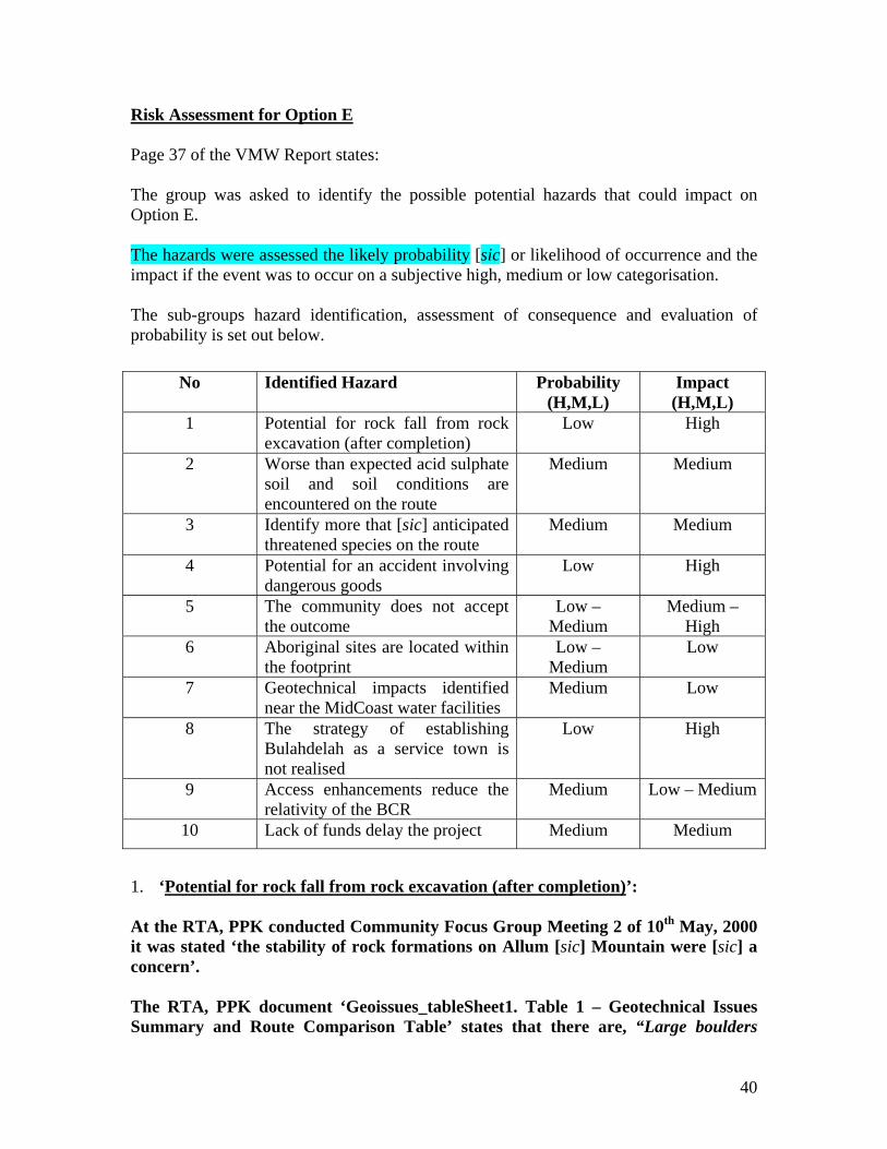
40
Risk Assessment for Option E Page 37 of the VMW Report states: The group was asked to identify the possible potential hazards that could impact on Option E. The hazards were assessed the likely probability [sic] or likelihood of occurrence and the impact if the event was to occur on a subjective high, medium or low categorisation. The sub-groups hazard identification, assessment of consequence and evaluation of probability is set out below.
No Identified Hazard Probability (H,M,L)
Impact (H,M,L)
1 Potential for rock fall from rock excavation (after completion)
Low High
2 Worse than expected acid sulphate soil and soil conditions are encountered on the route
Medium Medium
3 Identify more that [sic] anticipated threatened species on the route
Medium Medium
4 Potential for an accident involving dangerous goods
Low High
5 The community does not accept the outcome
Low – Medium
Medium – High
6 Aboriginal sites are located within the footprint
Low – Medium
Low
7 Geotechnical impacts identified near the MidCoast water facilities
Medium Low
8 The strategy of establishing Bulahdelah as a service town is not realised
Low High
9 Access enhancements reduce the relativity of the BCR
Medium Low – Medium
10 Lack of funds delay the project Medium Medium
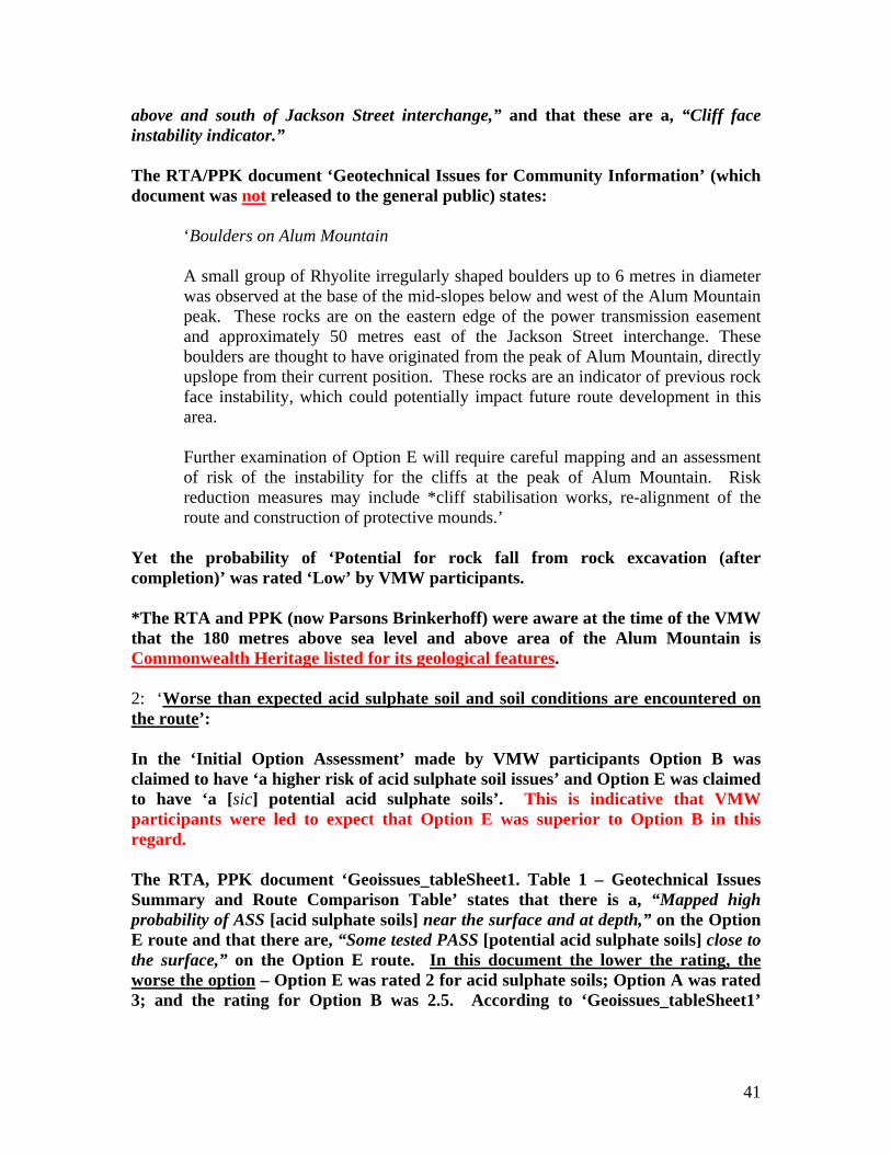
1. ‘Potential for rock fall from rock excavation (after completion)’: At the RTA, PPK conducted Community Focus Group Meeting 2 of 10th May, 2000 it was stated ‘the stability of rock formations on Allum [sic] Mountain were [sic] a concern’. The RTA, PPK document ‘Geoissues_tableSheet1. Table 1 – Geotechnical Issues Summary and Route Comparison Table’ states that there are, “Large boulders
41
above and south of Jackson Street interchange,” and that these are a, “Cliff face instability indicator.” The RTA/PPK document ‘Geotechnical Issues for Community Information’ (which document was not released to the general public) states:
‘Boulders on Alum Mountain A small group of Rhyolite irregularly shaped boulders up to 6 metres in diameter was observed at the base of the mid-slopes below and west of the Alum Mountain peak. These rocks are on the eastern edge of the power transmission easement and approximately 50 metres east of the Jackson Street interchange. These boulders are thought to have originated from the peak of Alum Mountain, directly upslope from their current position. These rocks are an indicator of previous rock face instability, which could potentially impact future route development in this area. Further examination of Option E will require careful mapping and an assessment of risk of the instability for the cliffs at the peak of Alum Mountain. Risk reduction measures may include *cliff stabilisation works, re-alignment of the route and construction of protective mounds.’
Yet the probability of ‘Potential for rock fall from rock excavation (after completion)’ was rated ‘Low’ by VMW participants. *The RTA and PPK (now Parsons Brinkerhoff) were aware at the time of the VMW that the 180 metres above sea level and above area of the Alum Mountain is Commonwealth Heritage listed for its geological features. 2: ‘Worse than expected acid sulphate soil and soil conditions are encountered on the route’: In the ‘Initial Option Assessment’ made by VMW participants Option B was claimed to have ‘a higher risk of acid sulphate soil issues’ and Option E was claimed to have ‘a [sic] potential acid sulphate soils’. This is indicative that VMW participants were led to expect that Option E was superior to Option B in this regard. The RTA, PPK document ‘Geoissues_tableSheet1. Table 1 – Geotechnical Issues Summary and Route Comparison Table’ states that there is a, “Mapped high probability of ASS [acid sulphate soils] near the surface and at depth,” on the Option E route and that there are, “Some tested PASS [potential acid sulphate soils] close to the surface,” on the Option E route. In this document the lower the rating, the worse the option – Option E was rated 2 for acid sulphate soils; Option A was rated 3; and the rating for Option B was 2.5. According to ‘Geoissues_tableSheet1’
42
Option E is likely to have the highest acid sulphate soil content of these three options. Option E is the only route which has both acid sulphate soils and ‘Acid generating rock’ which ‘impacts on surface water quality’. [Pacific Highway Upgrade – Bulahdelah Review of
Environmental Factors (REF) – page 16.]
Yet the probability of ‘Worse than expected acid sulphate soil and soil conditions’ was rated ‘Medium’ by VMW participants. Added by Editor August, 2010:- 3: ‘Identify more that [sic] anticipated threatened species on the route’ – allocated a probability rating of ‘medium’: Presumably stemming from the FRAUDULENT description ‘passes through sensitive but disturbed ecological habitats’ (‘What’s good is that it [Option E]’). Added by Editor August, 2010:- 4: ‘Potential for an accident involving dangerous goods’ – allocated a probability rating of ‘low’:
STUDIES … SHOW [that] CRASH RATES INCREASE SIGNIFICANTLY when truck speed reduction exceeds 15 kilometres per hour. Ref: Bulahdelah Upgrading the Pacific
Between Bombah Point Road and the mountain access track near Mountain Park: The new highway would climb at approximately 3 percent over 900 metres, creating SPEED REDUCTIONS OF APPROXIMATELY 25 KILOMETRES PER HOUR FOR LADEN TRUCKS in the northbound direction. Ref: EIS Main Volume 8.2.5. Design,
Engineering and Constructability
THERE ARE RISKS TO DRIVERS on the proposed Upgrade, AND TO RESIDENTS of Bulahdelah associated with boulders falling from the cliffs and slopes upslope from the proposed Upgrade’. Ref: EIS Main Volume 8.2.5
‘THERE ARE ALSO RISKS OF SLOPE FAILURE of the colluvial material [i.e. soils, rocks and gravel etc. of the already occurred landslide] DURING both CONSTRUCTION AND the OPERATION of the proposal’. Ref: EIS Main Volume 8.2.5
Added by Editor August, 2010:- 5: ‘The community does not accept the outcome’ – allocated a probability rating of ‘low – medium’: THIS IS EVIDENCE OF CONSULTATION FAILURE.
43
6: Aboriginal sites are located within the footprint – allocated a probability rating of ‘low – medium’: Extracts from the ‘PACIFIC HIGHWAY (STATE HIGHWAY NO.10) Bulahdelah – Coolongolook Deviation Environmental Impact Statement WORKING PAPERS’ of September, 1990: Page 52 – re. ‘Aboriginal Occupation of the Bulahdelah Forests’:- “Site 9 … The site is extensive, following along the ridge top for at least 200m [the full extent of the site was not determined]. The artefacts are made on [sic] a variety of stone materials, including volcanics which may have come from Bulahdelah Mountain. … .” Page 53 – ‘Types of Sites’: “Shelter Sites – … It should be noted that large boulders do occur along the side of Bulahdelah Mountain, and the possibility of habitable shelters occurring there should not be discounted.” The mountain referred to as ‘Bulahdelah Mountain’ in the above document is known as the Alum Mountain, Bulahdelah. At the time of the VMW the RTA had record of the fact that the Alum Mountain, Bulahdelah – in the path of Option E – was highly likely to be of indigenous significance. [Editor’s note: Aboriginal sites – WITHIN AND ADJACENT TO THE OPTION E FOOTPRINT – were also documented by Navin Officer – FOR THE RTA – in the Proposed Pacific Highway Bulahdelah Upgrade Route Selection Study – Indigenous Cultural Heritage Component. Said heritage component was published in May, 2000 – three months prior to the Value Management Workshop.] Yet the probability of Aboriginal sites being located within the footprint of Option E was rated ‘Low to Medium’ by VMW participants.