2 A Server-Assigned Spatial Crowdsourcing Framework HIEN TO and CYRUS SHAHABI, University of Southern California LEYLA KAZEMI, Microsoft Corporation With the popularity of mobile devices, spatial crowdsourcing is rising as a new framework that enables human workers to solve tasks in the physical world. With spatial crowdsourcing, the goal is to crowdsource a set of spatiotemporal tasks (i.e., tasks related to time and location) to a set of workers, which requires the workers to physically travel to those locations in order to perform the tasks. In this article, we focus on one class of spatial crowdsourcing, in which the workers send their locations to the server and thereafter the server assigns to every worker tasks in proximity to the worker’s location with the aim of maximizing the overall number of assigned tasks. We formally define this maximum task assignment (MTA) problem in spatial crowdsourcing, and identify its challenges. We propose alternative solutions to address these challenges by exploiting the spatial properties of the problem space, including the spatial distribution and the travel cost of the workers. MTA is based on the assumptions that all tasks are of the same type and all workers are equally qualified in performing the tasks. Meanwhile, different types of tasks may require workers with various skill sets or expertise. Subsequently, we extend MTA by taking the expertise of the workers into consideration. We refer to this problem as the maximum score assignment (MSA) problem and show its practicality and generality. Extensive experiments with various synthetic and two real-world datasets show the applicability of our proposed framework. Categories and Subject Descriptors: H.2.8 [Database Management]: Database Applications Spatial databases and GIS General Terms: Algorithms Additional Key Words and Phrases: Crowdsourcing, spatial crowdsourcing, mobile crowdsourcing, spatial task assignment, participatory sensing ACM Reference Format: Hien To, Cyrus Shahabi, and Leyla Kazemi. 2015. A server-assigned spatial crowdsourcing framework. ACM Trans. Spatial Algorithms Syst. 1, 1, Article 2 (July 2015), 28 pages. DOI: http://dx.doi.org/10.1145/2729713 1. INTRODUCTION With the ubiquity of smartphones and wireless network bandwidth improvements, every person with a mobile phone can now act as a multimodal sensor, collecting and sharing various types of high-fidelity spatiotemporal data instantaneously (e.g., pictures, video, audio, location, time, speed, direction, acceleration). Exploiting this The work was completed when the author was a PhD student at University of Southern California’s Infolab. This research has been funded in part by National Science Foundation (NSF) grants IIS-1320149 and CNS-1461963, the USC Integrated Media Systems Center (IMSC), and unrestricted cash gifts from Google, Northrop Grumman, Microsoft, and Oracle. Any opinions, findings, and conclusions or recommendations expressed in this material are those of the authors and do not necessarily reflect the views of any of the sponsors such as the NSF. Authors’ addresses: H. To, InfoLab, 3710 S. McClintock Ave, RTH 323, Los Angeles, CA 90089; email: [email protected]; C. Shahabi, 3737 Watt Way, PHE 306A, Los Angeles, CA 90089; email: [email protected]; L. Kazemi, 1 Microsoft Way, Redmond, WA 98052; email: [email protected]. Permission to make digital or hard copies of part or all of this work for personal or classroom use is granted without fee provided that copies are not made or distributed for profit or commercial advantage and that copies show this notice on the first page or initial screen of a display along with the full citation. Copyrights for components of this work owned by others than ACM must be honored. Abstracting with credit is permitted. To copy otherwise, to republish, to post on servers, to redistribute to lists, or to use any component of this work in other works requires prior specific permission and/or a fee. Permissions may be requested from Publications Dept., ACM, Inc., 2 Penn Plaza, Suite 701, New York, NY 10121-0701 USA, fax +1 (212) 869-0481, or [email protected]. c 2015 ACM 2374-0353/2015/07-ART2 $15.00 DOI: http://dx.doi.org/10.1145/2729713 ACM Transactions on Spatial Algorithms and Systems, Vol. 1, No. 1, Article 2, Publication date: July 2015.
Transcript
2
A Server-Assigned Spatial Crowdsourcing Framework
HIEN TO and CYRUS SHAHABI, University of Southern CaliforniaLEYLA KAZEMI, Microsoft Corporation
With the popularity of mobile devices, spatial crowdsourcing is rising as a new framework that enableshuman workers to solve tasks in the physical world. With spatial crowdsourcing, the goal is to crowdsourcea set of spatiotemporal tasks (i.e., tasks related to time and location) to a set of workers, which requiresthe workers to physically travel to those locations in order to perform the tasks. In this article, we focus onone class of spatial crowdsourcing, in which the workers send their locations to the server and thereafterthe server assigns to every worker tasks in proximity to the worker’s location with the aim of maximizingthe overall number of assigned tasks. We formally define this maximum task assignment (MTA) problemin spatial crowdsourcing, and identify its challenges. We propose alternative solutions to address thesechallenges by exploiting the spatial properties of the problem space, including the spatial distribution andthe travel cost of the workers. MTA is based on the assumptions that all tasks are of the same type andall workers are equally qualified in performing the tasks. Meanwhile, different types of tasks may requireworkers with various skill sets or expertise. Subsequently, we extend MTA by taking the expertise of theworkers into consideration. We refer to this problem as the maximum score assignment (MSA) problemand show its practicality and generality. Extensive experiments with various synthetic and two real-worlddatasets show the applicability of our proposed framework.
Categories and Subject Descriptors: H.2.8 [Database Management]: Database Applications Spatialdatabases and GIS
General Terms: Algorithms
Additional Key Words and Phrases: Crowdsourcing, spatial crowdsourcing, mobile crowdsourcing, spatialtask assignment, participatory sensing
ACM Reference Format:Hien To, Cyrus Shahabi, and Leyla Kazemi. 2015. A server-assigned spatial crowdsourcing framework. ACMTrans. Spatial Algorithms Syst. 1, 1, Article 2 (July 2015), 28 pages.DOI: http://dx.doi.org/10.1145/2729713
1. INTRODUCTION
With the ubiquity of smartphones and wireless network bandwidth improvements,every person with a mobile phone can now act as a multimodal sensor, collectingand sharing various types of high-fidelity spatiotemporal data instantaneously (e.g.,pictures, video, audio, location, time, speed, direction, acceleration). Exploiting this
phenomenon, a new framework for efficient and scalable data collection has emerged,namely spatial crowdsourcing [Kazemi and Shahabi 2012]. With spatial crowdsourc-ing, the goal is to crowdsource a set of spatial tasks (i.e., tasks related to a location) to aset of workers, which requires the workers to physically go to those locations in order toperform the tasks. Spatial crowdsourcing has application in numerous domains suchas journalism, tourism, intelligence, disaster response, and urban planning. To illus-trate, consider a disaster-response scenario, in which the Red Cross (i.e., requester) isinterested in collecting pictures and videos of disaster areas from various locations of acity. With spatial crowdsourcing, the requester issues a query to a spatial crowdsourc-ing server (SC-server). Consequently, the SC-server crowdsources the query among theavailable workers in the vicinity of the event. Once the workers document the eventwith their mobile phones, the results are sent back to the requester.
While crowdsourcing has largely been used by research communities, for example,image processing (Chen et al. [2009], Sorokin and Forsyth [2008], and Whitehill et al.[2009]) and databases (Franklin et al. [2011], Marcus et al. [2011], Parameswaranet al. [2012], and Demartini et al. [2013]), and by industry, for example, oDesk [2005],MTurk [Amazon 2005] and Crowdflower [2009], spatial crowdsourcing has only re-cently received attention (To et al. [2014], Musthag and Ganesan [2013], Kazemi et al.[2013], Kazemi and Shahabi [2012], and Alt et al. [2010]). Moreover, most existingwork on spatial crowdsourcing focuses on a particular class of spatial crowdsourcing,called participatory sensing. With participatory sensing, the goal is to exploit the mo-bile users for a given campaign by leveraging their sensor-equipped mobile devices tocollect and share data. Some real-world examples of participatory sensing campaignsare described in UCB [2008], Hull et al. [2006], and Mohan et al. [2008]. For example,the Mobile Millennium project [UCB 2008] by UC Berkeley is a state-of-the-art sys-tem that uses GPS-enabled mobile phones to collect en route traffic information andupload it to a server in real time. The server processes the contributed traffic data,estimates future traffic flows, and sends traffic suggestions and predictions back to themobile users. Similar projects were implemented earlier by CarTel [Hull et al. 2006]and Nericell [Mohan et al. 2008], which used mobile sensors/smartphones mountedon vehicles to collect information about traffic, WiFi access points on the route, androad information. All these previous studies on participatory sensing focus on a singlecampaign and try to address challenges specific to that campaign. However, our focusis on devising a generic crowdsourcing framework, similar to MTurk, in which mul-tiple campaigns can be handled simultaneously, but spatially. Most existing studieson participatory sensing focus on small campaigns with a limited number of workers,and are not scalable to large spatial crowdsourcing applications. To move from single-campaign and customized participatory sensing to multi-purpose and generic spatialcrowdsourcing, the system needs to scale, that is, it should be able to efficiently assigntasks to workers.
In this article, we first introduce our problem focus, spatial crowdsourcing, in thecontext of crowdsourcing. Next, we focus on one class of crowdsourcing, known asserver assigned, in which a set of workers send their task inquiries to an SC-server.The task inquiry of a worker, which includes the individual’s location along with aset of constraints (e.g., a region), is a request that the worker issues to inform theSC-server of availability to work. Consequently, the server, which receives the locationof the workers, assigns to all workers their nearby tasks. The optimization goal is tomaximize the number of assigned tasks while conforming to the constraints of theworkers, referred to as maximum task assignment (MTA). The solution to the MTAcould be straightforward if the SC-server had a global knowledge of both the spatialtasks and the workers. However, the server is continuously receiving spatial tasksfrom requesters and task inquiries from the workers. Therefore, the server can only
ACM Transactions on Spatial Algorithms and Systems, Vol. 1, No. 1, Article 2, Publication date: July 2015.
A Server-Assigned Spatial Crowdsourcing Framework 2:3
maximize the task assignment at every time instance (i.e., local optimization) with noknowledge of the future. We proposed three alternative solutions to the MTA problem.The first approach, Basic, follows the local optimization strategy by maximizing thetask assignment at every time instance. Our second approach, called Least LocationEntropy Priority (LLEP), improves the overall task assignment by assigning higherpriority to spatial tasks located in worker-sparse areas (i.e., places with lower locationentropy). The intuition is that spatial tasks are more likely to be performed in futureif they are located in worker-dense areas (i.e., areas with high population of workersor high location entropy). With spatial crowdsourcing, the travel cost of the workersbecomes critical. Thus, in our third approach, Close Distance Priority (CDP), we in-corporate the travel cost of the workers into the task assignment by assigning higherpriority to the tasks with lower travel cost.
So far, we assume that all tasks are of the same type and all workers are equallyqualified to perform the tasks. We relax these assumptions by allowing each workerto have a set of skills and every spatial task to have a type. Subsequently, we defineexpertise match as an assignment of a task to a worker for which the worker has therequired qualification to perform the task (e.g., the task of taking a high-quality pictureis assigned to a photographer). Thus, we assign higher scores to expertise matchesthan to nonexpertise matches (i.e., matches that satisfy only worker’s constraints).Consequently, we formalize a new problem named Maximum Score Assignment (MSA),whose optimization goal is to maximize the total score assignment while conforming tothe constraints of the workers. To solve MSA, we extend the same heuristics to MTA,including Basic, LLEP and CDP. Assuming that there is only one task type and allworkers are the same, MSA becomes MTA, that is, MSA is a generalization of MTA.Therefore, we evaluate only the solutions to MSA in our experiments.
Our extensive experiments on both real and synthetic data show that, in comparisonwith Basic, our LLEP improves the overall task assignment (i.e., total score) by up to35%, while the CDP approach can improve the travel cost of the workers by up to 90%.Furthermore, with our real datasets, LLEP shows its superiority in maximizing thenumber of expertise matches by up to 30% when compared to the other approaches.Moreover, an unexpected positive side effect of minimizing the travel cost in CDP ismaximizing the number of expertise matches. As a result, the CDP approach is betterthan LLEP by up to 15% in maximizing the number of expertise matches with oursynthetic data. Consequently, based on the objective of the crowdsourcing application(i.e., maximizing the assignment or minimizing travel cost), either of the LLEP orCDP approaches can be selected. Finally, by varying the expertise match score, we canflexibly change the optimization goal (e.g., from maximum assigned tasks to maximumexpertise matches), showing the practicality and generality of MSA when compared tothe MTA problem.
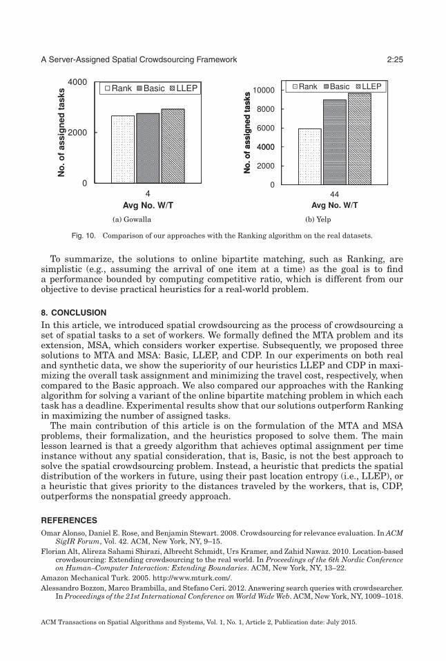
A related problem, online matching [Karp et al. 1990; Kalyanasundaram and Pruhs2000], can be considered as a special case of our task assignment (i.e., MTA and MSA),in which the worker set (or task set) is given in advance while items in the other setarrive one at a time or in a batch. In Section 2, we distinguish MTA and MSA fromthe online bipartite matching problems, which do not use any spatial knowledge. Wealso experimentally compare our approaches, Basic and LLEP, with a typical onlinebipartite matching algorithm called Ranking [Karp et al. 1990]. Experimental resultson both real and synthetic data show that our approaches outperform the Rankingalgorithm in terms of maximizing the number of assigned tasks.
In a preliminary version of this work [Kazemi and Shahabi 2012], we introducedMTA and the three approaches: Basic, LLEP, and CDP. This article subsumes Kazemiand Shahabi [2012] by relaxing the assumptions of identical workers and tasks as wellas solving the MSA problem, which is a generalization of MTA. We also relate our
ACM Transactions on Spatial Algorithms and Systems, Vol. 1, No. 1, Article 2, Publication date: July 2015.
2:4 H. To et al.
problem to the online bipartite matching problem and add a new set of experiments inorder to compare our heuristics with a solution to the online matching problem [Karpet al. 1990], called the Ranking algorithm. For this comparison, we need to modify ourexperimental setup so that the worker set as well as the cost of matches are known inadvance. Moreover, in this article, to evaluate the approaches, we generate syntheticdatasets in a more systematic manner. We also use new real-world data from Yelp,which is suitable for evaluating MSA.
The remainder of this article is organized as follows. In Section 2, we review therelated work. Section 3 presents the taxonomy for crowdsourcing and introduces ourproblem focus, spatial crowdsourcing. In Section 4, we discuss a set of preliminaries inthe context of spatial crowdsourcing.In Sections 5 and 6, we formally define the MTAproblem and its extension, MSA, then explain our assignment solutions. Section 7reports on our experimental results. We present our conclusions in Section 8.
2. RELATED WORK
Crowdsourcing: Crowdsourcing has recently been attracting extensive attention inthe research community. A recent survey in this area can be found in Kittur et al.[2013]. With a growing recognition of crowdsourcing, many crowdsourcing services,including oDesk [2005], MTurk [Amazon 2005] and Crowdflower [2009], have emergedthat allow requesters to issue tasks that workers can perform for a certain reward.Crowdsourcing has been largely adopted in a wide range of applications. Examplesof such applications include, but are not limited to, image search [Yan et al. 2010],natural language annotations [Snow et al. 2008], video and image annotations [Chenet al. 2009; Sorokin and Forsyth 2008; Whitehill et al. 2009], search relevance [Alonsoet al. 2008; Bozzon et al. 2012], social games [Von Ahn and Dabbish 2008; Guy et al.2011] and graph search [Parameswaran et al. 2011]. Moreover, the database communityhas utilized crowdsourcing in database design, query processing [Franklin et al. 2011;Marcus et al. 2011; Parameswaran et al. 2012; Demartini et al. 2013; Zhao et al. 2013]and data analytics [Liu et al. 2012; Wang et al. 2012]. Franklin et al. [2011] proposea relational query processing system that uses crowdsourcing to answer queries thatcannot otherwise be answered. As part of the crowdsourced database systems, human-powered versions of the fundamental operators, such as sort and join [Marcus et al.2011] and filter [Parameswaran et al. 2012], were developed. Liu et al. [2012] developeda system to improve the accuracy of data analytics jobs by exploiting crowdsourcingtechniques.
Spatial Crowdsourcing: Despite all the studies on crowdsourcing, spatial crowdsourc-ing has only recently received attention [To et al. 2014; Deng et al. 2013; Kazemi et al.2013; Dang et al. 2013; Kazemi and Shahabi 2012; Alt et al. 2010]. Alt et al. [2010]propose a crowdsourcing platform that utilizes location as a parameter to distributetasks among workers. Kazemi and Shahabi [2012] propose a spatial crowdsourcingplatform whose goal is to maximize the number of assigned tasks. Since the workerscannot always be trusted, another work aims to tackle the issue of trust by having tasksperformed redundantly by multiple workers [Kazemi et al. 2013]. Dang et al. [2013]introduce the problem of complex spatial tasks (i.e., each task comprises a set of spatialsubtasks), in which the assignment of the complex task requires performing all of itssubtasks. Meanwhile, the problem of scheduling tasks for a worker that maximizesthe number of performed tasks is proposed in Deng et al. [2013]. In ul Hassan andCurry [2014], an online spatial task assignment problem is suggested to maximize thenumber of successful assignments. Recently, To et al. [2014] introduced the problemof protecting worker location privacy in spatial crowdsourcing. This study proposesa framework that achieves differentially-private protection guarantees. The solutionsfor this problem are quite complex, and require tuning multiple parameters to obtain
ACM Transactions on Spatial Algorithms and Systems, Vol. 1, No. 1, Article 2, Publication date: July 2015.
A Server-Assigned Spatial Crowdsourcing Framework 2:5
satisfactory results. Thus, the same authors propose PrivGeoCrowd [To et al. 2015], aninteractive visualization and tuning toolbox for privacy-preserving spatial crowdsourc-ing. PrivGeoCrowd helps system designers investigate the effect of parameters such asprivacy budget and allocation strategy, task-assignment heuristics, and dataset den-sity on the effectiveness of private task matching. At the same time, privacy-preservingtask assignment using cloaked locations is proposed in Pournajaf et al. [2014].
The problem of crowdsourcing location-based queries over Twitter has also beenstudied, which employs a location-based service (e.g., Foursquare) to find the appropri-ate people to answer a given query [Bulut et al. 2011]. Even though this work focuseson location-based queries, it does not assign to users any spatial task for which the usershould go to that location and perform the corresponding task. Instead, it chooses usersbased on their historical Foursquare check-ins. In Musthag and Ganesan [2013], spa-tiotemporal dynamics in mobile task markets, such as Field Agent [2010] and Gigwalk[2010], were studied.
The well-known concept of participatory sensing could be deemed as one class ofspatial crowdsourcing, in which workers form a campaign to perform sensing tasks.Examples of works describing participatory sensing campaigns include UCB [2008],Kazemi and Shahabi [2011], Cornelius et al. [2008], Hull et al. [2006], and Mohan et al.[2008]. However, the major drawback of all the existing works on participatory sensingis that they focus on a single campaign and try to address the challenges specific tothat campaign. Another drawback of most existing studies on participatory sensing(e.g., Kazemi and Shahabi [2011]) is that they are designed for small campaigns, witha small number of participants, and are not scalable to large spatial crowdsourcingapplications. Finally, while most existing works on participatory sensing systems focuson a particular application, our work can be used for any type of spatial crowdsourcingsystem.
Another class of spatial crowdsourcing is known as volunteered geographic infor-mation (VGI), whose goal is to create geographic information provided voluntarily byindividuals. Examples for this class include Google Map Maker [GoogleMapMaker2008], OpenStreetMap [2004] and Wikimapia [2006]. These projects allow the users togenerate their own geographic content and add it to a prebuilt map. For example, a usercan add the features of a location or the events occurring at that location. However,the major difference between VGI and spatial crowdsourcing is that, in VGI, usersvoluntarily participate by randomly contributing data, whereas in spatial crowdsourc-ing, a set of spatial tasks are queried by the requesters and workers are required toperform those tasks. Moreover, with most VGI projects (GoogleMapMaker [2008] andWikimapia [2006]), users are not required to physically go to a particular location inorder to generate data with respect to that location. Finally, as the name suggests, VGIfalls into the class of self-incentivized crowdsourcing.
Matching Problems: One can consider the task assignment problem in spatial crowd-sourcing as the online bipartite matching problem (Karp et al. [1990], Kalyanadun-daram and Pruhs [1993], Khuller et al. [1994], Kalyanasundaram and Pruhs [2000],and Mehta et al. [2007]). The online bipartite matching problem is the most relevantvariation of spatial crowdsourcing, as it captures the dynamism of tasks arriving atdifferent times. However, in online bipartite matching one of the itemsets is given inadvance and items from the other set arrive (usually one at a time), while in spatialcrowdsourcing both sets, that is, workers and tasks, can come and go without ourknowledge. Thus, to some extent, online matching can be considered as a special caseof our task assignment, in which the worker set (or task set) is fixed. In addition, withonline matching, the cost/weight of any match is known in advance. However, withspatial crowdsourcing, the cost for a worker to perform a task mainly corresponds tothe time it takes for that worker to travel to the location of the task. As the result, the
ACM Transactions on Spatial Algorithms and Systems, Vol. 1, No. 1, Article 2, Publication date: July 2015.
2:6 H. To et al.
cost of a task is not a fixed value but is dependent on the worker’s prior location. Hence,the sequence in which the tasks are performed impacts the cost: that is, with spatialcrowdsourcing, the cost of the execution of a set of tasks is the distance of the shortestpath that starts from the worker’s current location and goes through the locations of allthe assigned tasks. On the other hand, with online matching [Kalyanasundaram andPruhs 2000] the overall cost for one worker would be the sum of the distances betweenthe worker and each assigned task. Finally, the performance of an online algorithm isoften evaluated based on competitive ratio: the ratio between its performance and theoffline algorithm’s performance. The online algorithm is competitive if its competitiveratio is bounded under any circumstance; this is not the goal of MSA, which focuses onthe average performance.
Some recent studies in spatial matching, Wong et al. [2007] and Yiu et al. [2008],do focus on efficiency and use the spatial features of the objects for more efficientassignment. Spatial matching is a one-to-one (or in some cases one-to-many) assign-ment between objects of two sets, in which the goal is to optimize over some aggregatefunction (e.g., sum, max) of the distance between matched objects. For example, theobjective in Varadarajan [1998] is to pair up 2N points in the plane into N pairs suchthat the sum of the Euclidean distances between the paired points is minimized. InWong et al. [2007], given a set of customers and a set of service providers with limitedcapacities, the goal is to assign the maximum number of customers to their nearestproviders, among all the providers whose capacities have not been exhausted in serv-ing other closer customers. These studies assume that a global knowledge about thelocations of all objects exists a priori, and the challenge comes from the complexityof spatial matching. However, spatial crowdsourcing differs due to the dynamism oftasks and workers (i.e., tasks and workers come and go without our knowledge), thusthe challenge is to perform the task assignment at a given instance of time with thegoal of global optimization across all times. Moreover, the fact that workers need totravel to task locations causes the landscape of the problem to change constantly. Thisadds another layer of dynamism to spatial crowdsourcing that renders it a uniqueproblem.
Expertise matching is the concept of assigning queries to experts that has gainedextensive interest from various research fields for its wide range of applications suchas paper–reviewer assignment (Mimno and McCallum [2007] and Hettich and Pazzani[2006]) and project-reviewer matching (Sun et al. [2008]). In Tang et al. [2012], aframework for expertise matching with various constraints was introduced that iscapable of rendering the optimal solution. However, none of these studies address theproblem of expertise in spatial matching. Our objective is different from these studiesas we address the problem of maximum expertise matches, while they try to find thebest individual match based on some models/methods.
Vehicle Routing Problems: Modeling the assignment cost as the shortest path visit-ing the location of multiple tasks creates another class of problems. In this context,the assignment problem in spatial crowdsourcing becomes similar to the TravelingSalesman Problem (TSP) [Lawler et al. 1985] and the Vehicle Routing Problem (VRP)[Toth and Vigo 2001]. The goal of the VRP is to minimize the cost of delivering goodslocated at a central depot to customers who have placed orders for such goods witha fleet of vehicles. The online versions of both the TSP and VRP have been studiedto some extent where new locations to visit are revealed incrementally. Since there isonly one salesman in the standard version of the TSP, here we focus on the VRP. Dif-ferent variations of the VRP have been studied, yet there are differences between taskassignment in spatial crowdsourcing and these variations. With the VRP, all workersstart from the same depot, whereas in spatial crowdsourcing each worker can have adifferent starting location. Moreover, with the VRP we have a fixed number of workers,
ACM Transactions on Spatial Algorithms and Systems, Vol. 1, No. 1, Article 2, Publication date: July 2015.
A Server-Assigned Spatial Crowdsourcing Framework 2:7
Fig. 1. The focus of this article, spatial crowdsourcing, is shown in grey.
whereas in spatial crowdsourcing the same type of dynamism for tasks can apply tothe workers, that is, workers can be added/removed to/from the system at any time.
3. SPATIAL CROWDSOURCING
Spatial crowdsourcing opens up a new mechanism for spatial tasks (i.e., tasks relatedto a location) to be performed by humans. Consequently, we formally define spatialcrowdsourcing as the process of crowdsourcing a set of spatial tasks to a set of hu-man workers when performing an outsourced task is only possible if the workers arephysically at the location of the task, termed spatial task. In this section, we present ataxonomy for crowdsourcing (Figure 1). First, we classify spatial crowdsourcing basedon worker’s motivation. Next, we define two modes of task publishing in spatial crowd-sourcing. Finally, we classify the workers into two groups based on whether or not theyhave constraints.
3.1. Worker’s Motivation
A major challenge in any crowdsourcing system is how to motivate people to participate.Four levels of worker motivation can be found in Quinn and Bederson [2011], includingpay, altruism, fun, and implicit. To simplify, crowdsourcing can be classified basedon the motivation of the workers into two classes: reward-based and self-incentivized(Figure 1). With reward-based spatial crowdsourcing, every spatial task has a price(assigned by a requester) and workers will receive a certain reward for every spatialtask they perform correctly. Examples of this class include Field Agent [2010] andGigwalk [2010]. With self-incentivized spatial crowdsourcing, workers volunteer toperform the tasks or usually have other incentives rather than receiving a reward,such as documenting an event or promoting their cultural, political or religious views.An example of this class is described in UCB [2008], in which more than 5000 usersvoluntarily install traffic software onto their phones and report traffic information. Ourwork focuses on self-incentivized spatial crowdsourcing.
3.2. Task Publishing Modes
Next, we define two task publishing modes in spatial crowdsourcing, Worker SelectedTasks (WST) and Server Assigned Tasks (SAT). With the WST mode, the SC-serverpublishes the spatial tasks and online workers can choose any spatial task in theirvicinity without the need to coordinate with the server. One advantage of the WST modeis that the workers do not need to reveal their locations to the SC-server since they canchoose any arbitrary task in their vicinity autonomously. However, one drawback of this
ACM Transactions on Spatial Algorithms and Systems, Vol. 1, No. 1, Article 2, Publication date: July 2015.
2:8 H. To et al.
mode is that the server does not have any control over the allocation of spatial tasks.This may result in some spatial tasks never being assigned, while others are assignedredundantly. Another drawback of the WST is that workers choose tasks based on theirown objectives (e.g., choosing the k closest spatial tasks to minimize their travel cost),which may not result in a globally optimal assignment. An example of the WST modeis described in Alt et al. [2010], in which the workers browse for available spatial tasksand pick the ones in their neighborhood.
With the SAT mode, the SC-server does not publish the spatial tasks to the workers.Instead, any online worker sends one’s location to the SC-server. The SC-server, afterreceiving the locations of all online workers, assigns to every worker a close-by tasks.The advantage of the SAT is that, unlike the WST, the SC-server has the big picture,thus can assign to every worker nearby tasks while maximizing the overall task assign-ment. Examples of this mode of spatial crowdsourcing are described by Kazemi andShahabi [2012, 2011]. In Kazemi and Shahabi [2011], a framework for small campaignsis proposed, in which workers are assigned to their close-by sensing tasks. However,the drawback is that the workers should report their locations to the server for everyassignment, which can pose a privacy threat. Recently, To et al. [2014] proposed aframework to sanitize workers’ locations according to differential privacy while stillusing an SC-server as a broker to assign tasks to workers. A real-world example of theSAT mode is Uber1, a mobile app that connects passengers with drivers of vehicles forridesharing. Our focus in this article is on this mode of spatial crowdsourcing.
3.3. Worker’s Constraints
Finally, in the case of the SAT, we divide the workers into two groups based on whetheror not they have constraints. With workers without constraints, the server has fullflexibility on how tasks should be assigned to the workers. This means that workerssend their locations only to the server, and the server assigns every spatial task toits nearby worker [Kazemi and Shahabi 2011]. With workers with constraints, theserver needs to satisfy the constraints while assigning the tasks. An example of spatialconstraint is that every worker only accepts spatial tasks in a spatial region (i.e., one’sworking region).
4. PRELIMINARIES
In this section, we define a set of preliminaries in the context of self-incentivized SATspatial crowdsourcing with constraints. First, we formally define a spatial task.
Definition 4.1 (Spatial Task). A spatial task t of form <l, q, s, δ> is a query q to beanswered at location l, where l is a point in 2D space. The query is asked at time s andwill be expired at time s + δ.
Note that the query q of a spatial task t can be answered by a human only if thehuman is physically located at location l by traveling to the location. An example of aspatial task is taking a picture of a particular dish in a restaurant. This means that theworker needs to physically go to the exact location of the restaurant in order to takethe picture. Each task has a deadline, and it can appear at several time instances untilreaching its deadline. A task expires if it has not been answered before its deadline2.For example, if one time instance is 2 minutes long and the task deadline is within40 minutes, the task can last for 20 time instances.
1https://www.uber.com/.2We use the tasks’ deadlines to exclude them for assignment in the time instances passed their deadlines.
ACM Transactions on Spatial Algorithms and Systems, Vol. 1, No. 1, Article 2, Publication date: July 2015.
A Server-Assigned Spatial Crowdsourcing Framework 2:9
Fig. 2. The spatial crowdsourcing framework.
Definition 4.2 (Spatial Crowdsourced Query). A spatial crowdsourced query (or SC-query) of form <t1, t2, . . .> asked by a requester is a set of spatial tasks ti that needs tobe crowdsourced.
After receiving the SC-queries from all the requesters, the spatial crowdsourcingserver (or SC-server) assigns the spatial tasks of these SC-queries to the availableworkers. We assume that all workers perform every task correctly. Thus, the SC-serverneeds to assign every spatial task to one and only one worker. Figure 2 shows ourspatial crowdsourcing framework. In the following we formally define a worker.
Definition 4.3 (Worker). A worker, denoted by w, is a carrier of a mobile device whovolunteers to perform spatial tasks. A worker can be in either an online or offline mode.A worker is online when ready to accept tasks.
We assume that all tasks are of the same type and all workers have the same set ofskills. We will relax these assumptions in Section 6. Once a worker goes online, thatindividual sends a task inquiry to the SC-server (Figure 2). We now formally define thetask inquiry.
Definition 4.4 (Task Inquiry or TI). Task inquiry is a request that an online workerw sends to the SC-server, when ready to work. The inquiry includes location of w, l,along with two constraints: a spatial region R and the maximum number of acceptabletasks maxT.
The spatial region R represented by a rectangle is the area in which the worker canaccept spatial tasks. The other constraint, maxT, is the maximum number of tasks thatthe worker is willing to perform in one time instance. The worker can have either orboth of the constraints3. Figure 2 shows an example of task inquiry, in which workerw1 has only one constraint (i.e., R1) and worker w2 has both constraints (i.e., R2 andmaxT2). Note that the task inquiry is defined for the SAT mode with the constraintsscenario (see Taxonomy in Figure 1), in which workers should send both their locationsand constraints to the SC-server for proper task assignment.
Once the workers send their task inquiries, the SC-server assigns to every worker aset of tasks, while satisfying each worker’s constraints. However, the task assignment is
3We assume that workers’ constraints (i.e., R and maxT) will not change over time instances.
ACM Transactions on Spatial Algorithms and Systems, Vol. 1, No. 1, Article 2, Publication date: July 2015.
2:10 H. To et al.
not a one-time process. The SC-server continuously receives SC-queries from requestersand task inquiries from workers. Therefore, we define the notion of task assignmentinstance set.
Definition 4.5 (Task Assignment Instance Set). Let Wi = {w1, w2, . . .} be the set ofonline workers at time si. Also, let Ti = {t1, t2, . . .} be the set of available tasks attime si. The task assignment instance set, denoted by Ii, is the set of matches of form<w, t>, in which a spatial task t is assigned to a worker w, while satisfying the workers’constraints, Rs and maxTs. Also, |Ii| denotes the number of tasks that are assigned attime instance si.
Consequently, the task assignment instance set must conform to the constraints ofthe workers. Given a worker w with both constraints (R and maxT), this means forevery match <w, t> in Ii, the spatial task t must be located inside the spatial region Rof the worker. Moreover, every worker w can be assigned to at most maxT number oftasks (i.e., the number of matches in Ii including w is at most maxT).
5. MAXIMUM TASK ASSIGNMENT
5.1. Problem Definition
Based on the preliminaries in Section 4, we now define the Maximum Task Assignment(MTA) problem.
Definition 5.1 (Maximum Task Assignment (MTA)). Given φ = {s1, s2, . . . , sn}, eachsi being a time instance, let Ii be the assigned tasks at time instance si. The maximumtask assignment problem is the process of assigning tasks to the workers during thetime interval φ, while the total number of assigned tasks (i.e.,
∑ni=1 |Ii|) is maximized.
In order to solve the MTA problem, the SC-server should have a global knowledge ofall the spatial tasks and the workers. This would allow the server to optimally assignthe tasks to the workers. However, the server does not have such knowledge. At everyinstance of time, the server receives a set of new tasks from the requesters and a set ofnew task inquiries from the workers. Therefore, the server has only a local view of theavailable tasks and workers at any instance of time. This means that a global optimalassignment is not feasible. Instead, the server tries to optimize the task assignmentlocally at every instance of time.
In the following, we propose three solutions to this problem. All the solutions followthe local optimal assignment strategy. The first approach tries to solve MTA by maxi-mizing the task assignment at every instance of time (Basic). The second approach triesto improve the optimization by applying a heuristic that utilizes the location entropyof an area to maximize the overall assignment (Least Location Entropy Priority). Thethird approach tries to maximize the task assignment while taking into account thetravel cost of the workers (Close Distance Priority).
5.2. Assignment Protocol
The main challenges of spatial crowdsourcing are due to the large-scale, ad-hoc, anddynamic nature of the workers and tasks. First, to continuously match thousands ofspatial crowdsourcing campaigns, with each campaign consisting of many spatiotem-poral tasks and millions of workers, an SC-server must be able to run efficient task-assignment strategies that can scale. Second, the task assignment must be performedfrequently and in real time as new tasks and workers become available or as tasks arecompleted (or expired) and workers leave the system.
5.2.1. Basic Strategy. As discussed earlier, with this approach the idea is to do themaximum assignment at every instance of time. This strategy only performs local
ACM Transactions on Spatial Algorithms and Systems, Vol. 1, No. 1, Article 2, Publication date: July 2015.
A Server-Assigned Spatial Crowdsourcing Framework 2:11
Fig. 3. An example of the reduction of the MTA instance problem to the maximum flow problem atinstance si .
optimization; therefore, it may not result in a globally optimal answer. Given a set ofonline workers Wi = {w1, w2, . . .}, and a set of available tasks T i = {t1, t2, . . .} at timeinstance si, the goal is to assign the maximum number of tasks in Ti to workers inWi for every instance si, which is equivalent to maximizing |Ii|. We refer to this asthe MTA instance problem. Thus, our goal in this approach is to maximize the overallassignment by solving the MTA instance problem for every instance of time.
The idea of solving the MTA instance problem is to utilize the spatial constraints ofworkers to ensure that tasks are properly assigned. Note that, without the constraints,workers might be assigned to a spatial task far from their location. However, withspatial crowdsourcing, since workers need to physically go to a location to perform aspatial task, the goal is to assign only a number of tasks within a given distance to theworkers. During the task inquiry, every online worker has two constraints: the spatialregion R and the maximum number of tasks maxT. This means that every workeris willing to perform at most maxT tasks, which should not be outside that worker’sspatial region R. With the following theorem, we can solve the MTA instance problemby reducing it to the maximum flow problem.
THEOREM 1. The maximum task assignment instance problem is reducible to themaximum flow problem.
PROOF. We prove this for time instance si with Wi = {w1, w2, . . .} as the set of onlineworkers and Ti = {t1, t2, . . .} as the set of available spatial tasks. Let Gi = (V, E) bethe flow network graph, with V as the set of vertices and E as the set of edges at timeinstance si. The set V contains |Wi|+ |Ti|+2 vertices. Each worker w j maps to a vertexv j . Each spatial task tj maps to a vertex v|Wi |+ j . We create a new source vertex srclabeled as v0 and a new destination vertex dst labeled as v|Wi |+|Ti |+1.
The set E contains |Wi| + |Ti| + m edges. |Wi| is the number of edges connecting thenew src vertex to the vertices mapped from Wi, denoted by (src, v j). We set the capacityof each of these edges, c(src, v j) = maxTj , since every worker is capable of performingonly maxT number of tasks. There are also |Ti| edges connecting the vertices mappedfrom Ti to the new dst vertex. We set the capacity of each of these edges to 1, sinceevery task is to be assigned to only one worker. Finally, for every worker w j we add anedge from v j to all the vertices mapped from Ti, which are inside the spatial region Rj .We have m edges of this kind and set their capacity to one.
Figure 3 better clarifies this reduction. Figure 3(a) shows an example of a set ofworkers Wi and a set of available tasks Ti at time instance si. Every worker w j is
ACM Transactions on Spatial Algorithms and Systems, Vol. 1, No. 1, Article 2, Publication date: July 2015.
2:12 H. To et al.
associated with a spatial region Rj . The corresponding flow network graph Gi is de-picted in Figure 3(b). As shown in the figure, worker w1 can only accept tasks insideone’s spatial region (i.e., t2). Therefore, the vertex mapped from w1 can transfer flow toonly one vertex mapped from the task (i.e., v5). Moreover, w1 is willing to accept onlytwo tasks since maxT1 = 2. Therefore, the capacity of the edge (src, v1) is 2. Finally,the capacity of all the edges connecting the vertices mapped from spatial tasks (i.e.,v4, v5, v6, v7) to the destination vertex dst is 1, since every spatial task is to be assignedto one worker.
By reducing to the maximum flow problem, we can now use any algorithm thatcomputes the maximum flow in the network to solve the MTA instance problem. Oneof the well-known techniques in computing the maximum flow is the Ford-Fulkersonalgorithm [Kleinberg and Tardos 2006]. The idea behind the Ford-Fulkerson algorithmis that it starts sending flow from the source vertex to the destination vertex as longas there is a path between the two with available capacity. Consequently, in order tosolve the MTA problem, we repeat this step for every instance of time.
In this article, our goal is to exploit the spatial properties of the problem space.Therefore, we introduce two spatial heuristics in our following two approaches.
5.2.2. Least Location Entropy Priority (LLEP). The problem with the Basic strategy is that,at every instance of time, it only tries to maximize the current assignment locally. Eventhough we are clairvoyant on neither the future SC-queries from the requesters northe future task inquiries from the workers, we can use some heuristics to maximizethe overall assignments. Our second approach, LLEP, improves the Basic approach byexploiting the spatial characteristics of the environment during the assignment, oneof which is the distribution of the workers in that area. The observation is that a taskis more likely to be performed in the future if it is located in an area with a higherpopulation of workers. Therefore, the idea is to assign higher priority to tasks that arelocated in worker-sparse areas, so that those tasks can be assigned before the ones inworker-dense areas. Consequently, more tasks can be assigned.
We used location entropy, which was first introduced in Cranshaw et al. [2010], tomeasure the diversity of unique visitors to a location. Location entropy takes intoaccount the total number of workers in the task’s location as well as the relativeproportion of their future visits to that location. A location has a high entropy if manyworkers visit that location with equal proportions4. In contrast, a location will have alow entropy if only a few workers visit. Thus, our heuristic is to give higher priority totasks that are located in areas with smaller location entropy, because those tasks havea lower chance of being completed by other workers.
We now formally define the location entropy. For a given location l, let Ol be the setof visits to location l. Thus, |Ol| gives the total number of visits to l. Also, let Wl bethe set of distinct workers that visited l, and Owl be the set of visits that worker whas made to the location l. The probability that a random draw from Ol belongs to Owl
is Pl(w) = |Owl||Ol| , which is the fraction of total visits to l that belongs to worker w. The
location entropy for l is computed as follows:
Entropy(l) = −∑w∈Wl
Pl(w) × logPl(w) (1)
By computing the entropy of every location, we can associate to every task ti of form<li, qi, si, δi> a certain cost, which is the entropy of its location li. Accordingly, tasks with
4The concept of visiting the same location is not of primary concern in this article but, for the sake ofcompleteness, we assume some sort of a discretization of space (e.g., a grid); thus a location is representedby a grid cell, which can be visited by several workers.
ACM Transactions on Spatial Algorithms and Systems, Vol. 1, No. 1, Article 2, Publication date: July 2015.
A Server-Assigned Spatial Crowdsourcing Framework 2:13
lower costs have higher priority, since they have a smaller chance of being completed.Thus, our goal in this approach is to assign the maximum number of tasks during everyinstance of time while the total cost associated to the assigned tasks is the lowest. Werefer to this problem as the minimum-cost MTA instance problem. With the followingtheorem, we can solve the minimum-cost MTA instance problem by reducing it to theminimum-cost maximum-flow problem [Kleinberg and Tardos 2006]. A minimum-costmaximum flow of a network G = (V, E) is a maximum flow with the smallest possiblecost.
THEOREM 2. The minimum-cost MTA instance problem is reducible to the minimum-cost maximum-flow problem.
PROOF. We prove this theorem for time instance si with Wi = {w1, w2, . . .} as the setof online workers and Ti = {t1, t2, . . .} as the set of available tasks. Let Gi = (V, E) bethe flow network graph constructed in the proof of Theorem 1. For every task tj , letVj be the set of all vertices mapped from workers Wi, which have edges connected tothe vertex mapped from tj (i.e., v|Wi |+ j). For every vertex u ∈ Vj , let (u, v|Wi |+ j) be theedge connected to v|Wi |+ j . We associate to (u,v|Wi |+ j) the cost of tj (i.e., a(u, v|Wi |+ j) =Entropy(lj)). Moreover, we set the cost of all other edges in E to 0. Thus, by finding theminimum-cost maximum flow in graph Gi, we have assigned the maximum number oftasks with the minimum cost.
In the example of Figure 3, let Entropy(l1) be the location entropy of the spatial taskt1. Since t1 is located in the spatial regions of the workers w2, we set the cost of the edge(v2, v4) to Entropy(l1).
According to this theorem, our problem becomes solving the minimum-costmaximum-flow problem at every time instance. In order to solve the minimum-costmaximum-flow problem, one of the well-known techniques [Kleinberg and Tardos 2006]is to first find the maximum flow of the network using the Ford-Fulkerson or any otheralgorithm that computes the maximum flow. Thereafter, the cost of the flow can beminimized by applying linear programming.
Let Gi = (V, E) be the flow network graph constructed in the proof of Theorem 2 fortime instance si. Every edge (u, v) ∈ E has capacity c(u, v) > 0, flow f (u, v) ≥ 0, andcost a(u, v) ≥ 0, where the cost of sending the flow f (u, v) is f (u, v) × a(u, v). Let fmax bethe maximum flow sent from src to dst using the Ford-Fulkerson algorithm. The goalis to minimize the total cost of the flow, which can be defined as follows:
min∑
(u,v)∈E
f (u, v) × a(u, v)
s.t : f (u, v) ≤ c(u, v); f (u, v) = − f (v, u)∑w∈V
f (u, w) = 0,∀u �= src, dst
∑w∈V
f (src, w) = fmax;∑w∈V
f (w, dst) = fmax
Since all constraints are linear and our goal is to optimize a linear function, wecan solve this in polynomial time by using the CPLEX solver, IloCplex [ILOG CPLEX2007]. To summarize, our LLEP strategy solves the MTA problem by computing theminimum-cost maximum flow for every time instance, for which the cost is defined interms of the location entropy of the tasks.
5.2.3. Close Distance Priority (CDP). Both Basic and LLEP approaches try to maximizeoverall task assignment. However, they did not consider the travel cost (e.g., in time
ACM Transactions on Spatial Algorithms and Systems, Vol. 1, No. 1, Article 2, Publication date: July 2015.
2:14 H. To et al.
or distance) of the workers during the assignment process. This human travel costbecomes a critical issue since workers need to physically travel to the location of thespatial task in order to perform the task. Thus, we incorporate the travel cost of theworkers in the assignment process with an intuitive assumption that tasks that arecloser to a worker have smaller travel costs. Our goal is to maximize the task assign-ment at every time instance while minimizing the travel cost of the workers wheneverpossible. This means that we still try to maximize the overall task assignment. How-ever, we assign higher priorities to tasks that are closer in spatial distance to theworker.
In our specific problem, we define the travel cost between a worker w and a spa-tial task t in terms of the Euclidean distance5 between the two, denoted by d(w, t).Consequently, by computing the distance between every worker and the spatial tasksinside his spatial region, we can associate higher priorities to the closer tasks. Thus,our problem is to assign the maximum number of tasks during every time instance,while the total travel cost of the assignment is the lowest. The problem then turnsinto the minimum-cost MTA instance problem. Therefore, a similar solution to that ofSection 5.2.2 but with a different cost function (i.e., the travel cost) can be applied tosolve this problem.
6. MAXIMUM SCORE ASSIGNMENT
Thus far, we assumed that all tasks are of the same type and all workers have identicalqualifications. However, workers may have different expertise. Thus, we aim to explorethe task assignment problem considering expertise of the workers. The intuition isthat workers are more likely to provide higher-quality results when performing a taskin their expertise. For example, a chef can be a good candidate to perform the task ofrating a particular dish in a restaurant.
6.1. Formal Definitions
We focus on an expertise model for which each worker has a set of skills. Also, everyspatial task has a type with the same value domain as that of the worker expertise.We now redefine spatial task and worker as follows:
Definition 6.1 (Spatial Task). A spatial task t of form <l, q, e, s, δ> is the same asdefined in Definition 4.1, except that every spatial task has a task type e.
Definition 6.2 (Worker). A worker, denoted by w, is the same as defined in Defini-tion 4.3, except that every worker has a set of skills, denoted by E. Worker w with skillei ∈ E means that the worker has the expertise to perform the task with type ei.
The task inquiry is redefined as follows.
Definition 6.3 (Task Inquiry). Task inquiry of a worker is the same as defined inDefinition 4.4, except the inquiry also includes the worker’s expertise <e1, e2, . . .>.
We now define an expertise match.
Definition 6.4 (Expertise Match). An expertise match is an assignment of a workerw to a spatial task t in that worker’s spatial region R (i.e., t ∈ R), denoted by <w, t>,where the worker w with the skills set E has the expertise to perform the task t withtype e (i.e., e ∈ E).
An example of an expertise match can be assigning a photographer to take a picture.The expertise of the photographer is photography and the type of the given task is to
5Other metrics such as network distance are also applicable.
ACM Transactions on Spatial Algorithms and Systems, Vol. 1, No. 1, Article 2, Publication date: July 2015.
A Server-Assigned Spatial Crowdsourcing Framework 2:15
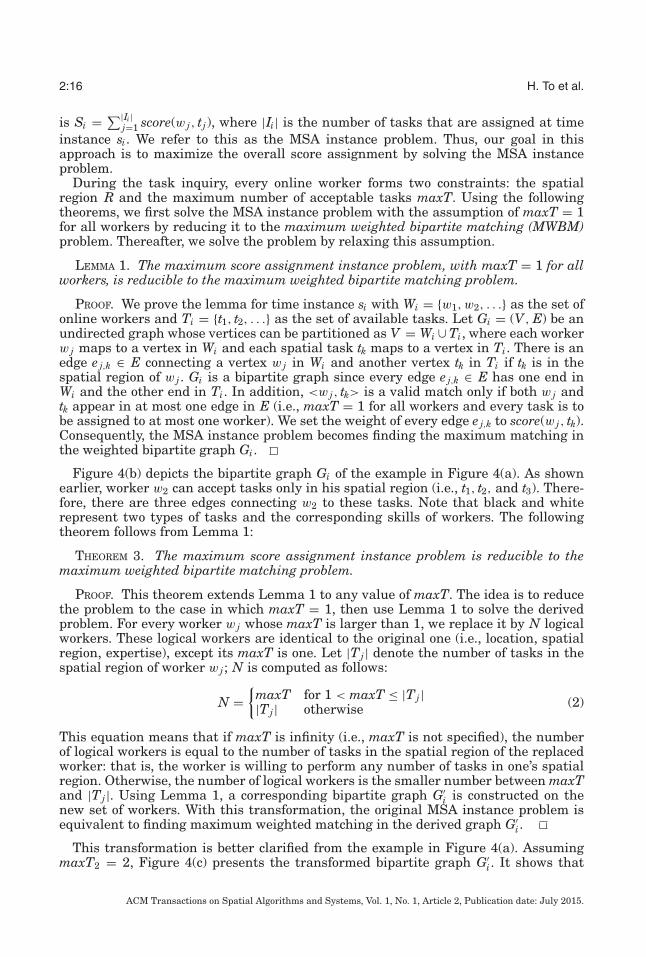
Fig. 4. An example of the reduction of the MSA instance problem to the maximum weighted bipartitematching problem at instance si .
take a high-quality picture. Note that every worker can have multiple skills, but everytask has one and only one type.
Consequently, maximizing the number of assigned tasks is no longer our optimizationgoal. Instead, we introduce the concept of score and formally define the Maximum ScoreAssignment (MSA) problem as follows:
Definition 6.5 (Score). For every match of form <w, t>, we define a score value,score(w, t), which indicates how well the worker w performs the task t based on theworker expertise.
Definition 6.6 (Maximum Score Assignment (MSA)). Given a time interval φ ={s1, s2, . . . , sn}, let Si be the total score assignment at time instance si, that is, Si =∑|Ii |
j=1 score j . The maximum score assignment problem is the process of assigning tasksto the workers during the time interval φ such that the total score
∑ni=1 Si is maximized.
Figure 4(a) shows a set of workers, represented by circles, along with their constraintsand a set of tasks, represented by squares at time instance si. There are two types oftasks and two corresponding workers’ skills (i.e., each worker has one skill), whichare represented by black and white. Every worker w j is associated with a spatialregion Rj , where j = 1, 2, 3. As shown in Figure 4, worker w2 can accept tasks onlyinside his spatial region (i.e., t1, t2 and t3). Moreover, while w2 is willing to accept onlyone task (i.e., maxT2 = 1), w1 and w3 do not limit the number of acceptable tasks (i.e.,maxT1 = maxT3 = ∞). An expertise match between a task and a worker happens whenthe task is inside the spatial region of the worker and they have the same color (i.e.,<w2, t2>). With MSA, a score is defined for every match. In this particular example,the expertise match score is 3, while the scores of all nonexpertise matches are 1. Ouroptimization goal is to maximize the total score assignment.
6.2. Assignment Protocol
Similar to MTA, a global solution to MSA is not feasible unless we are clairvoyant.Instead, the SC-server tries to optimize the task assignment locally at every instanceof time. In the following, we extend three local optimal strategies—Basic, LLEP, andCDP—to the MSA problem.
6.2.1. Basic Strategy. The basic approach uses local optimization at every time instancerather than global optimization: that is, for each time instance si, we have a set of onlineworkers Wi = {w1, w2, . . .} and a set of available tasks Ti = {t1, t2, . . .}. The goal is toassign the tasks to the workers such that the total score is maximized. The total score
ACM Transactions on Spatial Algorithms and Systems, Vol. 1, No. 1, Article 2, Publication date: July 2015.
2:16 H. To et al.
is Si = ∑|Ii |j=1 score(w j, tj), where |Ii| is the number of tasks that are assigned at time
instance si. We refer to this as the MSA instance problem. Thus, our goal in thisapproach is to maximize the overall score assignment by solving the MSA instanceproblem.
During the task inquiry, every online worker forms two constraints: the spatialregion R and the maximum number of acceptable tasks maxT. Using the followingtheorems, we first solve the MSA instance problem with the assumption of maxT = 1for all workers by reducing it to the maximum weighted bipartite matching (MWBM)problem. Thereafter, we solve the problem by relaxing this assumption.
LEMMA 1. The maximum score assignment instance problem, with maxT = 1 for allworkers, is reducible to the maximum weighted bipartite matching problem.
PROOF. We prove the lemma for time instance si with Wi = {w1, w2, . . .} as the set ofonline workers and Ti = {t1, t2, . . .} as the set of available tasks. Let Gi = (V, E) be anundirected graph whose vertices can be partitioned as V = Wi ∪ Ti, where each workerw j maps to a vertex in Wi and each spatial task tk maps to a vertex in Ti. There is anedge e j,k ∈ E connecting a vertex w j in Wi and another vertex tk in Ti if tk is in thespatial region of w j . Gi is a bipartite graph since every edge e j,k ∈ E has one end inWi and the other end in Ti. In addition, <w j, tk> is a valid match only if both w j andtk appear in at most one edge in E (i.e., maxT = 1 for all workers and every task is tobe assigned to at most one worker). We set the weight of every edge e j,k to score(w j, tk).Consequently, the MSA instance problem becomes finding the maximum matching inthe weighted bipartite graph Gi.
Figure 4(b) depicts the bipartite graph Gi of the example in Figure 4(a). As shownearlier, worker w2 can accept tasks only in his spatial region (i.e., t1, t2, and t3). There-fore, there are three edges connecting w2 to these tasks. Note that black and whiterepresent two types of tasks and the corresponding skills of workers. The followingtheorem follows from Lemma 1:
THEOREM 3. The maximum score assignment instance problem is reducible to themaximum weighted bipartite matching problem.
PROOF. This theorem extends Lemma 1 to any value of maxT. The idea is to reducethe problem to the case in which maxT = 1, then use Lemma 1 to solve the derivedproblem. For every worker w j whose maxT is larger than 1, we replace it by N logicalworkers. These logical workers are identical to the original one (i.e., location, spatialregion, expertise), except its maxT is one. Let |Tj | denote the number of tasks in thespatial region of worker w j ; N is computed as follows:
N ={
maxT for 1 < maxT ≤ |Tj ||Tj | otherwise (2)
This equation means that if maxT is infinity (i.e., maxT is not specified), the numberof logical workers is equal to the number of tasks in the spatial region of the replacedworker: that is, the worker is willing to perform any number of tasks in one’s spatialregion. Otherwise, the number of logical workers is the smaller number between maxTand |Tj |. Using Lemma 1, a corresponding bipartite graph G′
i is constructed on thenew set of workers. With this transformation, the original MSA instance problem isequivalent to finding maximum weighted matching in the derived graph G′
i.
This transformation is better clarified from the example in Figure 4(a). AssumingmaxT2 = 2, Figure 4(c) presents the transformed bipartite graph G′
i. It shows that
ACM Transactions on Spatial Algorithms and Systems, Vol. 1, No. 1, Article 2, Publication date: July 2015.
A Server-Assigned Spatial Crowdsourcing Framework 2:17
the worker w2 whose maxT2 = 2 was replaced by two identical workers w′2 whose
maxT = 1.With these reductions, we can now use any algorithm for maximum weighted bipar-
tite matching to solve the MSA instance problem. One of the well-known methods tocompute weighted matching is the Hungarian algorithm [Papadimitriou and Steiglitz1998]. The input of the Hungarian algorithm is a matrix of the costs. Thus, we need topresent the bipartite graph G as a matrix of size |W | × |T |, in which the workers andthe tasks are represented as rows and columns, respectively. Each cost in the matrix isnegative score value of each match. Consequently, in order to solve the MSA problem,we repeat the MSA instance problem for every instance of time.
With the Basic approach, MSA at every instance of time does not necessarily result ina globally optimal answer due to its local optimization. To improve the Basic strategy,we now present two spatial heuristics in turn.
6.2.2. Least Location Entropy Priority (LLEP). As mentioned in Section 6.2.1, the problemwith the Basic approach is that at every instance of time, it tries to maximize onlythe current assignment without considering future optimizations. Thus, we can usesome heuristics to maximize the overall assignments. One of the heuristics is to exploitthe spatial characteristics of the environment during the assignment, one of which isthe distribution of the workers in that area. Similar to Section 5.2.2, we use locationentropy as the indicator of worker density.
Our goal in this approach is to maximize the total score during every instance of timewhile the total cost associated to the assigned tasks is the lowest. With the followingtheorem, we can solve the minimum-cost MSA instance problem by reducing it to theminimum-cost MWBM, that is, finding the MWBM of minimum total cost.
THEOREM 4. The minimum-cost maximum score assignment instance problem isreducible to the minimum-cost maximum weighted bipartite matching problem.
PROOF. We prove this theorem for time instance si with Wi = {w1, w2, . . .} as the setof online workers, and Ti = {t1, t2, . . .} as the set of available tasks. Let G′
i = (V, E)be the weighted bipartite graph constructed in the proof of Theorem 3. Note that theweight of every edge e j,k is score(w j, tk). We associate to every edge e j,k ∈ E the cost of tk,which is the entropy of location lk (i.e., Entropy(lk)). Thus, by finding the minimum-costmaximum score in graph G′
i, we have assigned the maximum score with the minimumcost.
In the example of Figure 4(c), let Entropy(l2) be the location entropy of the spatialtask t2. Since t2 is located in the spatial regions of all workers, we set the cost of all theedges connecting to t2 to Entropy(l2).
According to Theorem 4, solving our problem is equivalent to solving minimum-cost MWBM at every time instance. In order to solve this problem, our approachis to first find the maximum matching using any algorithm that computes MWBM(e.g., Hungarian algorithm). Thereafter, the cost of the matching can be minimized byapplying an Integer Programming technique (e.g., branch and bound technique).
Let G = (V, E) be an undirected graph constructed in the proof of Theorem 3. Everyedge e j,k ∈ E, which connects a worker w j and a task tk, has a cost c j,k. This cost isthe location entropy of the task’s location lk, computed by Equation (1). Let xj,k be anindicator variable for each edge e j,k such that
xj,k ={
1 if the edge e j,k ∈ M0 otherwise
ACM Transactions on Spatial Algorithms and Systems, Vol. 1, No. 1, Article 2, Publication date: July 2015.
2:18 H. To et al.
where M is any matching of G. Let fmax be the total score of Mmax. The goal is tominimize the total cost of the matching, which can be formulated as follows:
min∑j,k
xj,kc j,k
s.t :∑j,k
xj,kw j,k = fmax; xj,k ∈ {0, 1}
∀w j ∈ Wi,∑
k
xj,k ≤ 1; ∀tk ∈ Ti,∑
j
x j,k ≤ 1
This is a mixed integer programming problem. Using the branch and bound techniqueoffered by ILOG CPLEX [2007], in our particular experiments, we can find the optimalsolution to the MSA instance problem with thousands of workers and tasks within afew seconds. However, finding the global optimal solution across many time instancesis a much more complex problem, as the number of variables is very large (i.e., xjkt,where j, k, and t represent the dimensions of worker, task, and time, respectively). Thecomputation challenge of this problem is beyond the scope of this work.
Finally, our LLEP strategy solves the MSA problem by computing the minimum-costmaximum-score problem for every time instance.
6.2.3. Close Distance Priority (CDP). As presented in Section 5.2.3, with the CDP strategy,we incorporate the travel cost of the workers in the assignment process. Our goal isto maximize the total score at every time instance while minimizing the travel costof the workers whenever possible. We defined the travel cost between a worker w anda spatial task t as the Euclidean distance between the two, denoted by d(w, t). Bycomputing the travel cost of every match <w, t>, we can associate to every pair thecorresponding cost. Similar to the LLEP approach, our goal in CDP is to maximizethe total score during every time instance, while the total cost of the selected edgesis the lowest. This means that the matches with lower costs are likely to be selectedfirst. Similarly, the problem turns into the minimum-cost MWBM instance problem;therefore, a similar solution to that of Section 6.2.2 but with a different cost functioncan be applied to solve this problem.
We now show that MSA is a generalized MTA with Theorem 5. Assuming the scoresof all expertise matches are equal and the scores of all nonexpertise matches are equal,the effect of the expertise match score is as follows.
THEOREM 5. Maximum score assignment instance results in maximum expertisematches if the expertise match score is higher than double that of the nonexpertisematch score.
PROOF. We first assume that maxT = 1 for all workers. Let Mmax be the optimalsolution of the MSA instance problem. If there exists an unassigned expertise match<w, t> in Mmax whose both ends w and t are not in any other assigned expertise match,to increase the total score we can always replace at most two assigned nonexpertisematches by <w, t>. On the other hand, if there does not exist an unassigned expertisematch in Mmax, the number of expertise matches in Mmax is already maximized. Thus,MSA instance results in maximum expertise matches in the case of maxT = 1 for allworkers. If maxT is larger than 1, we can use Theorem 3 to reduce the problem to thecase of maxT = 1.
7. PERFORMANCE EVALUATION
We conducted several experiments on both real-world and synthetic data to evaluatethe performance of our proposed approaches: Basic, LLEP, and CDP. Since the MTA
ACM Transactions on Spatial Algorithms and Systems, Vol. 1, No. 1, Article 2, Publication date: July 2015.
A Server-Assigned Spatial Crowdsourcing Framework 2:19
Table I. Distribution of the Synthetic Data for W/T
problem is a special case of the MSA problem, we will evaluate MSA that subsumesMTA6. Here, we discuss our experimental methodology. Next, we present our experi-mental results.
7.1. Experimental Methodology
We performed four sets of experiments. In the first two sets, we evaluated the scalabilityof our proposed approaches by varying both the average number of workers whosespatial regions contain a given spatial task, namely, workers per task (W/T), and theaverage number of spatial tasks that are inside the spatial region of a given worker,denoted by tasks per worker (T/W). Similar results were observed for varying bothT/W and W/T since T/W grows as W/T increases. Hereafter, we present the resultsfor varying W/T only. In the third set of experiments, we evaluated the impacts of theworkers’ constraints on the performance of our approaches. Note that every worker hastwo constraints: R and maxT. However, we evaluated the impact of only one (i.e., maxT)on our approaches, since both constraints have similar effects. Finally, to evaluate theimpact of the expertise match score, we used three performance measures: (i) theaverage total score per time instance, (ii) the average number of expertise matches pertime instance, and (iii) the average travel cost for a worker to perform a spatial task. Thetravel cost is measured in terms of the Euclidean distance between the worker and thelocation of the task. We conducted our experiments on various synthetic (SYN) and tworeal-world (REAL) datasets. With our synthetic experiments, we used two distributions:uniform (SYN-UNIFORM) and skewed (SYN-SKEWED). In the following, we discussour datasets in more detail.
With the first set of synthetic experiments, in order to evaluate the impact of W/T,we considered three cases (Table I): sparse, medium, and dense. The average numberof W/T is 1, 3, and 5, respectively (i.e., we increased the size of spatial region R toachieve these numbers). This means that we consider an area to be worker-dense ifthe average number of workers who are eligible to perform a single spatial task is 5,whereas in a sparse case, the average number of W/T is 1. In our experiments on SYN-UNIFORM, the average number of W/T varies with a small standard deviation (from1 to 2.2), whereas in our experiments on SYN-SKEWED, the average number of W/Tvaries with a large standard deviation (between 4 to 12). With the uniform distribution(SYN-UNIFORM), both workers and tasks are uniformly distributed, whereas, in orderto generate the SYN-SKEWED dataset, the workers were formed into four Gaussianclusters (with σ = 0.05 and randomly chosen centers) while the tasks were uniformlydistributed.
Since we do not have access to real-world spatial crowdsourcing data, we used real-world data from other applications, namely Gowalla7 and Yelp8, to emulate the spatialcrowdsourcing application. Hence, we used the users in these applications as workers,the point of interests as tasks, and the check-in (for Gowalla) and review (for Yelp) ascompleted tasks. A summary of these datasets is given in Table II.
6For MTA experiments, refer to Kazemi and Shahabi [2012].7snap.stanford.edu/data/loc-gowalla.html.8yelp.com/dataset_challenge.
ACM Transactions on Spatial Algorithms and Systems, Vol. 1, No. 1, Article 2, Publication date: July 2015.
2:20 H. To et al.
Table II. Statistics of the Real Datasets, Gowalla and Yelp
Gowalla YelpNumber of tasks 20,000 11,537Number of workers 10,273 43,873Number of task types 5 508Grid size 50,000×50,000 10,000×10,000Average Number of skills per worker 1 8Average Number of W/T 4 44
Gowalla is a location-based social network in which users are able to check in todifferent spots in their vicinity. The check-ins include the location and the time thatthe users entered the spots. For our experiments, we used the check-in data overa period of 20 days in 2010, including 10,273 spots (e.g., restaurants), covering thestate of California. Moreover, we assumed that Gowalla users are the workers of ourspatial crowdsourcing system, and checking in to a spot is equivalent to accepting aspatial task at that location. We picked the granularity of a time instance as 1 day.Consequently, we assumed all the users who checked in during a day as our availableworkers for that day. Since users may have various check-ins during a day, for everyuser w, we set maxT as the number of check-ins of the user in that day, and we setR as the minimum bounding rectangle of those checked-in locations. Moreover, thespatial tasks were randomly generated for the given spots in the area. In order tocompute the location entropy, we discretized the latitude and longitude space into50,000×50,000 grid (approximately 30×30 meters per grid cell). For every grid cell,we computed location entropy based on Equation (1). The average number of W/T ofGowalla datasets was computed as 4. This also confirms our choices of parameters forthe synthetic datasets.
The Yelp dataset was captured in the greater Phoenix, Arizona, area including loca-tions of 11,537 businesses (e.g., restaurants), 43,873 users, and 229,907 reviews. Forour experiments, we assumed that the businesses are the spatial tasks, Yelp users arethe workers, and reviewing a business is equivalent to accepting a spatial task at itslocation. To elaborate, we assumed that business categories are task types, and skillsets of each worker are the category lists of the businesses that the worker reviewed,referred to as a review list. For each worker, we set R as the minimum bounding rect-angle of the locations of that worker’s review list. Moreover, we set maxT as the size ofthe worker’s review list at one instance of time. With Yelp data, we generated 20 timeinstances by dividing the review time interval into 20 equal periods. Other parametersare shown in Table II.
Finally, in all of our experiments, we fixed the time interval to 20 days and set theduration of every spatial task to 10 days (i.e., φ = 20, δ = 10). Furthermore, withoutloss of generality, unless mentioned otherwise, we set the scores of all expertise matchesto 3 and the scores of all nonexpertise matches to 1. With the SYN experiments, wefixed the number of new workers and the number of new tasks at each instance timeto 500 and 1000, respectively. For all workers, the value of maxT is 20. Furthermore,with SYN and Gowalla datasets, there are 5 values of task types. The type of each taskwas chosen randomly within these values. Moreover, each worker has one and only oneskill, selected randomly from these task types. For each of our experiments, we ran 50cases and reported the average of the results. The experiments were run on an Intel(R)Core(TM)i7-2600 CPU at 3.40GHz with 8GB of RAM.
7.2. Experimental Results
7.2.1. Effect of Number of Workers per Task (W/T). In the first set of experiments, we eval-uated the performance of our approaches by varying the number of workers whose
ACM Transactions on Spatial Algorithms and Systems, Vol. 1, No. 1, Article 2, Publication date: July 2015.
A Server-Assigned Spatial Crowdsourcing Framework 2:21
Fig. 5. Effect of W/T on the synthetic data, per time instance.
Table III. Percentages of Nonassigned Tasks per Time Instance
We measured the average number of assigned tasks over three heuristics: Basic, LLEP and CDP.
spatial regions contain a given spatial task. Figures 5(a), 5(b), 5(d) and 5(e) depict theresult of our experiments on both SYN-UNIFORM and SYN-SKEWED. The figuresshow that the total score and the number of expertise matches increase as the numberof W/T grows. The reason is that more resources become available to perform tasks.Moreover, Figures 5(a) and 5(d) show that LLEP is better than both Basic (GR) andCDP in terms of the average total score (up to 35%) due to applying the location en-tropy heuristic. However, LLEP does not necessarily maximize the number of expertisematches. Figures 5(b) and 5(e) show that CDP is better than the others in terms of thenumber of expertise matches (up to 50%). The reason is that CDP first maximizes thetotal score. It then tries to minimize the total travel cost whenever possible, whichresults in minimizing the number of assigned tasks (i.e., the more tasks assigned, themore total travel cost). As a result, CDP increases the number of expertise matches.
Figure 6 depicts similar experiments using two real datasets. With Gowalla data,Figures 6(a) and 6(b) show that LLEP improves Basic and CDP significantly bothin terms of the total score as well as the number of expertise matches (up to 25%).Similar results are shown on Yelp data. Particularly, Figures 6(d) and 6(e) show thatLLEP outperforms Basic and CDP in task assignment (up to 25%). The superiorityof the LLEP strategy in both cases (e.g., the total score and the number of expertisematches) can be explained by the fact that LLEP took much advantage of locationentropy of the real check-in data. Table III shows that a large number of tasks (about56% for Gowalla, 17% for Yelp, 23% for SYN-UNIFORM, and 71% for SYN-SKEWED)remained unassigned. This happens due to different reasons such as the constraints
ACM Transactions on Spatial Algorithms and Systems, Vol. 1, No. 1, Article 2, Publication date: July 2015.
2:22 H. To et al.
Fig. 6. Effect of W/T on the real data, per time instance.
of the workers (e.g., the covering area of the workers may overlap with only a smallnumber of tasks) or the expiration of the unassigned tasks.
In the next set of experiments, we measured the impact of varying the number W/Ton the average travel cost of the workers in performing a given task in each algorithm.Figures 5(c), 5(f), 6(c), and 6(f) depict the result of our experiments on both SYN andREAL data. As Figures 5(c) and 5(f) show, the average travel cost of the workers in-creases in all cases because as the number of W/T grows, more tasks are assigned, inwhich some tasks farther away can result in high average travel distance. In addition,we observed that CDP improves the travel cost of the workers significantly as comparedwith Basic (GR) and LLEP in both SYN and REAL data, which demonstrates the effec-tiveness of the travel cost heuristic. Particularly, Figures 5(c) and 5(f) show 50% and70% improvements of CDP as compared with the Basic approach in SYN-UNIFORMand SYN-SKEWED, respectively. Moreover, Figures 6(c) and 6(f) demonstrate thatCDP improves the travel cost of the workers in Gowalla and Yelp data by 90% and70%, respectively.
7.2.2. Effect of Worker’s Constraints. We evaluated the performance of our approacheswith respect to expanding the spatial region of every worker R. In addition, we reportedonly our experiments on SYN-UNIFORM since similar trends were observed for theskewed distribution. As Figure 7(a) shows, as we vary the size of R from [1%×1%]to [3%×3%] of the entire area, the total score increases. The reason is that largerspatial regions cover larger numbers of spatial tasks. Consequently, the number oftasks per worker, that is, T/W, increases, which leads to more tasks being available tobe performed by workers. Next, Figure 7(b) shows the effect of varying R on the travelcost. The figure illustrates that the travel cost increases with the expansion of R. This
ACM Transactions on Spatial Algorithms and Systems, Vol. 1, No. 1, Article 2, Publication date: July 2015.
A Server-Assigned Spatial Crowdsourcing Framework 2:23
Fig. 7. Effect of spatial region R, per time instance: SYN-UNIFORM.
Fig. 8. Effect of score, per time instance: SYN-UNIFORM.
is because when R grows, tasks farther away could be assigned, which leads to theincrease in travel cost.
7.2.3. Effect of Expertise Match Score. Next, we evaluated the impact of varying theexpertise match score on MSA with the SYN-UNIFORM data. Figures 8(a) and 8(b)show that as we vary the expertise match score from 1 to 3, the number of assignedtasks decreases while the number of expertise matches grows. The reason is thatwhen expertise match and nonexpertise match scores are equal, MSA reduces to theMTA problem, which maximizes the number of assigned tasks. Moreover, as provedin Theorem 5, when the expertise match score is more than two times the score ofa nonexpertise match, the number of expertise matches is maximized. This meansthat by varying the expertise match score from 1 to any value that is greater than 2,we can flexibly change our optimization goal from maximizing the assigned tasks tomaximizing the expertise matches.
To summarize, the main observation from this set of experiments is that LLEPoutperforms both Basic and CDP in terms of the overall task assignment (i.e., thetotal score), while the CDP approach is superior in terms of travel cost. The nonspatialgreedy algorithm (i.e., Basic) achieves optimal assignment per time instance, given thelocal knowledge up to that time instance. However, a simple heuristic that predicts thespatial distribution of the workers in the future using their past location entropy, thatis, LLEP, achieves 35% improvement over Basic. Meanwhile, another simple heuristicthat gives priority to the distance traveled by the workers, that is, CDP, achieves 90%superiority over Basic in terms of travel cost. This shows the importance of considering
ACM Transactions on Spatial Algorithms and Systems, Vol. 1, No. 1, Article 2, Publication date: July 2015.
2:24 H. To et al.
Fig. 9. Comparison of our approaches with the Ranking algorithm on the synthetic datasets.
the spatial aspect of our problems, that is, MSA, when devising new solutions. Thus,based on the objective of the spatial crowdsourcing application (i.e., maximizing theassignment or minimizing travel cost), either of the LLEP or CDP approaches can beselected.
7.2.4. Fixing the Worker Set (Online Matching). In the final set of experiments, we comparedthe performance of Basic and LLEP with the Ranking algorithm to the online bipartitematching problem [Karp et al. 1990]9. In order to compare our heuristics with Ranking,we needed to modify our experimental setup so that the worker set is known in advance(i.e., we fixed the worker set and varied the task set at every time instance). For thiscomparison, each worker can only perform one task, maxT = 1. Other values of maxTcan be reducible to the case of maxT = 1, as shown in Theorem 3. With the syntheticdatasets, the worker set size is 500 while the task set size is 25 per time instance.With real datasets, we merged 20 worker sets from the previous experiments and keptthe task sets the same. This merging results in the worker set sizes of Gowalla andYelp being 25,000 and 10,000, respectively. Other parameters—the number of timeinstances and the task duration—are the same as before.
Figure 9 presents the results for the synthetic datasets. Figure 9(a) shows that thenumber of assigned tasks increases for all algorithms as the sizes of the spatial regionsof the workers increase. The reason is that as the spatial regions expand, a task canbe performed by many workers. Particularly, LLEP and Basic approaches outperformthe Ranking algorithm by up to 60%. Figure 9(b) shows a similar trend, except thata higher number of assigned tasks is observed in SYN-UNIFORM. This difference isbecause most of the tasks are covered by many workers in SYN-UNIFORM while inSYN-SKEWED, a few tasks are covered by a large number of workers, yet the othersmay not be covered by any worker.
Figure 10 depicts the comparison for the real datasets. First, the number of assignedtasks in Gowalla (2500-3000) is smaller than that in Yelp (6000-10,000). The reasonis that W/T in Yelp is much higher than that in Gowalla. As a result, one task can beassigned to many workers, which means that the derived bipartite graph in Figure 4(b)is denser and its search space is larger. Another observation is that the Rankingalgorithm performs as well as Basic and LLEP in Gowalla data (Figure 10(a)) whileit does not perform as well in Yelp data (Figure 10(b)). LLEP improves Rank by 46%.This result suggests that our heuristics result in much better assignments than theRanking algorithm in the large search space.
9This randomized solution does not use any spatial knowledge and has a competitive ratio of 0.63.
ACM Transactions on Spatial Algorithms and Systems, Vol. 1, No. 1, Article 2, Publication date: July 2015.
A Server-Assigned Spatial Crowdsourcing Framework 2:25
Fig. 10. Comparison of our approaches with the Ranking algorithm on the real datasets.
To summarize, the solutions to online bipartite matching, such as Ranking, aresimplistic (e.g., assuming the arrival of one item at a time) as the goal is to finda performance bounded by computing competitive ratio, which is different from ourobjective to devise practical heuristics for a real-world problem.
8. CONCLUSION
In this article, we introduced spatial crowdsourcing as the process of crowdsourcing aset of spatial tasks to a set of workers. We formally defined the MTA problem and itsextension, MSA, which considers worker expertise. Subsequently, we proposed threesolutions to MTA and MSA: Basic, LLEP, and CDP. In our experiments on both realand synthetic data, we show the superiority of our heuristics LLEP and CDP in maxi-mizing the overall task assignment and minimizing the travel cost, respectively, whencompared to the Basic approach. We also compared our approaches with the Rankingalgorithm for solving a variant of the online bipartite matching problem in which eachtask has a deadline. Experimental results show that our solutions outperform Rankingin maximizing the number of assigned tasks.
The main contribution of this article is on the formulation of the MTA and MSAproblems, their formalization, and the heuristics proposed to solve them. The mainlesson learned is that a greedy algorithm that achieves optimal assignment per timeinstance without any spatial consideration, that is, Basic, is not the best approach tosolve the spatial crowdsourcing problem. Instead, a heuristic that predicts the spatialdistribution of the workers in future, using their past location entropy (i.e., LLEP), ora heuristic that gives priority to the distances traveled by the workers, that is, CDP,outperforms the nonspatial greedy approach.
REFERENCES
Omar Alonso, Daniel E. Rose, and Benjamin Stewart. 2008. Crowdsourcing for relevance evaluation. In ACMSigIR Forum, Vol. 42. ACM, New York, NY, 9–15.
Florian Alt, Alireza Sahami Shirazi, Albrecht Schmidt, Urs Kramer, and Zahid Nawaz. 2010. Location-basedcrowdsourcing: Extending crowdsourcing to the real world. In Proceedings of the 6th Nordic Conferenceon Human–Computer Interaction: Extending Boundaries. ACM, New York, NY, 13–22.
Amazon Mechanical Turk. 2005. http://www.mturk.com/.Alessandro Bozzon, Marco Brambilla, and Stefano Ceri. 2012. Answering search queries with crowdsearcher.
In Proceedings of the 21st International Conference on World Wide Web. ACM, New York, NY, 1009–1018.
ACM Transactions on Spatial Algorithms and Systems, Vol. 1, No. 1, Article 2, Publication date: July 2015.
Muhammed Fatih Bulut, Yavuz Selim Yilmaz, and Murat Demirbas. 2011. Crowdsourcing location-basedqueries. In 2011 IEEE International Conference onPervasive Computing and Communications Workshops(PERCOM Workshops). IEEE, 513–518.
Kuan-Ta Chen, Chen-Chi Wu, Yu-Chun Chang, and Chin-Laung Lei. 2009. A crowdsourceable QoE evalu-ation framework for multimedia content. In Proceedings of the 17th ACM International Conference onMultimedia. ACM, New York, NY, 491–500.
Cory Cornelius, Apu Kapadia, David Kotz, Dan Peebles, Minho Shin, and Nikos Triandopoulos. 2008. Anony-sense: Privacy-aware people-centric sensing. In Proceedings of the 6th International Conference on MobileSystems, Applications, and Services. ACM, New York, NY, 211–224.
Justin Cranshaw, Eran Toch, Jason Hong, Aniket Kittur, and Norman Sadeh. 2010. Bridging the gap betweenphysical location and online social networks. In Proceedings of the 12th ACM International Conferenceon Ubiquitous Computing. ACM, New York, NY, 119–128.
Crowdflower. 2009. http://www.crowdflower.com/.Hung Dang, Tuan Nguyen, and Hien To. 2013. Maximum complex task assignment: Towards tasks corre-
lation in spatial crowdsourcing. In Proceedings of International Conference on Information Integrationand Web-based Applications & Services. ACM, New York, NY, 77.
Gianluca Demartini, Beth Trushkowsky, Tim Kraska, and Michael J. Franklin. 2013. CrowdQ: Crowdsourcedquery understanding. In CIDR.
Dingxiong Deng, Cyrus Shahabi, and Ugur Demiryurek. 2013. Maximizing the number of worker’s self-selected tasks in spatial crowdsourcing. In Proceedings of the 21st ACM SIGSPATIAL InternationalConference on Advances in Geographic Information Systems. ACM, New York, NY, 314–323.
Field Agent. 2010. http://www.fieldagent.net/.Michael J. Franklin, Donald Kossmann, Tim Kraska, Sukriti Ramesh, and Reynold Xin. 2011. CrowdDB: An-
swering queries with crowdsourcing. In Proceedings of the 2011 ACM SIGMOD International Conferenceon Management of Data. ACM, New York, NY, 61–72.
Gigwalk. 2010. http://gigwalk.com/.GoogleMapMaker. 2008. http://www.google.com/mapmaker/.Ido Guy, Adam Perer, Tal Daniel, Ohad Greenshpan, and Itai Turbahn. 2011. Guess who?: Enriching the
social graph through a crowdsourcing game. In Proceedings of the SIGCHI Conference on Human Factorsin Computing Systems. ACM, New York, NY, 1373–1382.
Seth Hettich and Michael J. Pazzani. 2006. Mining for proposal reviewers: Lessons learned at the NationalScience Foundation. In Proceedings of the 12th ACM SIGKDD International Conference on KnowledgeDiscovery and Data Mining. ACM, New York, NY, 862–871.
Bret Hull, Vladimir Bychkovsky, Yang Zhang, Kevin Chen, Michel Goraczko, Allen Miu, Eugene Shih, HariBalakrishnan, and Samuel Madden. 2006. CarTel: A distributed mobile sensor computing system. InProceedings of the 4th International Conference on Embedded Networked Sensor Systems. ACM, NewYork, NY, 125–138.
ILOG CPLEX. 2007. 11.0 Users Manual. ILOG SA, Gentilly, France.Bala Kalyanadundaram and Kirk R. Pruhs. 1993. Online weighted matching. Journal of Algorithms (1993),
478–488. Issue 3.Bala Kalyanasundaram and Kirk R. Pruhs. 2000. An optimal deterministic algorithm for online b-matching.
Theoretical Computer Science 233, 1, 319–325.Richard M. Karp, Umesh V. Vazirani, and Vijay V. Vazirani. 1990. An optimal algorithm for on-line bipartite
matching. 352–258.Leyla Kazemi and Cyrus Shahabi. 2011. A privacy-aware framework for participatory sensing. ACM SIGKDD
Explorations Newsletter 13, 1, 43–51.Leyla Kazemi and Cyrus Shahabi. 2012. GeoCrowd: Enabling query answering with spatial crowdsourcing.
In Proceedings of the 20th International Conference on Advances in Geographic Information Systems.ACM, New York, NY, 189–198.
Leyla Kazemi, Cyrus Shahabi, and Lei Chen. 2013. Geotrucrowd: Trustworthy query answering with spatialcrowdsourcing. In Proceedings of the 21st ACM SIGSPATIAL International Conference on Advances inGeographic Information Systems. ACM, New York, NY, 314–323.
Samir Khuller, Stephen G. Mitchell, and Vijay V. Vazirani. 1994. On-line algorithms for weighted bipartitematching and stable marriages. Theoretical Computer Science 2, 255–267.
Aniket Kittur, Jeffrey V. Nickerson, Michael Bernstein, Elizabeth Gerber, Aaron Shaw, John Zimmerman,Matt Lease, and John Horton. 2013. The future of crowd work. In Proceedings of the 2013 Conference onComputer Supported Cooperative Work. ACM, New York, NY, 1301–1318.
Jon Kleinberg and Eva Tardos. 2006. Algorithm design. Pearson Education India, Delhi, India.
ACM Transactions on Spatial Algorithms and Systems, Vol. 1, No. 1, Article 2, Publication date: July 2015.
A Server-Assigned Spatial Crowdsourcing Framework 2:27
Eugene L. Lawler, Jan Karel Lenstra, A. H. G. Rinnooy Kan, and David B. Shmoys. 1985. The TravelingSalesman Problem: A Guided Tour of Combinatorial Optimization. Vol. 3. Wiley, New York, NY.
Xuan Liu, Meiyu Lu, Beng Chin Ooi, Yanyan Shen, Sai Wu, and Meihui Zhang. 2012. CDAS: A crowdsourcingdata analytics system. Proceedings of the VLDB Endowment 5, 10, 1040–1051.
Adam Marcus, Eugene Wu, David Karger, Samuel Madden, and Robert Miller. 2011. Human-powered sortsand joins. Proceedings of the VLDB Endowment 5, 1, 13–24.
Aranyak Mehta, Amin Saberi, Umesh Vazirani, and Vijay Vazirani. 2007. Adwords and generalized onlinematching. Journal of the ACM (JACM) 54, 5, 22.
David Mimno and Andrew McCallum. 2007. Expertise modeling for matching papers with reviewers. InProceedings of the 13th ACM SIGKDD International Conference on Knowledge Discovery and DataMining. ACM, New York, NY, 500–509.
Prashanth Mohan, Venkata N. Padmanabhan, and Ramachandran Ramjee. 2008. Nericell: Rich monitoringof road and traffic conditions using mobile smartphones. In Proceedings of the 6th ACM Conference onEmbedded Network Sensor Systems. ACM, New York, NY, 323–336.
Mohamed Musthag and Deepak Ganesan. 2013. Labor dynamics in a mobile micro-task market. In Pro-ceedings of the SIGCHI Conference on Human Factors in Computing Systems. ACM, New York, NY,641–650.
oDesk. 2005. https://www.odesk.com/.OpenStreetMap. 2004. http://www.openstreetmap.org/.Christos H. Papadimitriou and Kenneth Steiglitz. 1998. Combinatorial Optimization: Algorithms and Com-
plexity. Courier Dover Publications, Mineola, NY.Aditya Parameswaran, Anish Das Sarma, Hector Garcia-Molina, Neoklis Polyzotis, and Jennifer Widom.
2011. Human-assisted graph search: it’s okay to ask questions. Proceedings of the VLDB Endowment 4,5, 267–278.
Aditya G. Parameswaran, Hector Garcia-Molina, Hyunjung Park, Neoklis Polyzotis, Aditya Ramesh, andJennifer Widom. 2012. Crowdscreen: Algorithms for filtering data with humans. In Proceedings of the2012 ACM SIGMOD International Conference on Management of Data. ACM, New York, NY, 361–372.
Layla Pournajaf, Li Xiong, Vaidy Sunderam, and Slawomir Goryczka. 2014. Spatial task assignment forcrowd sensing with cloaked locations. In 2014 IEEE 15th International Conference on Mobile DataManagement (MDM), Vol. 1. IEEE, 73–82.
Alexander J. Quinn and Benjamin B. Bederson. 2011. Human computation: A survey and taxonomy of agrowing field. In Proceedings of the SIGCHI Conference on Human Factors in Computing Systems. ACM,New York, NY, 1403–1412.
Rion Snow, Brendan O’Connor, Daniel Jurafsky, and Andrew Y. Ng. 2008. Cheap and fast—but is it good?:Evaluating non-expert annotations for natural language tasks. In Proceedings of the Conference onEmpirical Methods in Natural Language Processing. Association for Computational Linguistics, 254–263.
Alexander Sorokin and David Forsyth. 2008. Utility data annotation with Amazon Mechanical Turk. In IEEEComputer Society Conference on Computer Vision and Pattern Recognition Workshops, 2008 (CVPRW’08).IEEE, 1–8.
Yong-Hong Sun, Jian Ma, Zhi-Ping Fan, and Jun Wang. 2008. A hybrid knowledge and model approach forreviewer assignment. Expert Systems with Applications 34, 2, 817–824.
Wenbin Tang, Jie Tang, Tao Lei, Chenhao Tan, Bo Gao, and Tian Li. 2012. On optimization of expertisematching with various constraints. Neurocomputing 76, 1, 71–83.
Hien To, Gabriel Ghinita, and Cyrus Shahabi. 2014. A framework for protecting worker location privacy inspatial crowdsourcing. Proceedings of the VLDB Endowment 7, 10.
Hien To, Gabriel Ghinita, and Cyrus Shahabi. 2015. PrivGeoCrowd: A toolbox for studying private spatialcrowdsourcing. Proceedings of the 31st IEEE International Conference on Data Engineering.
Paolo Toth and Daniele Vigo. 2001. The vehicle routing problem. Siam, Philadelphia, PA.UCB. 2008. http://traffic.berkeley.edu/.Umair ul Hassan and Edward Curry. 2014. A multi-armed bandit approach to online spatial task assignment.
In 11th IEEE International Conference on Ubiquitous Intelligence and Computing (UIC’14).Kasturi R. Varadarajan. 1998. A divide-and-conquer algorithm for min-cost perfect matching in the plane.
In Proceedings of the 39th Annual Symposium on Foundations of Computer Science 1998. IEEE, 320–329.
Luis Von Ahn and Laura Dabbish. 2008. Designing games with a purpose. Communications of the ACM 51,8, 58–67.
ACM Transactions on Spatial Algorithms and Systems, Vol. 1, No. 1, Article 2, Publication date: July 2015.
Jiannan Wang, Tim Kraska, Michael J. Franklin, and Jianhua Feng. 2012. Crowder: Crowdsourcing entityresolution. Proceedings of the VLDB Endowment 5, 11, 1483–1494.
Jacob Whitehill, Ting-fan Wu, Jacob Bergsma, Javier R. Movellan, and Paul L. Ruvolo. 2009. Whose voteshould count more: Optimal integration of labels from labelers of unknown expertise. In Advances inNeural Information Processing Systems. 2035–2043.
Wikimapia. 2006. http://wikimapia.org/.Raymond Chi-Wing Wong, Yufei Tao, Ada Wai-Chee Fu, and Xiaokui Xiao. 2007. On efficient spatial matching.
In Proceedings of the 33rd International Conference on Very Large Data Bases. VLDB Endowment, 579–590.
Tingxin Yan, Vikas Kumar, and Deepak Ganesan. 2010. Crowdsearch: Exploiting crowds for accurate real-time image search on mobile phones. In Proceedings of the 8th International Conference on MobileSystems, Applications, and Services. ACM, New York, NY, 77–90.
Man Lung Yiu, Kyriakos Mouratidis, Nikos Mamoulis, and others. 2008. Capacity constrained assignment inspatial databases. In Proceedings of the 2008 ACM SIGMOD International Conference on Managementof Data. ACM, New York, NY, 15–28.
Zhou Zhao, Wilfred Ng, and Zhijun Zhang. 2013. CrowdSeed: Query processing on microblogs. In Proceedingsof the 16th International Conference on Extending Database Technology. ACM, New York, NY, 729–732.
Received November 2013; revised September 2014; accepted January 2015
ACM Transactions on Spatial Algorithms and Systems, Vol. 1, No. 1, Article 2, Publication date: July 2015.