37
A Study of Gentrification and Displacement in North Denver Neighborhoods Douglas C. Holland
A Study of Gentrification and Displacement in North Denver Neighborhoods
Douglas C. Holland
1
Abstract
This study explores gentrification and displacement of vulnerable residents that may be
happening in the Denver neighborhoods of Globeville and Elyria-Swansea. These neighborhoods
contain an underprivileged, mostly Latino population. They have endured poverty, poor street
connectivity, substandard sidewalks and lights, and vehicular pollution. A series of public
projects are planned for these neighborhoods, including a major expansion to Interstate 70, a
renovation of the National Western Center, and construction of new commuter rail lines with
three new stations in Globeville and Elyria-Swansea. These projects may stimulate gentrification
with displacement of underprivileged residents in these neighborhoods. These projects will also
displace Globeville and Elyria-Swansea residents through the demolition of homes and
businesses in the way of these projects.
Existing literature shows only a moderate correlation between gentrification and displacement of
vulnerable residents. The literature also indicates there is a correlation between public
investments and gentrification. Specifically, public transit infrastructure is linked with
gentrification and displacement. Other literature suggests that collaborative public administration
approaches may be used to promote neighborhood revitalization in a way that mitigates
displacement.
Using methodology from a study of Portland, Oregon by Lisa Bates, this study seeks to
determine the extent to which gentrification may be affecting Globeville and Elyria-Swansea.
This study used data from the 1990 and 2000 U.S. Census, the 2008-2012 American Community
Survey (ACS) 5-year data set, and the Housing and Urban Development 2012 Comprehensive
Housing Affordability Strategy (CHAS) data set. Geographic Information System (GIS)
2
technology was used to examine demographics for the neighborhoods including ethnicity,
educational attainment, incomes, and housing values over time. These demographics were used
to classify neighborhoods based on their state of gentrification.
The results of this study indicated that these two neighborhoods were susceptible to
gentrification, and had populations that were highly vulnerable to displacement. However,
gentrification and displacement were not observed in Globeville and Elyria-Swansea with the
existing data sets, which only contained data up to 2012. On the other hand, ground observations,
and the planned development of multiple public projects in these neighborhoods suggest that
rapid gentrification and displacement may already have started in the time since the data was
collected.
Recommendations include collecting and monitoring current demographic data in Globeville and
Elyria-Swansea, to observe gentrification as it happens. Another recommendation is using
existing data, such as Denver’s parcels data set, as a source of current data for future analysis.
Modification of the Bates methodology could be done to make gentrification analysis possible at
the census block group level. Because three light rail stations are planned or under construction
in these neighborhoods, the last recommendation is to study the effects of public investments on
gentrification, focusing on public transit.
Future studies could analyze gentrification on a more granular level, using census block groups,
though this would require changing the data sources and methodology. Other data sources, such
as the Denver’s parcels data set, could provide more current data that would be useful for
studying gentrification and displacement.
3
Introduction
Lisa Bates defined gentrification, in her study of Portland, Oregon, as the rise in property values,
and the change in demographic and economic conditions in neighborhoods, when those changes
are part of a shift from lower-income to higher-income households. These changes often are
accompanied with changes in racial and ethnic makeup of a neighborhood’s residents and
businesses (Bates, 2013, pp. 9–10).
Gentrification takes place when a neighborhood with low real-estate values becomes attractive to
investors and higher-income households. When that happens, they start acquiring property, and
outbid current lower-income residents and businesses. In many cases, existing residents become
displaced. They are forced to move out of the neighborhood when rents and other costs become
unaffordable. They move to other neighborhoods with fewer services and problems including
concentrated poverty and high crime rates. In other cases, public projects, which may initiate
gentrification, or may be caused by demand due to gentrification, may displace residents. For
example, homes may be taken by eminent domain for highways. Finally, some residents may
remain in the neighborhood but suffer harm to their quality of life, when the local cost of living
increases to where it strains their resources. Bates, for the purposes of her study, chose to focus
exclusively on displacement (Bates, 2013, pp. 9–11).
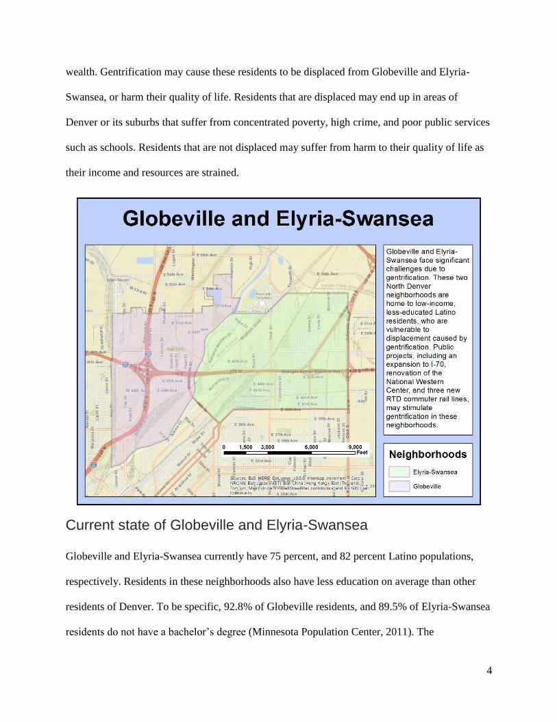
The Denver neighborhoods of Globeville and Elyria-Swansea may be facing gentrification, with
displacement of vulnerable residents, due to upcoming investments, including the redevelopment
of the National Western Center, the expansion of Interstate 70, and the construction of three new
FasTracks commuter rail lines. While these investments may result in a welcome improvement
in the economy of these neighborhoods, many of the present residents may not share in the new
4
wealth. Gentrification may cause these residents to be displaced from Globeville and Elyria-
Swansea, or harm their quality of life. Residents that are displaced may end up in areas of
Denver or its suburbs that suffer from concentrated poverty, high crime, and poor public services
such as schools. Residents that are not displaced may suffer from harm to their quality of life as
their income and resources are strained.
Current state of Globeville and Elyria-Swansea
Globeville and Elyria-Swansea currently have 75 percent, and 82 percent Latino populations,
respectively. Residents in these neighborhoods also have less education on average than other
residents of Denver. To be specific, 92.8% of Globeville residents, and 89.5% of Elyria-Swansea
residents do not have a bachelor’s degree (Minnesota Population Center, 2011). The
5
neighborhoods are plagued by high levels of poverty, with 78.2% of households in Globeville,
and 71.9% in Elyria-Swansea living below 80% of HUD-adjusted Median Family Income
(HAMFI) (U.S. Department of Housing and Urban Development, 2012).
The neighborhoods are divided by Interstate highways 25 and 70, leaving areas of these
neighborhoods poorly connected with each other. Residents have health problems such as asthma
because of pollution, including ozone, from vehicles on I-70 and I-25 and nearby industrial
operations. The neighborhoods also have poorly maintained streets and infrastructure. The
neighborhoods currently have no full-service grocery stores, making them “food deserts.” Also,
while there are some parks in the neighborhoods, residents feel they have few opportunities for
exercise. They feel unsafe because of car and truck, and train traffic related to nearby industrial
operations, and they also fear high crime rates (even though property crime rates fell in 2014,)
because many areas have poor street lighting. These problems may contribute to health issues in
these neighborhoods. Obesity and related medical issues occur at a higher rate here than in other
Denver neighborhoods. Overall, life expectancy in these two neighborhoods is 3.5 years shorter
than the Denver average (Armijo & Hook, 2014).
Denver Environmental Health Impact Assessment
The Denver Department of Environmental Health released a Health Impact Assessment (HIA) of
Globeville and Elyria-Swansea in 2014 titled “How Neighborhood Planning Affects Health in
Globeville and Elyria Swansea”. This document was useful for understanding the state of
Globeville and Elyria-Swansea before any gentrification took place. It documents multiple
environmental health problems and other health problems in those neighborhoods. In addition, it
documents many of the general poverty-related challenges that residents of Globeville and
Elyria-Swansea face. Problems include air pollution from traffic on Interstates 25 and 70, as well
6
as odors from nearby industrial operations that cause short-term health effects and create
impressions on residents of heavy pollution. They also include high levels of noise pollution
from highway traffic, freight trains and industrial plants. Also, there are lingering perceptions of
contamination from historic industrial operations such as lead smelting, even though soil in the
area has mostly been cleaned up. There is also a general lack of trees and green infrastructure
(Armijo & Hook, 2014).
Additionally, the study states that connectivity and mobility are hampered by disconnected roads,
poor quality sidewalks, railroad tracks, and other physical barriers, which limit opportunities for
physical activities such as walking, biking, or jogging. Many areas of these neighborhoods have
no sidewalks, or bus stop benches. Truck and train traffic in the neighborhoods from nearby
industrial sites cause a safety hazard to pedestrians and cyclists, especially children near schools.
Many residents do not own or have access to vehicles, which forces them to rely on public
transportation, while infrastructure such as sidewalks and bus stop benches, are inadequate
(Armijo & Hook, 2014).
New Investments May Be Triggers for Potential Gentrification
Several public projects are currently in the planning stages for the Globeville and Elyria-
Swansea neighborhoods. These projects may trigger a wave of investment in the two
neighborhoods that may lead to gentrification and displacement.
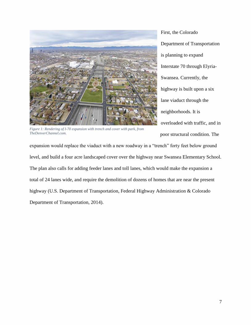
7
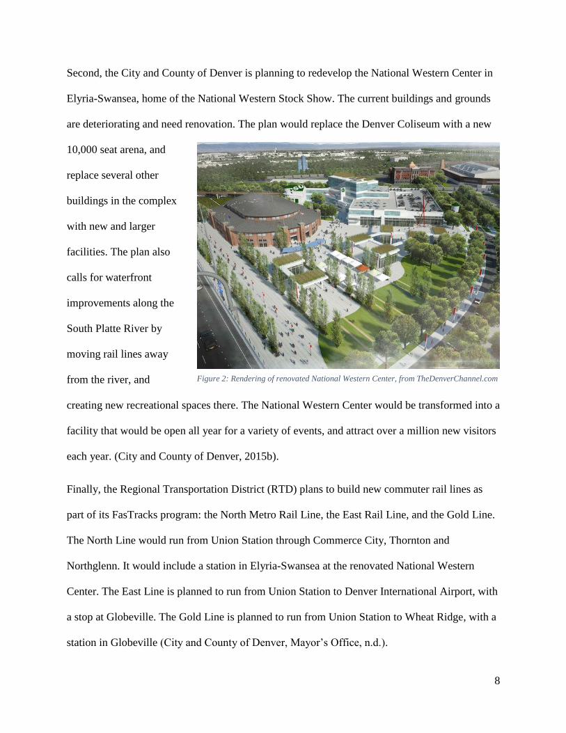
First, the Colorado
Department of Transportation
is planning to expand
Interstate 70 through Elyria-
Swansea. Currently, the
highway is built upon a six
lane viaduct through the
neighborhoods. It is
overloaded with traffic, and in
poor structural condition. The
expansion would replace the viaduct with a new roadway in a “trench” forty feet below ground
level, and build a four acre landscaped cover over the highway near Swansea Elementary School.
The plan also calls for adding feeder lanes and toll lanes, which would make the expansion a
total of 24 lanes wide, and require the demolition of dozens of homes that are near the present
highway (U.S. Department of Transportation, Federal Highway Administration & Colorado
Department of Transportation, 2014).
Figure 1: Rendering of I-70 expansion with trench and cover with park, from
TheDenverChannel.com.
8
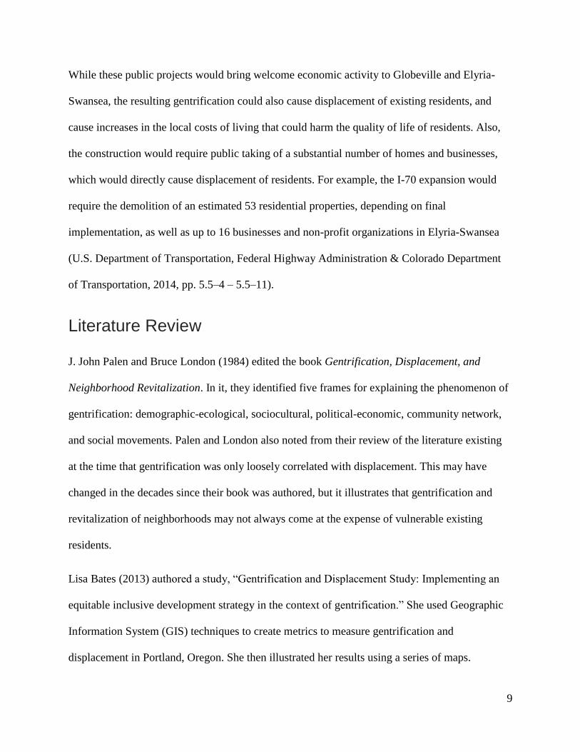
Second, the City and County of Denver is planning to redevelop the National Western Center in
Elyria-Swansea, home of the National Western Stock Show. The current buildings and grounds
are deteriorating and need renovation. The plan would replace the Denver Coliseum with a new
10,000 seat arena, and
replace several other
buildings in the complex
with new and larger
facilities. The plan also
calls for waterfront
improvements along the
South Platte River by
moving rail lines away
from the river, and
creating new recreational spaces there. The National Western Center would be transformed into a
facility that would be open all year for a variety of events, and attract over a million new visitors
each year. (City and County of Denver, 2015b).
Finally, the Regional Transportation District (RTD) plans to build new commuter rail lines as
part of its FasTracks program: the North Metro Rail Line, the East Rail Line, and the Gold Line.
The North Line would run from Union Station through Commerce City, Thornton and
Northglenn. It would include a station in Elyria-Swansea at the renovated National Western
Center. The East Line is planned to run from Union Station to Denver International Airport, with
a stop at Globeville. The Gold Line is planned to run from Union Station to Wheat Ridge, with a
station in Globeville (City and County of Denver, Mayor’s Office, n.d.).
Figure 2: Rendering of renovated National Western Center, from TheDenverChannel.com
9
While these public projects would bring welcome economic activity to Globeville and Elyria-
Swansea, the resulting gentrification could also cause displacement of existing residents, and
cause increases in the local costs of living that could harm the quality of life of residents. Also,
the construction would require public taking of a substantial number of homes and businesses,
which would directly cause displacement of residents. For example, the I-70 expansion would
require the demolition of an estimated 53 residential properties, depending on final
implementation, as well as up to 16 businesses and non-profit organizations in Elyria-Swansea
(U.S. Department of Transportation, Federal Highway Administration & Colorado Department
of Transportation, 2014, pp. 5.5–4 – 5.5–11).
Literature Review
J. John Palen and Bruce London (1984) edited the book Gentrification, Displacement, and
Neighborhood Revitalization. In it, they identified five frames for explaining the phenomenon of
gentrification: demographic-ecological, sociocultural, political-economic, community network,
and social movements. Palen and London also noted from their review of the literature existing
at the time that gentrification was only loosely correlated with displacement. This may have
changed in the decades since their book was authored, but it illustrates that gentrification and
revitalization of neighborhoods may not always come at the expense of vulnerable existing
residents.
Lisa Bates (2013) authored a study, “Gentrification and Displacement Study: Implementing an
equitable inclusive development strategy in the context of gentrification.” She used Geographic
Information System (GIS) techniques to create metrics to measure gentrification and
displacement in Portland, Oregon. She then illustrated her results using a series of maps.
10
Bates classified tracts in her study based on three measures: vulnerability, demographic change,
and housing market conditions. A tract was classified as having a more vulnerable population if
its population had higher than average numbers in the categories of renters, or racial or ethnic
minorities (Bates studied black or African-American individuals in her study, while in Denver,
Latinos in Globeville and Elyria-Swansea were the minority that appeared to be most
vulnerable.) Bates also classified tracts as having vulnerable populations when they had people
who do not have bachelor’s degrees, or households that had lower than 80% of HUD-adjusted
median income (Bates, 2013).
Bates classified tracts as having undergone gentrification-based demographic change if the share
of homeowners grew (relative to the percentage of homeowners in the city as a whole), the
population of white people increased, average education attainment increased, or average
household income increased.
Finally, Bates used housing valuation as a variable to form her gentrification metric. She
classified neighborhoods as being adjacent if the neighborhoods are next to areas that are
undergoing gentrification. She classified them as accelerating when home values were
appreciated rapidly, compared to city-wide rates between decennial census or ACS data sets. She
classified them as appreciated if they had high values in recent data sets, and lower values in
previous data sets, relative to Portland’s median appreciation rate.
Bates’s methodology created a final classification for Portland’s regions into six categories that
denote the region’s stage of gentrification: Susceptible, Early: Type 1, Early: Type 2, Dynamic,
Late, and Continued Loss. This study’s methodology is based strongly on Bates’s work, applying
it to Denver and its neighborhoods Globeville and Elyria-Swansea.
11
Bates based some of her work on a journal article by Lance Freeman (2005) in Urban Affairs
Review, titled “Displacement or Succession? Residential Mobility in Gentrifying
Neighborhoods.” Freeman was concerned with distinguishing the displacement of gentrification,
the forcing out of poor or struggling residents of a gentrifying neighborhood, from succession,
which is the normal turnover of housing as people move from home to home for mundane
reasons. He found that gentrification only had a modest correlation with displacement, and that
in many cases, changes in home ownership and residence were due to ordinary housing turnover.
Like Palen and London, Freeman observed that gentrification did not always come with
displacement for existing residents over the long term.
Freeman’s methodology used variables later used in Bates’s methodology, such as educational
attainment, percentages of minorities in population, median income, and housing values. His
choice of variables was intended to distinguish displacement due to gentrification from normal
housing turnover (Freeman, 2005).
Bates and Freeman’s methodologies attempted to measure displacement due to market forces
present during gentrification, which would include appreciating property values, landlords
evicting tenants or refusing to renew leases so they could sell their properties to developers, and
so on. Marianne Goodland (2015) wrote an article for the Colorado Independent describing
another form of displacement. Her article tells the story of Marta Gonzales. Gonzales, along with
all of the other residents of Denver’s Auraria neighborhood, were forced from their homes in
1974 when the City and County of Denver took them by eminent domain, to convert the
neighborhood into the Auraria Higher Education Center campus. Gonzales stated that Auraria
residents only received a fraction of the value of their homes in compensation, because the home
values plummeted after the city announced its plans to take them by eminent domain. Gonzales
12
and other “displaced Aurarians” are concerned that present-day plans to redevelop the National
Western Center and expand I-70 will displace current residents of Globeville and Elyria-
Swansea. Gonzales’s story is an example of public, rather than private displacement, where the
force of law, instead of market forces, causes vulnerable residents to be forced from their homes.
Marian Zuk, Ariel Bierbaum, Karen Chapple, Karolina Gorska, Anastasia Loukaitou-Sideris,
Paul Ong, and Trevor Thomas (2015) also researched the effects of public investment on
gentrification and displacement in their paper “Gentrification, Displacement, and the Role of
Public Investment: A Literature Review”. They found that although more research was required
on how much public investment played a role in gentrification, they did find that public
investment was linked with gentrification. Specifically, they found that investments in public
transit lines were associated with gentrification. They noted that affluent residents moving into
gentrifying neighborhoods were attracted to public transit infrastructure, such as light rail or
commuter rail lines, because they wanted to avoid difficult commutes that required driving on
congested roads.
While this study is focused on displacement due to gentrification, some of the literature
demonstrates some other negative consequences of gentrification, which this study and Bates’s
study do not measure. Whittle, Palar, Hufstedler, Seligman, Frongillo and Weiser (2015)
released a study titled “Food insecurity, chronic illness, and gentrification in the San Francisco
Bay Area: An example of structural violence in United States public policy”. This study
documents some of the negative effects other than displacement that gentrification may have on
a neighborhood’s residents. This study documents people living with HIV/AIDS, who have
endured food insecurity, because rising rents have left them without enough money to
consistently afford nutritious food when they had to subsist on disability benefits. Study
13
participants reported that they have endured periods of insufficient food, and periods of hunger.
They also reported concerns of negative health effects from a poor diet, exacerbated by
HIV/AIDS. Participants also reported being forced to steal food, exchange sex for food, sell
controlled substances, and depend on aid from friends, family, and charities.
Several groups have worked to alleviate the negative effects of gentrification, including
displacement. Maureen Kennedy and Paul Leonard (2001) wrote a white paper for PolicyLink
with several case studies, and provided a ten-step strategy that cities could use to manage
gentrification and mitigate its effects. Their goals are to promote equitable development. They
seek to replace displacing gentrification with equitable revitalization of neighborhoods and
communities. Their steps to improve the end results of gentrification can be summarized as
follows: understand the gentrification dynamics in the community, anticipate gentrification
pressures, organize stakeholders, develop a shared vision and implementation plan for growth
and revitalization, implementing policy and regulatory fixes, maximize public resources,
improve the public education system, prepare groups to negotiate, and create forums where
equitable negotiations can take place.
The National Trust for Historic Preservation has also worked on alleviating displacement due to
gentrification. Alexander Padro wrote in a pair of articles “Minimizing the Effects of
Gentrification” ((2015a) and (2015b)) for Main Street America about his efforts in Shaw Main
Streets to save resident and small businesses in Washington D.C. that were vulnerable to
displacement. Padro’s efforts resulted in several new buildings with affordable housing, resulting
in little or no displacement of residents. Additionally, over 170 small businesses have opened in
the Shaw neighborhood, providing jobs and economic growth for the neighborhood. Shaw Main
Street’s efforts have revitalized the neighborhood, without diminishing its character as a historic
14
African American community. Shaw Main Street was also able to save several historic small
businesses, including Wanda’s Hair Studio, from displacement by helping them move back into
retail space after renovation.
Purpose and Methodology
This study explores gentrification in Globeville and Elyria-Swansea, using data primarily from
the 2008-2012 American Community Survey (ACS), the 2000 and 1990 United States Census
data sets, and the U.S. Department of Housing and Urban Development’s Comprehensive
Housing Affordability Strategy (CHAS) data set, which in turn, is based on 2008-2012 ACS
data. The methodology is based on Lisa Bates’s study of gentrification in Portland, Oregon. This
methodology classifies regions (all the data required for the study was available at the census
tract level) into six categories that denote the region’s stage of gentrification: Susceptible, Early:
Type 1, Early: Type 2, Dynamic, Late, and Continued Loss.
Because several new public projects are in the planning stages, including the I-70 expansion, the
renovation of the National Western Center, and the construction of the RTD FasTracks rail lines,
a new wave of investment and redevelopment could come to the neighborhoods of Globeville
and Elyria-Swansea. While economic revitalization is welcome, there are concerns as to whether
this revitalization could manifest as gentrification that causes displacement of the
neighborhoods’ current residents, and harms other residents’ quality of life.
Using Bates’s methodology, the author examined Globeville and Elyria-Swansea, to determine
which of six categories describe their state of gentrification. The methodology uses three types of
measurements to classify tracts: vulnerability to displacement, demographic changes, and
housing market appreciation (Bates, 2013).
15
Vulnerability
A tract is assigned a vulnerability score from zero to four, with one added to the score under the
following conditions.
The number of households that are renters is greater than the city-wide average, minus
the margin of error (MOE). For Denver, the threshold is 50.24%.
The percentage of the population that is Latino is greater than the city-wide average,
minus the MOE. In Denver, the threshold is 31.77%.
The percentage of the population that has not achieved a bachelor’s degree or higher is
greater than the city-wide average, minus the MOE. The threshold for Denver is 61.06%.
The percentage of households with income less than 80% of the HUD-adjusted median
family income is greater than the city-wide average, minus the MOE. The threshold for
Denver is 49.33%.
A tract is classified as vulnerable if it has a vulnerability score of three or four.
Demographic Changes
A tract is classified as having experienced demographic change related to gentrification and
displacement if three of the following four conditions are true.
The share of homeowners has increased more (or decreased less) than the city-wide rate
of increase in home-ownership, minus the MOE. In Denver, this threshold is -2.961%
(Denver’s city-wide home ownership rate fell between 2000 and 2012.)
The population of white people has increased more than the city-wide rate of change,
minus the MOE. Denver’s threshold number is 0.253%.
16
The share of the population with a bachelor’s degree or better has increased more than
the city-wide rate of change, minus the MOE. The Denver threshold was 6.144%.
Median household income has increased more (or decreased less) than the city-wide
average rate of change. Denver’s threshold was -$6,119. (Denver’s median household
income, adjusted to 2012 dollars, fell from 2000 to 2012.)
A tract will also be classified as having experienced demographic change if two of the above
conditions were met, if the two conditions were:
The population of white people has increased more than the city-wide rate of change,
minus the MOE.
The share of the population with a bachelor’s degree or better has increased more than
the city-wide rate of change, minus the MOE.
Housing Market Conditions
A tract’s home value ratio is defined as the ratio of the tract’s median home value to Denver’s
city-wide median home value. It will be classified as low or moderate if it is in the bottom three
quintiles of home value ratios, and classified as high if in the top two quintiles.
Appreciation rates will be classified as low or moderate if they are in the bottom three quintiles,
and classified as high if they are in the top two quintiles.
A tract will be classified as adjacent if:
It has a low or moderate 2012 value ratio.
It has a low or moderate appreciation rate.
17
It touches the boundary of at least one tract with high 2012 value ratio and/or a high
2000-2012 appreciation rate.
A tract will be classified as accelerating if:
It had a low or moderate 2012 value.
It has a high 2000-2012 appreciation rate.
A tract will be classified as appreciated if:
It has a low or moderate 1990 value ratio.
It has a high 2012 value ratio.
It has a high 1990-2012 appreciation rate.
Tract Classification
Based on the vulnerability, demographic change, and housing market condition classifications,
the tracts of Globeville and Elyria-Swansea were classified into one of the following categories
based on the data.
Susceptible tracts are tracts that are adjacent to high-value or high-appreciation tracts,
but still have low or moderate home values and appreciation rates.
Early: Type 1 tracts have high appreciation rates over the past decade, but still have low
or moderate home values. Population in these tracts are classified as vulnerable, but no
gentrification-related demographic changes have occurred yet.
Early: Type 2 tracts are adjacent to high-value or high-appreciation tracts, but still have
low or moderate home values and appreciation rates. They have populations classified as
vulnerable, and have experienced demographic change indicative of gentrification.

18
Dynamic tracts have high appreciation rates over the last decade, but still have low or
moderate home values (they are classified as accelerating). Demographic changes
indicative of displacement have taken place, but the tract still has a vulnerable
population.
Late tracts have had low or moderate home values in 1990, but experienced high
appreciation rates over the last two decades, and now have high property values. They
have experienced gentrification-related demographic change, but still have a vulnerable
population.
Continued Loss tracts have had low or moderate home values in 1990, but had high
appreciation rates over the last two decades, and now have high property values. They no
longer have above-average levels of vulnerable populations, and have experienced high
levels of demographic changes over the previous two decades. Remaining vulnerable
households may be at risk of displacement.
19
Results
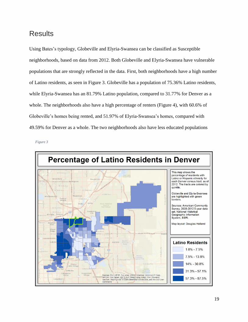
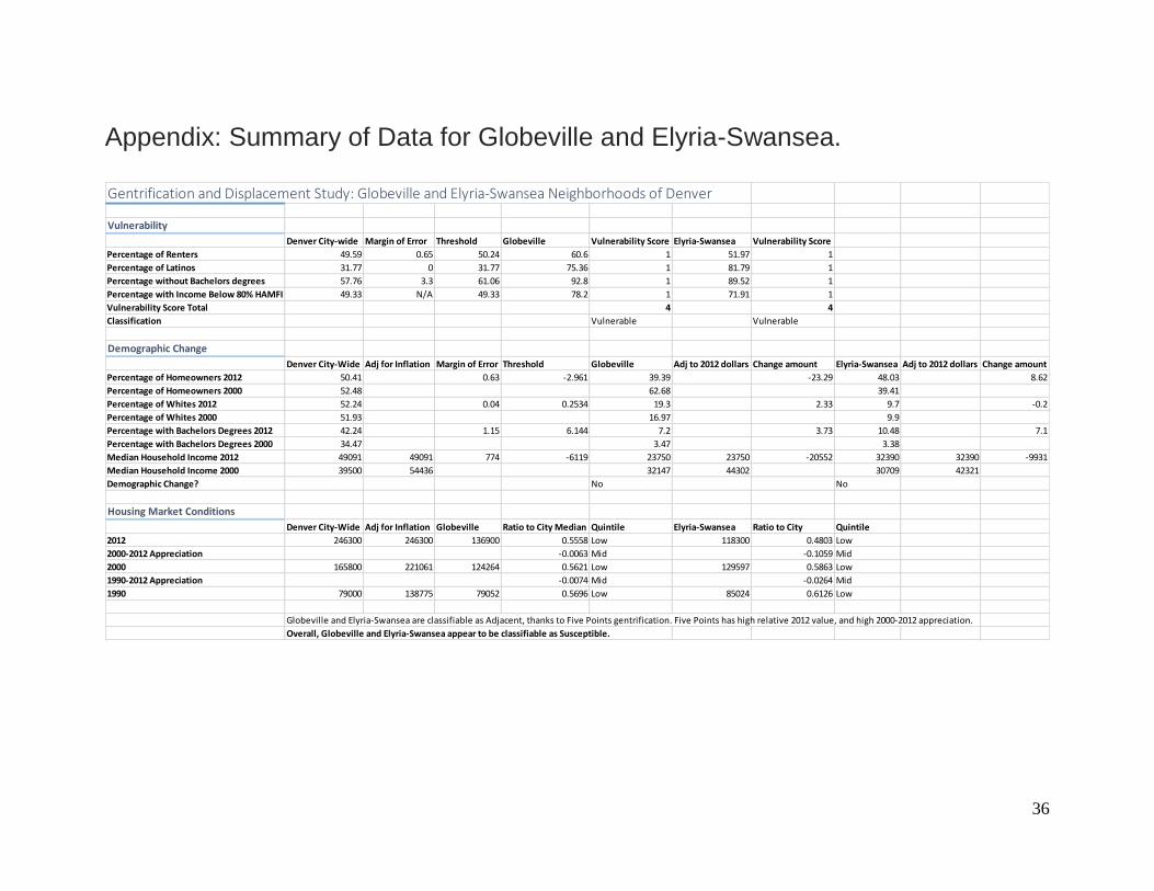
Using Bates’s typology, Globeville and Elyria-Swansea can be classified as Susceptible
neighborhoods, based on data from 2012. Both Globeville and Elyria-Swansea have vulnerable
populations that are strongly reflected in the data. First, both neighborhoods have a high number
of Latino residents, as seen in Figure 3. Globeville has a population of 75.36% Latino residents,
while Elyria-Swansea has an 81.79% Latino population, compared to 31.77% for Denver as a
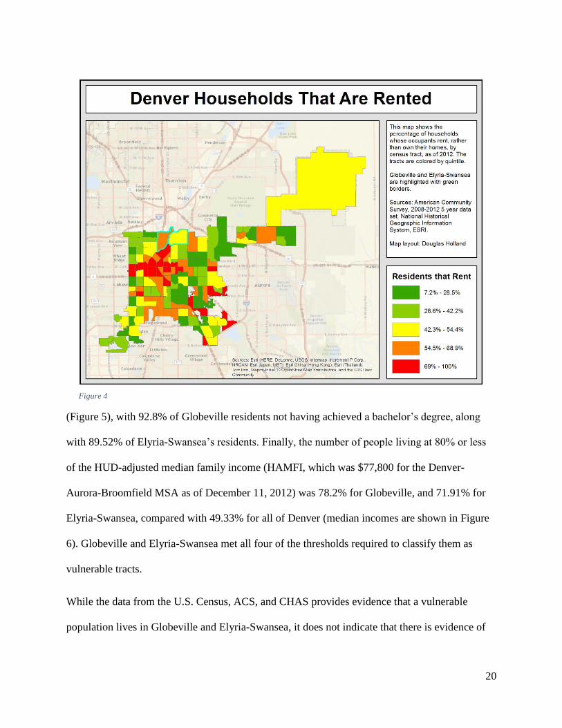
whole. The neighborhoods also have a high percentage of renters (Figure 4), with 60.6% of
Globeville’s homes being rented, and 51.97% of Elyria-Swansea’s homes, compared with
49.59% for Denver as a whole. The two neighborhoods also have less educated populations
Figure 3
20
(Figure 5), with 92.8% of Globeville residents not having achieved a bachelor’s degree, along
with 89.52% of Elyria-Swansea’s residents. Finally, the number of people living at 80% or less
of the HUD-adjusted median family income (HAMFI, which was $77,800 for the Denver-
Aurora-Broomfield MSA as of December 11, 2012) was 78.2% for Globeville, and 71.91% for
Elyria-Swansea, compared with 49.33% for all of Denver (median incomes are shown in Figure
6). Globeville and Elyria-Swansea met all four of the thresholds required to classify them as
vulnerable tracts.
While the data from the U.S. Census, ACS, and CHAS provides evidence that a vulnerable
population lives in Globeville and Elyria-Swansea, it does not indicate that there is evidence of
Figure 4
21
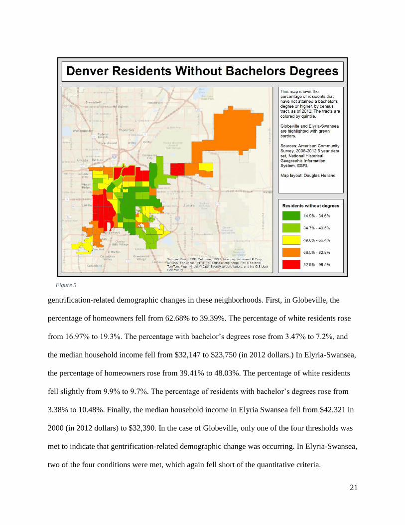
gentrification-related demographic changes in these neighborhoods. First, in Globeville, the
percentage of homeowners fell from 62.68% to 39.39%. The percentage of white residents rose
from 16.97% to 19.3%. The percentage with bachelor’s degrees rose from 3.47% to 7.2%, and
the median household income fell from $32,147 to $23,750 (in 2012 dollars.) In Elyria-Swansea,
the percentage of homeowners rose from 39.41% to 48.03%. The percentage of white residents
fell slightly from 9.9% to 9.7%. The percentage of residents with bachelor’s degrees rose from
3.38% to 10.48%. Finally, the median household income in Elyria Swansea fell from $42,321 in
2000 (in 2012 dollars) to $32,390. In the case of Globeville, only one of the four thresholds was
met to indicate that gentrification-related demographic change was occurring. In Elyria-Swansea,
two of the four conditions were met, which again fell short of the quantitative criteria.
Figure 5
22
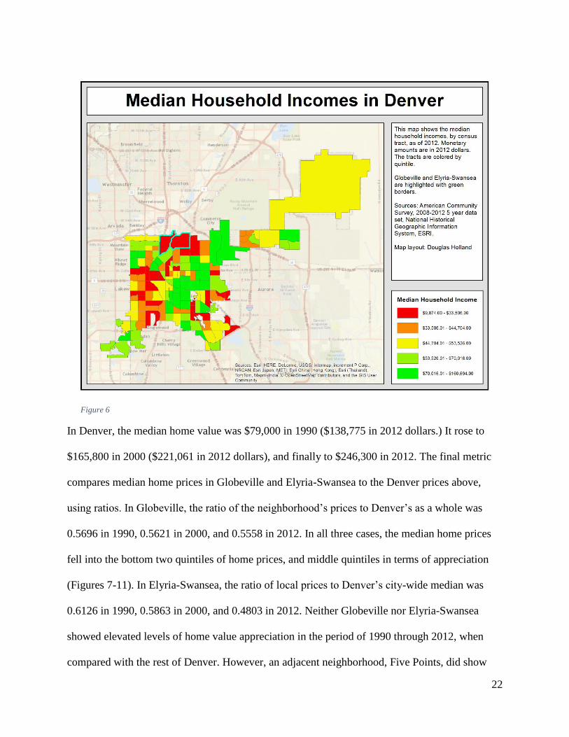
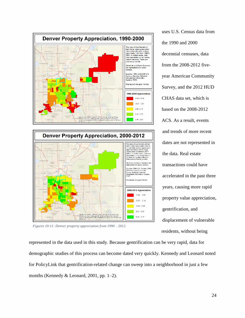
In Denver, the median home value was $79,000 in 1990 ($138,775 in 2012 dollars.) It rose to
$165,800 in 2000 ($221,061 in 2012 dollars), and finally to $246,300 in 2012. The final metric
compares median home prices in Globeville and Elyria-Swansea to the Denver prices above,
using ratios. In Globeville, the ratio of the neighborhood’s prices to Denver’s as a whole was
0.5696 in 1990, 0.5621 in 2000, and 0.5558 in 2012. In all three cases, the median home prices
fell into the bottom two quintiles of home prices, and middle quintiles in terms of appreciation
(Figures 7-11). In Elyria-Swansea, the ratio of local prices to Denver’s city-wide median was
0.6126 in 1990, 0.5863 in 2000, and 0.4803 in 2012. Neither Globeville nor Elyria-Swansea
showed elevated levels of home value appreciation in the period of 1990 through 2012, when
compared with the rest of Denver. However, an adjacent neighborhood, Five Points, did show
Figure 6
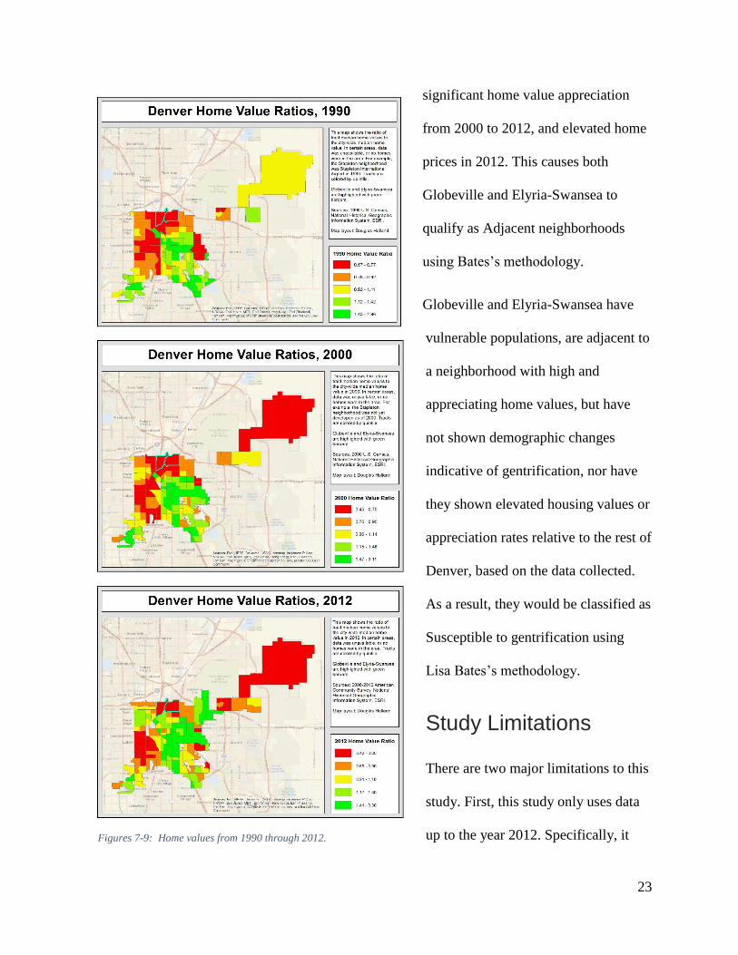
23
significant home value appreciation
from 2000 to 2012, and elevated home
prices in 2012. This causes both
Globeville and Elyria-Swansea to
qualify as Adjacent neighborhoods
using Bates’s methodology.
Globeville and Elyria-Swansea have
vulnerable populations, are adjacent to
a neighborhood with high and
appreciating home values, but have
not shown demographic changes
indicative of gentrification, nor have
they shown elevated housing values or
appreciation rates relative to the rest of
Denver, based on the data collected.
As a result, they would be classified as
Susceptible to gentrification using
Lisa Bates’s methodology.
Study Limitations
There are two major limitations to this
study. First, this study only uses data
up to the year 2012. Specifically, it Figures 7-9: Home values from 1990 through 2012.
24
uses U.S. Census data from
the 1990 and 2000
decennial censuses, data
from the 2008-2012 five-
year American Community
Survey, and the 2012 HUD
CHAS data set, which is
based on the 2008-2012
ACS. As a result, events
and trends of more recent
dates are not represented in
the data. Real estate
transactions could have
accelerated in the past three
years, causing more rapid
property value appreciation,
gentrification, and
displacement of vulnerable
residents, without being
represented in the data used in this study. Because gentrification can be very rapid, data for
demographic studies of this process can become dated very quickly. Kennedy and Leonard noted
for PolicyLink that gentrification-related change can sweep into a neighborhood in just a few
months (Kennedy & Leonard, 2001, pp. 1–2).
Figures 10-11: Denver property appreciation from 1990 – 2012.
25
Furthermore, the study relies exclusively on demographic and property value data, but this kind
of statistical analysis cannot take into account recent events, such as the planning of the I-70
expansion, the renovation and redevelopment of the National Western Complex, and the
development of the RTD FasTracks North Line. In particular, the I-70 expansion will have a
disproportionate effect on residents of Globeville and Elyria-Swansea, because the plans call for
the appropriation and razing of dozens of homes, along with over a dozen small businesses and
non-profits. This action alone creates involuntary displacement that will significantly affect
Elyria-Swansea.
Another limitation is that using the Bates methodology limits the study to using data at the
census tract level. By changing the data sets, specifically, switching the metric of number of
households below HAMFI, to a different metric which may be found in the ACS five-year data
set, it is possible to make an analysis using census block groups instead of census tracts, which
would result in finer granularity. Such a methodology change may make it possible to observe
whether certain parts of Globeville and Elyria-Swansea are more vulnerable to gentrification, or
further advanced in the process, than others.
Finally, the Bates methodology doesn’t make use of some data that is available in the City of
Denver, including a parcels data set that includes assessment and transaction data for properties
in Denver. This data set could have provided valuable current data to find patterns of unusually
high property values or appreciation rates that could serve as evidence of gentrification. Such
data sets could also be analyzed, to find patterns of speculative real-estate transactions, or to find
evidence of higher levels of relocations of vulnerable classes of residents (City and County of
Denver, 2015c).
26
Extrapolations
Recent events indicate that Globeville and Elyria-Swansea are much further into the process of
gentrification than the results of using Bates’s methodology indicate. Quantitative studies using
demographics and housing values can only provide part of the knowledge required to understand
the dynamics of gentrification in Globeville and Elyria-Swansea. The upcoming public projects,
for example, can drive significant changes in the housing markets in these neighborhoods, by
creating increased demand for real-estate and housing.
There are two types of displacement that may happen during the gentrification process. One is
displacement through economic forces. In this process, existing disadvantaged residents are
economically overpowered by incoming developers and investors. Landlords sell their properties
or raise rents, forcing disadvantaged renters out. Homeowners, including senior citizens on fixed
incomes, get pushed out due to escalating property taxes from higher property valuations. Small
businesses may find that the changing economic conditions caused by gentrification make them
unable to make a profit. For those who are not displaced, escalating costs of living, and other
expenses diminish quality of life.
The second type of displacement is due to public projects. These investments also displace
residents and businesses, sometimes with economic pressure in the same way as private
economic displacement, but also sometimes with the force of law, using takings through eminent
domain. In the case of Auraria, a new campus for higher learning was constructed after forcing
all of the residents of Auraria out of their homes. Expansion or reconstruction of facilities, such
as the National Western Center could also cause displacement. In some cases, property owners in
the way of projects voluntarily sell their properties, and can use the funds to relocate. Renters are
27
often forced out when property owners decide to sell. In many cases, the news of a public taking
can force property values down, diminishing the compensation property owners receive. This
happened to Marta Gonzales when she was forced from Auraria. While the U.S. Constitution
requires that property owners be compensated for takings, in many cases, the compensation may
not be equivalent to fair market value in the project’s absence (Goodland, 2015).
The political and legal force of public project displacement can be strongly connected with the
economic force of private displacement. Whether residents are evicted by a landlord that has
agreed to sell to developers, or by an order of eminent domain so their homes can be bulldozed
for a new highway, the residents are displaced either way.
Also, economic displacement and public displacement may exacerbate each other. The
expansion of I-70, National Western Center redevelopment, and FasTracks line construction may
also significantly stimulate real-estate speculation, resulting in outbidding of current residents.
At the same time, new economic activity in the area, or speculated activity in the area can drive
demand for new public projects that may result in eminent-domain takings of homes.
Recommendations for Future Study
Based on this study, there are several possible directions for future study of gentrification in
Denver. I have four recommendations for future research into gentrification in Globeville,
Elyria-Swansea, and the rest of Denver:
1. Collect demographic data in Globeville and Elyria-Swansea, and monitor for
demographic changes indicative of gentrification.
2. Study gentrification with other data sets currently available in the City and County of
Denver.
28
3. Change methodology to exclude data sets that are only available at the census tract level,
to enable analysis at the census block group level.
4. Study the effects of public investments on gentrification.
First, the City and County of Denver needs to continuously monitor demographics and property
values in order to be able to track the progression of gentrification or revitalization in Globeville
and Elyria-Swansea. As noted above, the data from the American Community Survey, and the
U.S. Census are not recent enough to provide current information on gentrification or
displacement in these neighborhoods. Any studies intended to measure displacement in
Globeville and Elyria-Swansea need more current data, which could be collected with periodic
surveys. Specifically, data collected could include percentages of Latino residents, educational
attainment, and household incomes, because significant changes in these demographics may
indicate that gentrification-caused displacement is taking place. The percentage of renters vs.
homeowners may also be a factor that can show the effects of displacement, though
distinguishing gentrification displacement from normal turnover that has also shown changes
from home-owning to renting is more difficult. Studying senior citizens and disabled residents
may also be useful, because these residents may have fixed incomes that would make them
particularly vulnerable to displacement. Policy changes intended to address gentrification would
be far more effective if they were developed and targeted using recent data.
Second, future studies should make use of data sources available in Denver. Denver’s parcel
records would be a valuable resource for gentrification studies. It includes data on assessment
valuations, transactions, and information on individuals and entities buying and selling real estate
in Denver. This particular data set could provide granularity all the way down to the parcel level.
It could be analyzed for patterns of speculative buying, or for patterns of unusually high property
29
prices or appreciation rates. Analysis could also be made on whether properties are being
purchased or sold by individuals, or by corporations who may be engaged in gentrification-
related transactions.
Third, future studies should diverge from the Bates methodology, in order to use data that is
available at a higher granularity level. Because the Bates methodology used the HUD CHAS
data set, which was available only down to the census tract level, this study was limited in its
results to the census tract level. A future study, that perhaps substituted median income data from
the American Community Survey, would make it possible to perform a gentrification analysis at
the level of census block groups, which would make it possible to determine if particular parts of
a neighborhood were at a different stage of gentrification, or were at more risk of gentrifying or
displacing underprivileged residents.
Finally, the City and County of Denver should study the effects of public investments on
gentrification and displacement. Globeville and Elyria-Swansea are currently targeted with
significant public investment in the form of the I-70 expansion, the National Western Center
renovation, and RTD improvements. The city should examine how other public investments,
such as the renovation and expansion of Union Station, or the recent expansion of RTD’s light-
rail network affect surrounding properties. The city may need policies to improve availability of
affordable housing that is close to public transit infrastructure such as light rail. Clearer
understanding of the dynamics of public investment and gentrification could help the city
manage its growth so that it is beneficial, rather than displacing, to residents.
30
Conclusions
Proper management of neighborhood revitalization, through collaborative public processes can
protect vulnerable populations of residents from being forced from their homes by market forces,
or by public investments. Without proper management, gentrification may cause residents to not
only be displaced, but also experience hardships due to rising costs of living, or from being
forced into areas with poor services, high crime, and concentrated poverty. The combination of
the expansion of I-70, the renovation of the National Western Center, and RTD’s FasTracks
construction present significant challenges to the city of Denver because these kinds of public
investments may drive gentrification.
Some general policy could be implemented to facilitate the process of mitigating displacement of
vulnerable residents:
1. Strengthen stakeholder forums.
2. Strengthen the shared vision for the future of Globeville and Elyria-Swansea.
3. Maximize the use of available assets, by encouraging infill and brownfield development,
as an alternative to displacing development.
First, the forums that stakeholders are using to discuss this issue could be strengthened, so all
parties, including residents, can make their concerns heard and come to equitable solutions.
Kennedy and Leonard emphasized the importance of public forums, and an equitable negotiation
process, with all parties aware of their options and legal rights. This means that residents,
property owners, businesses, non-profit organizations, developers, the City and County of
Denver, the Colorado Department of Transportation, RTD, and other stakeholders need to be
31
working together to address gentrification and displacement (Kennedy & Leonard, 2001, pp. 38–
39).
Second, Globeville and Elyria-Swansea could use a stronger, shared, coherent vision for
community development. The City and County of Denver ((2014) and (2015a)) have master
plans for these neighborhoods, which are a good start. The plans promise improvements, such as
construction of infrastructure, a commitment to maintaining access to affordable housing,
making the neighborhoods more interconnected and livable, management of long-standing issues
such as neglected properties, badly connected neighborhoods, pollution, and lack of access to
amenities like a full-service grocery store. Plans like this are a beginning, but the process of
planning and managing growth in these neighborhoods is continuous. The City and County of
Denver needs to continuously engage with community members and stakeholders to ensure that
a strong vision for positive revitalization of these neighborhoods is fulfilled, rather than
neglected.
Finally, Kennedy and Leonard suggest maximizing the use of available public assets for the
public good. In Globeville and Elyria-Swansea, for example, the City of Denver’s neighborhood
plans call for decontaminating and reusing brownfield sites, and encouraging infill development.
This can provide an important alternative to gentrifying development that results in
displacement. Brownfield reuse has disadvantages, including the expense of cleaning up
environmental hazards, and the potential for environmental justice problems (City and County of
Denver, 2014) (City and County of Denver, 2015a).
Using the methodology Bates used in Portland, the populations of Globeville and Elyria Swansea
are classified as susceptible to displacement caused by gentrification. However, the data is not
recent enough to show the consequences of new events, so more research is required. In fact,
32
recent developments suggest that while the data does not show that Globeville and Elyria-
Swansea have undergone gentrification, that in reality, gentrification may already be taking
place.
This study shows the importance of timing in gentrification issues. The City and County of
Denver may have little time to collect data and implement policies if they wish to mitigate
displacement and other negative effects of gentrification in Globeville and Elyria-Swansea. The
city should focus on collecting more current data for future studies. In addition, they can use data
like Denver’s parcels dataset, modify methodologies to perform analyses at a block-group level,
and perform studies focused on gentrification near new public infrastructure investments,
especially public transit construction. These avenues of research can enable the City and County
of Denver to understand the dynamics of gentrification in Globeville, Elyria-Swansea, and the
rest of Denver.
33
References
Armijo, G., & Hook, G. C. (2014, September). How Neighborhood Planning Affects Health in
Globeville and Elyria Swansea. Denver Department of Environmental Health. Retrieved
from
https://denvergov.org/Portals/746/documents/HIA/HIA%20Composite%20Report_9-18-
14.pdf
Bates, L. K. (2013, May 18). Gentrification and Displacement Study: implementing an equitable
inclusive development strategy in the context of gentrification. City of Portland Bureau
of Planning and Sustainability. Retrieved from
http://www.portlandoregon.gov/bps/article/454027
City and County of Denver. (2014, December 1). Globeville Neighborhood Plan. Retrieved from
https://www.denvergov.org/content/dam/denvergov/Portals/646/documents/planning/Plan
s/globeville/GlobevillePlanFinal.pdf
City and County of Denver. (2015a, February 23). 2015 Elyria and Swansea Neighborhoods
Plan. Retrieved from
https://www.denvergov.org/content/dam/denvergov/Portals/646/documents/planning/Plan
s/elyria_swansea/Elyria_Swansea_Neighborhood_Final_Web_sm.pdf
City and County of Denver. (2015b, March 9). National Western Center Master Plan. City and
County of Denver. Retrieved from
https://www.denvergov.org/content/dam/denvergov/Portals/728/documents/NDCC/NWC
_MPdoc_FINAL_web%203.3.15.pdf
City and County of Denver. (2015c, December 5). Parcels. Retrieved December 7, 2015, from
34
City and County of Denver, Mayor’s Office. (n.d.). RTD Station Development. Retrieved
November 19, 2015, from https://www.denvergov.org/content/denvergov/en/mayors-
office/programs-initiatives/north-denver-cornerstone-collaborative/rtd-station-
development.html
Freeman, L. (2005). Displacement or Succession? Residential Mobility in Gentrifying
Neighborhoods. Urban Affairs Review, 40(4), 463–491.
http://doi.org/10.1177/1078087404273341
Goodland, M. (2015, November 4). The parable of gentrification. Retrieved November 17, 2015,
from http://www.coloradoindependent.com/156024/denver-victims-of-gentrification-fret-
for-elyria-swansea-and-globeville-residents
Kennedy, M., & Leonard, P. (2001, April). Dealing with Neighborhood Change: A Primer on
Gentrification and Policy Choices. PolicyLink and The Brookings Institution Center on
Urban and Metropolitan Policy. Retrieved from
http://www.policylink.org/sites/default/files/DealingWithGentrification_final.pdf
Minnesota Population Center. (2011). National Historical Geographic Information System,
version 2.0, using data from U.S. Census and American Community Survey. Minneapolis,
MN: University of Minnesota. Retrieved from http://www.nhgis.org/
Padro, A. M. (2015a, June 25). Minimizing the Effects of Gentrification: Part I. Retrieved
November 16, 2015, from http://www.preservationnation.org/main-street/main-street-
news/story-of-the-week/2015/minimizing-the-effects-
of.html?utm_source=facebook&utm_medium=like&utm_campaign=Minimizing the
Effects of Gentrification: Part I
35
Padro, A. M. (2015b, July 10). Minimizing the Effects of Gentrification: Part II. Retrieved
November 16, 2015, from http://www.preservationnation.org/main-street/main-street-
news/story-of-the-week/2015/minimizing-the-effects-of-
1.html?utm_source=facebook&utm_medium=like&utm_campaign=Minimizing the
Effects of Gentrification: Part II
Palen, J. J., & London, B. (Eds.). (1984). Gentrification, displacement, and neighborhood
revitalization. Albany: State University of New York Press.
U.S. Department of Housing and Urban Development. (2012). Comprehensive Housing
Affordability Strategy (CHAS) 2008-2012 Data Set. Retrieved November 10, 2015, from
http://www.huduser.gov/portal/datasets/cp.html
U.S. Department of Transportation, Federal Highway Administration, & Colorado Department of
Transportation. (2014, August 4). I-70 East Supplemental Draft Environmental Impact
Statement and Section 4(f) Evaluation. Retrieved from http://www.i-
70east.com/reports.html
Whittle, H. J., Palar, K., Hufstedler, L. L., Seligman, H. K., Frongillo, E. A., & Weiser, S. D.
(2015). Food insecurity, chronic illness, and gentrification in the San Francisco Bay
Area: An example of structural violence in United States public policy. Social Science &
Medicine, 143, 154–161. http://doi.org/10.1016/j.socscimed.2015.08.027
Zuk, M., Bierbaum, A. H., Chapple, K., Gorska, K., Loukaitou-Sideris, A., Ong, P., & Thomas,
T. (2015, August). Gentrification, Displacement, and the Role of Public Investment: A
Literature Review. Federal Reserve Bank of San Francisco. Retrieved from
http://www.frbsf.org/community-development/files/wp2015-05.pdf
36
Appendix: Summary of Data for Globeville and Elyria-Swansea.
Gentrification and Displacement Study: Globeville and Elyria-Swansea Neighborhoods of Denver
Vulnerability
Denver City-wide Margin of Error Threshold Globeville Vulnerability Score Elyria-Swansea Vulnerability Score
Percentage of Renters 49.59 0.65 50.24 60.6 1 51.97 1
Percentage of Latinos 31.77 0 31.77 75.36 1 81.79 1
Percentage without Bachelors degrees 57.76 3.3 61.06 92.8 1 89.52 1
Percentage with Income Below 80% HAMFI 49.33 N/A 49.33 78.2 1 71.91 1
Vulnerability Score Total 4 4
Classification Vulnerable Vulnerable
Demographic Change
Denver City-Wide Adj for Inflation Margin of Error Threshold Globeville Adj to 2012 dollars Change amount Elyria-Swansea Adj to 2012 dollars Change amount
Percentage of Homeowners 2012 50.41 0.63 -2.961 39.39 -23.29 48.03 8.62
Percentage of Homeowners 2000 52.48 62.68 39.41
Percentage of Whites 2012 52.24 0.04 0.2534 19.3 2.33 9.7 -0.2
Percentage of Whites 2000 51.93 16.97 9.9
Percentage with Bachelors Degrees 2012 42.24 1.15 6.144 7.2 3.73 10.48 7.1
Percentage with Bachelors Degrees 2000 34.47 3.47 3.38
Median Household Income 2012 49091 49091 774 -6119 23750 23750 -20552 32390 32390 -9931
Median Household Income 2000 39500 54436 32147 44302 30709 42321
Demographic Change? No No
Housing Market Conditions
Denver City-Wide Adj for Inflation Globeville Ratio to City Median Quintile Elyria-Swansea Ratio to City Quintile
2012 246300 246300 136900 0.5558 Low 118300 0.4803 Low
2000-2012 Appreciation -0.0063 Mid -0.1059 Mid
2000 165800 221061 124264 0.5621 Low 129597 0.5863 Low
1990-2012 Appreciation -0.0074 Mid -0.0264 Mid
1990 79000 138775 79052 0.5696 Low 85024 0.6126 Low
Globeville and Elyria-Swansea are classifiable as Adjacent, thanks to Five Points gentrification. Five Points has high relative 2012 value, and high 2000-2012 appreciation.
Overall, Globeville and Elyria-Swansea appear to be classifiable as Susceptible.


