39
A STUDY ON EARTH OBSERVATION TRAINING DATA LANDSCAPE IN INDIA

A STUDY ON EARTH OBSERVATION
TRAINING DATA LANDSCAPE IN INDIA

Published by:
Deutsche Gesellschaft fürInternationale Zusammenarbeit (GIZ) GmbH
Registered offices:
Bonn and Eschborn
A Study on Earth Observation Training Data Landscape in India
A2/18, Safdarjung EnclaveT: +91 11 4949 5353F: +91 4949 539E: [email protected]: www.giz.de/india
Person Responsible:
Mr Gaurav SharmaE: [email protected] Forward – Artificial Intelligence for All
Author:
Dr. Sudhira H. S., Gubbi Labs LLPwww.gubbilabs.in
Editor:
Ms Susheela Srinivas, Gubbi Labs LLP
Design and Layout:
Ms Savitha Sekhar Nair, Gubbi Labs LLP
Photo Credits:
All images used in the report are openly accessible and made to use for reusability and modification. Some images are sourced from NASA and are as per their Image Usage Policy.
On behalf of theGerman Federal Ministry for Economic Cooperation and Development (BMZ)
GIZ is responsible for the content of this publicationNew Delhi, IndiaSeptember 2021
Disclaimer:
The data in the publication has been collected, analysed and compiled with due care; and has been prepared in good faith based on information available at the date of publication without any independent verification. However, Deutsche Gesellschaft für Internationale Zusammenarbeit (GIZ) GmbH does not guarantee the accuracy, reliability, completeness or currency of the information in this publication. GIZ shall not be held liable for any loss, damage, cost or expense incurred or arising by reason of any person using or relying on information in this publication. GIZ makes no claims concerning the validity, accuracy or completeness of the maps nor assumes any liability resulting from the use of the information therein. The geographical map used is for informational purposes only and does not constitute recognition of boundaries or regions.

A STUDY ON EARTH OBSERVATION TRAINING DATA LANDSCAPE IN INDIA
CONTENTSPREFACE
EXECUTIVE SUMMARY
1. EARTH OBSERVATION IN INDIA 1
1.1. Geoportals And State Gis Initiatives 41.2. EO Studies In India
2. RESEARCH STUDY 4
2.1. Objectives 72.2. Method 7
3. EO TRAINING DATA LANDSCAPE 8
4. FINDINGS 10
4.1. Data Sources 114.2. Willingness To Share Training Data 114.3. Existing Training Datasets In India 124.3.1. Derivable Training Data 13
4.4. What Does It Take To Have A Data Sharing Ecosystem? 184.5. Summary And Limitations 18
5. CHALLENGES AND RECOMMENDATIONS 19
5.1. Challenges 195.1.1. Portal For Data Sharing 19
5.1.2. Ensuring Data Quality 19
5.2. Recommendations 205.2.1. Capacity Building 20
5.2.2. Incentivising For Sharing Training Data 20
5.2.3. Leveraging Citizen Science 21
5.2.4. Drive through NDSAP and other Missions Under Pm-Stiac 21
5.3. Summary 21
REFERENCES 22
ANNEXURES 26
Annexure 1: Draft of National Geospatial Policy and Guidelines 26Annexure 2: National Data Sharing and Accessibility Policy (NDSAP) 26

Annexure 3: Open Government Data (OGD) License 26Annexure 4: SpaceRS Policy-2020 and SpaceRS NGP-2020 26Annexure 5: Study Method and Questionnaire 27Annexure 6: List of Experts who Participated in Qualitative Discussions 30Annexure 7: Tools and Libraries for Sharing EO Training Dataset 31

A STUDY ON EARTH OBSERVATION TRAINING DATA LANDSCAPE IN INDIA
Preface
On behalf of the German Federal Ministry for Economic Cooperation and Development (BMZ), the Deutsche Gesellschaft für Internationale Zusammenarbeit (GIZ) GmbH is implementing the project “FAIR Forward – Artificial Intelligence for All”. The project strives for a more open, inclusive, and sustainable approach to Artificial Intelligence (AI) on the international level.
The growing number of geospatial platform providers has led to a sharp increase in the supply of Earth observation (EO) data – especially satellite imagery. For example, the satellite data from NASA’s Landsat mission, the Sentinel satellites of the European Union (EU) or the available imagery from Indian satellites offer free and open data and services. The growing availability of EO data meets an expanding interest and potential real-world impact that Artificial Intelligence (AI) and Machine Learning (ML) offer. FAIR Forward is committed to improving the conditions for Indian developers and EO experts to use geospatial data and ML to promote sustainable development.
ML and EO are two complementary areas that can provide faster solutions to more complex problems: for example, calculating the expected yield of crops in a particular area, detecting pests on agricultural fields, monitoring deforestation, or predicting the likelihood and extent of a global disease outbreak. Therefore, open EO training data and models have great potential to make EO technology more inclusive and enable millions of people to access services they cannot use yet – be it in agriculture, education, health, or any other field.
However, often technical practitioners lack access to high-quality geo- and ground-referenced data to develop and train ML models. Existing EO training datasets do not sufficiently represent the Indian context but are skewed towards North America and Europe. The resulting models do not transfer accurately to different regions and produce biased or wrong results. Hence, the innovative potential of this technology is largely untapped. Open training datasets provide local innovators with the opportunity to test new applications and products by reducing the cost of developing a prototype. This minimises the main barriers to AI utilising EO technologies and creates a potential market for tech innovators and social entrepreneurs. Also, it enables the public, private and voluntary sectors to access the latest AI technology more freely.
With this in mind, one of the primary goals of the FAIR Forward: AI for All project is to provide open, non-discriminatory, inclusive training data and open-source AI applications for local innovation. This objective rolls into developing sustainable and scalable modes of data collection that produce easily accessible and locally relevant EO training datasets and models for Indian users in a consistent, unbiased, privacy-sensitive, and cost-efficient way. To do so, an evaluation of existing efforts to create EO datasets in India is needed, and hence this study is undertaken.
Based on this study, while the Indian policy frameworks support sharing datasets, the challenges and opportunities for enabling an ecosystem of training data sharing are identified and discussed. In addition, a few training data creation and sharing approaches are also recommended.
PREFACE

Executive Summary
EXECUTIVE SUMMARYThe present study attempts to capture the existing landscape of EO studies in India along with the numerous geoportals and geographic information systems (GIS) initiatives by the respective state and central government agencies. One key aspect emerging from reviewing these geoportals is that data quality attributes are not spelt out clearly. Besides, the data distribution policy is also not appropriately stated. Thus, although some portals share data, when data quality aspects are not stated, the reliability of using such data becomes questionable. Moreover, the absence of a data distribution policy leads to uncertainty in using them either for non-commercial, commercial, or other purposes.
Further, primary research on the EO training data was carried out by a combination of structured interviews, discussions and complemented by secondary research. In India, although there is the availability of homegrown EO data by ISRO, notably the LISS-III, LISS-IV, Cartosat-series, among others, their usage has been limited to the government agencies and a few in the academia, with very little being accessed by the private sector. Instead, academia and the private sector (including start-ups) have mainly used NASA’s Landsat or EU’s Sentinel data products for use cases and studies.
Some of the key efforts that gathers training datasets are captured, but it revealed that most of them are not shared, or if it has been shared, the distribution policy (license) is not spelt out. It appears there is only one effort in the country by the Space Applications Centre, ISRO, that has attempted to build an application to gather EO training data. The app has a web-based data visualisation, including downloading feature.
Interestingly, on the willingness to share EO training data, most within academia are open to sharing training data, while a few have reservations and look for incentives to share them. However, in the private sector (including start-ups), there is a clear requirement
that unless they can recover the cost of data-gathering resources and instruments, it would not make sense to put them out in the open. On the other hand, the response from one source in the government indicated that there are certain concerns in sharing such training data, with one of them ascribing to strategic reasons. However, the majority were open to sharing EO training data; and, with the SpaceRS policy draft in the offing, the landscape of sharing EO training data is expected to change.
Although two-thirds of the respondents indicated a willingness to share training data, there seemed to emerge some key concerns on why practitioners do not share. Notable among them are
■ There is no appropriate platform or portal where one could post such training data
■ There is a lack of quality standards for EO train-ing data and how to share it efficiently
■ Lack of incentives for those who share training data to justify financial and time resources of shar-ing
Given the outcomes from the study, some specific recommendations are:
■ A targeted capacity building among geospatial professionals on data sharing
■ A mechanism for incentivising the data shared
■ Citizen science activities to enable a broader and scalable way of collecting training data
Clearly, with the increasing access to EO data and the availability of cloud-based computational infrastructure to analyse EO data using some ML algorithms, the outlook on EO data sharing is promising. However, it is imperative that the right amount of nudge by the government and complementary support by GIZ India towards enabling this can go a long way in achieving sustainable development goals.
A STUDY ON EARTH OBSERVATION TRAINING DATA LANDSCAPE IN INDIA
1Earth Observation in India
EARTH OBSERVATION IN INDIAIndia has been one of the few countries to foray into space and launch a host of Earth Observation (EO) satellites. For over four decades, various payloads on the satellites have captured voluminous data on earth systems and beyond. The rise in the number of geospatial data providers has led to a steep increase in EO data availability, particularly the satellite remote sensing imagery and numerous ground-based weather sensors. Starting with the data from NASA’s Landsat missions, the European Union’s Sentinel satellites, and our ISRO’s IRS missions have propelled the availability of medium resolution multispectral satellite remote sensing data to a great extent. In addition, there has been a growing interest in applying Artificial Intelligence (AI) and Machine Learning (ML) methods for automating several computation processes with the availability of cloud-based computing and enhancing the broader application of these in various domains like agriculture, conservation, planning, and many development-related projects.
In particular, the application of EO data has been attempted since the beginning of the Indian space program (Kasturirangan, 1985). Although Indian remote sensing data were available only from the 1980s, the hard copies of the images were being accessed and visually interpreted before that time. Moving forward, as the availability of computing resources complemented the availability of more EO data, these applications increased progressively (Roy et al., 2017; Townshend et al., 1991).
The geospatial domain in India has gained momentum and has been well adopted across many organisations – the government, private and academia (universities). Figure 1 gives a high-level snapshot of the state of the geospatial data landscape in India. The list of government, private, and academic organisations is not exhaustive, but it certainly captures the leading ones.
A notable aspect is that while many organisations are engaged with the geospatial domain, several government organisations are making considerable efforts to bring out geoportals for different uses and applications. For example, Bhuvan by the National Remote Sensing Centre under the Department of Space is popular and often termed India’s response to Google Earth. However, despite hosting a wide range of thematic maps and access to specific raw satellite data, Bhuvan is often considered user un-friendly. The overall user experience it offers seems to limit its wider usage.
In a significant move, the Department of Science and Technology (DST), under the Ministry of Science and Technology, which oversees the Survey of India, came out with a new draft of the National Geospatial Policy and guidelines (See Annexure 1). Until recently, the earlier mapping policy restricted anyone apart from the Survey of India to produce geospatial data or maps within the country. A key highlight of the new draft policy is that it has paved the way for organisations to generate geospatial data and publish them. Earlier, DST released another forward-looking policy — the National Data Sharing and Accessibility Policy (NDSAP) — through a Gazette notification (See Annexure 2). This policy is significant because ample data collected by various government organisations, including academia, needs to be shared appropriately. The Ministry of Electronics & Information Technology (Meity) has been made the implementing agency, and accordingly, it has created the Open Government Data (OGD) Platform for India (https://data.gov.in/). It now hosts key data shared by the various government departments across the country. More significant is notifying a Government Open Data License (See Annexure 3) to share and distribute such data under the NDSAP. Notably, the training data collected by various publicly funded organisations are to be shared under this license on the OGD Platform.
1

Earth Observation in India2
FIGURE 1: INDIA - GEOSPATIAL DATA LANDSCAPE.
Department of Science and Technology, Govt of India
Survey of India
National Atlas and Thematic Mapping Organisation (NATMO)
Department of Space, Govt of India
National Remote Sensing Centre
Space Applications Centre, Ahmedabad
Regional Remote Sensing Service Centres
Forest Survey of India
Geological Survey of India
National Bureau of Soil Survey Land use Planning; Soil and Land use SurveyCentral Water Commission
Central Ground Water Board
State GIS & Remote Sensing Application Centres
Bhuvan bhuvan.nrsc.gov.in/bhuvan_links.php
Vedas by SAC, ISRO vedas.sac.gov.in/en/
e-Nakshe - Survey of India soinakshe.uk.gov.in/Home.aspx
BHARATH Maps bharatmaps.gov.in/
NSDI nsdiclearinghouse.gov.in/GeoportalNSDI/ Home.aspx
Bhoomi bhoomigeoportal-nbsslup.in/
Krishi krishi.icar.gov.in/
Bhukosh bhukosh.gsi.gov.in/Bhukosh/Public
India WRIS indiawris.gov.in/wris/#/
NATMO geoportal.natmo.gov.in/
IIRS iirs.gov.in/geoweb-services
Radiant ML Hubmlhub.earth/#datasets
OpenStreetMap (OSM)wiki.openstreetmap.org/wiki/Open_Geospatial_Data_from_Government_of_India
Collect Earthcollect.earth/home
Development Seed’s Labelmakerdevseed.com/label-maker/
DataMeet
Indian Society of Remote Sensing
CropIn Technology Solutions
Genesys International Corporation Ltd
HERE Technologies
Mapbox Technologies
MapmyIndia (CE Info Systems Pvt Ltd)
Microsoft
SatSure Analytics India Private Limited
Skymet Weather Services Pvt. Ltd.
POLICIES
National Data Sharing and
Accessibility Policy
Draft National Geospatial Policy,
2021
National Geospatial Policy, 2021 -
Guidelines – 2021
Draft SpaceRS Policy-2020 and
SpaceRS NGP-2020
INDIA GEOSPATIAL
DATA
ORGANISATIONS & GEOPORTALS
OTHER RESOURCES
NGOs/ PRIVATE SECTOR

A STUDY ON EARTH OBSERVATION TRAINING DATA LANDSCAPE IN INDIA
3Earth Observation in India
As a next step, the Department of Space has also come up with drafts — ‘Space-based Remote Sensing Policy of India (SpaceRS Policy 2020)’ and ‘Norms, Guidelines and Procedures (NGP) for implementation of SpaceRS Policy 2020’ (See Annexure 4). This is a huge step towards having more private players participate in space programs, to the extent of even launching private
remote sensing satellites. Hopefully, this should pave the way for a greater impetus to the start-up ecosystem and private players to harness this. However, although the NGP of SpaceRS policy 2020 notes that up to 5 meters and coarser would be easily accessible on a ‘free and open’ basis, this is yet to be implemented. Importantly, the policy doesn’t mention anything on training data, and hence sharing them.

Earth Observation in India4
1.1. GEOPORTALS AND STATE GIS INITIATIVES
In India, there have been multiple efforts by different organisations to share geospatial data products. Most of these have been put out through the respective geoportals of some of the key organisations or by the state-level GIS initiatives. As shown in Figure 1, there are more than ten known efforts at the national scale. A common feature in all of them is that they render the political boundaries at state, district, and block/taluk levels, followed by major transportation networks, water bodies, and in some cases, the recent land cover map by NRSC. Most such data are, however, available through Bhuvan as well.
Interestingly, some states have attempted to have many aspects under one umbrella (Figure 2), particularly Tamil Nadu and Karnataka. In Tamil Nadu, the TN-GIS is anchored by the Tamil Nadu e-Governance Agency, ensuring that vital geospatial data required by multiple departments are served through TN-GIS alone, reducing significant duplicity of efforts. It boasts of hosting about 348 spatial layers and is used by over 450 departmental stakeholders.
Similarly, in Karnataka, the Karnataka State Remote Sensing Applications Centre (KSRSAC) works as a critical nodal agency on the state’s GIS and remote sensing aspects. On the lines of TN-GIS, Karnataka GIS has several geospatial layers curated and rendered for viewing and exploration. As a next step, K-GIS has also now shared some of the base layers, particularly the administrative boundaries in the public domain for downloading in KML/SHP file formats.
While it is noteworthy that some of these efforts combine a variety of geospatial data and some are open for distribution (apart from viewing, as in most geoportals), it is also a shortcoming that the distribution policy (licensing) and data quality are not spelt out or are left to the user’s interpretation. In either case, although there appears a lot of geospatial data (which indeed are), from the context of EO open training data, there is little or no such data available from these portals.
1.2. EO STUDIES IN INDIA
A critical aspect of classifying satellite remote sensing data using supervised classification methods is the availability of training data or signatures corresponding to the land cover features required to be classified. Furthermore, to expedite the classification process, spectral libraries are defined for some of the non-dynamic features, particularly soils and minerals (Bellinaso et al., 2010; Sanchez et al., 2009). These spectral libraries serve as a quick reference to classify EO data. This also minimises the need for collecting new training data for classifying.
In the recent past, there have been sporadic attempts to develop spectral libraries for soil and minerals (D. Gore et al., 2016; Shepherd & Walsh, 2002; Viscarra Rossel et al., 2016), urban areas (Herold et al., 2004; Kotthaus et al., 2014; Nasarudin & Shafri, 2011), agriculture crops (Awad et al., 2019; Jain & Bhatia, n.d.; Krishnayya, 2007; Nidamanuri & Zbell, 2011; Rao et al., 2007; Schmedtmann & Campagnolo, 2015), and even mangroves (Prasad et al., 2015; Selvaraj et al., 2020; Somdatta Chakravortty, 2013).
There have been attempts to characterise dynamic land cover features like biodiversity and vegetation changes at regional and national scales (Gillespie et al., 2008; Pettorelli et al., 2014; Reddy et al., 2013, 2016; Roy & Tomar, 2000; Sudhakar Reddy et al., 2016, 2017; Turner et al., 2003) and even fire incidences (Reddy et al., 2017) using remote sensing. Studies have also been carried out to characterise crops using remote sensing (Dadhwal et al., 2002; Mekonnen & Hoekstra, 2011; Rama Rao, 2008). In addition, developing spectral signatures for classifying crops using hyperspectral (Awad et al., 2019; Krishnayya, 2007; Nidamanuri & Zbell, 2012; Rama Rao, 2008; Rao et al., 2007) and machine learning-based approaches have been made (Zhang, He, et al., 2019).
There are already several research publications that have attempted to harness Google Earth Engine in the Indian context, on urban (S. Agarwal & Nagendra,

A STUDY ON EARTH OBSERVATION TRAINING DATA LANDSCAPE IN INDIA
5Earth Observation in India
2019; Goldblatt et al., 2016), agriculture (Aneece & Thenkabail, 2018; Dong et al., 2016; Gumma et al., 2020; Srinet et al., 2020), and wetlands (Amani et al., 2019; Tiwari et al., 2020).
Added to the tremendous geo-computation capabilities is the availability of machine learning algorithms on Google Earth Engine (Cho et al., 2019; Gumma et al., 2020; Hird et al., 2017; Shetty, 2019; Srinet et al., 2020; Zhang, Okin, et al., 2019; Zhou et al., 2020). While all these developments have essentially paved the way for renewed focus in
harnessing the earth observation data, a crucial aspect for applying a host of machine learning algorithms are training data corresponding to the intended land cover feature and time. The above has necessitated all players – the government, private and academia – to employ their means and methods to gather such training data. However, once these training data are generated and used for analysis, they often don’t make it to the public domain, resulting in others needing such data to redo or duplicate their efforts. In addition, some of these training data are used to create spectral libraries, particularly for non-dynamic land cover features like soil and minerals. Apart from that, there are no open spectral libraries for most dynamic land cover features, mainly vegetation, crop types, and urban areas. It is
thus imperative that if training data is available under an appropriately licensed open data
repository, several duplication efforts will reduce. Furthermore, they will pave
the way for more such analysis using the cloud-based geo-computation
facilities applying a several of machine learning algorithms.
Against this backdrop, an evaluation of existing efforts to create EO datasets in India is undertaken. In the following chapters, we discuss India’s EO training data landscape based on structured interviews and discussions; it is followed by a discussion on challenges and
opportunities for enabling an ecosystem for EO
training data sharing in India, including specific
recommendations.

Earth Observation in India6
FIGURE 2: THE STATES AND UTS GIS PORTALS - HTTPS://STATEGISPORTAL.NIC.IN/STATEGISPORTAL/
A STUDY ON EARTH OBSERVATION TRAINING DATA LANDSCAPE IN INDIA
7Research Study
RESEARCH STUDYWith India offering a vast canvas of applications for EO datasets, the need for relevant training data for using various ML methods for analysis has gained increased importance. Furthermore, with the larger goal of achieving the Sustainable Development Goals (SDGs) by 2030, there is a greater impetus for using and applying EO data. This can support and bring positive change in achieving them.
FAIR Forward is committed to improving the conditions for Indian developers and EO experts to use geospatial data and ML to promote sustainable development. The long-term goal of GIZ and its partners is to develop sustainable and scalable modes of data collection that produce easily accessible and locally relevant EO training datasets and models for Indian users in a consistent, unbiased, privacy-sensitive and cost-efficient way.
2.1. OBJECTIVES
The primary objective of this research is to identify and evaluate existing (open) EO datasets available for India. The key activities include:
■ Mapping and describing existing EO training datasets in including ongoing efforts to collect and share ground reference data in India
■ Identifying and evaluating approaches for creating EO training datasets in India
■ Mapping and analysing the significant challenges of EO practitioners in India in the area of ML for sustainable development
■ Outlining recommendations
» for improving the conditions for Indian ML developers and EO experts to use geospatial data and
» for promoting future sustainable EO data col-lections in India
2.2. METHOD
Primary research was carried out using structured interviews and discussions and complemented by secondary research to assess India’s prevalent EO training data landscape.
The study method and the set of questions asked during the interviews and discussions are provided in Annexure 5. The list of experts who participated in qualitative discussions are mentioned in Annexure 6.
The interviews were planned by short-listing and contacting about 25 experts who have been either in academia, practitioners or in the government. The researcher interviewed the respondents at a time suggested by the latter and engaged in the discussion. The context, background and questions were shared with the respondents prior to the interview. Primarily, the survey aimed to gather any ongoing efforts on collecting training data, their quality, willingness to share and other issues concerning them. Seventeen experts responded to the interview and engaged in qualitative discussions. Table 1 indicates the break-up of the domains represented by the respondents.
TABLE 1: NUMBER OF RESPONDENTS ACROSS DOMAINS 3. EO tr
The emergence of Google Earth Engine as a platform for carrying out planetary-scale remote sensing data
DomainNo of respondents
Working in Academia 5
Working in the Private sector 3
Worked with the Government 3
Working with Non-Governmental Organisation
3
Advocacy 1
2

EO Training Data Landscape8
EO TRAINING DATA LANDSCAPEanalysis (Gorelick et al., 2017; Moore et al., 2011) has become a gamechanger. In addition, there have been several cloud-based computing and geospatial data infrastructures like Open Data Cube (https://www.opendatacube.org/), Open EO (https://openeo.org/, SEPAL (https://sepal.io/), and Sentinel Hub (https://www.sentinel-hub.com/) to name a few leading ones (Gomes et al., 2020). This has enabled several large-scale and rapid analyses of satellite remote sensing data accessed on the cloud. Besides, Google’s cloud-based infrastructure Earth on Amazon AWS is also available for cloud computation. In the past few years, this has also accelerated outputs and enabled researchers to take up more ambitious analyses that were otherwise computationally intensive.
With many such platforms now available, the need for EO training data to train and develop ML models is more than ever. Availability of adequate training data is imperative for applying any supervised classification methods. Although there are no specific criteria on the amount of training data required for analysis, a rule of thumb is to have at least ten times the number of variables (classes) (Maxwell et al., 2018). However, it is also a function of the classification algorithm used, the number of input variables, and the spatial characteristic of the area to be mapped.
Another crucial aspect that can affect the classification of EO data is the quality of training data. If the training data are gathered from field visits, they are mostly accurate. However, those generated through thematic maps or composites using sources like Google Earth are prone to have inaccuracies as the composites are primarily created based on the best available cloud-free data, and they need not necessarily correspond to the time EO data is analysed. Such variations can affect dynamic land cover features like croplands, whether they were cultivated or not during that season, for instance. Yet, for large scale studies and in cases where field visits are not possible, training data is derived from available composites or thematic maps.
3

9
METHOD OF TRAINING DATA COLLECTION
Training data collection for classifying satellite remote sensing data is done either through extensive field visits or from secondary sources (Bakker et al., 2001), based on available maps/satellite data without a field visit. In the former case, field visits are carried out in the region of interest using a handheld location device that facilitates geocoding points of interest or landscapes based on the land cover or land use. Ideally, every distinguishable land cover or land use feature is marked as a point (in some cases, polygons are also created depending on the extent) and geocoded through the handheld location devices. For instance, if there are paddy fields and plantations, a point/polygon feature is marked, and relevant attribute details are noted. Likewise, if there are inaccessible landscapes (like rocky outcrop or a distant waterbody) but can be ascertained from the handheld device, point/polygon features are marked appropriately. Typically, about 100 such points for each distinguishable land cover type are gathered, to qualify as training data. These are primarily in .GPX or .CSV file formats.
When field visits are not possible and analysis is being carried on historical data, training data can be generated using a combination of maps and available satellite data (using true/false colour composites, as appropriate). For example, if thematic maps on geology or land cover maps indicating cropping areas or water spread areas are present, random points can be generated from such maps corresponding to the respective land cover feature. These random points can be then used as training data as well. Since the training data is derived from a past classified or thematic map, their reliability will also be as good as the classification accuracy of respective maps.
There are also instances of creating training data set by image interpretation using popular satellite true-colour composites (like Google Earth, Google Maps – Satellite, Bing Maps – Aerial, Mapbox – Satellite, to name a few). However, in these cases, since the composites are generated over time, their interpretation may be time-sensitive, resulting in data quality issues.
A STUDY ON EARTH OBSERVATION TRAINING DATA LANDSCAPE IN INDIA
EO Training Data Landscape

Findings10
FINDINGSThe following findings emerged from the EO landscape and training datasets based on the interviews and the qualitative discussions with experts. At the outset, it also revealed some of the challenges and opportunities that can enable creating a sustainable ecosystem for sharing EO training datasets in India.
A highlight of the study was meeting with Prof. K. VijayRaghavan, the Principal Scientific Adviser (PSA) to the Government of India, who leads many initiatives and oversees key futuristic policies on science, technology and innovation for the country.
The Government of India is committed to open up data as appropriate and the new SpaceRS policy once notified, sets the right guidelines and allows liberalised use of EO data infrastructure. This promises unlimited potential for industry, academia and start-up ecosystems to make use of EO as well as open data to enable many innovative applications that can contribute to larger societal benefits.
- Prof. K. VijayRaghavan, Principal Scientific Adviser (PSA) to the Government of India.
4
“

A STUDY ON EARTH OBSERVATION TRAINING DATA LANDSCAPE IN INDIA
11Findings
4.1. DATA SOURCES
As can be seen from the summary of responses (Table 2), almost all of them have been using NASA’s Landsat, followed by European Union’s Sentinel along with Indian Remote-sensing Satellite’s dataset. In addition, some have used Spot, Aster, and other hyperspectral datasets. Only those in the private sector gather additional EO data through ground-based sensors, which they have deployed privately. Barring that, academia is mainly relying on EO data made available by NASA and the EU. In most cases, it was also revealed that, unlike in the past, there is now little or no money budgeted for acquiring satellite remote sensing data since the relevant ones are now made available by the respective agencies.
In India, although there is the availability of homegrown EO data by ISRO, notably the LISS-III, LISS-IV, Cartosat-series, among others, their usage has been
at best only by the government agencies and a few in the academia, and very little by the private sector. The academia and the private sector, including start-ups, have mainly used NASA’s Landsat or EU’s Sentinel data products for various use cases and studies. Even with popular open-source geospatial applications like the QGIS, accessing Landsat, Modis or Sentinel data is accessible through plugins, but the same is not valid for IRS data products. This should alert the policymakers to recognise and address specific issues concerning the ease of access, usage, and distribution policies.
4.2. WILLINGNESS TO SHARE TRAINING DATA
Interestingly, most of them are open to sharing training data within academia, while a few have reservations and look for incentives to share them. Specifically, those in academia who are willing to share would be forthcoming

Findings12
to share once they have published the results based on the data collected. One of them did suggest that, like how academicians publish their results based on data, they should be encouraged to publish data as a publication itself. Such data papers could have unique DOI and be treated on par with publishing in a journal. In a progressive move, one of the researchers shared that they are open to sharing such training data on request.
However, the private sector (including start-ups) has a clear view that unless they can recover the investment cost in resources and instruments for gathering the data, it would not make sense for them to put out the data in the open. While this applies to training data per se, some private players are also putting out some of their derived data products at no charge.
The response from one of those in the government indicated specific concerns in sharing such training data, one of them ascribing to strategic reasons. They also note that some of the policies have been shaped in the right direction enabling sharing of such data, particularly the NDSAP and the latest National Geospatial and SpaceRS Policy. However, even among these, there seemed to be a larger consensus on data sharing than having them held up internally, particularly when this is public-funded. Interestingly, there is less hope on its delivery on the state of the National Spatial Data Infrastructure (NSDI), which was initially envisioned as a clearinghouse for such data repository. Evidently, the accomplishments of NSDI have not been visible, and their contribution to the larger geospatial domain remains to be seen.
4.3. EXISTING TRAINING DATASETS IN INDIA
The creation or generation of training data for different land cover and land use is mainly gathered by field visits coinciding with the time when the satellite data was captured. As most of the instances of training data generation involve field visits, this involves more time, effort, and resources. Moreover, gathering and generating training data would be impossible in situations like extreme weather events or the ongoing pandemic. The training data essentially capture the point or polygon of the intended land cover feature requiring one to go around to all such locations. Typically, in academia, depending on the scale of the study, training data are gathered that are in the range of hundreds. However, since most training data also augment with verification from independent sources, their numbers are in thousands in the private sector.
The research was carried out through data gathered from secondary sources and publications to ascertain the availability of EO training data in India. Although this is not exhaustive, the key ones are tabulated in Table 3. Table 3 lists down the current available EO trained datasets about India in various sectors. Some of the key fields that attempt to capture the dimensions of the existing training data are
■ Whether training data shared? (Yes / No)
■ Nature of training data (The thematic / topic on which the training data is collected)

A STUDY ON EARTH OBSERVATION TRAINING DATA LANDSCAPE IN INDIA
13Findings
■ Area/region covered (Geographical region)
■ Description of Labels
■ Method of training data collection
■ Any quality assessment
■ No of data points (By number of datapoints)
■ Data sharing policy, if indicated
■ Source and
■ Remarks
As shown in Table 3, barring a few of them, most of the training data are not shared or not in the public domain. Some of the sources have considerable datapoints (> 1000) that can very useful for applying in ML models. Each datapoint is one signature and depending on the extent of area being classified hundreds of such datapoints would be required for training. This study has only found one effort in the country that has attempted to build an application to gather EO training data through an app and has a web-based data visualisation, including downloading features. This has been developed under VEDAS by the Space Applications Centre, ISRO (A. Agarwal, 2019). The website also states under its copyright policy that the “material featured on this site may be reproduced free of charge in any format or media without requiring specific permission”. However, the only aspect it lacks is an assessment of data quality.
In recent efforts, researchers have attempted to map and create the spatial data of the Indian grasslands/savannas, calling them open natural ecosystems (ONEs). The researchers have derived the training points from publicly available data from the National Remote Sensing Centre’s 2018-19 Land Use Land Cover (LULC) map to generate 181,812 points of ONEs and 116,447 points, not ONEs (Madhusudan & Vanak, 2021). Although the researchers have not yet shared the training data, the derived spatial layer of ONEs is shared through Google Earth Engine. There have also been large-scale efforts like biodiversity characterisation at the landscape level, where more than 16,000 data points have been used. However, when finishing this report, one of the authors informed that they plan to share the training data next year.
There are some efforts by ICAR (crop survey data)
and IIRS (biodiversity information system) that have gathered extensive training data. However, access to them is restricted. Interestingly, some crowd-sourcing campaign has used the Geo-Wiki crowd-sourcing tool as citizen science activities that have attempted to gather crops and other land cover data. This is shared on Geo-Wiki under a Creative Commons license with assessments on data quality.
Apart from these, some of the prominent research labs and centres in universities have been generating training data and continue to do so. However, they are not shared. Since many of these have been used in several publications by these institutions, it would be worthwhile to share them to enable wider usage, particularly in the context of applying machine learning algorithms on earth observation data.
Further, the private sector has made considerable efforts in creating training datasets. However, they have been primarily catering to some commercial applications, notably on weather and crop information for insurance and other sectors.
4.3.1. Derivable Training Data
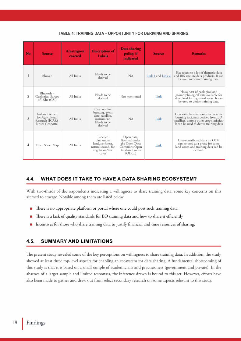
Perhaps, one of the ways to have a stop-gap mechanism such as a common repository that presents an open access and availability of training datasets and ensures standardised, clean datasets to be stored. This shall ensure the availability of training data for different land cover features from the most recent classified outputs or thematic maps by random sampling. A fraction of this can be used for validation and then ascertain the training data quality.
Table 4 lists some popular sources for deriving and sharing training data at scale considering the available country-wide data. Indeed, Dr. P. G. Diwakar who was heading the Earth Observation Systems at ISRO earlier suggest that since there are many derived and thematic data products on Bhuvan, one could use them and extract training data (signatures). For non-dynamic land cover like geomorphology (soil and other geological layers), one could access the Bhukosh – GSI portal data and derive the training data. However, what is often required are for dynamic land cover types like crop type and their growth stage, for instance.

Findings14
Expert Domain Type of
organisa-tion
Area/region covered
Method of training data collection
Availability of training data &
license
Willingness to share training
data
Training Data Quality
EO Data Sources #
Dr Parth Sarathi Roy
Biodiversity characterisation, Land
cover change
Past Govt and University, now with
NGO
All India, North-east in particular
In-person field-level data collection
On request, not in public domain Yes Self-assessed Landsat, Sentinel, IRS,
Spot, ASTER
Dr T V Ramachandra
Land use land cover change, Urban, Water
resources, Climate Change
Academic Karnataka In-person field-level data collection Not in public domain Some Self-assessed Landsat, IRS, Modis,
ASTER, SRTM
Dr C. Jeganathan Forestry, Climate Change, Agriculture Academic Central, North and
North-east IndiaIn-person field-level data
collection Not in public domain Yes Self-assessed Landsat, Sentinel, IRS, Spot, ASTER
Dr. Jagdish Krishnaswamy Ecohydrology NGO Karnataka In-person field-level data
collectionOnly one data paper,
otherwise not in public domain
Yes Self-assessed Landsat, Sentinel, IRS
Dr Harini Nagendra Urban, Land use land cover, Agriculture, Social Academic All India
In-person field-level data collection and through Google
EarthNot in public domain Yes Self-assessed Landsat, Sentinel, IRS,
MODIS
Dr S. Pazhanivelan Land use land cover, Agriculture Academic Tamil Nadu In-person field-level data
collection Not in public domain Based on incentives Self-assessed Landsat, Sentinel, IRS
Mr Sarvesh Kurane Agriculture, Climate, Land use land cover Private All India In-person field-level data
collection Through Satsure Sparta YesSelf-assessed and independently
validated through third-party sources
Landsat, Sentinel, IRS and ground-based
sensors
Mr Yogesh PatilWeather & Climate, Agriculture, Land use
land coverPrivate
All India, but more for central Indian
states
In-person field-level data collection and through Google Earth and a host of sensors for
weather/climate dataNot in public domain Based on
incentives
Self-assessed and independently
validated through third-party sources
Landsat, Sentinel, IRS and ground-based
sensors
Mr Sajjad Anwar Land cover NGO US In-person field-level data collection Some through OSM Yes Self-assessed Landsat, Sentinel
Mr Thejesh GN Open Data Advocacy All India NA NA Yes NA NA
Dr R Prabhakar Ecology and Conservation NGO All India User-generated data
Some data through India Biodiversity
Portal, but training data is not in the public
domain.
Yes Relied on user-contributed data
Landsat, Sentinel, IRS, Spot
Dr Rajani MB Archaeology Academic Karnataka, Bihar, Chhattisgarh
In-person field-level data collection and through Google
EarthNot in public domain Yes Self-assessed Landsat, Sentinel, IRS
Dr P G Diwakar Land cover, Agriculture, Urban
Past Govt, now
AcademicAll India
In-person field-level data collection
Not in public domainNo, only for internal use
Self-assessed IRS, Landsat, MODIS
Dr Vinay Kumar Dadhwal
Land use land cover, Agriculture
Past Govt, now
AcademicAll India
In-person field-level data collection
Not in public domain Yes Self-assessedLandsat, Sentinel, IRS,
Spot
Mr Devdatta Tengse Land use land cover, Agriculture, Urban Private All India
In-person field-level data collection
Not in public domainBased on incentives
Self-assessed and independently
validated through third-party sources
Landsat, Sentinel, IRS
TABLE 2: SUMMARY OF INTERVIEW RESPONSES ON EO TRAINING DATA SHARING IN INDIA

A ST
UD
Y O
N E
AR
TH
OB
SER
VAT
ION
TR
AIN
ING
DAT
A L
AN
DSC
AP
E IN
IND
IA
15Findings
Expert Domain Type of
organisa-tion
Area/region covered
Method of training data collection
Availability of training data &
license
Willingness to share training
data
Training Data Quality
EO Data Sources #
Dr Parth Sarathi Roy
Biodiversity characterisation, Land
cover change
Past Govt and University, now with
NGO
All India, North-east in particular
In-person field-level data collection
On request, not in public domain Yes Self-assessed Landsat, Sentinel, IRS,
Spot, ASTER
Dr T V Ramachandra
Land use land cover change, Urban, Water
resources, Climate Change
Academic Karnataka In-person field-level data collection Not in public domain Some Self-assessed Landsat, IRS, Modis,
ASTER, SRTM
Dr C. Jeganathan Forestry, Climate Change, Agriculture Academic Central, North and
North-east IndiaIn-person field-level data
collection Not in public domain Yes Self-assessed Landsat, Sentinel, IRS, Spot, ASTER
Dr. Jagdish Krishnaswamy Ecohydrology NGO Karnataka In-person field-level data
collectionOnly one data paper,
otherwise not in public domain
Yes Self-assessed Landsat, Sentinel, IRS
Dr Harini Nagendra Urban, Land use land cover, Agriculture, Social Academic All India
In-person field-level data collection and through Google
EarthNot in public domain Yes Self-assessed Landsat, Sentinel, IRS,
MODIS
Dr S. Pazhanivelan Land use land cover, Agriculture Academic Tamil Nadu In-person field-level data
collection Not in public domain Based on incentives Self-assessed Landsat, Sentinel, IRS
Mr Sarvesh Kurane Agriculture, Climate, Land use land cover Private All India In-person field-level data
collection Through Satsure Sparta YesSelf-assessed and independently
validated through third-party sources
Landsat, Sentinel, IRS and ground-based
sensors
Mr Yogesh PatilWeather & Climate, Agriculture, Land use
land coverPrivate
All India, but more for central Indian
states
In-person field-level data collection and through Google Earth and a host of sensors for
weather/climate dataNot in public domain Based on
incentives
Self-assessed and independently
validated through third-party sources
Landsat, Sentinel, IRS and ground-based
sensors
Mr Sajjad Anwar Land cover NGO US In-person field-level data collection Some through OSM Yes Self-assessed Landsat, Sentinel
Mr Thejesh GN Open Data Advocacy All India NA NA Yes NA NA
Dr R Prabhakar Ecology and Conservation NGO All India User-generated data
Some data through India Biodiversity
Portal, but training data is not in the public
domain.
Yes Relied on user-contributed data
Landsat, Sentinel, IRS, Spot
Dr Rajani MB Archaeology Academic Karnataka, Bihar, Chhattisgarh
In-person field-level data collection and through Google
EarthNot in public domain Yes Self-assessed Landsat, Sentinel, IRS
Dr P G Diwakar Land cover, Agriculture, Urban
Past Govt, now
AcademicAll India
In-person field-level data collection
Not in public domainNo, only for internal use
Self-assessed IRS, Landsat, MODIS
Dr Vinay Kumar Dadhwal
Land use land cover, Agriculture
Past Govt, now
AcademicAll India
In-person field-level data collection
Not in public domain Yes Self-assessedLandsat, Sentinel, IRS,
Spot
Mr Devdatta Tengse Land use land cover, Agriculture, Urban Private All India
In-person field-level data collection
Not in public domainBased on incentives
Self-assessed and independently
validated through third-party sources
Landsat, Sentinel, IRS
Note: # Sources listed in the order of data accessed.

Findings16
No SourceTraining
data shared
Nature of training data
Area/region covered
Description of Labels Method of
training data collection
Any quality
assessment
No of data points
Data sharing policy, if indicated
Link Source Remarks
1Vedas by Space
Applications Centre (SAC), ISRO
Yes On Fodder and crop-related Gujarat
Fodder crop type, Field Size, Crop Growth Stage,
Crop Stress, Adjacent Crop
Field visitsData
accuracies are mentioned
> 500
Distributed free of charge as per their Copyright policy
https://vedas.sac.gov.in/en/
copyright.html
Link
Only application
from India that allows collection of EO training
data.
2 Open Natural Ecosystems (ONEs) No
Points as ONEs and not-ONEs
All India
Scrub Land, Degraded Forest, Barren Rocky
Area, and Gullied And Ravenous Land as
ONEs; Lands under cultivation that varied
from horticultural crops and irrigated farmlands
to marginal rainfed agriculture as not-ONEs.
Derived from LULC map and high-resolution base maps in Google Earth
NA181,812 points of ONEs and
116,447 points not-ONEs
Paper and ONE data under CC-
By-NC 4.0Link
A recent paper that
has mapped open natural ecosystems in
India.
3Indian Council for Agricultural
Research (ICAR)-Survey Data
No Crop related information All India
Location, identification details, subject level
details, unit-level dataSurveys and field
visits NA NARestricted under
ICAR data sharing policy
LinkICAR claims to have data but
is restricted for general users.
4Biodiversity
Information System (BIS)
No
Vegetation Type map,
spatial locations of
road & village, Fire occurrence
All IndiaSpecies-abundance values, measured environmental
variables at plot levelField visits NA
16,000+ sample plots
for entire IndiaNot mentioned Link
Has geospatially referenced field sample plots.
5 Urban dataset NoPoints as
urbanised or non-urbanised
Saharanpur, UP Built-up and non-built-up Derived NA
900 built-up and 900 non-built-up (total 1800 points)
NA
Maithani, S. A neural network-based urban
growth model of an Indian city. J
Indian Soc Remote Sens 37, 363–376
(2009). https://doi.org/10.1007/s12524-
009-0041-7
Training data created for
1993-2001 can serve long-term monitoring if
shared.
6
A global reference database of crowd-sourced cropland
data collected using the Geo-Wiki
platform
Yes
Croplands as per
GEOGLAM/JECAM
definition
Global, including
India
Cropland, whether used Google background imagery or viewed in
Google Earth
Crowd-sourced through Citizen
science
32,287 of 35,866
points were validated 4 to
7 times
35,866 sample units
Creative Commons
Attribution 4.0 International
License
Laso Bayas, J., Lesiv, M., Waldner, F. et
al. A global reference database of crowd-
sourced cropland data collected using the
Geo-Wiki platform. Sci Data 4, 170136
(2017). https://doi.org/10.1038/sdata.2017.136
A crowd-sourcing
campaign using the Geo-Wiki
crowd-sourcing tool.
7A global dataset of crowd-sourced land cover and land use
reference dataYes
Land use land cover
GEOGLAM/JECAM
definition
Global, including
India
Human impact, land cover disagreement, wilderness
and reference data
Crowd-sourced through Citizen
science66-80 % 151,942
records (global)
Creative Commons
Attribution 4.0 International
License
Fritz, S., See, L., Perger, C. et al. A global dataset of
crowd-sourced land cover and land use reference data. Sci Data 4, 170075 (2017). https://
doi.org/10.1038/sdata.2017.75
A crowd-sourcing
campaign using the Geo-Wiki
crowd-sourcing tool.
8
Landuse Land Cover at EWRG, Centre
for Ecological Sciences (CES),
Indian Institutte of Science (IISc)
NoPoints of
various land use and land cover
types
Extensive for the Western
Ghats
Land cover land use type ranging from agriculture,
forest, to urbanField visits NA > 10,000 NA NA
Data used in many studies
by Energy and Wetlands
Research Group, CES, IISc
9
Eco-informatics Lab at Ashoka
Trust for Research in Ecology and
the Enviornment (ATREE)
NoPoints of
various land use and land cover
types
Extensive for the Western
Ghats
Mostly forest types to understand vegetation
dynamicsField visits NA > 5,000 NA NA
Data used in many studies by
ATREE
10Tamil Nadu Agriculture
University (TNAU)No Points on crop
type and growth Tamil Nadu Crop type, growth stage, irrigation, etc. Field visits NA > 1,000 NA NA
Data used in many studies by the Department
of Remote Sensing and GIS, TNAU
11 SatSure Ltd NoLand use
land cover, Agriculture
All IndiaLand cover and land use with greater emphasis on
crop informationField visits NA > 10,000 NA NA
Data gathered and generated
for offering their services and
practice
12 GeoSpoc Geospatial Services Pvt. Ltd. No
Land use land cover, Agriculture,
UrbanAll India
Land cover land use type ranging from agriculture,
forest, to urbanField visits NA > 10,000 NA NA
Data gathered and generated
for offering their services and
practice
13 Azim Premji University (APU) No Urban
Top 100 cities in India
Mostly on urban land cover and land use
Field visits and derived NA > 500 NA NA
Data used in many studies by
APU
114National Institute
of Advanced Studies (NIAS
NO Archaeology Select sites in India On archaeological sites Field visits NA > 500 NA NA
Data used in many studies by
NIAS
TABLE 3: AVAILABLE TRAINING DATA.

A ST
UD
Y O
N E
AR
TH
OB
SER
VAT
ION
TR
AIN
ING
DAT
A L
AN
DSC
AP
E IN
IND
IA
17Findings
No SourceTraining
data shared
Nature of training data
Area/region covered
Description of Labels Method of
training data collection
Any quality
assessment
No of data points
Data sharing policy, if indicated
Link Source Remarks
1Vedas by Space
Applications Centre (SAC), ISRO
Yes On Fodder and crop-related Gujarat
Fodder crop type, Field Size, Crop Growth Stage,
Crop Stress, Adjacent Crop
Field visitsData
accuracies are mentioned
> 500
Distributed free of charge as per their Copyright policy
https://vedas.sac.gov.in/en/
copyright.html
Link
Only application
from India that allows collection of EO training
data.
2 Open Natural Ecosystems (ONEs) No
Points as ONEs and not-ONEs
All India
Scrub Land, Degraded Forest, Barren Rocky
Area, and Gullied And Ravenous Land as
ONEs; Lands under cultivation that varied
from horticultural crops and irrigated farmlands
to marginal rainfed agriculture as not-ONEs.
Derived from LULC map and high-resolution base maps in Google Earth
NA181,812 points of ONEs and
116,447 points not-ONEs
Paper and ONE data under CC-
By-NC 4.0Link
A recent paper that
has mapped open natural ecosystems in
India.
3Indian Council for Agricultural
Research (ICAR)-Survey Data
No Crop related information All India
Location, identification details, subject level
details, unit-level dataSurveys and field
visits NA NARestricted under
ICAR data sharing policy
LinkICAR claims to have data but
is restricted for general users.
4Biodiversity
Information System (BIS)
No
Vegetation Type map,
spatial locations of
road & village, Fire occurrence
All IndiaSpecies-abundance values, measured environmental
variables at plot levelField visits NA
16,000+ sample plots
for entire IndiaNot mentioned Link
Has geospatially referenced field sample plots.
5 Urban dataset NoPoints as
urbanised or non-urbanised
Saharanpur, UP Built-up and non-built-up Derived NA
900 built-up and 900 non-built-up (total 1800 points)
NA
Maithani, S. A neural network-based urban
growth model of an Indian city. J
Indian Soc Remote Sens 37, 363–376
(2009). https://doi.org/10.1007/s12524-
009-0041-7
Training data created for
1993-2001 can serve long-term monitoring if
shared.
6
A global reference database of crowd-sourced cropland
data collected using the Geo-Wiki
platform
Yes
Croplands as per
GEOGLAM/JECAM
definition
Global, including
India
Cropland, whether used Google background imagery or viewed in
Google Earth
Crowd-sourced through Citizen
science
32,287 of 35,866
points were validated 4 to
7 times
35,866 sample units
Creative Commons
Attribution 4.0 International
License
Laso Bayas, J., Lesiv, M., Waldner, F. et
al. A global reference database of crowd-
sourced cropland data collected using the
Geo-Wiki platform. Sci Data 4, 170136
(2017). https://doi.org/10.1038/sdata.2017.136
A crowd-sourcing
campaign using the Geo-Wiki
crowd-sourcing tool.
7A global dataset of crowd-sourced land cover and land use
reference dataYes
Land use land cover
GEOGLAM/JECAM
definition
Global, including
India
Human impact, land cover disagreement, wilderness
and reference data
Crowd-sourced through Citizen
science66-80 % 151,942
records (global)
Creative Commons
Attribution 4.0 International
License
Fritz, S., See, L., Perger, C. et al. A global dataset of
crowd-sourced land cover and land use reference data. Sci Data 4, 170075 (2017). https://
doi.org/10.1038/sdata.2017.75
A crowd-sourcing
campaign using the Geo-Wiki
crowd-sourcing tool.
8
Landuse Land Cover at EWRG, Centre
for Ecological Sciences (CES),
Indian Institutte of Science (IISc)
NoPoints of
various land use and land cover
types
Extensive for the Western
Ghats
Land cover land use type ranging from agriculture,
forest, to urbanField visits NA > 10,000 NA NA
Data used in many studies
by Energy and Wetlands
Research Group, CES, IISc
9
Eco-informatics Lab at Ashoka
Trust for Research in Ecology and
the Enviornment (ATREE)
NoPoints of
various land use and land cover
types
Extensive for the Western
Ghats
Mostly forest types to understand vegetation
dynamicsField visits NA > 5,000 NA NA
Data used in many studies by
ATREE
10Tamil Nadu Agriculture
University (TNAU)No Points on crop
type and growth Tamil Nadu Crop type, growth stage, irrigation, etc. Field visits NA > 1,000 NA NA
Data used in many studies by the Department
of Remote Sensing and GIS, TNAU
11 SatSure Ltd NoLand use
land cover, Agriculture
All IndiaLand cover and land use with greater emphasis on
crop informationField visits NA > 10,000 NA NA
Data gathered and generated
for offering their services and
practice
12 GeoSpoc Geospatial Services Pvt. Ltd. No
Land use land cover, Agriculture,
UrbanAll India
Land cover land use type ranging from agriculture,
forest, to urbanField visits NA > 10,000 NA NA
Data gathered and generated
for offering their services and
practice
13 Azim Premji University (APU) No Urban
Top 100 cities in India
Mostly on urban land cover and land use
Field visits and derived NA > 500 NA NA
Data used in many studies by
APU
114National Institute
of Advanced Studies (NIAS
NO Archaeology Select sites in India On archaeological sites Field visits NA > 500 NA NA
Data used in many studies by
NIAS
Findings18
No SourceArea/region
coveredDescription of
Labels
Data sharing policy, if indicated
Source Remarks
1 Bhuvan All India Needs to be derived NA Link 1 and Link 2
Has access to a lot of thematic data and IRS satellite data products. It can
be used to derive training data.
2Bhukosh –
Geological Survey of India (GSI)
All India Needs to be derived Not mentioned Link
Has a host of geological and geomorphological data available for download for registered users. It can
be used to derive training data.
3Indian Council for Agricultural
Research (ICAR)-Krishi Geoportal
All India
Crop residue burning, event date, satellite, instrument.Needs to be
derived
NA LinkGeoportal has maps on crop residue burning incidents derived from EO
satellites, among other crop statistics. It can be used to derive training data
4 Open Street Map All India
Labelled data under
landuse=forest, natural=wood, for
vegetation/tree cover
Open data, licensed under the Open Data
Commons Open Database License
(ODbL)
LinkUser-contributed data on OSM can be used as a proxy for some
land cover, and training data can be derived.
TABLE 4: TRAINING DATA – OPPORTUNITY FOR DERIVING AND SHARING.
4.4. WHAT DOES IT TAKE TO HAVE A DATA SHARING ECOSYSTEM?
With two-thirds of the respondents indicating a willingness to share training data, some key concerns on this seemed to emerge. Notable among them are listed below:
■ There is no appropriate platform or portal where one could post such training data.
■ There is a lack of quality standards for EO training data and how to share it efficiently
■ Incentives for those who share training data to justify financial and time resources of sharing.
4.5. SUMMARY AND LIMITATIONS
The present study revealed some of the key perceptions on willingness to share training data. In addition, the study showed at least three top-level aspects for enabling an ecosystem for data sharing. A fundamental shortcoming of this study is that it is based on a small sample of academicians and practitioners (government and private). In the absence of a larger sample and limited responses, the inference drawn is bound to this set. However, efforts have also been made to gather and draw out from select secondary research on some aspects relevant to this study.

A STUDY ON EARTH OBSERVATION TRAINING DATA LANDSCAPE IN INDIA
19Challenges and Recommendations
The current study reveals that the EO training data sharing landscape has some key challenges and opportunities. Adequately addressing the challenges and harnessing the opportunities would pave the way for achieving the intended sustainable development goals. However, specific concerns have emerged across academia, industry, and the government, as elucidated by the respective stakeholders.
5.1. CHALLENGES
5.1.1. Portal For Data Sharing
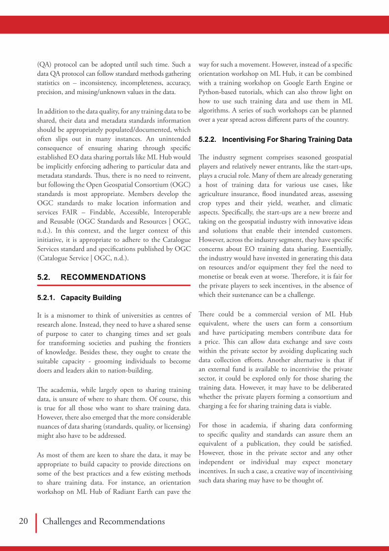
Most of those who wanted to share data expressed the need for a portal for data sharing. NSDI should have facilitated it; instead, the Open Government Data (OGD) portal serves this need for those emanating from the government sector. However, for those in academia, including NGOs and the private sector, the OGD portal does not encourage them. Instead of creating a portal from scratch, specific existing tools and libraries aid in using training data for ML applications, notably Development Seed’s Label Maker and ML Hub by Radiant Earth (See Annexure 7). There is also Collect Earth from Open Foris that can be considered.
Nevertheless, ML Hub by Radiant Earth is indeed promising, and it has already managed to curate some data for Africa. Perhaps, some push through specific
capacity building workshops can enable the adoption of Radiant ML Hub. While there are domain-specific data repositories and some generalist repositories (Recommended Data Repositories | Scientific Data, n.d.), there exists only one such application for EO training data developed by VEDAS at Space Applications Centre, ISRO. However, without adequate push on the VEDAS data collection application, this may not see enough traction. It is thus crucial to ensure all EO training data generators share them in a common portal. Perhaps, the funding calls can spell such portals (like ML Hub or Vedas) and encourage grantees to share such data.
5.1.2. Ensuring Data Quality
As noted earlier, while there are multiple efforts to put out geospatial data through geoportals or state-backed GIS portals, there is very little or no information on their data quality. Even for those where some EO training data is shared, the assertion on data quality is lacking. It should therefore become mandatory to disclose the data quality appropriately should any such geospatial data be shared. There can be community-based guidelines and imposing self-policing of shared data to ensure data quality. The community-based approaches and policing work best when a large community has a shared interest, like the OpenStreetMap movement. However, in the absence of such a community, the standard data quality assurance
Visualisation of Earth Observation Data and Archival System (VEDAS) could potentially serve as a platform for sharing ‘Training data on EO’ at the national level. The application can easily be adapted by all EO data users.
Dr PG DiwakarISRO Chair Professor at NIAS and former Director, Earth Observation & Disaster Management, ISRO.
“CHALLENGES AND RECOMMENDATIONS 5
Challenges and Recommendations 20
(QA) protocol can be adopted until such time. Such a data QA protocol can follow standard methods gathering statistics on – inconsistency, incompleteness, accuracy, precision, and missing/unknown values in the data.
In addition to the data quality, for any training data to be shared, their data and metadata standards information should be appropriately populated/documented, which often slips out in many instances. An unintended consequence of ensuring sharing through specific established EO data sharing portals like ML Hub would be implicitly enforcing adhering to particular data and metadata standards. Thus, there is no need to reinvent, but following the Open Geospatial Consortium (OGC) standards is most appropriate. Members develop the OGC standards to make location information and services FAIR – Findable, Accessible, Interoperable and Reusable (OGC Standards and Resources | OGC, n.d.). In this context, and the larger context of this initiative, it is appropriate to adhere to the Catalogue Services standard and specifications published by OGC (Catalogue Service | OGC, n.d.).
5.2. RECOMMENDATIONS
5.2.1. Capacity Building
It is a misnomer to think of universities as centres of research alone. Instead, they need to have a shared sense of purpose to cater to changing times and set goals for transforming societies and pushing the frontiers of knowledge. Besides these, they ought to create the suitable capacity - grooming individuals to become doers and leaders akin to nation-building.
The academia, while largely open to sharing training data, is unsure of where to share them. Of course, this is true for all those who want to share training data. However, there also emerged that the more considerable nuances of data sharing (standards, quality, or licensing) might also have to be addressed.
As most of them are keen to share the data, it may be appropriate to build capacity to provide directions on some of the best practices and a few existing methods to share training data. For instance, an orientation workshop on ML Hub of Radiant Earth can pave the
way for such a movement. However, instead of a specific orientation workshop on ML Hub, it can be combined with a training workshop on Google Earth Engine or Python-based tutorials, which can also throw light on how to use such training data and use them in ML algorithms. A series of such workshops can be planned over a year spread across different parts of the country.
5.2.2. Incentivising For Sharing Training Data
The industry segment comprises seasoned geospatial players and relatively newer entrants, like the start-ups, plays a crucial role. Many of them are already generating a host of training data for various use cases, like agriculture insurance, flood inundated areas, assessing crop types and their yield, weather, and climatic aspects. Specifically, the start-ups are a new breeze and taking on the geospatial industry with innovative ideas and solutions that enable their intended customers. However, across the industry segment, they have specific concerns about EO training data sharing. Essentially, the industry would have invested in generating this data on resources and/or equipment they feel the need to monetise or break even at worse. Therefore, it is fair for the private players to seek incentives, in the absence of which their sustenance can be a challenge.
There could be a commercial version of ML Hub equivalent, where the users can form a consortium and have participating members contribute data for a price. This can allow data exchange and save costs within the private sector by avoiding duplicating such data collection efforts. Another alternative is that if an external fund is available to incentivise the private sector, it could be explored only for those sharing the training data. However, it may have to be deliberated whether the private players forming a consortium and charging a fee for sharing training data is viable.
For those in academia, if sharing data conforming to specific quality and standards can assure them an equivalent of a publication, they could be satisfied. However, those in the private sector and any other independent or individual may expect monetary incentives. In such a case, a creative way of incentivising such data sharing may have to be thought of.

A STUDY ON EARTH OBSERVATION TRAINING DATA LANDSCAPE IN INDIA
21Challenges and Recommendations
5.2.3. Leveraging Citizen Science
India has 742 districts (in 2021), up from 640 districts as per the 2011 Census. In most districts, there have been District Science Centres. For various reasons, they have been notional and with limited activities, mainly engaging with schools. However, there has been little public engagement at large. In addition, there exists a host of government-run educational institutions – primary, higher primary and high schools – in all these districts. High school students could be mobilised as part of larger citizen science activities. They can be oriented to gather data on different land cover features, including crops or water bodies which would become an excellent training data resource. An orientation workshop across each state can be initiated detailing the activity. The citizen scientists can be asked to submit or share such data through a portal like ML Hub. A vital aspect of this approach is that it is scalable and repeatable over the years. Also, it can save high costs for the government and the private sector, who would otherwise have to spend considerable resources in gathering such data. In such a case, they only pay their resources validating such crowd-sourced data. This would be practical outdoor training for the students, enabling them to appreciate what is around them and document. The latter may not have direct tangible benefits, but certainly, they would have intangible benefits.
5.2.4. Drive through NDSAP and other Missions Under Pm-Stiac
The Government of India made the correct moves to frame the right policies and even the licensing. The NDSAP, NGP and the OGD License are essential aspects of an ecosystem of open data sharing, particularly among the public sector and academia. Specifically, those in academia funded by public money are held accountable, and it is fair for them to share the data as appropriate. Although the NDSAP has been for a while, including the OGD portal, they don’t yet host training data. This would, however, require a nudge from the senior leadership levels in the government, either political or bureaucratic leadership.
It is also essential to note that while there are concerns due to neighbours keeping the larger goal on SDG and other development needs, the government should
seriously consider nudging all concerned agencies to share data under NDSAP under the OGD license. One of the critical aspects of why Landsat and Sentinel are used widely is that they have addressed these concerns well, prompting the Indian geoportals and EO data providers to take a leaf or two from these.
In addition, there are several national-level scientific missions (like the Artificial Intelligence Mission) under the Prime Minister’s Science, Technology, and Innovation Advisory Council (PM-STIAC), anchored by the Office of the Principal Scientific Adviser (PSA) to the Government of India. Therefore, it would be prudent for the Office of PSA to anchor the collation of training data by all government and academic institutions through some of its missions, including those gathered through citizen science. Since it has overarching responsibility across all departments and ministries of the Government of India dealing with research/any aspect of science and technology, the Office of PSA is ideally positioned to anchor such an effort at the national scale.
5.3. SUMMARY
Clearly, with the increasing access to EO data and the availability of cloud-based computational infrastructure to analyse EO data using some ML algorithms, the outlook on EO data sharing is promising. However, it is imperative that the right amount of nudge by the government and complementary support by GIZ towards enabling this can go a long way in achieving sustainable development goals.
References 22
Agarwal, A. (2019). Development of universal geospatial data collection application and visualisation platform. Journal of Geomatics, 13(1).
Agarwal, S., & Nagendra, H. (2019). Classification of Indian cities using Google Earth Engine. Journal of Land Use Science, 14(4–6), 425–439. https://doi.org/10.1080/1747423X.2020.1720842
Amani, M., Brisco, B., Afshar, M., Mirmazloumi, S. M., Mahdavi, S., Mirzadeh, S. M. J., Huang, W., & Granger, J. (2019). A generalised supervised classification scheme to produce provincial wetland inventory maps: an application of Google Earth Engine for big geo data processing. Big Earth Data, 3(4), 378–394. https://doi.org/10.1080/20964471.2019.1690404
Aneece, I., & Thenkabail, P. (2018). Accuracies achieved in classifying five leading world crop types and their growth stages using optimal earth observing-1 hyperion hyperspectral narrowbands on Google Earth Engine. Remote Sensing, 10(12), 2027. https://doi.org/10.3390/rs10122027
Awad, M. M., Alawar, B., & Jbeily, R. (2019). A new crop spectral signatures database interactive tool (CSSIT). Data, 4(2). https://doi.org/10.3390/data4020077
Bakker, W. H., Janssen, L. L. F., Reeves, C. v, Gorte, B. G. H., Pohl, C., Weir, M. J. C., Horn, J. A., Prakash, A., & Woldai, T. (2001). Principles of Remote Remote Sensing - An introductory text-book. In ITC , Enschede, The Netherlands.
Bellinaso, H., Demattê, J. A. M., & Romeiro, S. A. (2010). Soil spectral library and its use in soil classification. Revista Brasileira de Ciencia Do Solo, 34(3), 861–870. https://doi.org/10.1590/s0100-06832010000300027
Catalogue Service | OGC. (n.d.). Retrieved July 12,
2021, from https://www.ogc.org/standards/cat
Cho, E., Jacobs, J. M., Jia, X., & Kraatz, S. (2019). Identifying Subsurface Drainage using Satellite Big Data and Machine Learning via Google Earth Engine. Water Resources Research, 55(10), 8028–8045. https://doi.org/10.1029/2019WR024892
Collect Earth Online. (n.d.). Retrieved July 12, 2021, from https://collect.earth/about
D. Gore, R., Chaudhari, R. H., & Gawali, B. W. (2016). Creation of Soil Spectral Library for Marathwada Region. International Journal of Advanced Remote Sensing and GIS, 5(1), 1787–1794. https://doi.org/10.23953/cloud.ijarsg.60
Dadhwal, V. K., Singh, R. P., Dutta, S., & Parihar, J. S. (2002). Remote sensing based crop inventory : A review of Indian experience. 43(1), 107–122.
Dong, J., Xiao, X., Menarguez, M. A., Zhang, G., Qin, Y., Thau, D., Biradar, C., & Moore, B. (2016). Mapping paddy rice planting area in northeastern Asia with Landsat 8 images, phenology-based algorithm and Google Earth Engine. Remote Sensing of Environment, 185, 142–154. https://doi.org/10.1016/j.rse.2016.02.016
Gillespie, T. W., Foody, G. M., Rocchini, D., Giorgi, A. P., & Saatchi, S. (2008). Measuring and modelling biodiversity from space. Progress in Physical Geography, 32(2), 203–221. https://doi.org/10.1177/0309133308093606
Goldblatt, R., You, W., Hanson, G., & Khandelwal, A. K. (2016). Detecting the boundaries of urban areas in India: A dataset for pixel-based image classification in google earth engine. Remote Sensing, 8(8), 634. https://doi.org/10.3390/rs8080634
REFERENCES

A STUDY ON EARTH OBSERVATION TRAINING DATA LANDSCAPE IN INDIA
23References
Gomes, V. C. F., Queiroz, G. R., & Ferreira, K. R. (2020). An Overview of Platforms for Big Earth Observation Data Management and Analysis. Remote Sensing 2020, Vol. 12, Page 1253, 12(8), 1253. https://doi.org/10.3390/RS12081253
Gorelick, N., Hancher, M., Dixon, M., Ilyushchenko, S., Thau, D., & Moore, R. (2017). Google Earth Engine: Planetary-scale geospatial analysis for everyone. Remote Sensing of Environment, 202, 18–27. https://doi.org/10.1016/j.rse.2017.06.031
Gumma, M. K., Thenkabail, P. S., Teluguntla, P. G., Oliphant, A., Xiong, J., Giri, C., Pyla, V., Dixit, S., & Whitbread, A. M. (2020). Agricultural cropland extent and areas of South Asia derived using Landsat satellite 30-m time-series big-data using random forest machine learning algorithms on the Google Earth Engine cloud. GIScience and Remote Sensing, 57(3), 302–322. https://doi.org/10.1080/15481603.2019.1690780
Herold, M., Roberts, D. A., Gardner, M. E., & Dennison, P. E. (2004). Spectrometry for urban area remote sensing - Development and analysis of a spectral library from 350 to 2400 nm. Remote Sensing of Environment, 91(3–4), 304–319. https://doi.org/10.1016/j.rse.2004.02.013
Hird, J. N., DeLancey, E. R., McDermid, G. J., & Kariyeva, J. (2017). Google earth engine, open-access satellite data, and machine learning in support of large-area probabilistic wetland mapping. Remote Sensing, 9(12), 1315. https://doi.org/10.3390/rs9121315
Jain, K., & Bhatia, K. (n.d.). Development of Digital Spectral Library and Supervised Classification of Rice Crop Varieties Using Hyperspectral Image Processing.
Kasturirangan, K. (1985). The evolution of satellite-based remote-sensing capabilities in India. International Journal of Remote Sensing, 6(3–4), 387–400. https://doi.org/10.1080/01431168508948461
Kotthaus, S., Smith, T. E. L., Wooster, M. J., & Grimmond, C. S. B. (2014). Derivation of an urban materials spectral library through emittance and reflectance spectroscopy. ISPRS Journal of Photogrammetry and Remote Sensing, 94, 194–212.
https://doi.org/10.1016/j.isprsjprs.2014.05.005
Krishnayya, N. S. R. (2007). Spectral signatures of teak (Tectona grandis L.) using hyperspectral (EO1) data VCP II View project DST and SAC View project. https://www.researchgate.net/publication/242096099
Label Maker Documentation — label-maker 0.9.0 documentation. (n.d.). Retrieved July 12, 2021, from https://devseed.com/label-maker/
Madhusudan, M. D., & Vanak, A. (2021). Mapping the distribution and extent of India’s semi-arid open natural ecosystems. Earth and Space Science Open Archive (ESSOAr). https://doi.org/10.1002/ESSOAR.10507612.1
Maxwell, A. E., Warner, T. A., & Fang, F. (2018). Implementation of machine-learning classification in remote sensing: an applied review. Https://Doi.Org/10.1080/01431161.2018.1433343, 39(9), 2784–2817. https://doi.org/10.1080/01431161.2018.1433343
Mekonnen, M. M., & Hoekstra, A. Y. (2011). The green, blue and grey water footprint of crops and derived crop products. Hydrology and Earth System Sciences, 15(5), 1577–1600. https://doi.org/10.5194/hess-15-1577-2011
ML Hub – Radiant Earth Foundation. (n.d.). Retrieved July 12, 2021, from https://www.radiant.earth/mlhub/
Moore, R. T., Hansen, M. C., Moore, R. T., & Hansen, M. C. (2011). Google Earth Engine: a new cloud-computing platform for global-scale earth observation data and analysis. AGUFM, 2011, IN43C-02. https://ui.adsabs.harvard.edu/abs/2011AGUFMIN43C..02M/abstract
Nasarudin, N. E. M., & Shafri, H. Z. M. (2011). Development and utilisation of urban spectral library for remote sensing of urban environment. Journal of Urban and Environmental Engineering, 5(1), 44–56. https://doi.org/10.4090/juee.2011.v5n1.044056
Nidamanuri, R. R., & Zbell, B. (2011). Use of field reflectance data for crop mapping using airborne hyperspectral image. ISPRS Journal of Photogrammetry

References 24
and Remote Sensing, 66(5), 683–691. https://doi.org/10.1016/j.isprsjprs.2011.05.001
Nidamanuri, R. R., & Zbell, B. (2012). Existence of characteristic spectral signatures for agricultural crops - Potential for automated crop mapping by hyperspectral imaging. Geocarto International, 27(2), 103–118. https://doi.org/10.1080/10106049.2011.623792
OGC Standards and Resources | OGC. (n.d.). Retrieved July 12, 2021, from https://www.ogc.org/standards
Pettorelli, N., Safi, K., & Turner, W. (2014). Satellite remote sensing, biodiversity research and conservation of the future. Philosophical Transactions of the Royal Society B: Biological Sciences, 369(1643), 20130190. https://doi.org/10.1098/rstb.2013.0190
Prasad, K. A., Gnanappazham, L., Selvam, V., Ramasubramanian, R., & Kar, C. S. (2015). Developing a spectral library of mangrove species of Indian east coast using field spectroscopy. Geocarto International, 30(5), 580–599. https://doi.org/10.1080/10106049.2014.985743
Rama Rao, N. (2008). Development of a crop-specific spectral library and discrimination of various agricultural crop varieties using hyperspectral imagery. International Journal of Remote Sensing, 29(1), 131–144. https://doi.org/10.1080/01431160701241779
Rao, N. R., Garg, P. K., & Ghosh, S. K. (2007). Development of an agricultural crops spectral library and classification of crops at cultivar level using hyperspectral data. Precision Agriculture, 8(4–5), 173–185. https://doi.org/10.1007/s11119-007-9037-x
Recommended Data Repositories | Scientific Data. (n.d.). Retrieved July 12, 2021, from https://www.nature.com/sdata/policies/repositories
Reddy, C. S., Alekhya, V. V. L. P., Saranya, K. R. L., Athira, K., Jha, C. S., Diwakar, P. G., & Dadhwal, V. K. (2017). Monitoring of fire incidences in vegetation types and protected areas of India: Implications on carbon emissions. Journal of Earth System Science, 126(1), 11. https://doi.org/10.1007/s12040-016-0791-x
Reddy, C. S., Pasha, S. V., Jha, C. S., Diwakar, P. G., & Dadhwal, V. K. (2016). Development of national database on long-term deforestation (1930-2014) in Bangladesh. Global and Planetary Change, 139, 173–182. https://doi.org/10.1016/j.gloplacha.2016.02.003
Reddy, C. S., Sreelekshmi, S., Jha, C. S., & Dadhwal, V. K. (2013). National assessment of forest fragmentation in India: Landscape indices as measures of the effects of fragmentation and forest cover change. Ecological Engineering, 60, 453–464. https://doi.org/10.1016/j.ecoleng.2013.09.064
Roy, P. S., Behera, M. D., & Srivastav, S. K. (2017). Satellite Remote Sensing: Sensors, Applications and Techniques. In Proceedings of the National Academy of Sciences India Section A - Physical Sciences (Vol. 87, Issue 4, pp. 465–472). Springer India. https://doi.org/10.1007/s40010-017-0428-8
Roy, P. S., & Tomar, S. (2000). Biodiversity characterisation at landscape level using geospatial modelling technique. Biological Conservation, 95(1), 95–109. https://doi.org/10.1016/S0006-3207(99)00151-2
Sanchez, P. A., Ahamed, S., Carré, F., Hartemink, A. E., Hempel, J., Huising, J., Lagacherie, P., McBratney, A. B., McKenzie, N. J., de Lourdes Mendonça-Santos, M., Minasny, B., Montanarella, L., Okoth, P., Palm, C. A., Sachs, J. D., Shepherd, K. D., Vågen, T. G., Vanlauwe, B., Walsh, M. G., … Zhang, G. L. (2009). Digital soil map of the world. In Science (Vol. 325, Issue 5941, pp. 680–681). https://doi.org/10.1126/science.1175084
Schmedtmann, J., & Campagnolo, M. L. (2015). Reliable crop identification with satellite imagery in the context of Common Agriculture Policy subsidy control. Remote Sensing, 7(7), 9325–9346. https://doi.org/10.3390/rs70709325
Selvaraj, A., Saravanan, S., & Rani, N. (2020). Development of spectral library of mangrove native species of the Muthupet lagoon, Tamil Nadu, India using field spectroscopic instrument. In Indian Journal of Geo Marine Sciences (Vol. 49, Issue 5).
Shepherd, K. D., & Walsh, M. G. (2002). Development of Reflectance Spectral Libraries for Characterisation

A STUDY ON EARTH OBSERVATION TRAINING DATA LANDSCAPE IN INDIA
25References
of Soil Properties. Soil Science Society of America Journal, 66(3), 988–998. https://doi.org/10.2136/sssaj2002.9880
Shetty, S. (2019). Analysis of Machine Learning Classifiers for LULC Classification on Google Earth Engine. http://essay.utwente.nl/83543/1/shetty.pdf
Somdatta Chakravortty. (2013). Application of hyperspectral data for development of spectral library of mangrove species in the Sunderban Delta. International Journal of Geomatics and Geosciences , 4(2), 305–312.
Srinet, R., Nandy, S., Padalia, H., Ghosh, S., Watham, T., Patel, N. R., & Chauhan, P. (2020). Mapping plant functional types in Northwest Himalayan foothills of India using random forest algorithm in Google Earth Engine. International Journal of Remote Sensing, 41(18), 1–14. https://doi.org/10.1080/01431161.2020.1766147
Sudhakar Reddy, C., Diwakar, P. G., & Krishna Murthy, Y. V. N. (2017). Sustainable Biodiversity Management in India: Remote Sensing Perspective. In Proceedings of the National Academy of Sciences India Section A - Physical Sciences (Vol. 87, Issue 4, pp. 617–627). Springer India. https://doi.org/10.1007/s40010-017-0438-6
Sudhakar Reddy, C., Jha, C. S., Dadhwal, V. K., Hari Krishna, P., Vazeed Pasha, S., Satish, K. v., Dutta, K., Saranya, K. R. L., Rakesh, F., Rajashekar, G., & Diwakar, P. G. (2016). Quantification and monitoring of deforestation in India over eight decades (1930–2013). Biodiversity and Conservation, 25(1), 93–116. https://doi.org/10.1007/s10531-015-1033-2
Tiwari, V., Kumar, V., Matin, M. A., Thapa, A., Ellenburg, W. L., Gupta, N., & Thapa, S. (2020). Flood inundation mapping-Kerala 2018; Harnessing the power of SAR, automatic threshold detection method and Google Earth Engine. PLoS ONE, 15(8 August), e0237324. https://doi.org/10.1371/journal.pone.0237324
Townshend, J., Justice, C., Li, W., Gurney, C., & McManus, J. (1991). Global land cover classification by remote sensing: present capabilities and future possibilities. Remote Sensing of Environment,
35(2–3), 243–255. https://doi.org/10.1016/0034-4257(91)90016-Y
Turner, W., Spector, S., Gardiner, N., Fladeland, M., Sterling, E., & Steininger, M. (2003). Remote sensing for biodiversity science and conservation. In Trends in Ecology and Evolution (Vol. 18, Issue 6, pp. 306–314). Elsevier Ltd. https://doi.org/10.1016/S0169-5347(03)00070-3
Viscarra Rossel, R. A., Behrens, T., Ben-Dor, E., Brown, D. J., Demattê, J. A. M., Shepherd, K. D., Shi, Z., Stenberg, B., Stevens, A., Adamchuk, V., Aïchi, H., Barthès, B. G., Bartholomeus, H. M., Bayer, A. D., Bernoux, M., Böttcher, K., Brodský, L., Du, C. W., Chappell, A., … Ji, W. (2016). A global spectral library to characterise the world’s soil. In Earth-Science Reviews (Vol. 155, pp. 198–230). Elsevier BV https://doi.org/10.1016/j.earscirev.2016.01.012
Zhang, J., He, Y., Yuan, L., Liu, P., Zhou, X., & Huang, Y. (2019). Machine learning-based spectral library for crop classification and status monitoring. Agronomy, 9(9). https://doi.org/10.3390/agronomy9090496
Zhang, J., Okin, G. S., & Zhou, B. (2019). Assimilating optical satellite remote sensing images and field data to predict surface indicators in the Western US: Assessing error in satellite predictions based on large geographical datasets with the use of machine learning. Remote Sensing of Environment, 233. https://doi.org/10.1016/j.rse.2019.111382
Zhou, B., Okin, G. S., & Zhang, J. (2020). Leveraging Google Earth Engine (GEE) and machine learning algorithms to incorporate in situ measurement from different times for rangelands monitoring. Remote Sensing of Environment, 236, 111521. https://doi.org/10.1016/j.rse.2019.111521

Annexures26
ANNEXURE 1: DRAFT OF NATIONAL GEOSPATIAL POLICY AND GUIDELINES
ANNEXURE 2: NATIONAL DATA SHARING AND ACCESSIBILITY POLICY (NDSAP)
ANNEXURE 3: OPEN GOVERNMENT DATA (OGD) LICENSE
ANNEXURE 4: SPACERS POLICY-2020 AND SPACERS NGP-2020
ANNEXURES
LINK
LINK
LINK
LINK https://dst.gov.in/sites/default/files/Draft%20NGP%2C%202021.pdf
https://dst.gov.in/sites/default/files/gazetteNotificationNDSAP.pdf
https://www.meity.gov.in/writereaddata/files/Gazette%20Notification_OpenDataLicense_13_02_2017.pdf
https://www.isro.gov.in/sites/default/files/spacers_policy_ngp_2020_draft.pdf

A STUDY ON EARTH OBSERVATION TRAINING DATA LANDSCAPE IN INDIA
27Annexures
ANNEXURE 5: STUDY METHOD AND QUESTIONNAIRE
Study method
The study was carried out through structured interviews and discussions with a select list of professionals working with the government, academia, and practitioners working in the industry and start-up ecosystems. In addition, efforts were made to gather responses through DataMeet, a leading group of open-data enthusiasts in India.
Questionnaire
1. Which earth observation data are you using/access?
[Please list]
2. How do you access the earth observation data?
[Describe]
3. Are you aware of the data sharing and access policy of the data you are accessing?
4. What are you using/applying earth observation data for?
■ Research / Academic purposes
■ Training
■ Practice / Generating reports
■ Policy Advisory
■ No, not using/applying at the moment
■ Interested in using it in the future
■ Other: __________
5. What areas/domains are you using/applying earth observation data?
■ Ecology and Conservation
■ Land-use Land cover change studies
■ Water resources
■ Urban planning
■ Social systems – education, healthcare, etc.
■ Other: __________
6. Do you publish the results of your analysis for public (open) access?
Yes / No
7. Do you also publish/share the data used for analysis for public (open) access?

Annexures28
Yes / No
8. If yes, under what license are you publishing the data?
[List]
9. If yes, please share the details of the website/source from where they can be accessed.
[List]
10. What is the quality of the data set?
On training data
11. Are you / your organisation involved in the collection of earth observation training data?
Yes/No
12. Are you making use of the earth observation training data for any machine learning / AI-based model?
13. If yes, please describe:
14. How often are you collecting the earth observation training data?
15. If yes (for 11), are you making the datasets openly and freely accessible?
Yes/No
16. If yes, where is it available?
[List]
17. If yes (for 15), what is the quality of the training data?
18. If no (for 15), do you have plans or are you willing to open/share the datasets?
19. Are there issues/challenges in making the training data open (accessible)?
Yes/No
20. If yes, please chose which of these challenges/issues are applicable:
■ Technical
» Lack of server space/resources (hardware)
» Data format (interoperability)

A STUDY ON EARTH OBSERVATION TRAINING DATA LANDSCAPE IN INDIA
29Annexures
■ Institutional and economic problems like:
» Absence of policy concerning pricing,
» Copyright,
» Privacy,
» Liability,
» Conformity with standards,
» Data quality
■ Communication problems
» Related to production,
» Distribution,
» Dissemination
21. What are the major challenges for sharing earth observation training data?
[Describe]
22. In your opinion, what measures can enable an ecosystem of earth observation and training data more shareable and accessible?
[Describe]
23. In your opinion, what is the future outlook for earth observation training data when made open/accessible?
[Describe]
24. Any additional comments/feedback.
[Describe]

Annexures30
No Name Designation Organisation
1 Prof K VijayRaghavan Principal Scientific Adviser to the Government of India
Office of Principal Scientific Adviser to the Government of India
2 Dr K R Murali Mohan Head, Frontier and Futuristic Technologies (FFT) Division
Department of Science & Technology (DST), Government of India
3 Dr P G Diwakar ISRO Chair ProfessorNational Institute of Advanced Studies and Former
Director, Earth Observation & Disaster Management, ISRO
4 Dr Parth Sarathi Roy Senior FellowSustainable Landscapes and Restoration, WRI India
and Former Deputy Director, National Remote Sensing Centre, ISRO
5 Dr Vinay Kumar Dadhwal Indira Gandhi Chair Professor National Institute of Advanced Studies Formerly, Director, Indian Insitute of Remote Sensing
6 Dr T V Ramachandra Coordinator Energy and Wetlands Research Group,
7 Dr C. Jeganathan Professor and Dean (Research, Innovation & Entrepreneurship) Department of Remote Sensing
8 Dr Jagdish Krishnaswamy Senior Fellow, Suri Sehgal Centre for Biodiversity and Conservation
Ashoka Trust for Research in Ecology and the Environment (ATREE)
9 Dr Harini Nagendra Director, Research Center, and Professor of Sustainability Azim Premji University
10 Dr S. Pazhanivelan Professor and Head, Remote Sensing and GIS Department of Remote Sensing and GIS
11 Dr Rajani MB Associate Professor National Institute of Advanced Studies
12 Dr R Prabhakar Director Strand Life Sciences and India Biodiversity Portal
13 Mr Sarvesh Kurane Vice President SatSure Ltd
14 Mr Yogesh Patil CEO Skymet Weather Services Pvt. Ltd.
15 Mr Sajjad Anwar Data and Strategy Development Seed, Formerly with Mapbox
16 Mr Thejesh GN Co-Founder DataMeet
17 Mr Devdatta Tengshe Solutions Architect - GIS GeoSpoc Geospatial Services Pvt. Ltd
ANNEXURE 6: LIST OF EXPERTS WHO PARTICIPATED IN QUALITATIVE DISCUSSIONS

A STUDY ON EARTH OBSERVATION TRAINING DATA LANDSCAPE IN INDIA
31Annexures
ANNEXURE 7: TOOLS AND LIBRARIES FOR SHARING EO TRAINING DATASET
Noting the challenges for creating the EO training dataset, there are some tools and applications that can be used to create the EO training dataset. Though they are specific to certain domains, mostly in ecology/natural history, some are listed below.
Vedas
At the Space Applications Centre, ISRO in Ahmedabad, an Android app and web interface application has been developed to gather EO training data (A. Agarwal, 2019). Perhaps, this is the only application in India dedicated to such EO training data collection and a web interface for the users to view and download. However, it is not apparent from the website and the publication on any sharing policy, although the portal allows for data sharing.
Vedas – Data Collection: https://vedas.sac.gov.in/data-collection/
Collect Earth from Open Foris
A custom-built, open-source satellite image viewing and interpretation system called Collect Earth Online was developed by SERVIR. It is a joint NASA and USAID program in partnership with regional technical organisations worldwide and the FAO as a tool for use in projects that require land cover and/or land use reference data (Collect Earth Online, n.d.).
Collect Earth Online: https://collect.earth/home

Annexures32
Label Maker by Development Seed
Label Maker generates training data for ML algorithms focused on overhead imagery (e.g., from satellites or drones). It downloads OpenStreetMap QA Tile information and overhead imagery tiles and saves them as a Numpy .npz file for easy use in ML pipelines (Label Maker Documentation — Label-Maker 0.9.0 Documentation, n.d.).
Label maker: https://github.com/developmentseed/label-maker/tree/master/examples
Radiant Earth – ML Hub
Radiant Earth ML Hub is the world’s first cloud-based open library dedicated to EO training data for use with machine learning algorithms. Designed to encourage widespread data collaboration, Radiant ML Hub allows anyone to access, store, register, and share open training datasets for high-quality Earth observations (ML Hub – Radiant Earth Foundation, n.d.).
ML Hub – Radiant Earth Foundation: https://www.radiant.earth/mlhub/
Deutsche Gesellschaft für
Internationale Zusammenarbeit
(GIZ) GmbH
A2/18 Safdarjung Enclave
New Delhi-110029 India
T: +91-11-49495353
www.giz.de/India


