JKAU: Earth Sci., vol. 10, pp. 91-103 (1419 A.H. / 1998 A.D.) 91 A Study on Sand Dune Forms Southeast of Jeddah, Saudi Arabia W.M. SHEHATA, A.A. SABTAN and M.M. GHAZAL Faculty of Earth Sciences, King Abdulaziz University, Jeddah, Saudi Arabia Accepted: 26th Dec., 1997 Received: 21st Dec., 1996 ABSTRACT. The drifting sand and dune movement pose serious geohazard on urban development and road construction in the Kingdom of Saudi Arabia. This fact initiated several research projects in a number of universities and re- search institutes in the Kingdom. Two locations of inter mountain dune fields east and southeast of Jeddah were investigated and the dune forms were identified. In addition to the sand sheets, the major dune type is the reversal linear dunes coexisting with few small barchan dunes. Detailed investigations on the linear dunes indicated that the ultimate direc- tion of movement of the dunes is downwind along their crest line. However, during their migration, the dunes wander laterally in both directions but more in one direction than the other depending on the frequency of the prevailing wind and configuration of the surrounding mountains. The sand from the two locations was found to be similar in their grain size parameters. Some variations, however, were observed both along the crest line and across the dune body. Mineralogically, the sand reflects the composition of the surrounding igneous, metamorphic and sedimentary rocks. The results of cone penetration tests were used to reconstruct a possible cross section for the linear dune which is slightly different from the existing hypothetical sections. A reasonable similarity was obtained between the studied dunes and the lin- ear dunes existing in Al Nufud but some differences were found between the sand from these dunes and the other dune forms in Al Jafurah and Ad Dahna sand seas. The sections of the highways crossing these dune fields are either parallel or intersect the dune crest lines at small angle. The dunes, therefore, pose only mi- nor sand drifting hazard on these highways. A forest is suggested to be es- tablished to control this hazard and minimize the waste water ponding problems. 1. Introduction The eolian sand areas cover approximately one third of the Arabian Peninsula and form an important physiographic province in Saudi Arabia. Sand exists in the form of sand
Transcript
A Study on Sand Dune... 91JKAU: Earth Sci., vol. 10, pp. 91-103 (1419 A.H. / 1998 A.D.)
91
A Study on Sand Dune Forms Southeast of Jeddah, Saudi Arabia
W.M. SHEHATA, A.A. SABTAN and M.M. GHAZAL
Faculty of Earth Sciences, King Abdulaziz University, Jeddah, Saudi Arabia
ABSTRACT. The drifting sand and dune movement pose serious geohazard onurban development and road construction in the Kingdom of Saudi Arabia.This fact initiated several research projects in a number of universities and re-search institutes in the Kingdom.
Two locations of inter mountain dune fields east and southeast of Jeddahwere investigated and the dune forms were identified. In addition to the sandsheets, the major dune type is the reversal linear dunes coexisting with fewsmall barchan dunes.
Detailed investigations on the linear dunes indicated that the ultimate direc-tion of movement of the dunes is downwind along their crest line. However,during their migration, the dunes wander laterally in both directions but morein one direction than the other depending on the frequency of the prevailingwind and configuration of the surrounding mountains.
The sand from the two locations was found to be similar in their grain sizeparameters. Some variations, however, were observed both along the crest lineand across the dune body. Mineralogically, the sand reflects the composition ofthe surrounding igneous, metamorphic and sedimentary rocks. The results ofcone penetration tests were used to reconstruct a possible cross section for thelinear dune which is slightly different from the existing hypothetical sections.
A reasonable similarity was obtained between the studied dunes and the lin-ear dunes existing in Al Nufud but some differences were found between thesand from these dunes and the other dune forms in Al Jafurah and Ad Dahnasand seas.
The sections of the highways crossing these dune fields are either parallel orintersect the dune crest lines at small angle. The dunes, therefore, pose only mi-nor sand drifting hazard on these highways. A forest is suggested to be es-tablished to control this hazard and minimize the waste water ponding problems.
1. Introduction
The eolian sand areas cover approximately one third of the Arabian Peninsula and forman important physiographic province in Saudi Arabia. Sand exists in the form of sand
W.M. Shehata et al.92
seas in the north (Al Nufud sand sea), in the east (Al Jafurah and Ad Dahna sand seas),and in the south (Al Rub al Khali). In the western part of Saudi Arabia, sand exists asdunes and sand sheets scattered along the Red Sea coast or between the mountains of Ti-hama along the western part of the Arabian Shield. Since sand poses natural erosional-depositional hazards on the existing structures, roads and urbanized areas, it became nec-essary to study the behavior of the sand forms in the different parts of the country.
Several investigations have been made on the Nufud sand sea (Whitney, 1981; Whit-ney et al., 1983; Vincent, 1984), Al Jafurah sand sea (Fryberger et al., 1984; Anton andVincent, 1986; Shehata et al., 1992), Ad Dahna sand sea (Al-Saud, 1988 and El-Nozahy, 1993), and Al Rub al Khali sand sea (McClure, 1978, 1984; Edgell, 1990).Limited studies have been performed on the dunes in the western area (Binda, 1983;Zaidi, 1983), probably because of their limited severity as a natural hazard.
The objectives of this work are to present the dune types, mode of movement andproperties of the dune forming sand in the central Tihama area represented by two intermountain dune fields to the east and southeast of Jeddah. These findings will also becompared with the results of the several investigations performed on Al Jafurah and AlNufud sand seas. A remedial measure will be suggested to solve the problem associatedwith the dunes and minimize the hazard related to the existing waste water flow alongJeddah-Taif road.
2. Local Geomorphology
Regionally the dune areas are restricted to wadi courses which cut through the Pre-cambrian igneous and metamorphic rocks of the Arabian Shield. One dune field is locat-ed in an inter mountain area along the Khawajat section of Jeddah-Taif road (Location#1) and the second is situated within Wadi Fatima along the old Jeddah-Makkah road(Location #2) (Fig. 1). The main rocks that surround the studied dune fields are gray topink calc-alkalic granites, diorite and granodiorite, and amphibolite schists as mappedby Brown et al. (1979). Sedimentary rocks namely sandstone, arkose, limestone andconglomerate of the Fatima Formation also exist in the vicinity of the second dune field.
The general geomorphology of the western Saudi Arabia was investigated by Brown(1960) but he never got into the details of the dunes in the wadi courses. The dunes inboth localities are of the active linear type which support Mainguet’s (1984) idea thatthis dune type exists in rocky areas where the unidirectional regime of the wind is dis-turbed by the irregular topography. However, the present dunes, which are few hundredmeters in length and few tens of meters in width, are different in size from those (1-2km in length) described by Mainguet (1984). The dunes are much similar in form andsize to those present in Al Nufud sand sea and described as active longitudinal dunes byWhitney et al. (1983) and Shehata (1990). The dunes are also of the reversal type sim-ilar to those of the Kelso dunes in the Mojave desert of California and described bySharp (1966). In the mean time, these dunes are different from the barchan dunespresent on the coastal area along Jeddah-Al-Lith road, and those reported by Zaidi(1983) in Khulays area.
A Study on Sand Dune... 93
The dunes are arranged in staggered forms extending in the N70W to N80W direc-tions with enlarged downwind ends. The crest lines of the dunes are sinuous in naturewith a wave length approximately 40 m in length. A limited study of the internal struc-tures across the crest of one linear dune showed the presence of sand layers dipping inthe opposite directions similar to the hypothetical section drawn by McKee (1979). Theripple marks present on the downwind limb of the dune trend in a direction per-pendicular to the crest line and are partly covered near the crest. On the windward limb,the ripple marks are parallel to the crest line in some sections and pependicular to it insome others.
The dunes move over a layer of caliche which is locally overlain by a thin sand sheet.This caliche layer, although different in composition, is morphologically similar to thecaliche layer present under the dunes in Al Nufud area and the sabkha layer below thedunes in Al Jafurah sand sea. The reasons for the association of these caliche or sabkhalayers with the dune areas are yet to be investigated. If the caliche layer is assumed tobe a later stage of sabkha salt crust development, the studies of the hydrologic condi-tions within the dunes may clarify this relationship.
The groundwater in the studied location along the Khawajat road is very shallow as itforms relatively densely vegetated water ponds in the topographically low areas. Thecity of Makkah waste water which flows to the southeast towards the Red Sea crossingboth Jeddah-Taif road and Jeddah-Al-Lith road is the reason in forming a perched shal-low groundwater aquifer. Although no water samples were chemically analyzed, thequality of water seems to be suitable for cultivation as some locals established smallvegetable fields irrigated by this water. Further investigations are recommended to ob-tain the aquifer parameters and to test for the groundwater chemical quality.
FIG. 1. Simplified geologic and location map (modified after Brown et al., 1979).
W.M. Shehata et al.94
3. Mode of the Reversal Dune Movement
The prevailing wind direction in Jeddah area is mainly from the NNW, although,gusty winds occasionally come from the south (Anon, 1986). Field observations, how-ever, indicate that the general sand movement in western Saudi Arabia is from north-west to southeast. This is based on the field observations of the barchan dune fields lo-cated both along Jeddah-Al-Lith and Jeddah-Madinah roads.
Two dunes, one from each location, were staked both along the crest line and thedune boundaries. Figure 2 shows the arrangement of the stakes on Dune #10 in location#1 as an example. The stakes were observed for a period of three months until they hadbeen tampered by the locals. The dunes were also observed during storm periods to pre-dict the way of sand transport. Unfortunately, the removal of the stakes from their loca-tions prevented any further monitoring.
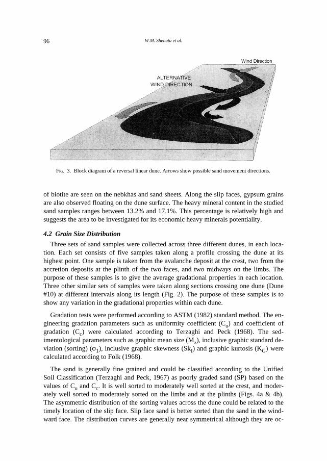
The way that sand drifted during this short monitoring period supports Tsoar (1978)results and Mainguet (1984) observation in north Sebba, Libya. However, it was inter-esting to notice that the sinuous nature of the crest line played an important role in sandtransport. The source of sand transported by wind is the upwind limb of the dune. Partof this sand crosses the dune where the crest line makes a larger angle (> 45º) with theprevailing wind direction to form a slip face on the downwind limb. This part is liftedagain by the wind and moved along the downwind limb parallel to the crest line (Fig.3). The other part, striking the crest line at a smaller angle (< 45º) does not cross thedune and moves along the upwind side again parallel to the crest line. The movement ofthe two parts tend to move the dune downwind along its crest line. During a two monthsperiod, one dune moved 1.6 m, while during a three months period the second dunemovement was unnoticeable.
The location of the slip faces were also periodically observed with respect to the crestline. The slip face locations were observed to be discontinuous. They exist alternativelyon certain sections along the sinuous crest line while the other sections are in the form ofhumps without clear brink line. During the monitoring period, the slip faces were re-versed at least three times. Slip faces along the dunes are developed on the NE limbswhen the wind is more from the WNW direction and along the SW when the wind is fromNNW direction. However, the frequency of the wind from the NNW direction exceedsthat from the WNW direction which resulted in a lateral movement of the dunes in theSW direction by values ranging between 1 m and 2.5 m during a period of two months.
4. Properties of the Dune Sand
4.1 Mineralogical Composition
The dune sand of the two locations is quite similar both in color and mineralogicalcomposition. It is grayish yellow in color and consists mainly of quartz, feldspars, bio-tite and hornblende in addition to chlorite, actinolite, staurolite, sphene, zircon, epidoteand opaque minerals as minor constituents. These minerals make an assemblage similarto that of the surrounding igneous, metamorphic and sedimentary rocks. Concentrations
A Study on Sand Dune... 95
FIG. 2. A sketch diagram for dune #10 in location #1 to show the samples and stakes location with respect tothe dune geometry.
W.M. Shehata et al.96
of biotite are seen on the nebkhas and sand sheets. Along the slip faces, gypsum grainsare also observed floating on the dune surface. The heavy mineral content in the studiedsand samples ranges between 13.2% and 17.1%. This percentage is relatively high andsuggests the area to be investigated for its economic heavy minerals potentiality.
4.2 Grain Size Distribution
Three sets of sand samples were collected across three different dunes, in each loca-tion. Each set consists of five samples taken along a profile crossing the dune at itshighest point. One sample is taken from the avalanche deposit at the crest, two from theaccretion deposits at the plinth of the two faces, and two midways on the limbs. Thepurpose of these samples is to give the average gradational properties in each location.Three other similar sets of samples were taken along sections crossing one dune (Dune#10) at different intervals along its length (Fig. 2). The purpose of these samples is toshow any variation in the gradational properties within each dune.
Gradation tests were performed according to ASTM (1982) standard method. The en-gineering gradation parameters such as uniformity coefficient (Cu) and coefficient ofgradation (Cc) were calculated according to Terzaghi and Peck (1968). The sed-imentological parameters such as graphic mean size (Mz), inclusive graphic standard de-viation (sorting) (σ1), inclusive graphic skewness (SkI) and graphic kurtosis (KG) werecalculated according to Folk (1968).
The sand is generally fine grained and could be classified according to the UnifiedSoil Classification (Terzaghi and Peck, 1967) as poorly graded sand (SP) based on thevalues of Cu and Cc. It is well sorted to moderately well sorted at the crest, and moder-ately well sorted to moderately sorted on the limbs and at the plinths (Figs. 4a & 4b).The asymmetric distribution of the sorting values across the dune could be related to thetimely location of the slip face. Slip face sand is better sorted than the sand in the wind-ward face. The distribution curves are generally near symmetrical although they are oc-
FIG. 3. Block diagram of a reversal linear dune. Arrows show possible sand movement directions.
A Study on Sand Dune... 97
casionally finely skewed. Although on the average the sand is positively skewed, thecrest sand can be negatively skewed (Profiles 5 and 8), or positively skewed (Profile 2).The limbs and troughs are also either negatively skewed or positively skewed. Thesefindings contradicts Ahlbrandt (1979) in his investigation on the barchan dunes wherecrests tend to be better sorted than windward and slip faces, and have positive skewness.It also contradicts Folk (1962) statement that negative skewness are seldom encounteredin eoilian sand. The results indicate that negative skewness is present which could be dueto the reversal character of the linedar dunes during their movement. This reversal be-havior may cause the continuous mixing up of the crest sand with the limbs and troughssand. The sand is generally mesokurtic, however, at the crest it is mesokurtic to plat-ykurtic, while it is platykurtic to leptokurtic on the limbs and at the plinths (Figs. 5a, 5b& 5c). Windward sand tends to have higher kurtosis (more leptokurtic) than slip facesand which agrees with the results reported by Folks (1971) and Binda (1983). The grainsize parameters varies slightly along the crest line of dune #D10 (Fig. 5d). The grain sizegets finer and the uniformity coefficient gets smaller towards the nose. The relationshipbetween the graphic mean size, kurtosis and uniformity coefficient is worth observingand further investigation. Kurtosis values are found to, more or less, follow the trend ofthe uniformity coefficient while the graphic mean size values are mirror image to it.
The resistance to cone penetration was performed using the Mackintosh probe whichconsists of a cone 27 mm in diameter, driven into the ground by a 4 kg hammer at a 28cm fall height. The number of blows required to drive the cone for 100 mm (M) is re-corded and may be used as an index of the penetration resistance (Clayton et al., 1984).The probe is also a good tool to map the subsurface stratigraphic sequence relative tothe degree of sand compactness. Sabtan and Shehata (1994) concluded that this probe,being light, is considered to be a fast and reliable tool to explore most soil types.
Using the results of the penetration resistance tests (Fig. 6a) performed in five loca-tions along a section #2 dune #10 (Fig. 2), a cross section could be constructed (Fig.6b). This cross section shows that the avalanche deposits have a much lower penetrationresistance and consequently lower relative density than the accretion deposits. De-nekamp and Tsur-Lavie (1981) measured the relative density of dune sand following theASTM D1557 designation and reached the same conclusion. The cross section alsoshows minor successive changes in the penetration resistance in the avalanche depositswhich is probably due to the relative difference in the degree of compaction of the suc-cessive layers. The penetration resistance starts to increase with depth due to the pres-ence of accretion deposits underneath it. These findings suggested the deviation fromthe cross sections presented by Bagnold (1941) and McKee (1979) for barchan dunesand allowed the reconstruction of a cross section for the linear dunes as predicted fromthe penetration resistance tests (Fig. 6b).
FIG. 6. [A] Mackintosh probe penetration resistance data. [B] Suggested cross section across a linear dune.
W.M. Shehata et al.100
5. Comparison with Al Jafurah and Al Nufud Dunes
The rock composition in the vicinity of the dune fields normally influences the com-position of the dune sand. For example, the heavy minerals concentration in the sandfrom the two studied locations consists of an average of 13.2% and 17.1% respectivelywhich exceeds the heavy minerals concentration in Al Jafurah sand sea (0.96% to1.25%) (Anon, 1990) existing within a limestone terrain. The studied sand is grayishyellow in color and is different from Al Nufud and Ad Dahna reddish sand sub-stantiating the difference in origin.
The grain size of the linear dunes is generally similar to the barchan dunes but finerthan the other dune forms (Table 1). The sorting is higher, the skewness is lower, andthe uniformity coefficient is lower. No clear variations in both the kurtosis and the co-efficient of gradiation values among the different dune forms.
TABLE 1. Comparison between average grain size parameters in Jeddah linear dunes’ sand and other eoliansand forms in the Kingdom.
Dune type, location Md Mz σ1 Sk1 KG Cu Cc Reference
Linear dunes, Location #1 0.19 0.20 0.73 0.08 1.07 2.70 1.07 This study
Linear dunes, Location #2 0.20 0.17 0.69 0.11 0.97 2.42 0.98 This study
Linear dunes, Al Nufud 0.27 0.22 0.35 0.17 0.92 1.35 1.29 Shehata (1990)
The rate of the linear dune movement, based on the short monitoring period, is rel-atively slow as compared to the barchan dunes. The reversal nature of the dunes and theenergy consumed in their winding movement could be a reason to retard their forwardmovement.
The sections of the highways crossing the two dune fields in the studied locations arerunning either parallel or at low intersection angle to the dune crest lines. This fact aswell as the slow nature of the dunes minimized the possible blown sand or dune migra-tion hazards on the highways. However, the possibility of drifting sand hazard still existand some remedial measures should be considered. Groundwater level is very shallowin location #1 due to the runoff of the waste water originated at the city of Makkah.Similarly groundwater level is expected to be relatively shallow in Wadi Fatima area
A Study on Sand Dune... 101
(location #2). It is therefore suggested to establish a forest in each of these locations andin particular in location #1. This forest will grow with the minimum effort of care, andwill have the capability to retard the sand movement and control the dunes migration.The presence of vegetation will improve the cultivation properties of the existing cleansandy soil. The forest will also consume a large volume of the waste water and preventit from forming ponds along both the Khawajat and Jeddah-Al-Lith roads. Further in-vestigations are necessary to evaluate the aquifer productivity and water quality. It isalso necessary to select the feasible tree species that may grow under the existing condi-tions.
7. Conclusions and Recommendations
The main sand dune type in the inter-mountain areas in central Tihama is the re-versible linear as encountered in two inter mountain dune fields. These dunes follow awinding movement as they move along their crest lines. The reversal nature of thedunes was substantiated by the cone penetration resistance tests and by some of thegrain size parameter values.
The mineralogy of the dunes is different than that of the other sand seas and the highpercentage of heavy minerals content worth further investigation and economic evalua-tion. It is also recommended for the engineers to use some of the geological grain sizedistribution parameters as they better describe the sand.
The dunes pose little hazard on the sections of Jeddah-Taif and Jeddah-Makkah high-ways crossing locations #1 and #2 respectively because of their respective directions.However, the establishment of a forest along Jeddah-Taif road is recommended to notonly control any sand drifting hazard but also to utilize the waste water ponding alongboth this road and Jeddah-Al-Lith road.
References
Ahlbrandt, T.S. (1979) Textural parameters of eolian deposits. in: A Study of Global Sand Seas, E.D. McKee(ed.), U.S. Geol. Surv. Prof. Paper 1052, pp. 21-51.
Al-Saud, M.M.S. (1988) Drifting sand and its grain size characteristics, Ad Dahna desert along Riyadh-Dammam road [in Arabic]. M.Sc. Thesis, King Saud University, Riyadh, Saudi Arabia.
Anon (1982) Standard method for particle size analysis of soils. ASTM designation D422-63, Easton, MD,pp. 112-121.
––––––– (1986) Saudi Arabian Wind Energy Atlas. UPM Printing Press, Saudi Arabia, 67 p.––––––– (1990) Geomorphology and sand dunes movement. In Eolian Sand Control at King Fahd Military
City, Dhahran, Project. No. 23044. Final Report Submitted to Ministry of Defense & Aviation, Riyadh.Anton, D. and Vincent, P. (1986) Parabolic dunes of the Jafurah Desert, Eastern Province, Saudi Arabia.
Journal of Arid Environments, 11: 187-198.Bader, T., Shehata, W., Lofti, H., Ali, A. and Abdallah, M. (1994) Engineering and mineralogical prop-
erties of dune sand, Eastern Province, Saudi Arabia. Presented to the 2nd Geotech. Eng. Conf., Cairo,April 1994.
Bagnold, R.A. (1941) The Physics of Blown Sand and Desert Dunes. Chapman & Hall, London, 265 p.Binda, P.L. (1983) Grain size study of some eolian sands from Saudi Arabia. KAU, Faculty of Earth Science
Bull., 5: 73-82.Brown, G.F. (1960) Geomorphology of western and central Saudi Arabia. Proc. 21st International Geologic
Congress, Copenhagen, Part XXI, pp. 150-159.
W.M. Shehata et al.102
––––––, Jackson, R.O., Bogue, R.G. and Maclean, W.H. (1979) Geology of the Southern Hijaz Quadrangle.Saudi Arabia Deputy Ministry for Mineral Resources Geologic Map GM-210-A.
Denekamp, S.A. and Tsur-Lavie, Y. (1981) The study of relative density in some dune and beach sands.Eng. Geol., 17: 159-173.
Edgell, H.S. (1990) Evolution of the Rub’ al Khali Desert. Journal of King Abdulaziz University Earth Sci-ences, 3: 109-126.
El-Nozahy (1993) Grain morphology, grain size and mineralogical composition of linear dune sands, AdDahna Desert, Saudi Arabia. N. Jb. Geol. Palaont. Abh., Bd., 188(3): 265-288.
Folk, R.L. (1962) Of skewnesses and sands. Jour. Sed. Petrol., 32: 145-146.––––––– (1968) Petrology of Sedimentary Rocks. Hemphill’s Drawer M. University Station, Austin TX, 170.––––––– (1971) Longitudinal dunes of the northwestern edge of the Simpson Desert, Northern Territory, Aus-
in the Jafurah sand sea, Saudi Arabia. Sedimentology, 31: 413-431.Goudie, A. and Wilkinson, J. (1977) The Warm Desert Environment. Cambridge University Press, 88 p.Hotzl H., Kramer, F. and Maurin, V. (1978) Quaternary sediments. in: Quaternary Period in Saudi Arabia,
S.S. Al-Sayari and J.G. Zotl (eds.), Springer Verlag, Vienna, pp. 264-301.Mainguet, M. (1984) A classification of dunes based on eolian dynamics and the sand budget. in: Deserts
and Arid Lands, F. El-Baz (ed.), Martinus Nijhoff Publishers, pp. 31-58.McClure, H.A. (1978) Ar Rub’ al Khali. in: Quaternary Period in Saudi Arabia, S.S. Al-Sayari and J.G.
Zotl (eds.), Springer Verlag, Vienna, pp. 252-263.––––––– (1984) Late Quaternary Paleoenvironments of the Rub’ al Khali. Ph.D. Thesis, University College,
London.McKee, E. (1979) Sedimentary structures in dunes. in: A Study of Global Sand Seas, E. McKee (ed.), U.S.
Geol. Surv. Professional Paper 1052, pp. 83-133.Sabtan, A.A. and Shehata, W.M. (1994) Mackintosh probe as an exploration tool. Bull. Intern. Assoc. Eng.
Geol., 50: 89-94.Sharp, R.P. (1966) Kelso dunes, Mohave Desert, California. Geol. Soc. America Bull., 77(10): 1045-1073.Shehata, W.M. (1990) Report on trip to Hail. Tech. Report submitted to Geology & Minerals Division,
KFUPM/RI, 9 p.–––––––, Bader, T., Irtem, O., Ali, A., Abdallah, M. and Aftab, S. (1992) Rate and mode of barchan dunes
advance in the central part of the Jafurah sand sea. Journal of Arid Environments, 23: 1-17.Terzaghi, K. and Peck, R.B. (1968) Soil Mechanics in Engineering Practice. John Wiley & Sons, New York.Tsoar, H. (1978) The dynamics of longitudinal dunes. Final Tech. Report, Eur. Res. Off., U.S. Army, Lon-
don, 171 p.Vincent, P.J. (1984) Particle size variation over a transverse dune in the Nafud as Sirr, central Saudi Arabia.
Jour. Arid Envir., 7: 329-336.Whitney, J.W. (1981) Saudi Arabia’s stable sand seas [abs.]. Geological Society of America Abstracts with
Program, 13: 580.–––––––, Faulkender, D.J. and Rubin, M. (1983) The environmental history and present condition of Saudi
Arabia’s sand seas. Saudi Arabia Deputy Ministry for Mineral Resources, Open-File Report 83-749,39 p.
Zaidi, S.M.S. (1983) Landforms and geomorphic evolution of Wadi Khulays area, Western Saudi Arabia.KAU, Faculty of Earth Science Bull., 5: 153-166.


![Conducting Qualitative Fieldwork with Ageing Saudis: A Visual Diary · 2020. 3. 14. · [A] Jeddah, Saudi Arabia . This photo captures the heritage buildings in the old part of Jeddah](https://static.documents.pub/doc/80x56/6112164830d9d207232424ad/conducting-qualitative-fieldwork-with-ageing-saudis-a-visual-diary-2020-3-14.jpg)


