A TOURIST DESTINATION PLANNING AND DESIGN MODEL: APPLICATION TO THE AREA AROUND THE MIÑO RIVER IN THE SOUTH OF GALICIA AND THE NORTH OF PORTUGAL Xulio Pardellas de Blas. 1 Carmen Padín Fabeiro. 2 Vigo University, Spain Based on a study of tourist activity as a factor influencing local development carried out in 2001 on Galicia and northern Portugal, our research team presents herein a synthesis of the main contributions offered by a territorial analysis of tourist destinations, drawing up a model which allows us to evaluate the characteristics of this border region. The main contribution of this study is the validation of the model used in order to propose planning measures, contrasting the initial hypothesis in regarding this region as a tourist destination as a whole, in terms of the structure of the features it has in common, analysed in the model, as well as the behaviour KEY WORDS: border region, destination regions, tourism planning 1 Xulio Pardellas de Blas. Professor, Department of Applied Economics, Vigo University, Campus Lagoas Marcosende s/n 36200. Vigo. Galicia. Spain. E-mail: [email protected]. The research includes sustainable development, cultural and environmental tourism, destination place planning. 2 Carmen Padín Fabeiro. Phd student, Department of Applied Economics, Vigo University, Campus Lagoas Marcosende s/n 36200. Vigo. Galicia. Spain. E-mail: [email protected]The research includes the development and impact of tourism on the economy and strategic analysis, with a special reference to natural resources -thermal spas-.
Transcript
A TOURIST DESTINATION PLANNING AND DESIGN MODEL:
APPLICATION TO THE AREA AROUND THE MIÑO RIVER IN THE SOUTH
OF GALICIA AND THE NORTH OF PORTUGAL
Xulio Pardellas de Blas.1
Carmen Padín Fabeiro.2
Vigo University, Spain
Based on a study of tourist activity as a factor influencing local development
carried out in 2001 on Galicia and northern Portugal, our research team presents herein
a synthesis of the main contributions offered by a territorial analysis of tourist
destinations, drawing up a model which allows us to evaluate the characteristics of this
border region.
The main contribution of this study is the validation of the model used in order
to propose planning measures, contrasting the initial hypothesis in regarding this region
as a tourist destination as a whole, in terms of the structure of the features it has in
common, analysed in the model, as well as the behaviour
1 Xulio Pardellas de Blas. Professor, Department of Applied Economics, Vigo University, Campus Lagoas Marcosende s/n 36200. Vigo. Galicia. Spain. E-mail: [email protected]. The research includes sustainable development, cultural and environmental tourism, destination place planning. 2 Carmen Padín Fabeiro. Phd student, Department of Applied Economics, Vigo University, Campus Lagoas Marcosende s/n 36200. Vigo. Galicia. Spain. E-mail: [email protected] The research includes the development and impact of tourism on the economy and strategic analysis, with a special reference to natural resources -thermal spas-.
2
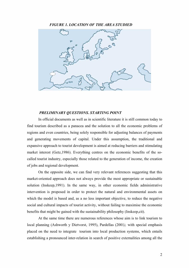
FIGURE 1. LOCATION OF THE AREA STUDIED
PRELIMINARY QUESTIONS. STARTING POINT
In official documents as well as in scientific literature it is still common today to
find tourism described as a panacea and the solution to all the economic problems of
regions and even countries, being solely responsible for adjusting balances of payments
and generating movements of capital. Under this assumption, the traditional and
expansive approach to tourist development is aimed at reducing barriers and stimulating
market interest (Getz,1986). Everything centres on the economic benefits of the so-
called tourist industry, especially those related to the generation of income, the creation
of jobs and regional development.
On the opposite side, we can find very relevant references suggesting that this
market-oriented approach does not always provide the most appropriate or sustainable
solution (Inskeep,1991). In the same way, in other economic fields administrative
intervention is proposed in order to protect the natural and environmental assets on
which the model is based and, as a no less important objective, to reduce the negative
social and cultural impacts of tourist activity, without failing to maximise the economic
benefits that might be gained with the sustainability philosophy (Inskeep,cit).
At the same time there are numerous references whose aim is to link tourism to
local planning (Ashworth y Dietvorst, 1995), Pardellas (2001), with special emphasis
placed on the need to integrate tourism into local production systems, which entails
establishing a pronounced inter-relation in search of positive externalities among all the
3
region's resources. In this context, endogenous development models are fully valid,
given that they contemplate the total integration of all the economic, institutional, social
and cultural agents (Vázquez Barquero, 1999).
In spite of considerable progress in the development of methodological
processes of tourist planning (Getz,1986) (Inskeep,1991),we can observe a certain lack
of models, theories and spatial concepts that might be transformed into a work tool for
planners of a tourist area. Pearce (1995) analyses spatial tourism models, where a
notable fragmentation in his theoretical treatment stands out and we can observe that
many are drawn up in a compartmentalised way, that is, paying little heed to earlier
experiences, apart from the fact that very few have been subjected to critical assessment
or an empirical verification.
Another trend of analysis begins with the studies carried out by Jansen-
Verbeke(1992), who observed that in spite of numerous activity planning models, such
as housing or traffic, few exist in relation with recreational activities and tourism as a
whole. On the other hand, studies by Gunn (1993) contributed to the description of the
physical structure of destination regions. His conclusions are widely quoted, and he is
one of the few who has focused on the description and development of tourist
destination structural models.
In this context, studies by Dredge (1999) provide us with an interesting
theoretical base which simplifies the common elements found in scientific literature on
regional destinations and which is especially relevant in order to analyse and even
propose regional planning processes, integrating tourism as a principle activity. From
this point of view, it provides us with solid arguments and instruments which enable us
to verify whether or not a certain model's proposal is in keeping with a specific action
objective.
THE THEORETICAL MODEL
In line with the definition of the World Tourism Organisation (1995), a tourist
destination is an important place visited by tourists. We can differentiate between three
types of destinations: from a geographical point of view, the one furthest away from
their place of origin; from an economic perspective, the place where they stay the
longest and, therefore, where they spend a greater amount of money and, finally; from a
psychographical perspective, the destination which constitutes the main reason for their
journey. (Swarbrook and Horner, 1999).
4
Therefore, destinations refer to a geographical location with particular
characteristics which gives a tourist reasons for visiting it. As such, it ought to have
proper references and limits, although two perspectives can be differentiated between
here as well, the real, or physical, perspective and the perspective that is perceived,
influenced by the image given by companies or official tourist offices themselves. An
example of the former might be an island's physical shape, where real limits impose a
basic determining factor as to how it is perceived by the tourist. An example of the latter
could be the limits created by the market in the widest sense (“Green Spain” is a way of
offering a group of destination regions with common and unique characteristics, which
makes it different from others).
On the other hand, it is also possible to delimit destinations by scales or ranks,
given that apart from being a tourist destination in itself a certain place forms a part of
another of a higher geographical (or market) scale. In this study, we could never, even
though from the perspective of the study it might be a destination in itself, not locate the
sub-regional area made up of the Baixo Miño, in Galicia, and the Alto Minho, in
Portugal within the superior destination that is the Euro-region comprising Galicia and
northern Portugal, and the Iberian Peninsula even. However, here is where we find a
unique reference: the Miño river, a natural border, which comes across as a limit
perceived, bearing in mind that it is relevant for the demand (Pardellas, 2001).
Initially, and in accordance with Gunn's idea (1993), five key elements and the
way in which they inter-relate can be identified when analysing how to plan a
destination. These elements are: a defined territorial border, an access from the markets
with an internal traffic corridor, attraction complexes, an attractive interior and the
entrances and exits or gateways in and out of the territory. From another perspective it
is also considered that there are various nodes or points where attraction complexes and
the services offered to tourists are concentrated. Consequently, synthesising the ideas of
McCannell (1976), Leiper (1990, 1995), Gunn (1993, cit), Cue et al (1993) and Pearce
(1995), and using Dredge's model(1999) more concretely, we will be able to comment
on these elements as a whole in more detail in order to subsequently apply this model to
the case we are studying.
Obviously, tourist activity is conditioned by the market and the evolution of
consumer tastes is what determines changes in the offer and the aggregate of the
services the tourist sector is made up of (WTO, 1995 cit), which is why, firstly, the
5
concept of Tourism Demand Markets, used as a general reference to the habitual place
of residence of potential users of tourist services, must be defined. It should also be
borne in mind that tourists generally travel to a particular destination in order to
experience new sensations, but their expectations and preferences, as well as the reasons
for choosing such a destination, will always be conditioned by the influence of the
characteristics that exist in their places of origin. Thus, the characterisation of the
demand markets as a relevant factor in the planning and design of the destination is
fundamental, especially for local administrations.
Secondly, the term Destination Regions will be used for the geographical area
in which the tourist activity is concentrated, defined as the place chosen by a person to
visit and spend at least one night with the aim of experiencing some aspect or
characteristic perceived as a satisfactory manner of occupying free time. A tourist can
choose to go to various different places but only the place where he decides to spend the
night will be considered a destination region, thus its borders are subjected to the
journey's characteristics and models and so regions can be large or small, overlap or not,
depending, for example, on the transport system and distance. Planners must be aware
that regions exist on different levels in a destination and that the existence of
administrative borders can limit the planning and design of the destination region (even
when the physical borders have been eliminated, as in the case studied).
Within the geographical area in question the structure of the tourist services on
offer which, logically, are situated in specific places, called Nodes, in reference to the
clusters of attractions and services which together form a local sub-destination, is
shaped. The spatial structure of these nodes takes the form of three concentric rings. The
core is the centre: it can be an attraction, a landscape or an area with monuments
important to the tourist. It is surrounded by an area of contemplation which acts as both
the direct physical and psychological scenario for the tourist experience. In turn, this
area of contemplation is also surrounded by a enclosure which is the external area of
influence where the services and facilities which sustain tourism are to be found.
For their part, the nodes have two main elements which are often independent:
the attraction complexes and the service components. An Attraction Complex consists
of any tourist attraction on offer which makes it possible for a tourist to visit it or see it.
The term refers to one or more individual attractions which generate the interest of a
tourist and encourage him to travel there and they can be situated in a certain
geographical location or in various locations within a destination region, which would
6
define the configuration of the Cores, defined in consequence as a tourist destination's
central attraction elements. The complementary nature of the attraction usually
increases the general appeal of the core, thus the attraction complexes and cores are
often synergetically related, increasing tourist interest in a much more pronounced way
which, with the simple aggregation of the services on offer, can in a similar fashion be
organised in a hierarchical structure in accordance with the importance of the
attractions.
In order to complete the node concept, it is essential to mention the Service
Elements, which cover a wide range of facilities such as accommodation, retail trade
and any other service necessary for tourism. If it is true that they are important
destination elements and that their activity is of important economic value, it also true
that their complementary nature indicates that in general they are not the fundamental
appeal of the destination, as the attractions are. However, in recent years the division
between services and attractions has tended to fade, as occurs with theatres-cum-
complexes, eco-tourism establishments and other theme developments which integrate
attractions and services as the characteristic image of a core and which are presented in
a way in which the tourist will perceive them as unique.
The abovementioned perception will always depend on the way in which a
potential tourist has learned about the destinations, thus the definition of the concept
Markers, that is, all the information elements surrounding an attraction, which might be
of a promotional nature or perhaps of a simply informative nature and which in general
act as fundamental factors that have determined the choice and encouraged the tourist to
travel to the destination, as well as his movements within such destination area. In
general, we can differentiate between two types of markers: separate markers and
adjacent markets. The former are found in the demand markets or throughout the
tourist's journey, while the latter refer to information about attractions to be found in the
destination itself.
The markers carry out various different functions, from prompting the journey,
choosing a destination and planning the journey to choosing the activities or itineraries
within the destination region and identifying the attraction core or cores. With this
approach, the separate markers mainly influence the choice of destination and the
journey's itinerary, whereas the adjacent markers influence the choice of the cores and
the attractions to visit, which is why they are of special relevance with regard to the
7
behaviour of the tourist, providing adequate information on the attractions and
encouraging trips and itineraries within the region, sometimes even encouraging the
tourist to prolong his stay.
Lastly, and bearing in mind that tourist activity necessarily implies that tourists
will have to travel to a particular destination, leading, in turn, in the majority of cases to
other trips within the destination region, the concept of Gateways refers to the
entrances to a destination region, the arrival areas. They can be centred in the access to a
specific core or experience a gradual transition from one destination to another.
The gateways play a particularly relevant both physical and psychological role in
the configuration of a destination region, as they constitute its first point of contact with
the tourist, they indicate the end of the tourist's most important journey, they provide a
first look at the destination, they help guide the tourist into the destination region, etc.
The gateways are the first image of the destination region the tourist will get (often the
one that stays in the memory) whose planning and design, therefore, must be carried out
with the utmost care and consideration. The model admits that there may be multiple
gateways in the region and that the one used to enter may not be the same one used to
exit. Furthermore, the gateway used will depend on a range of factors, from the choice
of transport system to the season in which the journey takes place, as well as the
information and alternatives offered by the markers with respect to the way in which to
access the attractions.
Once inside the destination region, the Traffic Routes are the elements which
allow tourists to move between the attraction complexes and the services, and between
different cores. The routes are decided upon in terms of the personal reasons which have
encouraged tourists to choose a particular destination, as well as the access facilities for
the different kinds of vehicles that might be used. Thus, factors which might influence
the choice of the route are: the availability of direct links, the quality of the landscape,
the transport system or, as is logical, information from the markers. The most common
model assumes that not all the nodes can be linked to each other and that the journey
along the routes can be in one direction or both ways. That is, not all travellers choose
to take the same way back to their accommodation.
8
TOURIST DESTINATION PLACE PLANNING: THE MODEL APPLIED
TO THE MIÑO REGION
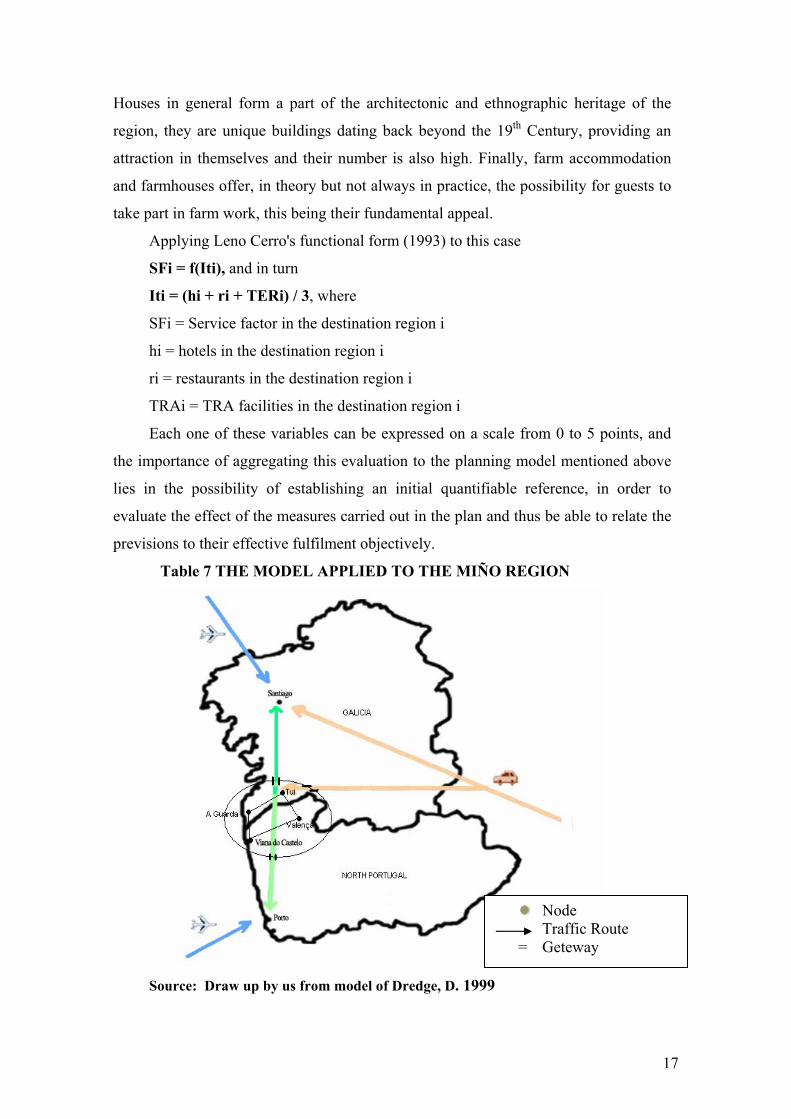
In order to analyse a planning model centred on the territory made up of the
Baixo Miño (Galicia) and the Alto Minho (northern Portugal) regions, the studies
mentioned above were used, although most of the line of argument was, in turn, based
on the model which Dredge (1999, cit) drew up, on the basis of such studies, mainly on
account of its particular simplicity and easy adaptation to the characteristics of the
region we are studying. Firstly, the model involves no regional limits or territorial
restrictions, on account of which it is apt for a border region such as the one in question.
Also, it includes information on behavioural norms noted during travel and the usual
connections in destination regions where the use of the private vehicle is predominant,
as this is the most common means of travel and access to the area.
This border region, which hereinafter we will call the Miño Region, has the
characteristics necessary in order to apply the models considered:
• It must be a region in which recreational tourism is predominant, a requisite with
which the Miño Region complies, where more than ¾ of the total number of
tourists fit this typology (Pardellas et al., 2001)
• It starts from a systematic approach which allows us to regard the integration of
the destination region within other tourism models, that is, it does not exclude
other analysis. This is coherent with the basic principle of the theory of systems:
a group of parts inter-related with each system, and with this group in turn
possibly formed with a greater one. (McLoughlin,1969)
• The demand markets and destination regions must be geographically separate
entities, which is true in the case of this region.
• The complex nature of the destinations and their different levels requires a
hierarchical yet flexible structure which can be adapted to the different places,
levels and characteristics of the market, another requirement that this region
meets, both on the Galician side (superior hierarchy of the Rías Baixas
destination) as well as on the Portuguese side (superior hierarchy of the
Northern Region).
• The planning and design model must include a destination region, tourist
demand markets, nodes, districts, traffic routes and gateways, which can be seen
in greater detail in the following pages.
9
Although the physical borders between Spain and Portugal formally disappeared
in 1985 when they joined the European Union, as is logical the administrative borders
and different domestic legislation remained in place, this in spite of the existence of a
Work Community between Galicia and northern Portugal established in 1989, which
gave rise to notable progress in the new territorial configuration of the future Euro-
region, failures of adjustment and disagreements in the institutional decisions which
affect all economic activities and especially tourism can still be observed today. Thus,
the analysis will necessarily assume an evolution towards the most favourable scenario
for the Euro-region's formal constitution in a reasonably short period of time, so that the
planning model contemplates the co-ordination that is absolutely essential in the
business and administrative decisions that affect the tourist sector.
The main Tourism Demand Markets for the Miño region are situated in the
centre and east of the Iberian peninsula, about 86% of visitors, with a marginal value in
Europe (9%)( Turgalicia, 2001, Dir. Gêral de Turismo, 2001). Therefore, the cultural
and behavioural profile is, in consequence, very homogenous, and their preferences for
the tourist services on offer take little or no notice of what side of the river Miño (the
old border) they are on, as a permanent mobility when using the internal routes exists.
In terms of analysis, this means accepting the hypothesis of a total permeability in the
destination (Pardellas and Padín, 2002). This evaluation will be especially important in
the planning model proposed, given that the common tourist destination hypothesis
constitutes its argumentative basis.
Undoubtedly, the Miño Region's basic common tourist resource is precisely the
river, which in the analysis constitutes the fundamental Node of the destination region,
with both its natural and historical elements, that is, the wealth of its landscape,
including all living and inert elements (wildlife, wetlands, beaches along the river
estuary) and at the same time the wealth of its heritage, with its archaeological treasures,
and the remains of its military structures, the evidence of the wars between Portugal and
Spain from the 17th Century onwards and, logically, the psychological element
associated with being a border area.
The most important city and, consequently, the main tourist Core of the region
is Viana do Castelo, situated to the south of the river Miño estuary. It is doubly
appealing on account of its heritage and the wealth of its monuments as well as the
beaches and natural landscapes in the surrounding coastal area.
10
However, along the banks of the river there are three unique border Attraction
Complexes, which make up the tourist Cores that are next in line to Viana do Castelo
in terms of importance. The structure of the tourist services offered is common to both
sides of the river (also perceived as such by tourists) with communications networks
also common to both (all built with European aid under the INTERREG programme),
and with services whose characteristics are homogenous (Pardellas et al, cit). They are
areas comprising cities geographically and historically opposed: Tui-Valença do Minho,
Goián-Vila Nova de Cerveira and A Guarda-Caminha, defined by a tourist appeal based
on several elements of natural and historical heritage, which are complementary, such
as, for example, the monuments of Tui-Valença and the fortresses and beaches of
Goián-Vila Nova and A Guarda-Caminha, which are, at the same time, the three points
where the river can be crossed, the first two by bridge and the third by ferry.
From this perspective, the main Traffic Route of the region along the banks of
the river (the C-550 on the Galician side and the IC-1 on the Portuguese side) would be
classified, which, in accordance with the model mentioned above, can have two
entrance or exit Gateways at each end: to the eastern-most part of the region we would
enter from the north via the A-9 motorway (A Coruña-Tui), and from the south via the
A-3 motorway (Lisbon-Valença). In the same way, to the western-most part of the
region, we would enter from the north via the E-30 motorway which links up with the
C-550 (Vigo-Baiona-A Guarda) and from the south via the IC-1 motorway (Viana do
Castelo-Caminha).
In any case, and as we have already commented on, it would not strictly
speaking be dealt with as a traffic route, given that it is possible to break it by crossing
the river in the middle using the Goián-Vila Nova bridge. In hypothesis, this accentuates
the nature of the Miño Region as a common destination, given that practically all of the
tourists visit the cores as a whole or, in other words, tourists perceive that by crossing
the river they complete their enjoyment of the attractions on both sides (Pardellas and
Padín, cit). At this point it is important to underline that the planning model proposed
tends to base itself on the real behaviour of tourists, although it might not always be
considered in such a way in the reports drawn up by the region's two official Tourist
Offices, which often ignore each other in the decisions they make. Although on a larger
scale, the parts of the regional development plans which correspond to tourist objectives
are a clear example (Lisboa, 1998) (Xunta de Galicia, 1999).
11
Once the basic structure of the region's tourism model has been established the
conceptual analysis centres on the elements that form the cores: the tourist products
made up of the attraction complexes, as well as the distribution of their markers and, on
the other hand, the service elements which complement the tourist services offered.
In order to study the tourist products and widening the procedure to the tourist
services and attractions of other secondary level cores inside the region a schematic
chart with the main attractions available in the Miño region was drawn up, adapting R.
Vera's typology of resources (1997)3. The analysis focused conceptually on the two
types of markers mentioned in the model: on the one hand observing the type of
information presented in the web sites on the destination, which potentially can reach all
the demand markets, thus constituting the main separate markers (represented in the
chart by horizontal lines); and on the other hand, in the brochures and leaflets available
to tourists in the destination's tourist offices, categorised as adjacent markers (shaded in
the chart). The incorporation of Internet as a marker is classified in the evolution
towards new forms of getting information. Thus, a Euro-barometer study (European
Commission, 1999) reflects the interest of Europeans in preparing their journeys using
the internet - 42.3% of Europe's population-, becoming the second most attractive
service, after the possibility of consulting and obtaining information from official tourist
offices.
3 In an earlier study the potential of an area as a whole was established in accordance with resource value indicators, differentiating between the various categories, locations, tourist potential and environmental costs involved (Pardellas et all, 2002)
12
TABLE 3. SCHEMATIC CHART WITH THE MAIN ATTRACTIONS
AVAILABLE IN THE MIÑO REGION
Natural
Heritage
(Water)
Tangible
Ethnogr.
Heritage
Historical/
Cultural
Heritage
Intangible
Ethnogr.
Heritage
Natural
Heritage
(Countryside)
MAIN CORES
Trad. craftwork
Miño boat trips
Horse-shearing
Mountain climbing
Fairs and markets
Local fiestas
Water-mills
Fishing
Canoeing
Rivers
Monument-visiting route
REST OF THE AREA
Trad. Craftwork
Horse-shearing
Hill-climbing
Fairs and markets
Local fiestas
Water-mills
Fishing
Canoeing
Hiking
Web sites: Activities listed.//Leaflets, guides: shaded area.
Source: Drawn up by us based on local and regional tourist guides.
By giving numerical values to the chart shown here in qualitative terms, it would
be possible to analyse four elements of the reference function: the use or not of the
resource and the type of marker used (separate or adjacent). In the first case, the zero
value (blank space on the chart) would, obviously, correspond to resources potentially
relevant in the planning model, but unused at present, while the different values given to
13
the type of use allows us to discover the evolution of tourist products in the medium-
term and, consequently, the degree of maturity the destination region is reaching.
In the second case, it is similarly possible to give values to the type of markers
that are used in order to provide information on the products to the demand markets,
which will depend on the importance attached to them in the planning model, given that
the attractions of a particular core can be promoted with both types of markers and, for
example, we still have very little written information on the real impact of the new
information and communications technologies (ICT) on decisions regarding the
consumption of tourist products, while the use of web sites has grown geometrically in
recent years in promoting tourism in the destination regions.
In accordance with the above, the equation for the use tourist resources function
would be expressed as follows:
TViA=Σ ƒ(IF, EF), where
TViA=Tourist value of "i" area
IF= Internal factors of tourist value
EF= External factors of resource uses.
with the mathematical expression :
IF= Σ Phi ui+ Σ max U(Phi ui)
Phi= Primary hierarchy of the resource “i”
µi= Weighting factor relating to the nature of the resource “i”
max U(P hi ui) = Maximum values of the resource function “i”.
EF= Σ ƒ(Vij , α mij+ β nij)
Vij =Tourist value of the resource i in location j mij= variable which integrates the separate marker characteristics
nij = variable which integrates the adjacent marker characteristics in the
destination region.
α , β = weighting parameters.
In the qualitative analysis the position of each one of the elements can now be
observed graphically in the chart. The abundance of blank spaces, especially in the
secondary cores, would seem to indicate that the use of the potential resources of the
destination region in order to create attractions is scarce, which can be denoted as:
max U(P hi ui) = Maximum values of the resource function “i”
14
Thus, the minimum values are represented in blank and the maximum values
with the corresponding boxes shaded, taking on values depending on whether the
marker is separate (α mij , horizontal lines in the chart), and/or adjacent ( β nij, shaded in
the chart).
It can be observed from the chart, drawn up mainly on the basis of the
information gathered from the two studies mentioned above, Pardellas (2001) and
Pardellas (2002), how the resources used the least are, however, the most abundant,
corresponding to those relating to cultural and historical heritage, which in Galicia alone
represents 39% of the total. This can test the immature destination hypothesis, in
accordance with Leno Cerro (1993) and Vera's (1997, cit.) classification, as they are the
resources which require greater private sector investment in order to be transformed into
tourist products and attractions, and, therefore, greater economic investment -in
preparation, personnel training, promotion-, which at the same time implies a greater
level of inter-relation among the production sectors.
On the contrary, there is greater use of natural resources, especially those related
to the countryside and water, being resources which need little or no preparation and
can be easily promoted. Having said this, if they are used recklessly and lack a proper
management model which contemplates the prior evaluation of carrying capacities and
overcrowding thresholds then there is a much greater risk of excessive use and
deterioration (Fuentes y Vasserot, 2001).
We turn now to focusing the analysis on the type of markers used an bearing in
mind the location of the resources promoted. We can see from the chart that the
bearings take on maximum values in the main cores, with the resource use external
factor indicator: FE= Σ ƒ(Vij , α mij+ β nij), which strengthens the hierarchical
hypothesis regarding the attraction complexes and, consequently, the differentiation of
main cores which use both types of markers, adjacent and separate markers, and with a
greater degree of probability, both at the same time. On the contrary, in the rest of the
region the probability that both types of markers will be used is lower.
From the territorial perspective, although not expressed in the chart, in the case
of the region studied we would underline the absence of proper preparation of common
attractions and, as such, attractions potentially identifiable with the region as a
destination as a whole (Pardellas, cit), which can undoubtedly constitute another
external effect aggregated to the values of the markers, even though they are difficult to
estimate.
15
For its part, the analysis of the Services Elements is limited to the offer of
traditional tourist services such as those provided by hotels and restaurants and those
relating to tourist establishments in rural areas (TRA), considering that the validity of
the results does not increase considerably by introducing other types of factors which
would, however, tend to extend the reach of this study unnecessarily.
As the table shows, the structure of the offer of accommodation is very similar in
both regions, and the practical non-existence of quality service elements notable,
alongside a high rate of low-category elements (to be precise, 73.2% of the hotels in the
area as a whole are one-star). This observation has a bearing once again on the contrast
between the two initial hypotheses mentioned, homogeneity and immaturity of the
destination, in spite of the important resources concentrated there.
TABLE 4. HOTELS BY CATEGORIES
HOTELS 5* 4* 3* 2* 1* TOTAL
Source: Drawn up by us from information from: Xunta de Galicia. Tourist Accommodation Guide
2000. ADETURN (Portuguese Association for Tourism Development in the Northern Region).
Accommodation guide: Porto and northern Portugal
TABLE5. RESTAURANTS
3rd cat/
Typical
4th cat. TOTAL
ALTO MIÑO 3 331 334
BAIXO MIÑO 20 65 85
Main cores 14 166 60
Source: Drawn up by us from the lists of restaurants and cafeterias provided by the Regional
Tourist Office. 1999 and from information provided by Região de Turismo do Alto Minho
(referring to the year 2000)
ALTO MIÑO 0 3 7 3 53 66
BAIXO MIÑO 0 0 3 7 21 31
TOTAL 0 3 10 10 74 97
MAIN CORES 0 3 5 8 37 53
16
Since 1997, in Portugal restaurants have no longer been classified in accordance
with status. The only distinction existing at present that of a "typical restaurant", a term
given to establishments by the Portuguese State Tourist Office on the basis of qualities
such as the menu, the possibility of entertainment, etc., and of which is there are only
three in the sub-area of the Alto Minho. This makes an overall analysis more difficult,
but notwithstanding it is possible to affirm that 94.5% of the total number would be
classified with the same status and aside from this, specifically, the high ratio of hotels
to restaurants, almost 1:3 in the Baixo Miño and 1:5 in the Alto Minho. This might
derive from the very nature of the region as a border area and its historical trade
relations (Torres Gómez, 1998 ), which did not require the traveller to spend a night on
the other side of the border but did require him to have at least one meal there.
Insofar as tourist services in the rural area (TRA) are concerned, the importance
of the quantity of services on offer in the region can be seen. As the table shows, rural
accommodation establishments exceed the number of hotels, indicating and confirming
the special nature of the region as a tourist destination, especially on the Portuguese
side. In fact, in some cases the establishments themselves are the very attraction as a
result of the architectural quality of the buildings. In this sense, it should be underlined
that an inland borough in the Alto Minho, Ponte de Lima, could form an important
core of attraction as it has 43 rural tourism establishments but lacks, however, other
important complementary tourist products.
TABLE 6. RURAL TOURISM
Rural tourism /
Country house Manor house
Farm tourism/
farmhouse TOTAL
ALTO MIÑO 54 41 15 110
BAIXO MIÑO 7 1 0 8
TOTAL 61 42 15 118
Núcleos pples 19 7 5 31
Source: Drawn up by us from information provided by: ADETURN. Accommodation guide: Porto and northern
Portugal, s/d. Xunta de Galicia. Tourist accommodation guide 2000. In this case, the administrative classification allows us to make a comparative
analysis of the services on offer as there are three categories of almost identical
characteristics in the regulations of the two countries. As such, we can see that the
establishments of lesser architectural interest (R. Tourism/Country Houses, are the
most numerous, although quite often they only offer accommodation. B&B and Manor
17
Houses in general form a part of the architectonic and ethnographic heritage of the
region, they are unique buildings dating back beyond the 19th Century, providing an
attraction in themselves and their number is also high. Finally, farm accommodation
and farmhouses offer, in theory but not always in practice, the possibility for guests to
take part in farm work, this being their fundamental appeal.
Applying Leno Cerro's functional form (1993) to this case
SFi = f(Iti), and in turn
Iti = (hi + ri + TERi) / 3, where
SFi = Service factor in the destination region i
hi = hotels in the destination region i
ri = restaurants in the destination region i
TRAi = TRA facilities in the destination region i
Each one of these variables can be expressed on a scale from 0 to 5 points, and
the importance of aggregating this evaluation to the planning model mentioned above
lies in the possibility of establishing an initial quantifiable reference, in order to
evaluate the effect of the measures carried out in the plan and thus be able to relate the
previsions to their effective fulfilment objectively.
Table 7 THE MODEL APPLIED TO THE MIÑO REGION
Source: Draw up by us from model of Dredge, D. 1999
Node Traffic Route = Geteway
18
CONCLUSIONS
The border area between Spain and Portugal divided by the river Miño and made
up of the Baixo Miño region in Galicia and the Alto Minho in northern Portugal
shares a unique natural and historical heritage, with extensive tourist potential, above
all, proving to be highly complementary. This article's contribution is, therefore, the
empirical application of Dredge's model (1999), as a synthesis of the most important
contributions of scientific literature on the matter, and its validation in a non-
homogenous context.
The characteristic nature of the Miño region as a tourist destination provides the
starting point at which to apply a planning and design model for the optimum
exploitation of its resources. In the analysis the main node alternative within
Dredge's proposals was chosen, although it admits the existence of relevant
secondary cores in the design of the structure of tourist products in the region overall.
The application of the chart model to present data shows that most of the
resources which require business intervention to transform them into tourist products
and attractions (cultural and historical heritage) are scarcely used, contrary to what
occurs with the resources which only need basic promotion on the part of tourist
offices. The same thing occurs with the markers and would seem to reflect the
unequivocal behaviour of an immature destination. A similar result is obtained by
aggregating Leno Cerro's functional form (1993) for the service elements, where a
very low service factor coefficient would correspond to the values of the minimum
category in the majority in the region (76.2% for hotels, 94.5% for restaurants).
As a global result, it can be said that the validation model is adequate and
provides an interesting instrument by means of which to make a diagnosis and make
decisions -of use both to the public administration as well as to the private sector-
insofar as the most efficient use of the resources is concerned, but especially for
designing this region as a tourist destination as a whole. This scenario, however,
would not appear to be viable on a short-term basis, as the fact that the two regions
studied belong to two different sovereign states at present conditions non-
coordinated action taken on behalf of the governments, to a certain extent, even,
action contradictory to the reality of the behaviour of the tourists themselves who
visit the region.
In any case, and although we are fully aware of this situation, as scientists we
cannot avoid important questions that require answers from the institutions, among
19
which we would undoubtedly include the solution to the problems involved in the
planning and design of the tourist destinations in border areas which, as in the case
we are dealing with, cannot be thought of without taking into account very obvious
characteristics of a complementary nature. Considered within the process whereby
borders are disappearing in the European Union, we could focus more adequately on
the vertebration of the Galicia-northern Portugal Euro-region as a whole, with the
clear objective of integration within the global philosophy of the construction of a
common European region.
BIBLIOGRAPHY.
Ashworth, G. J., Dietvorst, G. J.(edit.)
1995 Tourism and Spatial Transformations. Implications for Policy and Planning. CAB
International.
1999 ADETURN (s/d). Turismo Norte de Portugal – Guia de alojamento, Porto e Norte
de Portugal. Porto
Bigné, J.E, López, D. (Dir)
2000 Planificación Territorial Y Comercialización Turística. Servic. Publicaciones
Universitat Jaume I. Castellón
Dredge, D., Moore, S.
1992 A methodology for the integration of tourism in town planning Journal of Tourism
Studies 11 (3): 8-21.
Dredge, D.
1999 Planificación y Diseño de Destinos Turísticos Annals of Tourism Research en
Español 2(1): 394-414
2001 Leisure lifestyles and Tourism. Tourism Geographies 3(3): 279-299
Fayos-Sola, E, Sancho Pérez, A.
1996 “Impactos Globales Del Turismo En El Desarrollo De Las Regiones: Estado
De La Cuestión”. Actas XX Congreso De Economía Regional, Pamplona 1996.
Fernandes, António José
1994 Impacto Da Integração Europeia No Desenvolvimento Do Minho.
Universidade Do Minho E Comissão Europeia, Livraria Pax Lda. Braga
Fuentes, R., Vasserot, C.
2001 El Turismo Interior en Málaga. Málaga: Diputación Provincial de Málaga.
Getz, D.
20
1986 Models in Tourism planning. Towards integration of theory and practice,
Tourist management 7(1): 21-32.
Gunn, G. A.
1972 Vacationscape: Designing tourist Regionans. Austin: University of Texas