A96 Dualling Inverness to Nairn (including Nairn Bypass) DMRB Stage 3: Environmental Statement Appendix A11.2: Methods and Baseline Page A11.2-1 A11.2 Methods and Baseline 1 Purpose of Appendix and Species List 1.1 This appendix provides detailed information on the survey methods and baseline for the ecological features outlined in Chapter 11 (Habitats and Biodiversity). Baseline information for badger and otter can be found in the Appendix CA11.1 (Confidential Badger and Otter). 1.2 A full list of species names mentioned in Chapter 11 (Habitats and Biodiversity) and associated appendices (including this one) is provided below for plants (Table 1) and animals (Table 2). All higher plant names (common and scientific) are taken from Stace (2010). All bryophyte names (common and scientific) are taken from Atherton, Bosanquet and Llawley (2010). Table 1: Species Names of Plants Common Name Scientific Name Higher Plants Alder Alnus glutinosa Apple Malus sp. Ash Fraxinus excelsior Beech Fagus sylvatica Bell heather Erica cinerea Bilberry Vaccinium myrtillus Birch sp. Betula sp. Bittersweet Solanum dulcamara Black medick Medicago lupulina Blue water-speedwell Veronica anagallis-aquatica Bluebell Hyacinthoides non-scripta Blunt-fruited water-starwort Callitriche obtusangula Bog asphodel Narthecium ossifragum Bottle sedge Carex rostrata Bracken Pteridium aquilinum Bramble Rubus fruticosus Branched bur-reed Sparganium erectum Bridewort Spiraea salicifolia Broad buckler-fern Dryopteris dilatata Broad-leaved dock Rumex obtusifolius Broad-leaved pondweed Potamogeton natans Brooklime Veronica beccabunga Broom Cytisus scoparius Bulbous rush Juncus bulbosus Bulrush Typha latifolia Bush vetch Vicia sepium Butterfly-bush Buddleja davidii Carnation sedge Carex panicea Cat’s-ear Hypochaeris radicata Cherry sp. Prunus sp.
Transcript
A96 Dualling Inverness to Nairn (including Nairn Bypass) DMRB Stage 3: Environmental Statement Appendix A11.2: Methods and Baseline
Page A11.2-1
A11.2 Methods and Baseline
1 Purpose of Appendix and Species List
1.1 This appendix provides detailed information on the survey methods and baseline for the ecological features outlined in Chapter 11 (Habitats and Biodiversity). Baseline information for badger and otter can be found in the Appendix CA11.1 (Confidential Badger and Otter).
1.2 A full list of species names mentioned in Chapter 11 (Habitats and Biodiversity) and associated appendices (including this one) is provided below for plants (Table 1) and animals (Table 2). All higher plant names (common and scientific) are taken from Stace (2010). All bryophyte names (common and scientific) are taken from Atherton, Bosanquet and Llawley (2010).
* Listed as Indian balsam in Stace (2010) but more widely known as Himalayan balsam
Table 2: Species Names of Animals
Common Name Scientific Name
Amphibians
Common frog Rana temporaria
Common toad Bufo bufo
Great crested newt Triturus cristatus
Palmate newt Lissotriton helveticus
Smooth newt Lissotriton vulgaris
Birds
Barnacle geese Branta leucopsis
Barn owl Tyto alba
Blackbird Turdus merula
Blackcap Sylvia atricapilla
Blue tit Cyanistes caeruleus
Bullfinch Pyrrhula pyrrhula
Buzzard Buteo buteo
Carrion crow Corvus corone
Chaffinch Fringilla coelebs
Chiffchaff Phylloscopus collybita
Coal tit Periparus ater
Collard dove Streptopelia decaocto
Common gull Larus canus
Coot Fulica atra
Corn bunting Emberiza calandra
Cuckoo Cuculus canorus
Curlew Numenius arquata
Dunnock Prunella modularis
Garden warbler Sylvia borin
Goldcrest Regulus regulus
Goldfinch Carduelis carduelis
Greater spotted woodpecker Dendrocopos major
Great tit Parus major
Greenfinch Carduelis chloris
A96 Dualling Inverness to Nairn (including Nairn Bypass) DMRB Stage 3: Environmental Statement Appendix A11.2: Methods and Baseline
Page A11.2-7
Common Name Scientific Name
Greenland white-fronted goose Anser albifrons
Greylag goose Anser anser
Hooded crow Corvus cornix
House martin Delichon urbica
House sparrow Passer domesticus
Jay Garrulus glandarius
Lapwing Vanellus vanellus
Lesser redpoll Carduelis cabaret
Little grebe Tachybaptus ruficollis
Long-tailed tit Aegithalos caudatus
Magpie Pica pica
Mallard Anas platyrhynchos
Meadow pipit Anthus pratensis
Mute swan Cygnus olor
Osprey Pandion haliaetus
Oystercatcher Haematopus ostralegus
Pheasant Phasianus colchicus
Pied wagtail Motacilla alba
Pink-footed goose Anser brachyrhynchus
Reed bunting Emberiza schoeniclus
Robin Erithacus rubecula
Sand martin Riparia riparia
Sedge warbler Acrocephalus schoenobaenus
Siskin Carduelis spinus
Skylark Alauda arvensis
Slavonian grebe Podiceps auritus
Snipe Gallinago gallinago
Song thrush Turdus philomelos
Spotted flycatcher Muscicapa striata
Starling Sturnus vulgaris
Stonechat Saxicola torquata
Swallow Hirundo rustica
Treecreeper Certhia familiaris
Tree sparrow Passer montanus
Whitethroat Sylvia communis
Whooper swan Cygnus cygnus
Willow warbler Phylloscopus trochilus
Woodpigeon Columba palumbus
Wren Troglodytes troglodytes
Yellowhammer Emberiza citrinella
Mammals
American mink Neovison vison
Badger Meles meles
A96 Dualling Inverness to Nairn (including Nairn Bypass) DMRB Stage 3: Environmental Statement Appendix A11.2: Methods and Baseline
Page A11.2-8
Common Name Scientific Name
Brown long-eared bat Plecotus auritus
Common pipistrelle Pipistrellus pipistrellus
Common shrew Sorex araneus
Daubenton’s bat Myotis Daubentonii
Hare Lepus europaeus
Leisler’s bat Nyctalus leisleri
Mole (European) Talpa europaea
Natterer’s bat Myotis nattererii
Nathusius' pipistrelle Pipistrellus nathusii
Otter Lutra lutra
Roe deer Capreolus capreolus
Sika deer Cervus nippon
Soprano pipistrelle Pipistrellus pygmaeus
Water vole Arvicola amphibius
Reptiles
Adder Vipera berus
Common lizard Zootoca vivipara
Slow-worm Anguis fragilis
Fish
Atlantic salmon Salmo salar
Brook lamprey Lampetra planeri
Brown (sea) trout Salmo trutta
European eel Anguilla anguilla
Three-spined stickleback Gasterosteus aculeatus
Lamprey species Lampetra species
Invertebrates
American signal crayfish Pacifastacus leniusculus
Blue-tailed damselfly Ischnura elegans
Common blue (butterfly) Polyommatus icarus
Common hawker (dragonfly) Aeshna juncea
Freshwater pearl mussel Margaritifera margaritifera
Large red damselfly Pyrrhosoma nymphula
Speckled wood (butterfly) Pararge aegeria
2 Methods
All Surveys
2.1 During field surveys, handheld electronic mobile mapping devices (Trimble Juno series 5) were used in conjunction with paper data sheets to record information on ecological features. This information included:
date;
surveyors;
field sign or feature of interest; and
A96 Dualling Inverness to Nairn (including Nairn Bypass) DMRB Stage 3: Environmental Statement Appendix A11.2: Methods and Baseline
Page A11.2-9
location including global positioning system (GPS) coordinates.
2.2 Photographs were taken of ecological features to document habitat suitability or interest (for example, a habitat of conservation interest, or a potential otter resting site).
2.3 During all surveys, the presence and extent (where known) of animal and/or plant invasive non-native species (INNS) was recorded.
2.4 Any limitations to surveys are listed under the appropriate ecological feature. If no limitations are presented it was assessed that there were no limitations to the collation of data for that feature.
Terrestrial Habitats
Phase 1 Habitat Survey
2.5 Phase 1 habitat surveys were conducted in 2010, 2013 and 2015 in accordance with standard methods (Joint Nature Conservation Committee (JNCC) 2010) up to 500m from either side of the proposed Scheme. The 2010 surveys were undertaken between 4 October and 26 November 2010 for the Design Manual for Roads and Bridges (DMRB) Stage 2 assessment of the A96 Inshes to Nairn Trunk Road (Jacobs 2010). Further targeted surveys were undertaken between July and September 2013 targeting key habitat areas and/or data gaps (Jacobs 2014) with additional surveys between August and September 2015 for the DMRB Stage 3 assessment (including surveys targeted at Ancient Woodland Inventory (AWI) sites (paragraph 2.2.3).
2.6 Target notes were made where applicable to record key habitat features and other features of ecological interest such as evidence or incidental sightings of species of conservation interest.
Ancient Woodland Inventory Sites
2.7 All habitats identified on the AWI were re-surveyed in 2015 to assist in substantiating their conservation interest. Key features and species of the woodlands were identified and recorded. The areas had been surveyed to a Phase 1 habitat level during previous surveys in 2010 and 2013 (paragraphs 2.2.1 and 2.2.2).
Groundwater Dependent Terrestrial Ecosystems
2.8 Potential Groundwater Dependent Terrestrial Ecosystems (GWDTEs) were identified from the Target notes collected during Phase 1 habitat surveys (paragraphs 2.2.1 and 2.2.2).
2.9 The SNIFFER Wetland Typology (SNIFFER 2009) was applied to the Phase 1 habitat data to identify potential sites and any additional survey work required. Potential sites were discussed with Jacobs’ hydrologists to assess the possibility of groundwater flows. Discussion on the presence of GWDTEs is reported in Chapter 12 (Geology, Soils, Contaminated Land and Groundwater) as ‘Ecological Receptors with Potential Groundwater Component’. Only sites with potential to be a GWDTE within 100m of the proposed Scheme were investigated as stated in Chapter 12.
Terrestrial Species
Amphibians
2.10 Surveys for great crested newt (GCN) were undertaken through a combination of Habitat Suitability Index (HSI) assessments of ponds and environmental Deoxyribose Nucleic Acid (eDNA) assessment.
2.11 All ponds within 500m of the proposed Scheme were identified using online aerial photography and maps. Identified ponds were then ground-truthed and assessed for habitat suitability, using standard methods (Oldham, Keeble, Swan and Jeffcote 2000; ARG UK 2010). These methods assume that ponds in the Inverness area fall within ‘Zone C’ (unsuitable) although recent research on the nativeness of GCN to the highlands (O’Brien and Hall 2012; Jehle, Orchard and Barratt 2013) indicates that GCN are native to the area. HSI scores were therefore calculated excluding
A96 Dualling Inverness to Nairn (including Nairn Bypass) DMRB Stage 3: Environmental Statement Appendix A11.2: Methods and Baseline
Page A11.2-10
the location factor for the purpose of selection for further assessment.
2.12 Ponds identified as suitable for GCN (ponds scoring >0.59, or ponds ≤0.59 but potentially forming a metapopulation with higher scoring ponds) were targeted for eDNA assessment. Assessments followed methods approved by Natural England (Biggs, Ewald, Valentini, Gaboriaud, Griffiths, Foster, Wilkinson, Arnett, Williams and Dunn 2014). Sample analysis was undertaken by NatureMetrics.
2.13 Ponds known to host breeding GCN were not sampled. Land access was not granted to all ponds and due to the limited time period under which eDNA surveys can be undertaken four ponds were not assessed. These ponds were all over 400m from the proposed Scheme and therefore this was not considered a limitation.
Badger
Walkover Surveys
2.14 Walkover surveys to assess the presence/absence of badgers were undertaken along the route of the proposed Scheme, from December 2015 to January 2016. The survey area extended to a maximum distance of 500m either side of the proposed main alignment and local roads, except where an impassable barrier such as a river or prohibited area constrained the survey extent. Residential properties were not surveyed.
2.15 Surveys were undertaken following the ‘Best Practice Badger Survey Guidance Note’, issued by Scottish Natural Heritage (SNH) (2003) and DMRB Volume 10, Section 4, Part 2, Mitigating Against Effects on Badgers (Highways Agency, The Scottish Executive Development Department, The National Assembly for Wales and The Department for Regional Development 2001a). Surveyors recorded badger setts defined in The Protection of Badgers Act (1992) as “any structure or place which displays signs indicating current use by a badger”. Surveyors also recorded field signs such as hair, dung or prints which provided evidence of the presence of badger within the survey area.
2.16 The survey period (December 2015 to January 2016) occurred outwith recognised annual peaks in badger territorial activity (February to April and October) (SNH 2003) hence the survey placed increased emphasis on identifying and confirming use of setts which remain year-round. While the probability of detecting field signs was reduced by surveying outwith an activity peak, it was still possible to identify field signs such as dung and paths which demark badger territory. This information was used to inform a bait-marking study which assisted in delineating territories of adjacent badger clans.
Bait Marking Survey
2.17 A badger bait marking survey was undertaken along the route of the proposed Scheme. The survey followed best practice guidance (Reynolds and Harris 2005; Delahay, Brown, Mallinson, Spyvee, Handoll, Rogers and Cheesman 2000) to identify social group boundaries.
2.18 Fourteen of twenty-five active main setts, identified during baseline surveys (Table 2 within Appendix CA11.1 Confidential Badger and Otter), were baited between 15 February and 24 March 2016. Bait was comprised of coloured, food-grade, plastic pellets (Envisage Wildcare, Longborough) mixed with golden syrup and peanuts. Bait was placed inside sett entrances and in depressions on the ground. To reduce consumption of bait by non-target species, depressions were covered with rocks and bait was deposited in the afternoon also allowing time for human scent to disperse.
2.19 Bait was applied for up to 15 days depending on land access at each main sett. One week after commencement, the area within a 500m radius of the main sett was intensively searched for pellets contained within dung. Searches were undertaken for up to 5 weeks and all pellet locations were recorded.
2.20 Social group boundaries were determined from pellet locations, baseline survey data, landscape
A96 Dualling Inverness to Nairn (including Nairn Bypass) DMRB Stage 3: Environmental Statement Appendix A11.2: Methods and Baseline
Page A11.2-11
barriers and features likely to support commuting. Land access constraints were not critical limitations to determining social group boundaries. Wherever deployment of bait was delayed, quantities were increased to reduce any deficit in amount deposited. Professional judgement was used when indicating the extent of foraging habitat and delineating the territories of adjacent social groups.
Bats
2.21 Surveys were undertaken to identify features up to 100m from the proposed Scheme extent such as potential roost locations, foraging habitat and commuting routes, and to gain an understanding of the bat species assemblage in the area.
2.22 Surveys comprised:
a walkover survey to identify features of importance to bats, including habitat potential;
emergence and re-entry surveys;
climb and inspect surveys;
walked transect (activity surveys); and
passive monitoring.
2.23 Surveys in 2015 followed the Bat Conservation Trust (BCT) 2nd edition of the Good Practice Guidelines (Hundt 2012) and surveys in 2016 followed the 3rd edition of the BCT guidelines, where appropriate, which were published in February 2016 (Collins 2016). The surveys were also undertaken with reference to DMRB Volume 10, Section 4, Part 3, Nature Conservation Advice in Relation to Bats (Highways Agency, Scottish Executive, The National Assembly for Wales and The Department for Regional Development 2001b). The use of complimentary monitoring methods such as transect and passive monitoring give a good indication of the levels of bat activity in different habitats with benefits from both. Passive detection allows for longer periods of monitoring giving a greater chance of detecting species and transects enable detection of more cryptic species through surveyor observation.
2.24 The desk study indicated that a Leisler’s bat had been recorded in 2010 at Balnaspirach Steading (Youngman 2010). Due to the rarity of this species, surveys were targeted at this location comprising an assessment of habitat (walkover survey), daytime inspection and a roost (emergence) survey.
2.25 Active season surveys were undertaken in September/October 2015 and June/July 2016 therefore covering the maternity and post-maternity season. Sufficient data was collected to enable an accurate indication of the bat species assemblage present within the area and a precautionary approach was adopted with regards to the impact assessment.
Walkover Surveys
2.26 Walkover surveys identified all buildings and structures with bat roost potential, and all Category 1* trees as defined by the BCT survey guidelines (Hundt 2012), which lay within 50m of the design earthworks extents. Where access was possible, a thorough external visual survey of each building/structure/tree was undertaken from ground level to identify potential roosting features (PRF) such as cracks, holes, gaps, loose slates, fractures and missing brickwork as per best practice guidelines. Due to access constraints internal inspections of enclosed loft spaces and outbuildings was limited. Information such as height, aspect of PRF and tree species was recorded for each tree (Hundt 2012) (Table 3).
A96 Dualling Inverness to Nairn (including Nairn Bypass) DMRB Stage 3: Environmental Statement Appendix A11.2: Methods and Baseline
Page A11.2-12
Table 3: Tree Roost Category (Hundt 2012)
Tree Category Category Description
1* Trees with multiple, highly suitable features, capable of supporting larger roosts.
1 Trees with definite bat potential, supporting fewer suitable features than Category 1* trees or with potential for use by single bats.
2 Trees with no obvious potential although tree of the size and age that elevated surveys may result in suitable features being identified.
3 Trees with no potential to support bats.
2.27 Any evidence of bat roosting such as droppings, live/dead bats, staining, scratches or smoothing were recorded. Any droppings, if present, were taken for DNA analysis. Binoculars, a high powered torch and endoscope were used as appropriate.
2.28 The walkover surveys also assessed habitat areas within 100m of the proposed Scheme for their potential use by foraging and commuting bats, classifying them as high, moderate or low potential.
Roost Surveys (Emergence/Re-entry)
2.29 Where access was available, roost surveys were undertaken at buildings and structures of low to high potential within and up to 50m of the proposed Scheme. Where access was available, Category 1* trees under or within 50m of the footprint of the proposed Scheme, or potentially containing an important roost, were also surveyed. Surveyors stood at pre-defined locations noting bat activity using hand-held bat detectors (Batbox Duet, Frequency Division bat detectors with Creative Zen, Transcend Mp330 or Tascam DR-05 linear PCM MP3 players). The time, species and number of bats was recorded at each survey position, along with flight patterns around the building/structure/tree and the wider area. Titley Electronic Anabat SD2 and Express detectors were also deployed to capture high quality bat call recordings.
2.30 For buildings and structures, dusk or dawn surveys were conducted in September 2015 and June/July 2016 (during the bat active season, May-September inclusive). For Category 1* trees surveyed, a dusk or dawn survey was completed during the period September to beginning of October 2015.
Climb and Inspect Surveys
2.31 A climb and inspect survey was carried out on all accessible Category 1* (Hundt 2012) trees that lay within the footprint or were assessed as likely to be indirectly impacted by the proposed Scheme. These were undertaken in March and July 2016. A team of two trained tree climbers (both licensed bat workers) accessed each tree and inspected all features using a high powered torch and endoscope as required. All features were searched for evidence of, or potential for, roosting bats (e.g. bats, droppings, staining).
Walked Transect
2.32 Transect routes were undertaken to obtain a measure of bat activity within different habitat types (e.g. edge, open, closed and riparian) within 100m of the proposed Scheme. These surveys provide observational data on bat movement through the landscape and also aimed to increase the detection rate of cryptic species such as brown long-eared bats.
2.33 Transects surveys were conducted by teams of two ecologists using hand held Batbox Duet bat detectors connected to Mp3 players. Anabat SD2 and Express detectors were also utilised to record high quality bat calls. Surveyors walked a predefined route with regular listening points where surveyors would stop for five minute intervals. All bat activity observed at, or between listening points was recorded noting bat behaviour (e.g. foraging, commuting or roosting) and number of bat passes. Hand held GPS units (Garmin and Trimble) were used to record the exact position of each observation.
2.34 Transect surveys undertaken in 2016 incorporated up to 45 minute vantage points at the first
A96 Dualling Inverness to Nairn (including Nairn Bypass) DMRB Stage 3: Environmental Statement Appendix A11.2: Methods and Baseline
Page A11.2-13
listening point on the dusk surveys. These were undertaken in order to obtain further data on bat activity during emergence times.
2.35 Data recorded during transects was analysed to compare levels of bat activity (measured in bat passes per hour (BPpH)) within different habitat types over 2015 and 2016.
Passive Monitoring
2.36 Passive monitoring was carried out to monitor bat activity within a selection of open, closed, edge and riparian habitats, to determine potential commuting/foraging routes, and to maximise the detection of cryptic species such as Nathusius’ pipistrelle and brown long-eared bats. Static detectors (AnaBat Express) recorded all bat activity between sunset and sunrise for periods of up to two weeks during September/October 2015 and June/July 2016.
Birds, Breeding
2.37 Breeding bird surveys were conducted between 3 June and 2 July 2015 (inclusive). An adapted Breeding Bird Survey (BBS), designed by the British Trust for Ornithology (BTO), JNCC and Royal Society for the Protection of Birds (RSPB) (Bibby, Burgess, Hill and Mustoe 2000), was utilised to survey pre-identified sectors within the available time frame.
2.38 A survey area defined as 250m either side of the proposed centre line of the route (including ancillary roads and junctions) was identified for the purpose of breeding bird surveys. Due to the large area of the survey corridor and the fact that most of the route corridor comprises areas of intensive agriculture, it was considered impractical and unnecessary to undertake a blanket survey of the entire survey corridor.
2.39 Desktop study was utilised to identify sectors with the potential to hold greater ornithological value (Balmer, Gillings, Caffrey, Swann, Downie and Fuller 2013) and that were characteristic of the area. These areas were identified by an experienced ornithologist and focussed upon areas containing woodland and riparian habitats alongside the widespread arable land within the survey corridor (Google 2015).
2.40 The selected field survey areas were divided into eleven sectors (Figure 11.6):
Sector 1 – East Tornagrain;
Sector 2 – Tornagrain Wood;
Sector 3 – Brackley;
Sector 4 – Blackcastle Farm;
Sector 5 – Blackcastle Quarry;
Sector 6 – Balnaspirach;
Sector 7 – River Nairn at Broadley;
Sector 8 – Knocknagillan;
Sector 9 – Blackpark and Russell’s Wood;
Sector 10 – Wester Hardmuir; and
Sector 11 – Hardmuir.
2.41 A single visit was made to each location within the survey area although some sectors required more than one day to complete; where possible, subsequent visits were carried out on consecutive days. An ornithologist was accompanied by an ecologist during all visits. All surveys were conducted between dawn and midday and surveys were only undertaken during favourable weather conditions for bird activity (surveys not undertaken in heavy rain, poor visibility or strong winds). The following meteorological variables were recorded during surveys:
cloud cover: Okta scale 0 (no cloud), to 8 (total cloud cover);
A96 Dualling Inverness to Nairn (including Nairn Bypass) DMRB Stage 3: Environmental Statement Appendix A11.2: Methods and Baseline
Page A11.2-14
wind direction;
wind speed: Beaufort scale 0 (no wind), to 12 (hurricane);
temperature (°C); and
precipitation (type, intensity and duration).
2.42 The adapted survey method approach utilised transects which were routed to maximise coverage of the survey area. A maximum distance for the detection of birds of 200m either side of the transect route, without direct line of sight, was utilised. Transects were walked at a constant slow pace by competent surveyors using 8 x 40 binoculars recording all birds detected by sight or sound. During the survey, the experienced ornithologist recorded bird activity on 1:25,000 Ordnance Survey maps (OS 2007ab) using standard BTO conventions (Bibby, Burgess, Hill and Mustoe 2000). Concurrently, the second surveyor recorded the same data using ArcGIS (ArcPad 10) on the handheld electronic mobile mapping device.
Limitations
2.43 Land access constraints meant that only one survey (in June and July 2015) could be conducted at each site. However, it is considered that through the targeting of areas that had potentially the greatest ornithological value, the data are considered to provide an accurate indication of the species assemblage present within the proposed Scheme area.
Birds, Wintering
2.44 Wintering water bird surveys were undertaken during the two winters of 2013 and 2014, and 2014 and 2015 to inform a Habitat Regulations Assessment in relation to the effects of the proposed Scheme on qualifying species of the Inner Moray Firth and Moray and Nairn Coast Special Protection Areas (SPA). The surveys focused primarily on recording the distribution and abundance of foraging geese, however all qualifying species of the above two SPA’s were also recorded when observed. Wintering water bird surveys were conducted twice a month during the following survey periods: January 2014 to March 2014 (winter 2013 and 2014) and October 2014 to April 2015 (winter 2014 and 2015) (inclusive). The survey area was designed to include areas of suitable goose foraging habitat adjacent to the proposed Scheme so that the area covered represented the maximum that could be achieved when surveying during midwinter (approximately 6.5 hours of suitable daylight) (Figures 11.7 and 11.8).
2.45 Surveys of the birds’ foraging distribution followed the procedure used by Keller, Gallo-Orsi, Patterson and Naef-Daenzer (1997) and Patterson, Lambie, Smith and Smith (2013). Two surveyors (one predominantly driving and one lead surveyor) drove along the available roads within the survey area while scanning for flocks of foraging geese. The surveyors also stopped at suitable vantage points that allowed for surveying of a wide survey area. The starting point of the survey area was alternated between the western and eastern extent to avoid any systematic bias in relation to time of day when each part of the area was visited. The survey commenced no earlier than one hour after dawn and continued until no later than dusk.
2.46 The following data were recorded when geese were encountered:
time of day;
species;
number; and
behaviour (foraging, loafing or roosting).
2.47 The location of the record was mapped onto a 1:10,000 scale ordinance survey map. Flocks were recorded as single data points with the individual species of mixed flocks recorded as individual data points. When birds in flight were observed effort was made to assign them to a foraging flock upon landing or remove them from a count if they originated from a flock that had already been recorded. Otherwise birds in flight were also recorded. In addition to geese, all other qualifying species of the SPAs were also recorded. It cannot be considered, however, that a comprehensive
A96 Dualling Inverness to Nairn (including Nairn Bypass) DMRB Stage 3: Environmental Statement Appendix A11.2: Methods and Baseline
Page A11.2-15
survey for all SPA qualifying species in addition to geese was undertaken. This is because while geese are easily observed during a ‘drive-by’ survey, smaller species such as lapwing may be missed.
2.48 Goose flocks were counted independently by the two surveyors and where possible photographs of the flocks were taken and numbers confirmed from counts from the photographs. The average count estimate from the two surveyors produced an error of a maximum of 10% when actual flock sizes were determined from photographs.
2.49 Monthly peak count data were derived from the highest count recorded from one of the two surveys carried out each month. All behaviours except directly flying birds are included in the analysis. All goose records were digitised using ArcGIS 10.2 and shown on figures to present the spatial distribution of records. The peak counts displayed represent the highest number of geese recorded in any given field during the entire survey period. The number of survey days (out of a total of 20 surveys) that geese of any number were observed foraging in the field is also displayed.
Barn Owl
2.50 Any buildings likely to be lost under the footprint of the proposed Scheme were checked for the presence of barn owl. Additional information was collated from landowner responses during the consultation.
Otter
2.51 Surveys of targeted watercourses within the footprint of the proposed Scheme were conducted by suitably experienced surveyors to record evidence of otter. Survey extents were informed by a review of available data and habitat suitability and were conducted in line with current best practice guidance for otter (Chanin 2003) and DMRB Volume 10, Section 4, Part 4, Nature Conservation Advice in Relation to Otters (Highways Agency, Scottish Executive, The National Assembly for Wales and The Department for Regional Development 2001c)).
2.52 Otter surveys were undertaken within 50m of the waterline up to 250m from the proposed Scheme extent along suitable watercourses and at crossing points. Smaller watercourses and those running parallel to the works were surveyed up to 100m from the proposed Scheme extent. Field signs recorded include:
spraint;
prints;
confirmed or possible resting sites, including underground ‘holts’ (such as beneath tree roots or boulder banks) and above ground ‘couches’ (for example, in reed beds or under bank overhangs);
slides or other well-used access points to watercourses (used in conjunction with additional evidence to positively confirm such as indicative of otter presence);
feeding remains, such as fish carcasses (used in conjunction with additional evidence to positively confirm such as indicative of otter presence); and
sightings, including otter Wildlife Vehicle Incidents (WVIs).
Pine Marten
2.53 Evidence of pine marten was recorded as incidentals during other habitat and species surveys, including the identification of potential den sites. Preferred pine marten habitat is native woodland, conifer plantations and rocky hillsides (SNH 2016). As the habitat requirements for pine marten and red squirrel overlap, it was therefore considered that for the purposes of the DMRB Stage 3 assessment impacts to pine marten would be align with those to red squirrel and formal pine marten surveys would not be required.
A96 Dualling Inverness to Nairn (including Nairn Bypass) DMRB Stage 3: Environmental Statement Appendix A11.2: Methods and Baseline
Page A11.2-16
Red Squirrel
2.54 The presence of red squirrel had been previously identified through a desk study to inform the DMRB Stage 2 assessment (Jacobs 2014). This indicated that the species was present, or was highly likely to be present, in suitable habitats throughout the area.
2.55 To inform the impact assessment in the Environmental Statement, evidence of red squirrel, such as sightings, dreys and chewed cones, was recorded as incidentals during other habitat and species surveys, including previous extended Phase 1 habitat surveys (paragraphs 11.2.1 and 11.2.2). A precautionary approach was taken in the impact assessment, whereby all suitable habitats were assumed to hold a red squirrel population.
Reptiles
2.56 The presence of reptiles was established through walkovers in areas of suitable habitat and the use of artificial cover objects (ACO).
2.57 Suitable reptile habitat (Edgar, Foster and Baker 2010) under the proposed Scheme plus a 50m buffer was identified using online aerial photography, DMRB Stage 2 Phase 1 habitat information (Jacobs 2014) and via walkover surveys for other species. All 17 identified reptile habitat areas were ground-truthed by an experienced herpetologist.
2.58 ACOs comprised rectangles of roofing felt or carpet tile (100cm x 50cm). These were placed in nine suitable habitat areas (Figure 11.3) and were checked eight times in the season (March to October) during appropriate weather conditions (dry with temperatures between 9 and 18°C).
2.59 Survey methods followed Sewell, Griffiths, Beebee, Foster and Wilkinson (2013), Froglife (1999) and DMRB Volume 10, Section 4, Part 7, Nature Conservation Advice in Relation to Reptiles and Roads (Highways Agency, Scottish Executive, Welsh Assembly Government and The Department for Regional Development 2005). All surveys were conducted between August and early October 2015 to maximize the chances of finding reptiles (including juveniles). Species, number, age/stage and sex (where possible) of all reptiles seen was recorded.
2.60 Surveys were focused between 08:30 and 11:00, and between 16:00 and 18:30, however, due to the volume of tins to be checked, where weather conditions permitted, surveys were occasionally undertaken outwith these times.
Water Vole
2.61 Water vole surveys were conducted within 2m of the waterline along the banks of slow moving watercourses and ditch drainage systems up to 100m from the proposed Scheme extent. Field signs indicative of water vole presence include:
droppings, generally in latrines;
a network of bankside burrows;
feeding signs of neat vegetation piles; and
covered runs through vegetation.
2.62 Surveys followed current best practice guidance for water vole (Strachan, Moorhouse and Gelling 2011).
Aquatic Habitats
Aquatic Habitat Assessment
2.63 An aquatic habitat assessment survey of 26 watercourses and seven ponds was undertaken in late June and early July 2015 by experienced aquatic ecologists. Watercourses and ponds potentially impacted were visually assessed using habitat criteria defined in Table 4 within a 250m buffer area
A96 Dualling Inverness to Nairn (including Nairn Bypass) DMRB Stage 3: Environmental Statement Appendix A11.2: Methods and Baseline
Page A11.2-17
either side of the centreline of the proposed Scheme. The aim of these assessments was to ascertain the presence, absence and distribution of supporting habitat for aquatic species of conservation interest and to identify watercourses and ponds considered suitable for further targeted aquatic surveys. Notes on flow type, depth and ephemerality along with substrate type, vegetation cover and presence of specific supporting habitat such as spawning gravels or silt beds were taken. A georeferenced photographic record was also made at each survey site.
Table 4: High, Medium and Low Biological and Ecological Habitat Value Criteria
Biological and Ecological Value
Criteria
High
Permanent watercourse/pond. Variable flow types. Heterogeneous habitat. In water and bankside cover. No signs of pollution (e.g. sewage sludge, excess algae growth, ochre coloured water/sediment). High potential to support species of conservation interest. No obvious habitat modifications. No barriers to migration.
Medium Semi-permanent watercourse/pond. Two or more flow types. Heterogeneous habitat. Some in water and bankside cover. Some pollution present. Potential to support species of conservation interest. Some habitat modifications. Barriers to migration likely to be present.
Low Ephemeral watercourse/pond. Single flow type. Homogenous habitat. No in water or bankside cover. Pollution present. Low potential to support species of conservation interest. Heavily modified.
2.64 For the purpose of reporting a numbering system was applied to all unnamed watercourses surveyed. The alphanumeric reference utilised was surface water feature (SWF). Where a watercourse was named this was used. Ponds were assigned a number prefixed by the letter P. All survey locations are shown on Figure 11.9.
2.65 Where no impact pathway was identified, the site was not considered for further assessment.
River Habitat Survey
2.66 A River Habitat Survey (RHS) was undertaken on watercourses impacted by the proposed Scheme in August 2015 following the protocols developed by the Environment Agency (EA), SEPA, and the Environment and Heritage Service (EA 2010). The optimum period to carry out RHS is between May and June in order to avoid periods of high water levels and high vegetation cover, but rivers with little or no emergent vegetation are suitable for survey over a longer season. All three of our surveyed rivers had little emergent vegetation, therefore surveying in August remains compliant with the method and does not compromise the data collection.
2.67 Surveys were carried out by an accredited RHS surveyor. At each site 10 spot checks were taken at 50m intervals along a 500m stretch (Figure 11.9), followed by a sweep up of overall channel, bank and riparian zone characteristics as well as features of geomorphological, hydromorphological and ecological interest.
2.68 Data were provided to the EA (RHS data custodians), entered into the RHS database and three outputs obtained (EA 2016). The habitat modification score (HMS) is an indication of artificial modification to river channel and is based on the presence of artificial features such as culverts, weirs and the re-profiling and reinforcement of banks (EA 2003). The habitat modification class (HMC) allocates the condition of a channel within a site to one of five modification classes ranging from ‘near natural’ to ‘severely modified’. Finally, the habitat quality assessment (HQA) score is a broad indication of overall habitat diversity provided by natural features within the channel and river corridor.
2.69 The HMS was taken as the most relevant metric when determining the impact of the proposed Scheme. The HMS categories are described in Table 5.
A96 Dualling Inverness to Nairn (including Nairn Bypass) DMRB Stage 3: Environmental Statement Appendix A11.2: Methods and Baseline
Page A11.2-18
Table 5: HMC and HMS Categories for Describing the Physical State of the River Channel at a RHS Site
HMC HMS Descriptive Category of Channel Modification
1 0-16 Pristine (no artificial modifications present)/Semi-Natural.
2 17-199 Predominantly unmodified: some modifications present.
3 200-499 Obviously modified.
4 500-1,399 Significantly modified.
5 1,400+ Severely modified.
Aquatic Species
Freshwater Fish
2.70 Fully quantitative electrofishing surveys were undertaken on watercourses in August 2015 following Scottish Fisheries Co-ordination Centre (SFCC) protocol (SFCC 2007a), British Standard (BS) EN 14011:2003 (water quality - sampling of fish with electricity) and under licence from Marine Scotland (Licence reference: CSM-15-126). Where a watercourse was not suitable for a quantitative survey, a timed spot check was undertaken. This approach allowed a rapid assessment of the presence and/or absence of fish species to be made. The SFCC guidance on electrofishing protocol for timed electrofishing surveys states that this approach can be applied to generalised surveys of fish assemblages and also enables assessments in larger channels where it may not be possible to survey quantitatively (SFCC 2007a).
2.71 Watercourses subject to quantitative surveys were isolated using stop nets at either end of the survey reach and a minimum of three survey runs were carried out in a wetted area measuring 100m2. A 500W back pack electrofishing unit and hand held anode manufactured by E-Fish was used for all surveys. Prior to the survey, water quality readings were taken for conductivity (μS/cm) and temperature (°C) to determine the required power output of equipment. Power output was a smooth DC current with a voltage range of 146V-230V and an ampage range of 0.4A-1.2A. All fish were identified, measured (mm to fork length) and returned to the area of watercourse from where they were caught.
2.72 Cognisance of the potential for the presence of American signal crayfish was taken during surveys. Sampling nets were checked and a note taken of any potential bankside borrowing activity.
2.73 In tandem with electrofishing, fish habitat surveys were also undertaken following SFCC protocol (SFCC 2007b). Key variables recorded included flow characteristics, substrate composition and instream and bankside fish cover in addition to notes on riparian zone vegetation and land usage. Using fish habitat data along with professional judgement habitat quality was identified. A summary table is provided below showing the different key habitat parameters required by fish species of conservation interest likely to be present in the proposed Scheme area. Descriptions of habitat parameters in terms of optimal, intermediate and sub-optimal condition are provided in Table 6.
2.74 Survey locations are shown on Figure 11.9.
Table 6: Optimal, Intermediate and Sub-Optimal Fish Habitat Descriptions
Parameter Optimal Intermediate Sub-Optimal
Bankside Cover
Undercutting present on both banks.
Draped vegetation.
Cover from tree roots and/or rock and /or marginal vegetation for salmonids and European eel.
Regularly occurring areas of silt for juvenile lamprey.
Undercutting present on one bank.
Limited draped vegetation.
Limited cover from tree roots or rock and patchy marginal vegetation.
Low occurrences of silt areas with respect to lamprey.
Undercutting not present on either bank.
No draped vegetation.
No cover from tree roots or rock and no marginal vegetation.
No silt areas for juvenile lamprey.
Instream Cover Range of different sized substrates providing
Predominantly two sizes of substrate type available
Predominantly one substrate type
A96 Dualling Inverness to Nairn (including Nairn Bypass) DMRB Stage 3: Environmental Statement Appendix A11.2: Methods and Baseline
Page A11.2-19
Parameter Optimal Intermediate Sub-Optimal
interstitial spaces (pebble, cobble or boulder).
Instream vegetation and/or large woody debris for salmonids and eels.
Regularly occurring areas of silt for juvenile lamprey.
with limited interstitial spaces.
Patchy instream vegetation.
Low occurrences of silt areas with respect to juvenile lamprey.
available with no interstitial spaces.
No instream vegetation of note.
No silt areas for juvenile lamprey.
Flow Cover
Uninterrupted riffle/run (broken water) for juvenile salmonids and availability of glides and pools for adult salmonids.
Cover within glides and pools for European eel provided by water depth and canopy cover.
For juvenile lamprey low velocity flows are preferential.
Fragmented riffle/run sections with limited areas of deeper water to provide glides and pools for adult salmonids, European eel and lamprey.
Some canopy cover along banks.
No run and riffle sections, slack water covering large areas and insufficient depth to hold adult salmonids, European eel and/or lamprey.
No canopy cover available along banks.
Habitat Connectivity
Sections of river interconnected with no barriers to upstream and downstream movement.
Some barriers to upstream and downstream movement but movement passable under certain water levels/flows.
Barriers to upstream and downstream movement present and not passable in one or more directions under any water level or flow condition.
Spawning Habitat
For Atlantic salmon flow velocities between 35-80cm/s-1, substrate size 20-100mm and between 150-250mm deep. Fines (<1mm) not more than 2.3-8.0%
For trout flow velocities of 15-75cm/s-1, substrate size 10mm-100mm and >140mm deep. Fines (<1mm) 8-12%.
For lamprey flow velocities suitable for those of trout and substrate size 15mm-20mm for spawning.
Flow velocities 10% above or below the figures provided for optimal.
Input/ accumulations of fines as provided for optimal with some occurrences of build-up >8.0% (Atlantic salmon) and >12% (trout).
Slack water with velocities not sufficient to prevent sedimentation of riverbed substrate and smothering of ova or velocities excessively fast that bed instability and compromise of buried ova and/or silt areas for lamprey becomes an issue.
Aquatic Macroinvertebrates
2.75 Summer and autumn macroinvertebrate surveys were undertaken in August and October 2015, respectively. Standard monitoring protocol requires samples to be collected in spring and autumn, to take account of seasonal variation in invertebrate life stage and abundance. However due to time constraints associated with the DMRB Stage 3 schedule, spring sampling was not possible, so a sample was collected in the summer. These data can still be analysed using the standard assessment tool (River Invertebrate Classification Tool (RICT)), as they allow for sample collection in summer and autumn as long as samples are collected at least two months apart (Murray-Bligh 2002).
2.76 Water Framework Directive (WFD) UK Technical Advisory Group (WFD-UKTAG) (Appendix A11.1: Legislative and Policy Framework) protocol for sampling macroinvertebrates was followed (EA 2012; ISO 7828: 1985 (BS EN27828) 1994, ISO 10870: 2012 (BS EN10870) 2012) and involved 3-minute kick sampling using a standard Freshwater Biological Association pond net followed by a one minute hand search. Samples were preserved in 70% Industrial Methylated Spirits (IMS) and returned to the laboratory for identification. Water chemistry parameters including temperature, dissolved oxygen, pH, salinity and specific conductivity were measured and recorded using a YSI 556 handheld multi-parameter instrument in the field. The instrument was calibrated pre and post surveys and all parameters fell within acceptable quality limits.
2.77 Samples were processed in a laboratory following standard WFD compliant procedures (EA 2008).
A96 Dualling Inverness to Nairn (including Nairn Bypass) DMRB Stage 3: Environmental Statement Appendix A11.2: Methods and Baseline
Page A11.2-20
Samples were identified to species level with the exception of Oligochaeta, Sphaeridae and Diptera; this provides sufficient resolution for data analysis including assigning community sensitivity, species value and WFD compliant assessment of ecological quality. Species of conservation importance, based on the JNCC and Community Conservation Index (CCI) conservation designations, are reported.
2.78 The following macroinvertebrate metrics were calculated for each site: WFD classification, Whalley, Hawkes, Paisley and Trigg (WHPT), Biological Monitoring Working Party (BMWP), Number of Scoring Taxa (NTAXA), Average Score Per Taxon (ASPT), Lotic Invertebrate Index for Flow Evaluation (LIFE), Proportion of Sediment-Sensitive Invertebrates (PSI) and CCI. These metrics describe overall macroinvertebrate community quality, tolerance to organic pollution and general degradation, flow and substrate conditions and conservation importance. These metrics, individually and combined, give an indication of the general condition and ecological quality of the watercourses and the observed macroinvertebrate community. Descriptions of these metrics are given below.
2.79 WFD classification: The Ecological status (class of High, Good, Moderate, Poor or Bad) is calculated for the macroinvertebrate biological quality element in surface waters using the WFD-compliant RICT. The WFD requires all watercourses to achieve and maintain Good or High status, and a classification of the macroinvertebrate community is calculated annually by SEPA. Calculating this classification using the 2015 survey data allows for a comparison of the observed conditions to the SEPA results. Impacts from the proposed Scheme to the macroinvertebrate community could also be detected by RICT. Environmental characteristics recorded during the field survey, macroinvertebrate metric data and other site data including water chemistry, distance to source and altitude were used to assign each site to a class (WFD-UKTAG, 2014a). The observed macroinvertebrate community was compared to that expected from a watercourse of that class in reference condition. The variance between the observed and expected determined the ecological status. Macroinvertebrate metrics were calculated using the WHPT method which replaced the formerly used BMWP method (WFD-UKTAG, 2014a). The WHPT method assigned an abundance-weighted score to each macroinvertebrate family observed in the sample. Scores described the tolerance of the family to general degradation. Two metrics, the ASPT and NTAXA were calculated in RICT and used to classify the site. The metrics calculated by RICT are not appropriate for artificial waterbodies, non-flowing or ephemeral waterbodies (such as ditches), or sites located within 2.5km of their source.
2.80 BMWP score and derived metrics: BMWP score and its derived metrics are no longer used for WFD classification, but are still valid measures of the impact of organic pollution and general degradation on macroinvertebrate communities. Macroinvertebrate families are assigned a score from 1 to 10 that describe the family’s tolerance to organic pollution (low scores are given to pollution-tolerant taxa (Hawkes 1997)). The BMWP score is the sum of all of the scores assigned to scoring families present in a given sample. The BMWP score is then divided by the number of scoring families present in the sample (NTAXA) to give the ASPT. Higher BMWP and ASPT scores indicate increased sensitivity to pollution. ASPT is considered a more stable and reliable measure of pollution than BMWP because it describes the tolerance of the families collected in each individual sample whereas BMWP scores can be low at sites with low diversity (NTAXA), even if the taxa collected all belong to pollution-intolerant families.
2.81 LIFE: Freshwater macroinvertebrates have specific requirements for flow conditions and can be used to determine not only predominant flow types (Extence, Balbi and Chadd 1999) but also changes in flow character. The LIFE metric uses abundance data to assign a flow preference score to invertebrate families present in a sample and an overall score for the site can be interpreted as an abundance-weighted average-score-per-taxon metric. The family-level LIFE score was also calculated in RICT as was an O/E ratio (observed/expected at reference sites) for the sample. The metrics calculated by RICT were not appropriate for artificial waterbodies, non-flowing or ephemeral waterbodies (such as ditches), so O/E scores were not calculated for these sites (WFD-UKTAG, 2014a). A LIFE O/E score of 0.93 or greater suggested that a site was not subject to flow-related stress (Clarke, Armitage, Hornby, Scarlett and Davy-Bowker 2003).
2.82 PSI: The PSI metric aims to act as a proxy for the quantity of fine sediment at a site (Extence, Chadd, England, Dunbar, Wood and Taylor 2011). Macroinvertebrate species were assigned a fine
A96 Dualling Inverness to Nairn (including Nairn Bypass) DMRB Stage 3: Environmental Statement Appendix A11.2: Methods and Baseline
Page A11.2-21
sediment sensitivity rating that ranges from highly insensitive to highly sensitive to fine sediment. The PSI score was calculated as the percentage of sensitive taxa in the sample (Table 7).
Table 7: Interpretation of PSI Scores
PSI Score Description
81-100 Minimally sedimented / Unsedimented
61-80 Slightly sedimented
41-60 Moderately sedimented
21-40 Sedimented
0-20 Heavily sedimented
2.83 CCI: The CCI metric represents the national rarity and diversity of species identified within a site and designates a conservation value to the sampled community (Chadd and Extence 2004). A Conservation Score based upon each species national rarity was applied to each species. The CCI was calculated from the sum of Conservation Scores (CS) divided by the number of contributing species to obtain the mean value. This was then multiplied by the community score (CoS), derived either from the rarest taxon present or the BMWP score. CCI scores were assigned into conservation classes, the class boundaries and descriptions are given in Table 8.
2.84 Survey locations are shown on Figure 11.9.
Table 8: CCI Score Classifications (Chadd and Extence 2004).
Conservation Class Score Description
Low ≤5.0 Sites supporting only common species and/or low taxon richness.
Moderate >5.0-10.0 Sites supporting at least one species with limited distribution and/or moderate taxon richness.
Fairly High >10.0-15.0 Site supporting at least one uncommon species or several of limited distribution and/or high taxon richness.
High >15.0- 20.0 Site supporting several uncommon species, one of which may be nationally rare and/or high taxon richness.
Very High >20.0 Site supporting several rare species and/or very high taxon richness.
Aquatic Macrophytes
2.85 Macrophyte surveys were undertaken between 4 and 6 August 2015 (within the optimum survey period) at six locations following WFD-UKTAG protocols (WFD-UKTAG, 2014b) (Figure 11.9). At each site a 100m section of watercourse was surveyed and the percentage cover of each macrophyte species was recorded along with additional environmental variables. During sampling, field data detailing the physical characteristics of the sample site were also collected including location, width, depth, substrate, habitats (for example pools and riffles), shading, water clarity and bed stability. The percentage of the river channel covered by each of the aquatic and semi-aquatic macrophyte taxa listed in the WFD (UKTAG guidelines (WFD-UKTAG, 2014b) was calculated and Species Cover Values (SCVs) from one to nine assigned, as per Table 9.
Table 9: Species Cover Value (SCV) Classes
SCV Percentage Cover
1 <0.1%
2 0.1 - 1%
3 1 - 2.5%
4 2.5 - 5%
5 5 - 10%
6 10 - 25%
7 25 - 50%
8 50 - 75%
9 >75%
A96 Dualling Inverness to Nairn (including Nairn Bypass) DMRB Stage 3: Environmental Statement Appendix A11.2: Methods and Baseline
Page A11.2-22
2.86 Any specimens that could not be identified with confidence in the field were retained for later identification in the laboratory. Where it was not possible to identify a macrophyte to species level (for example due to the lack of non-flowering or fruiting bodies), it was recorded under its genus or other aggregate taxon level if such was listed in the guidelines.
2.87 Analysis of plant communities followed the LEAFPACS2 guidance detailed by WFD UKTAG (WFD-UKTAG (2014b). The LEAFPACS2 classification method uses macrophyte species composition, diversity and abundance (using SCVs) to assess the ecological status of a river. Each macrophyte species was assigned a value according to their tolerance to nutrients and flow. This, together with the species composition, diversity and abundance, was used to calculate a number of metrics. The metrics include the following:
River Macrophyte Nutrient Index (RMNI), which is a measure of nutrient enrichment on a scale from one to 10; high scores are associated with species that dominate under enriched conditions. The observed RMNI score for the river is the cover weighted average of the individual scores of the different species recorded.
Number of true aquatic taxa (NTAXA), which is the number of taxa recorded that are hydrophytes and excludes helophytes. A hydrophyte is a plant with exclusively or predominantly submerged or floating leaved foliage under normal flow conditions and a helophyte is a plant that is usually rooted underwater with emergent shoots, typically growing in marginal or marshy areas.
Number of functional groups (NFG) which is a measure of how many different growth forms of aquatic plants are present, with up to 23 life forms possible.
Percentage algal cover (ALG) which is a measure of the percentage coverage of algae over the whole survey area.
2.88 A comparison of each of the metrics derived from the observed macrophyte community with the metrics that would be expected if the community was in reference condition enables the anthropogenic and natural influences on the macrophyte community to be distinguished.
2.89 Ecological Quality Ratios (EQRs) are derived for each of the metrics, based on the observed data and predicted reference values. The values are normalised so they fit the same scale, and are combined to provide an overall EQR representing an ecological status class as defined by the WFD.
2.90 In addition to the metrics above, non-scoring taxa (on the LEAFPACS2 list of taxa) and additional taxa not on the list were used to aid interpretation.
2.91 Where a watercourse is not suitable for the LEAFPACS2 classification method, a quality assessment was made based on professional judgement and presence of species of conservation interest.
Ponds
2.92 Still waters and ponds differ significantly in their hydrology, morphology and ecology from riverine habitats and as such require specific ecological consideration. The aquatic habitat assessment identified a number of ponds within the study area deemed to be potentially impacted due to their proximity or hydrological connectivity to the development, and as such these were selected for assessment.
2.93 The standard method for assessing ponds is the Predictive System Metrics (PSYM) methodology as set out in the PSYM guidance document issued jointly by the EA and Ponds Conservation Trust (Pond Action 2002). PSYM analysis compares the observed macrophyte and macroinvertebrate community of the pond with communities observed at reference sites (expected community under no stress). However, the model does not have sufficient reference sites in the north of Scotland to produce accurate outputs and therefore the full model cannot be run for sites on the A96.
2.94 Pond quality has therefore been assessed using physical habitat characterisation and interpretation of the macrophytes and macroinvertebrate communities reported in the field. Individual
A96 Dualling Inverness to Nairn (including Nairn Bypass) DMRB Stage 3: Environmental Statement Appendix A11.2: Methods and Baseline
Page A11.2-23
environmental metrics can be assessed outside of the PSYM model, which combined with the physical habitat attributes can provide an acceptable baseline for assigning value and determining impacts.
2.95 Habitats of principal conservation importance may be determined by the presence of species of conservation interest. This includes ponds supporting International Union for Conservation of Nature (IUCN) Red List species; species fully protected under the Wildlife and Countryside Act (1981) (as amended) Schedule 5 and 8; Directive 92/43/EEC on the conservation of natural habitats and fauna and flora (Habitat Directive); a Nationally Scarce wetland plant species, or three Nationally Scarce aquatic invertebrate species.
2.96 Data collection in the field included a family level macroinvertebrate assessment and species level macrophyte assessment which was undertaken on site. Surveys were undertaken during the summer, within the optimum survey window when macrophyte growth was at its peak. Physical data recorded from each site included substrate type, % shading, and presence of inflows/outflows. All data were recorded on standard habitat field sheets, and photos were taken of each pond.
2.97 The macrophytes that were reported in the field were attributed a rarity score. Species with a rarity score of two or more were regarded as uncommon. Rarity scores were listed for each species on the plant recording sheet so that the number of species with a rarity score of two or more could be easily calculated. Rarity scores are described in Table 10 below.
2.98 The definition of local has been used to define species which are not uniformly common and widespread in Britain.
Table 10: Macrophyte Species Rarity Scores
Status Rarity Score Definition
Common 1 Recorded from more than 700 10x10km grid squares
Local 2 Recorded from between 101 and 700 10x10km grid squares
Nationally Scarce 4 Nationally Scarce. Recorded from 15-100 10x10km grid squares
At risk 8 Red Data Book: Category ‘At risk’
Vulnerable 16 Red Data Book: Category ‘Vulnerable’
Endangered 32 Red Data Book: Categories ‘Endangered’ or ‘Highly Endangered’
3 Ecological Baseline
Terrestrial Habitats
3.1 Target notes for ecological (terrestrial) features are shown in Table 11 and Figure 11.2.
Table 11: Target Notes
Target Note Grid Reference Description
1 NH 69801 45890 INNS - Himalayan balsam
Himalayan balsam along watercourse (Inshes Burn) adjacent to Inverness Business and Retail Park.
2 NH 70490 46134 INNS - Himalayan balsam
Himalayan balsam along watercourse (Cairnlaw Burn) and in woodland and scrub adjacent to the main road.
3 NH 70067 46364 INNS, woodland and scrub and coastal grassland (saltmarsh)
Himalayan balsam adjacent to the Scretan Burn at Scretan Bridge. Small patch of woodland of wych elm, European larch, ash, elder and sycamore. Himalayan balsam extends down the watercourse through the coastal grassland area almost to the edge of the sea. Coastal grassland (saltmarsh) (not shown on Figure 11.2) dominated by couch with orache.
Broad-leaved woodland, partly semi-natural, partly planted. Mature beech trees are abundant through the woodland area, with sycamore, wych elm, rhododendron, oak, ash, common lime, cherry, rowan, European larch and
A96 Dualling Inverness to Nairn (including Nairn Bypass) DMRB Stage 3: Environmental Statement Appendix A11.2: Methods and Baseline
Page A11.2-24
Target Note Grid Reference Description
yew. Some trees up to 20m+ (up to 230m) in height and 40-50cm in diameter at chest height (up to 1m). Honeysuckle and snowberry are also present. Herb species included, common knapweed, creeping buttercup, creeping thistle, bluebell, wood sorrel, wood avens and violet sp. Himalayan balsam is present in abundance adjacent to the Cairnlaw Burn and the A96. Mapped as lowland mixed deciduous woodland, 45% nativeness and 50% semi-naturalness on the NWSS.
5 NH 70538 46722 INNS - Himalayan balsam and Japanese knotweed
Japanese knotweed mainly in a single stand near the seashore (10m x 5m). Himalayan balsam along the roadside up to the A96 and along the existing A96 running along the seashore.
6 NH 71281 46798 INNS - Himalayan balsam
Himalayan balsam present along unnamed watercourse by Milton of Culloden smallholdings.
7 NH 70857 47055 INNS – Himalayan balsam
Himalayan balsam present along watercourse (Cairnlaw Burn), from near the outlet into the Moray Firth along the length up to the A96.
8 NH 71229 47111 INNS – Giant hogweed
Giant hogweed at southern point of semi-natural broad-leaved woodland. Mature trees with 12+ nest boxes.
9 NH 75748 49421 Broad-leaved plantation woodland
Plantation woodland (shelter belt) showing signs of semi-natural regeneration. Mainly wych elm with ash and sycamore up to 15m in height. The ground flora was generally poor. Typical weed species were recorded (common nettle, creeping thistle) and also wood avens, ground-ivy and woodruff, an Ancient Woodland Indicator.
Mainly Scots pine plantation woodland 5-6m in height. Some broad-leaved species around the edges (birch, rowan, sycamore) and there are open areas of tall ruderal vegetation (common nettle, raspberry, rosebay willowherb) and scrub (broom). Ground flora was predominantly bracken and wood sorrel, the coniferous areas were dense. Many animal paths.
Apparently naturally regenerated area of semi-natural woodland, although classed on the AWI as category 2b. The woodland is mainly birch with sycamore, rowan and elder, broom and gorse. There are also dense areas of bridewort (INNS) which may be in the area of the curling pond (dry at time of survey).
12 NH 76279 50333 INNS – Montbretia
Montbretia present at an area of hardstanding.
13 NH 76255 50393 INNS – Montbretia
Invasive montbretia in/at edge of coniferous woodland.
Scattered trees becoming broad-leaved woodland with the appearance of being semi-natural although partly classed on the AWI under category 2b. Trees generally 4-6m, with some taller specimens. Apple, ash, silver birch, elder, oak, sycamore, rowan and beech were recorded with, broom, raspberry and ferns creating a dense understorey in parts. Ground flora was hogweed (O) Yorkshire-fog (O), cow parsley (O), lesser stitchwort (A), meadow vetchling (F), broom (O) and gorse (F).
Some mature trees (sycamore) were up to a 1m in diameter at chest height. A pond was also present with little aquatic vegetation at time of survey.
Mapped as upland birchwood, 95% nativeness and 100% semi-naturalness on the NWSS.
15 NH 76580 50336 Coniferous plantation woodland (Tornagrain Wood, north of the existing A96) (AWI 2b (LEPO))
Mainly coniferous plantation woodland. Some broadleaved trees areas also present (especially along the A96) and some areas of non-native conifers. The woodland appears to be a mixture of planted and natural regeneration, with a ground flora of heath species, grass or bryophytes. Part of the area has been actively logged.
Predominantly Scots pine with some rowan, ash, oak and silver birch. Ground flora: bell heather (F), bracken (A), bramble (F), broom (F), cat’s-ear (O), common ragwort (O), gorse (O), honeysuckle (F), soft-rush (O)
A96 Dualling Inverness to Nairn (including Nairn Bypass) DMRB Stage 3: Environmental Statement Appendix A11.2: Methods and Baseline
Page A11.2-25
Target Note Grid Reference Description
and Yorkshire-fog (F). The felled woodland area comprised bell heather (A), bramble (F), common dog violet (O), cross-leaved heath (O), gorse (O), raspberry (O), rowan (O), silver birch (F), sweet vernal-grass (O), selfheal (O), tormentil (R) and Yorkshire-fog (F).
The NW corner of the site is mapped as upland birchwood, 50% nativeness and 50% semi-naturalness on the NWSS.
16 NH 77095 50359 Coniferous plantation woodland (Tornagrain Wood, south of the existing A96) (AWI 2b (LEPO))
Scots pine plantation woodland. There is a small area of broad-leaved, probably semi-natural woodland towards the western end and adjacent to the A96, consisting of mainly birch and sycamore. Scots pine trees are 30m+ in height and 30-40cm diameter at chest height. Other species recorded included elder, cherry, European larch, rowan, holly, hawthorn and oak. The ground flora was variable being grassy or rather dense scrub in some areas. Bracken was dominant in parts, with honeysuckle prominent elsewhere. Part of the area has been logged.
Mature Scots pine woodland, 20-30m in height and 30cm diameter at chest height. Ground flora largely grassy with some heath species including heather and bilberry. Hares present.
Scots pine plantation woodland, much of which is listed on the AWI to either side of the existing A96. Trees were generally 15m in height and 20-30cm in diameter at chest height. The ground flora was generally either mossy or grassy with some scrub (bramble, raspberry and honeysuckle). It comprised of bell heather (O), bracken (A), bramble (A), broad buckler-fern (O), broom (R), cat’s-ear (R), cock’s-foot F), common bent (O), common haircap moss (F), common mouse-ear (O), common nettle (O), elder (O), foxglove (R), gorse (O), great wood-rush (O), heath bedstraw (O), heath wood-rush (R), hedge bindweed (R), holly (R), honeysuckle (O), neat feather-moss (A), raspberry (F), bog bead-moss, (O) silver birch (R), slender St John’s wort (O), soft-rush (O), springy turf-moss (O), wood sorrel (O) and Yorkshire-fog (F). Both parcels (either side of the existing A96) were similar in composition, though grass and shrub species were less frequent in the northern parcel, and in addition, black medick (O), harebell (R), common ragwort (O), ribwort plantain (O) and rosebay willowherb (O) were present. Chickweed-wintergreen was also recorded.
19 NH 83635 53739 Wet heath (Blàr nam Fiadh, raised bog remnant, south of the railway)
Large area of wet heath grading into wet modified bog with woodland and acid grassland around the periphery, mainly Scots pine but also containing silver birch. Some Scots pine and silver birch is invading the bog area and wet ditches surround the habitat. Heather and cross-leaved heath are common across the site, with bog-moss species also common, sometimes forming small bog-pool systems. Patches of common cottongrass, hare’s-tail cottongrass and bog asphodel were also common, together with reindeer moss. Bell heather was abundant in drier areas. Common hawker dragonfly recorded in wet heath area.
The woodland is mixed semi-natural of Scots pine and silver birch dominated over acid grassland, with occasional heath areas. Species recorded include: red fescue (F), sweet vernal-grass (F), wavy hair-grass (F), bracken (O-LA), bell heather (O), heath bedstraw (O), violet sp. (O), wood sage (O-R), hare’s-tail cottongrass (R) and creeping lady’s-tresses (R-VLF).
The wet heath is divided into three distinct areas:
Birch invasion of heather rich to the east;
Area of heather with reindeer moss, also cross-leaved heath (F), hare’s-tail cottongrass (F), bog-moss (F), bog asphodel (O), deergrass (O), round-leaved sundew (O); and
Area where dwarf-shrub heath content is less and cottongrass and bog-moss content is higher, particularly hare’s-tail cottongrass. Bell heather and cross-leaved heath are occasional. Bog-pools and round-leaved sundew more frequent. Heather is invading from woodland edge.
20 NH 83892 54106 Wet heath (Blàr nam Fiadh, raised bog remnant, north of the railway)
This was wet heath leading into wet modified bog with bog-moss and cross-leaved heath common. Both cottongrass species (common and hare’s-tail) were also present together with deergrass. Bog-moss dominated bog-pools were also present, and on drier hummocks, reindeer
A96 Dualling Inverness to Nairn (including Nairn Bypass) DMRB Stage 3: Environmental Statement Appendix A11.2: Methods and Baseline
Page A11.2-26
Target Note Grid Reference Description
moss was dominant.
The vegetation comprised bell heather (A), bog asphodel (O), bog moss flapwort (F), common haircap moss (F), crossed-leaved heath (F), flat-topped bog moss (F), glaucous sedge (O), hare’s-tail cotton grass (F), heath rush (O), lustrous bog-moss (O), papillose bog-moss (F), red-stemmed feather-moss (F), bog bead-moss (O) and round-leaved sundew (O), with sapling Scots pine and silver birch invading the heath areas. Creeping lady’s-tresses was scattered throughout woodland. Semi-mature coniferous plantation woodland comprised Scots pine with trees 25 -50cm in diameter at chest height. Ground flora was comprised of bilberry (R), broad buckler-fern (O), common bent (F), common chickweed (R), heath bedstraw (R), heath wood-rush (F), holly (R), silver birch (F), sweet vernal-grass (F), tormentil (R) and wavy hair-grass (F). Silver birch was invading in some parts.
There was also a pond in the north of the survey area (NH 83911 54128, not shown on Figure 11.2). This joined up with a wet ditch to the east which ran from the north to the south of the site. Species present were predominantly bulrush with some broad-leaved pond weed.
At NH 8387 5419 there was an area of INNS: montbretia (2m x 1m), snowberry 2m x 2m and butterfly-bush 1m x 1m adjacent to an area of dumped material. Possibly of garden origin.
Scots pine dominated woodland. Some silver birch also present. Ground flora largely grassy with some heath species present (bilberry, heath bedstraw, heather). Creeping lady’s-tresses scattered throughout.
22 NH 84329 53984 Marshy grassland (Kildrummie Kames Site of Special Scientific Interest (SSSI))
Area of wetland, mainly marshy grassland but with transitions to wet heath-like habitat. Some areas of dense rush. Wet areas also transition to dense wet woodland dominated mainly by goat willow. Willow and birch seedlings are colonising the rush/heath areas in parts.
An area of mainly marshy grassland within semi-improved grassland. The marshy grassland is mainly soft-rush, but the semi-improved grassland contained a variety of herb species including common knapweed, selfheal, creeping buttercup, ribwort plantain, common sorrel and yellow rattle.
Marshy grassland comprised; soft-rush (A), carnation sedge (O), common mouse-ear (O), field forget-me-not (O), jointed rush (F), marsh thistle (F) and rosebay willowherb (O).
24 NH 84419 54237 Marshy grassland
A complex marshy grassland site with some monocultural areas. Comprised of bottle sedge (F), creeping cinquefoil (O), goat willow (O), hare’s-tail cotton grass (O), lesser pond-sedge (F), marsh cinquefoil (O), redshank (O), reed canary grass (O), silverweed (F) and soft-rush (D).
The landowner has said that this area is regularly inundated.
An area to the east (NH 84525 54277) is also very damp but has been agriculturally improved.
A working quarry surrounded by (mainly) coniferous plantation woodland, all classed on the AWI.
Plantation woodland is Scots pine dominated with some areas of Sitka spruce. Silver birch dominated areas also present (at least partly planted) towards the eastern end, with a fringe of new planting of mixed species. Generally poor ground flora, in the Sitka spruce areas it is virtually absent. The western half of the quarry area has been replanted with conifers (very young) and has a scattered ground flora (tall ruderal and ephemeral species) within bare ground. Along the northern edge of the working quarry area, there has been some natural regeneration of birch and scrub with rough grassland and tall ruderal vegetation. The canopy of the main plantation (Scots pine) is up to 20m and 30cm diameter at chest height. Other tree/shrub species: gorse (LF), larch (R-O), holly (R), rowan (O), and
A96 Dualling Inverness to Nairn (including Nairn Bypass) DMRB Stage 3: Environmental Statement Appendix A11.2: Methods and Baseline
Page A11.2-27
Target Note Grid Reference Description
the INNS cotoneaster (R). Ferns were dominant in parts.
The woodland ground flora is generally grassy with patches of bog-moss, heather and creeping lady’s-tresses. Areas dominated by scrubby vegetation and others by heath vegetation. Other species: bell heather (O), black medick (R), bracken (O), chickweed-wintergreen LF), creeping lady’s tresses (LF), devil’s-bit scabious (R), fescue sp. (F), foxglove (R), goldenrod (O-R), hare’s-foot clover (R), heath bedstraw (O), heath speedwell (R), heath wood-rush (R), heather (O-LA), raspberry (LA), rough meadow-grass (O), slender St John's-wort (R), tormentil (O-R), violet sp. (R), wavy hair-grass (F), wood sorrel (LVF) and Yorkshire-fog (F).
An area of semi-improved grassland also present with scattered scrub, some soft-rush dominated areas and pockets of acid grassland/heath/tall ruderal. Some parts dominated by false oat-grass.
The eastern birch woodland section is classed as upland birchwood, 100% nativeness and 20% semi-naturalness on the NWSS although this was in the process of being removed as part of the quarrying works.
The extreme eastern part of the site more mixed but main canopy was still dominated by coniferous species. Other species: birch (O), holly (R), rowan (O), yew (R). The ground flora contained bell heather (O), bilberry, creeping lady’s tresses (LF), heath bedstraw (O), honeysuckle (LA) and wood sorrel (O). Ferns were dominant in parts.
26 NH 83641 54752 Coniferous plantation woodland (Delnies Community Woodland)
Mainly non-native plantation woodland with small blocks of broad-leaved species and open areas designed for amenity use (community woodland). Hazel, rowan, oak, ash, birch, horse-chestnut, alder, Scots pine, hawthorn, broom and cherry were recorded. The main area of woodland was up to 12m with the broad-leaved areas up to 6m. Areas of poor semi-improved grassland and tall ruderal habitats found in the open areas. There is also a small pond. Dead common shrew and dead mole also found.
Classed on the NWSS as lowland mixed deciduous woodland, 80% naturalness and 0% nativeness, and 75% naturalness and 0% nativeness, and 50% naturalness and 0% nativeness.
The adjacent woodland strip mapped as mixed plantation woodland is classified as 2b (LEPO) in the AWI and as lowland mixed deciduous woodland 75% naturalness and 0% nativeness.
Mainly Scots pine plantation woodland. Similar in age structure to Delnies Wood (Target note 28), but not as diverse. Trees were 20m high and 20-30cm at chest height.
Large, mainly Scots pine, plantation woodland. Some small blocks of larch and sycamore also present. Trees are 15-20(-30m) and 30-40cm diameter at chest height, and were planted around 1910 according to information boards. Birch, European larch, bramble, gorse, broom and some non-native conifers were also present. In addition, some large stands of rhododendron were also present, and a number of cotoneaster plants. The ground flora was varied, being heathy, grassy or poorly developed, or dominated by tall ruderal species. Honeysuckle, ferns, bell heather, heather, wood sorrel, rosebay willowherb and great wood-rush were all recorded.
29 NH 85543 54717 Marshy grassland, swamp and waterbody
A large wet area containing a small pond (20m x 10m) which transitions into swamp, into marshy grassland and into soft-rush infested semi-improved grassland. Sharp-flowered rush was also common with large sedge species (including bottle sedge) and common cottongrass. The pond area contained water-forget-me-not, large sedge species and pondweed species. The adjacent parcel of woodland is open goat willow dominated in marshy grassland/swamp.
30 NH 86243 54236 Coniferous plantation woodland
Scots pine dominated shelter belt some with shrub species (elder, rowan, hawthorn, gorse). Scots pine is 15-20cm diameter at chest height and 5-7m in height. Divided into two compartments, one heavily grazed by sheep and one ungrazed. Understorey variable, either very grassy or dominated by bramble and/or raspberry, or other tall ruderal species. Species recorded: common bird’s-foot trefoil (O), bramble (LA), broom (LF), bush vetch (O), cock’s-foot (F), common mouse-ear (O), common nettle (LA), common ragwort (O), germander speedwell (O), gorse (LF), harebell (R), lady’s bedstraw (R), raspberry (LA), red campion (R), ribwort plantain (O) and yarrow (O).
A96 Dualling Inverness to Nairn (including Nairn Bypass) DMRB Stage 3: Environmental Statement Appendix A11.2: Methods and Baseline
Page A11.2-28
Target Note Grid Reference Description
31 NH 87651 53796 INNS – Japanese knotweed
Japanese knotweed on island in River Nairn immediately south of Howford Bridge.
32 NH 87682 53906 INNS - Japanese knotweed and Himalayan balsam
Species occurring in patches, sometimes extensive, on both sides of the River Nairn throughout the woodland area.
33 NH 87916 53877 Coniferous plantation woodland
Scots pine shelter belt. Other tree species also present with greater a slightly more broadleaved species towards the west. Trees up to 15m in height.
34 NH 87713 54088 INNS - Japanese knotweed
Dense stand of Japanese knotweed on island in River Nairn. Also patch (6m x 20m) on river bank with giant hogweed. The two species are scattered along both banks of the River Nairn.
35 NH 88083 54669 Broad-leaved semi-natural woodland (AWI 3 (other, on Roy Map))
Broad-leaved semi-natural woodland running along both sides of the River Nairn. A section is listed on the AWI, category 3, which appears to be the section on the steepest banks. Sycamore, elder, beech, birch, oak, elm, ash, alder, goat willow, cherry, holly, larch, rowan and rose were all present. Some areas are dominated by sycamore; other areas are much more diverse. Some trees were very mature. Some non-native conifer species were also recorded.
The ground flora was varied, being poor or almost in some areas and richer in others. Some parts were also dominated by tall ruderal species including sweet cicely and dog’s-mercury. Other species: bluebell (LA), cleavers (O), cock’s-foot (A), common knapweed (O), common nettle (F), foxglove (O), garlic mustard (LF), giant bellflower (LF), great wood-rush (LA), greater stitchwort (LF), harebell (R), hedge woundwort (O), hogweed (O), nipplewort (O), pignut (O), ramsons (LA), red campion (LF), tufted hair-grass (O), wood avens (O), wood meadow-grass (O) and yellow rattle (O), were also recorded. Invasive non- native plants species were also present throughout the area (see Target note 37); Himalayan balsam formed dense stands in some parts.
Woodland on both sides of the river was classed as wet woodland, 70% nativeness and 60% semi-naturalness on the NWSS, although only a small part of the AWI area was classified on the NWSS.
Spotted flycatcher, willow warbler also recorded.
36 NH 88041 54764 Broad-leaved semi-natural woodland, and INNS (AWI 3 (other, on Roy Map), giant hogweed, Himalayan balsam and Japanese knotweed)
Woodland alongside the River Nairn (western side). Species present were alder, ash, cherry, elm, goat willow, hawthorn, holly, rowan, silver birch and sycamore. Ground flora comprised cleavers (O), cock’s-foot (F), common knapweed (F), common nettle (F), greater plantain (F), hedge woundwort (F), herb-Robert (O), hogweed (F), meadowsweet (O) and red campion (O). Stands of non-native invasive species were present including giant hogweed, Himalayan balsam and Japanese knotweed.
Coniferous plantation woodland of mainly Scots pine (listed on AWI, category 2b), 30m+ in height with a diameter of 20-30cm. Himalayan balsam was present near entrance and around the track through the plantation. Larch was present scattered and in small patches. Some broad-leaved trees were also present, especially birch, but also holly. The ground flora varied, being very grassy in parts (fine grasses), or dominated by moss species or bracken, or heath-like with bilberry and bell heather. Creeping Lady’s-tresses, wood sorrel and great wood-rush were also recorded.
40 NH 88616 54516 Coniferous plantation woodland
Plantation woodland with a section of semi-natural mainly broad-leaved woodland (mainly birch) to the south (adjacent to Target note 39). The
A96 Dualling Inverness to Nairn (including Nairn Bypass) DMRB Stage 3: Environmental Statement Appendix A11.2: Methods and Baseline
Page A11.2-29
Target Note Grid Reference Description
coniferous component was composed of Scots pine and Sitka spruce. The Scots pine was mature but the Sitka spruce area was younger. There was also some recent broad-leaved tree planting. The broad-leaved area tended to be more open, with bracken, whilst the Sitka spruce area was dense. The Scots pine section tended to be grassy with areas of bracken. Mammal digging activity was evident in the woodland.
The broad-leaved area was classed as lowland mixed deciduous woodland, 70% nativeness and 30% semi-naturalness on the NWSS.
Semi-natural broad-leaved woodland containing some planted trees and some coniferous species. Tree species present included ash, beech, birch, cherry, sycamore and Scots pine. Mammal digging activity was evident in the woodland.
42 NH 89048 55009 Coniferous plantation woodland
Mature plantation woodland of mainly spruce and Scots pine. Ground flora under the spruce was virtually absent; under Scots pine it was grassy. Around the small waterbody and burn, broad-leaved trees were present, mainly sycamore and goat willow.
43 NH 88868 55100 Coniferous plantation woodland.
Mature plantation woodland of mainly spruce with some Scots pine. Ground flora under the spruce was virtually absent. The waterbody had some fringing emergent vegetation (sedge species and bulrush) and a small island.
Semi-natural woodland of largely broad-leaved species with some small areas of planted spruce. Ash, beech, oak, Scots pine, and Sycamore were present, with gorse, and some more open areas in which new planting has been carried out. Mammal digging activity was evident but a large number of rabbit holes were also present.
Coniferous plantation woodland of mainly Scots pine, 20m+ in height with a diameter of 20-30cm. Ash, beech, birch, holly, oak, rowan, sycamore and Sitka spruce were also present. The understorey was dense in parts comprising scrub and tall ruderal species with common nettle, bramble, raspberry, honeysuckle, bracken, broom and gorse. Wood sorrel also present (O). Grassy areas were generally comprised rough grassland species.
Coniferous plantation woodland of mainly Scots pine. Beech, broom, cherry, larch, rowan and sycamore are also present. The ground flora is mainly grassy and mossy, but some areas are dominated by bracken. Bramble, bell heather, foxglove, herb-Robert, honeysuckle, wood sorrel and ferns also recorded. Broad-leaved species occur mainly around woodland edge. Trees mainly 20m+.
Coniferous plantation woodland of mainly non-native species (Sitka spruce). Scots pine, birch, wild cherry, rowan, larch, oak and sycamore are also present. An area of mature Scots pine has been felled. Broadleaved species often occur around the edge (especially along the roadside) and along the central path, including ash, elm, rowan, silver birch and sycamore. Parts of plantation are <10m, but some trees are 10-20m. Trees are generally 20-30cm in diameter at chest height.
The ground flora was virtually absent under the dense canopy, elsewhere, the flora was predominantly bracken with some honeysuckle, broom and raspberry (grassy along the roadside). Some areas were more open at ground level with bracken (F), bramble(O), common bent (O), foxglove (O), honeysuckle (O), raspberry (O), and Yorkshire-fog-(F).
Mainly Scots pine plantation, 20m tall, with some broad-leaved species (hazel and oak). Ground layer mainly moss, grasses and bracken. Some areas of recent re-planting and an open grassy area in the centre of the wood where some felling has taken place.
Speckled wood (frequent).
49 NH 91312 55538 INNS – Giant hogweed
Scattered plants of giant hogweed along the Auldearn Burn.
Himalayan balsam along the edge of field and in adjacent land (Boath House Hotel) along the Auldearn Burn.
Giant hogweed – several patches along burn. Sweet cicely present
58 NH 92066 55884 INNS – Himalayan balsam
Area of Himalayan balsam by watercourse.
59 NH 92578 55452 INNS – Giant hogweed
Scattered plants of giant hogweed at road junction
60 NH 93131 55635 Coniferous plantation woodland – Gallows Hill
Scots pine dominated woodland on very sandy soil – virtually no ground-flora present. Small felled area with tall ruderal species and scrub (bramble) invading.
61 NH 93587 55204 Open water, marsh, plantation woodland and scattered trees
Manmade and managed area of open water adjacent to small area of marshy grassland with plantation woodland and tall ruderal vegetation. Dense common nettle and rough grassland dominated by false oat-grass, cock’s-foot and Yorkshire-fog. Area of soft-rush dominated marshy grassland with, other rush species (F), creeping buttercup (F), redshank (LF), broad-leaved dock (O), common ragwort (O), creeping thistle (O), lesser spearwort (O), marsh foxtail (O), spear thistle (O), sweet-grass (O), water mint (O), hedge woundwort (R), hogweed (R), meadow crane’s-bill (R) and oxeye daisy (R). Marshy grassland grades into poor semi-improved grassland.
Shallow pond with liner with: meadowsweet (LF), soft-rush (LF), sweet-grass (LF), branched bur-reed (O), bulrush (O), mare’s-tail (O), marsh marigold (O), pondweed (O), water mint (O), yellow iris (O) and wild angelica (O). Giant rhubarb also present. Lots of algae also present.
Planted trees include silver birch, goat willow, hawthorn and hazel. Rhododendron also present.
Blue-tailed and large red damselflies recorded. Mink-box on pond.
Plantation woodland predominantly made up of Scots pine. Ground flora was predominantly bracken though vegetation was virtually absent under dense canopies in some areas. Small areas of more acid grassland vegetation.
Mixed woodland comprising mainly plantation of broad-leaved and or coniferous trees. Some area of natural regeneration in previously felled woodland. Coniferous plantation is mainly mature Scots pine with some Douglas fir, some of the broad-leaved woodland has been relatively recently planted.
Areas of broadleaved woodland were predominantly comprised of ash, elm, rowan, silver birch, and sycamore with some conifers, with an average diameter of 20cm at chest height.
Species recorded: goat willow (LD), Scots pine (LD), gorse (LF), silver birch (LF), sycamore LF), non-natives conifers (including Douglas fir and
A96 Dualling Inverness to Nairn (including Nairn Bypass) DMRB Stage 3: Environmental Statement Appendix A11.2: Methods and Baseline
Page A11.2-31
Target Note Grid Reference Description
spruce species) (O), ash (O), broom (O), elder (O), hawthorn (O), honeysuckle (O), rowan (O), cherry (LO), larch (LO), hazel (O-R), sessile oak (O-R) and common whitebeam (O-R).
Ground flora is very variable; dense bracken in some areas (LA) with very grassy areas elsewhere. Under dense canopies, ground-flora is virtually absent. Wetter areas dominated by rush species. Species recorded: Yorkshire-fog (F-LA), common bird’s-foot-trefoil (F), honeysuckle (F), red fescue (F), sweet vernal-grass (F), cock’s-foot (LF), marsh thistle (LF), tufted hair-grass (LF), wavy hair-grass (LF), selfheal (O), tormentil (O), white clover (O), wood sorrel (O) wood meadow-grass (O), great wood-rush (LO), foxglove (O-R), eyebright (R), common spotted orchid (R), common wintergreen (R) and northern marsh orchid (R).
Common hawker dragonfly, common blue butterfly and speckled wood butterfly, recorded. Treecreeper and spotted woodpecker recorded.
This was an area of acid grassland and scrub comprised of bracken (O), bramble (O), broom (F) cleavers (O), common nettle (O), foxglove (F), heath bedstraw (O) and Yorkshire fog (A), and also an open area of more improved grassland which also included bell heather (F), cocksfoot (F), common bent (O), false oat grass (O), heath bedstraw (O), heath wood rush (O), red fescue (A), slender St John’s wort (O), sweet vernal grass (F), yellow rattle (O) and Yorkshire-fog (F).
Various areas classed on the NWSS: upland birchwood, 80% nativeness and 0% semi-naturalness, and 95% nativeness and 100% semi-naturalness, and wet woodland, 95% nativeness and 100% semi-naturalness, lowland mixed deciduous woodland, 60% nativeness and 0% semi-naturalness.
64 NH 94514 56127 Hedge along fruit farm (Wester Hardmuir).
Hedge with oak, cherry, alder, hazel. Inshoch Moss which is north of fruit farm was inaccessible due to burn, brambles and dense bracken.
65 NH 95490 56535 INNS – Giant hogweed
Scattered plants of giant hogweed by broad-leaved plantation woodland.
Plantation woodland dominated by Scots pine. Variable understorey with dense bracken and some areas of wavy hair-grass grassland. Also wet ditches with some areas of Sphagnum moss and rushes. A buzzard nest was recorded at NH 95380 55929. Dragonfly species also recorded.
Trees are mature 20-30m, 40-50cm at chest height. Other tree and shrub species: birch (O), gorse (O), cotoneaster sp. (R), holly (R), rowan (R) and non-native conifers (R). Other species recorded: red fescue (F),Yorkshire-fog (F), chickweed-wintergreen (LF), common sorrel (LF), marsh thistle (LF), heather (O-F), bell heather (O), bilberry (O), bramble (O), cross-leaved heath (O), heath bedstraw (O), honeysuckle (O), sweet vernal-grass (O), tormentil (O), common wintergreen (R), juniper (R), tufted hair-grass (R) and great wood-rush (R).
Terrestrial Species
Amphibians
3.2 From the desk-based assessment 42 ponds were identified for further investigation. Upon completion of a walkover of all pond locations, 18 were subject to HSI assessment. Of these 15 were subject to eDNA testing based on the HSI results.
3.3 Results of the pond assessments undertaken along the A96 corridor are shown in Table 12 and shown on Figure 11.5.
3.4 All GCN HSIs carried out within the survey corridor, with the exception of ponds 20 (poor) and 33 (below average), yielded average (0.60-0.69) to excellent (>0.80) pond suitability scores (ARG UK 2010). The results for all eDNA samples came back negative for the presence of GCN DNA.
3.5 Although a formal survey was not conducted for other amphibian species, the GCN HSI results demonstrated the quality of habitat available along the project corridor.
A96 Dualling Inverness to Nairn (including Nairn Bypass) DMRB Stage 3: Environmental Statement Appendix A11.2: Methods and Baseline
Page A11.2-32
Table 12: Results of Pond Assessments and eDNA Testing Carried out along the A96 Corridor
Pond ID Grid Reference HSI Notes Taken Forward for eDNA Survey
1 NH 72721 47443 Dry Dry at time of survey, not suitable. x
2 NH 73220 48687 n/a Outside survey area. x
3 NH 73807 48584 Dry Dry at time of survey not suitable. x
4 NH 75354 48383 Dry Dry at time of survey not suitable. x
5 NH 75152 49525 0.75 Outside survey area. x
6 NH 75760 49973 0.80 Excellent pond suitability.
7 NH 76039 50245 0.70 Good pond suitability.
8 NH 76728 50911 n/a Marshy grassland, no open water, not suitable. x
9 NH 76726 50967 n/a Marshy grassland, no open water, not suitable. x
10 NH 76727 51012 n/a Marshy grassland, no open water, not suitable. x
11 NH 77711 51075 0.78 Good pond suitability.
12 NH 77844 51478 0.72 Good pond suitability.
13 NH 78419 51151 n/a Outside survey area. x
14 NH 79126 52445 Dry Dry at time of survey not suitable. x
15 NH 80048 52957 0.77 Good pond suitability.
16 NH 81253 53548 Dry Dry at time of survey not suitable. x
17 NH 81272 53565 Dry Dry at time of survey not suitable. x
18 NH 82646 54106 Dry Dry at time of survey not suitable. x
19 NH 83169 54500 Dry Dry at time of survey not suitable. x
20 NH 83147 54608 0.12 Heavily polluted puddle, not suitable. x
21 NH 83239 54549 Dry Dry at time of survey not suitable. x
22 NH 83664 54407 Dry Dry at time of survey not suitable. x
23 NH 83722 54473 0.73 Good pond suitability.
24 NH 83656 54433 n/a Completely vegetated, not suitable. x
A96 Dualling Inverness to Nairn (including Nairn Bypass) DMRB Stage 3: Environmental Statement Appendix A11.2: Methods and Baseline
Page A11.2-33
3.6 Incidental sightings of amphibians were recorded during other field surveys undertaken. These records are shown in Table 13. These sightings confirmed the presence of breeding amphibians in five ponds rated as ‘good’ or ‘excellent’ pond suitability.
Table 13: Incidental Amphibian Records from the A96 Corridor
Pond ID Species Description Date
6 Common toad Larvae 25/06/2015
7 Common frog Larvae 25/06/2015
25 Common toad Large numbers of larvae 24/06/2015
Palmate/smooth newt Larvae caught 06/08/2015
39 Common toad Large numbers of larvae 24/06/2015
40 Common frog Metamorphs. 24/06/2015
3.7 The eDNA results received from NatureMetrics can be found below in Table 14.
3.8 Samples were processed in accordance with the protocol set out in Appendix 5 of Biggs, Ewald, Valentini, Gaboriaud, Griffiths, Foster, Wilkinson, Arnett, Williams and Dunn (2014).
3.9 DNA was precipitated from each sample via centrifugation at 14,000g and then extracted using Qiagen Blood and Tissue extraction kits.
3.10 qPCR amplification was carried out in 12 replicates per sample using the primers and probe described by Biggs, Ewald, Valentini, Gaboriaud, Griffiths, Foster, Wilkinson, Arnett, Williams and Dunn (2014) in the presence of both positive and negative controls.
3.11 Results indicate GCN absence in all samples. No DNA degradation was detected in any sample, and all controls performed as expected. qPCR inhibition occurred in one sample but this was successfully overcome by diluting the DNA and repeating the analysis. Conclusive results are therefore returned for all samples. Note that a negative result does not preclude the presence of GCN at a level below the limits of detection.
Table 14: eDNA Results Received from NatureMetrics
Sample Pond ID Date Arrived
GCN Status eDNA Score Inhibition Degradation
0000441 B2103500 - 6 29/06/2015 Negative 0 No No
0000451 B2103500 - 7 29/06/2015 Negative 0 No No
0000444 B2103500 - 11 29/06/2015 Negative 0 No No
0000440 B2103500 - 12 29/06/2015 Negative 0 No No
0000446 B2103500 - 15 29/06/2015 Negative 0 No No
0000443 B2103500 - 23 29/06/2015 Negative 0 Some No
0000439 B2103500 - 25 29/06/2015 Negative 0 No No
0000450 B2103500 - 27 29/06/2015 Negative 0 No No
0000442 B2103500 - 31 29/06/2015 Negative 0 No No
0000280 B2103500 - 32 29/06/2015 Negative 0 No No
0000448 B2103500 - 33 29/06/2015 Negative 0 No No
0000449 B2103500 - 37 29/06/2015 Negative 0 No No
0000438 B2103500 - 38 29/06/2015 Negative 0 No No
0000447 B2103500 - 39 29/06/2015 Negative 0 No No
0000437 B2103500 - Delnies 29/06/2015 Negative 0 No No
Bats
Desk Study
3.12 The desk study identified six bat species present within the vicinity of the proposed Scheme
A96 Dualling Inverness to Nairn (including Nairn Bypass) DMRB Stage 3: Environmental Statement Appendix A11.2: Methods and Baseline
Page A11.2-34
(Table 15):
Brown long-eared bat;
Common pipistrelle;
Daubenton’s bat;
Leisler’s bat;
Natterer’s bat; and
Soprano pipistrelle.
Table 15: Bat Records
Species Records Data Sources
Brown long-eared bat Recorded north of Tornagrain National Biodiversity Network (NBN) (2015)
Common pipistrelle
Recorded in the Raigmore Interchange area of Inverness. NBN (2015)
Present foraging and commuting in the Stratton area north of Smithton. Four non-breeding roost sites in buildings were also recorded (specific location information not available).
WSP Energy and Environment (2009)
Recorded at Mid Coul near Tornagrain, with a small roost identified in the farmhouse.
Applied Ecology (2011a and 2011b)
Recorded foraging along the tree line to the south of Balnaspirach Steading.
Canham (2015)
Recorded at a site east of Lochdhu Farm and bordered by the River Nairn.
RSK Environmental Ltd (2010)
Daubenton’s bat
Recorded near Nairn. NBN (2015)
Incidental sightings at Redhill Farm water retention pond north of the A96 and at Culbair water retention pond east of Tornagrain Wood.
Atkins (2008)
Recorded at a site east of Lochdhu Farm and bordered by the River Nairn.
RSK Environmental Ltd (2010)
Natterer’s bat Recorded near Gollanfield. NBN (2015)
Leisler’s bat Recorded at Balnaspirach Steading, south of Nairn. The bat was found within the property and species confirmed by bat ecologist Mick Canham.
Bat Conservation Trust Blog (2010)
Soprano pipistrelle
Recorded in the Raigmore Interchange area of Inverness. NBN (2015)
Present foraging and commuting in the Stratton area north of Smithton. Four non-breeding roost sites in buildings were also recorded (specific location information not available).
WSP Energy and Environment (2009)
Recorded at Mid Coul near Tornagrain, with a small roost identified in the farmhouse.
Applied Ecology (2011a and 2011b)
Recorded foraging along the tree line to the south of Balnaspirach Steading.
Canham (2015)
Building Surveys
3.13 Preliminary roost assessments were undertaken between 27 August 2015 and 2 March 2016. Two buildings were identified under the footprint of the proposed Scheme and 59 buildings were recorded within 50m. Of the buildings under the proposed Scheme footprint, one had moderate potential and one had negligible potential (Figure 11.3). No buildings under the proposed Scheme footprint were identified as having high potential.
3.14 No evidence of roosting bats was found during daytime assessments or emergence and re-entry surveys of the buildings surveyed under the proposed Scheme footprint (Table 16). Roosts were identified at two buildings within 30m of the proposed Scheme footprint (Table 16). A re-entry survey at building BB 15 identified a roost (likely maternity) of 15 brown long-eared bats, a roost (likely non-breeding) of one common pipistrelle and a roost (likely non-breeding) of three soprano pipistrelle bats. An emergence survey at building BB 1.24b identified a roost (likely non-breeding) of one soprano pipistrelle bat.
A96 Dualling Inverness to Nairn (including Nairn Bypass) DMRB Stage 3: Environmental Statement Appendix A11.2: Methods and Baseline
Page A11.2-35
Table 16: Building Emergence and Re-entry Survey Results
Building ID
Distance from Proposed Scheme (m)
Roost Potential Following Surveys
Survey Dates
Emergence or Re-entry Survey
Roosts Identified During Survey (Yes/No)
BB 1.10 0 Moderate 4 July 2016 Emergence No
12 July 2016 Re-entry No
BB 15 <30 Roost 14 July 2016 Re-entry Yes
BB 1.24 <30 Moderate 21 June 2016 Re-entry No
11 July 2016 Emergence No
BB 1.24a <30 Moderate 22 June 2016 Re-entry No
BB 1.24b <30 Roost 21 June 2016 Emergence Yes
BB 1.24c <30 Moderate 21 June 2016 Emergence No
BB 9.1 <50 High 2 September 2015
Emergence No
22 June 2016 Emergence No
Structure Surveys
3.15 Preliminary roost assessments were undertaken between 27 July 2015 and 29 March 2016. Ten structures were identified under the footprint of the proposed Scheme and 11 structures were recorded within 50m. Of the structures under the proposed Scheme footprint, one had high potential, one had moderate potential, one had low potential and seven had negligible potential (Figure 11.3). No evidence of roosting bats was found during the daytime assessments or emergence and re-entry surveys of the structures surveyed under the proposed Scheme footprint (Table 17).
Table 17: Structure Emergence and Re-entry Survey Results
Structure ID Distance from Proposed Scheme (m)
Roost Potential Following Surveys
Survey Dates Emergence or Re-entry Survey
Roost Identified During Survey (Yes/No)
BS1 0 Moderate 3 September 2015 Emergence No
12 July 2016 Emergence No
BS25 0 High 20 June 2016 Emergence No
13 July 2016 Re-entry No
BS15 <50 Moderate 1 September 2015 Emergence No
Tree Surveys
3.16 Ground assessment surveys identified four Category 1* trees under the proposed Scheme footprint and four were recorded within 50m (Table 18, Figure 11.3). Emergence/re-entry surveys were undertaken between 30 September and 1 October 2015. No evidence of roosting bats was recorded during these surveys. Further climb and inspect surveys carried out between 1 March and 5 July 2016 found no evidence of roosting bats within these trees and one of the four trees was downgraded to Category 1 and one tree to Category 3.
Table 18: Tree Emergence and Re-entry and Climb and Inspect Results
Tree ID
Distance from Proposed Scheme (m)
Roost Potential Following Surveys
Survey Dates
Emergence/ Re-entry or Climb and Inspect Survey
Roost Identified During Survey (Yes/No)
BT1 0 1* 1 October 2015
Emergence No
3 March 2016 Climb and Inspect No
BT11 0 3 5 July 2016 Climb and Inspect No
A96 Dualling Inverness to Nairn (including Nairn Bypass) DMRB Stage 3: Environmental Statement Appendix A11.2: Methods and Baseline
Page A11.2-36
Tree ID
Distance from Proposed Scheme (m)
Roost Potential Following Surveys
Survey Dates
Emergence/ Re-entry or Climb and Inspect Survey
Roost Identified During Survey (Yes/No)
BT12 0 1 5 July 2016 Climb and Inspect No
BT16 0 1* 3 March 2016 Climb and Inspect No
BT7 <50 1 30 September 2015
Emergence No
1 March 2016 Climb and Inspect No
BT9 <50 1 2 March 2016 Climb and Inspect No
BT10 <50 3 5 July 2016 Climb and Inspect No
BT13 <50 2 5 July 2016 Climb and Inspect No
Transects
3.17 Eighteen walked transects were undertaken between 7 September to 23 October 2015 (Figure 11.4a) and ten further transects were undertaken between 15 June to 14 July 2016 (Figure 11.4b). A total of 5,021 minutes (83.68 hours) was spent in four habitat types (open, closed, edge and riparian) (Table 19 and Table 20). A minimum of four species of bats were recorded.
3.18 In 2015, the highest rate of activity was observed within edge habitat with 29.02 bat passes per hour (BPpH) recorded, followed by closed habitat with 17.94 BPpH and riparian habitat with 17.39 BPpH. The lowest activity was observed within open habitat with 10.63 BPpH recorded. Overall bat activity during transects was 17.93 BPpH. Table 19 and Diagram 1 shows the BPpH recorded in the different habitat types, results are also shown on Figure 11.4a.
Table 19: Survey Duration and Bat Passes (Activity) Across Four Habitat Types During Transects in 2015
Survey Time Habitat Types
All Habitats Open Closed Edge Riparian
Survey minutes 1,010 321 672 176 2,179
Survey hours 16.83 5.35 11.20 2.93 36.32
Bat Passes (BPpH) Open Closed Edge Riparian All Habitats
Soprano pipistrelle 103 42 131 24 300
Common pipistrelle 55 42 129 10 236
Unidentified pipistrelle 16 3 63 1 83
Myotis species 0 8 0 12 20
Brown long-eared 1 0 0 4 5
Unidentified bat 4 1 2 0 7
Total passes 179 96 325 51 651
Bat passes/h 10.63 17.94 29.02 17.39 17.93
A96 Dualling Inverness to Nairn (including Nairn Bypass) DMRB Stage 3: Environmental Statement Appendix A11.2: Methods and Baseline
Page A11.2-37
Diagram 1: Mean BPpH (Activity) Across Four Habitat Types During 2015 Transect Surveys
3.19 In 2016, the highest rate of activity was observed within riparian habitat with 43.93 BPpH recorded, followed by edge habitat with 20.74 BPpH. Open habitat recorded 11.63 BPpH and the lowest activity was observed within closed habitat with 7.48 BPpH recorded. Overall bat activity during transects was 16.24 BPpH. Table 20 and Diagram 2 shows the BPpH recorded in the different habitat types, results are also shown on Figure 11.4b.
Table 20: Survey Duration and Bat Passes (Activity) Across Four Habitat Types During Transects in 2016
Survey Time Habitat Types
All Habitats Open Closed Edge Riparian
Survey minutes 1,037 449 1,244 112 2,842
Survey hours 17.28 7.48 20.73 1.87 47.37
Bat Passes (BPpH) Open Closed Edge Riparian All Habitats
Soprano pipistrelle 67 18 183 49 317
Common pipistrelle 102 32 205 12 351
Unidentified pipistrelle 30 2 36 19 87
Myotis species 0 1 3 2 6
Brown long-eared 2 0 0 0 2
Unidentified bat 0 3 3 0 6
Total passes 201 56 430 82 769
Bat passes/h 11.63 7.48 20.74 43.93 16.24
A96 Dualling Inverness to Nairn (including Nairn Bypass) DMRB Stage 3: Environmental Statement Appendix A11.2: Methods and Baseline
Page A11.2-38
Diagram 2: Mean BPpH (Activity) Across Four Habitat Types During 2016 Transect Surveys
Passive Monitoring
3.20 Passive monitoring surveys were undertaken between 1 September to 13 October 2015 and between 14 June to 21 July 2016. The results of the surveys can be seen in Table 21 and Figure 11.4b. The total duration of the monitoring was 122,195 minutes (2,036.58 hours) across four habitat types (open, closed, edge and riparian). A minimum of five species of bat were recorded.
3.21 Highest levels of bat activity occurred within edge habitat, with 19.44 BPpH recorded followed by open habitat with 12.58 BPpH recorded. In comparison, lower levels of activity were recorded within closed habitat (2.03 BPpH) and riparian habitat (4.83 BPpH). Bat activity within all habitats combined was 11.60 BPpH. Diagram 3 shows the BPpH recorded in the different habitat types.
Table 21: Survey Duration and Bat Passes (Activity) Across Four Habitat Types During Passive Monitoring
Bat Passes (BPpH) Open Closed Edge Riparian All Habitats
Soprano pipistrelle 1,123 318 6,438 749 8,628
Common pipistrelle 1,879 687 11,056 157 13,779
Nathusius’ pipistrelle 2 0 0 0 2
Unidentified pipistrelle 133 69 155 3 360
Myotis species 92 41 110 391 634
Brown long-eared bat 4 45 20 1 70
Unidentified bat 11 33 102 5 151
Total passes 3,244 1,193 17,881 1,306 23,624
Bat passes/h 12.58 2.03 19.44 4.83 11.60
A96 Dualling Inverness to Nairn (including Nairn Bypass) DMRB Stage 3: Environmental Statement Appendix A11.2: Methods and Baseline
Page A11.2-39
Diagram 3: Mean BPpH (Activity) Across Four Habitat Types During Passive Surveys
3.22 Common pipistrelles were the most abundant species recorded (57% of all bat passes), followed by soprano pipistrelles (37%). Myotis bats accounted for 3% of bat passes. Brown long-eared and Nathusius’ pipistrelle for less than 1%. Nyctalus bats (Noctules or Leisler's bats) were not recorded.
Birds, Breeding
3.23 In total, 1,895 records of birds were logged during field surveys (June and July 2015), of these, 1,464 represent breeding records (birds recorded nesting, singing, acting territorially and in family groups). A total of 73 species were recorded during the field surveys; of which 54 species were confirmed to have bred. A complete list of species recorded as breeding is shown in Table 22.
3.24 Of the 54 breeding species, 22 were listed as species of conservation concern, either red-listed or amber-listed (Eaton, Aebischer, Brown, Hearn, Lock, Musgrove, Noble, Stroud and Gregory 2015) (Table 22). Sixteen species were listed on the Scottish Biodiversity List (Scottish Government 2013) (Table 22).
Table 22: Bird Species and their Numbers Recorded as Breeding within the Identified Sectors. Species are Highlighted (Red, Amber or Green) According to their Listing as Species of Conservation Concern (Eaton, Aebischer, Brown, Hearn, Lock, Musgrove, Noble, Stroud and Gregory 2015)
Species Sector
1 2 3 4 5 6 7 8 9 10 11 Totals
Corn bunting1, 2 0 0 1 0 0 0 0 0 0 0 0 1
Cuckoo1 0 0 0 0 0 0 0 0 1 0 0 1
Curlew1, 2 0 0 0 1 0 0 0 0 0 0 0 1
House sparrow1, 2 2 0 0 1 2 4 3 1 0 0 0 13
Lapwing1, 2 0 1 0 0 0 0 0 0 0 0 0 1
Lesser redpoll1 0 0 1 0 1 0 0 0 0 0 0 2
Skylark1, 2 6 1 4 0 5 4 0 1 4 2 2 29
Song thrush1, 2 6 9 3 0 11 1 3 1 2 3 0 39
Starling1 2 0 1 0 0 0 0 0 0 0 0 3
Tree sparrow1, 2 0 0 1 0 0 0 0 0 0 0 0 1
Yellowhammer1, 2 5 4 18 3 18 3 7 9 6 6 3 82
Bullfinch1, 2 0 0 1 0 0 0 0 0 0 0 0 1
Common gull 0 0 0 1 0 0 0 0 0 0 0 1
A96 Dualling Inverness to Nairn (including Nairn Bypass) DMRB Stage 3: Environmental Statement Appendix A11.2: Methods and Baseline
Page A11.2-40
Species Sector
1 2 3 4 5 6 7 8 9 10 11 Totals
Dunnock1 6 7 7 0 3 0 1 0 1 1 1 27
House martin2 0 0 0 0 1 0 0 0 0 0 0 1
Mallard 0 0 1 0 0 0 0 0 0 0 0 1
Meadow pipit 0 0 0 0 1 0 0 4 0 2 3 10
Mute swan 0 0 1 0 0 0 0 0 0 0 0 1
Oystercatcher 1 0 0 0 1 0 0 0 0 0 0 2
Reed bunting1, 2 0 2 5 0 2 0 0 0 0 0 0 9
Sand martin 0 0 0 0 1 0 0 0 0 0 0 1
Willow warbler 21 16 27 10 31 1 6 9 6 11 3 141
Blackbird 14 6 3 3 9 3 5 3 4 3 1 54
Blackcap 3 1 0 0 1 0 3 3 1 2 0 14
Blue tit 3 4 1 0 9 0 5 8 13 11 2 56
Buzzard 0 0 1 0 0 0 0 0 1 0 0 2
Carrion crow 0 1 4 4 2 0 1 0 2 0 0 14
Chaffinch 36 57 31 11 35 6 12 9 14 13 3 227
Chiffchaff 3 6 1 1 3 0 0 0 0 4 1 19
Coal tit 12 29 15 7 25 1 5 13 22 14 4 147
Collared dove 1 0 1 0 1 0 0 0 1 0 0 4
Coot 0 1 0 0 0 0 0 0 0 0 0 1
Garden warbler 1 0 0 0 2 0 0 1 0 0 0 4
Goldcrest 4 29 7 3 14 0 0 5 17 6 0 85
Goldfinch 1 1 6 3 1 0 2 2 0 4 1 21
Great spotted woodpecker
0 0 1 0 0 0 0 2 3 1 0 7
Great tit 1 0 0 0 2 1 2 1 3 0 0 10
Greenfinch 2 0 0 1 3 0 0 0 0 0 0 6
Hooded crow1 0 1 0 0 0 0 0 0 0 1 0 2
Jay 0 1 0 0 0 0 0 0 0 0 0 1
Little grebe 0 0 1 0 0 0 0 0 0 0 0 1
Long-tailed tit 1 3 1 1 3 0 0 2 0 1 0 12
Magpie 1 0 0 0 0 0 0 0 0 0 0 1
Pheasant 0 0 0 1 1 0 3 0 1 0 0 6
Pied wagtail 1 0 0 0 0 0 0 0 0 0 0 1
Robin 26 25 6 6 17 0 8 8 6 4 1 107
Sedge warbler 0 2 3 0 2 0 0 0 0 0 0 7
Siskin1 0 5 4 0 1 0 0 2 3 3 0 18
Stonechat 0 0 1 0 0 0 0 0 0 0 0 1
Swallow2 1 0 2 0 2 0 0 0 0 0 0 5
Treecreeper 0 3 1 0 0 0 0 1 1 0 0 6
Whitethroat 0 1 6 0 0 0 0 0 0 0 0 7
Woodpigeon 0 3 0 1 8 2 2 8 10 4 1 39
Wren 26 54 28 4 23 2 17 24 19 12 2 211
Total 186 273 195 62 241 28 85 117 141 108 28 1,464 1Species listed on SBL 2Species listed on Inverness and Nairn Local Biodiversity Action Plan
Birds, Wintering
3.25 Of the four geese species recorded, pink-footed geese were the most abundant followed by greylag geese (Table 23). Figures showing the locations and flock sizes of these two species can
A96 Dualling Inverness to Nairn (including Nairn Bypass) DMRB Stage 3: Environmental Statement Appendix A11.2: Methods and Baseline
Page A11.2-41
be found in Figures 11.7 and 11.8.
3.26 A peak count of 18,370 pink-footed geese was recorded on 25 March 2015 with geese numbers remaining relatively stable from October 2014 to February 2015 (Table 23). A larger number of geese were recorded during 2015 than in 2014 (January to March period). A total of 160 records of pink-footed geese were recorded with the geese observed utilising a total of 116 fields. Of these fields the majority were pasture land with the geese seemingly favouring arable stubble fields during the autumn/earlier winter period before switching to predominantly pasture fields during late winter and spring.
3.27 A peak count of 1,306 greylag geese were recorded on 25 March 2015 with geese numbers increasing from December 2014 until March 2015 before decreasing in April 2015 (Table 23) but only one goose was recorded between 15 October and 3 December 2014. A greater number of geese were recorded in 2015 than in 2014 (January to March period). Greylag geese were recorded on 56 occasions and utilised 39 fields throughout the survey area. Of these fields the majority were pasture land with arable stubble and arable grass fields also being utilised during winter 2014 and 2015, but not during winter 2013 and 2014.
3.28 Barnacle or Greenland white-fronted geese were occasionally recorded within flocks of pink-footed geese. One other large waterfowl species was also recorded; whooper swans were recorded during every survey month with a peak count of 156 recorded during October 2014.
Table 23: Peak Monthly Counts for Species Recorded During the Goose Distribution Surveys
3.29 Seventeen sites were noted as potentially suitable for reptiles. All sites were assessed for habitat suitability and of the sites identified, nine were selected for ACO and walkover survey.
3.30 Results of the reptile habitat assessments, ACO and walkover surveys carried out along the A96 corridor are shown in Table 24 and shown on Figure 11.5.
3.31 In addition, a single common lizard was recorded approximately 400m west of the Blackcastle Quarry (NH 82813 53863) in an area not subject to a formal reptile survey.
Table 24: Results of Reptile Habitat Assessment and Surveys
Site Habitat Description Further Survey
Area (ha)
ACOs Deployed
Species Recorded
Peak Reptile Count
1 Rough grassland site with gorse, bracken
0.33 9 n/a 0
2a Rough grassland with stands of broom. 0.04 4 n/a 0
2b A variety of habitats, including, rough, shorter sward grassland suitable for reptiles. Log and rock piles also present.
3.60 17 n/a 0
3 This area is an area of rough tussocky grassland. Log and rock piles also present.
0.49 10 n/a 0
4 North facing embankment, rough grass, x - - - -
A96 Dualling Inverness to Nairn (including Nairn Bypass) DMRB Stage 3: Environmental Statement Appendix A11.2: Methods and Baseline
Page A11.2-42
Site Habitat Description Further Survey
Area (ha)
ACOs Deployed
Species Recorded
Peak Reptile Count
stands of gorse and broom, located between large intensive agricultural fields.
5 Dense, mixed woodland with few, small open areas.
x - - - -
6 Rough grassland site behind hay barn with varied structure to the vegetation.
0.09 5 n/a 0
7 Site is on the far side of the railway line and will not be impacted by the proposed development.
x - - - -
8
Rough grassland with scattered stands of gorse and broom, offers areas suitable for hibernacula within rocky areas.
4.19 20 Common lizard
2
9 Patches of low rough grassland amongst gorse and bramble
0.09 4 Common lizard
4
10 Area isolated by agriculture and forestry, dominated by scrub.
x - - - -
11 Site comprises tall vegetation with swathes cut through it, reptiles recorded adjacent to site.
0.41 10 Common lizard
1
12 South facing bank of broom, rough grassland and gorse with some abandoned stone piles
0.27 11 Common lizard
5
13 Grazed pasture surrounded by tall broom. Poor aspect for reptiles.
x - - - -
14 Isolated site, open grassland with varying height structure.
x - - - -
15 North facing aspect with tall vegetation. x - - - -
16 Peat bog in the late stages of succession, low light levels and wet ground.
x - - - -
Aquatic Habitats
Aquatic Habitat Assessment
3.32 Five watercourses in the study area are classified by SEPA; Cairnlaw Burn, River Nairn, Auldearn Burn, Balnagowan Burn and Rough Burn. The current overall classification for the Cairnlaw Burn and Auldearn Burn is Moderate status when last assessed in 2013. The River Nairn is divided into lower and upper sections, with the lower section of the river flowing through the study area. The lower River Nairn was classified in 2013 as having Moderate status. Rough Burn is classified as Good and Balnagowan Burn is classified as Bad. Table 25 displays the overall classifications for the five watercourses, including the ecology and hydromorphological quality elements. The hydromorpholgical quality element is important as it relates to habitat quality, and thus the ecology of the watercourse.
Table 25: SEPA Classifications from 2016
Watercourse Overall Classification
Ecology Hydromorphology
Cairnlaw Burn Moderate Moderate Moderate
River Nairn Moderate Moderate Moderate
Auldearn Burn Moderate Moderate Moderate
Balnagowan Burn Bad Bad Bad
Rough Burn Good Good Good
3.33 A total of 26 watercourses and seven ponds were subject to an aquatic habitat assessment. Of the
A96 Dualling Inverness to Nairn (including Nairn Bypass) DMRB Stage 3: Environmental Statement Appendix A11.2: Methods and Baseline
Page A11.2-43
watercourses; four were considered of high value, 12 were medium and ten were low (Figure 11.9). A total of 13 watercourses were taken forward for survey. Of the ponds; one was assessed as being of high value, three were medium and three were low. A single pond, P5, was taken forward for survey (Figure 11.9). The results of the aquatic habitat assessments are presented in Table 26.
Table 26: Sites Subjected to an Aquatic Habitat Assessment Survey
Site Name Watercourse Type
Grid Reference Biological and Ecological Value
Further Surveys Required
SWF01 Inshes Burn Ditch NH 69455 45790 Low x
SWF02 Scretan Burn Burn NH 69804 45940 Medium
SWF03 Cairnlaw Burn Burn NH 70320 45994 High
SWF04 Unnamed Ditch NH 70450 46036 Medium x
SWF05 Unnamed Ditch NH 70682 46666 Medium x
SWF06 Kenneth’s Black Well Ditch NH 70938 46876 Low x
SWF07 Unnamed Ditch NH 71521 47264 Low x
SWF08 Fiddler’s Burn Ditch NH 72870 47666 Medium
SWF09 Unnamed Ditch NH 73920 48268 Low x
SWF10 Unnamed Ditch NH 73920 48268 Low x
SWF11 Unnamed Ditch NH 73920 48268 Low x
SWF12 Rough Burn Burn NH 75286 48582 Medium
SWF13 Unnamed Ditch NH 76050 49761 Medium
SWF14 Unnamed Ditch NH 76369 50090 Medium
SWF15 Unnamed Ditch NH 76341 50243 Medium
SWF16 Unnamed Ditch NH 77022 50750 NH 77329 50936
Medium
SWF18 Unnamed Ditch NH 78988 51848 NH 79092 51718
Medium
SWF19 Balnagowan Burn Burn NH 82696 53905 Medium
SWF22 Alton Burn Ditch NH 85186 54285 Medium
SWF23 River Nairn River NH 87918 54365 High
SWF24 Unnamed Ditch NH 89034 54893 Low x
SWF26 Auldearn Burn Burn NH 91630 56207 High
SWF31 Unnamed Ditch NH 92086 55892 High x
SWF33 Unnamed Ditch NH 94108 55971 Low x
SWF36 Unnamed Ditch NH 77792 51754 Low x
SWF37 Unnamed Ditch NH 71311 47313 Low x
P1 Pond 1 Pond NH 83692 54454 Low x
P2 Pond 2 Pond NH 84762 54419 Low x
P3 Pond 3 Pond NH 84417 54215 Low x
P4 Pond 4 Pond NH 84138 54342 Medium
P5 Pond 5 Pond NH 89049 54967 High x
P6 Pond 6 Pond NH 91838 55856 Medium x
P7 Pond 7 Pond NH 77859 51495 Medium x
River Habitat Survey
3.34 No consultee data have been received to date.
3.35 A desk-based review has shown that a number of RHS were carried out in July 2005 and the outputs from these surveys are displayed in Table 27. RHS sites 18541 and 18542 are located approximately 470m and 1,050m upstream of the midpoint of the proposed Scheme, respectively. The low HMS at these sites indicated that the River Nairn is predominantly unmodified in the area upstream of the proposed Scheme.
A96 Dualling Inverness to Nairn (including Nairn Bypass) DMRB Stage 3: Environmental Statement Appendix A11.2: Methods and Baseline
Page A11.2-44
Table 27: Outputs from River Habitat Surveys undertaken in July 2005 (EA 2016)
RHS Site RHS Reference Location HMS HMC HQA
18542 31953 NH 87717 54146 90 2 46
18541 31952 NH 87598 53615 190 2 49
3.36 RHS were undertaken on three watercourses, the results are displayed in Table 28. All RHS captured representative sections of each watercourse.
Table 28: Outputs of the River Habitat Surveys undertaken in August 2015
Site RHS Reference Location HMS HMC HQA
Cairnlaw Burn 26661 NH 70533 46298 2,699 5 54
River Nairn 26660 NH 87846 54314 0 1 45
Auldearn Burn 26659 NH 91518 56271 2,060 5 45
3.37 Cairnlaw Burn was classified as severely modified using the 2015 data (Table 28). The presence of reinforced banks on both sides over a significant length of the survey section in addition to evidence of re-profiling increases the HMS (Table 29). HMS was also negatively affected by the presence of a large diameter pipe that crosses the channel above water level height and breaches both left and right banks.
Table 29: River Habitat Survey Outputs for Cairnlaw Burn from August 2015 Surveys
Parameters Description
Valley form, channel dimensions, bank profile and type, artificial features
Shallow V-shaped valley, over straightened and narrow. Channel bankfull width on average 1.1m wide. With water width of approximately 1.0m. Bank top heights of 0.5m for both left and right banks. Both banks predominantly steep to vertical, composed of earth with undercutting evident along much of the survey reach and under both banks. Both banks showed significant evidence of re-sectioning and reinforcement to the whole bank/bed along a long stretch of the survey reach was evident. A large diameter pipe extends across the channel above water level height emerging from one bank and re-entering bank on opposite side.
Substrate, Channel Features and flow
The predominant substrate types were cobble and pebble with some gravel also noted. Eroding cliffs were noted. Current flow characterisation described a flow regime that was predominantly run and glide in type with isolated sections of riffle type flows. Natural depositional features were scarce along the survey stretch with a single vegetated mid bar noted. Both banks were re-sectioned and reinforced in places with banks appearing stable. Both banks were embanked with left bank being a setback embankment.
Bank top land use and vegetation
Bank faces and bank tops were uniform along successive spot checks with tall herbs/rank vegetation featuring heavily in the observations taken of both left and right banks. The structural composition of the riparian zone along both banks was complex within the 1m border of each bank and beyond this became simpler in terms of the array of plant life identified.
Surrounding land use Riparian land use similar on both banks and consisted of unoccupied agricultural land with tall herbs and rank vegetation. This was typical land use throughout the survey section however out with the survey stretch the watercourse has several urban zones situated around it.
Features of special interest and overall characteristics
At least three INNS plant species were identified along the watercourse; giant hogweed, Himalayan balsam and Japanese knotweed. All INNS species identified were confined to bank face with no noted occurrence on the bank top. Estimated percentage cover was less than 33%.
3.38 The River Nairn was classified as semi-natural using the 2015 data (Table 28) as indicated by the HMS (class) of 1. Indications of modifications were absent with no crossing points, outfalls, weirs or deflectors noted during the survey resulting in a low modification score (Table 30). There were no obvious signs of realignment and the survey reach was not affected by impoundments.
A96 Dualling Inverness to Nairn (including Nairn Bypass) DMRB Stage 3: Environmental Statement Appendix A11.2: Methods and Baseline
Page A11.2-45
Table 30: River Habitat Survey Outputs for the River Nairn from August 2015 Surveys
Parameters Description
Valley form, channel dimensions, bank profile and type, artificial features
Deep V-shaped valley with no distinctive flat valley bottom or natural terraces evident. Channel bankfull width 25m on average with water width of 25m also. Bank top heights of 10 and 20m for left and right banks respectively. Left bank predominantly composite in nature and steep (greater than 33% of bank length) and right bank naturally vertical with toe and also steep (greater than 33% of bank length). No crossings, outfalls, weirs or deflectors recorded within the survey reach. Channel was not obviously realigned through its length or affected by impoundment.
Substrate, channel features and flow
Cobble and pebble predominate the in channel substrate although the substrate was not visible in large parts of the survey stretch. Run type flows covered 60% of the survey reach with the remaining visible areas exhibiting glide and riffle sections. Both eroding and stable cliffs were noted and isolated depositional features (unvegetated side bars) were recorded.
Bank top land use and vegetation
Bank face on the left bank was complex in terms of vegetative structure and simple on bank top. Right bank face was 70% complex in vegetative structure along the survey stretch with the remaining face and bank top being not visible. Land use was not clear for the right bank and described as tilled land for the left bank. The structurally complex riparian zone along the left bank was restricted to a generally narrow strip situated between the river and extensive cereal crop fields beyond.
Surrounding land use The predominant land use along the majority of the left bank was for cereal crop production that was separated from the river channel by a thin buffer zone of broad-leaved trees and other vegetative types.
Features of special interest and overall characteristics
Occurrences of INNS appear common here. Giant hogweed, Japanese knotweed and Himalayan balsam were all noted in scattered locations on the bank face and back top.
3.39 Auldearn Burn was classified as severally modified using the 2015 data (Table 28). Evidence of re-sectioning and re-profiling along sections of both left and right banks results in this watercourse being classified as severely modified (Table 31). This was indicated by the high HMS (2,060).
Table 31: River Habitat Survey Outputs for Auldearn Burn from August 2015 Surveys
Parameters Description
Valley form, channel dimensions, bank profile and type, artificial features
Shallow V-shaped valley with no obvious flood plain. Channel bankfull width approximately 1.2m wide on average. Bank top heights of 2m for both left and right banks. Left bank predominantly naturally vertical and steep, made of earth with undercutting evident. There was some evidence of re-sectioning/re-profiling along the left bank. Right bank was vertical with some undercutting evident with some re-sectioning/re-profiling evident also. Right bank was earth composed. Along the survey reach there was one occurrence of a minor weir and one occurrence of a minor deflector. A pipe running across the bed was noted. No crossing points or outfalls were noted. Channel has been realigned in the past, possibly to facilitate the operation of a historical water mill in the nearby area.
Substrate, channel features and flow
The predominant substrate was cobble with silt also being present. The current types evident in this system were run and riffle in type. Both eroding and stable cliffs were reported with point bars and mid-channel bars observed.
Bank top land use and vegetation
Bank faces and tops were uniform along successive spot checks with vegetation types classed as being initially simple within the banktop zone with tall herbs/rank vegetation noted. Extending beyond this the vegetation type was complex.
Both left and right bank tops border arable/tilled land.
Surrounding land use Riparian land use was predominantly composed of tilled land used for producing cereal crops as well as areas of rough, unimproved grassland. The right bank also exhibited a small area (less than 33%) of broad-leaved/mixed plantation.
Features of special interest and overall characteristics
Two INNS plant species were identified along this water course. Species identified were giant hogweed and Himalayan balsam, both recorded on both banks on the bank face and bank top covering less than 33%.
3.40 Evaluation of RHS surveyed watercourses is covered in Aquatic Habitats.
Aquatic Species
Freshwater Fish
3.41 Consultee data were received from Mr. R. Laughton (Laughton 2015). The Findhorn, Nairn and Lossie Fisheries Trust (FNLT) conducted fish surveys in autumn 2015 at two locations on the River
A96 Dualling Inverness to Nairn (including Nairn Bypass) DMRB Stage 3: Environmental Statement Appendix A11.2: Methods and Baseline
Page A11.2-46
Narin, the first located approximately 750m downstream of the midpoint of the proposed Scheme and the second located approximately 9km upstream of the midpoint of the proposed Scheme. The FNLT collected salmon, trout and eel at both of these sites. A majority of the salmon and trout collected were young of the year, indicating that spawning occurred in these areas of the River Nairn.
3.42 All the watercourses have a fish biological quality element to their SEPA classification; Cairnlaw Burn, River Nairn, Auldearn Burn, Balnagowan Burn and Rough Burn are all classified as High (Table 32). The Auldearn Burn and River Nairn were previously classified as Salmonid waters under Directive 2006/44/EC on the quality of fresh waters needing protection or improvement in order to support fish life (European Council Freshwater Fish Directive (FWFD)). In 2013, the FWFD was repealed but those watercourses designated by the FWFD were still afforded at least the same level of environmental protection under the WFD (Natural Scotland 2009).
Table 32: SEPA Classifications from 2016
Site Overall Classification Fish
Cairnlaw Burn Moderate High
River Nairn (lower) Moderate High
Auldearn Burn Moderate High
Balnagowan Burn Bad High
Rough Burn Good High
3.43 The desk-based review has shown that a number of native fish species occur in the River Nairn Catchment; these include Atlantic salmon, brown (sea) trout, European eel and brook lamprey (FNLT 2015 and NBN 2015).
3.44 The Nairn District Salmon Fishery Board have published the rod and line catch data for the River Nairn from 2011 to 2015, this is summarised in Table 33 below (FNLT 2015).
Table 33: Summary of Catch Statistics on the River Nairn (2011-2015)
Total Catches (Released and Retained)
Year Five Year Average (2011 – 2015)
2011 2012 2013 2014 2015
Salmon 252 213 59 56 179 152
Grilse 401 384 246 184 142 271
Sea trout 97 79 27 26 90 64
3.45 Three fish species were identified in the Cairnlaw Burn, two of which, brown trout and European eel are of conservation interest. The length frequency of individual trout indicated that more than one age class was present. The presence of trout in the 40-50mm size range indicated that spawning had occurred in 2014.
3.46 European eel and three-spined stickleback were also found in Cairnlaw Burn indicating that this watercourse offered optimal habitat for more than one freshwater fish species. European eel is found in a variety of habitat types and it is not unusual to find them inhabiting the same areas as juvenile salmonids.
3.47 Atlantic salmon have similar habitat requirements to those of trout. No Atlantic salmon were recorded in Cairnlaw Burn, although optimal habitat was present. However, as European eel were reported upstream this would indicate that there are no barriers to salmon migration on this burn.
3.48 Optimal bankside and instream cover was available along undercut banks to both sides of the burn and a substrate consisting of cobble and pebble with some gravel suitable for the different requirements of trout and European eel was noted. Smaller sized substrate, suitable for trout spawning was limited. Run and riffle flow types and variations in water depth provided the fish species that were present with the optimal feeding habitats and refuge that they require. Areas of optimal habitat for juvenile lamprey species was noted throughout Cairnlaw Burn (silt beds), however no lamprey species were recorded during the survey.
A96 Dualling Inverness to Nairn (including Nairn Bypass) DMRB Stage 3: Environmental Statement Appendix A11.2: Methods and Baseline
Page A11.2-47
3.49 Three fish species of conservation interest, Atlantic salmon, brown trout and European eel, were identified in the River Nairn. The presence of migratory species indicated that there no barriers to migration on this river. The occurrence of a juvenile salmonid suggested that interconnectivity between juvenile and spawning areas of the river exists.
3.50 Optimal bankside cover was provided along the marginal areas by tree roots and overhanging boughs, whereas further into the channel fish cover was provided by an instream substrate composing mainly of cobble and pebble. Small areas of sand were reported but restricted to isolated marginal areas and deposits of silt were not observed. The moderate water depths across the channel of approximately 500mm, run and riffle type flows and an instream substrate dominated by cobble and pebble was indicative of optimal salmonid parr habitat.
3.51 Four fish species were reported from Auldearn Burn, three of which were of conservation interest. Of these, brown trout were the majority of the fish reported from the burn with sizes ranging from 32-150mm indicating that several age classes were present. The presence of very young trout (approximately 30-55mm) and older trout of two years or more (approximately 100mm+) indicated that interconnectivity between spawning and juvenile habitat exists in the Auldearn Burn.
3.52 The presence of European eel, three-spined stickleback and lamprey species indicated that this burn offers suitable habitat to a range of freshwater fish species. Lamprey ammoceotes (juveniles) were recorded within the extensive silt beds found throughout the burn.
3.53 No Atlantic salmon were recorded in the burn despite the presence of optimal flow types and bankside cover provided by undercutting to both banks. Instream substrate was generally suboptimal for salmonid spawning within the survey reach because of the large proportion of silt and isolated distribution of coarse substrates. The Auldearn Burn is a tributary of the River Nairn however it was not established if fish movement between them is possible. If so, Atlantic salmon may potentially use the burn in a similar way to the resident trout whose presence was confirmed.
Aquatic Macroinvertebrates
3.54 No consultee data have been received to date.
3.55 The water beetle Acilius canaliculatus has been recorded within 10km of the scheme and is considered to be a nationally scarce species without an IUCN designation (Atlas of Living Scotland 2016).
3.56 In 2013 SEPA classifications for five of the watercourses in the study area showed that only two watercourses, Rough Burn and the River Nairn (lower), were classified as High for macroinvertebrates. Cairnlaw Burn was classified as Good while Balnagowan Burn and Auldearn Burn were Moderate (Table 34).
Table 34: SEPA Classifications from 2016. Overall Classification takes into Account Classifications based on Ecology, Chemistry, Hydrology and Physical Modification WHPT
Watercourse Name Overall Macroinvertebrates (WHPT)
Cairnlaw Burn Moderate Good
Rough Burn Good High
Balnagowan Burn Bad Moderate
River Nairn (lower) Moderate High
Auldearn Burn Moderate Moderate
3.57 The aquatic macroinvertebrate surveys (Figure 11.9) were conducted between 4 to 6 August 2015 and 13 to 15 October 2015. All sites were sampled in both seasons except for SWF13, which was only surveyed in October 2015 due to extremely high dense vegetation preventing a representative sample being collected during the summer survey. Field sampling, laboratory analysis and metric calculation were all in accordance with standard methodologies and published reports.
3.58 The RICT classification tool is not applicable to ditches, so WFD classifications were only
A96 Dualling Inverness to Nairn (including Nairn Bypass) DMRB Stage 3: Environmental Statement Appendix A11.2: Methods and Baseline
Page A11.2-48
calculated for six of the 13 sites (Table 35). The results of the analysis indicated that four of these six sites supported macroinvertebrate communities of either Good or High status. The Scretan Burn was classified as Poor in both seasons. The Balnagowan Burn was classified as Moderate in August and Poor in October. One or both of the WFD classifications made using 2015 data were identical to the 2013 SEPA classifications for five of the six sites. The August and October samples from the Auldearn Burn in 2015 were both classified as Good, but the stream was classified as Moderate by SEPA in 2013.
3.59 Scores for BMWP and ASPT varied substantially among the samples collected (Table 35). The scores for both BMWP and ASPT of the seven ditch sites were often very low, and all but one of the samples (SWF16, October) indicated macroinvertebrate communities impacted by organic pollution and general degradation. The BMWP and ASPT scores from the Scretan Burn were very low, and indicated a poor macroinvertebrate community impacted by organic pollution. Sewage fungus, caused by excess organic nutrients, was observed in the Scretan Burn during walkover surveys and this is likely to have affected the macroinvertebrate community resulting in the poor scores. The scores for BMWP, ASPT and NTAXA for the Balnagowan Burn were all very low, indicating that this burn is impacted by organic pollution and general degradation. The BMWP and ASPT scores at the remaining sites, indicated that these streams supported healthy macroinvertebrate communities and were not impacted by organic pollution or general degradation.
3.60 LIFE scores indicated that macroinvertebrate communities in the ditches and the Scretan Burn were characteristic of slow flowing and standing water. Macroinvertebrate communities in the remaining streams (site SWF12, Cairnlaw Burn, River Nairn, Auldearn Burn) were indicative of slow or moderately flowing water (Table 35). LIFE O/E scores also indicated that the Scretan Burn, Cairnlaw Burn and Auldearn Burn sampling sites are subject to some flow-related stress.
3.61 Based on the PSI scores, the ditches sampled all showed indications of moderate to high coverage of fine sediments, whereas five of the six natural burns were all considered either slightly or minimally sedimented (Table 35). Ditches sometimes have low flows and many are impacted by erosion, so higher amounts of fine sediments are expected in these types of watercourses. Conversely, natural, perennial streams with stable banks often have low coverage of fine sediments. The Scretan Burn was rated as moderately and heavily sedimented in the two samples, but observations of fine sediments in the stream, and evidence of bank erosion and erosion control measures suggests that bank erosion has been a problem in this burn over time.
3.62 The macroinvertebrate communities observed in most of the streams showed moderate or low conservation value based on CCI scores (Table 35). Three individual samples, two collected from natural, perennial streams (River Nairn and Auldearn Burn) and one from a ditch (SWF13) indicated fairly high conservation value. One regionally notable stonefly species, Protonemura meyeri, was found during the October survey on the Auldearn Burn (Table 32 and Figure 11.9).
Table 35: Metrics Calculated for Macroinvertebrate Surveys
Site Month
WFD Classification (probability) B
MW
P
AS
PT
NT
AX
A
LIF
E (
O/E
)
LL
FE
Sc
ore
PS
I S
core
CC
I S
core
CCI Species of Conservation Interest
Scretan Burn
(SWF02)
Aug Poor (66.17) 58 4.1 14 0.85 6.7 41.2 5.0
Oct Poor (51.43) 42 4.2 10 0.73 5.8 15.4 6.0
Cairnlaw Burn
(SWF03)
Aug Good (50.45) 107 5.6 19 0.90 7.1 63.2 7.9
Oct Good (66.03) 120 5.5 22 0.89 7.0 73.3 6.9
Fiddler’s Burn
(SWF08)
Aug n/a
52 3.7 14 n/a
6.3 34.6 5.5
Oct 60 3.8 16 5.9 11.5 8.6
Rough Burn
(SWF12)
Aug High (70.99) 111 5.8 19 0.98 7.8 84.8 8.1
Oct Good (60.90) 87 5.8 15 0.94 7.4 82.1 7.6
SWF13* Oct n/a 48 4.8 10 n/a 6.3 45.5 13.0
SWF14* Aug
n/a 90 5.0 18
n/a 7.2 69.7 8.2
Oct 39 4.3 9 6.0 30.8 7.5
A96 Dualling Inverness to Nairn (including Nairn Bypass) DMRB Stage 3: Environmental Statement Appendix A11.2: Methods and Baseline
Page A11.2-49
Site Month
WFD Classification (probability) B
MW
P
AS
PT
NT
AX
A
LIF
E (
O/E
)
LL
FE
Sc
ore
PS
I S
co
re
CC
I S
co
re
CCI Species of Conservation Interest
SWF15* Aug
n/a 71 4.4 16
n/a 5.8 15.8 7.3
Oct 59 5.4 11 6.3 68.8 10.0
SWF16* Aug
n/a 92 4.8 19
n/a 6.7 55.6 7.9
Oct 115 5.8 20 7.2 70.3 8.9
SWF18* Aug
n/a 45 4.1 11
n/a 5.9 14.3 5.6
Oct 50 4.2 12 5.8 17.6 5.0
Balnagowan Burn (SWF19)
Aug Moderate (57.22)
50 4.2 12 n/a
6.1 5.6 5.8
Oct Poor (43.66) 25 3.6 7 6.0 0.0 5.0
Alton Burn
(SWF22)*
Aug n/a
66 4.4 15 n/a
5.8 0.0 5.8
Oct 24 3.4 7 6.4 25.0 5.0
River Nairn
(SWF23)
Aug High (91.18) 117 6.5 18 1.01 8.0 85.7 10.0
Oct High (87.45) 160 6.7 24 0.98 7.7 90.2 13.4
Auldearn Burn (SWF26)
Aug Good (62.85) 108 5.4 20 0.90 7.2 69.2 8.1
Oct Good (64.82) 160 5.9 27 0.91 7.2 73.3 12.7 Protonemura meyeri
n/a=not applicable
*ditch
3.63 The Regionally Notable stonefly species found in the Auldearn Burn would be considered of Authority Area importance and all other macroinvertebrates would be considered of Local importance.
Macrophytes
3.64 No consultee data has been received to date.
3.65 Results from the desk-based review have indicated that there are a number of species of local, regional, national or international importance found in the study area.
3.66 Slender naiad was recorded in Loch Flemington in 2008. It is listed in Annexes II and IV of the Habitat Directive. It is also listed in Schedule 8 of The Wildlife and Countryside Act (1981) (as amended), Schedule 4 of The Conservation (Natural Habitats &c.) Regulations 1994 (as amended), it is a UK Biodiversity Action Plan (UKBAP) priority species (UKBAP 1994) and is on the SBL (Scottish Government 2013).
3.67 Slender-leaved pondweed, least water-lily and Ranunculus flammula ssp. scoticus (a type of lesser spearwort) have all been recorded within 10km of the proposed Scheme and are considered to be Nationally Scarce species without an IUCN designation (Botanical Society of Britain and Ireland 2016).
3.68 Macrophyte surveys were undertaken between the grid references presented in Table 36 and Figure 11.9.
A96 Dualling Inverness to Nairn (including Nairn Bypass) DMRB Stage 3: Environmental Statement Appendix A11.2: Methods and Baseline
Page A11.2-50
Table 36: Locations and Grid References for Macrophyte Survey Sites
Watercourse Name/ID Grid Reference
Fiddler’s Burn NH 72904 47765 to NH 72823 47815
SWF13 NH 76041 49780 to NH 75994 49868
SWF14 NH 76480 49922 to NH 76424 49999
SWF16 NH 77398 50956 to NH 77328 50918
SWF18 NH 78916 51731 to NH 78972 51797
Auldearn Burn NH 91665 56148 to NH 91614 56238
3.69 The results of the macrophyte surveys in the six locations are summarised in Table 37. This includes complete records of identified taxa, together with their taxon cover values. Between five and 14 taxa were recorded at the sites, with the SWF18 showing the most diversity and the SWF13, the least. Nine additional non-LEAFPACS2 taxa were also recorded and are listed in Table 38.
Table 37: Macrophyte Taxa and Taxon Cover Values (TCVs) from 100m Survey Lengths
Taxa
Watercourse
Fiddler’s Burn
SWF 13 SWF 14 SWF 16 SWF 18 Auldearn Burn
Algae
Blanket weed 3 3 4 4 3 5
Bryophytes
Greater water-moss* - - - - - 2
Long-beaked water Feather-moss - - - - - 2
Vascular Plants
Fool's-water-cress 4 1 - - - -
Intermediate water-starwort - - - - - 3
Blunt-fruited water-starwort 1 - - 3 5 -
Water-starwort 1 - - - - 3
Marsh-marigold - - - - 1 1
Slender tufted-sedge - - - - 1 -
Reed sweet-grass - - - - - 3
Bulbous rush - - - - 1 -
Common duckweed - - - - 4 -
Purple loosestrife - - 1 - - 1
Water mint - 2 1 1 2 1
Hemlock water dropwort 1 1 1 - 1 1
Reed canary grass - - - 2 - 3
Common reed - - - - 3 -
Broad-leaved pondweed - - - - 3 -
Watercress 8 - 4 9 5 4
Marsh yellow-cress - - - 1 1 -
Branched bur-reed - - - - 1 -
Brooklime 2 1 3 5 - -
Blue water-speedwell 2 - 2 3 1 -
* Also known as willow moss
A96 Dualling Inverness to Nairn (including Nairn Bypass) DMRB Stage 3: Environmental Statement Appendix A11.2: Methods and Baseline
Page A11.2-51
Table 38: Additional Non-LEAFPACS2 Taxa
Taxa
Watercourse
Fiddler’s Burn
SWF 13 SWF 14 SWF 16 SWF 18 Auldearn Burn
Wild angelica - - - - - P
Field horsetail - - - - P -
Meadowsweet - - P P P P
Wild rhubarb sp. - - - - - P
Himalayan balsam - - - - - P
Soft-rush - - P P P P
Hard rush - - - P P -
Creeping buttercup - - P P - -
Common skullcap - - - - - P
P = present
3.70 Macrophytes covered approximately 65% of the 100m survey reach on the Fiddler’s Burn. Eight taxa were present, with watercress covering the largest area (approximately 60% of the reach). Discrete growths of water-starwort and blunt-fruited water-starwort were recorded where there were areas of open water.
3.71 Macrophytes covered approximately 1% of the 100m survey reach at SWF13. A total of five taxa were recorded within the channel; none of which covered more than 0.7% of the reach. This site displayed the lowest diversity with only four species of higher plants; this is attributed to the heavy shading of the channel.
3.72 At SWF14, macrophytes covered 5% of the surveyed reach. Seven taxa were present, with watercress covering the largest area (approximately 3% of the reach). Small growths of brooklime were recorded growing alongside the watercress. This site displayed the second lowest diversity; this is attributed to the heavy shading of the channel.
3.73 Macrophytes covered approximately 85% of the 100m survey reach at SWF16. A total of eight taxa were recorded, with watercress covering the largest area (approximately 75% of the reach). Small stands of brooklime were recorded where the watercress was less dense and discrete growths of blunt-fruited water-starwort were recorded in the limited areas of open water.
3.74 At SWF18, macrophytes covered 30% of the surveyed reach. Fourteen taxa were recorded within the channel, with watercress and blunt-fruited water-starwort covering the largest area (approximately 20% of the reach). Common duckweed was recorded throughout the surveyed reach, and small stands of broad-leaved pondweed were present in areas of open water.
3.75 Macrophytes covered approximately 15% of the 100m survey reach on the Auldearn Burn. Twelve taxa were present, although no single species dominated. Stands of watercress were recorded in shallow areas with reduced flow, and reed sweet-grass, reed canary grass, water-starwort and intermediate water-starwort were recorded along the margins. Greater water-moss and long-beaked water feather-moss were recorded attached to boulders and in the splash zone of the channel. The non-native invasive Himalayan balsam was present along the banks of the burn.
3.76 The blunt-fruited water-starwort, reported from three sites, is on the SBL, but it is not considered to be a particular risk in Scotland.
3.77 A total of six sites were surveyed. Table 39 shows the individual indices calculated from LEAFPACS2.
A96 Dualling Inverness to Nairn (including Nairn Bypass) DMRB Stage 3: Environmental Statement Appendix A11.2: Methods and Baseline
Page A11.2-52
Table 39: Macrophyte Indices for all Sites Prior to LEAFPACS2 Classification (RMNI, NTAXA, Non-scoring Taxa, NFG and ALG)
Site Observed RMNI Observed NTAXA (scoring taxa)
Total NTAXA (including non scoring taxa)
Observed NFG Observed ALG
Fiddler’s Burn 8.20 5 8 3 1.7
SWF13 7.59 3 5 2 1.7
SWF14 7.94 2 7 2 3.8
SWF16 8.04 2 8 2 3.8
SWF18 7.49 6 14 6 1.7
Auldearn Burn 7.14 6 12 4 7.5
3.78 The RMNI scores indicated that there is a slight degree of nutrient enrichment throughout all sites. This would be expected given the connectivity between agricultural land use and the riverine environment.
3.79 The NTAXA gives an indication of diversity of true aquatic plants within the macrophyte community, with SWF18 and the Auldearn Burn having the highest (six) of the surveyed watercourses.
3.80 LEAFPACS2 classification was performed on a single site, Auldearn Burn. The remaining sites were not compatible with the classification software. The taxa present at Auldearn Burn indicated only slightly elevated nutrient levels and are expected for a river of this type (indicated by the high RMNI EQR of 0.84, Table 40).
Table 40: Results of LEAFPAC2 Classification at Auldearn Burn
3.81 The LEAFPACS2 NTAXA was six. This was lower than what would be expected for a river of this type (NTAXA EQR = 0.60).
3.82 Four different growth forms were present, which is lower than what would be expected for a river of similar physical characteristics in reference condition (NFG EQR = 0.64).
3.83 Algal cover was low (2%), which is close to reference condition (ALG EQR = 0.93).
3.84 The overall LEAFPACS EQR of 0.67 (Table 40) indicates Good status for the macrophytes biological quality element based on current WFD boundaries.
3.85 Of the five sites surveyed, only three contained species of conservation interest. Blunt-fruited water-starwort was recorded from Fiddler’s Burn, SWF16 and SWF18 and as such they have been assessed as being of medium value (Table 41). The remaining two sites supported no species of conservation interest and were assessed as being of low value.
Table 41: Quality Assessment of Non-LEAFPACS2 Sites
Site Species of Conservation Interest Present
Species Recorded Biological and Ecological Value
Fiddler’s Burn Blunt-fruited water-starwort Medium
SWF13 x - Low
SWF14 x - Low
SWF16 Blunt-fruited water-starwort Medium
SWF18 Blunt-fruited water-starwort Medium
A96 Dualling Inverness to Nairn (including Nairn Bypass) DMRB Stage 3: Environmental Statement Appendix A11.2: Methods and Baseline
Page A11.2-53
Ponds
3.86 No consultee data have been received to date.
3.87 The desk-based review has shown that there are no statutory or non-statutory designated sites associated with this pond. Ponds are not identified as specific features on BAPs for the area.
3.88 Seven ponds were identified for habitat assessment (Figure 11.9). Ponds 1, 2 and 3 were assessed as being of low value and not suitable for further survey (Figure 11.9). Ponds 6 and 7 were assessed as being of medium value but not considered for further survey (Figure 11.9). Pond 5 was assessed as being of high value but no impact pathway was identified (due to distance from the proposed Scheme) and thus not considered for further survey (Figure 11.9). A survey was undertaken on Pond 4 (Figure 11.9) as it was assessed as being of medium value, suitable for survey and potentially directly impacted by the proposed Scheme. In addition, during the habitat assessment small fish and abundant invertebrates were noted along the pond margins.
3.89 Table 42 details Pond 4 location and justification for survey. Physical characteristics and environmental data were recorded during the survey.
Table 42: Identification, Location and Selection Information for Surveyed Ponds
Site Grid Reference Location Description Reason for Selection
Pond 4 NH 84121 54336 Blackcastle (SW of Nairn) Proximity to proposed Scheme
3.90 Survey results have shown that Pond 4 was square in shape, approximately 100m2 in size. It is situated in an area of rough pasture, adjacent to an area of mixed woodland. The pond was embanked on all sides and reinforced with rip-rap and would therefore be considered artificially modified.
3.91 Marginal water depth was between 15cm and 50cm, progressing to over 1.5m a few metres from the bank. The sediment depth exceeds 20cm for all of the observed area, consisting of silt. The pH was recorded as 7.4.
3.92 The pond offers limited habitat for aquatic and amphibious fauna, due to the low abundance and diversity of aquatic plants. There were localised areas of broad-leaved pondweed and it was the only open water macrophyte recorded. The habitat is predominantly comprised of a clear water column with a benthic substrate consisting of silt.
3.93 One species of conservation interest, mare’s tail, was recorded (Table 43). Mare's-tail can occur as an aquatic form with submerged or emergent shoots or in a terrestrial form. As an aquatic form it is found in still or sluggish water in a wide range of habitats, including ponds. (Preston and Croft 2001). Although Mare’s tail has been assigned a local rarity score it is not considered a species of conservation concern and is relatively common.
Table 43: Macrophyte Species with a Rarity Score of Two or More Recorded during Survey
Site Species Rarity Score Status Definition
Pond 4 Mare’s-tail 2 Local Recorded from between 101-700 10km grid squares in Britain
3.94 The macroinvertebrate assessment indicates that Pond 4 has low taxa richness, dominated by species tolerant to organic pollution. Important pond taxa, namely dragonflies, alderfly (Odonata and Megaloptera) and aquatic beetles (Coleoptera) were present in low numbers and diversity (Table 44). Aquatic beetles are an indicator of habitat quality and the low diversity of this group suggests that Pond 4 provides suboptimal resources for macroinvertebrates. The low numbers of dragonflies and alderfly recorded during the survey support this conclusion as these groups indicate long-term quality of a pond as their larvae have a long aquatic life stage. The lack of plant coverage and homogeneous habitat could be contributing towards the lack of indicator species.
3.95 No macroinvertebrate species of conservation interest were recorded.
A96 Dualling Inverness to Nairn (including Nairn Bypass) DMRB Stage 3: Environmental Statement Appendix A11.2: Methods and Baseline
Page A11.2-54
Table 44: Macroinvertebrate Metric Scores
Site NTAXA ASPT No. Odonata/Megaloptera (OM) No. Coleoptera (CO)
Pond 4 21 4.4 4 3
3.96 A number of unidentified newt efts (five individuals) were recorded at Pond 4 (amphibian Pond 25 on Figure 11.5, and Table 13).
Invasive Non-Native Species (INNS)
3.97 Twelve INNS have been recorded within the study area; 10 plant species and two animal species.
3.98 Information received from the FNLFT confirmed the presence of INNS (giant hogweed, Japanese knotweed and Himalayan balsam) on the River Nairn. These species with the addition of giant knotweed were also identified during the DMRB Stage 2 surveys (Jacobs 2014).
3.99 Giant hogweed, Japanese knotweed and Himalayan balsam were also identified elsewhere across the study area, including on the Inshes Burn, Scretan Burn, Cairnlaw Burn, Auldearn Burn (TN01-08, 31-32, 34-37, 39, and 50-59) and several unnamed burns (SWF04 and SWF05). Monkeyflower was also noted as abundant along SWF33 during aquatic walkover survey. In addition, bridewort, butterfly-bush, cotoneaster sp., giant rhubarb, montbretia and snowberry were also recorded (TN04, 11-13, 20, 25, 28, 38 and 61).
3.100 Evidence of American mink was recorded on the Scretan Burn, Cairnlaw Burn and River Nairn (Jacobs 2014). In addition, American signal crayfish have been found in a tributary of the River Nairn (Jacobs 2013). The FNLFT also reported the presence of American signal crayfish in the lower reaches of the River Nairn and in its tributary, the Geddes Burn, which joins the River Nairn approximately 500m upstream of the macroinvertebrate survey site on the River Nairn (FNLFT 2012).
4 Online Data
4.1 NBN data has been used, where appropriate, to assess the occurrence of ecological receptors within the study area as indicated within this appendix or in Chapter 11. Additional information was collated from the Atlas of Living Scotland (Atlas of Living Scotland 2016).
4.2 The use of NBN data is governed by the terms and conditions of the network. The data providers, original recorders (where identified), and the NBN Trust bear no responsibility for the further analysis or interpretation of that material, data and/or information.
Table 45: NBN and Atlas of Living Scotland Data Providers, Recorders and Dataset Licence
Ecological Feature Data Provider Recorder(s) Licence
Acilius canaliculatus Atlas of Living Scotland: Highland Biological Recording Group (HBRG)
Garth Foster CC-BY1
Atlantic salmon NBN: Biological Records Centre (BRC) Not identified CC-BY
Badger NBN: HBRG Not identified CC-BY
Bats NBN: SNH Not identified OGL2
NBN: HBRG Steve Austin CC-BY
NBN: Bat Conservation Trust Not identified CC-BY
Brown/sea trout NBN: BRC Not identified CC-BY
Common frog NBN: HBRG Marcia Rae CC-BY
Common lizard NBN: HBRG Howard Oates
Jeff Waddell
Stephen Moran
CC-BY
Common toad NBN: HBRG David Carter
Howard Oates
Marcia Rae
CC-BY
A96 Dualling Inverness to Nairn (including Nairn Bypass) DMRB Stage 3: Environmental Statement Appendix A11.2: Methods and Baseline
Page A11.2-55
Ecological Feature Data Provider Recorder(s) Licence
Stephen Moran
Sue King
European eel NBN: BRC Not identified CC-BY
Great crested newt NBN: HBRG Robert Raynor CC-BY
Lamprey NBN: BRC Not identified CC-BY
Otter NBN: HBRG Susan Gallagher
Claire Geddes
David Jardine
John Lunn
CC-BY
Pine marten NBN: HBRG R. Park CC-BY
Roe Deer NBN: HBRG Howard Loates
David Jardine
Marcia Rae
Susan Gallagher
Jeff Waddell
Stephen Moran
CC-BY
Scottish wildcat NBN: HBRG Not identified CC-BY
Water vole NBN: HBRG Stephen Moran CC-BY 1 Creative Commons Attribution 4.0 International 2 Open Government Licence Version 3
5 References
Applied Ecology (2011a). Tornagrain, A Planned Town for The Highlands. Environmental Statement Additional Information: Technical Annex 4. Ecology, October 2011.
Applied Ecology (2011b). Tornagrain, A Planned Town for The Highlands. Environmental Statement Additional Information: Technical Annex 2 (ES Annex 4). Ecology Update Report, October 2011.
ARG UK (2010). ARG UK Advice Note 5: Great Crested Newt Habitat Suitability Index. Amphibian and Reptile Groups of the United Kingdom.
Atherton, I.D.M., Bosanquet, S.D.S. and Llawley, M. (2010). Mosses and Liverworts of Britain and Ireland: A Field Guide. British Bryological Society.
Atlas of Living Scotland (2016). [online] http://www.als.scot/ [Accessed 18 October 2016]
Balmer, D., Gillings, S., Caffrey, B., Swann, R., Downie, I. and Fuller, R. (2013). Bird Atlas 2007-11: The Breeding and Wintering Birds of Britain and Ireland. British Trust for Ornithology (BTO) publication.
Bibby, C., Burgess, N.D., Hill, D. and Mustoe, S. (2000). Bird Census Techniques. Second Edition, Academic Press, London, England.
Biggs, J., Ewald, N., Valentini, A., Gaboriaud, C., Griffiths, R.A., Foster, J., Wilkinson, J., Arnett, A., Williams, P. and Dunn, F. (2014). Analytical and methodological development for improved surveillance of the Great Crested Newt. Appendix 5. Technical advice note for field and laboratory sampling of great crested newt (Triturus cristatus) environmental DNA. Freshwater Habitats Trust, Oxford.
Botanical Society of Britain and Ireland (2016). Maps [Online] http://bsbi.org/maps [Accessed 17 October 2015]
A96 Dualling Inverness to Nairn (including Nairn Bypass) DMRB Stage 3: Environmental Statement Appendix A11.2: Methods and Baseline
Page A11.2-56
Canham, M.D. (2015). Bat Survey Report, Balnaspirach Area (Reference: 723).
Chadd, R. and Extence, C. (2004). The conservation of freshwater macroinvertebrate populations: a community-based classification scheme. Aquatic Conservation: Marine and Freshwater Ecosystems, 14, pp.597-624.
Chanin, P. (2003). Monitoring the Otter Lutra lutra. Conserving Natura 2000 Rivers Monitoring Series No 10. English Nature, Peterborough.
Clarke, R.T., Armitage, P.D., Hornby, D., Scarlett, P. and Davy-Bowker, J. (2003). Investigation of the relationship between the LIFE index and RIVPACS R&D Technical Report W6-044/TR1. Bristol: Environment Agency [Online] Available from www.gov.uk [Accessed 1 December 2015].
Collins, J. (ed.) (2016) Bat Surveys for Professional Ecologists: Good Practice Guidelines (3rd ed.). The Bat Conservation Trust, London.
Delahay, R.J., Brown, J. A., Mallinson, P. J., Spyvee, P.D., Handoll, D., Rogers, L. M. and Cheesman, C. L. (2000). The use of marked bait in studies of the territorial organization of European Badger (Meles meles). Mammal Review 30(2), 73–87.
Eaton, M., Aebischer, N., Brown, A., Hearn, R., Lock, L., Musgrove, A., Noble, D.G., Stroud, D, and Gregory, R. (2015). Birds of Conservation Concern 4: The population status of birds in the United Kingdom, Channel Islands and the Isle of Man. British Birds. 108, p.708–746.
Edgar, P., Foster, J. and Baker, J. (2010). Reptile Habitat Management Handbook. Amphibian and Reptile Conservation, Bournemouth.
Environment Agency (EA) (2003). Instructions for calculating habitat modification score using River Habitat Survey data [Online] Available from www.riverhabitatsurvey.org/wp-content/uploads/2016/03/Habitat-Modification-Score-Rules-2003-RC.pdf [Accessed 1 March 2016].
Environment Agency (EA) (2008). Freshwater macroinvertebrate analysis of riverine samples. Document number 024_08.
Environment Agency (EA) (2010). River Habitat Survey in Britain and Ireland. Field Survey Guidance Manual: 2003 Version (Including 2009 Technical Update).
Environment Agency (EA) (2012). Freshwater macroinvertebrate sampling in rivers. Operational instruction. Document number 018_08.
Environment Agency (EA) (2016).River Habitats Survey Data. [Online] Available from www.riverhabitatsurvey.org/map-open-os [Accessed 1 February 2016].
Extence, C.A., Balbi, D.M. and Chadd, R.P. (1999). River flow indexing using British benthic macroinvertebrates: A framework for setting hydroecological objectives. Regulated Rivers: Research and Management, 15(6), 543-574.
Extence, C.A., Chadd, R.P., England, J., Dunbar, M.J., Wood, P.J. and Taylor, E.D. (2011). The assessment of fine sediment accumulation in rivers using macroinvertebrate community response. River Research and Applications, 29(1), pp.17-55.
Findhorn, Nairn and Lossie Fisheries Trust (FNLT) (2012). Findhorn, Nairn and Lossie Fisheries Management Plans Update 2010-2012 [Online] Available from www.fnlft.org.uk [Accessed 1 January 2016].
Findhorn, Nairn and Lossie Fisheries Trust (FNLT) DSFB catch data 2015 (2015) [Online] Available from www.fnlft.org.uk [Accessed 1 January 2016].
Froglife (1999). Reptile Survey: An introduction to planning, conducting and interpreting surveys for snake and lizard conservation. Froglife Advice Sheet 10. Froglife. Halesworth.
A96 Dualling Inverness to Nairn (including Nairn Bypass) DMRB Stage 3: Environmental Statement Appendix A11.2: Methods and Baseline
Page A11.2-57
Google (2015). Google Map Data [online] Available from www.google.co.uk/maps/ [Accessed May 2015]
Hawkes, H.A. (1997). Origin and development of the biological monitoring working party score system. Water Resources 32(3), pp.964-968.
Hundt, L. (2012). Bat Surveys: Good Practice Guidelines. Second Edition. Bat Conservation Trust.
ISO 7828: 1985 (BS EN 27828) (1994). Water Quality – Methods of biological sampling – Guidance on handnet sampling of aquatic benthic macroinvertebrates.
ISO 10870: 2012 (BS EN 10870) (2012). Water Quality – Guidelines for the selection of sampling methods and devices for benthic macroinvertebrates in fresh waters.
Jacobs (on behalf of Transport Scotland) (2010). A96 Inshes to Nairn Trunk Road DMRB Stage 2 Assessment. Extended Phase 1 Habitat Survey. December 2010 [Unpublished).
Jacobs (on behalf of Transport Scotland) (2013). Habitat Regulations Appraisal Meeting Notes, 8 October 2013, Scottish Natural Heritage, Great Glen House.
Jacobs (on behalf of Transport Scotland) (2014). A96 Dualling Inverness to Nairn (including Nairn Bypass): DMRB Stage 2 Scheme Assessment Report.
Jehle, R., Orchard, D. and Barratt, C. (2013). Nativeness of great crested newts (Triturus cristatus) in the Scottish Highlands. Scottish Natural Heritage Commissioned Report No. 570.
Keller, V.E., Gallo-Orsi, U., Patterson, I J. and Naef-Daenzer, B. (1997). Feeding areas used by individual pink-footed geese (Anser brachyrhynchus) around the Loch of Strathbeg, Northeast Scotland. Wildfowl 48, 52-64.
Laughton, R. (2015) A96. A96 Dualling Inverness to Nairn – DMRB Stage 3 [email] 23 December 2015.
Murray-Bligh, J. (2002). UK invertebrate sampling and analysis for EU-Star project [Online] Available from www.eu-star.at/pdf/RivpacsMacroinvertebrateSamplingProtocol.pdf [Accessed 1 December 2015].
National Biodiversity Network (NBN) (2015). National Biodiversity Network Gateway [Online] Available from data.nbn.org.uk [Accessed 17 October 2015].
Natural Scotland (2009). The river basin management plan for the Scotland river basin district 2009-2015 [Online] Available from www.sepa.org.uk [Accessed 1 January 2016].
Oldham R.S., Keeble, J., Swan, M.J.S. and Jeffcote, M. (2000). Evaluating the Suitability of Habitat for the Great Crested Newt (Triturus cristatus). Herpetological Journal, Vol. 10, pp. 143-155.
O’Brien, C.D and Hall, J.E. (2012). A hypothesis to explain the distribution of the great crested newt Triturus cristatus in the Highlands of Scotland. Herpetological Bulletin 119, 9-14.
Patterson, I.J. (2013). Goose distribution in relation to SPAs in Grampian. Scottish Natural Heritage Commissioned Report No. 546.
A96 Dualling Inverness to Nairn (including Nairn Bypass) DMRB Stage 3: Environmental Statement Appendix A11.2: Methods and Baseline
Page A11.2-58
Pond Action (2002). A guide to monitoring the ecological quality of ponds and canals using PSYM. [Online] Available from freshwaterhabitats.org.uk [Accessed 1 December 2015].
Preston, C.D. and Croft, J.M. (2001). Aquatic plants in Britain and Ireland. Colchester: Harley Books.
Reynolds, P. and Harris, M. (2005). Inverness Badger Survey 2003. Scottish Natural Heritage Commissioned Report No. 096 (ROAME No. F02LE01).
Scottish Environment Protection Agency (SEPA) (2016). River Basin Management Plans Interactive Map [Online]. Available from: gis.sepa.org.uk/rbmp/ [Accessed February 2016].
Scottish Fisheries Co-Ordination Centre (SFCC) (2007a). Electrofishing Team Leader Training Manual [Online] Available from www.gov.scot/resource/doc/295194/0096726.pdf [Accessed 1 December 2015].
Scottish Fisheries Co-Ordination Centre (SFCC) (2007b). Habitat Surveys Training Course Manual [Online] Available from www.sfcc.co.uk/assets/files/SFCC%20Habitat%20Training%20Manual.pdf [Accessed 1 December 2015].
Scottish Government (2013). Scottish Biodiversity List (SBL). Available from www.scotland.gov.uk/Topics/Environment/Wildlife-Habitats/16118/Biodiversitylist/SBL [Accessed 1 November 2015].
Scottish Natural Heritage (SNH) (2003). Best Practice Badger Survey Guidance Note. Document no. B957619.
Scottish Natural Heritage (SNH) (2016). Protected mammals - pine marten [Online] Available from www.snh.gov.uk/protecting-scotlands-nature/protected-species/which-and-how/mammals/pine-marten-protection [Accessed 1 March 2016].
Sewell. D., Griffiths. R.A., Beebee. T.J.C., Foster. J. and Wilkinson. J.W. (2013). Survey Protocols for British Herpetofauna, Version 1.
SNIFFER (2009). WFD95: A Functional Wetland Typology for Scotland - Field Survey Manual. Version 1.
Stace, C. (2010). New Flora of the British Isles. Third Edition. Cambridge University Press, Cambridge.
Strachan, R., Moorhouse, T. and Gelling, M. (2011). Water vole Conservation Handbook. Third Edition. WildCRu: Oxford.
Highways Agency, The Scottish Executive Development Department, The National Assembly for Wales and The Department for Regional Development (2001a). Design Manual for Roads and Bridges Volume 10, Section 4, Part 2, Mitigating Against Effects on Badgers, 2001.
Highways Agency, Scottish Executive, The National Assembly for Wales and The Department for Regional Development Northern Ireland (2001b). Design Manual for Roads and Bridges Volume 10, Section 4, Part 3, Nature Conservation Advice in Relation to Bats, 2001.
Highways Agency, The Scottish Executive Development Department, The National Assembly for Wales and The Department for Regional Development (2001c). Design Manual for Roads and Bridges Volume 10, Section 4, Part 4, Nature Conservation Advice in Relation to Otters, 2001.
Highways Agency, Scottish Executive, Welsh Assembly Government and The Department for Regional Development Northern Ireland (2005). Design Manual for Roads and Bridges Volume 10, Section 4, Part 7, Nature Conservation Advice in Relation to Reptiles and Roads, 2005.
A96 Dualling Inverness to Nairn (including Nairn Bypass) DMRB Stage 3: Environmental Statement Appendix A11.2: Methods and Baseline
Page A11.2-59
UK Biodiversity Action Plan (UKBAP) (1994) [Online] Available from tna.europarchive.org/20110303145238/http:/www.ukbap.org.uk/default.aspx [Accessed 1 January 2016].
Water Framework Directive (WFD) – United Kingdom Technical Advisory Group (2014a). UKTAG River Assessment Method Benthic Invertebrate Fauna Invertebrates (General Degradation): Whalley, Hawkes, Paisley and Trigg (WHPT) metric in River Invertebrate Classification Tool (RICT) [Online] Available from www.wfduk.org [Accessed 1 December 2015].
Water Framework Directive – United Kingdom Technical Advisory Group. (2014b). UKTAG River Assessment Method Macrophytes and Phytobenthos: Macrophytes (River LEAFPACS2) [Online] Available from www.wfduk.org [Accessed 1 December 2015].
WSP Energy and Environment (2009). Stratton Environmental Statement. Planning application for urban expansion including a new town centre. February 2009.
Youngman, A. (2010). Scottish Easter Surprise, Bat Conservation Trust Blog, dated 21 April 2010 [Online] Available from batconservationtrust.blogspot.co.uk/2010/04/scottish-easter-surprise.html [Accessed 4 December 2015].
EU Directives and National Legislation
European Union (1992). Directive 92/43/EEC on the conservation of natural habitats and wild fauna and flora [1992] [Online] Available from eur-lex.europa.eu/legal-content/EN/TXT/?uri=CELEX:31992L0043 [Accessed 1 March 2016].
European Parliament (2006) Directive 2006/44/EC on the quality of fresh waters needing protection or improvement in order to support fish life [Online] Available from eur-lex.europa.eu/LexUriServ/LexUriServ.do?uri=OJ:L:2006:264:0020:0031:EN:PDF [Accessed 1 March 2016].
The Protection of Badgers Act 1992 (as amended by the Wildlife and Natural Environment (WANE) (Scotland) Act 2011) [Online] Available from www.legislation.gov.uk/ukpga/1992/51/contents [Accessed 1 January 2016].
Wildlife and Countryside Act 1981 [Online] Available from www.legislation.gov.uk/ukpga/1981/69 [Accessed 1 March 2016].

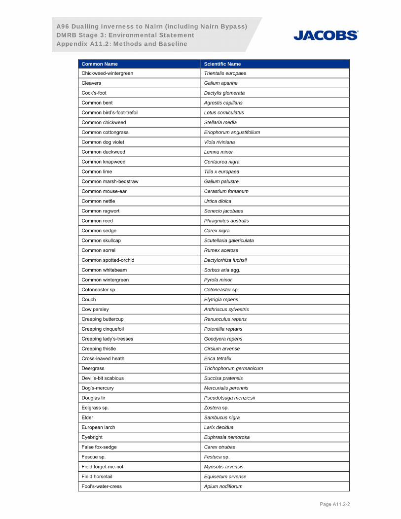
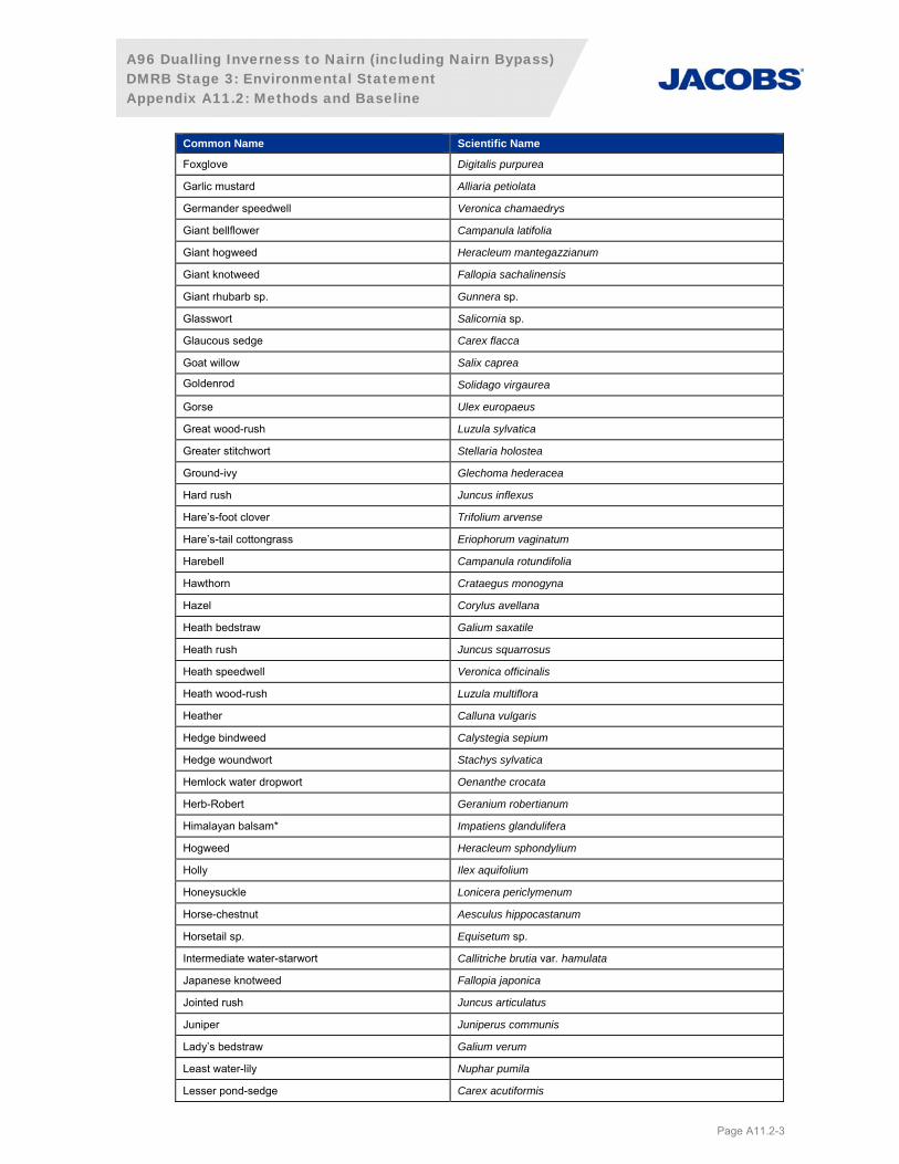
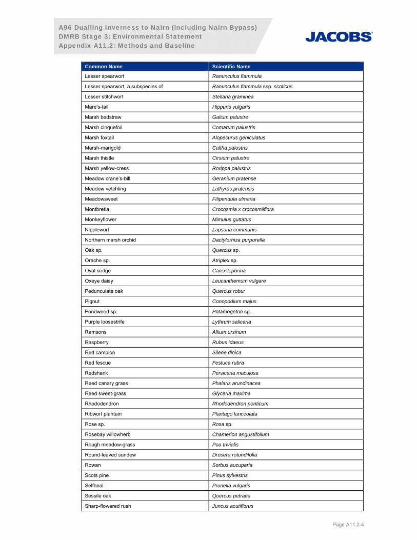
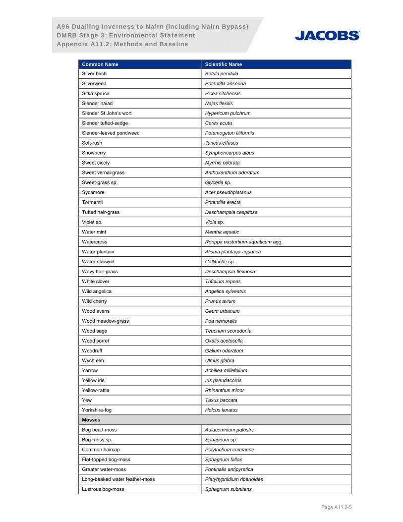
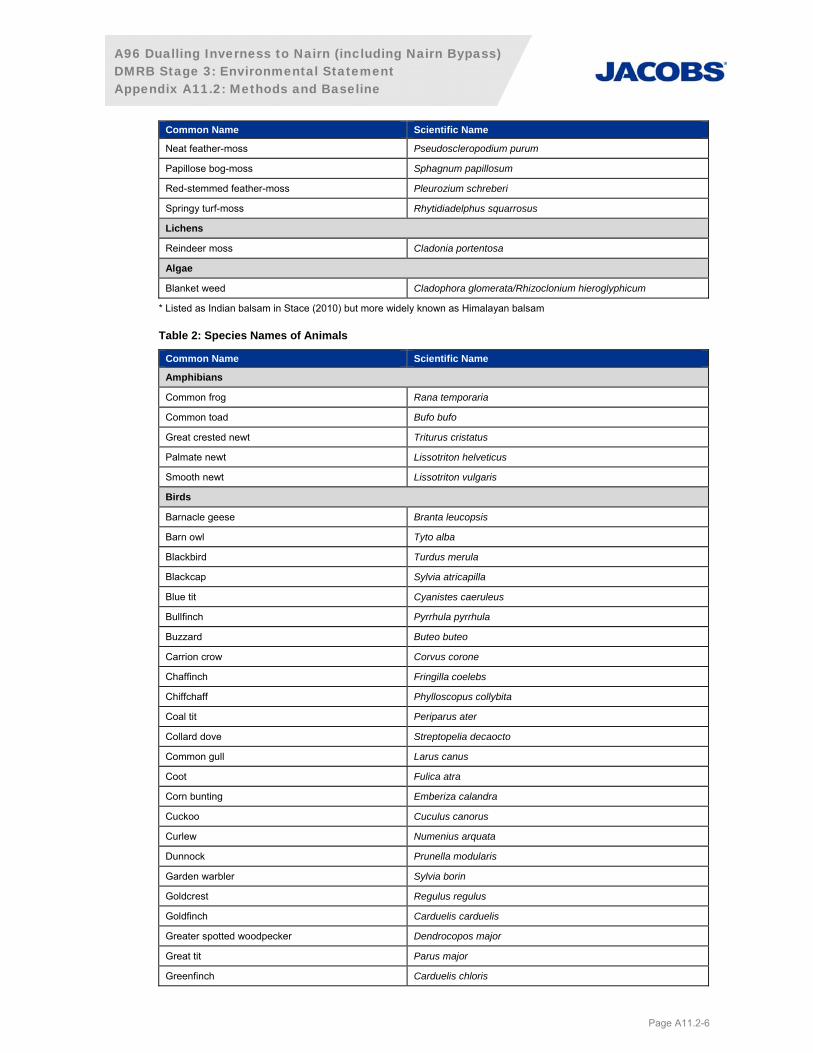
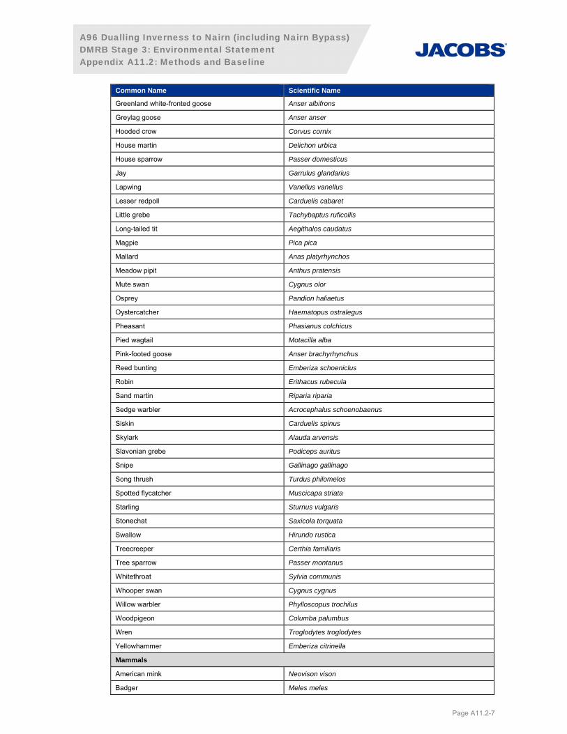
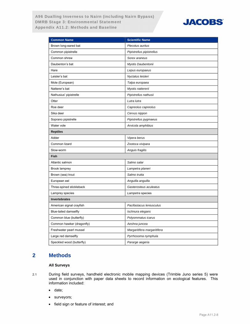

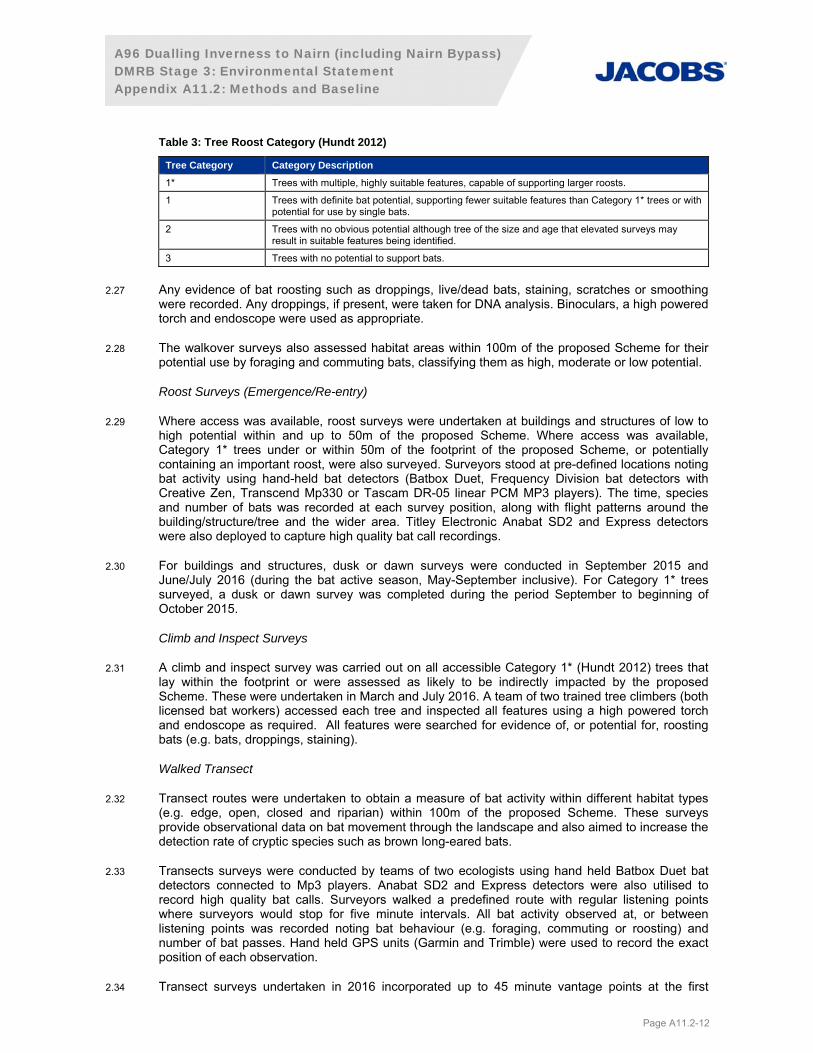

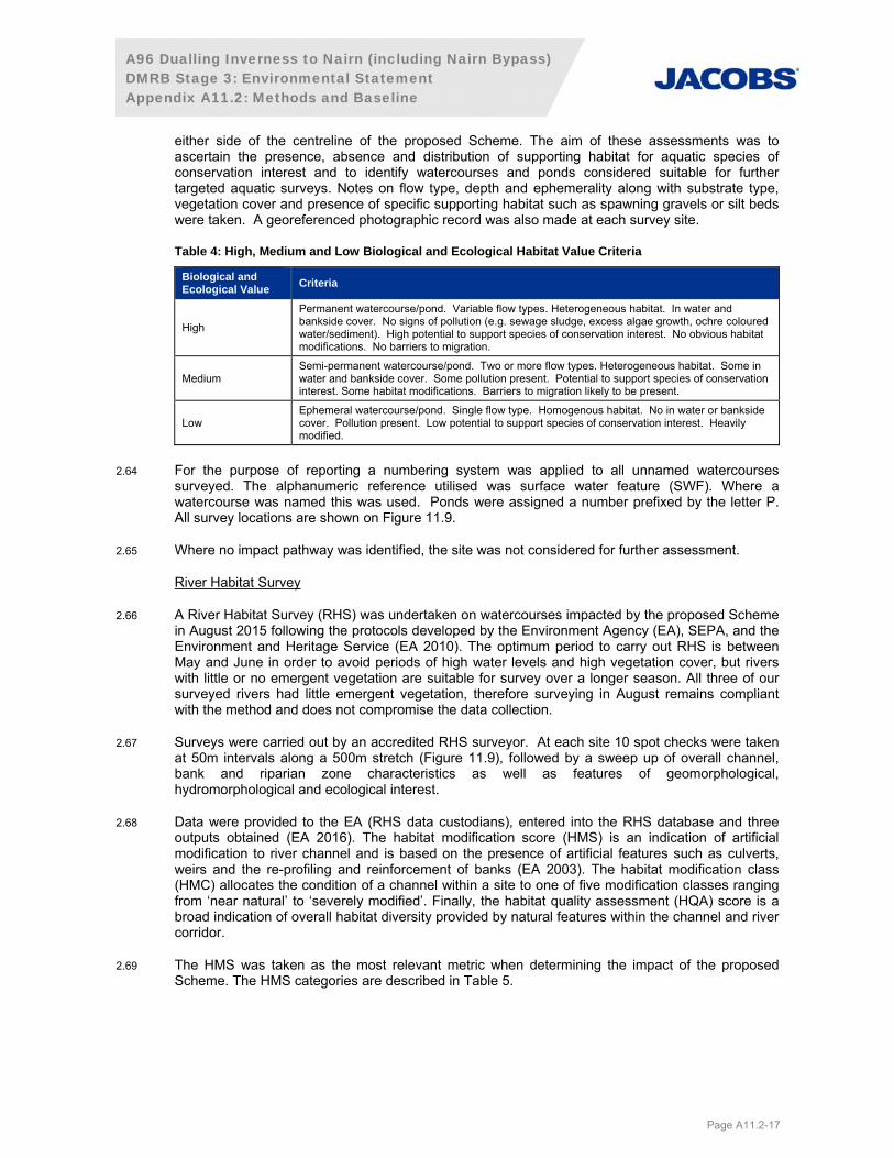
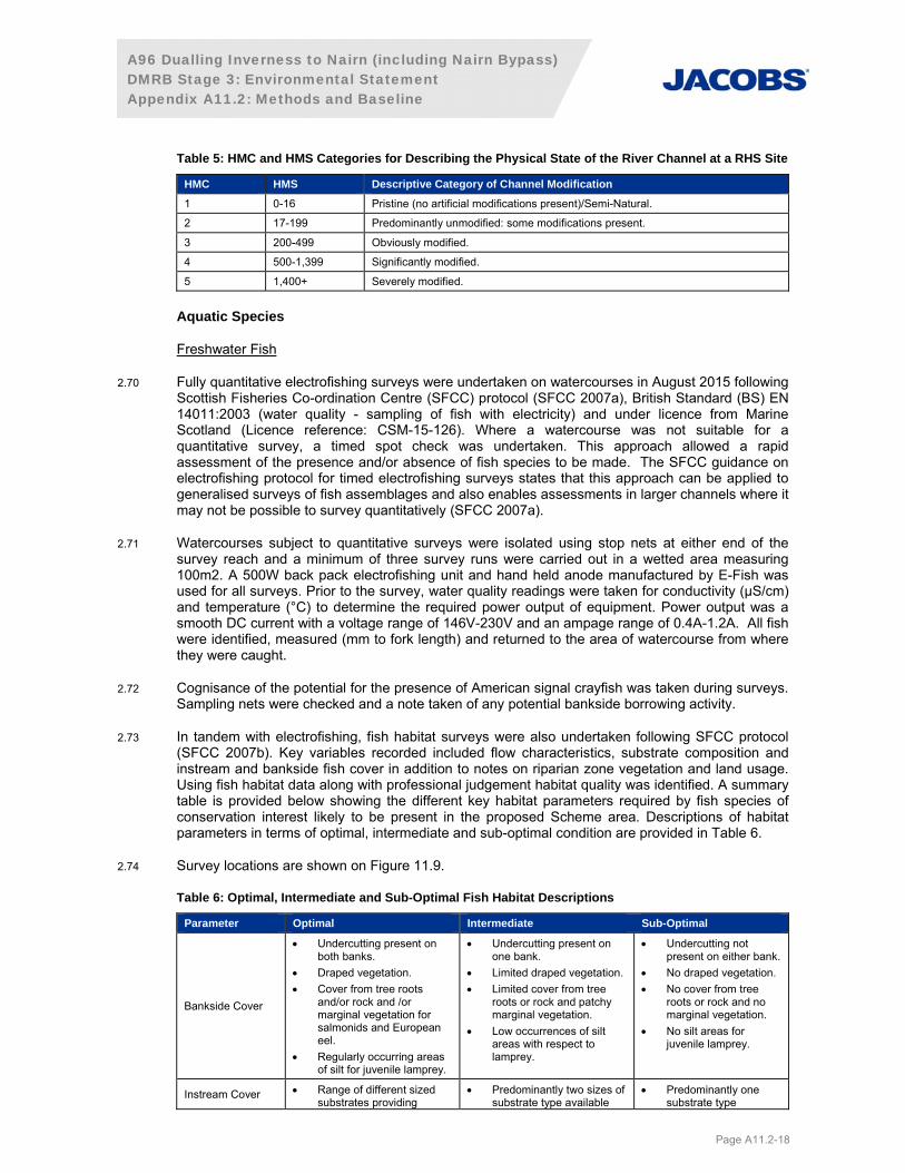
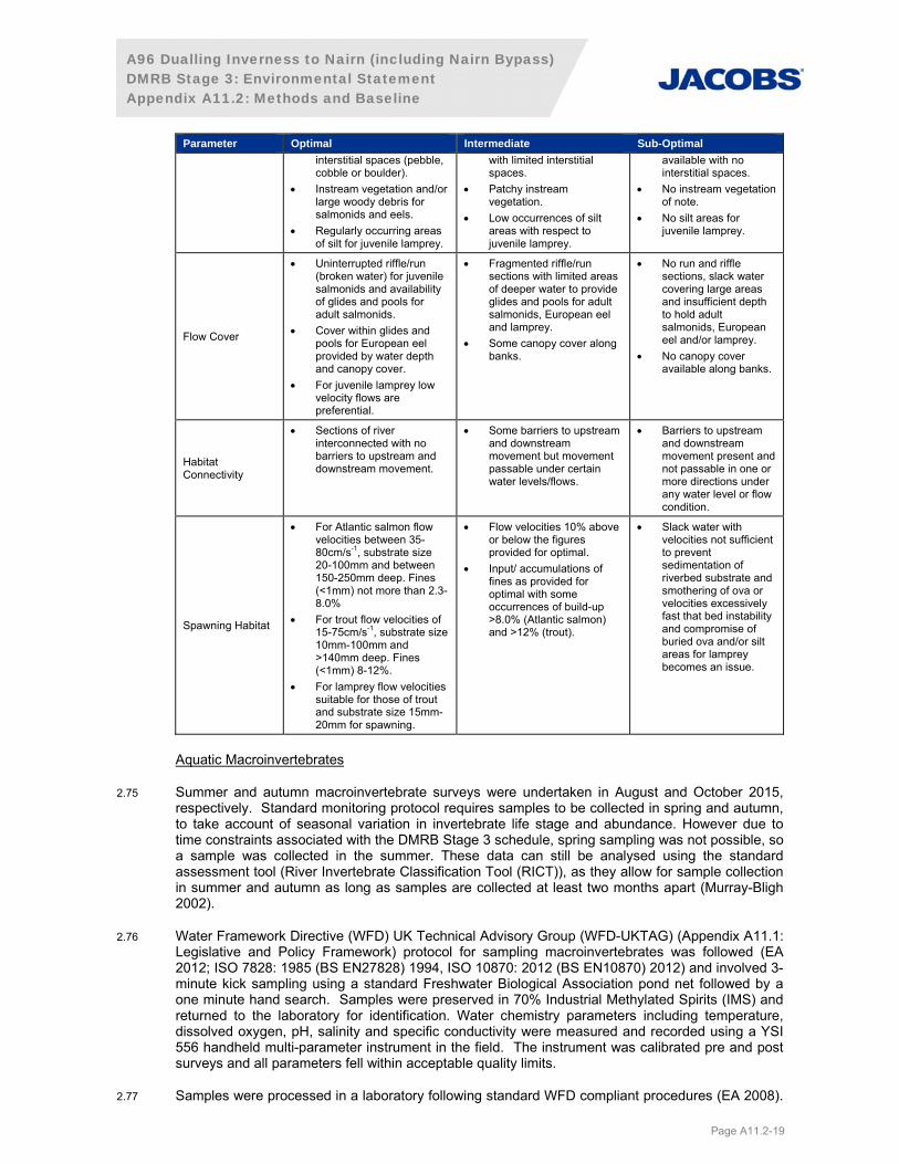
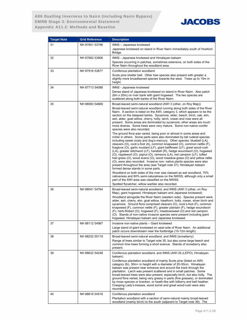
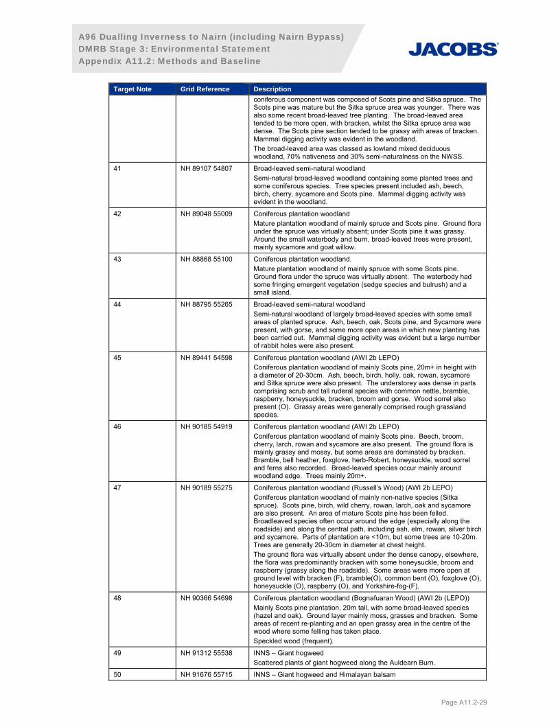
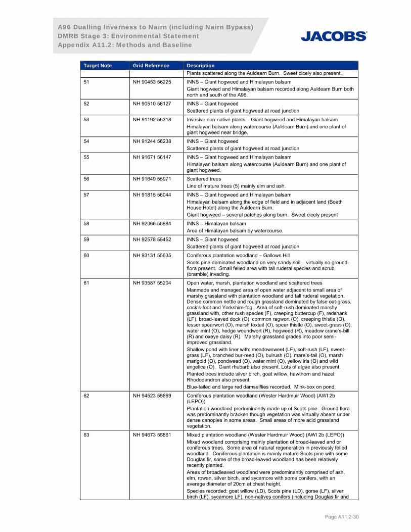
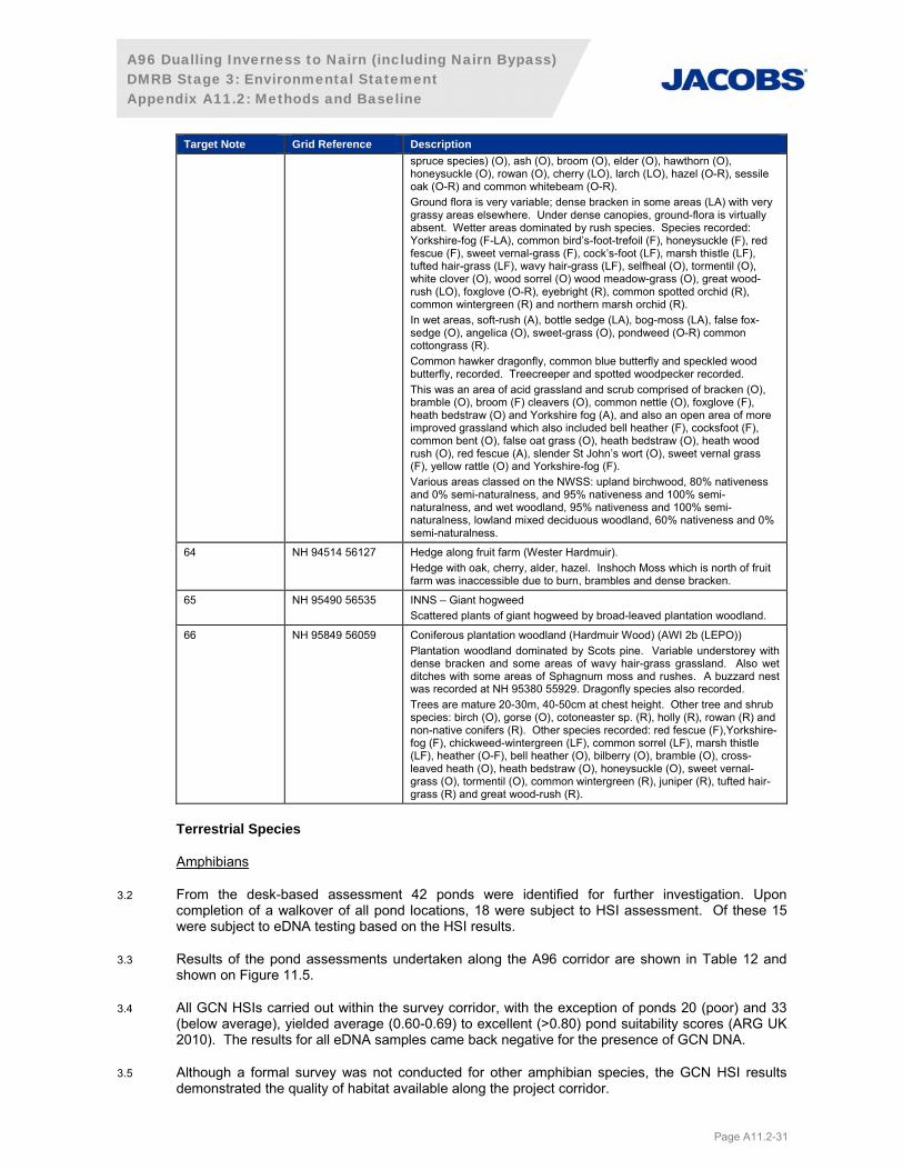
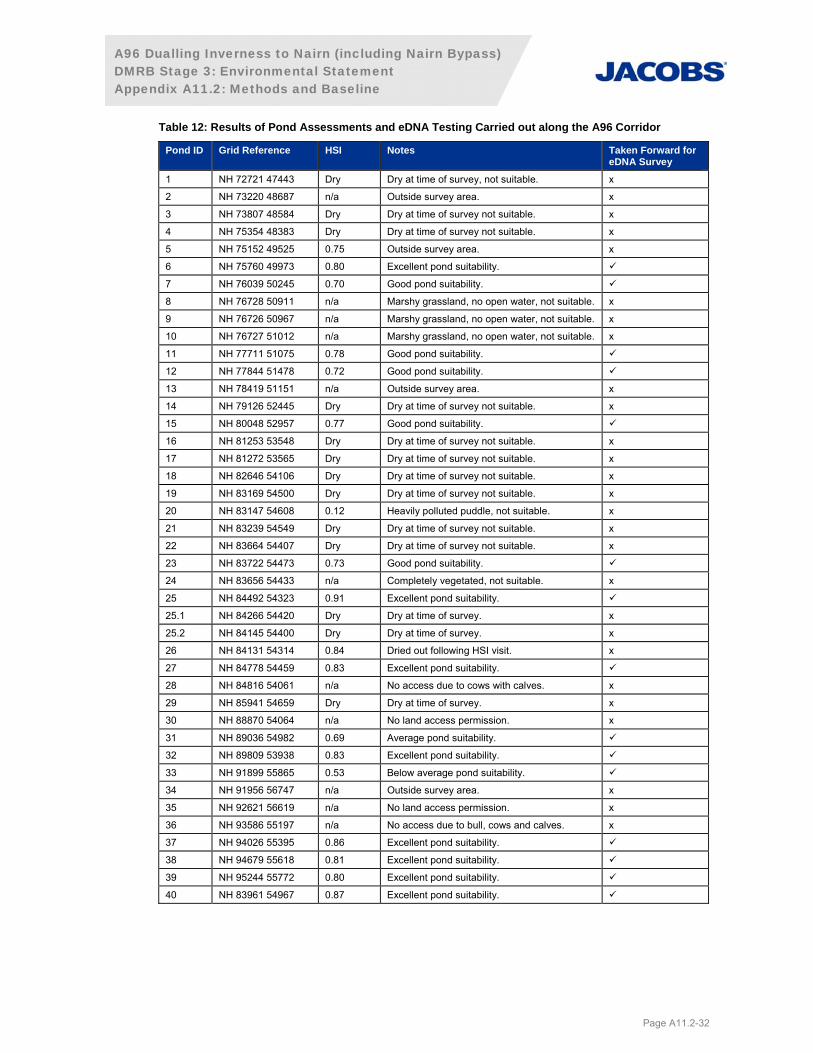
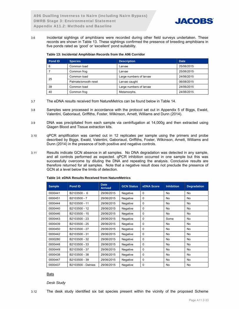
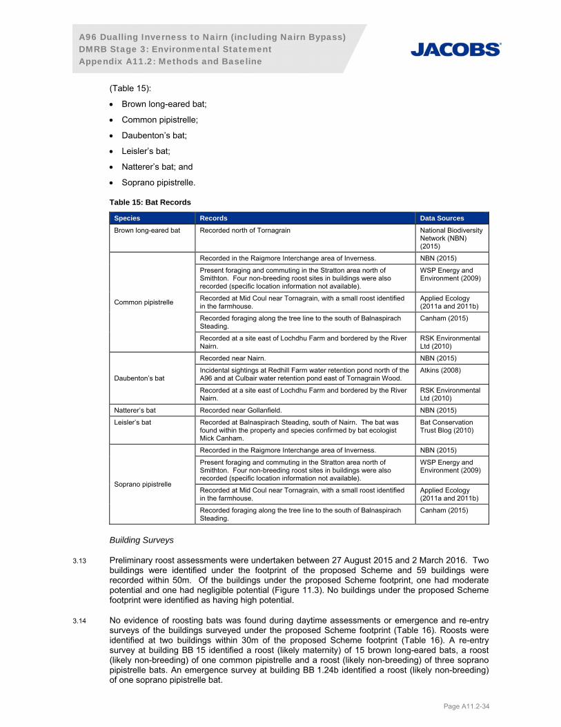
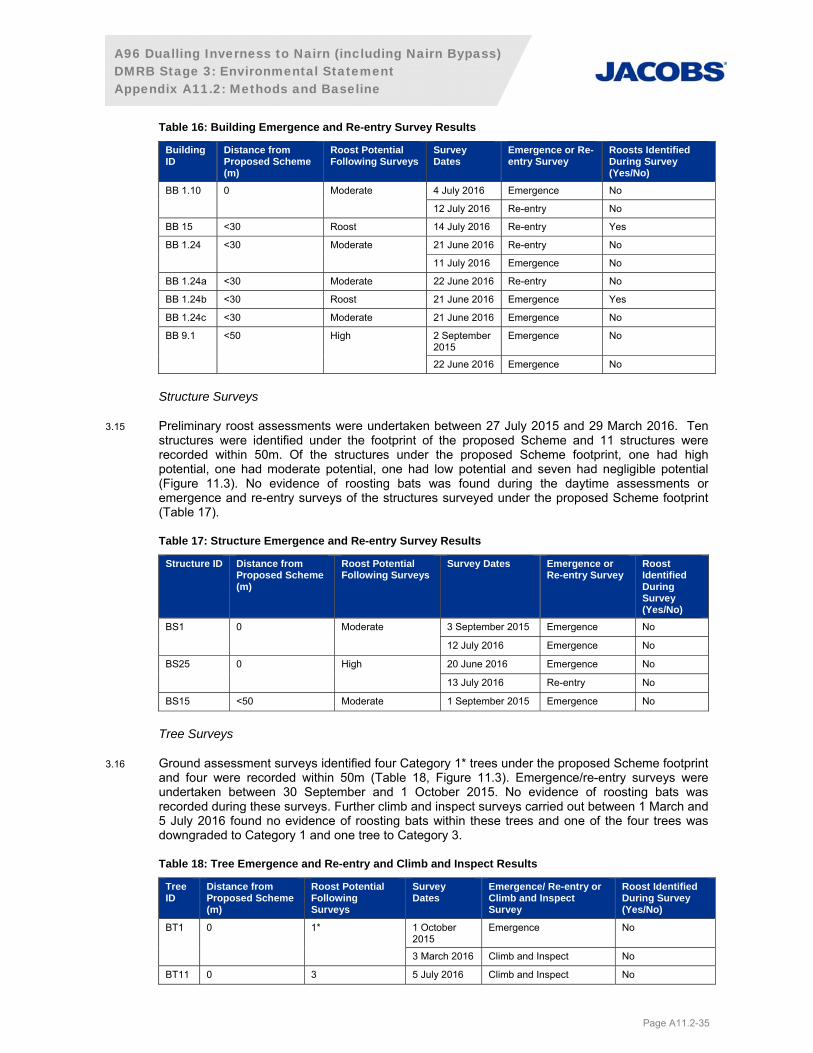
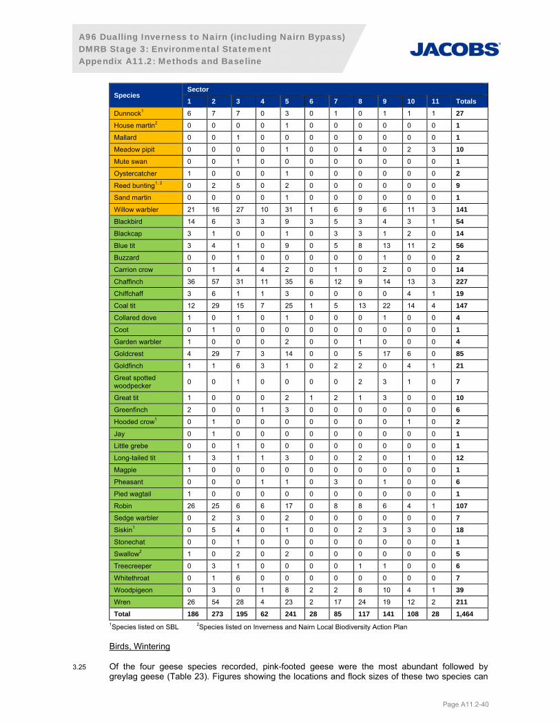
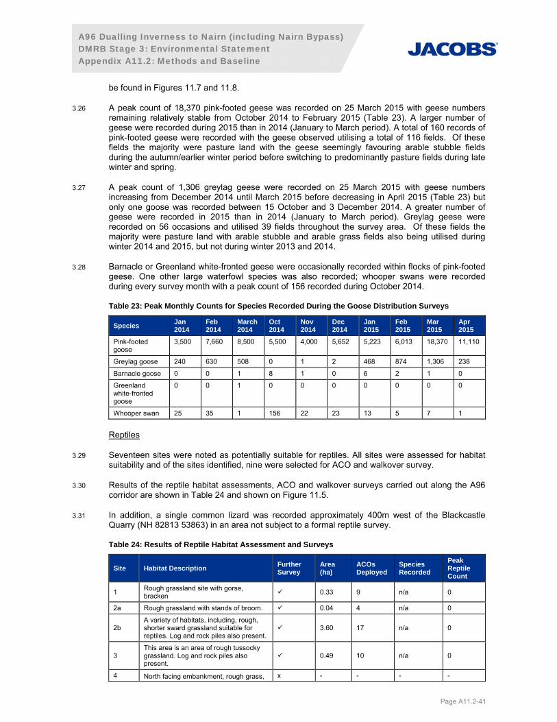
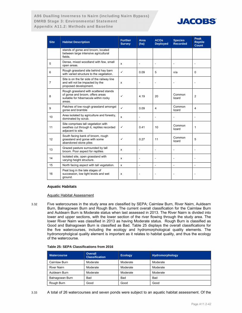
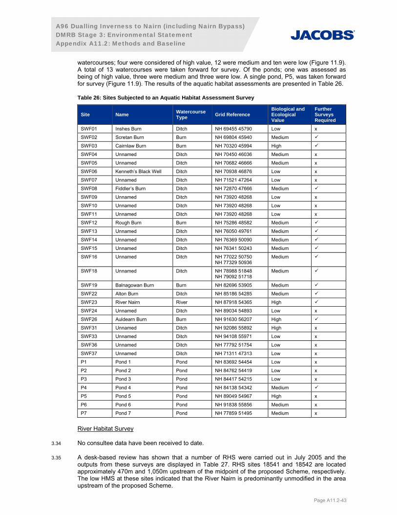
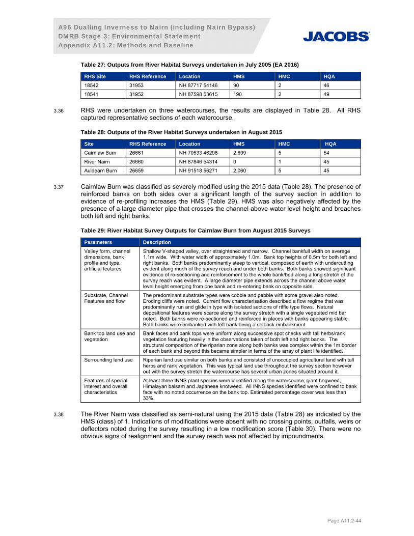
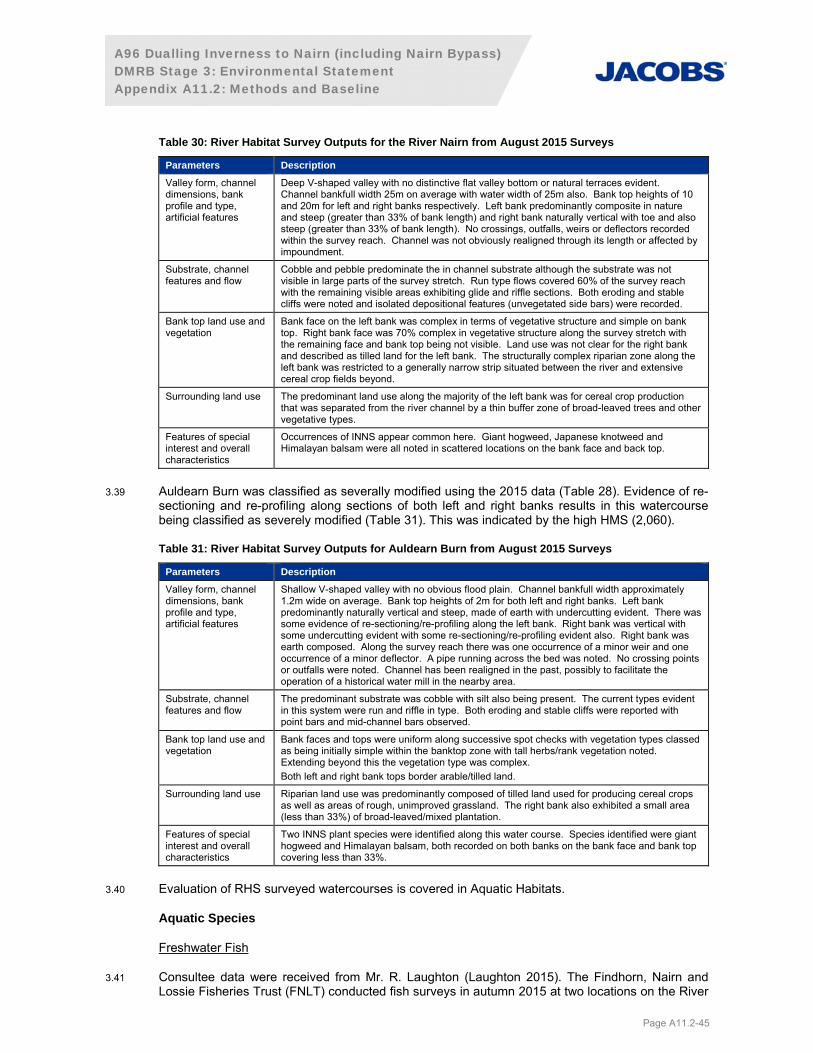
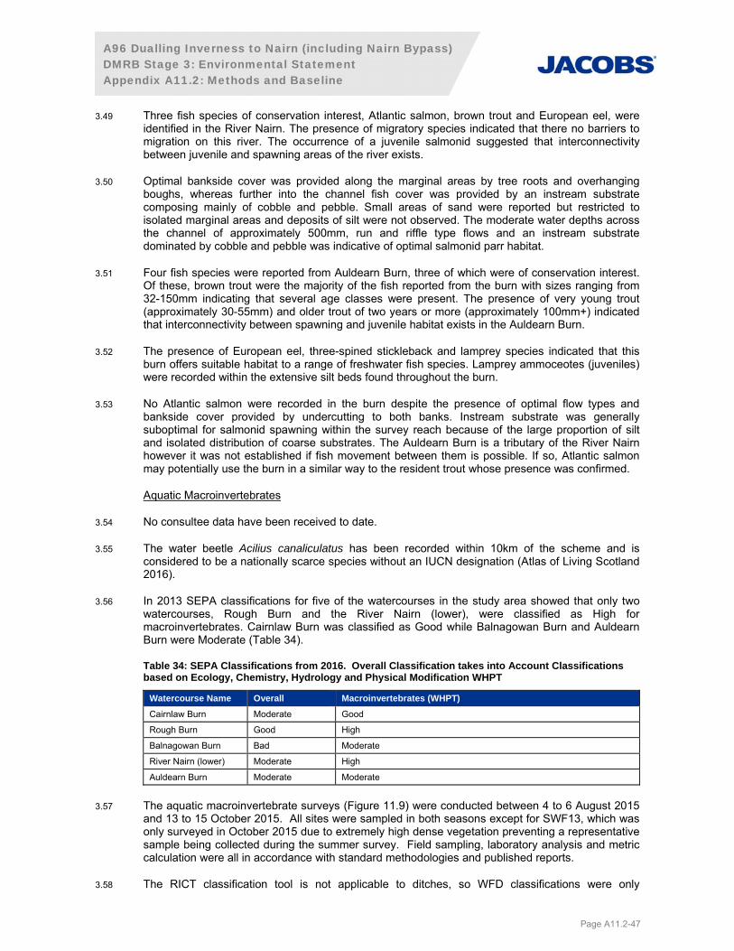
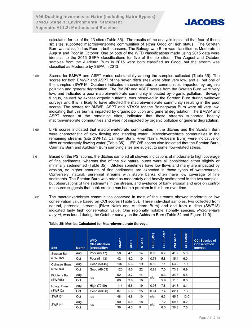
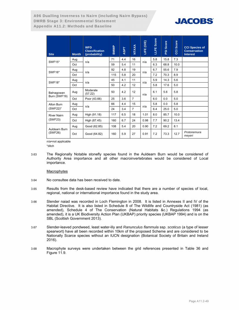
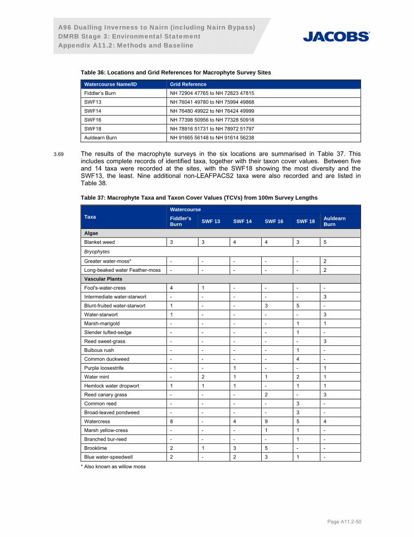
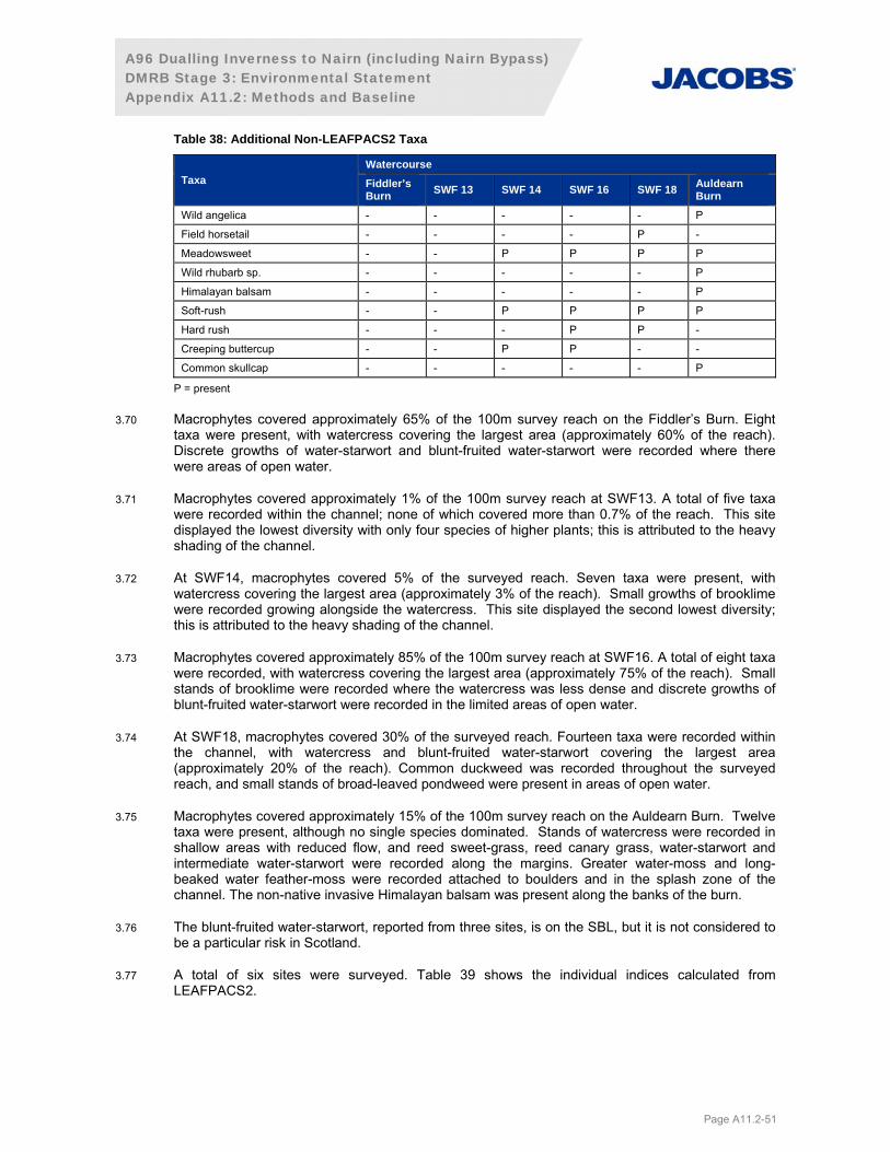
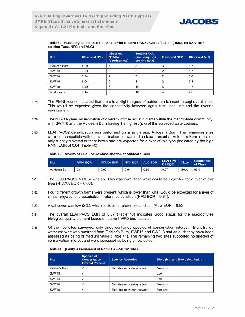
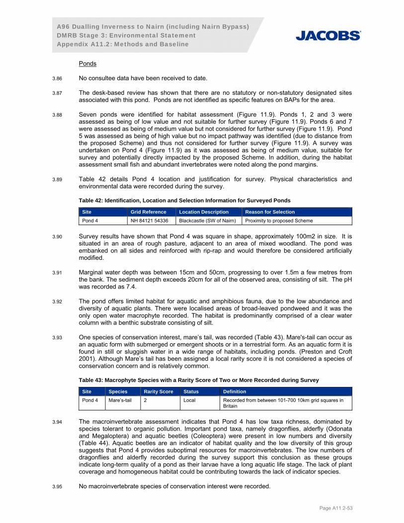


![Trace Element Accumulating Ability of Different Moss ... · Sphagnum sp. and Politrichum commune [55]; Sphagnum sp. in the Tomsk Region, the Volgograd Region and Siberia [47, 48];](https://static.documents.pub/doc/80x56/5cfab09488c993613f8d111d/trace-element-accumulating-ability-of-different-moss-sphagnum-sp-and-politrichum.jpg)