Northamptonshire Highways A45 Daventry Development Link Road Due for completion spring/summer 2018 Newsletter 6 - January 2018 Welcome to the sixth edition of the Daventry Development Link Road Newsletter. Happy New Year and we hope you had a good Christmas. Our first newsletter was issued in Spring 2016, and since then we have issued newsletters at fairly regular intervals. We want this newsletter – and subsequent issues – to keep you informed. We would also welcome your views and comments so that we can make sure we are giving you the information you really want. We will continue to build-up a ‘Frequently Asked Question’ (FAQ) section on the Northamptonshire County Council (NCC) website. If you are unsure about anything or want to know more please ask us. This will help to form the FAQ section on the NCC website and help to keep the information we provide to you relevant and accurate. This newsletter is produced by the delivery team for the project who are Northamptonshire Highways and Balfour Beatty Construction Services UK who are now well into the programme to build the new A45 Daventry Development Link Road. We will continue to issue these newsletters as we progress to keep residents, affected land owners, local businesses and other interested groups informed about our work and the way we will carry it out. Simon Levell Site liaison manager [email protected]Rebecca Miller Communication manager [email protected]The scheme The main works contract for the A45 Daventry Development Link Road has now been running for almost 18 months, and during this time considerable progress has been made on most aspects forming part of the overall scheme. Following the advance works (Phase 1 contract), which began early in 2016, entailing initial site clearance of vegetation, trees, hedges etc and establishment of boundary fencing – Balfour Beatty Civil Engineering were awarded the main works (Phase 2 contract) for the new road in July 2016. The progress on site can be summarised as follows: Earthworks Major progress has been made with the critical bulk earthworks operation which is now largely complete across much of the site. This includes excavation for cuttings, some of it in hard ground, to the north of Flore and the operation of placing this excavated fill material to form major embankments north of Weedon, including those leading up to the key railway and canal crossing near Dodford, the river crossing of the Whilton Brook north of Weedon and a new raised alignment for the A5 trunk road. Significant excavation has taken place to form cuttings in the vicinity of the Hillside Road bridleway, Brockhall Road and Brington Road areas immediately north of Flore. Progress has also been very good on excavation to the east of Flore towards Upper Heyford and the building of embankments around the Hollandstone Brook watercourse between the two villages. Further east, near M1 Junction 16, work is now well-advanced on the bulk earthworks for the proposed eastern termination roundabout and associated connecting tie-ins to existing roads and accesses.
Transcript
Northamptonshire HighwaysA45 Daventry Development Link RoadDue for completion spring/summer 2018Newsletter 6 - January 2018
Welcome to the sixth edition of the Daventry Development Link Road Newsletter. Happy New Year and we hope you had a good Christmas.
Our first newsletter was issued in Spring 2016, and since then we have issued newsletters at fairly regular intervals. We want this newsletter – and subsequent issues – to keep you informed.
We would also welcome your views and comments so that we can make sure we are giving you the information you really want.
We will continue to build-up a ‘Frequently Asked Question’ (FAQ) section on the Northamptonshire County Council (NCC) website. If you are unsure about anything or want to know more please ask us. This will help to form the FAQ section on the NCC website and help to keep the information we provide to you relevant and accurate.
This newsletter is produced by the delivery team for the project who are Northamptonshire Highways and Balfour Beatty Construction Services UK who are now well into the programme to build the new A45 Daventry Development Link Road.
We will continue to issue these newsletters as we progress to keep residents, affected land owners, local businesses and other interested groups informed about our work and the way we will carry it out.
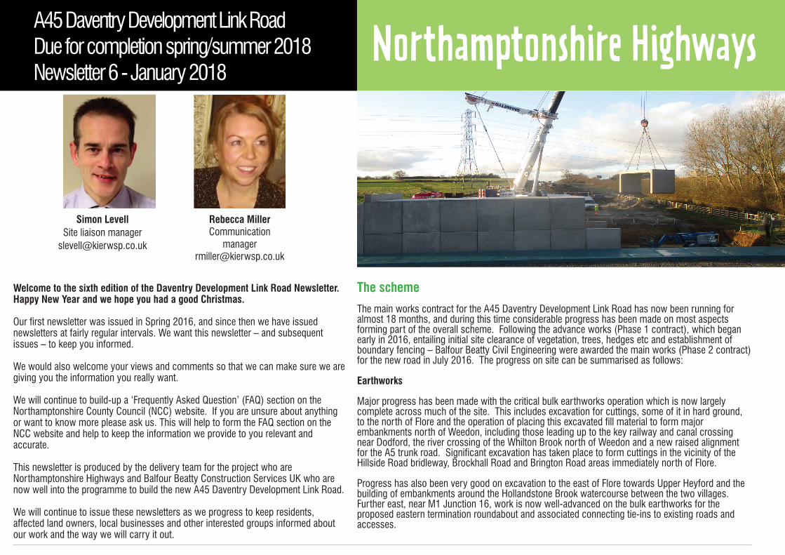
The main works contract for the A45 Daventry Development Link Road has now been running for almost 18 months, and during this time considerable progress has been made on most aspects forming part of the overall scheme. Following the advance works (Phase 1 contract), which began early in 2016, entailing initial site clearance of vegetation, trees, hedges etc and establishment of boundary fencing – Balfour Beatty Civil Engineering were awarded the main works (Phase 2 contract) for the new road in July 2016. The progress on site can be summarised as follows:
Earthworks
Major progress has been made with the critical bulk earthworks operation which is now largely complete across much of the site. This includes excavation for cuttings, some of it in hard ground, to the north of Flore and the operation of placing this excavated fill material to form major embankments north of Weedon, including those leading up to the key railway and canal crossing near Dodford, the river crossing of the Whilton Brook north of Weedon and a new raised alignment for the A5 trunk road. Significant excavation has taken place to form cuttings in the vicinity of the Hillside Road bridleway, Brockhall Road and Brington Road areas immediately north of Flore.
Progress has also been very good on excavation to the east of Flore towards Upper Heyford and the building of embankments around the Hollandstone Brook watercourse between the two villages. Further east, near M1 Junction 16, work is now well-advanced on the bulk earthworks for the proposed eastern termination roundabout and associated connecting tie-ins to existing roads and accesses.
In addition, the more advanced areas of earthworks are now receiving layers of crushed stone (the base layer prior to actual tarmacking) and associated kerbing ready for the new carriageway. Meanwhile, new landscape amenity screening embankments – or bunds – have been, or are being placed, to the north of Flore village (section between Brington and Brockhall Roads) and north of Hillside Road.
Drainage
Highway drainage systems continue to be laid in several locations along the site, which are critical to ensuring the eventual surfaced carriageway is able to freely drain surface water during periods of rainfall and the earthworks themselves are properly drained of percolating groundwater so they remain stable.
In terms of the drainage works, carriageway drainage pipes, kerb gullies and connecting manhole chambers have now been completed or are being placed along many parts of the site, major progress having been made during the last few months between the Whilton Brook crossing and Hillside Road, between Hollandstone Brook and Upper Heyford and around the new eastern roundabout near M1 Junction 16. The main areas remaining to be completed are west of the A5 and in the vicinity of several of the structures.
Three balancing ponds out of a planned total of five are now complete, the most recent being created within the ‘island’ of the new eastern roundabout: These ponds are areas designed to retain surface water from the new road during periods of heavy rainfall so it can be released into the river system at a controlled rate.
UtilitiesDiversion and protection of underground and overhead services has been taking place at critical locations across the site since works began.
This includes (but is not limited to) undergrounding of two high voltage overhead electric cables next to the railway and canal near Dodford (so as not to interfere with the major bridge and embankment construction in the area), gas main and telecom works at the western termination roundabout, the A5 and near M1 Junction 16, and several water mains where the route crosses public roads as well as trunk mains that lay in the path of the new road. Two electricity sub-stations and associated feeder connections east of Upper Heyford, which lay directly in the path of the new link road, have now been successfully relocated, and overall much of the fundamental utilities works are complete.
Accommodation worksAccommodation works associated with local land owners have continued steadily. These ensure farming operations can continue to take place effectively both during and after the works, and a number of new field gates have been installed to facilitate access to severed agricultural land, and a series of water troughs have been installed to provide drinking water for livestock. The programme of water trough installation is largely complete, including water supply feeder pipes. Further farm tracks and stock handling fencing areas have yet to be completed, along with replacement access crossings from public roads into fields where local roads crossing the link road are being altered or diverted in some way, such as the Brockhall and Brington Roads near Flore and the byway road at Upper Heyford.
StructuresThe Daventry Link Road scheme is characterised by a number of structures, given the constraints imposed by local roads / rights of way, watercourses and other transport corridors which intersect the route.
Brockhall Road Bridge – which carries Brockhall Road over the link road – this bridge is now complete and the local road it serves was re-opened to the public in mid-September (on a slightly re-aligned course to its original route) after a closure which began in January to facilitate bridge construction. This is the most advanced structure on the scheme, and to enable it to be opened for public use, the earthworks and drainage leading up to the bridge, road surfacing and safety barrier installation have also been completed.
Brington Road Bridge – like Brockhall Road, Brington Road is another key local road, north of Flore, which is to be carried over the new link road via a bridge, mirroring the nearby bridges over the M1 motorway just to the north. Works started on this structure shortly after the Brockhall Road re-opened in mid-September, as it is a condition of the construction contract that both roads could not be shut at the same time. Following major excavation to form the cutting in which the bridge will sit, works began on the bridge in October, with the two abutment walls (bridge supports) on either side progressing well. The Brington Road closure is due to last around 6-7 months, with signed diversions in place for local traffic until opening in the Spring.
Green Bridge – this is the second most advanced structure on the scheme, and apart from finishing works it is now largely complete: Approach embankment ramps have been constructed on either side and a stone track laid, with tarmac surfacing over the actual bridge. This bridge carries a bridleway north of Flore (extension of Hillside Road) as well as providing local agricultural access. It is also being provided for ecological purposes to provide a wildlife corridor for bats and various other mammals, owing to severance of habitat by the new road, hence it being titled “Green Bridge”.
We aim to minimise disruption for our neighbours during construction.
We will do this by:
• Carrying out as much of the construction work during the day time as we can• Using clear diversion route signs when roads are closed• Ensuring that site vehicles only use approved routes• Closely monitoring the impact of site operations• Using techniques and machines designed to minimise noise and vibration• Keeping in regular contact with our neighbours so they are informed as works progress
For road users we will ensure their safety by:
• Operating a reduced speed limit through the road works; this makes it safer for the workforce and drivers, and gives drivers more time to react to the road conditions ahead • Keeping road closures to a minimum and avoiding peak hours where possible
Upper Heyford Bridge – This farm access bridge at Upper Heyford is well advanced, the beams have been placed and the reinforced concrete deck completed, along with the aluminium parapets along both sides of the span. Whilst there is still some more work to do, when complete the bridge will provide continuity of the local byway road as well as providing essential agricultural access.
Whilton Brook Bridge - A key bridge over a tributary of the River Nene is also progressing well. The Whilton Brook Bridge has a particularly large span to meet criteria associated with minimising the effect on the flood plain. Following placing of eight precast concrete beams in the Summer, works continued to complete the bridge deck and parapets during the Autumn, and the most recent works have been concrete wing walls (extensions of the bridge approaches) on either side of the river.
Hollandstone Farm Culverts – These structures have now started and are progressing well. Over the last couple of months, there have been two visits to site by a large mobile crane to lift first a series of precast box units to span the Hollandstone Brook watercourse (midway between Flore and Upper Heyford) and subsequently a number of even larger precast concrete sections to form a farm access subway under the link road embankment. There is a further structure yet to be built in this area, and several associated works in and around the culverts to take place before they are fit-for-purpose.
Dodmoor Rail & Canal Bridge – Last but not least is the critical and largest structure on the entire scheme – the Dodmoor Rail & Canal Bridge. This major two-span bridge will eventually carry the link road over the West Coast Main Line Railway and Grand Union Canal. All piling works are now complete on both sides of the bridge and in the centre, and the focus of construction has now switched to building the massive abutment walls to support the embankments on both the canal and railway approaches, columns to support the bridge beams, and notably a central pier (intermediate support) for the bridge literally ‘sandwiched’ between the railway and canal. Major construction challenges lay ahead for this bridge as a whole – including overnight operations at weekends when Network Rail temporarily closes the railway to allow works to proceed.
A5 Trunk Road:Another major milestone was met in November, with the re-opening of the A5 trunk road, north of Weedon, following its reconstruction at a higher level than originally to intercept the new link road via a roundabout. This has enabled the closure of the temporary diversion road just to the west which has been in use for about a year, the removal of which is necessary to complete critical earthworks and drainage works, the major bridge over the canal/railway, and reinstate land that has been rented from adjacent land owners.
SummaryOverall, the scheme is progressing well, although the shorter daylight hours of Autumn into Winter, coupled with recent challenging weather associated with heavy snowfall and freezing conditions has created significant challenges for construction activities in recent weeks.
Community Liaison & Communications: Throughout these works, close liaison continues to be maintained with the local land owners, in order to ensure that their farming operations are not compromised or otherwise delayed in relation to the construction operation. Close and amicable relationships are also being maintained with local residents, businesses, parish councils and statutory bodies, collectively ensuring that the works can co-exist whilst minimising disruption and community-related issues.
In this latter respect, a Community Stakeholder Working Group has been set-up, and has already met on a number of occasions to discuss issues relating to the impact of the scheme on the local community, and to address issues before they become problems. Furthermore, Balfour Beatty have registered the project with the Considerate Constructors Scheme, a nationally-recognised initiative which rewards contractors and projects based on being good neighbours with the local residential, business and road-using communities with whom they have to co-exist. Balfour Beatty have contributed to several community initiatives in both Weedon and Flore, whilst links with local schools in terms of safety awareness and careers ideas bring a further community dimension.
This quarterly Newsletter continues to be issued to those who wish to sign-up to the e-mailing distribution list.
For more information about the scheme you can visit the website at www.northamptonshire.gov.uk
Please advise people that they can join this mailing list and receive regular progress updates by emailing [email protected] and registering their email address. They will be added to the mailing list and this information will remain confidential and will not be shared with any third parties.
If you have any questions relating to these activities please do not hesitate to contact Simon Levell at [email protected] who will be your site-based contact on day-to-day issues specifically relating to the road construction phase and its impacts.
For all general highway issues that are not specific to the Daventry Development Link Road works you should contact the Street Doctor service in Northamptonshire.
Remember, you can also report highway faults online too at northamptonshire.gov.uk/streetdoctor
Follow us on Twitter @nnhighways for all the latest transport and highways updates and news.
A45 Daventry Development Link Road funded by:Northamptonshire County Council, SEMLEP and


![High Court Judgment Template€¦ · Web viewThis was the approach taken by the Court of Appeal in Daventry DC v Daventry District Housing Ltd [2012] 1 WLR 1333 (“Daventry”) albeit](https://static.documents.pub/doc/80x56/5fe2796db0258947166afa02/high-court-judgment-template-web-view-this-was-the-approach-taken-by-the-court-of.jpg)


