- 1 - Aberdeen Road Diet – Community Task Force Report November 2015 The Kirkendall Neighbourhood Association, in conjunction with a number of committed volunteers and community members, welcomes and is thankful for the opportunity to provide input on improvements to Aberdeen Avenue (Queen St. to Longwood Rd.). This was identified as a “Top 5” project in Ward 1’s most recent Participatory Budgeting process. Our concerns and recommendations are outlined below. We hope that changes to Aberdeen will result in a street that functions well for a multitude of different users in our community. Introduction Aberdeen carries 18,000 vehicles per day. In its current configuration, it does not function well for pedestrians, cyclists, or proximate homeowners. It is perceived as (and functions as) a dangerous, intimidating and unpleasant street for non-motorists. For motorists, it can also be dangerous because the current design has led to increased speeding on the street, which is a contributing factor in traffic collisions and fatalities. This design has the effect of discouraging cycling and walking in an otherwise multimodal and vibrant neighbourhood. However, Aberdeen is an unavoidable route for those who do choose to cycle and walk. Aberdeen is the only route to Westdale south of King and among others, it is used by an estimated 234 children per day on their way to and from Westdale Secondary School. 1 This combination makes Aberdeen uniquely problematic, out of place in the neighbourhood, and in need of positive change. A road diet entails re-working a busy street to calm traffic and make the street more “Complete” involving more welcoming opportunities to cycle, walk and use public transit. 2 It is our recommendation that the City promptly institute measures that will result in: ● Slower vehicle traffic with similar roadway capacity; ● Enhanced safety and improved walkability for pedestrians (real and perceived); ● Cycling infrastructure that either safely and intuitively re-directs cyclists off Aberdeen at suitable intersections, or continues in a protected manner the full distance of the street. ● Minimal (if any) losses in on-street parking. 1 According to the Hamilton Wentworth District School Board, there are 756 students within the “Walking Boundary” for Westdale Secondary School and 234 of those are estimated to walk to and from school on a daily basis from the Kirkendall Neighbourhood (ie. East of Longwood). 2 For example, The Federal Highway Administration in the U.S. advises that roadways carrying less than 20,000 vehicles per day on four lanes may be suitable for a reduction in lanes or a “road diet.” See: http://safety.fhwa.dot.gov/road_diets/info_guide/
Transcript
- 1 -
Aberdeen Road Diet – Community Task Force Report November 2015
The Kirkendall Neighbourhood Association, in conjunction with a number of committed volunteers and community members, welcomes and is thankful for the opportunity to provide input on improvements to Aberdeen Avenue (Queen St. to Longwood Rd.). This was identified as a “Top 5” project in Ward 1’s most recent Participatory Budgeting process. Our concerns and recommendations are outlined below. We hope that changes to Aberdeen will result in a street that functions well for a multitude of different users in our community. Introduction Aberdeen carries 18,000 vehicles per day. In its current configuration, it does not function well for pedestrians, cyclists, or proximate homeowners. It is perceived as (and functions as) a dangerous, intimidating and unpleasant street for non-motorists. For motorists, it can also be dangerous because the current design has led to increased speeding on the street, which is a contributing factor in traffic collisions and fatalities. This design has the effect of discouraging cycling and walking in an otherwise multimodal and vibrant neighbourhood. However, Aberdeen is an unavoidable route for those who do choose to cycle and walk. Aberdeen is the only route to Westdale south of King and among others, it is used by an estimated 234 children per day on their way to and from Westdale Secondary School.1 This combination makes Aberdeen uniquely problematic, out of place in the neighbourhood, and in need of positive change. A road diet entails re-working a busy street to calm traffic and make the street more “Complete” involving more welcoming opportunities to cycle, walk and use public transit.2 It is our recommendation that the City promptly institute measures that will result in:
● Slower vehicle traffic with similar roadway capacity; ● Enhanced safety and improved walkability for pedestrians (real and
perceived); ● Cycling infrastructure that either safely and intuitively re-directs cyclists off
Aberdeen at suitable intersections, or continues in a protected manner the full distance of the street.
● Minimal (if any) losses in on-street parking.
1 According to the Hamilton Wentworth District School Board, there are 756 students within the “Walking Boundary” for Westdale Secondary School and 234 of those are estimated to walk to and from school on a daily basis from the Kirkendall Neighbourhood (ie. East of Longwood). 2 For example, The Federal Highway Administration in the U.S. advises that roadways carrying less than 20,000 vehicles per day on four lanes may be suitable for a reduction in lanes or a “road diet.” See: http://safety.fhwa.dot.gov/road_diets/info_guide/
- 2 -
Specific Concerns Below we present some of our primary concerns with the current configuration of Aberdeen and some recommended solutions and proposals. We do not claim to offer planning or traffic expertise, but we do offer expertise as to the community’s experience. We also do not claim to address all the complex variables that obviously factor in to this multifaceted matter, rather we present the following to provide community insight and look forward to working constructively with the City’s expert staff as changes are finalized and implemented.
● Traffic Speed: The high speed of traffic means pedestrians and cyclists are less safe and feel vulnerable and unwelcome. It also means an increased likelihood of traffic accidents. Traffic speeds also increase noise as well as rain/slush splash which is bothersome to residents and further discourages walking and cycling. Solution: Proposals 1-5 below all involve narrower and fewer lanes, which will result in slower speeds while still allowing Aberdeen to function as a minor arterial road carrying, as it currently does, about 18,000 cars per day.
● Proximity of Traffic: Many segments of Aberdeen have narrow sidewalks with
no buffer between pedestrians and fast-moving traffic. This makes walking an intimidating and dangerous experience – especially for seniors, children, people with disabilities and dog-walkers. Of particular concern is the south side between Mountain and Undermount (See Appendix A). This is an especially high-traffic stretch for pedestrians heading to/from Locke Street and it is narrow and intimidating). Also of concern is the south side between Chedoke and Studholme and the north side between MacDonald and Longwood (See Appendix B). Solution: Proposals 1-5 below all employ parking and/or protected bike lanes as buffers between the sidewalk and street.
● Turning Radii at Cross Streets: (See Appendix C) Cross streets along
Aberdeen such as Mountain Avenue have wide turning radii which increase the speed at which cars can make the turn while also increasing the distance which pedestrians have to cross. Solution: Extend sidewalks to decrease turning radii at cross streets. Interim measure can employ knockdown sticks.
● Crossing at Dundurn: Regardless of the traffic light phase, this crosswalk does
not default to allow pedestrians to cross. Instead, the pedestrian signal is activated only by a push-button. This is a very active intersection with young children and parents walking to Earl Kitchener Elementary School. Also, at night, the signal only turns green if triggered by a vehicle (cyclists must dismount to push the button). Solution: Pedestrian signal should default to “cross” when traffic light phase permits. Alternatively, consider a pedestrian scramble. Consider installing sensors for the light to be actuated by a bicycle.
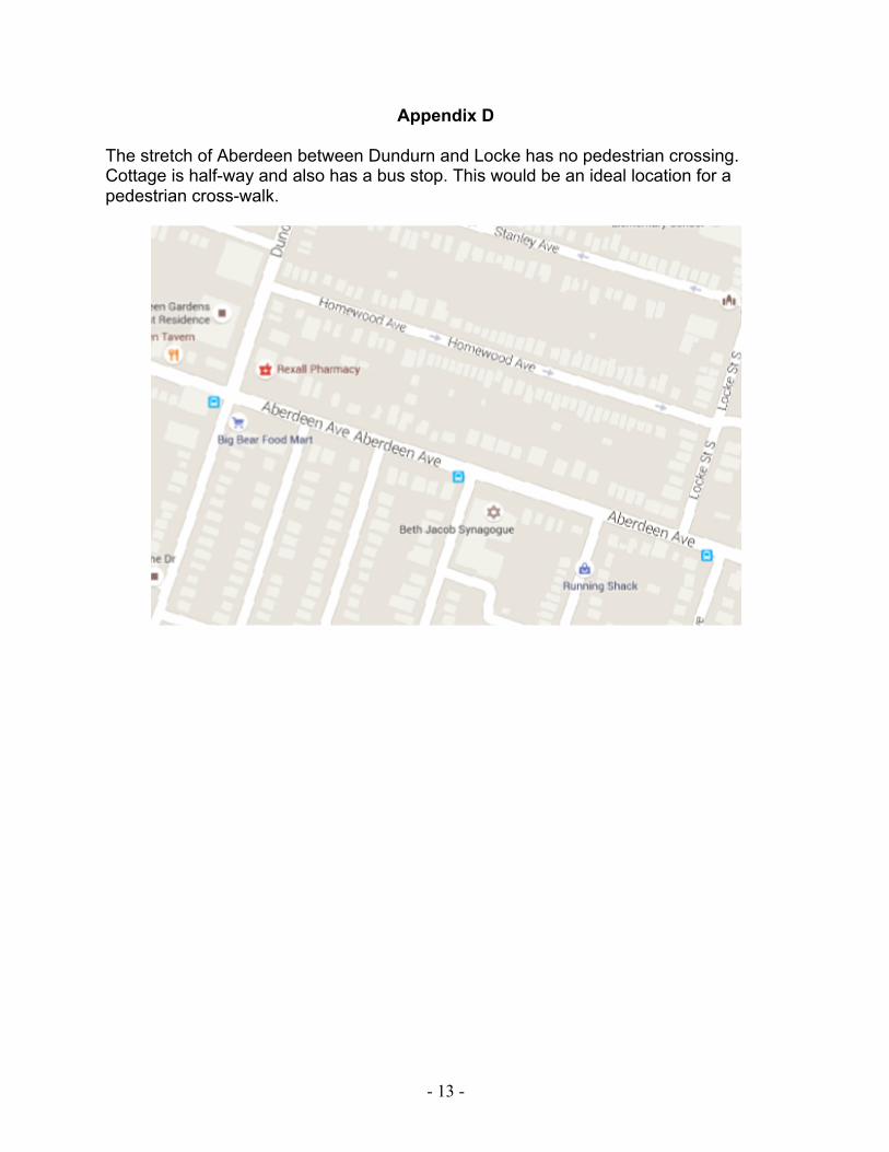
● No Pedestrian Crossing between Dundurn and Locke: (See Appendix D) This
is a long stretch with no crossing for pedestrians. In fact it is one of the longest
- 3 -
blocks in the City. There is a bus stop at Cottage furthering the demand for a safe crossing here. Solution: Install a pedestrian cross-walk at Cottage.
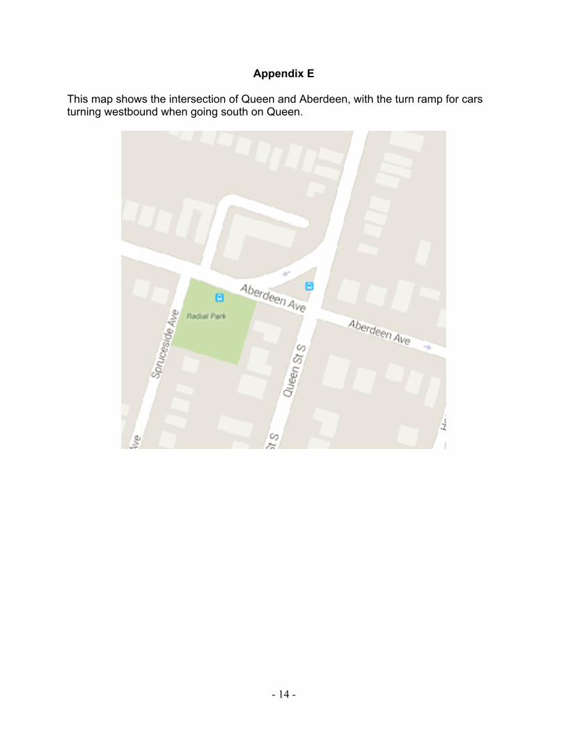
● Turn ramp at Queen and Aberdeen: (See Appendix E) Traffic heading south on
Queen, turning west onto Aberdeen is channeled, at high speeds, through a highway-style on-ramp which is difficult and hazardous for pedestrians to cross. Solution: We understand that a pedestrian crosswalk may be in the works at this location. It would also be helpful to use knock down sticks or planter boxes to narrow the ramp to the width of a standard travel lane (it is currently very wide). Ideally the ramp would be removed completely and south-bound traffic wishing to travel west would be routed to a regular right-turn at the light.
● Lack of Cycling Infrastructure: The lack of a shoulder or bike lane along the
majority of Aberdeen coupled with fast traffic make the street dangerous and unwelcoming for cyclists. Of particular concern are the following two areas:
● Eastbound around Hawthorne: (See Appendix F) Cyclists coming from
Studholme or from Longwood must slow and sometimes stop in order to turn left onto Hawthorne. Vehicular traffic here is often coming from the highway and traveling at faster speeds. The lane bends to the north bringing cars and cyclists into dangerously close proximity just as cyclists have slowed down to go up a small hill as Aberdeen passes the golf course. A cyclist was hit and seriously injured here in December 2013.3 Solution: See Proposals 1 -5.
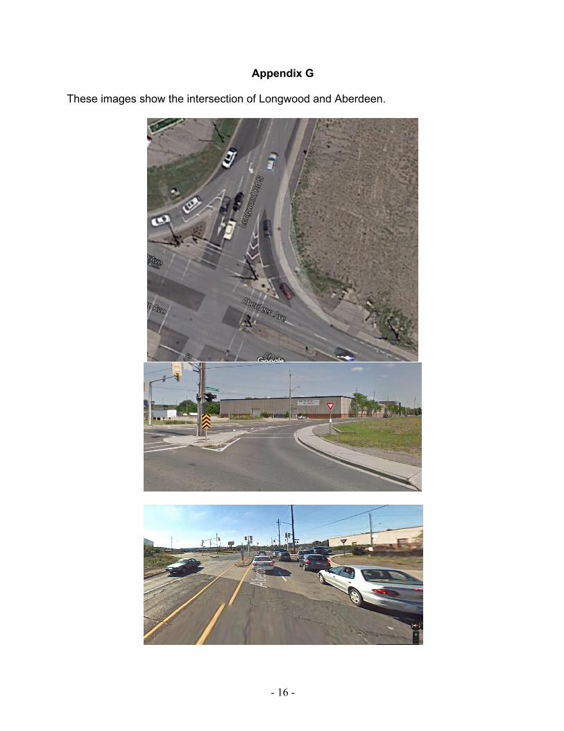
● Intersection with Longwood: (See Appendix G) The short, existing bike
lane on the north side of Aberdeen approaching Longwood is narrow, faded, and does not clearly intersect with the Longwood bike path. Westbound cyclists are not intuitively directed onto the Longwood bike path nor is there any indication that the paved path along Longwood is even intended for cyclists. Worse, eastbound cyclists traveling south along the Longwood bike path emerge into oncoming traffic where a highway-style on-ramp routes traffic north along Longwood with no stop sign, light, or safe method for cyclists to cross over to the eastbound Aberdeen lane. Solution: The bike path on Longwood should be clearly marked for cyclists and intuitively connected to cycling infrastructure on Aberdeen. See Proposals 1-5.
● Traffic back-up at Longwood and Aberdeen: (See Appendix G) The north lane
on Aberdeen at Longwood is regularly backed up for motorists at a red light because it is a mix of vehicles wanting to go straight to enter the 403 Toronto and vehicles turning right onto Longwood. Solution: Vehicular traffic would flow better if there was a dedicated right turn lane on Aberdeen and only one drive lane that flows straight through the intersection. After the intersection, cars could move right to go to Toronto or stay in the drive lane to go to Brantford.
Consideration would need to be given to how the right turn lane intersects safely with cycling infrastructure as noted above.
Proposals for Aberdeen Avenue The following five proposals for Aberdeen Avenue emerged following a brainstorming meeting of fifteen community members who use the street as drivers, cyclists, transit users and pedestrians. The meeting was held in October 2015 and further consultation extended into November involving a broader group in the Kirkendall Neighbourhood. In designing the proposals, we used a curb-to-curb width of 13 metres. While we present five distinct proposals, we acknowledge that the ideal solution may be a hybrid of different options. Also, certain sections of the street have different needs and thus solutions may need to be tailored to those sections as appropriate (e.g., west of Dundurn vs east). We appreciate the opportunity to provide input into this process, and look forward to working with the City to further this initiative. Respectfully, Kirkendall Aberdeen Task Force
- 5 -
Proposal 1: Continuous Cycle track on North Side
● Two-way cycle track on north side of Aberdeen, connecting directly (and clearly) with Longwood bike path
● Cycle track separated from traffic with curb or knock-down sticks ● Bike-boxes and signage where required ● One westbound and one eastbound drive lane ● One left turn lane down the middle ● All day parking with bump-outs along south side (serves also as buffer for south
sidewalk) ● South side HSR can stop at bump-outs, between parking strips ● North side HSR can stop at cycle track crossings similar to those installed at King
and Macklin St. (See Appendix H) ● Traffic calming on side streets ● Below is an approximate rendering looking east
Figure 1: Continuous Cycle Track on North Side
- 6 -
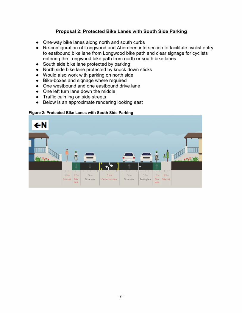
Proposal 2: Protected Bike Lanes with South Side Parking
● One-way bike lanes along north and south curbs ● Re-configuration of Longwood and Aberdeen intersection to facilitate cyclist entry
to eastbound bike lane from Longwood bike path and clear signage for cyclists entering the Longwood bike path from north or south bike lanes
● South side bike lane protected by parking ● North side bike lane protected by knock down sticks ● Would also work with parking on north side ● Bike-boxes and signage where required ● One westbound and one eastbound drive lane ● One left turn lane down the middle ● Traffic calming on side streets ● Below is an approximate rendering looking east
Figure 2: Protected Bike Lanes with South Side Parking
- 7 -
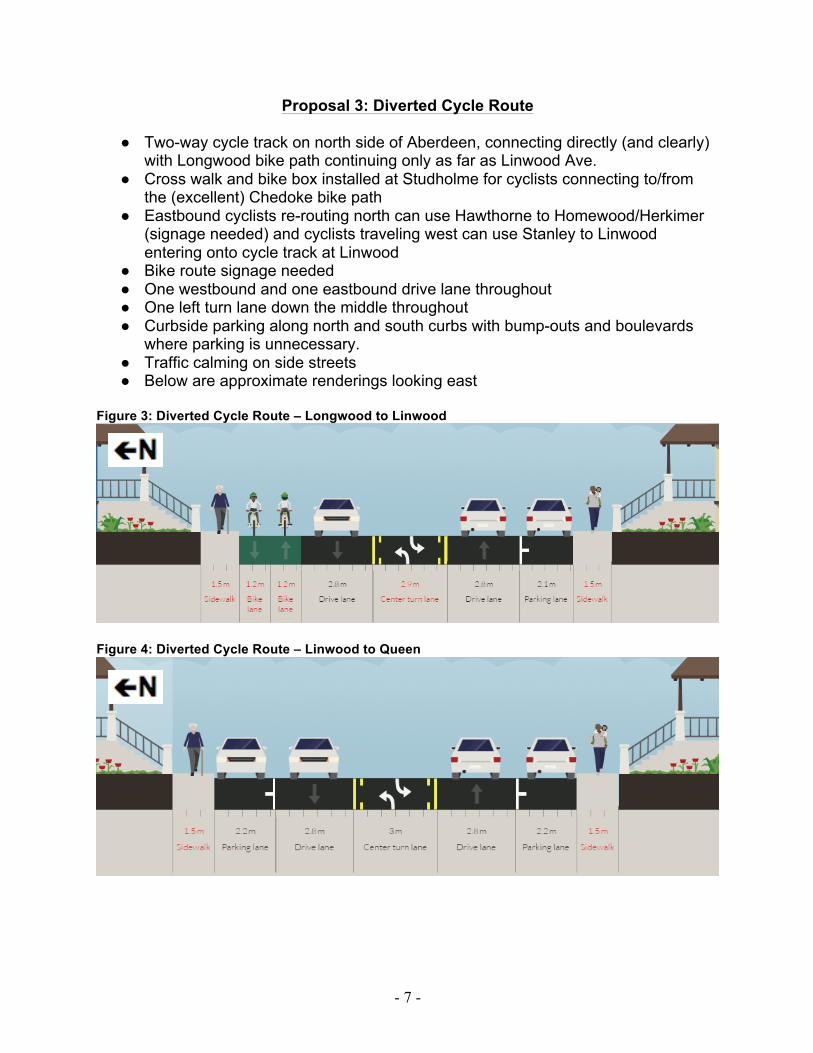
Proposal 3: Diverted Cycle Route
● Two-way cycle track on north side of Aberdeen, connecting directly (and clearly) with Longwood bike path continuing only as far as Linwood Ave.
● Cross walk and bike box installed at Studholme for cyclists connecting to/from the (excellent) Chedoke bike path
● Eastbound cyclists re-routing north can use Hawthorne to Homewood/Herkimer (signage needed) and cyclists traveling west can use Stanley to Linwood entering onto cycle track at Linwood
● Bike route signage needed ● One westbound and one eastbound drive lane throughout ● One left turn lane down the middle throughout ● Curbside parking along north and south curbs with bump-outs and boulevards
where parking is unnecessary. ● Traffic calming on side streets ● Below are approximate renderings looking east
Figure 3: Diverted Cycle Route – Longwood to Linwood
Figure 4: Diverted Cycle Route – Linwood to Queen
- 8 -
Proposal 4: Continuous Cycle Track on South Side
● Two-way cycle track on south side of Aberdeen, connecting directly (and clearly) with Longwood bike path, extending east to Hess
● Cycle track separated from traffic with space buffer, curb or knock-down sticks ● Bike-boxes and signage where required ● Two westbound and one eastbound drive lane, however north westbound lane
would allow parking during off peak hours (9AM to 4PM, and 6PM to 7AM) ● North sidewalk (where there is no grass strip between sidewalk and road) would
not have a buffer from traffic during rush hour ● This would result in an increase in parking availability in the neighbourhood ● Traffic calming on side streets ● Below is an approximate rendering looking east
Figure 5: Continuous Cycle Track on South Side
- 9 -
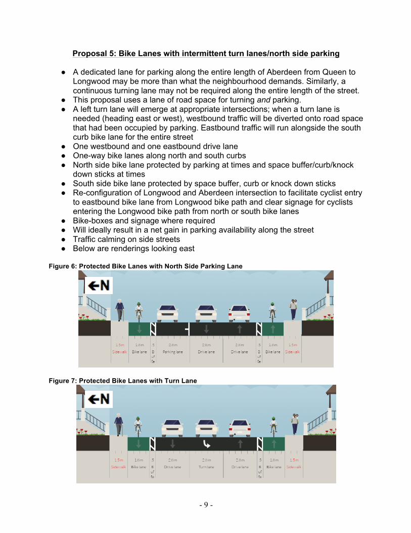
Proposal 5: Bike Lanes with intermittent turn lanes/north side parking
● A dedicated lane for parking along the entire length of Aberdeen from Queen to Longwood may be more than what the neighbourhood demands. Similarly, a continuous turning lane may not be required along the entire length of the street.
● This proposal uses a lane of road space for turning and parking. ● A left turn lane will emerge at appropriate intersections; when a turn lane is
needed (heading east or west), westbound traffic will be diverted onto road space that had been occupied by parking. Eastbound traffic will run alongside the south curb bike lane for the entire street
● One westbound and one eastbound drive lane ● One-way bike lanes along north and south curbs ● North side bike lane protected by parking at times and space buffer/curb/knock
down sticks at times ● South side bike lane protected by space buffer, curb or knock down sticks ● Re-configuration of Longwood and Aberdeen intersection to facilitate cyclist entry
to eastbound bike lane from Longwood bike path and clear signage for cyclists entering the Longwood bike path from north or south bike lanes
● Bike-boxes and signage where required ● Will ideally result in a net gain in parking availability along the street ● Traffic calming on side streets ● Below are renderings looking east
Figure 6: Protected Bike Lanes with North Side Parking Lane
Figure 7: Protected Bike Lanes with Turn Lane
- 10 -
Appendix A This map shows a major problem area on the south side of Aberdeen between Mountain and Undermount. This section of sidewalk is highly used by pedestrians on their way to Locke Street. There is no buffer between the sidewalk and vehicular traffic.
- 11 -
Appendix B The section of Aberdeen west of Chedoke (on both sides of the street) is not pedestrian friendly, despite heavy use by individuals walking to Westdale Secondary School and McMaster University.
- 12 -
Appendix C
Pedestrians must travel a long distance to cross side streets due to the wide turning radii.
- 13 -
Appendix D The stretch of Aberdeen between Dundurn and Locke has no pedestrian crossing. Cottage is half-way and also has a bus stop. This would be an ideal location for a pedestrian cross-walk.
- 14 -
Appendix E This map shows the intersection of Queen and Aberdeen, with the turn ramp for cars turning westbound when going south on Queen.
- 15 -
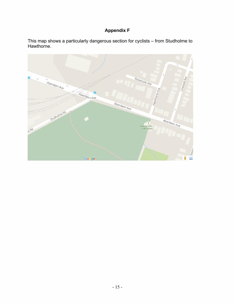
Appendix F This map shows a particularly dangerous section for cyclists – from Studholme to Hawthorne.
- 16 -
Appendix G These images show the intersection of Longwood and Aberdeen.
- 17 -
Appendix H
This image shows a crossing of the cycle track on King Street at Macklin Street in Westdale. A similar design for all proposals could be used on Aberdeen for HSR buses.