Page 1
ABORIGINAL HERITAGE OFFICE
Chapter 3 Site Management
Five Year Review 2010-2014
Written and compiled by the Aboriginal Heritage Office
Ku-ring-gai, Lane Cove, Manly, North Sydney, Pittwater,
City of Ryde, Warringah and Willoughby Councils.
Page 2
Acknowledgements
This report would not be possible without the co-operation of the following people and
organisations.
The Metropolitan Local Aboriginal Land Council,
The Aboriginal community of the region,
The local community of the region,
NSW Heritage Branch
The Department of Sustainability, Environment, Water, Population and Communities,
The NSW National Parks & Wildlife Service,
NSW Office of Environment and Heritage,
Councillors and Council Staff,
Aboriginal Heritage Office staff and consultants,
Aboriginal Heritage Office volunteers and interns.
Cover page: AHO staff, consultants, interns and volunteers in action during 2010-2014..
Page 3
Aboriginal Heritage Office Five Year Report 2010-2014 3
CONTENTS
3.0 Site Management and Protection .......................................................................................... 24
3.1 Site Inspections ........................................................................................................................... 24
3.2 Monitoring .................................................................................................................................. 31
Volunteer Monitoring .................................................................................................................... 37
Summary of Monitoring Results.................................................................................................... 37
3.3 Site Conservation Works ............................................................................................................. 37
2008 Site Conservation Report ...................................................................................................... 38
On-ground Works .......................................................................................................................... 39
Case Study: Balls Head Whale Engraving...................................................................................... 56
Site Signage ................................................................................................................................... 58
3.4 Recovery of Human Remains ...................................................................................................... 59
3.5 Working with the Australian Museum and other Specialists ..................................................... 61
3.6 Development Assessment........................................................................................................... 61
Reviewing DAs ............................................................................................................................... 62
References ................................................................................................................................. 65
Page 4
Aboriginal Heritage Office Five Year Report 2010-2014 24
3.0 SITE MANAGEMENT AND PROTECTION
Achieving conservation outcomes by successfully managing and protecting Aboriginal sites is a major
role of the Aboriginal Heritage Office (AHO). This involves working on strategies to protect sites
across all land-tenures that are influenced by Council activities and decisions. Over the last five years
the AHO has been involved in many local issues requiring site visits and assessments.
3.1 SITE INSPECTIONS
The AHO is often called out to inspect, assess and record Aboriginal sites or to assess the potential of
an area for unrecorded sites. Council staff, volunteers and residents regularly come across features
that are thought to be sites. Visiting sites and potential sites, examining material that has been
found by members of the public, providing reports for Land and Environment Court hearings and
doing artefact recording are just some of the tasks that are regularly undertaken.
Particular Council issues involving inspections for activities on Council land in 2013-2014 included
proposed track works or upgrades, site protection upgrades, hazard reduction burns, bush
regeneration activities, tree removals near sites, inspections of sites near developments, damage and
vandalism to sites, installation of memorials in potential site areas and much more.
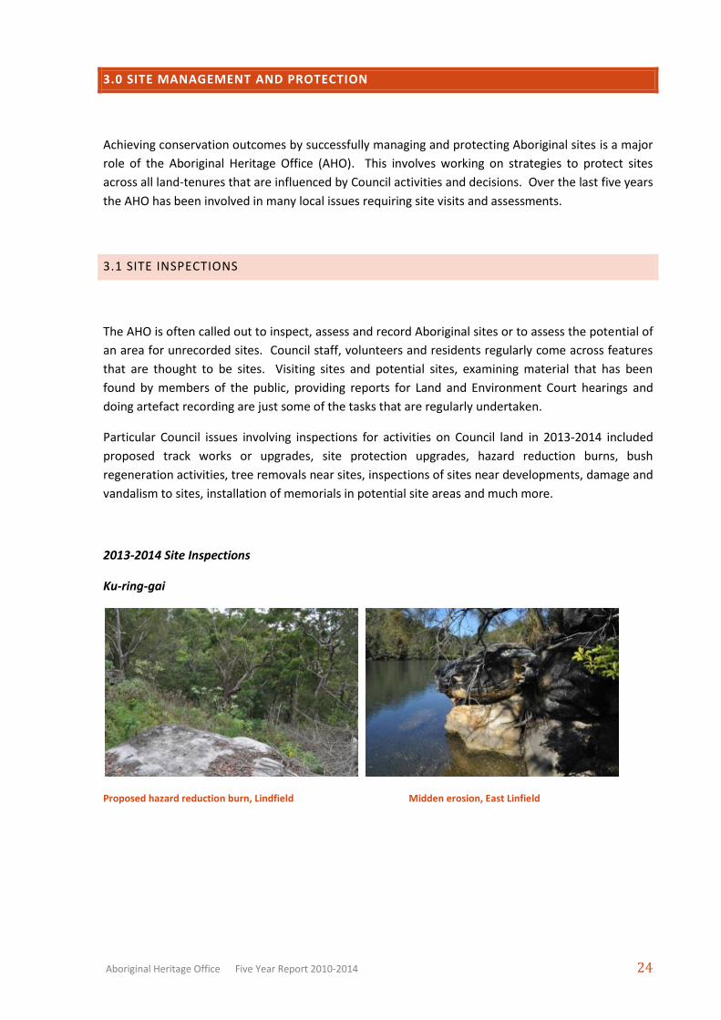
2013-2014 Site Inspections
Ku-ring-gai
Proposed hazard reduction burn, Lindfield Midden erosion, East Linfield
Page 5
Aboriginal Heritage Office Five Year Report 2010-2014 25
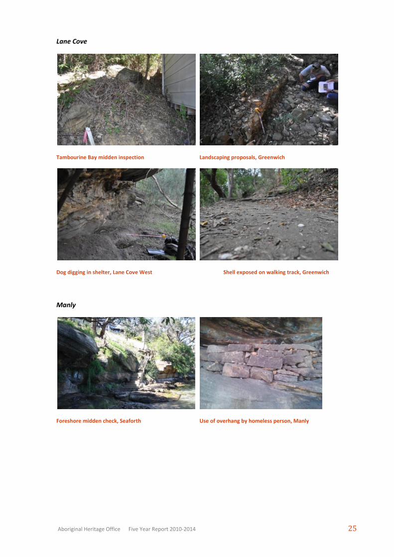
Lane Cove
Tambourine Bay midden inspection Landscaping proposals, Greenwich
Dog digging in shelter, Lane Cove West Shell exposed on walking track, Greenwich
Manly
Foreshore midden check, Seaforth Use of overhang by homeless person, Manly
Page 6
Aboriginal Heritage Office Five Year Report 2010-2014 26
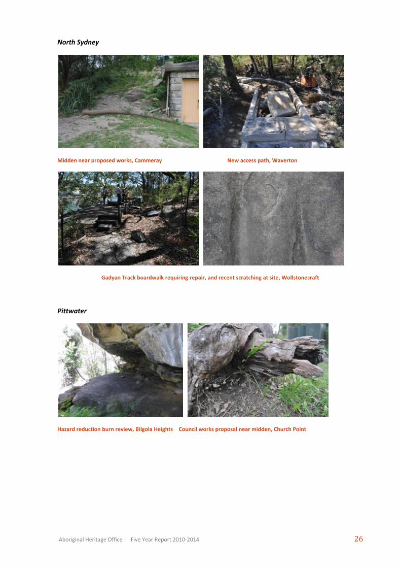
North Sydney
Midden near proposed works, Cammeray New access path, Waverton
Gadyan Track boardwalk requiring repair, and recent scratching at site, Wollstonecraft
Pittwater
Hazard reduction burn review, Bilgola Heights Council works proposal near midden, Church Point
Page 7
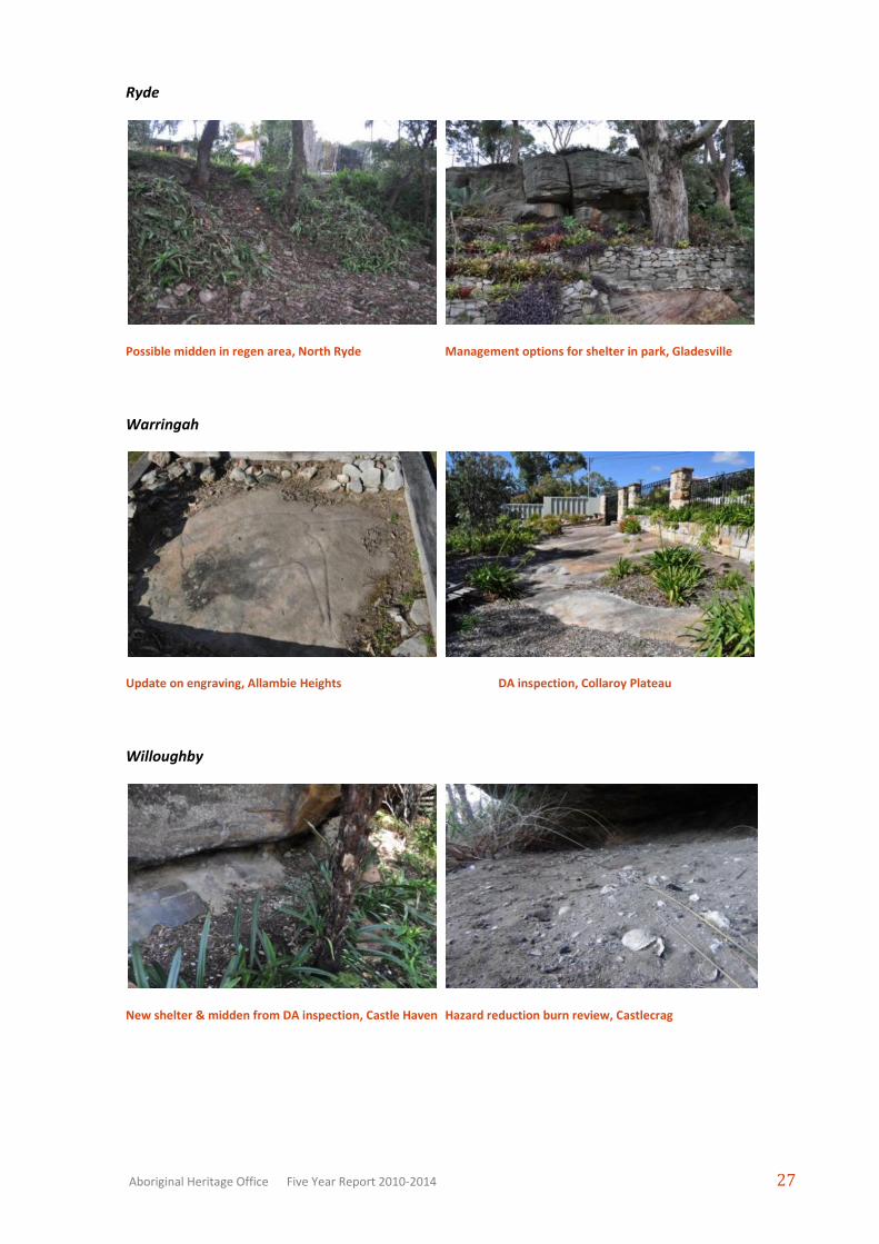
Aboriginal Heritage Office Five Year Report 2010-2014 27
Ryde
Possible midden in regen area, North Ryde Management options for shelter in park, Gladesville
Warringah
Update on engraving, Allambie Heights DA inspection, Collaroy Plateau
Willoughby
New shelter & midden from DA inspection, Castle Haven Hazard reduction burn review, Castlecrag
Page 8
Aboriginal Heritage Office Five Year Report 2010-2014 28
2012-2013 Site Inspections
Examining options at midden, Ku-ring-gai Dinghy storage racks protecting midden, North Sydney
Examining options at midden, Pittwater Graffiti on signs and rock, Ryde
Dredged shell in backyard, Willoughby Shelter near foreshore, Manly
Relocated engravings, Warringah New shelter during inspection, Lane Cove
Page 9
Aboriginal Heritage Office Five Year Report 2010-2014 29
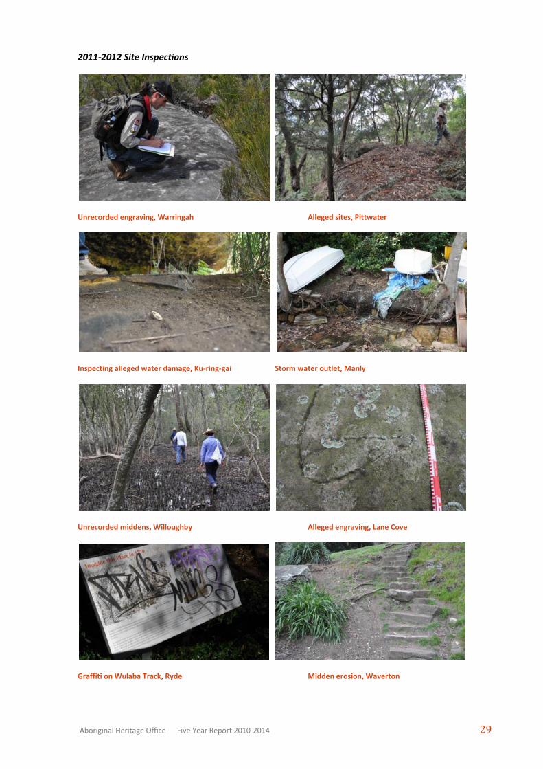
2011-2012 Site Inspections
Unrecorded engraving, Warringah Alleged sites, Pittwater
Inspecting alleged water damage, Ku-ring-gai Storm water outlet, Manly
Unrecorded middens, Willoughby Alleged engraving, Lane Cove
Graffiti on Wulaba Track, Ryde Midden erosion, Waverton
Page 10
Aboriginal Heritage Office Five Year Report 2010-2014 30
2010-2011 Site Inspections
On-site meeting at midden site, Warringah On-site meeting at engraving site, Nth Sydney.
Recording new site, Pittwater. Monitoring previous works, Warringah.
2009-2010
Stone artefact found at shelter, Lane Cove. Rock Engraving in backyard, North Sydney.
Page 11
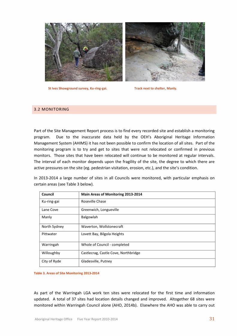
Aboriginal Heritage Office Five Year Report 2010-2014 31
St Ives Showground survey, Ku-ring-gai. Track next to shelter, Manly.
3.2 MONITORING
Part of the Site Management Report process is to find every recorded site and establish a monitoring
program. Due to the inaccurate data held by the OEH’s Aboriginal Heritage Information
Management System (AHIMS) it has not been possible to confirm the location of all sites. Part of the
monitoring program is to try and get to sites that were not relocated or confirmed in previous
monitors. Those sites that have been relocated will continue to be monitored at regular intervals.
The interval of each monitor depends upon the fragility of the site, the degree to which there are
active pressures on the site (eg. pedestrian visitation, erosion, etc.), and the site’s condition.
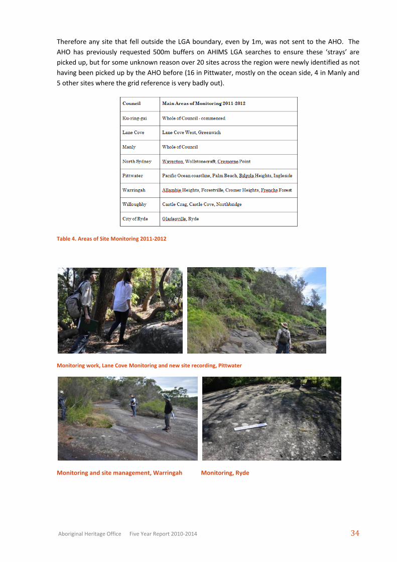
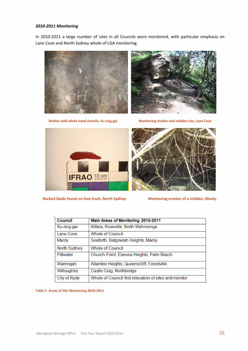
In 2013-2014 a large number of sites in all Councils were monitored, with particular emphasis on
certain areas (see Table 3 below).
Council Main Areas of Monitoring 2013-2014
Ku-ring-gai Roseville Chase
Lane Cove Greenwich, Longueville
Manly Balgowlah
North Sydney Waverton, Wollstonecraft
Pittwater Lovett Bay, Bilgola Heights
Warringah Whole of Council - completed
Willoughby Castlecrag, Castle Cove, Northbridge
City of Ryde Gladesville, Putney
Table 3. Areas of Site Monitoring 2013-2014
As part of the Warringah LGA work ten sites were relocated for the first time and information
updated. A total of 37 sites had location details changed and improved. Altogether 68 sites were
monitored within Warringah Council alone (AHO, 2014b). Elsewhere the AHO was able to carry out
Page 12
Aboriginal Heritage Office Five Year Report 2010-2014 32
planned as well as opportunistic monitoring of sites. For example, with the Rock Engraving, Coastal
Erosion Monitoring and Bushland Survey projects a large number of sites were visited and subject to
varying levels of re-recording and monitoring (AHO, 2013c, 2014a,2013a). For example 46 rock
engraving sites were visited and re-recorded, attempts to visit another 51 rock engraving sites were
made but were unsuccessful (access, visibility etc). During the Bushland Survey 12 new sites were
identified, along with the monitoring of 67 known sites. For the Coastal Erosion Monitoring project
16 sites are part of the regular monitoring program, while around 20 additional foreshore sites were
monitored.
Midden monitoring, Ku-ring-gai Rock engraving re-recording, Lane Cove
Rock engraving re-recording, Manly Rock engraving re-recording, North Sydney
Midden monitoring, Pittwater Midden monitoring, Ryde
Page 13
Aboriginal Heritage Office Five Year Report 2010-2014 33
Engraved tracks in shelter, Warringah Erosion from foot traffic, Willoughby
2012-2013 Monitoring
In this year the AHO finalised the full monitor of Manly, Ryde and Ku-ring-gai Councils, commenced
Willoughby and did selected areas of other Councils.
Monitoring engraving, Lane Cove Monitoring shelter site, Pittwater
Monitoring shelter, Manly Monitoring hand stencil site, North Sydney
2011-2012 Monitoring
In 2011-2012 the AHO discovered a number of registered sites that had not been forwarded to the
AHO previously, as well as new recordings, from AHIMS. As there are so many errors in the AHIMS
database some registered site locations have been recorded in the harbour or ocean and are not
included within a Council LGA (local government area) boundary when a search is done by LGA name.
Page 14
Aboriginal Heritage Office Five Year Report 2010-2014 34
Therefore any site that fell outside the LGA boundary, even by 1m, was not sent to the AHO. The
AHO has previously requested 500m buffers on AHIMS LGA searches to ensure these ‘strays’ are
picked up, but for some unknown reason over 20 sites across the region were newly identified as not
having been picked up by the AHO before (16 in Pittwater, mostly on the ocean side, 4 in Manly and
5 other sites where the grid reference is very badly out).
Table 4. Areas of Site Monitoring 2011-2012
Monitoring work, Lane Cove Monitoring and new site recording, Pittwater
Monitoring and site management, Warringah Monitoring, Ryde
Page 15
Aboriginal Heritage Office Five Year Report 2010-2014 35
2010-2011 Monitoring
In 2010-2011 a large number of sites in all Councils were monitored, with particular emphasis on
Lane Cove and North Sydney whole of LGA monitoring.
Shelter with white hand stencils, Ku-ring-gai Monitoring shelter and midden site, Lane Cove
Backed blade found on foot track, North Sydney Monitoring erosion of a midden, Manly.
Table 5. Areas of Site Monitoring 2010-2011
Page 16
Aboriginal Heritage Office Five Year Report 2010-2014 36
2009-2010 Monitoring
In 2009-2010 a large number of sites in all Councils were monitored, with particular emphasis on
rock art sites (as part of a federal grant project) and for the City of Ryde Council area as a whole.
Shelter with red hand stencils, Pittwater Recording open camp site, Armidale Dumaresq
Recording new midden, Willoughby. Mundoe (foot engraving) monitor, Warringah.
Table 6. Areas of Site Monitoring 2009-2010
Page 17
Aboriginal Heritage Office Five Year Report 2010-2014 37
VOLUNTEER MONITORING
This financial year saw the continuation of the volunteer monitoring program, which has resulted in
over 70 monitor reports for around 40 sites by AHO trained volunteers from the local community.
The volunteers notify the AHO if there are any noticeable changes to a site that may cause or has
caused damage (eg. graffiti, erosion and so on) (see Section 4.3 for more information).
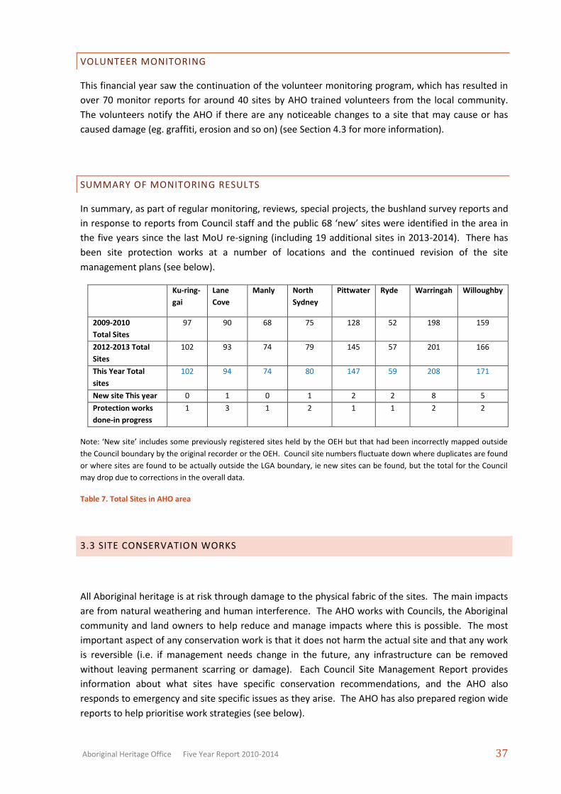
SUMMARY OF MONITORING RESULTS
In summary, as part of regular monitoring, reviews, special projects, the bushland survey reports and
in response to reports from Council staff and the public 68 ‘new’ sites were identified in the area in
the five years since the last MoU re-signing (including 19 additional sites in 2013-2014). There has
been site protection works at a number of locations and the continued revision of the site
management plans (see below).
Ku-ring-
gai
Lane
Cove
Manly North
Sydney
Pittwater Ryde Warringah Willoughby
2009-2010
Total Sites
97 90 68 75 128 52 198 159
2012-2013 Total
Sites
102 93 74 79 145 57 201 166
This Year Total
sites
102 94 74 80 147 59 208 171
New site This year 0 1 0 1 2 2 8 5
Protection works
done-in progress
1 3 1 2 1 1 2 2
Note: ‘New site’ includes some previously registered sites held by the OEH but that had been incorrectly mapped outside
the Council boundary by the original recorder or the OEH. Council site numbers fluctuate down where duplicates are found
or where sites are found to be actually outside the LGA boundary, ie new sites can be found, but the total for the Council
may drop due to corrections in the overall data.
Table 7. Total Sites in AHO area
3.3 SITE CONSERVATION WORKS
All Aboriginal heritage is at risk through damage to the physical fabric of the sites. The main impacts
are from natural weathering and human interference. The AHO works with Councils, the Aboriginal
community and land owners to help reduce and manage impacts where this is possible. The most
important aspect of any conservation work is that it does not harm the actual site and that any work
is reversible (i.e. if management needs change in the future, any infrastructure can be removed
without leaving permanent scarring or damage). Each Council Site Management Report provides
information about what sites have specific conservation recommendations, and the AHO also
responds to emergency and site specific issues as they arise. The AHO has also prepared region wide
reports to help prioritise work strategies (see below).
Page 18
Aboriginal Heritage Office Five Year Report 2010-2014 38
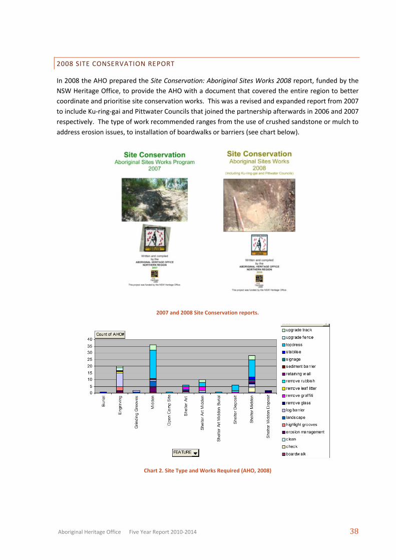
2008 SITE CONSERVATION REPORT
In 2008 the AHO prepared the Site Conservation: Aboriginal Sites Works 2008 report, funded by the
NSW Heritage Office, to provide the AHO with a document that covered the entire region to better
coordinate and prioritise site conservation works. This was a revised and expanded report from 2007
to include Ku-ring-gai and Pittwater Councils that joined the partnership afterwards in 2006 and 2007
respectively. The type of work recommended ranges from the use of crushed sandstone or mulch to
address erosion issues, to installation of boardwalks or barriers (see chart below).
2007 and 2008 Site Conservation reports.
Chart 2. Site Type and Works Required (AHO, 2008)
Page 19
Aboriginal Heritage Office Five Year Report 2010-2014 39
ON-GROUND WORKS
Over the last five years a large number of sites have received some on-ground attention to help
protect or ameliorate impacts to the site’s fabric. Site conservation involves many steps, from
consultation, preliminary assessments, the preparation of conservation plans and strategies,
monitoring, final approvals, the carrying out of works and follow up monitoring. Selected highlights
from each year are presented below, as well as more involved projects. In 2013-2014 additional
work was invested in specific sites through the Rock Engraving and Coastal Erosion Monitoring
projects (see Section 5.0).
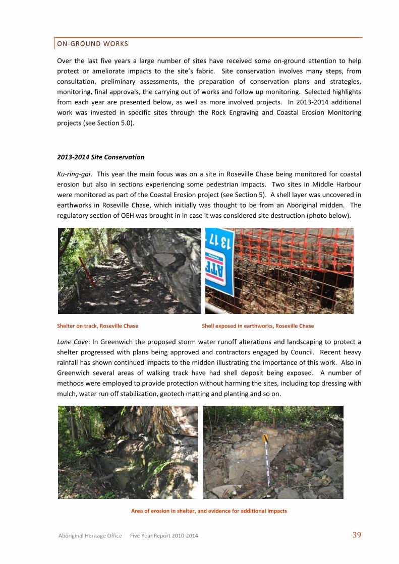
2013-2014 Site Conservation
Ku-ring-gai. This year the main focus was on a site in Roseville Chase being monitored for coastal
erosion but also in sections experiencing some pedestrian impacts. Two sites in Middle Harbour
were monitored as part of the Coastal Erosion project (see Section 5). A shell layer was uncovered in
earthworks in Roseville Chase, which initially was thought to be from an Aboriginal midden. The
regulatory section of OEH was brought in in case it was considered site destruction (photo below).
Shelter on track, Roseville Chase Shell exposed in earthworks, Roseville Chase
Lane Cove: In Greenwich the proposed storm water runoff alterations and landscaping to protect a
shelter progressed with plans being approved and contractors engaged by Council. Recent heavy
rainfall has shown continued impacts to the midden illustrating the importance of this work. Also in
Greenwich several areas of walking track have had shell deposit being exposed. A number of
methods were employed to provide protection without harming the sites, including top dressing with
mulch, water run off stabilization, geotech matting and planting and so on.
Area of erosion in shelter, and evidence for additional impacts
Page 20
Aboriginal Heritage Office Five Year Report 2010-2014 40
Track top dressing for midden in Greenwich, before and after
Manly: Inspections and recommendations were made at Seaforth, Clontarf and Balgowlah in terms of
coastal erosion issues as well as some track work issues near shell middens.
Midden exposed next to steps, Seaforth Dinghy storage area and midden, Seaforth
North Sydney: The main area of site conservation works this year has been at Wollstonecraft on the
Gadyan Track. The boardwalk and platform installed in the late 1990s required replacement and the
AHO assisted Council in reviewing the options and coming up with the new infrastructure. The
viewing platform was altered from the original design to avoid any permanent marks to original
features. The result was a wonderful sandstone block viewing area and seat protected from the
wind. The boardwalk around the rock engraving was improved from the original while still retaining
the intimate feeling of being close to the engraving. Signage will be renewed.
Gadyan Track platform and boardwalk upgrade
Page 21
Aboriginal Heritage Office Five Year Report 2010-2014 41
Pittwater: Several sites in the Pittwater and ocean shores examined as part of the Coastal Erosion
Monitoring project and management plans are being prepared for the two monitoring sites. At one
large shelter the AHO was alerted to unauthorized placement of mud over graffiti (photos below).
The danger of ill-prepared graffiti removal is that rock art can be irreversibly damaged.
Mud illegally placed over graffiti with digital enhancing showing possible ochre covered by mud
Ryde: The AHO responded to several acts of vandalism at Gladesville, mostly graffiti on interpretive
signage, but sometimes on rock outcrops. Unfortunatley the most recent was someone attempting
to re-groove or re-engraving the rock engravings. Not only is this highly illegal and culturally
inappropriate, it generally results in mistakes that alter the original engraved figure. The original
artists’ grooves are over-written by rushed, poorly controlled and incorrect scratching.
Unrecorded shell located on informal track, Putney Dead tree outside shelter, Gladesville
Illegal and damaging ‘re-grooving’ of grinding grooves (left) and ‘wallaby’ (right), Gladesville
Page 22
Aboriginal Heritage Office Five Year Report 2010-2014 42
Warringah. Most sites were examined as part of the whole of LGA review. Particular sites for
attention included new fake hand stencil vandalism in Allambie Heights, checking for damage from
bush fires near engravings in Forestville and a track at Cottage Point over a midden.
Disrupted stone arrangement, Cromer Fire damage near a rock engraving, Forestville
Cottage Point midden on track Large rock shelter wit graffiti damage, Frenchs Forest
Willoughby: A number of sites were investigated in terms of coastal erosion, which is a big problem
in Middle Harbour. A particular focus this year has been graffiti damage to an engraving site in
Northbridge (photos below).
Newly recorded midden in HR burn area, Castle Crag Eroding midden, Northbridge
Page 23
Aboriginal Heritage Office Five Year Report 2010-2014 43
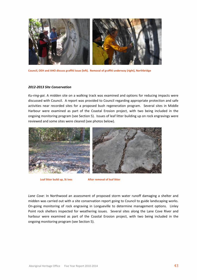
Council, OEH and AHO discuss graffiti issue (left). Removal of graffiti underway (right), Northbridge
2012-2013 Site Conservation
Ku-ring-gai. A midden site on a walking track was examined and options for reducing impacts were
discussed with Council. A report was provided to Council regarding appropriate protection and safe
activities near recorded sites for a proposed bush regeneration program. Several sites in Middle
Harbour were examined as part of the Coastal Erosion project, with two being included in the
ongoing monitoring program (see Section 5). Issues of leaf litter building up on rock engravings were
reviewed and some sites were cleared (see photos below).
Leaf litter build up, St Ives After removal of leaf litter
Lane Cove: In Northwood an assessment of proposed storm water runoff damaging a shelter and
midden was carried out with a site conservation report going to Council to guide landscaping works.
On-going monitoring of rock engraving in Longueville to determine management options. Linley
Point rock shelters inspected for weathering issues. Several sites along the Lane Cove River and
harbour were examined as part of the Coastal Erosion project, with two being included in the
ongoing monitoring program (see Section 5).
Page 24
Aboriginal Heritage Office Five Year Report 2010-2014 44
Eroding midden deposit, Northwood Erosion of midden, Linley Point
Manly: Inspections were made to advise on appropriate bush regeneration works near several
recorded sites in Clontarf and Balgowlah. A shelter in Manly was assessed for impacts and
management strategies following its use and modification by the homeless. A shelter was assessed
for potential impact from dinghy storage in Seaforth. Several sites in Middle Harbour, North Harbour
and the ocean shore were examined as part of the Coastal Erosion project, with two being included
in the ongoing monitoring program (see Section 5).
Graffiti in shelter, Manly Monitoring, Fairlight
North Sydney: Fine tuning of protection works at the ‘whale’ engraving in Waverton. The AHO and
Council have been working to reveal the original sandstone to try and find any lost engravings and to
provide better protection and landscaping for existing engravings. The AHO uncovered two
previously unrecorded figures. The work has finished and the site is now protected and promoted
through the Coal Loader Centre for Sustainability, although additional fences were installed by
Council to keep joggers and pedestrians from walking over the engravings (see Section 5 for details).
Pittwater: Several sites in the Pittwater and ocean shores examined as part of the Coastal Erosion
project, with two being included in the ongoing monitoring program (see Section 5). A number of
engraving sites were inspected with issues relating to vegetation cover (with moss, sediment and
overhanging branches becoming issues for sites). Conservation plans are being prepared A midden
site at Scotland Island was monitored and management options considered.
Page 25
Aboriginal Heritage Office Five Year Report 2010-2014 45
Dinghy storage racks protecting midden, Cammeray Mulch protecting midden, Woolstonecraft
Midden requiring protection works, Scotland Island Monitoring midden, Warriewood
Ryde: At Gladesville several visits were made and discussions regarding options to counter graffiti
attacks to signage and sites. Several sites along the Lane Cove and Parramatta Rivers were examined
as part of the Coastal Erosion project, with two being included in the ongoing monitoring program
(see Section 5).
Graffiti on rock platform, Gladeville Midden Erosion, Gladesville
Warringah. Examined sites at Wakehurst Council in relation to ongoing management issues,
including new fake hand stencil vandalism Assistance was given to a local resident with rock
engravings on property affected by illegal motorbike activity. Ongoing review of large engraving site
at Allambie Heights. Several sites in Middle Harbour and the ocean shore were examined as part of
Page 26
Aboriginal Heritage Office Five Year Report 2010-2014 46
the Coastal Erosion project, with two being included in the ongoing monitoring program (see Section
5).
At Forestville the AHO has been working with Council, the Metropolitan Local Aboriginal Land
Council, and the local National Park to protect an engraving site near the boundary of Council and
the National Park from bicycle and pedestrian traffic. A conservation plan was prepared and all
parties were awaiting OEH support. Unfortunately the OEH did not provide any assistance other
than to insist on application for an Aboriginal Heritage Impact Permit to ‘harm’ the site, despite
assurances that the work would not do any harm. The AHO initiated an independent review and it
was decided the only course of action was to close the track. The track closure is also affected by
planned mountain bike tracks in the area and no final decision has been made at time of printing.
Monitoring is continuing in the interim and bike traffic is still evident.
Inspecting engraving, Allambie Heights Motorbike tracks over engraving, Cromer Heights
Mountain bike tracks leading to engraving site. Kangaroo engraving, Forestville
Willoughby: a number of sites were inspected with erosion issues. The rinsing of vertical rock
engraving with onset of rock decay due to salt build up continued. A fine mist of water was sprayed
on the erosion to wash salt off. Additional sites reviewed for potential works, including middens
being eroded by wave action.
Several sites in Middle Harbour, North Harbour and the ocean shore were examined as part of the
Coastal Erosion project, with two being included in the ongoing monitoring program (see Section 5).
Page 27
Aboriginal Heritage Office Five Year Report 2010-2014 47
Graffiti on rock near shelter, Northbridge Monitoring work near, Castlecrag
Midden in tidal zone – gradual dieback of protective vegetation 2011-2013, Northbridge
2011-2012 Site Conservation
Ku-ring-gai. Assessment of a rock shelter subject to possible building-site storm water erosion. The
AHO inspected the shelter and liaised with the upslope land owner to determine the cause of the
damage. It was assessed as being a result of the unusually heavy rain and not a storm water issue. In
Roseville Chase the rinsing of a rock surface with onset of rock decay due to salt build up was carried
out. A fine mist of water was sprayed on the erosion to wash salt off and to promote rock-hardening
and stop erosion. Issues of leaf litter and vegetation cover building up on rock engravings became
more noticeable with the abundant growth this year.
Leaf litter build up, St Ives Rock decay, Roseville Chase
Lane Cove: on-going monitoring of rock engraving in Longueville to determine management options.
Linley Point rock shelters inspected for weathering issues. Tambourine Bay graffiti issue.
Page 28
Aboriginal Heritage Office Five Year Report 2010-2014 48
Graffiti in shelter Leaching issues, Linley Point
Manly: Balgowlah, after emergency works were carried out that necessitated a controlled drop of a
100 tonne overhang the AHO has continued the monitoring program for the small shell midden
beneath. There have been no erosion issues detected over the period to date. Also in Balgowlah,
ongoing monitoring has been carried out and discussions in regards to an eroding midden. At
Clontarf ongoing discussions were held regarding the upgrade of a walking track to help protect a
shell midden.
Track works, Clontarf Monitoring, Fairlight
North Sydney: finalization of protection works at the ‘whale’ engraving in Waverton. The AHO and
Council have been working to reveal the original sandstone to try and find any lost engravings and to
provide better protection and landscaping for existing engravings. The AHO uncovered two
previously unrecorded figures. The work has finished and the site is now protected and promoted
through the Coal Loader Centre for Sustainability.
At Cammeray, midden protection works have been completed with the installation of a formal track
and dinghy storage racks to stop the previous impacts associated with the boat storage from further
impacting the midden. Also in Cammeray the AHO assisted Council in identifying a previously
unrecorded midden and providing dinghy storage racks to prevent further impacts. In Cremorne
Point meetings were held to provide protection for a midden site and a buried engraving.
Page 29
Aboriginal Heritage Office Five Year Report 2010-2014 49
‘Echidna’ discovered, Waverton Engravings covered by turf, Cremorne Pt
Pittwater: a number of engraving sites were inspected with issues relating to vegetation cover (with
moss, sediment and overhanging branches becoming issues for sites). Conservation plans are being
prepared. An engraving at risk of development in Ingleside was visited and while development was
not an issue, vegetation cover was, and preparations for remedial action are being prepared. A
midden site at Scotland Island was monitored and management options considered.
Midden, Scotland Island Moss encroachment, Ingleside
Engraving covered by leaf litter, Ingleside Encroaching vegetation, Ingleside
Ryde: discussed management of open space near sites in Glades Bay to prevent impacts to Aboriginal
heritage, particularly dinghy storage near a midden, and vegetation encroachment and visitor
behavior at promoted sites on interpreted walk.
Page 30
Aboriginal Heritage Office Five Year Report 2010-2014 50
Midden near dinghy storage area Encroaching vegetation, Gladesville
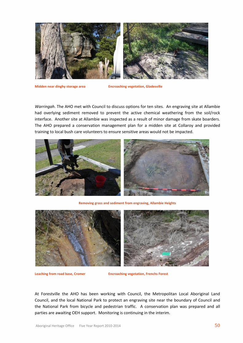
Warringah. The AHO met with Council to discuss options for ten sites. An engraving site at Allambie
had overlying sediment removed to prevent the active chemical weathering from the soil/rock
interface. Another site at Allambie was inspected as a result of minor damage from skate boarders.
The AHO prepared a conservation management plan for a midden site at Collaroy and provided
training to local bush care volunteers to ensure sensitive areas would not be impacted.
Removing grass and sediment from engraving, Allambie Heights
Leaching from road base, Cromer Encroaching vegetation, Frenchs Forest
At Forestville the AHO has been working with Council, the Metropolitan Local Aboriginal Land
Council, and the local National Park to protect an engraving site near the boundary of Council and
the National Park from bicycle and pedestrian traffic. A conservation plan was prepared and all
parties are awaiting OEH support. Monitoring is continuing in the interim.
Page 31
Aboriginal Heritage Office Five Year Report 2010-2014 51
Discussing protection options with Emma Lee and NPWS for engraving, Forestville
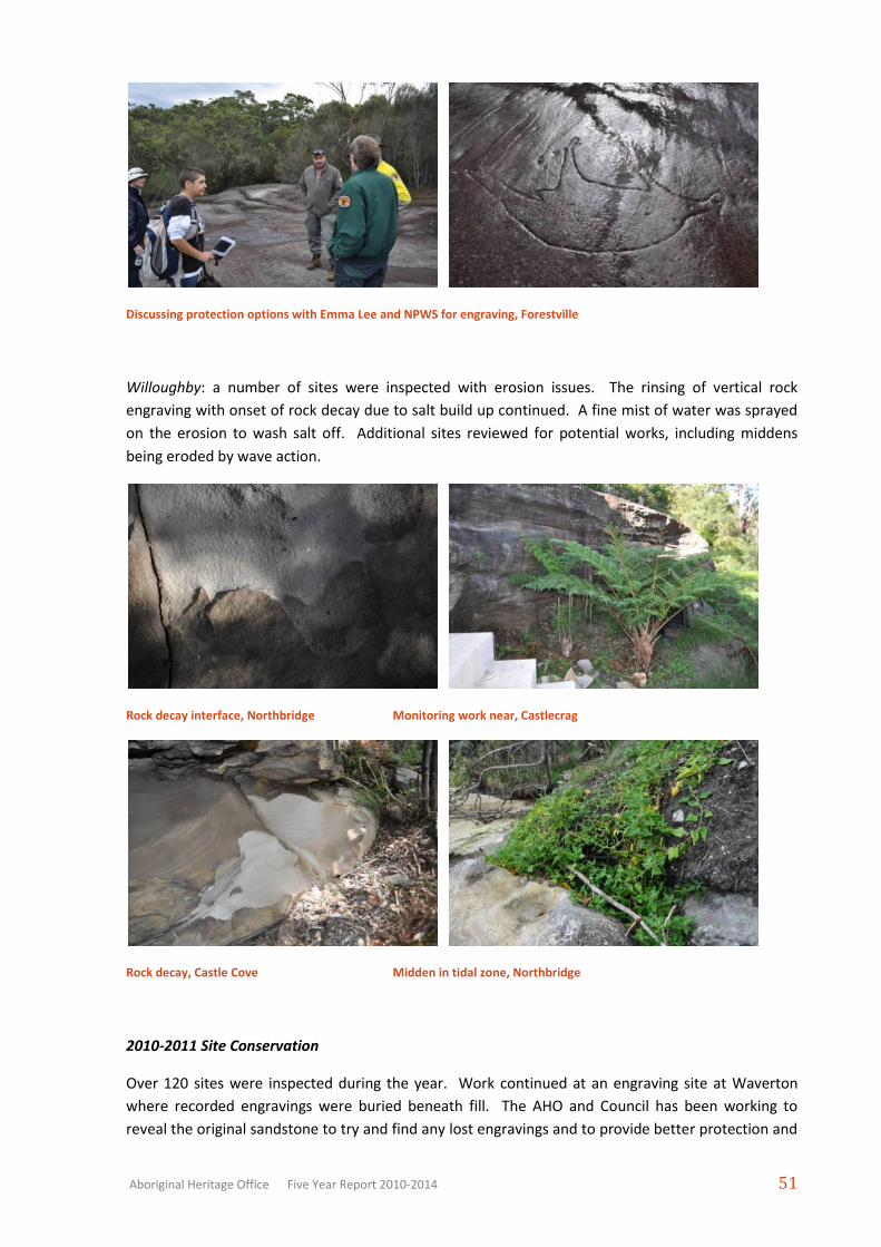
Willoughby: a number of sites were inspected with erosion issues. The rinsing of vertical rock
engraving with onset of rock decay due to salt build up continued. A fine mist of water was sprayed
on the erosion to wash salt off. Additional sites reviewed for potential works, including middens
being eroded by wave action.
Rock decay interface, Northbridge Monitoring work near, Castlecrag
Rock decay, Castle Cove Midden in tidal zone, Northbridge
2010-2011 Site Conservation
Over 120 sites were inspected during the year. Work continued at an engraving site at Waverton
where recorded engravings were buried beneath fill. The AHO and Council has been working to
reveal the original sandstone to try and find any lost engravings and to provide better protection and
Page 32
Aboriginal Heritage Office Five Year Report 2010-2014 52
landscaping for existing engravings. The AHO uncovered two previously unrecorded rock engraving.
Work has now largely finished. For a midden site in Cammeray, the site conservation plan was
revised and submitted with the permit application to the OEH with the approved DA that OEH had
required (the permit has now been issued). In Allambie an engraving site was protected from urban
development and the AHO provided a conservation management plan. In Forestville the AHO has
been working with Council and the local National Park to protect an engraving site near the boundary
of Council and the National Park. A draft conservation plan has been prepared. In Balgowlah the
AHO provided a conservation management and monitoring plan for a dangerous rock overhang that
required demolition so as to protect the underlying shell midden. In Collaroy the AHO prepared a
conservation plan for a midden to allow volunteer and contract bush regenerators to continue their
work without risking damage to the site.
Ku-ring-gai. Assessment of an open artefact scatter in relation to proposed playground upgrades.
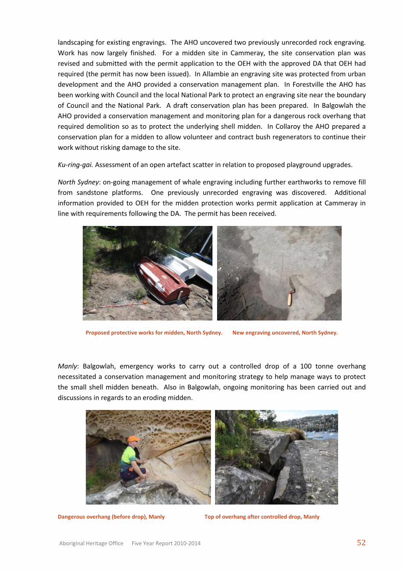
North Sydney: on-going management of whale engraving including further earthworks to remove fill
from sandstone platforms. One previously unrecorded engraving was discovered. Additional
information provided to OEH for the midden protection works permit application at Cammeray in
line with requirements following the DA. The permit has been received.
Proposed protective works for midden, North Sydney. New engraving uncovered, North Sydney.
Manly: Balgowlah, emergency works to carry out a controlled drop of a 100 tonne overhang
necessitated a conservation management and monitoring strategy to help manage ways to protect
the small shell midden beneath. Also in Balgowlah, ongoing monitoring has been carried out and
discussions in regards to an eroding midden.
Dangerous overhang (before drop), Manly Top of overhang after controlled drop, Manly
Page 33
Aboriginal Heritage Office Five Year Report 2010-2014 53
Warringah. An engraving site at Allambie was identified on private property but near the Council
boundary and a conservation plan was prepared to ensure the site’s protection. The AHO visited
sites with Council staff to determine site conservation policy, as well as specific works at Collaroy
where a conservation management plan for a midden site is in preparation. At Forestville a
conservation management plan was prepared to protect an engraving from bicycle and pedestrian
traffic.
Engraving on private property, Warringah Playground and open camp site, Ku-ring-gai
Engraving affected by mountain bikes, Warringah Meeting with Council and volunteer bush carers
re. site protection, Warringah.
Willoughby: cleaning of vertical rock engraving with onset of rock decay due to salt build up. A fine
mist of water was sprayed on the erosion to wash salt off. Additional sites reviewed for potential
works, including middens being eroded by wave action, rock shelters visited by campers, etc.
2009-2010 Site Conservation
Over 30 sites were inspected. Works plans have been completed or are in preparation for sites
including an engraving site, Waverton, a shell midden site at Cammeray, a shell midden site in
Balgowlah, engravings at Allambie and Forestville. Works at another Allambie site are complete (see
photo), and permits have been lodged with Department of Environment and Climate Change for two
more locations (Armidale and Cammeray) and these projects will be completed in due course (see
below for more detail).
Page 34
Aboriginal Heritage Office Five Year Report 2010-2014 54
Upgrading fence to protect midden, Warringah Landscaping works around engraving, Warringah
Engraving on private property, Warringah Engraving affected by foot traffic, Warringah.
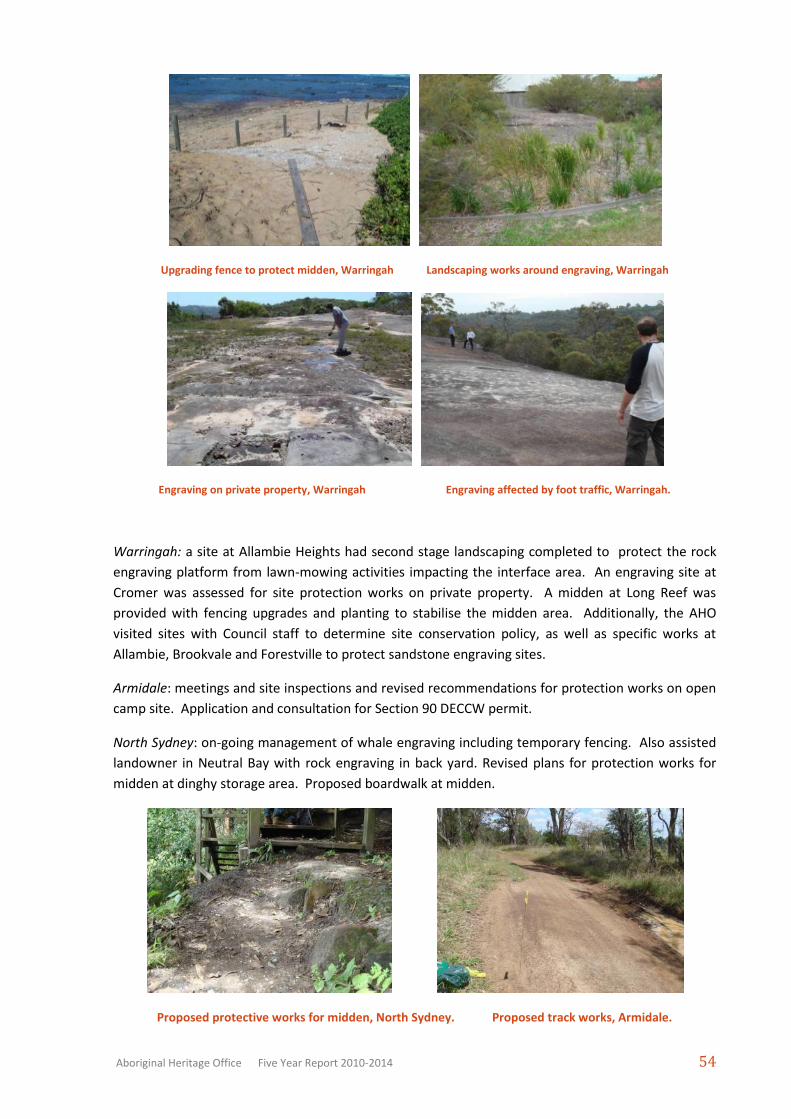
Warringah: a site at Allambie Heights had second stage landscaping completed to protect the rock
engraving platform from lawn-mowing activities impacting the interface area. An engraving site at
Cromer was assessed for site protection works on private property. A midden at Long Reef was
provided with fencing upgrades and planting to stabilise the midden area. Additionally, the AHO
visited sites with Council staff to determine site conservation policy, as well as specific works at
Allambie, Brookvale and Forestville to protect sandstone engraving sites.
Armidale: meetings and site inspections and revised recommendations for protection works on open
camp site. Application and consultation for Section 90 DECCW permit.
North Sydney: on-going management of whale engraving including temporary fencing. Also assisted
landowner in Neutral Bay with rock engraving in back yard. Revised plans for protection works for
midden at dinghy storage area. Proposed boardwalk at midden.
Proposed protective works for midden, North Sydney. Proposed track works, Armidale.
Page 35
Aboriginal Heritage Office Five Year Report 2010-2014 55
Eroding midden, Manly. Midden and Boat storage area, Pittwater
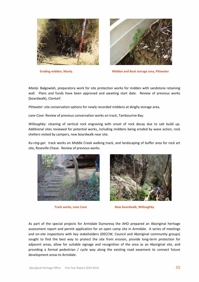
Manly: Balgowlah, preparatory work for site protection works for midden with sandstone retaining
wall. Plans and funds have been approved and awaiting start date. Review of previous works
(boardwalk), Clontarf.
Pittwater: site conservation options for newly recorded middens at dinghy storage area.
Lane Cove: Review of previous conservation works on track, Tambourine Bay.
Willoughby: cleaning of vertical rock engraving with onset of rock decay due to salt build up.
Additional sites reviewed for potential works, including middens being eroded by wave action, rock
shelters visited by campers, new boardwalk near site.
Ku-ring-gai: track works on Middle Creek walking track, and landscaping of buffer area for rock art
site, Roseville Chase. Review of previous works.
Track works, Lane Cove New boardwalk, Willoughby
As part of the special projects for Armidale Dumaresq the AHO prepared an Aboriginal heritage
assessment report and permit application for an open camp site in Armidale. A series of meetings
and on-site inspections with key stakeholders (DECCW, Council and Aboriginal community groups)
sought to find the best way to protect the site from erosion, provide long-term protection for
adjacent areas, allow for suitable signage and recognition of the area as an Aboriginal site, and
providing a formal pedestrian / cycle way along the existing road easement to connect future
development areas to Armidale.
Page 36
Aboriginal Heritage Office Five Year Report 2010-2014 56
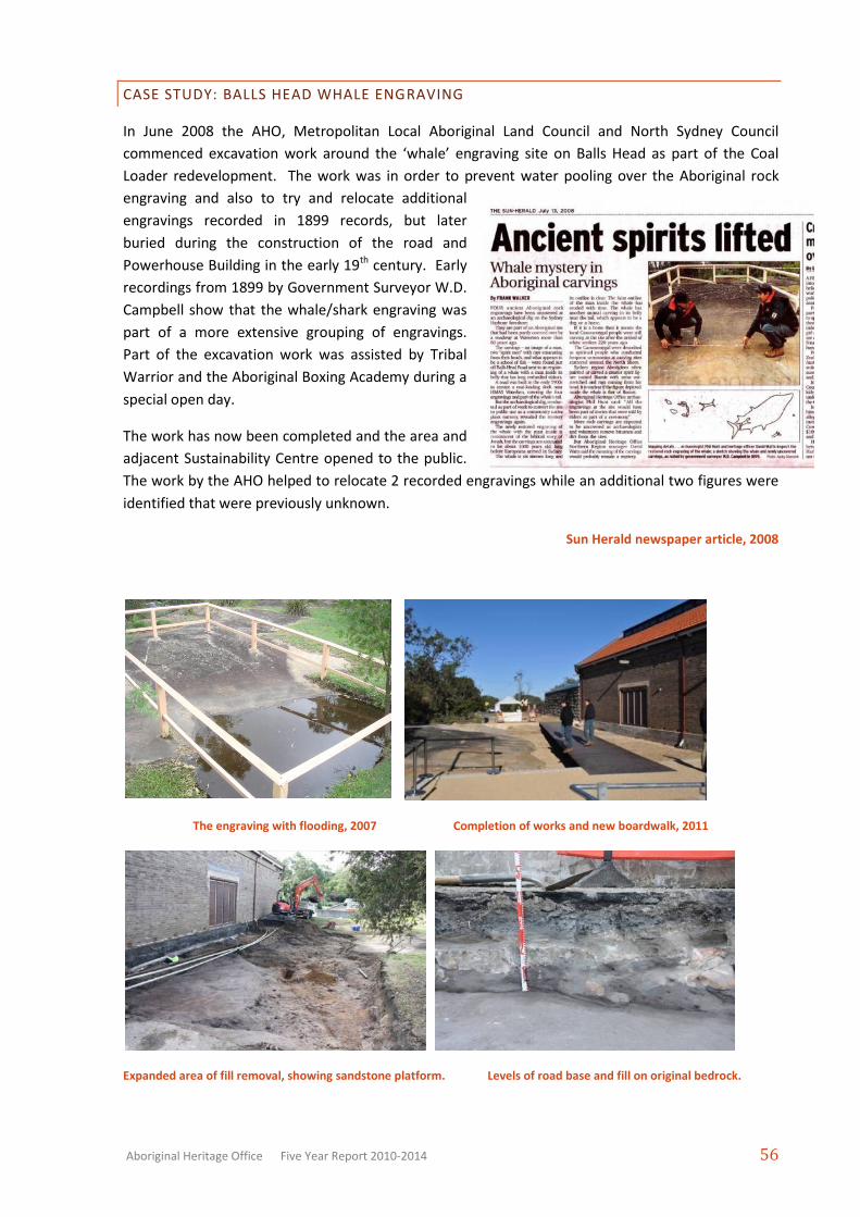
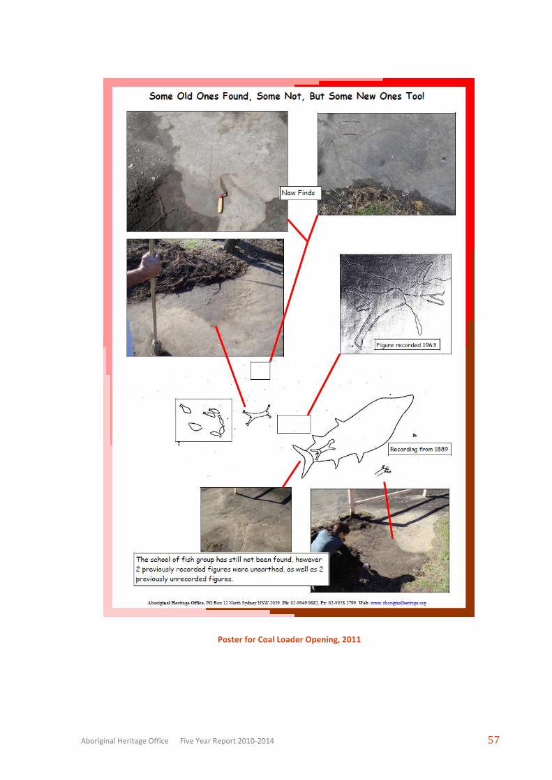
CASE STUDY: BALLS HEAD WHALE ENGRAVING
In June 2008 the AHO, Metropolitan Local Aboriginal Land Council and North Sydney Council
commenced excavation work around the ‘whale’ engraving site on Balls Head as part of the Coal
Loader redevelopment. The work was in order to prevent water pooling over the Aboriginal rock
engraving and also to try and relocate additional
engravings recorded in 1899 records, but later
buried during the construction of the road and
Powerhouse Building in the early 19th century. Early
recordings from 1899 by Government Surveyor W.D.
Campbell show that the whale/shark engraving was
part of a more extensive grouping of engravings.
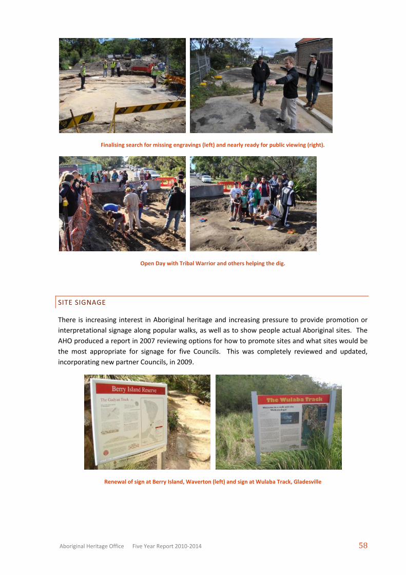
Part of the excavation work was assisted by Tribal
Warrior and the Aboriginal Boxing Academy during a
special open day.
The work has now been completed and the area and
adjacent Sustainability Centre opened to the public.
The work by the AHO helped to relocate 2 recorded engravings while an additional two figures were
identified that were previously unknown.
Sun Herald newspaper article, 2008
The engraving with flooding, 2007 Completion of works and new boardwalk, 2011
Expanded area of fill removal, showing sandstone platform. Levels of road base and fill on original bedrock.
Page 37
Aboriginal Heritage Office Five Year Report 2010-2014 57
Poster for Coal Loader Opening, 2011
Page 38
Aboriginal Heritage Office Five Year Report 2010-2014 58
Finalising search for missing engravings (left) and nearly ready for public viewing (right).
Open Day with Tribal Warrior and others helping the dig.
SITE SIGNAGE
There is increasing interest in Aboriginal heritage and increasing pressure to provide promotion or
interpretational signage along popular walks, as well as to show people actual Aboriginal sites. The
AHO produced a report in 2007 reviewing options for how to promote sites and what sites would be
the most appropriate for signage for five Councils. This was completely reviewed and updated,
incorporating new partner Councils, in 2009.
Renewal of sign at Berry Island, Waverton (left) and sign at Wulaba Track, Gladesville
Page 39
Aboriginal Heritage Office Five Year Report 2010-2014 59
New sign at St Ives and Sign at beginning of track at East Killara, Ku-ring-gai Council
Using signs can help promote Aboriginal heritage and help prevent damage from ignorance of a
place’s importance, but it can also provoke vandalism. There is anecdotal evidence by reserve and
heritage managers that signs can help as a ‘decoy’ for malicious damage – ie the sign is attacked but
the site is not.
Current work involves reviewing options for signage where they arise and working to complete
previously recommended work. Research to prepare suitable text and graphics was carried out
across the region. Draft material was sent to the appropriate land owner. See the Education report
for more (Section 4).
3.4 RECOVERY OF HUMAN REMAINS
While there were fortunately no Aboriginal burials uncovered this year, the AHO was still called out
on two occasions to do a preliminary assessment for human remains. Bushland staff in Willoughby
alerted the AHO to a very low overhang with many bones (photos below). It wasn’t long before it
was determined that a local dog must have been bringing his tasty butcher treats from home to stash
in this hideout!
Bone cache under rock (left), and sample of bones of various species with saw marks etc (right).
Page 40
Aboriginal Heritage Office Five Year Report 2010-2014 60
The other case this year was when a very young local resident found something on a local beach that
looked like bone. The bone did not appear to be human and had become largely petrified. The AHO
sought help from the Shellshear Museum and the Australian Museum. While not conclusive, the
opinion was that the bone was from a Dugong from around a thousand years ago. Toby the young
finder of the bone was very pleased to have his favourite item returned (as was him mother who no
longer had to try and explain why it was all taking so long).
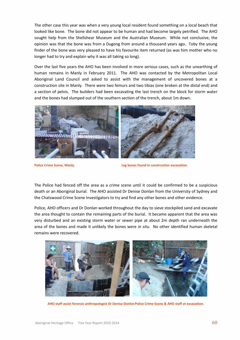
Over the last five years the AHO has been involved in more serious cases, such as the unearthing of
human remains in Manly in February 2011. The AHO was contacted by the Metropolitan Local
Aboriginal Land Council and asked to assist with the management of uncovered bones at a
construction site in Manly. There were two femurs and two tibias (one broken at the distal end) and
a section of pelvis. The builders had been excavating the last trench on the block for storm water
and the bones had slumped out of the southern section of the trench, about 1m down.
Police Crime Scene, Manly. Leg bones found in construction excavation.
The Police had fenced off the area as a crime scene until it could be confirmed to be a suspicious
death or an Aboriginal burial. The AHO assisted Dr Denise Donlan from the University of Sydney and
the Chatswood Crime Scene Investigators to try and find any other bones and other evidence.
Police, AHO officers and Dr Donlan worked throughout the day to sieve stockpiled sand and excavate
the area thought to contain the remaining parts of the burial. It became apparent that the area was
very disturbed and an existing storm water or sewer pipe at about 2m depth ran underneath the
area of the bones and made it unlikely the bones were in situ. No other identified human skeletal
remains were recovered.
AHO staff assist forensic anthropologist Dr Denise Donlon Police Crime Scene & AHO staff at excavation.
Page 41
Aboriginal Heritage Office Five Year Report 2010-2014 61
Dr Donlan informed Police and the AHO the next day that the remains were considered to be
Aboriginal (a mature female). As the remains were now no longer deemed to be a police matter, the
police informed the OEH (then the Department of Environment, Climate Change, and Water).
Aboriginal remains come under the protection of the National Parks and Wildlife Act 1974, which is
administered by OEH. The OEH liased with the MLALC and the builders to determine the next steps.
It should be noted that the builders, Open Plan Living, cooperated fully and helpfully with authorities
from the outset and were always willing to assist in whatever way they could, including particular
attention to the health and safety of the many visitors to the site.
3.5 WORKING WITH THE AUSTRALIAN MUSEUM AND OTHER SPECIALISTS
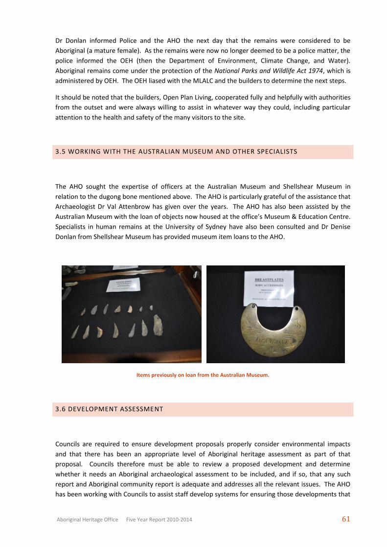
The AHO sought the expertise of officers at the Australian Museum and Shellshear Museum in
relation to the dugong bone mentioned above. The AHO is particularly grateful of the assistance that
Archaeologist Dr Val Attenbrow has given over the years. The AHO has also been assisted by the
Australian Museum with the loan of objects now housed at the office’s Museum & Education Centre.
Specialists in human remains at the University of Sydney have also been consulted and Dr Denise
Donlan from Shellshear Museum has provided museum item loans to the AHO.
Items previously on loan from the Australian Museum.
3.6 DEVELOPMENT ASSESSMENT
Councils are required to ensure development proposals properly consider environmental impacts
and that there has been an appropriate level of Aboriginal heritage assessment as part of that
proposal. Councils therefore must be able to review a proposed development and determine
whether it needs an Aboriginal archaeological assessment to be included, and if so, that any such
report and Aboriginal community report is adequate and addresses all the relevant issues. The AHO
has been working with Councils to assist staff develop systems for ensuring those developments that
Page 42
Aboriginal Heritage Office Five Year Report 2010-2014 62
could have an impact on Aboriginal heritage are flagged and those that have no concern are not
delayed or caught up in unnecessary assessment work. The AHO provides strategic planning
documents, it reviews Council procedures, processes and documents, it provides training for staff,
contractors and volunteers, Land and Environment Court expert witness services and other support
as required.
REVIEWING DAS
The AHO undertakes the review of development assessments (DAs) and environmental impact
assessments (EIS) when required. The AHO provides a support role in ensuring assessment reports
covering Aboriginal archaeological and cultural issues are reviewed to the standards as set out by the
OEH.
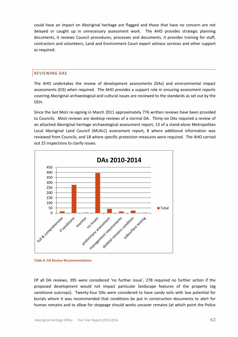
Since the last MoU re-signing in March 2011 approximately 776 written reviews have been provided
to Councils. Most reviews are desktop reviews of a normal DA. Thirty-six DAs required a review of
an attached Aboriginal heritage archaeological assessment report, 13 of a stand-alone Metropolitan
Local Aboriginal Land Council (MLALC) assessment report, 8 where additional information was
reviewed from Councils, and 18 where specific protection measures were required. The AHO carried
out 25 inspections to clarify issues.
Table 8. DA Review Recommendations
Of all DA reviews, 395 were considered ‘no further issue’, 278 required no further action if the
proposed development would not impact particular landscape features of the property (eg
sandstone outcrops). Twenty-four DAs were considered to have sandy soils with low potential for
burials where it was recommended that conditions be put in construction documents to alert for
human remains and to allow for stoppage should works uncover remains (at which point the Police
0
50
100
150
200
250
300
350
400
450
DAs 2010-2014
Total
Page 43
Aboriginal Heritage Office Five Year Report 2010-2014 63
would need to be brought in to determine whether it was a crime scene). This approach has worked
in the past, most notably at a development in Manly in 2011 where an Aboriginal burial was
uncovered.
One DA in North Sydney resulted in a previously unrecorded Aboriginal site being identified and the
AHO was requested to assist Council’s legal representatives at the case went to the Land and
Environment Court on several issues. The outcome ensured protection of the shelter and midden
whilst allowing the house development to proceed with some modifications (on many grounds,
including heritage).
The remaining DAs required more information of one kind or another. Some only required more
photographs or information supplied by Council staff. Sixteen DAs were recommended for ‘full and
comprehensive’ assessments, three for ‘subsurface testing’, 41 for preliminary assessment and 15
DAs had an Aboriginal heritage issue requiring certain recommendations to be followed to ensure
the protection of the site. The AHO carried out inspections for 25 DAs.
To improve the efficiency of DA referrals the AHO created an email address dedicated for all such
referrals ([email protected] ). Planning staff forward information digitally
and the communication and tracking of particular DAs is simple and clear. Training for Council
planners is provided by the AHO, including an intermediate level training for planners/team leaders
introduced in 2010 (see section 4.1). The AHO considers it imperative that Council staff become
more familiar with local Aboriginal heritage to ensure that site issues are picked up at every level,
rather than assuming a referral process or AHO-type body will be able to meet all of Council’s needs
and responsibilities.
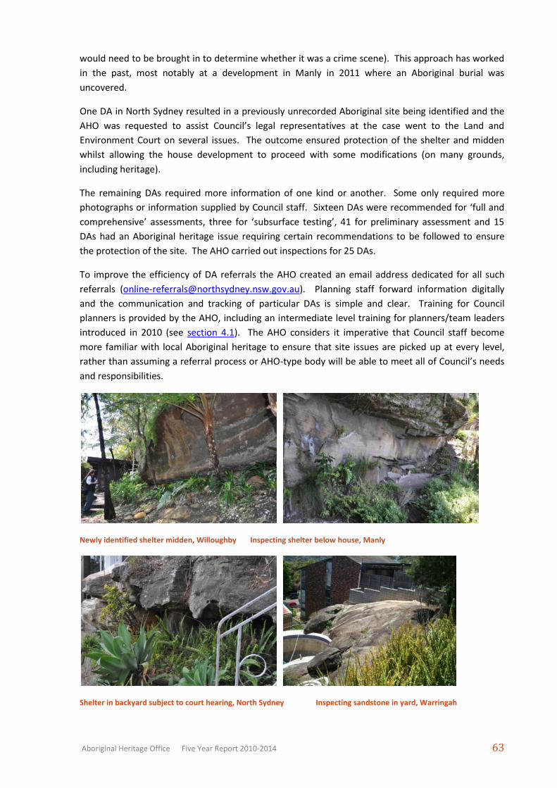
Newly identified shelter midden, Willoughby Inspecting shelter below house, Manly
Shelter in backyard subject to court hearing, North Sydney Inspecting sandstone in yard, Warringah
Page 44
Aboriginal Heritage Office Five Year Report 2010-2014 64
Shelter near house, Warringah DA above shelter with art, Willoughby
Shell on ground at edge of proposed DA, Pittwater Shell exposed in landscaping works, Lane Cove
Page 45
Aboriginal Heritage Office Five Year Report 2010-2014 65
REFERENCES
Aboriginal Heritage Office. 2007. Site Conservation: Aboriginal Sites Works Program 2007. Report
funded by the NSW Heritage Office, Sydney.
Aboriginal Heritage Office. 2008. Site Conservation: Aboriginal Sites Works Program 2008. Report
funded by the NSW Heritage Office, Sydney.
Aboriginal Heritage Office. 2013a. Bushland Reserve Site Survey, Northern Sydney Stage 2, 2013.
Report funded by Department of Sustainability, Environment, Water, Population and
Communities, Canberra.
Aboriginal Heritage Office. 2013b. Rock Engraving Aboriginal Heritage Project 2013, Northern
Sydney. Report funded by Department of Sustainability, Environment, Water, Population and
Communities, Canberra.
Aboriginal Heritage Office. 2014a. Coastal Erosion Aboriginal Heritage Project, Northern Sydney
2013-2014 Year 1. Report funded by Department of Sustainability, Environment, Water,
Population and Communities, Canberra.
Aboriginal Heritage Office. 2014b. Warringah Council Aboriginal Site Management Report 2014.
Report prepared for Warringah Council, Sydney.