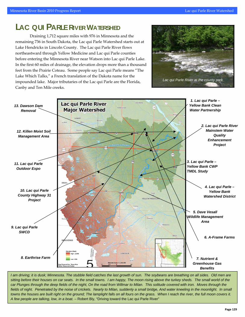
Minnesota River Basin 2010 Progress Report Lac qui Parle River Watershed LAC QUI PARLE RIVER WATERSHED Draining 1,712 square miles with 976 in Minnesota and the remaining 736 in South Dakota, the Lac qui Parle Watershed starts out at Lake Hendricks in Lincoln County. The Lac qui Parle River flows northeastward through Yellow Medicine and Lac qui Parle counties before entering the Minnesota River near Watson into Lac qui Parle Lake. In the first 60 miles of drainage, the elevation drops more than a thousand feet from the Prairie Coteau. Some people say Lac qui Parle means “The Lake Which Talks,” a French translation of the Dakota name for the impounded lake. Major tributaries of the Lac qui Parle are the Florida, Canby and Ten Mile creeks. Lac qui Parle River at the county park 1. Lac qui Parle – Yellow Bank Clean Water Partnership 2. Lac qui Parle River Mainstem Water Quality Enhancement Project 3. Lac qui Parle – Yellow Bank CWP TMDL Study 4. Lac qui Parle – Yellow Bank Watershed District 5. Dave Vesall Wildlife Management Area 6. A-Frame Farms 7. Nutrient & Greenhouse Gas Benefits 8. Earthrise Farm 9. Lac qui Parle SWCD 10. Lac qui Parle County Highway 31 Project 11. Lac qui Parle Outdoor Expo 12. Killen Moist Soil Management Area 13. Dawson Dam Removal I am driving; it is dusk; Minnesota. The stubble field catches the last growth of sun. The soybeans are breathing on all sides. Old men are sitting before their houses on car seats. In the small towns. I am happy, The moon rising above the turkey sheds. The small world of the car Plunges through the deep fields of the night, On the road from Willmar to Milan. This solitude covered with iron. Moves through the fields of night. Penetrated by the noise of crickets. Nearly to Milan, suddenly a small bridge, And water kneeling in the moonlight. In small towns the houses are built right on the ground; The lamplight falls on all fours on the grass. When I reach the river, the full moon covers it. A few people are talking, low, in a boat. – Robert Bly, “Driving toward the Lac qui Parle River” Page 129
Transcript
Minnesota River Basin 2010 Progress Report Lac qui Parle River Watershed
LAC QUI PARLE RIVER WATERSHED Draining 1,712 square miles with 976 in Minnesota and the
remaining 736 in South Dakota, the Lac qui Parle Watershed starts out at Lake Hendricks in Lincoln County. The Lac qui Parle River flows northeastward through Yellow Medicine and Lac qui Parle counties before entering the Minnesota River near Watson into Lac qui Parle Lake. In the first 60 miles of drainage, the elevation drops more than a thousand feet from the Prairie Coteau. Some people say Lac qui Parle means “The Lake Which Talks,” a French translation of the Dakota name for the impounded lake. Major tributaries of the Lac qui Parle are the Florida, Canby and Ten Mile creeks.
Lac qui Parle River at the county park
1. Lac qui Parle – Yellow Bank Clean Water Partnership
2. Lac qui Parle River Mainstem Water
Quality Enhancement
Project
3. Lac qui Parle – Yellow Bank CWP TMDL Study
4. Lac qui Parle – Yellow Bank
Watershed District
5. Dave Vesall Wildlife Management
Area
6. A-Frame Farms
7. Nutrient & Greenhouse Gas
Benefits
8. Earthrise Farm
9. Lac qui Parle SWCD
10. Lac qui Parle County Highway 31
Project
11. Lac qui Parle Outdoor Expo
12. Killen Moist Soil Management Area
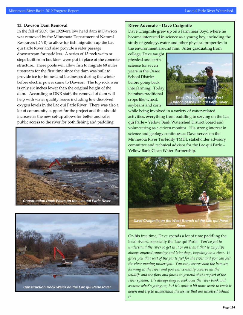
13. Dawson Dam Removal
I am driving; it is dusk; Minnesota. The stubble field catches the last growth of sun. The soybeans are breathing on all sides. Old men are sitting before their houses on car seats. In the small towns. I am happy, The moon rising above the turkey sheds. The small world of the car Plunges through the deep fields of the night, On the road from Willmar to Milan. This solitude covered with iron. Moves through the fields of night. Penetrated by the noise of crickets. Nearly to Milan, suddenly a small bridge, And water kneeling in the moonlight. In small towns the houses are built right on the ground; The lamplight falls on all fours on the grass. When I reach the river, the full moon covers it. A few people are talking, low, in a boat. – Robert Bly, “Driving toward the Lac qui Parle River”
Page 129
Minnesota River Basin 2010 Progress Report Lac qui Parle River Watershed
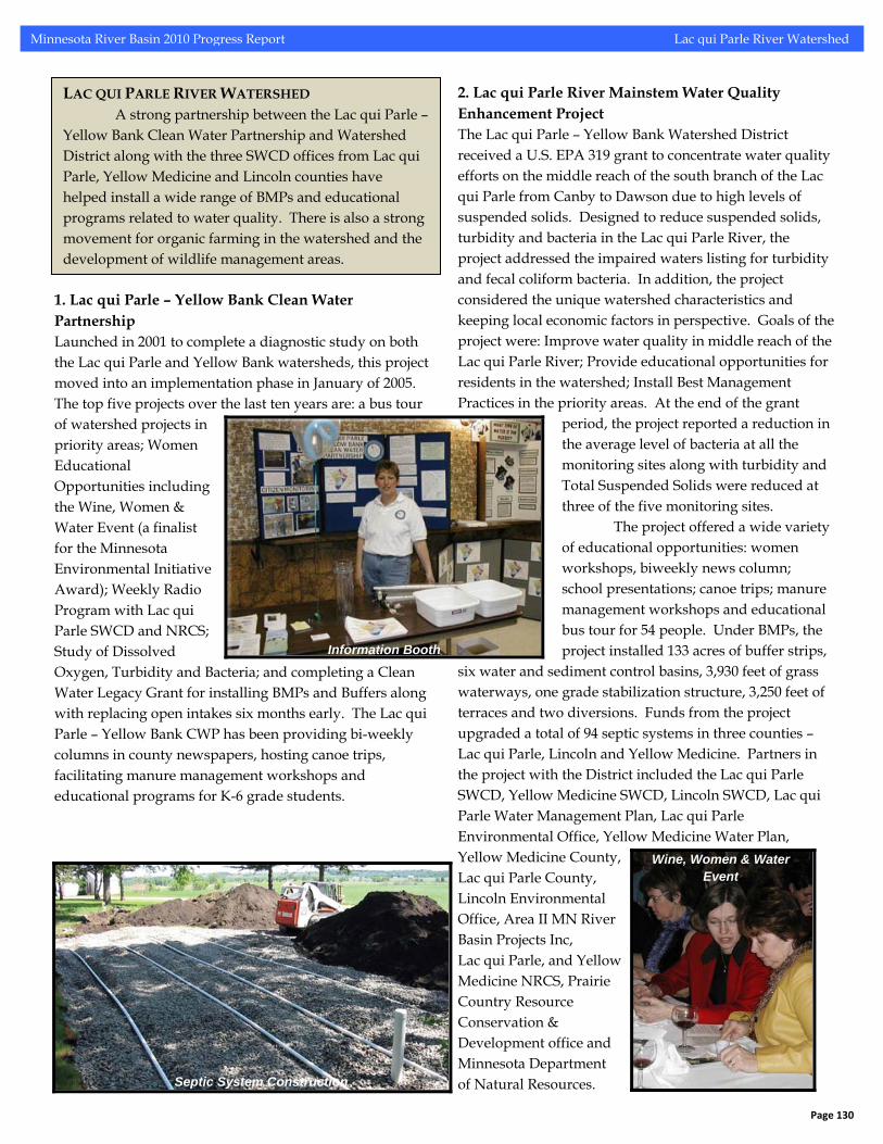
1. Lac qui Parle – Yellow Bank Clean Water Partnership Launched in 2001 to complete a diagnostic study on both the Lac qui Parle and Yellow Bank watersheds, this project moved into an implementation phase in January of 2005. The top five projects over the last ten years are: a bus tour of watershed projects in priority areas; Women Educational Opportunities including the Wine, Women & Water Event (a finalist for the Minnesota Environmental Initiative Award); Weekly Radio Program with Lac qui Parle SWCD and NRCS; Study of Dissolved Oxygen, Turbidity and Bacteria; and completing a Clean Water Legacy Grant for installing BMPs and Buffers along with replacing open intakes six months early. The Lac qui Parle – Yellow Bank CWP has been providing bi-weekly columns in county newspapers, hosting canoe trips, facilitating manure management workshops and educational programs for K-6 grade students.
2. Lac qui Parle River Mainstem Water Quality Enhancement Project The Lac qui Parle – Yellow Bank Watershed District received a U.S. EPA 319 grant to concentrate water quality efforts on the middle reach of the south branch of the Lac qui Parle from Canby to Dawson due to high levels of suspended solids. Designed to reduce suspended solids, turbidity and bacteria in the Lac qui Parle River, the project addressed the impaired waters listing for turbidity and fecal coliform bacteria. In addition, the project considered the unique watershed characteristics and keeping local economic factors in perspective. Goals of the project were: Improve water quality in middle reach of the Lac qui Parle River; Provide educational opportunities for residents in the watershed; Install Best Management Practices in the priority areas. At the end of the grant period, the project reported a reduction in the average level of bacteria at all the monitoring sites along with turbidity and Total Suspended Solids were reduced at three of the five monitoring sites.
The project offered a wide variety of educational opportunities: women workshops, biweekly news column; school presentations; canoe trips; manure management workshops and educational bus tour for 54 people. Under BMPs, the project installed 133 acres of buffer strips,
six water and sediment control basins, 3,930 feet of grass waterways, one grade stabilization structure, 3,250 feet of terraces and two diversions. Funds from the project upgraded a total of 94 septic systems in three counties – Lac qui Parle, Lincoln and Yellow Medicine. Partners in the project with the District included the Lac qui Parle SWCD, Yellow Medicine SWCD, Lincoln SWCD, Lac qui Parle Water Management Plan, Lac qui Parle Environmental Office, Yellow Medicine Water Plan, Yellow Medicine County, Lac qui Parle County, Lincoln Environmental Office, Area II MN River Basin Projects Inc, Lac qui Parle, and Yellow Medicine NRCS, Prairie Country Resource Conservation & Development office and Minnesota Department of Natural Resources.
Page 130
Wine, Women & Water Event
Information Booth
LAC QUI PARLE RIVER WATERSHED A strong partnership between the Lac qui Parle – Yellow Bank Clean Water Partnership and Watershed District along with the three SWCD offices from Lac qui Parle, Yellow Medicine and Lincoln counties have helped install a wide range of BMPs and educational programs related to water quality. There is also a strong movement for organic farming in the watershed and the development of wildlife management areas.
Septic System Construction
Minnesota River Basin 2010 Progress Report Lac qui Parle River Watershed
5. Dave Vesall Wildlife Management Area A square mile of land of native prairie and shallow wetlands became a wildlife management area nine miles west of Madison. The 640 acre site is named for David B. Vesall, former director of the DNR fish and game department and dedicated conservationist who served on the Pheasants Forever initial board of directors. Vesall helped get the first state wetland protection program set up in the state with the first one purchased by the state in 1953 in Lincoln County along the South Dakota border now named Kvernmo State Wildlife Management Area (WMA). These WMAs are critical public access areas for hunting and other recreational activities along with offering water quality and wildlife habitat benefits. 6. A-Frame Farms In 1973, Carmen Fernholz started a long transition from conventional farming practices into an organic management system completing it by 1991. To maintain adequate moisture and nitrogen levels for the fields a three-year rotation of small grain/legume, corn and soybeans and a five year rotation of small grain/alfalfa, alfalfa, alfalfa, corn and soybeans are used. Fernholz controls weeds primarily by the mechanical route with a rotary hoe, spring tooth harrow and a front mount/rear mount combination cultivator. As an organic farmer in Lac qui Parle County, Carmen Fernholz utilizes alternative inputs instead of the traditional use of spraying herbicides. Fernholz uses livestock manure as fertilizer, does frost seeding by charting the comparison of crop and weed germination, and a crop rotation of corn, soybeans, small grain and alfalfa.
Page 131
Organic Farming Tour
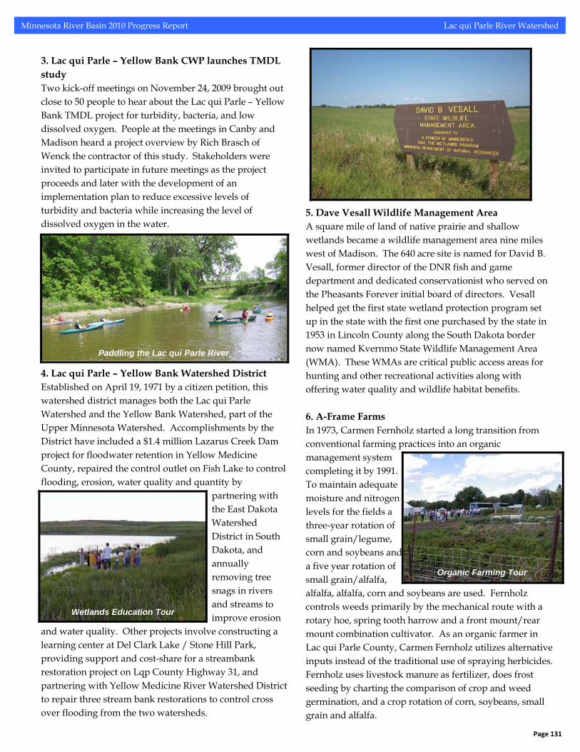
3. Lac qui Parle – Yellow Bank CWP launches TMDL study Two kick-off meetings on November 24, 2009 brought out close to 50 people to hear about the Lac qui Parle – Yellow Bank TMDL project for turbidity, bacteria, and low dissolved oxygen. People at the meetings in Canby and Madison heard a project overview by Rich Brasch of Wenck the contractor of this study. Stakeholders were invited to participate in future meetings as the project proceeds and later with the development of an implementation plan to reduce excessive levels of turbidity and bacteria while increasing the level of dissolved oxygen in the water. 4. Lac qui Parle – Yellow Bank Watershed District Established on April 19, 1971 by a citizen petition, this watershed district manages both the Lac qui Parle Watershed and the Yellow Bank Watershed, part of the Upper Minnesota Watershed. Accomplishments by the District have included a $1.4 million Lazarus Creek Dam project for floodwater retention in Yellow Medicine County, repaired the control outlet on Fish Lake to control flooding, erosion, water quality and quantity by
partnering with the East Dakota Watershed District in South Dakota, and annually removing tree snags in rivers and streams to improve erosion
and water quality. Other projects involve constructing a learning center at Del Clark Lake / Stone Hill Park, providing support and cost-share for a streambank restoration project on Lqp County Highway 31, and partnering with Yellow Medicine River Watershed District to repair three stream bank restorations to control cross over flooding from the two watersheds.
Wetlands Education Tour
Paddling the Lac qui Parle River
Minnesota River Basin 2010 Progress Report Lac qui Parle River Watershed
7. Nutrient and Greenhouse Gas Benefits As an organic farmer and conservationist, Carmen Fernholz plants radishes after harvesting his main crop for
nutrient benefits. Instead of applying commercial fertilizer the radishes decompose when temperatures start to rise in the
spring and slowly release nutrients into the soil. Planting radishes has another side benefit by offsetting climate change. Through photosynthesis, the radishes convert carbon dioxide, a greenhouse gas, into organic plant matter. When the radish dies and decomposes, the carbon in the plant also remains stored in the soil. Fernholz plants the radishes for the nutrient benefits but likes the idea of helping reduce greenhouse gases.
9. Lac qui Parle SWCD The Lac qui Parle Soil and Water Conservation District (SWCD) provides technical, financial and education resources to citizens, landowners and farmers in the county. Conservation practices installed with help from Lac qui Parle SWCD include terraces, water and sediment control basins, and grass waterways along with an active tree planting and living snow fence programs. Lac qui Parle SWCD conducts a variety of education programs for all age groups ranging from classroom and group presentations to workshops and organic farming tour. The Lac qui Parle SWCD partners with organizations like the Lac qui Parle – Yellow Bank CWP to promote conservation practices and work to improve water quality. One of the major projects involving the Lac qui Parle SWCD and other partners was the streambank stabilization at the County Highway 31 Bridge. After installing a series of stream barbs to divert flow back into
the river channel, re-sloping the bank, placing selective rip-rap, and seeding native plants, water clarity improved from transparency tube readings of 30s to almost 60 cm. The local paper ran a quote from a veteran paddler saying, “. . . the river was the clearest I have seen it in the last 10 years.”
County Highway 31 Bridge Project
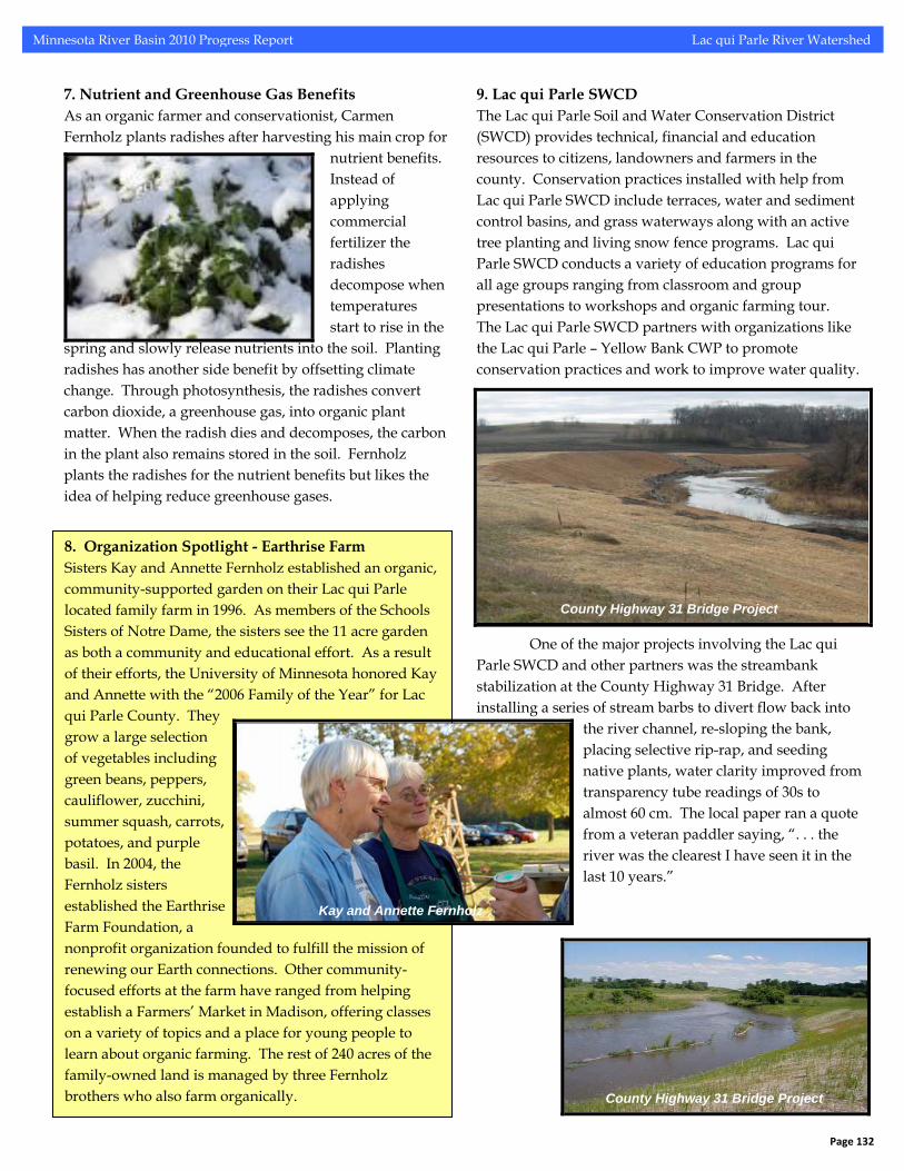
8. Organization Spotlight - Earthrise Farm Sisters Kay and Annette Fernholz established an organic, community-supported garden on their Lac qui Parle located family farm in 1996. As members of the Schools Sisters of Notre Dame, the sisters see the 11 acre garden as both a community and educational effort. As a result of their efforts, the University of Minnesota honored Kay and Annette with the “2006 Family of the Year” for Lac qui Parle County. They grow a large selection of vegetables including green beans, peppers, cauliflower, zucchini, summer squash, carrots, potatoes, and purple basil. In 2004, the Fernholz sisters established the Earthrise Farm Foundation, a nonprofit organization founded to fulfill the mission of renewing our Earth connections. Other community-focused efforts at the farm have ranged from helping establish a Farmers’ Market in Madison, offering classes on a variety of topics and a place for young people to learn about organic farming. The rest of 240 acres of the family-owned land is managed by three Fernholz brothers who also farm organically.
Kay and Annette Fernholz
County Highway 31 Bridge Project
Page 132
Minnesota River Basin 2010 Progress Report Lac qui Parle River Watershed
place with willow stakes. In the spring of 2009, necessary repair to the streambank project included reshaping and reseeding covered by erosion control blanket, a small amount of rock at the edge of the riprap, and dogwood and plum planted on the lower shelf.
After Restoration
10. Project Spotlight - Lac qui Parle County Highway 31 Project A streambank stabilization project was undertaken by a collection of partners along the Lac qui Parle River near a
county highway bridge. An existing CREP buffers did prevent cropland sediment from entering the river but 100 tons of soil per year were being added to the river from the
streambank. In addition, the stability of a county bridge was increasingly being threatened. The Lac qui Parle SWCD worked with Lac qui Parle County, DNR, NRCS, Lac qui Parle – Yellow Bank Watershed District and the Lac qui Parle Lake Association to stabilize the streambank
with a combination of stream barbs, selective riprap, and bank re-sloping with reseeding of native grasses protected by erosion control
nket held in
Before Restoration
bla
11. Lac qui Parle Outdoor Expo The first-ever Outdoor Expo held in Lac qui Parle County on April 28-29, 2007 attracted approximately 1,200 people to hear presentations by Tony Dean and James Meger among other topics. Lac qui Parle SWCD, Madison Chamber of Commerce, Lac qui Parle – Yellow Bank Clean Water Partnership and other partners hosted the event at the county fairgrounds. Other speakers gave presentations on topics like rain gardens, dog training and first aid, bird watching 101, healthy soil, healthy plants, healthy people along with outdoor activities including a kids fishing derby, archery and sporting clay shooting. The event focused on increasing awareness of relationships between people, wildlife and a healthy environment. 12. Killen Moist Soil Management Area The Lac qui Parle Wildlife Management Area is 33,000 acres of prime habitat for waterfowl and now on the cutting edge of a new look at the State of Minnesota’s vision for producing more ducks. Five years ago the DNR partnered with Ducks Unlimited to develop the Killen Moist Soil Unit. Named for Jim Killen, a wildlife artist, the unit cost $350,000 with a goal to mimic natural wet-and-dry cycles in order for vegetation like smartweed and pigeon grass to germinate before flooding the areas in the fall. The clean, clear, carp-free water and ample vegetation provide migrating waterfowl a place to feed and rest on their way south. Another 150 acres surround the unit serves as a buffer with no hunting allowed. To manage the water level a 1.7-mile dike was built and 65 to 100 million gallons of water pumped from Marsh Lake to flood the area. Cost to operate and maintain the site is about $34,000, partially paid out of duck stamp funds. Now the State of Minnesota has began to explore the idea of adding more of these “moist soil” management areas across the state.
Page 133
Information Booth at Expo
Minnesota River Basin 2010 Progress Report Lac qui Parle River Watershed
River Advocate – Dave Craigmile Dave Craigmile grew up on a farm near Boyd where he became interested in science as a young boy, including the study of geology, water and other physical properties in the environment around him. After graduating from college, Dave taught physical and earth science for seven years in the Osseo School District before going back into farming. Today, he raises traditional crops like wheat, soybeans and corn while being involved in a variety of water-related activities, everything from paddling to serving on the Lac qui Parle – Yellow Bank Watershed District board and volunteering as a citizen monitor. His strong interest in science and geology continues as Dave serves on the Minnesota River Turbidity TMDL stakeholder advisory committee and technical advisor for the Lac qui Parle – Yellow Bank Clean Water Partnership. On his free time, Dave spends a lot of time paddling the local rivers, especially the Lac qui Parle. You’ve got to understand the river to get in it or on it and that is why I’ve always enjoyed canoeing and later days, kayaking on a river. It gives you that seat of the pants feel for the river and you can feel the river moving under you. You can observe how the bars are forming in the river and you can certainly observe all the wildlife and the flora and fauna in general that are part of the river system. It’s always easy to look over the river bank and assume what’s going on, but it’s quite a bit more work to track it down and try to understand the issues that are involved behind it.
Dave Craigmile on the West Branch of the Lac qui Parle River
Dave Craigmile on the West Branch of the Lac qui Parle River
13. Dawson Dam Removal In the fall of 2009, the 1920-era low head dam in Dawson was removed by the Minnesota Department of Natural Resources (DNR) to allow for fish migration up the Lac qui Parle River and also provide a safer passage downstream for paddlers. A series of 15 rock weirs or steps built from boulders were put in place of the concrete structure. These pools will allow fish to migrate 60 miles upstream for the first time since the dam was built to provide ice for homes and businesses during the winter before electric power came to Dawson. The top rock weir is only six inches lower than the original height of the dam. According to DNR staff, the removal of dam will help with water quality issues including low dissolved oxygen levels in the Lac qui Parle River. There was also a lot of community support for the project and this should increase as the new set-up allows for better and safer public access to the river for both fishing and paddling.
Construction Rock Weirs on the Lac qui Parle River
Construction Rock Weirs on the Lac qui Parle River
Page 134
Minnesota River Basin 2010 Progress Report Lac qui Parle River Watershed
Lac qui Parle River Watershed Conservation Practices and Land Use
FEEDLOT POLLUTION REDUCTION
0% FILTER STRIP PROJECTS2%
GULLY STABILIZATION20%
OTHER CALCULATED POLLUTION REDUCTION
14%
SHEET/RILL AND EPHEMERAL CONTROL
13%
STREAM/DITCH BANK STABILIZATION
0%
WELL SEALING41%
WIND EROSION10%
Lac qui Parle River Major Watershed
Conservation Practices After the initiation of the Lac qui Parle – Yellow Bank Clean Water Partnership in 2001, the work of improving water quality began a few years later. The map to the left and the pie chart above illustrates conservation practices in the Lac qui Parle Watershed. The conservation practices data comes from the Board of Water and Soil Resources (BWSR) program compiles information on a county, watershed, and individual-project basis from 1997 to 2008. The number of conservation practices reflects only actual contract and not the acres. There are additional conservation practices installed in the Lac qui Parle River Watershed but not recorded in either LARS or eLINK.
Source: Minnesota Agricultural Statistics
Page 135
Minnesota River Basin 2010 Progress Report Lac qui Parle River Watershed
Lac qui Parle River Watershed Pollution Reduction
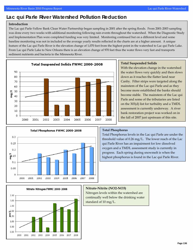
Introduction The Lac qui Parle-Yellow Bank Clean Water Partnership began sampling in 2001 after the spring floods. From 2001-2003 sampling was done every two weeks with additional monitoring following rain events throughout the watershed. When the Diagnostic Study and Implementation Plan were completed funding was very limited. Monitoring continued but on a different level and some baseline monitoring was not in included so the average yearly results reflected in the charts are at a higher amount. A unique feature of the Lac qui Parle River is the elevation change of 1,070 feet from the highest point in the watershed to Lac qui Parle Lake. From Lac qui Parle Lake to New Orleans there is an elevation change of 970 feet thus the water flows very fast and transports sediment nutrients and bacteria to the Minnesota River.
Total Suspended Solids With the elevation change in the watershed the water flows very quickly and then slows down as it reaches the flatter land near Canby. Filter strips were targeted along the mainstem of the Lac qui Parle and as they become more established the banks should become stable. The mainstem of the Lac qui Parle and some of the tributaries are listed on the 303(d) list for turbidity and a TMDL assessment is currently underway. A river bank restoration project was worked on in the fall of 2007 just upstream of this site.
Total Phosphorus Total Phosphorus levels in the Lac qui Parle are under the threshold value of 0.26 mg/L. The lower reach of the Lac qui Parle River has an impairment for low dissolved oxygen and a TMDL assessment study is currently in progress. Each spring during snowmelt is when the highest phosphorus is found in the Lac qui Parle River.
Nitrate-Nitrite (NO2-NO3) Nitrogen levels within the watershed are continually well below the drinking water standard of 10 mg/L.