Office: 850.981.7000 | Fax: 850.983.9874 | www.santarosa.fl.gov Rev 1.7.2021 SANTA ROSA COUNTY DEVELOPMENT SERVICES – Planning & Zoning 6051 Old Bagdad Highway, Suite 202| Milton, Florida 32583 SHAWN WARD, AICP Planning Director [email protected]Access Management Application Instructions: 1. Complete application and submit along with the following: a. A copy of the site plan (plot plan or site layout) showing the location of all existing and proposed driveways, curb cuts and median openings within the minimum spacing distances specified for the roadway, to be measured from any property corner which is located along the right of way of the access management corridor. The following distances shall be noted: distance between driveways, corner clearance and median opening spacing. The posted speed limit for all roadway segments which abut the development parcel(s). If a direct connection is permitted to an access management roadway, single family residential or duplex development shall provide for a turnaround area. b. Included in the application package is a generic site plan (plot plan or site layout) that can be used to show location of all existing and proposed driveways, curb cuts and median openings within the minimum spacing distance specified for the roadway, distance between driveways, corner clearance, posted speed limit for all roadway segments which abut the development parcel. If a direct connection is permitted to an access management roadway, single family residential or duplex development shall provide for a turnaround area. 2. A sample site plan ( plot plan or site layout) is included in the application package. The sample site plan (plot plan or site layout) shows what is required to be shown. 3. The application package includes excerpts from the Santa Rosa County Land Development Code Chapter 4, Section 4.05.00 and the list of Santa Rosa County Access Management Roads. 4. A Copy of this approved form must be submitted to the Public Works Department prior to issuance of any driveway permits. Land Development Code Excerpts: 4.05.00 ACCESS MANAGEMENT STANDARDS 4.05.01 Generally No Access Connection shall be constructed on any public road without a permit issued by Santa Rosa County pursuant to this section. Requirements for review are established in Chapter 11. 4.05.02 Access Management A. Legislative Intent – The purpose of this section is to provide and manage access to land development, while preserving the regional flow of traffic in terms of safety, capacity and speed. Major thoroughfares, including highways and other arterials serve as the primary network for moving people and goods. These transportation corridors provide access to businesses and dwellings and have served as the focus for commercial and residential development. If access systems are not properly regulated, these thoroughfares will be unable to accommodate the access needs of development and retain their primary transportation function. This ordinance balances the right of reasonable access to private property, with the right of the citizens of Santa Rosa County and the State of Florida to safe and efficient travel. B. Access Standards and Permitting – The following standards shall apply to all properties fronting on roadways that have been assigned an access management corridor designation shall be entitled to reasonable access to public thoroughfares. “Reasonable access” means the minimum number of connections necessary to provide safe and efficient ingress and egress to the roadway. All lots of record or parcels subject to a contract for deed or purchase, as of the respective effective date of this Section, and fronting on those thoroughfares designated in the above table, shall be entitled one (1) driveway/connection
Instructions: 1. Complete application and submit along with the following: a. A copy of the site plan (plot plan or site layout) showing the location of all existing and proposed driveways, curb cuts
and median openings within the minimum spacing distances specified for the roadway, to be measured from any property corner which is located along the right of way of the access management corridor. The following distances shall be noted: distance between driveways, corner clearance and median opening spacing. The posted speed limit for all roadway segments which abut the development parcel(s). If a direct connection is permitted to an access management roadway, single family residential or duplex development shall provide for a turnaround area.
b. Included in the application package is a generic site plan (plot plan or site layout) that can be used to show location
of all existing and proposed driveways, curb cuts and median openings within the minimum spacing distance specified for the roadway, distance between driveways, corner clearance, posted speed limit for all roadway segments which abut the development parcel. If a direct connection is permitted to an access management roadway, single family residential or duplex development shall provide for a turnaround area.
2. A sample site plan ( plot plan or site layout) is included in the application package. The sample site plan (plot plan or site
layout) shows what is required to be shown. 3. The application package includes excerpts from the Santa Rosa County Land Development Code Chapter 4, Section 4.05.00
and the list of Santa Rosa County Access Management Roads. 4. A Copy of this approved form must be submitted to the Public Works Department prior to issuance of any driveway
permits. Land Development Code Excerpts: 4.05.00 ACCESS MANAGEMENT STANDARDS 4.05.01 Generally No Access Connection shall be constructed on any public road without a permit issued by Santa Rosa County pursuant to this section. Requirements for review are established in Chapter 11. 4.05.02 Access Management A. Legislative Intent – The purpose of this section is to provide and manage access to land development, while preserving the
regional flow of traffic in terms of safety, capacity and speed. Major thoroughfares, including highways and other arterials serve as the primary network for moving people and goods. These transportation corridors provide access to businesses and dwellings and have served as the focus for commercial and residential development. If access systems are not properly regulated, these thoroughfares will be unable to accommodate the access needs of development and retain their primary transportation function. This ordinance balances the right of reasonable access to private property, with the right of the citizens of Santa Rosa County and the State of Florida to safe and efficient travel.
B. Access Standards and Permitting – The following standards shall apply to all properties fronting on roadways that have been assigned an access management corridor designation shall be entitled to reasonable access to public thoroughfares. “Reasonable access” means the minimum number of connections necessary to provide safe and efficient ingress and egress to the roadway. All lots of record or parcels subject to a contract for deed or purchase, as of the respective effective date of this Section, and fronting on those thoroughfares designated in the above table, shall be entitled one (1) driveway/connection
per parcel on said public thoroughfare(s) unless side street access from a public right of way is attainable. For purposes of this section, contiguous lots under single ownership shall be considered a single parcel. Lot ownership shall be traced back to the effective date of this Section and if, under one ownership at any time since the effective date, those lots will only be entitled to the one (1) driveway connection. When a lot or parcel is subdivided, either as metes and bounds parcels or as a recorded plat, all access to newly created lots shall be internalized using a shared circulation system via the permitted access connection(s). The number of connections to the roadway shall be the minimum number necessary to provide reasonable access, not the maximum available for that frontage. The Planning Director may consider these factors in determining the need for multiple access connections for a development: 1) separation of standard vehicles from heavy trucks or emergency vehicles; 2) two one-way connections that in combination serve ingress and egress to the development; and 3) multiple connections enhance the safety of the abutting roadway and improve the on-site traffic circulation. Single family residential or duplex development, whether on existing lots of record or on newly created lots, shall provide for a turnaround area if a direct driveway connection is permitted to an access management roadway and deemed necessary by the local fire authority. All access to outparcels shall be as direct as possible, avoiding excessive movement across parking aisles and queuing across surrounding parking and driving aisles. Access points shall not be located on major access drive aisles. Outparcels shall be served by a private access and shall provide for joint and cross access, shared parking and pedestrian interconnectivity. In addition, the developer shall make improvements to common driveways in accordance with the development’s impact as needed. 1. Access Management System and Standards The following access management system has been developed for roadways under state and local jurisdiction.
a. Access management standards shall be applied in accordance with the functional classification of a roadway in the table 4.05.01.A b. The spacing requirements for driveway connections for parcels located on access management corridors will be as follows:
i. All roadways under State jurisdiction will meet the access management spacing requirements of the State of Florida and of Santa Rosa County. If the State of Florida requirements are less restrictive, then the requirements of Santa Rosa County may be waived at the discretion of the Planning Director and the County Engineer. ii. All roadways under County jurisdiction will meet the following spacing requirements:
Roadway Classification Connection Spacing (in feet) >45 mph <45 mph
Major/Minor Arterial 660 440
Major Collector 440 245
Minor Collector 300 185
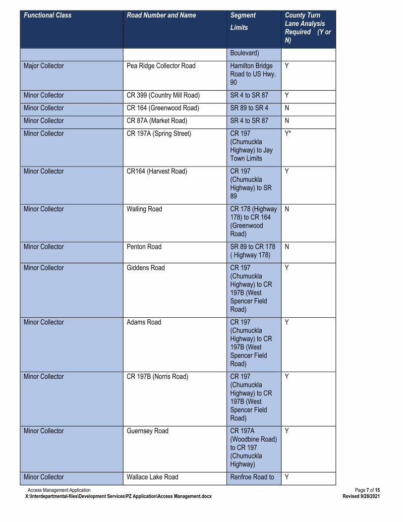
2. Connection spacing shall be measured from the closest edge of the pavement to the next closest edge of the pavement. Where construction plans are available for the widening, relocation, or other improvement is indicated in an adopted transportation plan or the Florida Department of Transportation Five Year Work Program, the projected future edge of the pavement of the intersecting road shall be used in measuring connection spacing. The access classification system and standards of the Florida Department of Transportation shall apply to all roadways on the State Highway System. The designated roadways as shown in the table below may be amended by resolution of the Board of County Commissioners. *Turn lane analysis required for portion inside the City Limits of Milton/Town Limits of Jay that is maintained by Santa Rosa County.
Functional Class Road Number and Name Segment Limits
County Turn Lane Analysis Required (Y or N)
Ortega Street
Minor Collector Granada Street US 98 to Laredo Street
N
Minor Collector Ortega Street US 98 to Laredo Street
Y
Minor Collector High School Boulevard SR 87S to Panhandle Trail
N
Minor Collector Panhandle Trail High School Boulevard to US 98
N
Minor Collector Audiss Road Old Bagdad Highway to Da Lisa Road
N
Minor Collector SA Jones Road US Hwy 90 to Bodega Dr
Y
Minor Collector Ten Mile Road Chumuckla Hwy to Wallace Lake Road
N
Minor Collector Tidwell Road Chumuckla Hwy to Willard Norris Road
N
3. Corner Clearance
a. New connections shall not be permitted within the functional area of an intersection or interchange. Where no other alternative accesses exist, such as joint use driveways or cross access, the Planning Director may allow construction of an access connection along the property line furthest from the intersection. In such cases, directional connections may be required. Site plans for developments which are located near intersections shall demonstrate the functional area of the intersection. b. In addition to the required minimum lot size, all corner lots created after the effective date of this Section shall be of adequate size to provide for required front yard setbacks and corner clearance on street frontage.
11.02.00 APPLICATION REQUIREMENTS 11.02.01 Submittal Requirements for All Applications A. Submittal requirements necessarily contemplate a wide variety of circumstances and it is understood that some information may be unnecessarily burdensome to produce.
1. A completed form provided by the Planning and Zoning Department. 2. Name, address, telephone number, email address and signature of the property owners; 3. When the applicant is a representative of the property owner, a statement acknowledged by the owners authorizing the representative to act as an agent of the property owner with regard to the application and associated procedures; 4. A sketch obtained no more than two (2) years prior to the filing of the application, containing the legal description, land area and existing improvements located on the site;
5. Written documentation that the property owner, has or will comply with all applicable notice requirements of this LDC; and 6. Payment of the required application fee.
11.02.02 Basic Submittal Requirements for Access Management, Coastal Construction, Parent Parcel, Itinerant Vendor, Major Land Clearing, Minor Land Clearing, Minor Subdivision, Off Premise Sign, PUD Master Plans, PBD Master Plans, PID Master Plans, Site Plan Applications, Tree Removal, Conditional Uses, Rezonings, Small Scale Future Land Use Amendments, Large Scale Future Land Use Amendments, Special Exceptions, and Variances A. Each application for Access Management, Coastal Construction, Parent Parcel, Itinerant Vendor, Major Land Clearing, Minor Land Clearing, Minor Subdivision, Off Premise Sign, PUD Master Plans, PBD Master Plans, PID Master Plans, Site Plan and Tree Removal Applications shall contain the following information: 1. All information required pursuant to section 11.02.01; 2. Name, address, telephone number and email address of the plan preparer; 3. Date of preparation and date(s) of any modifications of site plan, north arrow and written and graphic scale; 4. Legal description of the property, consistent with the survey, if a survey is required; 5. A vicinity map showing the location of the property; 6. Zoning designation for the property; 7. Additional plans, documents and reports as deemed necessary by the Planning Director; and 8. Information required for the specific type of application, as specified in sections 11.02.03 through 11.02.15, as applicable. B. All Site Plans, Plats and sketches of a Lot Split shall be drawn to a scale approved by the Planning Director. 11.02.03 Additional Submittal Requirements for Access Management A. All information required pursuant to section 11.02.02. B. A copy of the site plan (plot plan or site layout) showing the location of all existing and proposed driveways, curb cuts, and median openings with the minimum spacing distance specified for the roadway, to be measured from any property corner which is located along the right-of-way of the access management corridor. The following distances shall be noted: distance between driveways, corner clearance and median opening spacing. The posted speed limit for all roadway segments which abut the development parcel(s). If a direct connection is permitted to an access management roadway, single family residential or duplex development shall provide for a turnaround area. C. An application fee 11.04.00 GENERAL PROCEDURES 11.04.01 Determination of Completeness and Consistence with Regulations A. The Planning and Zoning Department shall provide notice via mail or electronic mail to the applicant within thirty (30) days
(except as provided below) of receipt of an application stating that the application is complete and that the proposed action complies with the applicable provisions of the Comprehensive Plan and LDC or stating with specificity any deficiencies which if cured, would make the application properly completed and in compliance with applicable regulations. Failure to timely provide such notices shall not be deemed an acknowledgement of completeness and consistency with applicable regulations.
B. The applicant shall have forty-five (45) days from the date of each notice to correct the deficiencies. Until the applicant corrects the deficiencies, the Departments will take not further action for processing the application. If the applicant fails to correct the deficiencies within the forty-five (45) day period, the application shall be deemed withdrawn.
C. Plans submitted in response to a notice specifying deficiencies shall be processed according to 10.05.01(A). The applicant shall then respond to any further notice by the Departments according to 10.05.01(B).
D. The Planning and Zoning Department shall process the application for review and action in accordance with the procedures applicable to that type of application as established.
a. The Planning and Zoning Department will review the application for completeness and if deemed complete will complete the review within ten (10) business days.
b. If the application is approved, a copy of the approval will be given to the applicant for submission to the Public Works Department prior to issuance of any driveway permits.
Application No. ________ -- AM -- ________ Date Received: _____________________ Review Fee: $100.00 Receipt No.: _____________________
Zoning District: _____________________ Roadway: ________________________ Property Owner Information: Property Owner Name: ______________________________________________________________________________________ Address: _________________________________________________________________________________________________ _________________________________________________________________________________________________________ Phone: ___________________________________________ Email: _________________________________________________ Applicant Information: Check here and skip this section if the applicant is the Property Owner. Otherwise, complete this section and provide authorization from the Property owner giving the Applicant the authority to pursue access management approvals. Company: _____________________________________________________________________________________________ Contact Name: _________________________________________________________________________________________ Address: ______________________________________________________________________________________________ ______________________________________________________________________________________________________ Phone: __________________________________________ Email: _______________________________________________ Project Information: Parcel ID Number(s): ___________________________________________________________________________________ --OR— Street Address of property for which the driveway permit is requested (if known): ____________________________________________________________________________________________________ Project Details: Are there existing driveways on this property? Yes No If yes, how many driveways are located on the property? ______________________________________________________ Are there any utilities (power poles – AT&T slick boxes) that may affect the location of the proposed driveways? Yes No
If yes, please indicate the location of the utilities on the included site plan. Please use the site plan on page 15 of this application to show the location of the proposed driveway and the dimensions from the edge of the driveway to the property lines, nearest driveways on the same side of the street and across the street. Staff Review: _______________________________ _____________________________________ Planning & Zoning Official Date _________________________________ Title Conditions or Comments: _________________________________________________________________________________ _______________________________________________________________________________________________________ _______________________________________________________________________________________________________ _______________________________________________________________________________________________________ _______________________________________________________________________________________________________ _______________________________________________________________________________________________________ _______________________________________________________________________________________________________ _______________________________________________________________________________________________________ Issuance of a development permit by the county does not in any way create any rights on the part of the applicant to obtain a permit from a state or federal agency and does not create any liability on the part of the county for issuance of the permit if the applicant fails to obtain requisite approvals or fulfill the obligations imposed by a state or federal agency or undertakes actions that result in a violation of state or federal law. This permit is conditioned is conditioned on obtaining all other applicable state or federal permits before commencement of the development.