We are committed to providing accessible customer service. If you need accessible formats or communications supports, please contact us. Nous tenons à améliorer l’accessibilité des services à la clientèle. Si vous avez besoin de formats accessibles ou d’aide à la communication, veuillez nous contacter. 1
Transcript
We are committed to providing accessible customer service.If you need accessible formats or communications supports, please contact us.
Nous tenons à améliorer l’accessibilité des services à la clientèle.Si vous avez besoin de formats accessibles ou d’aide à la communication, veuillez nous contacter.
APPENDIX A: STATEMENT OF QUALIFICATIONS APPENDIX B: THEORETICAL BASIS AND SURVEY PROCEDURES APPENDIX C: INSTRUMENT SPECIFICATIONS APPENDIX D: LIST OF MAPS (IN MAP POCKET)
LIST OF TABLES AND FIGURES
Figure 1: Location of the McAra Project ..................................................................... 3
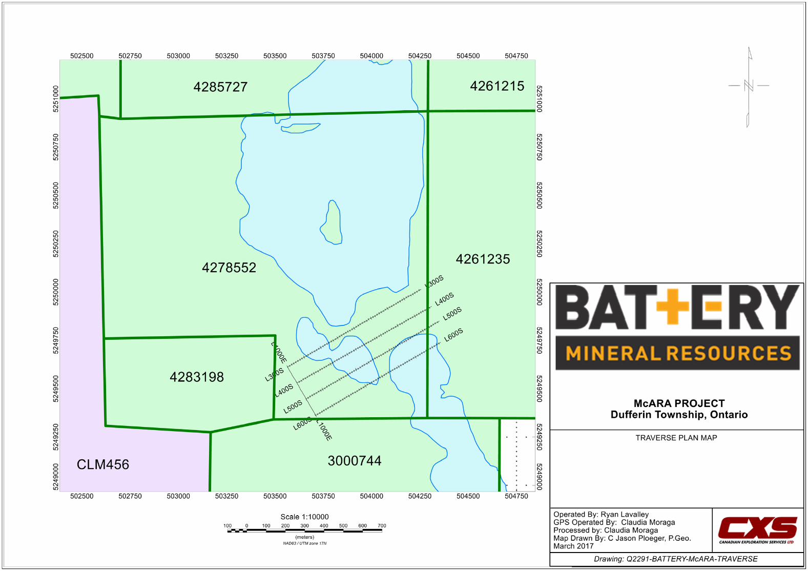
Figure 2: Claim Map with the McAra Traverses ......................................................... 4
Figure 3: Magnetometer Plan of McAra on Google Earth .......................................... 6
CANADIAN EXPLORATION SERVICES LIMITED PLAN-EXECUTE-DISCOVER-DEVELOP
Page 3
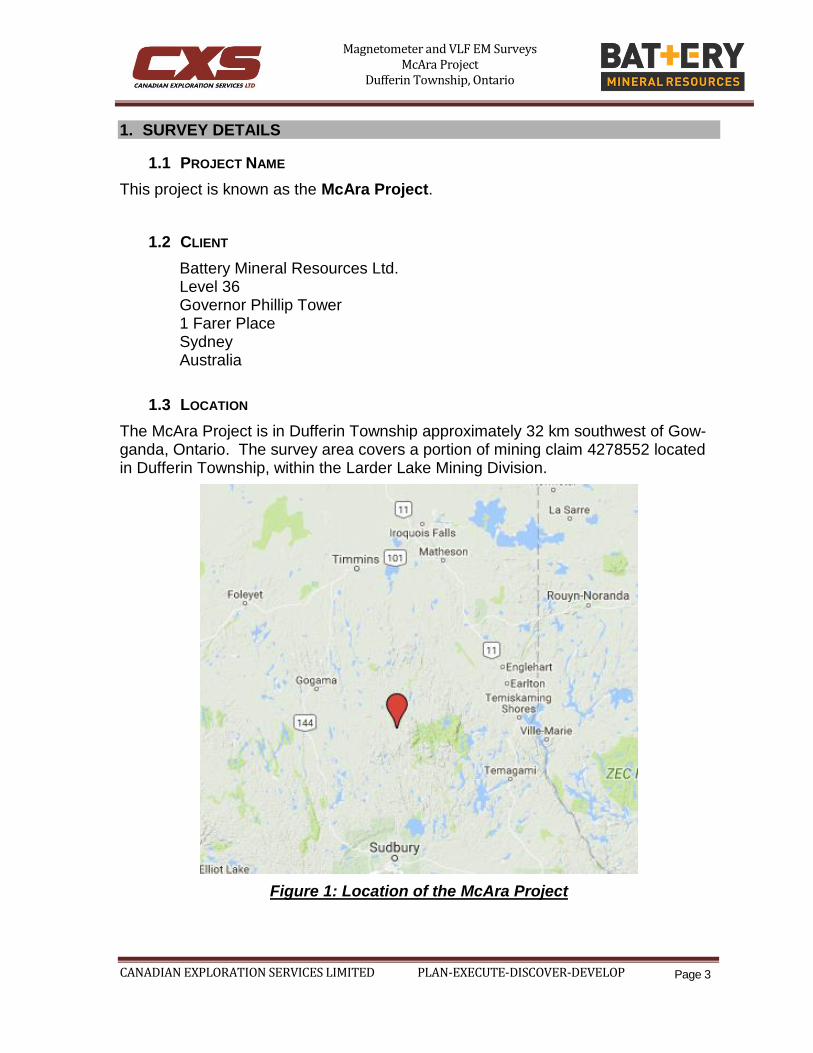
1. SURVEY DETAILS
1.1 PROJECT NAME
This project is known as the McAra Project.
1.2 CLIENT
Battery Mineral Resources Ltd. Level 36
Governor Phillip Tower 1 Farer Place Sydney Australia
1.3 LOCATION
The McAra Project is in Dufferin Township approximately 32 km southwest of Gow-ganda, Ontario. The survey area covers a portion of mining claim 4278552 located in Dufferin Township, within the Larder Lake Mining Division.
Figure 1: Location of the McAra Project
Magnetometer and VLF EM Surveys McAra Project
Dufferin Township, Ontario
CANADIAN EXPLORATION SERVICES LIMITED PLAN-EXECUTE-DISCOVER-DEVELOP
Page 4
1.4 ACCESS
Access to the property was attained with a 4x4 truck on the Beauty Lake Road. The Beauty Lake Road heads south from Hwy 560 approximately 23 kilometres west of Elk Lake, Ontario. The Beauty Lake Road was travelled for approximately 50 kilo-metres to the survey area.
1.5 SURVEY GRID
The traversed lines were established using a GPS in conjunction with the execution of the survey. The GPS operator would establish sample locations while remaining approximately 12.5m in front of the magnetometer/VLF EM operator. GPS way-points, magnetic and VLF EM samples were taken every 12.5m along these con-trolled traverses. The GPS used was a Garmin GPSMAP 62s with an external an-tenna for added accuracy.
Figure 2: Claim Map with the McAra Traverses
Magnetometer and VLF EM Surveys McAra Project
Dufferin Township, Ontario
CANADIAN EXPLORATION SERVICES LIMITED PLAN-EXECUTE-DISCOVER-DEVELOP
Page 5
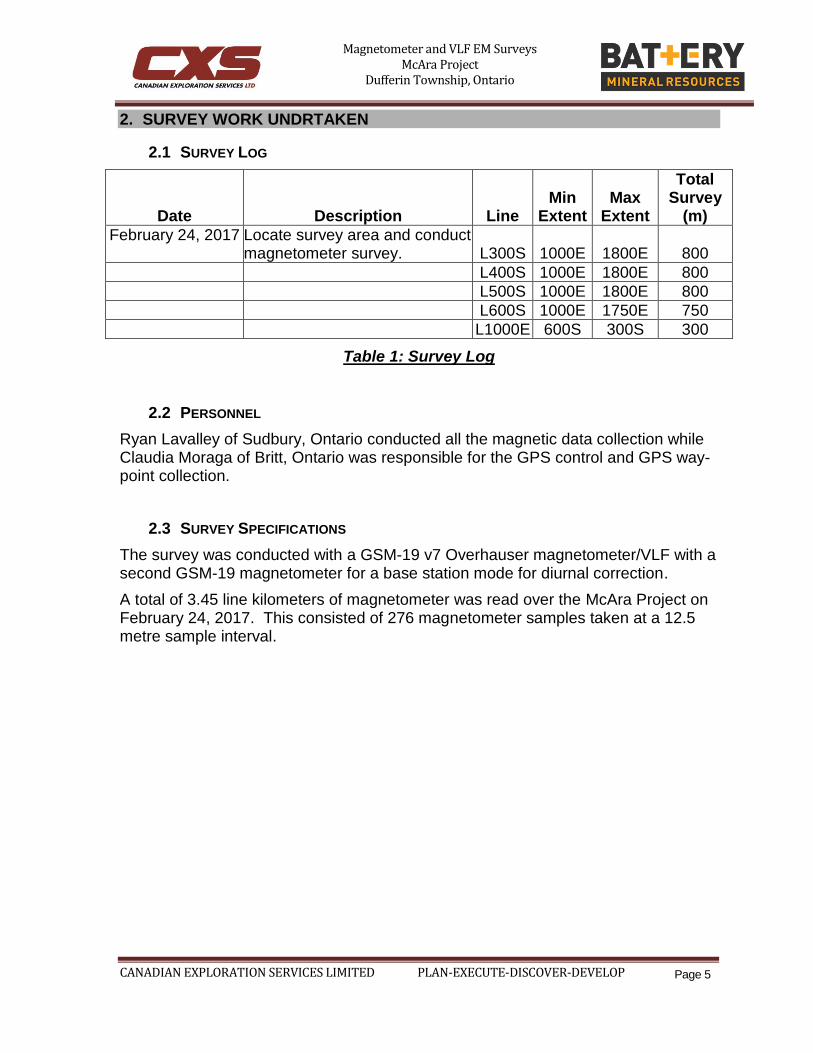
2. SURVEY WORK UNDRTAKEN
2.1 SURVEY LOG
Date Description Line Min
Extent Max
Extent
Total Survey
(m)
February 24, 2017 Locate survey area and conduct magnetometer survey. L300S 1000E 1800E 800
L400S 1000E 1800E 800
L500S 1000E 1800E 800
L600S 1000E 1750E 750
L1000E 600S 300S 300
Table 1: Survey Log
2.2 PERSONNEL
Ryan Lavalley of Sudbury, Ontario conducted all the magnetic data collection while Claudia Moraga of Britt, Ontario was responsible for the GPS control and GPS way-point collection.
2.3 SURVEY SPECIFICATIONS
The survey was conducted with a GSM-19 v7 Overhauser magnetometer/VLF with a second GSM-19 magnetometer for a base station mode for diurnal correction.
A total of 3.45 line kilometers of magnetometer was read over the McAra Project on February 24, 2017. This consisted of 276 magnetometer samples taken at a 12.5 metre sample interval.
Magnetometer and VLF EM Surveys McAra Project
Dufferin Township, Ontario
CANADIAN EXPLORATION SERVICES LIMITED PLAN-EXECUTE-DISCOVER-DEVELOP
Page 6
3. OVERVIEW OF SURVEY RESULTS
3.1 SUMMARY
Figure 3: Magnetometer Plan of McAra on Google Earth
No culture was noted through the traverse area.
A magnetically elevated unit can be observed over the western extent of the survey area. This unit appears to trend at 330 degrees and also appears to be truncated on the northern extent. The strike of the unit is similar to that expected with some re-gional diabase dykes. The truncation to the north is most likely a result of a struc-tural feature. This may have resulted in an alteration zone and may be a good target for further exploration.
Magnetometer and VLF EM Surveys McAra Project
Dufferin Township, Ontario
CANADIAN EXPLORATION SERVICES LIMITED PLAN-EXECUTE-DISCOVER-DEVELOP
Page 7
APPENDIX A
STATEMENT OF QUALIFICATIONS
I, C. Jason Ploeger, hereby declare that:
1. I am a professional geophysicist with residence in Larder Lake, Ontario and am presently employed as a Geophysicist and Geophysical Manager of Ca-nadian Exploration Services Inc. of Larder Lake, Ontario.
2. I am a Practicing Member of the Association of Professional Geoscientists, with membership number 2172.
3. I graduated with a Bachelor of Science degree in geophysics from the Univer-
sity of Western Ontario, in London Ontario, in 1999. 4. I have practiced my profession continuously since graduation in Africa, Bul-
garia, Canada, Mexico and Mongolia.
5. I am a member of the Ontario Prospectors Association, a Director of the Northern Prospectors Association and a member of the Society of Exploration Geophysicists.
6. I do not have nor expect an interest in the properties and securities of Battery
Mineral Resources.
7. I am responsible for the final processing and validation of the survey results and the compilation of the presentation of this report. The statements made in this report represent my professional opinion based on my consideration of the information available to me at the time of writing this report.
C. Jason Ploeger, P.Geo., B.Sc.
Geophysical Manager Canadian Exploration Services Inc.
Larder Lake, ON March 2nd, 2017
Magnetometer and VLF EM Surveys McAra Project
Dufferin Township, Ontario
CANADIAN EXPLORATION SERVICES LIMITED PLAN-EXECUTE-DISCOVER-DEVELOP
Page 8
APPENDIX B
THEORETICAL BASIS AND SURVEY PROCEDURES
TOTAL FIELD MAGNETIC SURVEY
Base station corrected Total Field Magnetic surveying is conducted using at least two synchronized magnetometers of identical type. One magnetometer unit is set in a fixed position in a region of stable geomagnetic gradient, and away from possible cultural effects (i.e. moving vehicles) to monitor and correct for daily diurnal drift. This magnetometer, given the term ‘base station’, stores the time, date and to-tal field measurement at fixed time intervals over the survey day. The second, re-mote mobile unit stores the coordinates, time, date, and the total field measurements simultaneously. The procedure consists of taking total magnetic measurements of the Earth’s field at stations, along individual profiles, including Tie and Base lines. A 2 meter staff is used to mount the sensor, in order to optimally minimize localized near-surface geologic noise. At the end of a survey day, the mobile and base-station units are linked, via RS-232 ports, for diurnal drift and other magnetic activity (ionospheric and sferic) corrections using internal software.
For the gradiometer application, two identical sensors are mounted vertically at the ends of a rigid fiberglass tube. The centers of the coils are spaced a fixed distance apart (0.5 to 1.0m). The two coils are then read simultaneously, which alleviates the need to correct the gradient readings for diurnal variations, to measure the gradient of the total magnetic field.
Magnetometer and VLF EM Surveys McAra Project
Dufferin Township, Ontario
CANADIAN EXPLORATION SERVICES LIMITED PLAN-EXECUTE-DISCOVER-DEVELOP
Page 9
APPENDIX C
GSM 19
Specifications
Overhauser Performance
Resolution: 0.01 nT Relative Sensitivity: 0.02 nT Absolute Accuracy: 0.2nT Range: 20,000 to 120,000 nT Gradient Tolerance: Over 10,000nT/m Operating Temperature: -40°C to +60°C
Operation Modes
Manual: Coordinates, time, date and reading stored automatically at min. 3 second interval. Base Station: Time, date and reading stored at 3 to 60 second intervals. Walking Mag: Time, date and reading stored at coordinates of fiducial. Remote Control: Optional remote control using RS-232 interface. Input/Output: RS-232 or analog (optional) output using 6-pin weatherproof connector.
Operating Parameters
Power Consumption: Only 2Ws per reading. Operates continuously for 45 hours on standby. Power Source: 12V 2.6Ah sealed lead acid battery standard, other batteries available Operating Temperature: -50°C to +60°C
Storage Capacity
Manual Operation: 29,000 readings standard, with up to 116,000 optional. With 3 VLF stations: 12,000 standard and up to 48,000 optional.
Base Station: 105,000 readings standard, with up to 419,000 optional (88 hours or 14 days uninterrupted operation with 3 sec. intervals)
Gradiometer: 25,000 readings standard, with up to 100,000 optional. With 3 VLF stations: 12,000, with up to 45,000 optional.
Magnetometer and VLF EM Surveys McAra Project
Dufferin Township, Ontario
CANADIAN EXPLORATION SERVICES LIMITED PLAN-EXECUTE-DISCOVER-DEVELOP
Page 10
Omnidirectional VLF
Performance Parameters: Resolution 0.5% and range to ±200% of total field. Frequency 15 to 30 kHz.
Measured Parameters: Vertical in-phase & out-of-phase, 2 horizontal compo-nents, total field coordinates, date, and time.
Features: Up to 3 stations measured automatically, in-field data review, dis-plays station field strength continuously, and tilt correction for up to ±10° tilts.
Dimensions and Weights: 93 x 143 x 150mm and weighs only 1.0kg.
Dimensions and Weights
Dimensions: Console: 223 x 69 x 240mm Sensor: 170 x 71mm diameter cylinder Weight: Console: 2.1kg Sensor and Staff Assembly: 2.0kg
Standard Components
GSM-19 magnetometer console, harness, battery charger, shipping case, sensor with cable, staff, instruction manual, data transfer cable and software.
Taking Advantage of a “Quirk” of Physics
Overhauser effect magnetometers are essentially proton precession devices except that they produce an order-of magnitude greater sensitivity. These "supercharged" quantum magnetometers also deliver high absolute accuracy, rapid cycling (up to 5 readings / second), and exceptionally low power consumption.
The Overhauser effect occurs when a special liquid (with unpaired electrons) is combined with hydrogen atoms and then exposed to secondary polarization from a radio frequency (RF) magnetic field. The unpaired electrons transfer their stronger polarization to hydrogen atoms, thereby generating a strong precession signal-- that is ideal for very high-sensitivity total field measurement. In comparison with proton precession methods, RF signal generation also keeps power consumption to an ab-solute minimum and reduces noise (i.e. generating RF frequencies are well out of the bandwidth of the precession signal).
In addition, polarization and signal measurement can occur simultaneously - which enables faster, sequential measurements. This, in turn, facilitates advanced statisti-cal averaging over the sampling period and/or increased cycling rates (i.e. sampling speeds).
The unique Overhauser unit blends physics, data quality, operational efficien-cy, system design and options into an instrumentation package that ... ex-
Magnetometer and VLF EM Surveys McAra Project
Dufferin Township, Ontario
CANADIAN EXPLORATION SERVICES LIMITED PLAN-EXECUTE-DISCOVER-DEVELOP
Page 11
ceeds proton precession and matches costlier optically pumped cesium ca-pabilities
Magnetometer and VLF EM Surveys McAra Project
Dufferin Township, Ontario
CANADIAN EXPLORATION SERVICES LIMITED PLAN-EXECUTE-DISCOVER-DEVELOP
Page 12
APPENDIX C
GARMIN GPS MAP 62S
Physical & Performance:
Unit dimensions,
WxHxD: 2.4" x 6.3" x 1.4" (6.1 x 16.0 x 3.6 cm)
Display size, WxH: 1.43" x 2.15" (3.6 x 5.5 cm); 2.6" diag (6.6 cm)
Display resolution,
WxH: 160 x 240 pixels
Display type: transflective, 65-K color TFT
Weight: 9.2 oz (260.1 g) with batteries
Battery: 2 AA batteries (not included); NiMH or Lithium recom-
mended
Battery life: 20 hours
Waterproof: yes (IPX7)
Floats: no
High-sensitivity re-
ceiver: yes
Magnetometer and VLF EM Surveys McAra Project
Dufferin Township, Ontario
CANADIAN EXPLORATION SERVICES LIMITED PLAN-EXECUTE-DISCOVER-DEVELOP
Page 13
Interface: high-speed USB and NMEA 0183 compatible