Banyule Wildlife Corridor Program CONTENTS ACKNOWLEDGEMENTS 3 MAP 4 OVERVIEW 5 INTRODUCTION 6 Why are wildlife corridors important? 6 Banyule’s natural habitats 7 Waterways 7 Wetlands 8 River Red Gum Woodlands 8 Bushland Remnants 9 Maintaining and establishing wildlife corridors in Banyule 10 Role of Council and the community 11 BANYULE’S WILDLIFE CORRIDORS 13 Identifying Banyule’s Wildlife Corridors 13 Yarra River - Major Wildlife Corridor 14 Yarra Catchment - Local Habitat Links 16 Salt Creek Link 16 Banyule Creek Link 17 Ivanhoe Valley Link 18 Plenty River - Major Wildlife Corridor 19 Plenty Catchment – Local Habitat Links 21 Yallambie Creek Link 21 Northern Foothills Link 22 Greensborough Valley Link 24 Sweetwater Creek Link 25 Darebin Creek - Major Wildlife Corridor 26
Transcript
Banyule Wildlife Corridor Program 1
CONTENTS ACKNOWLEDGEMENTS 3 MAP 4 OVERVIEW 5 INTRODUCTION 6 Why are wildlife corridors important? 6 Banyule’s natural habitats 7 Waterways 7 Wetlands 8 River Red Gum Woodlands 8 Bushland Remnants 9 Maintaining and establishing wildlife corridors in Banyule 10 Role of Council and the community 11 BANYULE’S WILDLIFE CORRIDORS 13 Identifying Banyule’s Wildlife Corridors 13 Yarra River - Major Wildlife Corridor 14 Yarra Catchment - Local Habitat Links 16 Salt Creek Link 16 Banyule Creek Link 17 Ivanhoe Valley Link 18 Plenty River - Major Wildlife Corridor 19 Plenty Catchment – Local Habitat Links 21 Yallambie Creek Link 21 Northern Foothills Link 22 Greensborough Valley Link 24 Sweetwater Creek Link 25 Darebin Creek - Major Wildlife Corridor 26
2 Banyule Wildlife Corridor Program
Darebin Catchment - Local Habitat Links 28 Donaldson’s Creek Link 28 Darebin Catchment - Potential Habitat Links 29 West Heidelberg Industrial Estate 29 Southern Road Link 29 Banksia Street Link 29 Connecting the Major Wildlife Corridors 31 Yallambie-Bundoora Plains Link 31 Railway Link 32 Powerline Link 33 Other potential habitat links 33 DEVELOPING BANYULE’S WILDLIFE 34 CORRIDOR PROGRAM Aims and objectives 34 Action plan 35 Protecting vegetation and habitat remnants 35 Revegetation and habitat restoration 39 Re-establishing habitat on private land 41 Community awareness and program promotion 42 Attracting resources 45 Coordination and monitoring progress 45 PROGRAM IMPLEMENTATION 48 Implementation schedule 48 Financial requirements 51 REFERENCES AND FURTHER READING 52 Appendix 1 Sites of Environmental Significance 55 Appendix 2 Community Group Contacts 59
Banyule Wildlife Corridor Program 3
ACKNOWLEDGMENTS The development of the Banyule Wildlife Corridor Program follows an initial study and the production of a poster undertaken by the Banyule Council in conjunction with Greening Australia (Victoria). Thanks to James Gillespie, Judy Spittle and Guy Pritchard from Greening Australia for their involvement. A number of staff from the Banyule Council and others have provided helpful comments and been involved with the ongoing development of the program. They particularly include Pat Vaughan (Environment Planner), Jon Brock (Manager Strategic & Economic Development), Ann Cremean (Plenty/Yarra River Coordinator) and Janine Nechwatal (Darebin Creek Coordinator). Thanks also to members of the Banyule Environment Advisory Committee for contributing to the development of the action plan. Report prepared by Rik Brown – Botanical Consultant for the Banyule City Council, Victoria Adopted by Council March 2000 (Minor corrections have been made to this edition - May 2003)
4 Banyule Wildlife Corridor Program
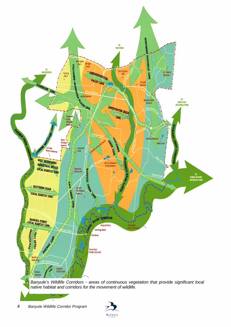
Banyule’s Wildlife Corridors - areas of continuous vegetation that provide significant local native habitat and corridors for the movement of wildlife.
Banyule Wildlife Corridor Program 5
OVERVIEW Many areas of natural habitat occur within Banyule and nearby providing important refuges for indigenous, or local native, plants and animals. Over time, clearing for agriculture followed by urban development has resulted in a substantial fragmentation of natural habitat. This has contributed to a decline in local biodiversity and places ongoing pressure on remaining habitat. Wildlife corridors provide links between fragmented and otherwise isolated areas of natural habitat. They play a key role in providing for the ecological sustainability of Banyule’s natural environment by allowing for the movement and dispersal of indigenous animals and plants. Major Wildlife Corridors identified incorporate the extensive networks of parklands and reserves along the Yarra River, Plenty River and Darebin Creek. These form important strategic links between areas of natural habitat within and near Banyule. They also extend throughout the region to the north-east of Melbourne. A number of Local Habitat Links between areas of natural habitat have also been identified within Banyule. They include substantial residential areas throughout much of the municipality, which either contain remnant indigenous vegetation, or are of importance because of their location between sites of environmental significance. The Banyule Wildlife Corridor Program aims to protect and re-establish wildlife corridors and habitat links within Banyule which allow for the movement and dispersal of native animals and plants. A plan of actions had been developed incorporating strategies to: • protect indigenous vegetation and natural habitat remnants throughout Banyule, • undertake revegetation and habitat restoration activities within the wildlife corridors
and habitat links identified, and • encourage the re-establishment of habitat on private land within and adjacent to
wildlife corridors. The program is intended to provide a key focus for revegetation and habitat restoration activities undertaken within Banyule by Council, other organisations and the local community. Major components will include campaigns to increase community awareness and involvement in protecting and re-establishing wildlife corridors, such as through the provision of incentives, indigenous plant giveaways, educational activities and media promotions. A property registration scheme will be developed to recognise and encourage the involvement of private landholders, schools and other organisations participating in the Banyule Wildlife Corridor Program. Requirements for the coordination and resourcing of the program over an initial five-year period have been identified. The development and implementation of the Banyule Wildlife Corridor Program is a major initiative under Banyule’s Environment Policy and Strategy.
6 Banyule Wildlife Corridor Program
INTRODUCTION Why are wildlife corridors important? There are many areas of natural habitat located within and close to Banyule, which provide important refuges for indigenous, or local native, plants and animals. They occur in the extensive networks of parks and reserves throughout the municipality and also incorporate predominantly residential areas which continue to support remnants of the indigenous vegetation which previously occurred throughout the area. Over time, the clearing of land for agriculture, followed by encroaching suburbia, has substantially reduced the cover of indigenous vegetation resulting in a fragmentation of natural habitat areas. One of the main effects of habitat fragmentation is the creation of barriers preventing the movement and dispersal of animals and plants between natural habitat areas. The barriers may include physical structures, such as buildings or roads, or simply arise through the removal of indigenous vegetation which previously contributed to the continuity of habitat. The animals and plants effectively become trapped in “habitat islands” which are often of insufficient size for many species to survive within on a sustainable basis. Populations may decline in isolated habitat areas through disturbance, predation, over-competition for limited resources, or combinations of these. While the impacts of habitat fragmentation vary according to the requirements of individual species, the inevitable outcome is for a decline in the biodiversity of any particular region in which it occurs.
Wildlife corridors are strips of habitat linking one or more areas of isolated habitat and allowing for the movement and dispersal of animals and plants. They may also occur as separate patches of habitat, located in positions of strategic importance for particular species and effectively forming stepping-stones or resting sites for their movement and dispersal between more extensive habitat areas. Wildlife corridors play a vital role in providing for the ongoing viability of otherwise isolated areas of natural habitat and the animals and plants which depend on the habitat for their survival. Key functions of wildlife corridors and habitat links include: § allowing for the movement of animals, including mammals, birds, reptiles and insects,
between natural habitat areas, § providing a mechanism for the dispersal of plant seeds and spores, § maintaining the biodiversity of the local area, § assisting in maintaining the genetic diversity and viability of plant and animal
populations, § helping to reduce the competitive impacts of introduced plants and animals on
particular species, § providing temporary feeding sites and shelter for nomadic and migratory animals,
and, § enabling the return of plants and animals that may have become locally extinct.
Wildlife corridors, or habitat links, allow for the movement and dispersal of indigenous animals and plants between fragmented or otherwise isolated areas of natural habitat.
Banyule Wildlife Corridor Program 7
Banyule’s natural habitats
The natural habitats occurring within Banyule include waterways, wetlands associated with their flood plains, and a variety of indigenous forest and woodland vegetation communities scattered throughout the municipality. While the most significant habitats for indigenous plants and animals are generally located within parks and reserves, their size and values are enhanced where they extend into adjoining residential areas, particularly where a good cover of indigenous vegetation remains. Waterways The Yarra River, Plenty River and Darebin Creek are three major waterways providing important habitat for many of the indigenous plants and animals occurring within Banyule. The virtually continuous networks of parks and reserves extending along their lengths support substantial areas of indigenous vegetation. Many birds and mammals, including bats, possums, native water rats and wombats, utilise the indigenous vegetation and habitat adjacent to the waterways for feeding, breeding and shelter. The size and continuity of natural habitat areas extending along the Yarra River and Plenty River are of significance locally and regionally. Good examples of the indigenous vegetation characteristic of the Yarra River particularly occur at Wilson Reserve in Ivanhoe, providing feeding habitat and nesting sites for a diverse range of the birds found along the river. The Plenty River flows through the centre of Banyule and indigenous vegetation remains along much of its length, providing virtually continuous habitat for a diverse range of forest birds. Rocky escarpments along the Plenty River and Darebin Creek support a number of uncommon plants and provide habitat for lizards, while platypus have been recorded along the Plenty and Yarra Rivers. The Darebin Parklands in Ivanhoe incorporate remnants of indigenous vegetation and natural habitat along Darebin Creek. While much of the habitat elsewhere along the Darebin Creek has previously been modified, substantial habitat is now provided for birds by the indigenous vegetation that has been re-established along its length. Other waterways occurring within Banyule continuing to support habitat remnants include Salt Creek, Donaldson’s Creek, Banyule Creek, Yallambie Creek
and Sweetwater Creek.
Platypus, Plenty River Gary French
Blue Tongue Lizard Gary French
Royal Spoonbill Robert Bender
Spotted Marsh Frog Peter Robertson
8 Banyule Wildlife Corridor Program
Wetlands Wetlands within Banyule provide habitat for a diverse range of plants and animals whose habitat has largely been depleted elsewhere in the region around Melbourne. They include a variety of waterbirds, such as pelicans, spoonbills, herons, ducks and crakes. Many waterbirds rely on wetlands in the local area when conditions are less favourable at more extensive wetland areas further inland. Latham’s Snipe is an example of an international migratory wader, visiting wetlands along the Yarra River following breeding around Japan.
The wetlands also support a variety of aquatic plants, provide important habitat for frogs and are breeding sites for freshwater fish. The Yarra River flood plain incorporates a number of important wetlands. Within Banyule, these include the Banyule Flats wetlands, Warringal Swamplands and a number of billabongs within Yarra Flats Park and around Wilson Reserve. Additional wetland areas occur or have been re-established along the Plenty River, Darebin Creek and at Binnak Park in Watsonia. River Red Gum Woodlands
Woodlands characterised by the presence of River Red Gums are features of the indigenous vegetation remaining within Banyule. Many of the older trees contain natural hollows which provide habitat for a range of birds and other animals which rely on them for shelter and nesting sites, including parrots, owls, bats, possums and sugar gliders. Some of the oldest trees are considered to be over 600 years old. The River Red Gums provide feeding habitat for many birds, including honeyeaters and parrots, which feed on nectar from their flowers, insects in their foliage and also on their seeds. Where indigenous understorey vegetation has not been disturbed, it supports a variety of native grasses, lilies and herbs, and provides habitat for small ground-dwelling animals such as lizards.
River Red Gum Woodlands occur across the Yarra River flood plain and extend into the Lower Plenty area. The Simpson Army Barracks in Watsonia retains substantial River Red Gum Woodland areas and remnant trees are scattered over residential areas in the western half of Banyule, particularly within Macleod, Watsonia and Yallambie. Examples of old specimens of River Red Gum are found along the Yarra River and at Binnak Park in Watsonia, while Harry Pottage Reserve in Macleod includes areas with remnant understorey vegetation.
River Red Gums at Banyule Flats
Powerful Owl Anthea Fleming
White Striped Freetail Bat Lindy Lumsden
Banyule Wildlife Corridor Program 9
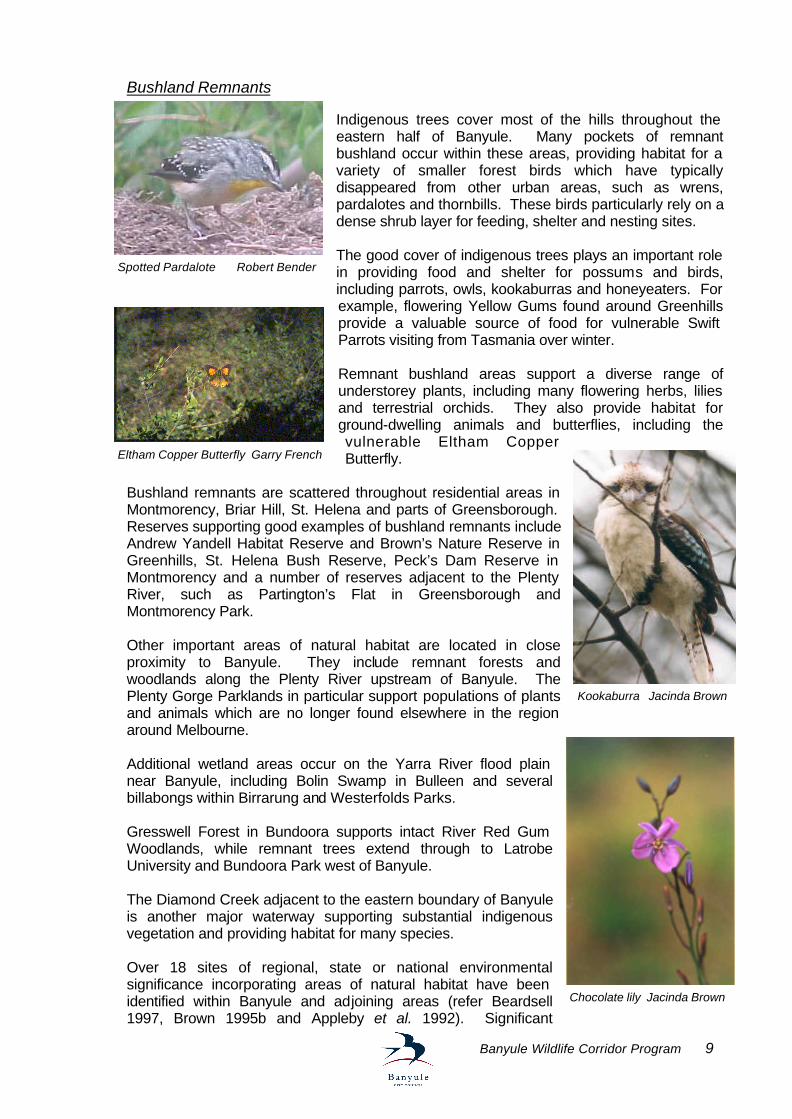
Bushland Remnants
Indigenous trees cover most of the hills throughout the eastern half of Banyule. Many pockets of remnant bushland occur within these areas, providing habitat for a variety of smaller forest birds which have typically disappeared from other urban areas, such as wrens, pardalotes and thornbills. These birds particularly rely on a dense shrub layer for feeding, shelter and nesting sites. The good cover of indigenous trees plays an important role in providing food and shelter for possums and birds, including parrots, owls, kookaburras and honeyeaters. For example, flowering Yellow Gums found around Greenhills provide a valuable source of food for vulnerable Swift Parrots visiting from Tasmania over winter. Remnant bushland areas support a diverse range of understorey plants, including many flowering herbs, lilies and terrestrial orchids. They also provide habitat for ground-dwelling animals and butterflies, including the vulnerable Eltham Copper Butterfly.
Bushland remnants are scattered throughout residential areas in Montmorency, Briar Hill, St. Helena and parts of Greensborough. Reserves supporting good examples of bushland remnants include Andrew Yandell Habitat Reserve and Brown’s Nature Reserve in Greenhills, St. Helena Bush Reserve, Peck’s Dam Reserve in Montmorency and a number of reserves adjacent to the Plenty River, such as Partington’s Flat in Greensborough and Montmorency Park. Other important areas of natural habitat are located in close proximity to Banyule. They include remnant forests and woodlands along the Plenty River upstream of Banyule. The Plenty Gorge Parklands in particular support populations of plants and animals which are no longer found elsewhere in the region around Melbourne. Additional wetland areas occur on the Yarra River flood plain near Banyule, including Bolin Swamp in Bulleen and several billabongs within Birrarung and Westerfolds Parks. Gresswell Forest in Bundoora supports intact River Red Gum Woodlands, while remnant trees extend through to Latrobe University and Bundoora Park west of Banyule. The Diamond Creek adjacent to the eastern boundary of Banyule is another major waterway supporting substantial indigenous vegetation and providing habitat for many species. Over 18 sites of regional, state or national environmental significance incorporating areas of natural habitat have been identified within Banyule and adjoining areas (refer Beardsell 1997, Brown 1995b and Appleby et al. 1992). Significant
Spotted Pardalote Robert Bender
Eltham Copper Butterfly Garry French
Kookaburra Jacinda Brown
Chocolate lily Jacinda Brown
10 Banyule Wildlife Corridor Program
Many more sites supporting indigenous vegetation and natural habitat of at least local environmental significance occur within Banyule. They incorporate many smaller reserves scattered throughout the municipality, several creeks and substantial residential areas supporting indigenous trees and understorey vegetation remnants (refer Brown 1995b & 1995c, Appleby et al. 1992 and Warringal Conservation Society 1981). Maintaining and establishing wildlife corridors in Banyule
Natural habitats formerly occurring throughout Banyule have become fragmented over time with the residential development of the region. While Banyule is now predominantly an urban municipality, there are many opportunities for protecting and enhancing the local environment which offer benefits for wildlife and the overall landscape amenity of the area. Maintaining and establishing wildlife corridors is fundamental to providing for the sustainability of Banyule’s remaining natural habitats and assisting in the ongoing survival of local plants and animals. The networks of reserves and parklands along the major waterways, the Yarra River, Plenty River and Darebin Creek, allow for the movement and dispersal of a diverse range of indigenous animals and plants because of their extent and continuity. This potentially includes allowing for the movement of ground-dwelling animals, such as kangaroos, wombats, native water rats and lizards, which would otherwise be unlikely to occur within urban areas.
The waterways provide a major focus for the movement of birds, such as honeyeaters, parrots, waterbirds and a range of forest species, which move over an extensive area in accordance with season and food availability. Platypus, native fish and frogs are particularly dependent on the waterways and associated wetland habitat for their survival locally. The effectiveness of the major waterways as wildlife corridors essentially relies on providing appropriate protection for indigenous vegetation and natural habitat areas along their length and enhancing areas where habitat is fragmented.
Biodiversity profile Indigenous, or local native, plants and animals recorded within Banyule and the immediate area include over 300 vascular plant species and 270 vertebrate animal species (refer Brown 1996a & 1995a). The indigenous animal species include 214 birds, 20 mammals, 23 reptiles, 12 frogs and 9 freshwater fish. The number of invertebrates occurring locally is not known, although it is likely to exceed 1,000 species and include at least 20 species of butterfly. Numbers of non-vascular plants, such as mosses, algae and lichens, and also fungi occurring locally are similarly poorly known.
Remnant Roadside Yellow Gums, Greensborough
Red Gums, Macleod
Banyule Wildlife Corridor Program 11
The remnant indigenous vegetation and natural habitats scattered throughout residential areas of Banyule are of equal importance for many species of indigenous plants and animals. The ability for birds and possums to move between habitat areas, in particular, is critical for them to find sufficient food and maintain population levels. Exploitative species, such as Common Starlings and Mynahs, often occupy isolated areas to the exclusion of indigenous species where the availability of suitable natural habitat is insufficient. The physical barriers within Banyule’s residential areas, including buildings and roads, present some obvious restrictions on the movement of some animals, such as kangaroos and wombats. There are, however, many opportunities to provide and enhance links suitable for birds, possums, bats and lizards by integrating the retention and restoration of natural habitat with urban development. The planting of indigenous plants within residential properties, reserves and along roadsides are of particular benefit. Maintaining and establishing wildlife corridors which provide for the ongoing natural regeneration of indigenous plant populations and the movement of native insects are key components in the effective functioning of natural ecosystems throughout the municipality. Role of Council and the community The Banyule Council plays a key role in overseeing the management of natural habitat areas on both public and private land throughout the municipality. Apart from directly managing many of the parks, roadsides and other reserves within Banyule, the ongoing development of private land is largely governed by the Banyule Planning Scheme administered by Council. The Council also works closely with other organisations and community groups involved with managing and looking after the local environment. Clear direction to “protect and enhance the distinctive characteristics of our diverse environment” is indicated in Banyule’s City Plan 1997-2000. Some of the actions identified in the plan of relevance to protecting and enhancing wildlife corridors within Banyule are to: § develop policies and procedures that protect the distinct natural environment, including
animals, plants, waterways and wetlands (Land Use and Development), § create and support opportunities for community involvement in protecting and enhancing
Banyule’s environment (Land Use and Development), § develop processes to protect and enhance the natural environment in parks and reserves
(Parks and Reserves), and § conduct audits of native and endangered animals and plants as one means of protecting
species in bushland areas (Parks and Reserves). The Banyule Wildlife Corridor Program provides an important mechanism for implementing these actions. It has also been developed to provide a key focus towards achieving the policy aims of the Banyule Environment Policy and Strategy (1997) and specifically the key action to…
“develop and implement programs for the restoration and enhancement of strategic wildlife corridors linking areas of natural habitat” (Action 2.2).
Other organisations and the local community have an important role to play in protecting and enhancing wildlife corridors within Banyule. Organisations such as Parks Victoria, Melbourne Water, the Commonwealth Department of Defence and VicRoads are involved with the management of public land and waterways supporting natural habitat locally. Local community
12 Banyule Wildlife Corridor Program
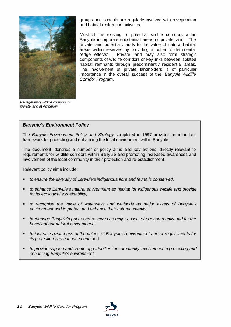
groups and schools are regularly involved with revegetation and habitat restoration activities. Most of the existing or potential wildlife corridors within Banyule incorporate substantial areas of private land. The private land potentially adds to the value of natural habitat areas within reserves by providing a buffer to detrimental “edge effects”. Private land may also form strategic components of wildlife corridors or key links between isolated habitat remnants through predominantly residential areas. The involvement of private landholders is of particular importance in the overall success of the Banyule Wildlife Corridor Program.
Banyule’s Environment Policy The Banyule Environment Policy and Strategy completed in 1997 provides an important framework for protecting and enhancing the local environment within Banyule. The document identifies a number of policy aims and key actions directly relevant to requirements for wildlife corridors within Banyule and promoting increased awareness and involvement of the local community in their protection and re-establishment. Relevant policy aims include: § to ensure the diversity of Banyule’s indigenous flora and fauna is conserved, § to enhance Banyule’s natural environment as habitat for indigenous wildlife and provide
for its ecological sustainability, § to recognise the value of waterways and wetlands as major assets of Banyule’s
environment and to protect and enhance their natural amenity, § to manage Banyule’s parks and reserves as major assets of our community and for the
benefit of our natural environment, § to increase awareness of the values of Banyule’s environment and of requirements for
its protection and enhancement, and § to provide support and create opportunities for community involvement in protecting and
enhancing Banyule’s environment.
Revegetating wildlife corridors on private land at Amberley
Banyule Wildlife Corridor Program 13
BANYULE’S WILDLIFE CORRIDORS Identifying Banyule’s Wildlife Corridors The determination of existing and potential wildlife corridors and habitat links within Banyule has aimed to provide linkages between natural habitat remnants throughout the municipality. Specific areas have been identified to establish a focus for habitat restoration by Council, other organisations and the local community within Banyule. They particularly aim to link sites of environmental significance and provide for strategic linkages between local residential areas and natural habitat which allow for the movement and dispersal of animals and plants. In a sense, the entire municipality can be regarded as forming part of a wildlife corridor, extending outwards from the Yarra River to link with more extensive areas of natural habitat north of Melbourne. The identification of wildlife corridors follows from a previous study undertaken for the former City of Heidelberg (Appleby et al. 1992) and expanded for the new Banyule municipality. “Strategic habitat links” have also been identified previously for the region north-east of Melbourne (Beardsell 1997). The Banyule wildlife corridors have been incorporated within this regional network.
Major Wildlife Corridors provide a key focus for the movement and dispersal of animals and plants throughout the municipality and beyond. The corridors are charac terised by virtually continuous reserves incorporating a major natural feature, such as a waterway, and retaining significant habitat values. They extend over a substantial length and incorporate adjoining residential areas to maximise their width and effectiveness. They form key components of regional “strategic habitat links”. Local Habitat Links provide linkages between otherwise isolated natural habitat areas locally. The links incorporate reserves and natural features wherever possible, but also rely on the inclusion of residential areas that retain habitat remnants, particularly indigenous vegetation. They are intended to link local areas with major wildlife corridors or more extensive habitat beyond Banyule, to maximise opportunities for the movement and dispersal of animals and plants in the regional context. Other potential habitat links within Banyule are also identified. Descriptions of Major Wildlife Corridors and Local Habitat Links identified within Banyule and their main features are provided in the following sections. Key requirements for enhancing their values are outlined.
Wildlife corridors within Banyule have been grouped into two main categories: § Major Wildlife Corridors and § Local Habitat Links.
14 Banyule Wildlife Corridor Program
Yarra River - Major Wildlife Corridor Location: Follows the Yarra River along the southern boundary of Banyule from Lower Plenty downstream to Ivanhoe. The corridor extends further upstream to the Upper Yarra Valley and downstream towards Yarra Bend Park. Habitat features: The Yarra River forms Melbourne’s most significant wildlife corridor. The river links natural habitats in the inner suburbs with the extensive mountain forests of the Yarra Ranges National Park across the Yarra River flood plain to the east. Within Banyule, the corridor incorporates extensive areas of natural habitat along the river and its flood plain. The corridor provides links between the Darebin Creek, Plenty River and Diamond Creek catchments locally. Immediately south of the Yarra River (beyond Banyule) there are links with the Ruffey and Koonung Creeks. Natural habitats include virtually continuous indigenous vegetation adjacent to the river and a number of wetlands.
Significant wetlands are Banyule Flats wetland, Banyule Billabong and Warringal Swamp in Heidelberg, and Annulus Billabong, Horseshoe Billabong, Reedy Billabong and Bailey Billabong in Ivanhoe. Many large and old specimens of River Red Gum occur throughout the Yarra River flood plain. Land ownership: An extensive network of parks and reserves occur along the Yarra River, managed by Banyule Council and Parks Victoria. Some residential properties abut the river around Lower Plenty and Ivanhoe. The privately owned Rosanna Golf Club is adjacent to the river in Lower Plenty. Ivanhoe Public Golf Course also abuts the river. The corridor incorporates adjoining residential areas in Lower Plenty, Heidelberg and Ivanhoe (also Templestowe and Bulleen south of Banyule). Vegetation types: Riverine Forest, Plains Riparian Woodland, Plains Woodland, Swamp Scrub, Grassy Wetland and Wetland. refer Brown (1996b) Key sites: Yarra Valley Parklands (Parks Victoria), Rosanna Golf Club (private), Banyule Flats Reserve, Warringal Parklands, Yarra Flats Park (Parks Victoria), Ivanhoe Public Golf Course, Chelsworth Park and Wilson Reserve. Requirements: § ongoing planting of indigenous vegetation and habitat restoration within reserves, § integration of habitat restoration with recreational uses of reserves, particularly around
sporting fields and within golf courses, § establishment of regeneration areas around remnant River Red Gums (currently mown), § protection of remnant indigenous vegetation within residential properties, § establishment of frontage reserves where private property abuts the river (when
opportunities arise), § re-establishment of indigenous vegetation within residential properties, particularly
understorey plants, § planting of indigenous vegetation along roadsides,
Yarra River
Banyule Wildlife Corridor Program 15
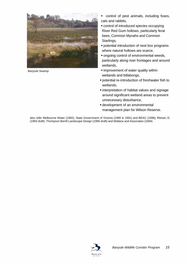
§ control of pest animals, including foxes, cats and rabbits, § control of introduced species occupying River Red Gum hollows, particularly feral bees, Common Mynahs and Common Starlings, § potential introduction of nest box programs where natural hollows are scarce, § ongoing control of environmental weeds, particularly along river frontages and around wetlands, § improvement of water quality within wetlands and billabongs, § potential re-introduction of freshwater fish to
wetlands, § interpretation of habitat values and signage
around significant wetland areas to prevent unnecessary disturbance, § development of an environmental
management plan for Wilson Reserve. also refer Melbourne Water (1992), State Government of Victoria (1990 & 1991) and BEAC (1996), Ritman, D. (1993 draft), Thompson Berrill Landscape Design (1995 draft) and Wallace and Associates (1994)
Banyule Swamp
16 Banyule Wildlife Corridor Program
Yarra Catchment - Local Habitat Links Salt Creek Link
Location: Follows Salt Creek from Gresswell Forest in Bundoora downstream to its confluence with the Yarra River at Warringal Park in Heidelberg. Habitat features: Salt Creek links important natural habitat within Gresswell Forest Reserve (adjacent to Banyule) with the Yarra River Corridor. Residential areas within Macleod retaining a good cover of remnant River Red Gums and the Rosanna Parklands are components of the link along Salt Creek. The Rosanna Parklands support indigenous forest remnants and planted native trees providing substantial habitat for birds and possums. Indigenous vegetation remnants in Harry Pottage Reserve are included in the link. Planted native trees are a feature of residential areas and street plantings throughout Macleod and Rosanna, providing feeding habitat for a variety of birds. Land ownership: The Rosanna Parklands and Macleod Park occur along Salt Creek for a substantial length north of
Lower Plenty Road. The creek flows through or is adjacent to residential properties elsewhere. Some sections of the creek in Macleod and Rosanna have been diverted through underground barrel drains. The link incorporates adjoining residential areas in Macleod, Rosanna and Heidelberg. Vegetation types: Swamp Gum Valley Forest and Plains Riparian Woodland. refer Brown (1996b) Key sites: Dunvegan Parkland, Harry Pottage Reserve, Macleod High School, Macleod Park, Rosanna Parklands, De Winton Park, Heidelberg Park and Warringal Park. Requirements: § planting of indigenous trees and understorey vegetation in reserves and along
roadsides, § establishment of regeneration areas around remnant River Red Gums in Macleod
(currently mown), § protection of remnant River Red Gums in residential areas in Macleod, § re-establishment of indigenous vegetation within residential properties, including trees
and understorey vegetation, § control of litter entering and along the creek, § ongoing protection and restoration of remnant indigenous vegetation within Harry
Pottage Reserve, § reinforcement of links through linear drainage reserves in Rosanna, § development of an environmental management plan for the Rosanna Parklands. also refer Kern and Muyt (1995), Appleby et al. (1992) and BEAC (1996)
Salt Creek, Rosanna Parklands
Banyule Wildlife Corridor Program 17
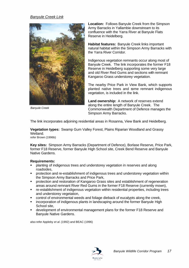
Banyule Creek Link
Location: Follows Banyule Creek from the Simpson Army Barracks in Yallambie downstream to its confluence with the Yarra River at Banyule Flats Reserve in Heidelberg. Habitat features: Banyule Creek links important natural habitat within the Simpson Army Barracks with the Yarra River Corridor. Indigenous vegetation remnants occur along most of Banyule Creek. The link incorporates the former F18 Reserve in Heidelberg supporting some very large and old River Red Gums and sections with remnant Kangaroo Grass understorey vegetation. The nearby Price Park in View Bank, which supports planted native trees and some remnant indigenous vegetation, is included in the link. Land ownership: A network of reserves extend along the entire length of Banyule Creek. The Commonwealth Department of Defence manages the Simpson Army Barracks.
The link incorporates adjoining residential areas in Rosanna, View Bank and Heidelberg. Vegetation types: Swamp Gum Valley Forest, Plains Riparian Woodland and Grassy Wetland. refer Brown (1996b) Key sites: Simpson Army Barracks (Department of Defence), Borlase Reserve, Price Park, former F18 Reserve, former Banyule High School site, Creek Bend Reserve and Banyule Native Gardens. Requirements: § planting of indigenous trees and understorey vegetation in reserves and along
roadsides, § protection and re-establishment of indigenous trees and understorey vegetation within
the Simpson Army Barracks and Price Park, § protection and restoration of Kangaroo Grass sites and establishment of regeneration
areas around remnant River Red Gums in the former F18 Reserve (currently mown), § re-establishment of indigenous vegetation within residential properties, including trees
and understorey vegetation, § control of environmental weeds and foliage dieback of eucalypts along the creek, § incorporation of indigenous plants in landscaping around the former Banyule High
School site, § development of environmental management plans for the former F18 Reserve and
Banyule Native Gardens. also refer Appleby et al. (1992) and BEAC (1996)
Banyule Creek
18 Banyule Wildlife Corridor Program
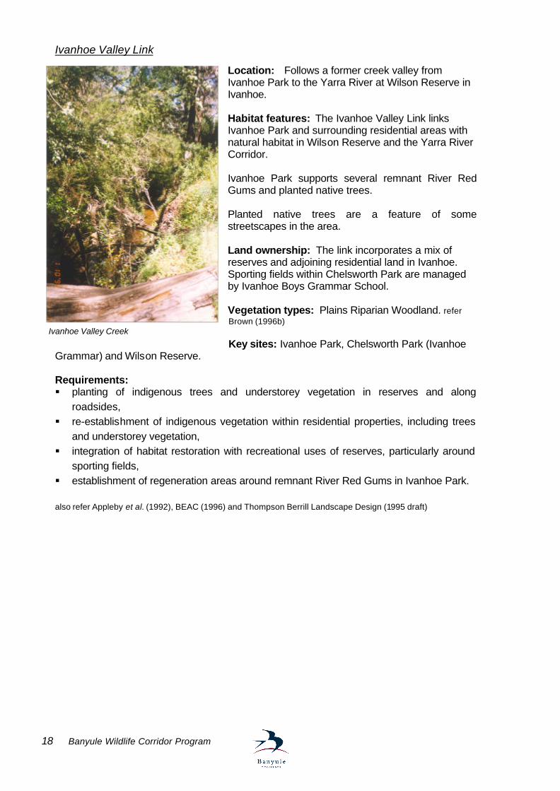
Ivanhoe Valley Link Location: Follows a former creek valley from Ivanhoe Park to the Yarra River at Wilson Reserve in Ivanhoe. Habitat features: The Ivanhoe Valley Link links Ivanhoe Park and surrounding residential areas with natural habitat in Wilson Reserve and the Yarra River Corridor. Ivanhoe Park supports several remnant River Red Gums and planted native trees. Planted native trees are a feature of some streetscapes in the area. Land ownership: The link incorporates a mix of reserves and adjoining residential land in Ivanhoe. Sporting fields within Chelsworth Park are managed by Ivanhoe Boys Grammar School. Vegetation types: Plains Riparian Woodland. refer Brown (1996b) Key sites: Ivanhoe Park, Chelsworth Park (Ivanhoe
Grammar) and Wilson Reserve. Requirements: § planting of indigenous trees and understorey vegetation in reserves and along
roadsides, § re-establishment of indigenous vegetation within residential properties, including trees
and understorey vegetation, § integration of habitat restoration with recreational uses of reserves, particularly around
sporting fields, § establishment of regeneration areas around remnant River Red Gums in Ivanhoe Park. also refer Appleby et al. (1992), BEAC (1996) and Thompson Berrill Landscape Design (1995 draft)
Ivanhoe Valley Creek
Banyule Wildlife Corridor Program 19
Plenty River - Major Wildlife Corridor
Location: Follows the Plenty River from the northern boundary of Banyule in Greensborough downstream to its confluence with the Yarra River in Lower Plenty. The corridor extends further upstream through the Plenty Gorge and beyond. Habitat features: The Plenty River is a major waterway flowing through the centre of Banyule. The river links important natural habitat remnants at Plenty Gorge (north of Banyule) with the Yarra River Corridor. It also extends further upstream to link with forested hills around Kinglake National Park to the north.
Within Banyule, the corridor supports virtually continuous indigenous vegetation adjacent to the Plenty River along most of its length. A number of rocky escarpments provide habitat for locally uncommon plants and animals adjacent to the river, particularly around Partington’s Flat in Greensborough, Yallambie Flats and in Lower Plenty. Many large and old trees are found along the Plenty River, including River Red Gums around View Bank and Lower Plenty, and Manna Gums further upstream. Linear reserves supporting remnant indigenous vegetation across hills north of Partington’s Flat are included in the corridor.
Land ownership: An extensive network of parks and reserves occur along the Plenty River. Parks Victoria manages the Yarra Valley Parklands in View Bank at the confluence with the Yarra River. Privately owned land abutting the river includes some residential properties around Greensborough, Montmorency and View Bank, commercial premises in Greensborough and Briar Hill, and two golf courses in Lower Plenty. The corridor incorporates adjoining residential areas in Greensborough, Briar Hill, Montmorency, Yallambie, View Bank and Lower Plenty. Vegetation types: Riparian Forest, Yellow Box Valley Forest, Box Woodland, Plains Woodland and Plains Grassland. refer Brown (1996b)
Key sites: Partington’s Flat, Greensborough Park, Whatmough Park, Poulter Avenue Reserve, Willinda Park, Montmorency Secondary College, Montmorency Park, Yallambie Flats, Glenauburn Park, Yallambie Park, Heidelberg Golf Club (private), Yarra Valley Parklands (Parks Victoria) and Rosanna Golf Club (private). Requirements: § ongoing planting of indigenous vegetation and habitat restoration within reserves, § integration of habitat restoration with recreational uses of reserves, particularly around
sporting fields and within golf courses, § protection of remnant indigenous vegetation within residential properties,
Plenty River
Koala Neil Murray
20 Banyule Wildlife Corridor Program
§ establishment of frontage reserves where private property abuts the river (when opportunities arise),
§ re-establishment of indigenous vegetation within residential properties, particularly understorey plants,
§ establishment of regeneration areas around remnant indigenous vegetation in reserves north of Partington’s Flat (currently mown),
§ incorporation of indigenous plants in the landscaping of commercial properties around Greensborough and Briar Hill,
§ planting of indigenous vegetation along roadsides, § control of pest animals, including foxes, cats and rabbits, § control of introduced species occupying River Red Gum and Manna Gum hollows,
particularly feral bees, Common Mynahs and Common Starlings, § potential introduction of nest box programs where natural hollows are scarce, § ongoing control of environmental weeds, particularly along river frontages and on
escarpments, § control of litter entering and along the river, § monitoring and prevention of water pollution from commercial areas, § development of an environmental management plan for Partington’s Flat and adjoining
linear reserves. also refer MPW (1994) and BEAC (1996)
Banyule Wildlife Corridor Program 21
Plenty Catchment – Local Habitat Links Yallambie Creek Link Location: Follows Yallambie Creek from north of the Simpson Army Barracks in Yallambie downstream to its confluence with the Plenty River in View Bank. Habitat features: Yallambie Creek links important natural habitat areas within the Simpson Army Barracks and residential areas in Yallambie with the Plenty River Corridor. Remnant indigenous vegetation occurs along sections of the creek through Streeton Views Estate and within small reserves near the Plenty River. Some sections of Yallambie Creek have been diverted through underground barrel drains downstream of the Simpson Army Barracks. The link incorporates remnant indigenous trees within Timber Ridge Reserve and scattered throughout Streeton Views Estate. They include large and old River Red Gums and also the largest known stand of Studley Park Gums. The adjacent Yallambie Primary School (north of Yallambie Road) includes planted native trees providing habitat for birds. The reserve in Streeton Views Estate along Lower Plenty Road is included in the link. A wetland area has been established within the reserve attracting a number of waterbirds. It also supports several old River Red Gums. Land ownership: Most of the link is through residential land, however a number of small reserves are located along the route of Yallambie Creek within Streeton Views Estate and View Bank. The Commonwealth Department of Defence manages the Simpson Army Barracks. The link incorporates adjoining residential areas in Yallambie and View Bank. Vegetation types: Swamp Gum Valley Forest, Sedimentary Plains Woodland and Box Woodland. refer Brown (1996b) Key sites: Timber Ridge Reserve, Yallambie Primary School, Simpson Army Barracks (Department of Defence), Streeton Views Estate Reserve and other small reserves within Streeton Views Estate and View Bank. Requirements: § planting of indigenous trees and understorey vegetation in reserves and along roadsides, § re-establishment of indigenous vegetation within residential properties, including trees and
understorey vegetation, § protection of remnant indigenous trees (including River Red Gums) within Streeton Views
Estate, § establishment of regeneration areas around remnant River Red Gums within reserves
(currently mown), § habitat restoration and control of environmental weeds in reserves near the Plenty River
and Timber Ridge Reserve. also refer Appleby et al. (1992), Barlow (1991) and BEAC (1996)
22 Banyule Wildlife Corridor Program
Northern Foothills Link Location: Extends over hills in residential areas throughout Lower Plenty, Montmorency, Briar Hill, Greenhills (east part of Greensborough) and St. Helena to the northern boundary of Banyule. The link extends further north towards Diamond Creek, Yarrambat and beyond. Habitat features: The Northern Foothills Link links residential areas supporting substantial bushland remnants east of the Plenty River with rural foothills to the north of Banyule.
Within Banyule, it provides linkages between a number of reserves supporting important natural habitat scattered throughout Montmorency, Briar Hill, Greenhills and St. Helena. It also links the Plenty River and Diamond Creek catchments locally. The good cover of indigenous trees throughout residential areas east of the Plenty River is a particular feature. The indigenous vegetation provides habitat for a diverse range of forest birds which are uncommon or no longer occur in other urban areas within Banyule. Some larger residential properties around Lower Plenty support many remnant indigenous trees. Substantial remnants of Yellow Gum Woodland occur throughout residential areas in Greenhills, providing important habitat for a variety of birds, including Swift Parrots, and possums. Colonies of the Eltham Copper Butterfly occur around Greenhills and Montmorency. Remnant bushland around St. Helena supports important indigenous understorey vegetation, including a diverse range of terrestrial orchids. Bushland reserves retaining significant natural habitat include Andrew Yandell Habitat Reserve and Brown’s Nature Reserve in Greenhills, Peck’s Dam Reserve and Rattray Reserve in Montmorency, and St. Helena Bush Reserve. Many small reserves supporting bushland remnants are scattered throughout the area. St. Helena Road supports a good cover of remnant indigenous vegetation and planted natives along much of its length which is of strategic importance in maintaining the continuity of the Northern Foothills Link in a north-south direction. The ring road reservation, extending along the northern boundary of Banyule, is of strategic importance in providing an east-west linkage between the Plenty River and Diamond Creek catchments. Land ownership: The link incorporates mostly residential land throughout Lower Plenty, Montmorency, Briar Hill, Greenhills and St. Helena (also Diamond Creek north of Banyule). Many reserves are scattered throughout the area. Vegetation types: Dry Sclerophyll Forest, Yellow Box Valley Forest, Box Woodland and Yellow Gum Sclerophyll Woodland. refer Brown (1996b) Key sites: Peck’s Dam Reserve, Rattray Reserve, Kirwana Reserve, and Sackville
Eucalypt canopy, Greenhills
Banyule Wildlife Corridor Program 23
Reserve in Montmorency. Briar Valley Reserve and E.J. Andrew Reserve in Briar Hill. Andrew Yandell Habitat Reserve, Brown’s Nature Reserve and Keswick Glen Reserve in Greenhills. St. Helena Bush Reserve, Dalvida Reserve, Settler’s Park, Anthony Beale Reserve and St. Helena Road in St. Helena. Ring road reservation between Civic Drive in Greensborough and Ryans Road in St. Helena. Many other reserves and school grounds supporting remnant indigenous vegetation and planted native trees throughout the area east of the Plenty River. Requirements: § planting of indigenous trees and understorey vegetation in reserves and along
roadsides, § establishment of regeneration areas around remnant indigenous vegetation within
reserves (currently mown), § protection and re-establishment of indigenous vegetation within residential properties,
including trees and understorey vegetation, § control of environmental weeds and pest animals within bushland reserves, § potential use of ecological burning for improving quality of understorey vegetation within
reserves, § specific programs for re-establishment of Eltham Copper Butterfly habitat around
Greenhills and Montmorency, particularly through planting of Sweet Bursaria, § reinforcement of indigenous vegetation linkages along St. Helena Road, the ring road
reservation and through linear reserves in St. Helena (particularly Settler’s Park) and Montmorency,
§ ongoing habitat restoration programs within key reserves, particularly Andrew Yandell Habitat Reserve, Brown’s Nature Reserve, Peck’s Dam Reserve and St. Helena Bush Reserve.
§ development of environmental management plans for Settler’s Park, Anthony Beale Reserve and Dalvida Reserve.
also refer Robinson and Carmichael (1992 & 1993), Brown (1996c), Paget (1989), Vaughan (1988) and BEAC (1996)
24 Banyule Wildlife Corridor Program
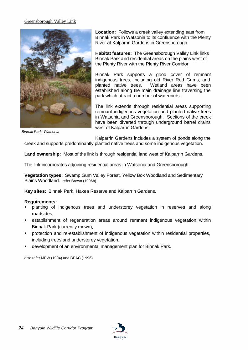
Greensborough Valley Link Location: Follows a creek valley extending east from Binnak Park in Watsonia to its confluence with the Plenty River at Kalparrin Gardens in Greensborough. Habitat features: The Greensborough Valley Link links Binnak Park and residential areas on the plains west of the Plenty River with the Plenty River Corridor. Binnak Park supports a good cover of remnant indigenous trees, including old River Red Gums, and planted native trees. Wetland areas have been established along the main drainage line traversing the park which attract a number of waterbirds. The link extends through residential areas supporting remnant indigenous vegetation and planted native trees in Watsonia and Greensborough. Sections of the creek have been diverted through underground barrel drains west of Kalparrin Gardens. Kalparrin Gardens includes a system of ponds along the
creek and supports predominantly planted native trees and some indigenous vegetation. Land ownership: Most of the link is through residential land west of Kalparrin Gardens. The link incorporates adjoining residential areas in Watsonia and Greensborough. Vegetation types: Swamp Gum Valley Forest, Yellow Box Woodland and Sedimentary Plains Woodland. refer Brown (1996b) Key sites: Binnak Park, Hakea Reserve and Kalparrin Gardens. Requirements: § planting of indigenous trees and understorey vegetation in reserves and along
roadsides, § establishment of regeneration areas around remnant indigenous vegetation within
Binnak Park (currently mown), § protection and re-establishment of indigenous vegetation within residential properties,
including trees and understorey vegetation, § development of an environmental management plan for Binnak Park. also refer MPW (1994) and BEAC (1996)
Binnak Park, Watsonia
Banyule Wildlife Corridor Program 25
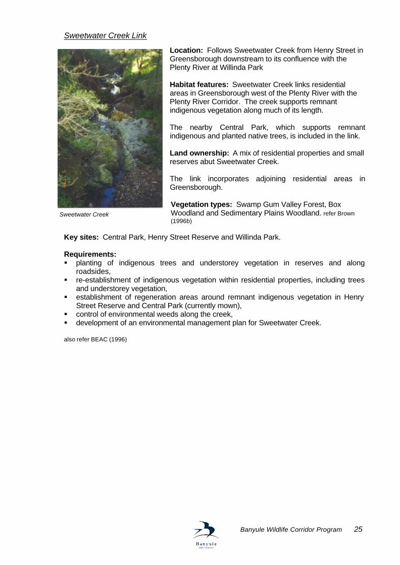
Sweetwater Creek Link
Location: Follows Sweetwater Creek from Henry Street in Greensborough downstream to its confluence with the Plenty River at Willinda Park Habitat features: Sweetwater Creek links residential areas in Greensborough west of the Plenty River with the Plenty River Corridor. The creek supports remnant indigenous vegetation along much of its length. The nearby Central Park, which supports remnant indigenous and planted native trees, is included in the link. Land ownership: A mix of residential properties and small reserves abut Sweetwater Creek. The link incorporates adjoining residential areas in Greensborough. Vegetation types: Swamp Gum Valley Forest, Box Woodland and Sedimentary Plains Woodland. refer Brown (1996b)
Key sites: Central Park, Henry Street Reserve and Willinda Park. Requirements: § planting of indigenous trees and understorey vegetation in reserves and along
roadsides, § re-establishment of indigenous vegetation within residential properties, including trees
and understorey vegetation, § establishment of regeneration areas around remnant indigenous vegetation in Henry
Street Reserve and Central Park (currently mown), § control of environmental weeds along the creek, § development of an environmental management plan for Sweetwater Creek. also refer BEAC (1996)
Sweetwater Creek
26 Banyule Wildlife Corridor Program
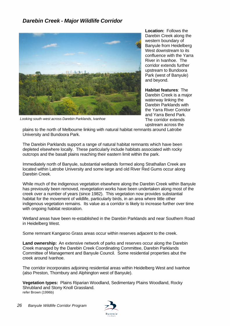
Darebin Creek - Major Wildlife Corridor
Location: Follows the Darebin Creek along the western boundary of Banyule from Heidelberg West downstream to its confluence with the Yarra River in Ivanhoe. The corridor extends further upstream to Bundoora Park (west of Banyule) and beyond. Habitat features: The Darebin Creek is a major waterway linking the Darebin Parklands with the Yarra River Corridor and Yarra Bend Park. The corridor extends upstream across the
plains to the north of Melbourne linking with natural habitat remnants around Latrobe University and Bundoora Park. The Darebin Parklands support a range of natural habitat remnants which have been depleted elsewhere locally. These particularly include habitats associated with rocky outcrops and the basalt plains reaching their eastern limit within the park. Immediately north of Banyule, substantial wetlands formed along Strathallan Creek are located within Latrobe University and some large and old River Red Gums occur along Darebin Creek. While much of the indigenous vegetation elsewhere along the Darebin Creek within Banyule has previously been removed, revegetation works have been undertaken along most of the creek over a number of years (since 1982). This vegetation now provides substantial habitat for the movement of wildlife, particularly birds, in an area where little other indigenous vegetation remains. Its value as a corridor is likely to increase further over time with ongoing habitat restoration. Wetland areas have been re-established in the Darebin Parklands and near Southern Road in Heidelberg West. Some remnant Kangaroo Grass areas occur within reserves adjacent to the creek. Land ownership: An extensive network of parks and reserves occur along the Darebin Creek managed by the Darebin Creek Coordinating Committee, Darebin Parklands Committee of Management and Banyule Council. Some residential properties abut the creek around Ivanhoe. The corridor incorporates adjoining residential areas within Heidelberg West and Ivanhoe (also Preston, Thornbury and Alphington west of Banyule). Vegetation types: Plains Riparian Woodland, Sedimentary Plains Woodland, Rocky Shrubland and Stony Knoll Grassland. refer Brown (1996b)
Looking south-west across Darebin Parklands, Ivanhoe
Banyule Wildlife Corridor Program 27
Key sites: Olympic Park, Southern Road Wetland, Darebin Creek Forest Park, Seddon Reserve, Darebin Parklands (Committee of Management) and Sparkes Reserve. Requirements: § ongoing planting of indigenous vegetation and habitat restoration within reserves, § integration of habitat restoration with recreational uses of reserves, particularly around
sporting fields, § establishment of frontage reserves where private property abuts the river (when
opportunities arise), § re-establishment of indigenous vegetation within residential properties, including trees
and understorey plants, § planting of indigenous trees and understorey along roadsides, § protection and restoration of remnant rocky outcrop vegetation and Kangaroo Grass
sites, § control of pest animals, including foxes, cats and rabbits, § ongoing control of environmental weeds, particularly along river frontages and within the
Darebin Parklands, § monitoring and prevention of water pollution from industrial areas, § incorporation of indigenous plants in the landscaping of commercial properties around
Heidelberg West, § development of environmental management plans for sections of the Darebin Creek
Forest Park between Southern Road and Bell Street in Heidelberg West (Reach 6) and between Banksia Street and Darebin Road in Ivanhoe (Reach 8).
also refer MPW (1995), Kern (1997) and Pfitzner (1987)
Darebin Creek
28 Banyule Wildlife Corridor Program
Darebin Catchment - Local Habitat Links Donaldson’s Creek Link
Location: Follows Donaldson’s Creek from Banksia Street in Ivanhoe downstream to its confluence with the Darebin Creek in Darebin Parklands. Habitat features: Donaldson’s Creek links residential areas within Ivanhoe with the Darebin Creek Corridor. While most of Donaldson’s Creek has been diverted through underground barrel drains, the reserves following its course and the Austin Repatriation Hospital support many planted native and some remnant indigenous trees providing habitat for birds and possums locally. Remnant River Red Gums are
also found at the nearby Banyule Aquatic Centre. Land ownership:A network of reserves extend along the entire length of Donaldson’s Creek. The link incorporates adjoining residential areas in Ivanhoe. Vegetation types: Sedimentary Plains Woodland. refer Brown (1996b) Key sites: Austin Repatriation Hospital, Donaldson’s Reserve, Banyule Aquatic Centre, Cartledge Reserve, Hannah Reserve and Nellie Ibbott Reserve. Requirements: § planting of indigenous trees and understorey vegetation in reserves and along
roadsides, § re-establishment of indigenous vegetation within residential properties, including trees
and understorey vegetation, § protection of remnant River Red Gums within the Austin Repatriation Hospital and
Banyule Aquatic Centre grounds. also refer Appleby et al. (1992)
Donaldson Creek
Banyule Wildlife Corridor Program 29
Darebin Catchment - Potential Habitat Links West Heidelberg Industrial Estate Location: The area bounded by Sheehan Avenue, Crissane Road, Waterdale Road and Dougharty Road. Habitat features: Remnant River Red Gums, exotic eucalypts and other natives in factory and office yards link to the Darebin Creek below Sheehan Avenue and Latrobe University nature reserve above Crissane Road Land ownership: Private Vegetation types: Plains Grassy Woodland Requirements: § planting of indigenous trees and understorey vegetation in reserves and along
roadsides, § re-establishment of indigenous vegetation within industrial properties, including trees
and understorey vegetation.
Southern Road Link Location: Road Reserve avenue linking open space in Shelley Reserve, Malahang Reserve and Olympic Village Primary School with the Darebin Creek Habitat features: Mature Eucalypts and native and exotic plantings in parks and school grounds. Land ownership: Council, State Government Vegetation types: Plains Grassy Woodland Requirements: § planting of indigenous trees and understorey vegetation in reserves and along
roadsides; § re-establishment of indigenous vegetation within industrial properties including trees and
understorey vegetation
Banksia Street Link Location: Follows Banksia Street road reserve and links Ford Park with open space associated with Banksia Secondary College, Bellfield Primary School, BBC Central Depot and Heidelberg Repatriation Hospital Habitat features: Mature Eucalypts both introduced and remnant. The avenue of Red Ironbark Eucalyptus tricarpa along the Banksia St road reserve link areas of open space between the Darebin Creek and the Austin/Repatriation Hospital. Ironbark avenue, Banksia St, Heidelbeg West
30 Banyule Wildlife Corridor Program
Land ownership: Road reserve, Council, State Government. Vegetation types: Plains Grassy Woodland Requirements: § encourage planting of indigenous vegetation on school and hospital grounds
Banyule Wildlife Corridor Program 31
Connecting the Major Wildlife Corridors Yallambie-Bundoora Plains Link
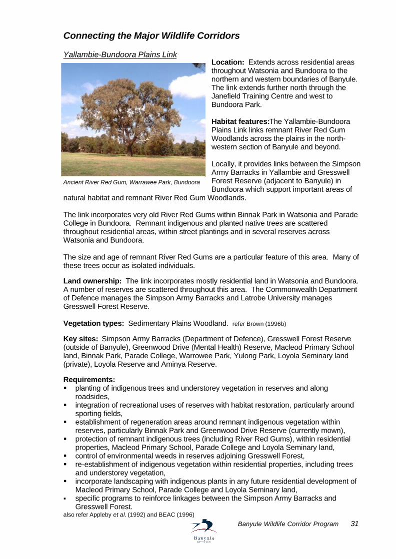
Location: Extends across residential areas throughout Watsonia and Bundoora to the northern and western boundaries of Banyule. The link extends further north through the Janefield Training Centre and west to Bundoora Park. Habitat features:The Yallambie-Bundoora Plains Link links remnant River Red Gum Woodlands across the plains in the north-western section of Banyule and beyond. Locally, it provides links between the Simpson Army Barracks in Yallambie and Gresswell Forest Reserve (adjacent to Banyule) in Bundoora which support important areas of
natural habitat and remnant River Red Gum Woodlands. The link incorporates very old River Red Gums within Binnak Park in Watsonia and Parade College in Bundoora. Remnant indigenous and planted native trees are scattered throughout residential areas, within street plantings and in several reserves across Watsonia and Bundoora. The size and age of remnant River Red Gums are a particular feature of this area. Many of these trees occur as isolated individuals. Land ownership: The link incorporates mostly residential land in Watsonia and Bundoora. A number of reserves are scattered throughout this area. The Commonwealth Department of Defence manages the Simpson Army Barracks and Latrobe University manages Gresswell Forest Reserve. Vegetation types: Sedimentary Plains Woodland. refer Brown (1996b) Key sites: Simpson Army Barracks (Department of Defence), Gresswell Forest Reserve (outside of Banyule), Greenwood Drive (Mental Health) Reserve, Macleod Primary School land, Binnak Park, Parade College, Warrowee Park, Yulong Park, Loyola Seminary land (private), Loyola Reserve and Aminya Reserve. Requirements: § planting of indigenous trees and understorey vegetation in reserves and along
roadsides, § integration of recreational uses of reserves with habitat restoration, particularly around
sporting fields, § establishment of regeneration areas around remnant indigenous vegetation within
reserves, particularly Binnak Park and Greenwood Drive Reserve (currently mown), § protection of remnant indigenous trees (including River Red Gums), within residential
properties, Macleod Primary School, Parade College and Loyola Seminary land, § control of environmental weeds in reserves adjoining Gresswell Forest, § re-establishment of indigenous vegetation within residential properties, including trees
and understorey vegetation, § incorporate landscaping with indigenous plants in any future residential development of
Macleod Primary School, Parade College and Loyola Seminary land, § specific programs to reinforce linkages between the Simpson Army Barracks and
Gresswell Forest. also refer Appleby et al. (1992) and BEAC (1996)
Ancient River Red Gum, Warrawee Park, Bundoora
32 Banyule Wildlife Corridor Program
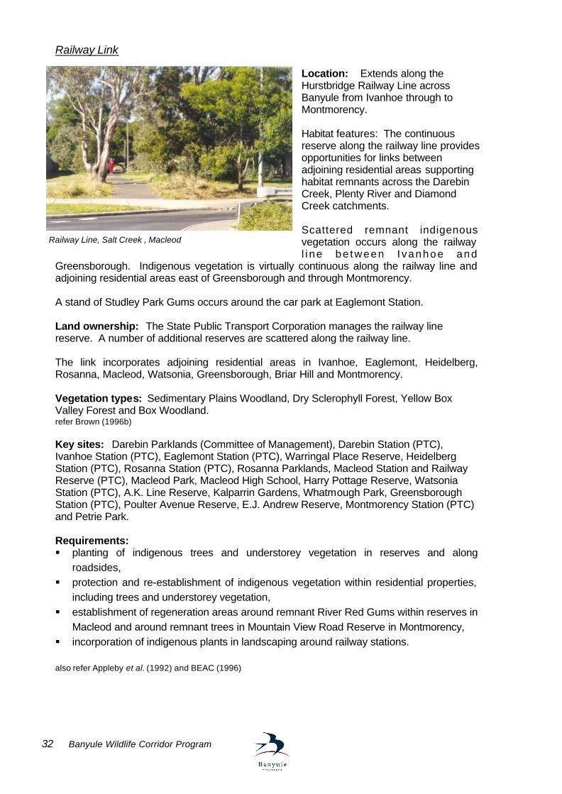
Railway Link Location: Extends along the Hurstbridge Railway Line across Banyule from Ivanhoe through to Montmorency. Habitat features: The continuous reserve along the railway line provides opportunities for links between adjoining residential areas supporting habitat remnants across the Darebin Creek, Plenty River and Diamond Creek catchments. Scattered remnant indigenous vegetation occurs along the railway l i ne be tween I vanhoe and
Greensborough. Indigenous vegetation is virtually continuous along the railway line and adjoining residential areas east of Greensborough and through Montmorency. A stand of Studley Park Gums occurs around the car park at Eaglemont Station. Land ownership: The State Public Transport Corporation manages the railway line reserve. A number of additional reserves are scattered along the railway line. The link incorporates adjoining residential areas in Ivanhoe, Eaglemont, Heidelberg, Rosanna, Macleod, Watsonia, Greensborough, Briar Hill and Montmorency. Vegetation types: Sedimentary Plains Woodland, Dry Sclerophyll Forest, Yellow Box Valley Forest and Box Woodland. refer Brown (1996b) Key sites: Darebin Parklands (Committee of Management), Darebin Station (PTC), Ivanhoe Station (PTC), Eaglemont Station (PTC), Warringal Place Reserve, Heidelberg Station (PTC), Rosanna Station (PTC), Rosanna Parklands, Macleod Station and Railway Reserve (PTC), Macleod Park, Macleod High School, Harry Pottage Reserve, Watsonia Station (PTC), A.K. Line Reserve, Kalparrin Gardens, Whatmough Park, Greensborough Station (PTC), Poulter Avenue Reserve, E.J. Andrew Reserve, Montmorency Station (PTC) and Petrie Park. Requirements: § planting of indigenous trees and understorey vegetation in reserves and along
roadsides, § protection and re-establishment of indigenous vegetation within residential properties,
including trees and understorey vegetation, § establishment of regeneration areas around remnant River Red Gums within reserves in
Macleod and around remnant trees in Mountain View Road Reserve in Montmorency, § incorporation of indigenous plants in landscaping around railway stations. also refer Appleby et al. (1992) and BEAC (1996)
Railway Line, Salt Creek , Macleod
Banyule Wildlife Corridor Program 33
Powerline Link Location: Follows the overhead high voltage transmission lines extending across Banyule from Lower Plenty through to Bundoora. Habitat features: The virtually continuous reserves along the powerlines provide opportunities for linking the Yarra River Corridor with the plains to the north of Melbourne and adjoining residential areas supporting habitat remnants across the Plenty River and Darebin Creek catchments. Remnant indigenous vegetation is scattered along the powerlines between the Yarra River in Lower Plenty and the Simpson Army Barracks in Yallambie. This includes areas with old River Red Gums. The powerlines link with the Plenty River Corridor where they cross the river in Yallambie. The Simpson Army Barracks support substantial areas of natural habitat. Planted native trees and shrubs follow sections of the powerline in reserves through Watsonia and Bundoora. Land ownership: The powerlines traverse private land and a golf course through Lower Plenty. North of Lower Plenty the powerlines are contained within continuous reserves managed by Powernet. A number of additional reserves are scattered along the powerlines. The Commonwealth Department of Defence manages the adjacent Simpson Army Barracks. The link incorporates adjoining residential areas in Lower Plenty, Yallambie, Greensborough, Watsonia and Bundoora. Vegetation types: Yellow Box Valley Forest, Box Woodland, Grassy Woodland and Sedimentary Plains Woodland. refer Brown (1996b) Key sites: Heidelberg Golf Club (private), Glenauburn Park, Yallambie Park, Simpson Army Barracks (Department of Defence), Elder Street Reserve, Gabonia Avenue Reserve and N.J. Telfer Reserve. Requirements: § planting of indigenous vegetation in reserves and along roadsides (including understorey
vegetation near powerlines), § protection and re-establishment of indigenous trees and understorey vegetation within
residential properties and the Heidelberg Golf Club, § specific programs to reinforce links between the Simpson Army Barracks and Plenty River
along the powerlines. Other potential habitat links A number of additional sites within Banyule have some potential to form habitat links locally where natural habitat is otherwise depleted. They generally include continuous sections of road reserve suitable for the re-establishment of indigenous trees and/or understorey vegetation. These include potential habitat links along: § the Greensborough Bypass Road, § Lower Plenty Road in Yallambie through to Main Road in Eltham, § Waterdale Road from Ivanhoe to Heidelberg West.
34 Banyule Wildlife Corridor Program
DEVELOPING BANYULE’S WILDLIFE CORRIDOR PROGRAM Aims and objectives The Banyule Wildlife Corridor Program aims to protect and re-establish wildlife corridors and habitat links within Banyule which allow for the movement and dispersal of native animals and plants.
Key strategies towards achieving these objectives will involve protecting indigenous vegetation and natural habitat remnants throughout Banyule, undertaking revegetation and habitat restoration activities within the major wildlife corridors and local habitat links identified in this study, and encouraging the re-establishment of habitat on private land within and adjacent to wildlife corridors. The effectiveness of these approaches will largely depend on sufficiently raising community awareness and involvement in the program and the availability of resources for implementing actions. Appropriate coordination and monitoring of outcomes is fundamental to the overall success and value of the program. Specific actions required in the implementation of the Banyule Wildlife Corridor Program are presented in the following sections.
Major objectives of the program are to: § Prevent further fragmentation of existing wildlife corridors and natural habitat within
Banyule. § Provide a focus for revegetation and habitat restoration activities on public and private
land throughout Banyule. § Raise awareness of the importance of wildlife corridors in maintaining biodiversity and
the ongoing sustainability of Banyule’s natural environment. § Provide opportunities for involvement of the local community in protecting and
enhancing Banyule’s natural environment.
Banyule Wildlife Corridor Program 35
Action plan Protecting vegetation and habitat remnants
The Banyule Planning Scheme provides an important mechanism for controlling the removal of vegetation and the level of habitat fragmentation within the municipality. It is recommended that the following measures be pursued which are dealt with in more detail in the subsequent discussion. • Vegetation Protection and Environmental Significance overlays; • conditions on planning permits; • the development of environmental management plans; • enforcement of planning permit conditions; • active monitoring of vegetation removal; • increased publicity of penalties for illegal vegetation removal; • controls on the proportion of a site covered by development; • set backs and site coverage control to provide buffers around reserves • seeking the involvement of real estate agents in education process Vegetation Protection Overlay controls currently apply to many areas supporting indigenous vegetation, particularly along wildlife corridors following the major waterways (Yarra River, Plenty River and Darebin Creek) and most of the area east of the Plenty River. They also apply in residential areas in Macleod and around the Streeton Views Estate in Yallambie. Environmental Significance Overlay controls, protecting vegetation and significant environmental values, apply to the areas currently identified as being sites of regional or higher environmental significance (refer Appendix 1). Individual trees and small stands of trees listed on the Banyule Significant Tree Register can be protected through a Heritage Overlay control in the planning scheme. Ongoing updating and extension of overlay controls should be undertaken as information on the significance of particular areas as wildlife corridors and requirements for their protection become apparent. Planning applications on land where these overlay controls apply should specifically be addressed in the context of impacts on wildlife corridors and natural habitat. Where potential conflicts arise, it is important to ensure that the environmental impacts of proposed developments are appropriately assessed. In many cases, developments can be integrated with natural values through careful planning and there are opportunities for re-establishing habitat links through the incorporation of conditions on planning permits. Such conditions should include requirements for protecting habitat remnants including indigenous understorey and regenerating vegetation, landscaping with indigenous plants and revegetation measures to compensate for any vegetation removed. They may also include requirements for the control of pest plants and animals, and specific measures for controlling drainage and waterway pollutants such as nutrient and sediment run-off. The development of environmental management plans should be required for sites supporting significant natural habitat or of strategic importance as wildlife corridors. The enforcement of planning permit conditions, active monitoring of vegetation removal, and increasing awareness of penalties and likely prosecution for the illegal removal of vegetation, have been identified as issues requiring particular attention to provide clear indication of the approach by Council towards protecting the local environment.
Action 1 Develop and implement planning controls where appropriate which provide
protection for indigenous vegetation and habitat remnants.
36 Banyule Wildlife Corridor Program
Urban development has been a major cause of habitat fragmentation within Banyule previously. The recent trend towards higher densities of residential dwellings places ongoing pressures on remaining natural habitat. Loss of habitat also arises where large single developments occur. In areas supporting substantial habitat remnants or of strategic importance as wildlife corridors, controls on housing density and/or the proportion of a site covered by development should be considered to prevent further habitat fragmentation and to allow for the re-establishment of wildlife corridors. Requirements for the provision of land as public open space, should also be pursued. Such measures may be incorporated into the Banyule Planning Scheme as local variations to residential zones. Specific areas identified where reduced site coverage is required to protect wildlife corridor values include around Lower Plenty, Greenhills, Macleod (particularly between Mont Park/Gresswell Forest and the Simpson Army Barracks) and areas adjacent to the Yarra River, Plenty River and Darebin Creek. Set backs and reduced site coverage would also be appropriate for properties adjoining reserves supporting natural habitat to provide buffers minimising the “edge effect” impacts of urban development. The involvement of real estate agents in increasing awareness of local planning requirements and promoting the conservation values of residential areas supporting natural habitat should be sought.
There are many remnant indigenous trees and planted native trees within Banyule which occur as isolated individuals or in small stands. They often provide shelter, feeding and breeding sites for native wildlife in locations where natural habitat has otherwise been depleted. They may also be of significance for their role in forming components of wildlife corridors. The existing Banyule Significant Tree Register provides an opportunity to list trees which are considered to be of conservation value locally and warrant specific protection through planning controls. A Significant Tree and Vegetation Study has just commenced which will assess trees across the municipality including those nominated by the public. This was required to establish a useful level of information for the register to operate effectively and to provide equitable levels of protection for significant trees across the municipality. This study should identify the vast majority of significant trees, but a community nomination process will be utilised for updating the list as additional information becomes available.
Parks and reserves within Banyule support substantial remnants of indigenous vegetation and natural habitat which are key components of wildlife corridors. Much work has already been undertaken in the protection of indigenous vegetation and habitat restoration along major waterways and in specific bushland reserves. It is important to ensure that work practices used in the management of parks and reserves throughout the municipality are consistent with protecting natural values and allow opportunities for the enhancement of environmental values wherever possible.
Action 3 Develop and implement work practices, procedures and “user-friendly’
guidelines for the management of parks, roadsides and other reserves which provide for the protection and enhancement of natural habitat.
Action 2 Undertake an inventory of locally significant trees for listing on the Banyule
Significant Tree Register.
Banyule Wildlife Corridor Program 37
Some of the relevant management issues identified for parks and reserves include: § allowing for natural regeneration by avoiding (where appropriate) the mowing of indigenous
understorey vegetation and around indigenous trees, § impacts of construction works, vehicles, road maintenance and clearing beneath
powerlines on indigenous vegetation, § control of pest plants and animals, § ongoing maintenance of revegetation areas, § replacement planting of street trees, § utilisation of indigenous plants in landscaping, and § integration of fire protection measures with habitat protection. “User-friendly” guidelines should be developed for Council workers, contractors and service providers involved with the management of parks and reserves within Banyule and undertaking construction or maintenance works within areas supporting indigenous vegetation or natural habitat. They should include information on who to contact for further advice and clearly identify requirements for the rehabilitation of disturbed areas.
Knowledge of the extent and types of indigenous vegetation occurring within Banyule are key requirements in planning for the protection and re-establishment of natural habitat and wildlife corridors. Mapping the quality and distribution of existing vegetation would particularly enable specific requirements for habitat protection to be determined and assist with establishing priorities for the restoration of depleted or fragmented wildlife corridors. A diverse range of indigenous vegetation communities have been identified locally. Maps of their current and former distribution would provide a valuable guide for revegetation and habitat restoration activities undertaken by Council, other organisations and the local community.
Many of the parks and reserves supporting natural habitat remnants within Banyule are utilised for sporting and other recreational purposes. Some also include landscapes, exotic vegetation or structures of heritage significance. Environmental management plans provide opportunities to clearly identify priorities for the protection and enhancement of natural habitat and for integration with recreational uses and heritage values. Key components should include: § assessment of environmental values, § identification of management issues, § the designation of vegetation and habitat protection areas, § requirements for the re-establishment and ongoing maintenance of indigenous vegetation,
and § measures for fire protection (where relevant). A range of management plans, master plans and concept plans already exist for reserves within Banyule which identify specific requirements for habitat protection and enhancement (refer References and Further Reading).
Action 4 Prepare maps indicating the current extent of indigenous vegetation within
Banyule and identifying the former distribution of indigenous vegetation communities throughout the municipality
Action 5 Develop and implement environmental management plans for natural habitat
areas and key reserves.
38 Banyule Wildlife Corridor Program
Priority reserves identified for the development of additional environmental management plans include: § Partington’s Flat and Sweetwater Creek in Greensborough, § Yallambie Flats Reserve, § Rosanna Parklands, § Binnak Park and Greenwood Drive (Mental Health) Reserve in Watsonia, § Settler’s Park, Dalvida Reserve and Anthony Beale Reserve in St. Helena, § sections of the Darebin Creek Forest Park in Heidelberg West and Ivanhoe, § Donaldsons Creek in West Ivanhoe, § Wilson Reserve, Seddon Reserve and Napier Waller Reserve in Ivanhoe, and § the former F18 Reserve in Heidelberg.
Local laws administered by Council offer opportunities for preventing some of the detrimental impacts of inappropriate activities on wildlife and natural habitat within Banyule. Restrictions on the access of dogs and cats to environmentally sensitive areas within reserves have previously been addressed and require ongoing review and enforcement (refer Jackson 1996). Other issues identified which may best be approached through the development and enforcement of local laws include the dumping of rubbish (including building materials and garden refuse) within reserves, the control of weeds on private property, and damage to vegetation caused by digging for worms along waterways. Requirements for the development of additional local laws to assist with protecting the local environment should be investigated. Enforcement and education should work together to achieve the desired change of behaviour in sensitive reserves.
Action 6 Develop and enforce local laws for the protection of wildlife and natural habitat.
Banyule Wildlife Corridor Program 39
Revegetation and habitat restoration
The Banyule Wildlife Corridor Program is intended to provide a key focus for revegetation and habitat restoration activities undertaken within the municipality. Revegetation priorities will largely depend on the strategic importance of indigenous vegetation in the wildlife corridor network, the requirements of particular species, the long-term suitability of revegetation sites, and the level of community support for revegetation activities. Extensive revegetation activities have already been undertaken along the Yarra River, Plenty River and Darebin Creek. These have been identified as priority sites for the ongoing re-establishment of indigenous vegetation because of their continuity, existing habitat values and role as major wildlife corridors. Other sites with potential for implementing wildlife corridor pilot programs include within key reserves and along appropriate roadsides, the railway line and powerline easements. The organisation of specific revegetation sites will be an important component in the initial implementation of the Banyule Wildlife Corridor Program. The implementation of pilot revegetation programs in high profile sites will greatly assist in raising community awareness and provide examples of the approach required to re-establish wildlife corridors.
There are a number of community groups involved with protecting and enhancing the environment within Banyule (refer Appendix 2). They play a key role in involving the community in revegetation activities and increasing awareness of requirements for looking after the local environment. Local schools and scouts also show substantial interest in environmental programs and regularly participate in revegetation activities. Support for local community groups and schools is currently provided through the Banyule Environment Volunteers Coordinators Program, offering assistance in the organisation of revegetation activities, educational sessions and the production of newsletters and promotional material. Direct assistance with revegetation activities is also provided by the Bushland Management Services staff, including the supply and transportation of materials for activities undertaken within Council managed reserves. Funding assistance is regularly available through Banyule’s Community Conservation Grants Program. The increased involvement of additional community organisations in revegetation and habitat restoration activities should be actively encouraged. Local community organisations that potentially could participate include sporting clubs, Lions Clubs, Rotary and trader’s groups. There is considerable scope for utilising the Banyule Wildlife Corridor Program to help promote the revegetation activities of local schools and community groups. The program will provide a major focus for the planning of future community revegetation activities and integration with habitat restoration works undertaken by Council.
Action 7 Identify priority revegetation sites and implement pilot programs for the
enhancement and re-establishment of wildlife corridors.
Action 8 Provide support and advice to community groups and schools undertaking
revegetation activities within Banyule.
40 Banyule Wildlife Corridor Program
Specific requirements for enhancing the values of natural habitat and effectiveness of wildlife corridors should be determined on an ongoing basis as part of the program. Some of the measures identified to assist with this include: § “in-fill” planting of fragmented links between sites of environmental significance (eg. linking
of the Simpson Army Barracks with Mont Park\Gresswell Forest and the Plenty River), § re-establishment of depleted understorey vegetation in locations which continue to support
a good cover of indigenous trees, § re-establishment of overstorey vegetation where species are senescing, § campaigns for the planting of food plants for particular species (eg. planting of Sweet
Bursaria shrubs around Greenhills and Montmorency for the Eltham Copper Butterfly), § programs targeting the control of specific environmental weeds and pest animals (including
Rabbits, Foxes, Common Starlings, Common Mynahs, European Carp and feral bees), § implementing nest box programs for birds, possums or bats in areas where natural tree
hollows are in short supply (subject to appropriate monitoring of nest box use and control of pest animals),
§ re-establishment of wetland habitat along waterways (including potential re-introduction of native fish and frogs), and
§ use of ecological burning techniques in bushland reserves to maintain species diversity and improve habitat quality (eg. enhancing habitat for terrestrial orchids).
Priorities for implementing such measures should largely be determined according to the requirements for protection of rare or threatened species and the impacts of isolation and habitat fragmentation on sites of environmental significance.
A number of organisations other than the Banyule Council are involved with the management of land and waterways supporting significant natural habitat and forming key components of wildlife corridors within Banyule. The sharing of knowledge and development of cooperative programs between organisations is important in achieving a consistent approach towards protecting and enhancing natural values throughout the municipality. Cooperative revegetation and habitat restoration projects provide opportunities for ensuring the most efficient use of resources between land managers and maximising the benefits for wildlife corridors. Relevant organisations include management of the Yarra Valley Parklands by Parks Victoria, waterways by Melbourne Water and the Simpson Army Barracks by the Commonwealth Department of Defence. Others include service providers, such as the involvement of VicRoads in managing highway road reserves, the Public Transport Corporation in managing reserves along the Hurstbridge railway line and PowerNet in the management of easements along the Lower Plenty to Bundoora high voltage powerline. There are also a number of other organisations in the area with particular skills and interests in habitat protection and restoration. They include: § Greening Australia (Victoria) with headquarters located at the former Banyule High School
Action 9 Implement specific revegetation and restoration measures for enhancing habitat
for rare or threatened species and providing linkages between sites of environmental significance.
Action 10 Develop cooperative programs with other organisations in the re-establishment of
wildlife corridors.
Banyule Wildlife Corridor Program 41
site in Heidelberg, § Latrobe University responsible for managing Gresswell Forest in Bundoora, § the Flora and Fauna Division of the Department of Natural Resources and Environment
located at the Arthur Rylah Institute in Heidelberg, and § the Darebin Parklands Committee of Management. § The Darebin Creek Co-ordinating Committee The potential involvement of all of these organisations in cooperative revegetation and habitat restoration projects, monitoring of local plants and animals, and promoting the program should be investigated. The cooperative involvement of adjoining municipalities in extending wildlife corridors beyond Banyule should also be encouraged.
The use of indigenous plants of local provenance in revegetation activities is an important component in the effective rehabilitation and re-establishment of natural habitat and wildlife corridors. The long-term approach should be to re-establish the habitat which naturally would have occurred in the area and allow for its ongoing regeneration. Seed and cuttings used in the propagation of indigenous plants should be sourced from within close proximity of the intended revegetation site wherever possible. The maintenance of a seed bank by Council and ongoing collection of seed from indigenous plants will particularly enable the time involved in planning revegetation activities and accessing suitable indigenous plants to be minimised. Integration with the Melbourne Indigenous Seedbank operated by Greening Australia may also be feasible. There is potential for local nurseries to be involved with the supply of indigenous plants for revegetation projects and planting in private gardens. They may also provide useful outlets for the distribution of relevant information and promotional material for the program. Re-establishing habitat on private land
The development of a Banyule Wildlife Corridor Property Registration Scheme is intended to specifically recognise and encourage the participation of private landholders in the program. Properties would be registered through the scheme if the landholder were willing to protect remnant habitat and undertake indigenous revegetation or habitat restoration activities on their land. The scheme could also be applied to those wishing to establish indigenous gardens on smaller house blocks. Registration of local schools and other community facilities through the scheme should particularly be encouraged. Potential components of the Banyule Wildlife Corridor Property Registration Scheme include: § provision of site-specific advice to landholders, § distribution of a newsletter promoting activities, providing information on techniques for
Action 11 Investigate and promote the availability of indigenous plants from local nurseries
and maintain an indigenous seed bank for their propagation.
Action 12 Develop and implement a scheme for the registration of properties participating in
the program, so as to encourage and monitor participation and to identify target areas.
42 Banyule Wildlife Corridor Program
restoring natural habitat, and updates on the progress of the program, § discounts for indigenous plants and revegetation materials, and § availability of property signs indicating participation in the scheme. The Major Wildlife Corridors and Local Habitat Links identified in this study should particularly be utilised to increase understanding of where properties fit in with the wildlife corridor network and the role landholders can play in protecting and enhancing the local environment. The property registration scheme would provide an effective means of monitoring the level of community interest and commitment towards protecting and enhancing the local environment, particularly by mapping the distribution of registered properties over time. Specific campaigns could be undertaken to target areas where increased participation would be desirable and seek the involvement of groups of adjoining landholders with properties in key locations. There is potential for the property registration scheme to be integrated with the existing Land for Wildlife program administered by the Department of Natural Resources and Environment.
The participation of private landholders with properties adjoining reserves and forming key components of local habitat links is of particular importance in the implementation of the program. Their involvement would potentially add to the value of wildlife corridors by increasing their width and providing buffers to natural habitat areas within reserves. Incentives for the participation of private landholders may include schemes for assistance with the control of pest plants and animals, fencing of natural habitat areas, or supply of materials for revegetation activities. They could involve providing funding assistance on a dollar for dollar basis, or through the Council’s Community Conservation and Environment Grants, or be incorporated as part of cooperative land management agreements between Council and landholders. Investigations should be undertaken into establishing a rate rebate scheme for property owners undertaking approved habitat restoration works or entering into cooperative land management agreements. The privately owned Rosanna and Heidelberg golf courses have been identified as key sites within major wildlife corridors where cooperative land management arrangements would be desirable. Similar arrangements should also be developed for Council land leased or utilised by other organisations and clubs in key locations, such as Ivanhoe Public Golf Course, Chelsworth Park in Ivanhoe and Warringal Park in Heidelberg. Community awareness and program promotion
A range of publications have been produced by Council providing information on the local environment. They include the Banyule Indigenous Vegetation Guide, lists of local plants and animals, a map of sites of environmental significance, and posters on wetlands and indigenous plants. Relevant brochures and publications are also available through other organisations, including Parks Victoria, Melbourne Water, the Environment Protection Authority and the
Action 13 Provide incentives to private landholders adjoining key reserves and wildlife
corridors for the protection and restoration of natural habitat on their properties.
Action 14 Prepare and make available information brochures and publications on looking
after the local environment and protecting and enhancing wildlife corridors.
Banyule Wildlife Corridor Program 43
Department of Natural Resources and Environment. The Banyule Wildlife Corridor Program poster produced by Greening Australia should be made widely available to schools and through community groups as a key promotional feature. The ongoing development and availability of brochures and publications is important in raising community awareness and maintaining interest in protecting and enhancing the local environment. The program will provide a useful means for the distribution of relevant publications. Information could be included in a Banyule Wildlife Corridor Program Kit available to local residents, community groups and schools. Additional brochures and publications would potentially include information on: § the importance of local wildlife corridors and habitat links, § habitat restoration techniques, § pest plant and animal control, § indigenous plant nurseries, § where to obtain advice on dangerous or dying trees, § local reserves supporting natural habitat, and § Banyule’s significant plants and animals. Environmental guidelines relevant to planning controls and local laws could be included in brochures, along with registration forms for the Banyule Wildlife Corridor Property Registration Scheme. The ongoing development of environmental publications and brochures by local community groups should also be encouraged (eg. refer to publications by the Warringal Conservation Society, Darebin Parklands Association and Macleod Progress Association listed in References and Further Reading). The potential distribution of environmental publications through a range of outlets, including libraries, community centres, schools, local nurseries and real estate agents should be investigated.
Many opportunities for promoting the environmental activities of Council and the local community will be provided through the program. Effective media promotion should include articles in local newspapers, radio interviews and newsletters (including Council’s newsletter The Banner). Specific campaigns could be included in media promotions where appropriate, such as: § information on vegetation controls, § how to protect indigenous understorey and regenerating vegetation, § the value of natural tree hollows and use of nest boxes, § control of specific weeds and avoiding the planting of environmental weeds, and § responsible pet ownership. Updates on the progress of implementing the program and future activities planned should also be included in regular media promotions.
Action 15 Promote the program through local media, displays and indigenous plant
giveaways, and investigate the use of electronic technology for further promotion and education purposes.
44 Banyule Wildlife Corridor Program
Display material should be developed for inclusion in Council promotions and festivals, such as the Banyule Festival and Envirofest. Opportunities for establishing additional displays at shopping centres, libraries and schools should be pursued. Indigenous plant giveaways could be included as components of displays to stimulate active community involvement in the program. The distribution of appropriate information brochures with plant giveaways would be important to increase awareness of the concepts of habitat restoration. The potential use of electronic technology, such as the establishment of an Internet site, should also be investigated. This could include interactive components for developing environmental management plans for properties, designing indigenous gardens and observations of local plants and animals.
The Banyule Wildlife Corridor Program will provide an important focus for increasing awareness of local environmental values and requirements for their ongoing protection. Specific educational activities should be developed to maximise the benefits of the program and the feeling of involvement of the local community. These could include information sessions with local environmental experts, organised visits to indigenous display gardens and revegetation sites, and wildlife tours of local reserves. The integration of activities with other environmental programs such as Community Streamwatch, Landcare and Land for Wildlife should also be investigated. The involvement of schools in the program is of particular importance and opportunities for including activities with school coursework should be actively pursued. The Plenty River Discovery Program provides a good example of how this can be achieved (refer Kelly et al. 1997). Environmental awards and competitions, such as the previously conducted Schools Indigenous Gardens Competition, also provide an effective means of involving local schools. The organisation of activities in conjunction with annual environmental events, such as World Environment Day, Arbor Week, the Spring Planting Festival and Clean-up Australia Day, provides additional opportunities for involving local schools and the broader community.
Signage can effectively be utilised to increase awareness of requirements for protecting the local environment and promoting the Banyule Wildlife Corridor Program. Particular areas where signage could be installed relevant to the program include: § signage of key revegetation and habitat restoration sites within wildlife corridors
(including information on why they are important), § roadside signs indicating vegetation protection areas (where planning controls apply),
and
Action 16 Arrange and promote community and school activities and educational programs
to increase awareness of the requirements for protecting and enhancing wildlife corridors.
Action 17 Develop and install signage for wildlife corridor revegetation sites, vegetation
protection areas and properties registered through the program.
Banyule Wildlife Corridor Program 45
§ signs for properties registered through the Banyule Wildlife Corridor Property
Registration Scheme. A readily identifiable logo should be included on signage associated with the program and contact details provided for those interested in further information. Stickers could also be designed for incorporation with existing signage and general promotion of the program.
Attracting resources The availability of resources for implementing the Banyule Wildlife Corridor Program will be a key determinant of the level of activities undertaken and its overall effectiveness. The program is intended to provide a focus for attracting resources by demonstrating a coordinated approach towards protecting and enhancing the local environment and indicating ongoing commitment towards the implementation of environmental projects. Funding assistance and a range of State and Federal grants are available for environmental activities undertaken by local Councils and community groups. They particularly include funds available through the Natural Heritage Trust and Parks Victoria grants programs. These grants are usually available to Councils on a matching funding basis. Opportunities for attracting funding through grants programs should be pursued wherever possible. Assistance should be provided to local community groups in submitting grant applications for projects consistent with the program. Local businesses and other organisations should also be approached to sponsor components of the program. Potential arrangements may include sponsorship of revegetation activities in specific wildlife corridors, educational projects, newsletter production and provision of materials. The promotional components of the program will provide opportunities for acknowledgment and recognition for providers of resources. There may also be opportunities for limited advertising in newsletters, on displays and on signage where appropriate.
Coordination and monitoring progress The success of the Banyule Wildlife Corridor Program will largely depend on the appropriate coordination of those involved in its implementation and ongoing development. The appointment of a Program Coordinator is proposed as the most effective means of achieving this and is required to initiate specific components of the program for which human resources are currently not available. The Program Coordinator would particularly be responsible for maintaining a high level of community interest and participation in the program. Key roles of the Program Coordinator would include:
Action 18 Apply for grants and seek sponsorships to assist with implementing the program
Action 19 Appoint a Program Coordinator to implement specific wildlife corridor initiatives
and coordinate the involvement of Council staff, other organisations and the local community.
46 Banyule Wildlife Corridor Program
§ coordinating and promoting activities on private land § liaising with the existing coordinators of works on public land including the Bushland
Coordinator and the Darebin Creek Coordinator, and staff from other relevant organisations including Parks Victoria and Melbourne Water, so as to achieve an integrated program
§ coordinating the involvement in works on private land of various sections of Council, community groups, schools, local nurseries and other organisations,
§ arranging pilot revegetation and habitat restoration projects, § administering the Banyule Wildlife Corridor Property Registration Scheme, § developing school and community education programs, § preparing promotional materials, newsletters and media articles, § submitting grant applications and seeking sponsorship arrangements, and § preparing reports on the progress of the program. Coordination of the program should include its integration with environmental policies and programs administered by other organisations as opportunities arise. Regional environment initiatives of relevance include the Port Phillip Regional Catchment Strategy, Port Phillip-Westernport Regional Landcare Plan and the Yarra Catchment Action Plan with its relevant sub-catchment programs. Actions identified in the Middle Yarra, Lower Plenty River and Lower Darebin Creek concept plans are particularly relevant to the protection and enhancement of major wildlife corridors within Banyule. Melbourne Water is also developing Waterway Management Activity Plans for the Darebin Creek and Plenty River.
The overall success of the program should be evaluated by monitoring activities undertaken and levels of participation. Techniques utilised for protecting and re-establishing wildlife corridors should be adapted accordingly. Key components of the program which should be monitored include: § locations of revegetation and habitat restoration sites, § numbers of community revegetation activities, § attendance at revegetation and educational activities, and § numbers of properties registered through the Banyule Wildlife Corridor Property
Registration Scheme. Ongoing monitoring of local plants and animals is fundamental to understanding requirements for their management and measuring the environmental benefits of the program. Inventories of local plants and animals occurring within natural habitat areas should be conducted on a regular basis. The establishment and maintenance of flora and fauna databases would particularly assist in monitoring local biodiversity and the effectiveness of wildlife corridors and habitat links over time. A flow and exchange of data between Council and the databases held by the Department of Natural Resources and Environment should
Action 20 Develop and utilise methods for monitoring the effectiveness of the program.
Action 21 Undertake inventories and maintain local databases of plants and animals
occurring within natural habitat areas, and especially monitor populations of rare or threatened species
Banyule Wildlife Corridor Program 47
be pursued. Specific programs should be developed to monitor populations of rare or threatened species, such as those already undertaken for the Eltham Copper Butterfly (refer Van Praagh 1997) and Emerald Greenhood. There is considerable scope for involving research institutions and community groups in the collection of relevant information which should be actively pursued and encouraged.
48 Banyule Wildlife Corridor Program
PROGRAM IMPLEMENTATION Implementation schedule The implementation of the Banyule Wildlife Corridor Program is proposed over an initial period of five years. The program is intended to commence with the appointment of the Program Coordinator. Priorities have been identified according to the suitability of timing for implementing actions and the likely availability or requirement for additional resources (indicated by year). “Ongoing” actions will generally involve the utilisation of existing resources in their implementation. Key sections of Council which should be involved with implementing specific actions are indicated. Requirements for the continuation or modification of the program should be evaluated following the initial five-year period. Protecting vegetation and habitat remnants
Priority Council involvement
Action 1 Develop and implement planning controls where appropriate which provide protection for indigenous vegetation and habitat remnants.
ongoing Development Planning, Strategic Planning
Action 2 Undertake an inventory of locally significant trees for listing on the Banyule Significant Tree Register.
Year 1 Strategic Planning
Action 3 Develop and implement work practices, procedures and “user-friendly” guidelines for the management of parks, roadsides and other reserves which provide for the protection and enhancement of natural habitat.
ongoing Parks
Action 4 Prepare maps indicating the current extent of indigenous vegetation within Banyule and identifying the former distribution of indigenous vegetation communities throughout the municipality.
Year 2 Strategic Planning
Action 5 Develop and implement environmental management plans for natural habitat areas and key reserves.
Years 1-5 Parks
Action 6 Develop and enforce local laws for the protection of wildlife and natural habitat.
ongoing Local Laws
Banyule Wildlife Corridor Program 49
Revegetation and habitat restoration Re-establishing habitat on private land
Priority Council involvement
Action 7 Identify priority revegetation sites and implement pilot programs for the enhancement and re-establishment of wildlife corridors.
Years 1-5 Parks
Action 8 Provide support and advice to community groups and schools undertaking revegetation activities within Banyule.
ongoing Parks, Strategic Planning
Action 9 Implement specific revegetation and restoration measures for enhancing habitat for rare or threatened species and providing linkages between sites of environmental significance.
Years 2-5 Parks
Action 10 Develop cooperative programs with other organisations in the re-establishment of wildlife corridors.
ongoing Strategic Planning, Parks
Action 11 Investigate and promote the availability of indigenous plants from local nurseries and maintain an indigenous seed bank for their propagation.
Years 1-5 Strategic Planning, Parks
Priority Council involvement
Action 12 Develop and implement a scheme for the registration of properties participating in the program, so as to encourage and monitor participation and to identify target areas.
Years 2-5 Strategic Planning
Action 13 Provide incentives to private landholders adjoining key reserves and wildlife corridors for the protection and restoration of natural habitat on their properties.
Years 2-5 Strategic Planning, Parks, Rates
50 Banyule Wildlife Corridor Program
Community awareness and program promotion
Attracting resources Coordination and monitoring progress
Priority Council involvement
Action 14 Prepare and make available information brochures and publications on looking after the local environment and protecting and enhancing wildlife corridors.
ongoing Strategic Planning, Parks, Development Planning, Service Centres
Action 15 Promote the program through local media, displays and indigenous plant giveaways, and investigate the use of electronic technology for further promotion and education purposes.
Years 1-5 Strategic Planning, Parks, Community Relations, Information Technology
Action 16 Arrange and promote community and school activities and educational programs to increase awareness of the requirements for protecting and enhancing wildlife corridors.
Action 17 Develop and install signage for wildlife corridor revegetation sites, vegetation protection areas and properties registered through the program.
Years 1-5 Strategic Planning, Parks
Priority Council involvement
Action 18 Apply for grants and seek sponsorships to assist with implementing the program.
Years 1-5 Strategic Planning, Parks
Priority Council involvement
Action 19 Appoint a Program Coordinator to implement specific wildlife corridor initiatives and coordinate the involvement of Council staff, other organisations and the local community.
Years 1-5 Strategic Planning
Action 20 Develop and utilise methods for monitoring the effectiveness of the program.
Years 1-5 Strategic Planning, Parks
Action 21 Undertake inventories and maintain local databases of plants and animals occurring within natural habitat areas, and especially monitor populations of rare or threatened species.
ongoing Strategic Planning, Parks
Banyule Wildlife Corridor Program 51
Financial requirements Financial resources required for implementing the Banyule Wildlife Corridor Program are intended to include a combination of contributions from the Banyule Council, other organisations, grants and sponsorships. The overall financial requirements for implementing key components of the program are indicated as follows:
Key component Year 1 Year 2 Year 3 Year 4 Year 5
Program Coordinator $25,000 $25,000 $25,000 $25,000 $25,000
1 Note that amounts indicated are the minimum required for implementing pilot programs and
incentive schemes only. There is considerable scope for attracting additional financial resourcesfrom grants and sponsorships for revegetation and habitat restoration activities through the programwhich would greatly contribute to its overall success.
52 Banyule Wildlife Corridor Program
REFERENCES AND FURTHER READING Appleby, M., Beardsell, C. and McDougall, K. (1992) City of Heidelberg: wildlife corridor
study and strategy. Report by Habitat Works and Dunmoochin Biological Surveys. City of Heidelberg, Victoria.
Banyule City Council (1997) Banyule Environment Policy and Strategy – protecting and
enhancing our local environment. Banyule City Council, Victoria. Barlow, T.J. (1991) A vegetation management plan for Timber Ridge Reserve, Yallambie.
Report prepared on behalf of the Urban Land Authority by Habitat Works. City of Heidelberg, Victoria.
BEAC (1996) Recommendations for Bushland Reserves mowing contract. Report by the
Banyule Environment Advisory Committee for Banyule City Council, Victoria. Beardsell, C. (1997) Sites of Faunal and Habitat Significance in North East Melbourne. 6
Volume study prepared for the North East Regional Organisation of Councils (NEROC) by Dunmoochin Biological Surveys. Nillumbik Shire Council, Victoria.
Bennett, A.F. (1990) Habitat Corridors – their role in wildlife management and
conservation. Department of Conservation and Environment, Victoria. Biodiversity Unit (1995) Native vegetation clearance, habitat loss and biodiversity decline.
Biodiversity Series, Paper No. 6. Department of the Environment, Sport and Territories, Canberra.
Brown, R. (1998) Vegetation Protection in Banyule – a guide for the Greenhills, St. Helena,
Montmorency, Briar Hill and Lower Plenty areas. Report by Rik Brown – Botanical Consultant. Banyule City Council, Victoria.
Brown, R. (1996a) Banyule City Council Flora List. Banyule City Council, Victoria. Brown, R. (1996b) Banyule’s Indigenous Vegetation – a guide for the City of Banyule.
Banyule City Council, Victoria. Brown, R. (1996c) Recommendations for the establishment and future management of
Brown’s Nature Reserve, Greensborough. Banyule City Council, Victoria. Brown, R. (1995a) Banyule City Council Fauna List. Banyule City Council, Victoria. Brown, R. (1995b) An inventory of sites of environmental significance in the City of Banyule
and adjoining areas (report and map). Banyule City Council, Victoria. Brown, R. (1995c) Diamond Valley Conservation Strategy. Banyule City Council and
Nillumbik Shire Council, Victoria. CNR (1995) Threatened Fauna in Victoria – 1995. Department of Conservation and
Environment, Victoria. CNR (1993) Port Phillip-Westernport Regional Landcare Plan. Department of
Conservation and Natural Resources, Victoria. Concerned Residents of the Victoria Cross Estate (undated) Macleod a living environment.
Concerned Residents of Victoria Cross Estate, Macleod (Macleod Progress Association).
Banyule Wildlife Corridor Program 53
Greening Australia (1995) Local greening plans – a guide for vegetation and biodiversity
management. Greening Australia. Gullan, P.K., Cheal, D.C. and Walsh, N.G. (1990) Rare or threatened plants in Victoria.
Department of Conservation and Environment, Victoria. Jackson, V. (1996) Dogs (and Cats) in Public Places – final report. Report by Harlock
Jackson P/L. Banyule City Council, Victoria. Kelly, M., Kost, K. and Brown, R. (1997) Plenty River Discovery Program Review. Banyule
City Council, Victoria. Kern, L. (1997) Remnant Grasslands and Grassy Woodlands of the Latrobe Learning and
Living Precinct and adjacent Darebin Creek Catchment – a review of existing sites and their conservation values. Report by Practical Ecology Services. Darebin City Council and Banyule City Council, Victoria.
Kern, L. and Muyt, A. (1995) Management Plan for Harold Pottage Reserve Bushland,
Macleod, Victoria. Report by Practical Ecology Services. Banyule City Council, Victoria. Melbourne Water (1992) Yarra Valley Park Management Plan. Melbourne Water, Victoria. MPW (1995) Lower Darebin Creek Concept Plan – exhibition copy. Melbourne Parks and
Waterways, Victoria. MPW (1994) Lower Plenty River Concept Plan – prescription document. Melbourne Water,
Parks and Waterways Division, Melbourne. Paget, A.N. (1989) Alma Brown’s Nature Reserve Management Plan. Shire of Diamond
Valley, Victoria. Pfitzner, M. (1987) The Darebin Creek Forest Park – a report on the development of the
Darebin Creek between Plenty Road, Bundoora and the Yarra River. Report by Max Pfitzner and Associates. City of Heidelberg, Victoria.
Port Phillip CALP Board (1996) Draft Port Phillip Regional Catchment Strategy. Port Phillip
Catchment and Land Protection Board, Victoria. Ritman, D. (1993 draft) Banyule Flats Reserve Management Plan. Report prepared for
Melbourne Water and Heidelberg City Council, Victoria. Robinson, R.W. and Carmichael, Z. (1993) Report on the management of Yandell’s Reserve.
Shire of Diamond Valley, Victoria. Robinson, R.W. and Carmichael, Z. (1992) Report on the management of St. Helena’s
Bushland Reserve. Shire of Diamond Valley, Victoria. Rockbeare Park Conservation Group (undated) Darebin Parklands – a study of land
reclamation and conservation projects at Ivanhoe and Alphington, Victoria. Rockbeare Park Conservation Group, Ivanhoe (Darebin Parklands Association).
State Government of Victoria (1991) The Middle Yarra Concept Plan: Burke Road to Watsons
Creek. Department of Planning and Housing, Victoria.
54 Banyule Wildlife Corridor Program
State Government of Victoria (1990) The Middle Yarra Concept Plan: Dights Falls to Burke Road. Department of Planning and Urban Growth and Department of Conservation and Environment, Victoria.
report. Banyule City Council, Victoria. Van Praagh, B.D. (1997 draft) Estimates of numbers of adults and larvae of the Eltham
Copper Butterfly during 1996/97 at Eltham and Greensborough. Invertebrate Survey Section, Museum of Victoria.
Vaughan, P.J. (1988) Management Plan for the Eltham Copper Butterfly (Paralucia pyrodiscus
lucida Crosby). Arthur Rylah Institute for Environmental Research Technical Report Series No. 79. Department of Conservation, Forests and Lands, Victoria.
Wallace and Associates (1994) Warringal Parklands Landscape Masterplan. Report by
Wallace and Associates, Landscape Architects. City of Heidelberg, Victoria. Warringal Conservation Society (1986 revised) Significant trees in Heidelberg. Warringal
Conservation Society, Rosanna. Warringal Conservation Society (1981) Birds of Heidelberg and the Yarra Valley. Warringal
Conservation Society, Rosanna. YarraCare Working Group (1996) Draft Yarra Catchment Strategy. Department of Natural
Resources and Environment, Victoria.
Banyule Wildlife Corridor Program 55
APPENDIX 1 SITES OF ENVIRONMENTAL SIGNIFICANCE Natural features of sites of regional, state or national environmental significance identified within Banyule and adjoining areas are summarised as follows: Plenty Gorge (north of Banyule) National significance [refer Site 42 in Beardsell 1997 and Site N1 in Brown 1995b] § Manna Gum Riparian Forest, Swamp Gum, Yellow Box and Red Stringybark Valley
Forests, Yellow Gum Sclerophyll Woodland, Yellow Box Woodland, River Red Gum Plains Woodland, Rocky Shrubland, Stony Knoll Grassland and Kangaroo Grass Plains Grassland vegetation
§ largest stand of Yellow Gums in the Melbourne area § diverse range and large populations of terrestrial orchids § abundance of parrots, honeyeaters and Sugar Gliders § habitat for platypus and freshwater fish in Plenty River § diverse range of forest birds, ground-dwelling mammals, bats, reptiles, frogs and
butterflies § rare or threatened flora include Charming Spider-orchid, Matted Flax-lily, Clover
§ rare or threatened fauna include Swift Parrot, Grey Goshawk, Powerful Owl, Barking Owl, Painted Honeyeater, Common Bent-wing Bat, Genoveva Azure Butterfly, Fiery Jewel Butterfly, Large Ant-blue Butterfly, Icilius Blue Butterfly, Ictinus Blue Butterfly and White-spot Skipper
Simpson Army Barracks State significance [refer Site 28 in Beardsell 1997, Site S1 in Brown 1995b and Site 1 in Appleby et al. 1992] § River Red Gum Plains Woodland, Grassy Woodland and Kangaroo Grass Plains
Grassland vegetation § diverse range of native grasses and lilies § River Red Gums providing feeding and nesting sites for parrots § largest known population of Studley Park Gum (a natural hybrid of River Red Gum and
Swamp Gum) § diverse range of forest birds, reptiles and frogs § rare or threatened fauna include Swift Parrot Banyule Flats - Warringal Swamplands State significance [refer Site 33 in Beardsell 1997, Site S2 in Brown 1995b and Site 2 in Appleby et al. 1992] § Riverine Forest, River Red Gum Plains Woodland and Grassy Wetland vegetation § diverse range of aquatic plants, including the largest known stand of Rush Sedge in the
region § highest diversity of birds recorded along the lower Yarra River § abundance and diversity of waterbirds and frogs § rare or threatened flora include Spotted Duckweed and River Swamp Wallaby-grass § rare or threatened fauna include Baillon’s Crake, Australasian Bittern and Grey
Goshawk 1 refer Brown, R. (1996b) for descriptions of vegetation types 2 rare or threatened flora in Victoria (follows Gullan et al. 1990) 3 rare or threatened fauna in Victoria (follows CNR 1995)
56 Banyule Wildlife Corridor Program
Greenhills State significance [refer Site 44 in Beardsell 1997 and Site S3 in Brown 1995b] § Yellow Gum Sclerophyll Woodland, Yellow Box Woodland and Valley Forest vegetation § diverse range of resident and migratory forest birds § refuge for nocturnal forest birds, including owls, frogmouths and nightjars § diverse range of butterflies § rare or threatened fauna include Eltham Copper Butterfly and Swift Parrot St. Helena State significance [refer Site 48 in Beardsell 1997 and Site S4 in Brown 1995b] § Yellow Box and Red Stringybark Valley Forests vegetation § abundance and diversity of terrestrial orchids (over 50 species recorded) § rare or threatened fauna include the largest known population of Emerald Greenhoods in
the region § rare or threatened fauna include Swift Parrot, Barking Owl and Common Dunnart Latrobe University Wildlife Reserves (west of Banyule) State significance [refer Site 26 in Beardsell 1997 and Site S5 in Brown 1995b] § Plains Riparian Woodland, River Red Gum Plains Woodland, Plains Grassland and Grassy
Wetland vegetation § diverse range of resident and migratory honeyeaters and forest birds, waterbirds, frogs and
butterflies § rare or threatened fauna include Swift Parrot, Regent Honeyeater, Baillon’s Crake, Little
Bittern, Grey Goshawk, Black Falcon and Powerful Owl Meruka Park, Eltham (east of Banyule) State significance [refer Site 52 in Beardsell 1997 and Site S6 in Brown 1995b] § Red Stringybark, Yellow Box and Swamp Gum Valley Forests vegetation § diverse range of forest birds § rare or threatened flora include Clover Glycine § rare or threatened fauna include Swift Parrot Eltham Lower Park – Wingrove Park (east of Banyule) State significance [refer Site 35 in Beardsell 1997] § Manna Gum Riparian Forest, Red Stringybark and Yellow Box Valley Forests and Plains
Riparian Woodland vegetation § large Manna Gums and River Red Gums providing feeding and nesting sites for parrots
and Sugar Gliders § diverse range of terrestrial orchids § habitat for koalas, platypus, water rats and freshwater fish along Diamond Creek and Yarra
River § diverse range of forest birds, mammals, bats, reptiles and butterflies § rare or threatened fauna include Swift Parrot, Eltham Copper Butterfly, Powerful Owl,
Eastern Broad-nosed Bat and Freshwater Blackfish Plenty River Lower Reaches Regional significance [refer Site 27 in Beardsell 1997, Site R1 in Brown 1995b and Site 4 in Appleby et al. 1992] § Manna Gum Riparian Forest, Yellow Box Woodland, River Red Gum Plains Woodland and
Plains Grassland vegetation § very old and large River Red Gums § diverse range of forest birds and bats § platypus recorded within the Plenty River § rare or threatened fauna include Swift Parrot and Eastern Broad-nosed Bat
Banyule Wildlife Corridor Program 57
Bailey Billabong (Wilson Reserve area) Regional significance [refer Site 31 in Beardsell 1997, Site R2 in Brown 1995b and Site 5 in Appleby et al. 1992] § River Red Gum Riverine Forest and Swamp Scrub vegetation § largest population of Swamp Paperbarks in the region (at Willesmere Lagoon outside of
Banyule) § diverse range of resident and migratory waterbirds, forest birds, bats and frogs § nesting and feeding sites for parrots in River Red Gums § habitat for Sugar Gliders and Water Rats § rare or threatened fauna include Regent Honeyeater, Baillon’s Crake, Barking Owl and
Broad-finned Galaxias Bolin Swamp (and Yarra Flats Park) Regional significance [refer Site 32 in Beardsell 1997, Site R3 in Brown 1995b and Site 6 in Appleby et al. 1992] § River Red Gum Plains Woodland, Riverine Forest and Wetland vegetation § very old and large River Red Gums § abundance and diversity of waterbirds § diverse range of forest birds, bats, frogs and freshwater fish § rare or threatened flora include River Swamp Wallaby-grass § rare or threatened fauna include Grey Goshawk and Glossy Grass Skink (at Koonung
Creek outside of Banyule) Darebin Parklands Regional significance [refer Site 24 in Beardsell 1997, Site R4 in Brown 1995b and Site 7 in Appleby et al. 1992] § Drooping Sheoke Rocky Shrubland vegetation § diverse range of forest birds, waterbirds, reptiles and frogs Darebin Creek – Dougharty Road to Plenty Road Regional significance [refer Site 23 in Beardsell 1997 and Site R5 in Brown 1995b] § River Red Gum Plains Woodland and Stony Knoll Grassland vegetation § very old and large River Red Gums § diverse range of birds of prey, parrots, waterbirds, reptiles and frogs Yarra River – Plenty River to Fitzsimmons Lane Regional significance [refer Site 34 in Beardsell 1997 and Site R6 in Brown 1995b] § Red Stringybark and Yellow Box Valley Forests, River Red Gum Plains Woodland and
Plains Riparian Woodland vegetation § very old and large River Red Gums providing feeding and nesting sites for parrots § habitat for wombats § diverse range of forest birds, waterbirds, mammals, bats, reptiles, frogs and freshwater fish § rare or threatened flora include Matted Flax-lily § rare or threatened fauna include Swift Parrot, Baillon’s Crake, Little Bittern, Lewin’s Rail,
Black Falcon, Large-footed Myotis and Australasian Bittern Plenty River – Yallambie to Greensborough Regional significance [refer Site 45 in Beardsell 1997 and Site R7 in Brown 1995b] § Manna Gum Riparian Forest and Yellow Box Valley Forest vegetation § diverse range of forest birds § rare or threatened flora include Emerald Greenhood (at Partington’s Flat in 1997) § rare or threatened fauna include Swift Parrot
58 Banyule Wildlife Corridor Program
Harry Pottage Reserve, Macleod Regional significance [refer Kern and Muyt 1995 and Site R8 in Brown 1995b] § River Red Gum Plains Woodland vegetation § diverse range of native grasses and lilies § rare or threatened flora include Matted Flax-lily Gresswell Forest/Mont Park, Macleod (west of Banyule) Regional significance [refer Site 25 in Beardsell 1997, Site R9 in Brown 1995b and Site 3 in Appleby et al. 1992] § River Red Gum Plains Woodland, Plains Riparian Woodland and Plains Grassland
vegetation § diverse range of native grasses and understorey herbs § very old River Red Gums providing nesting and feeding sites for parrots, owls, possums
and Sugar Gliders (largest stand of River Red Gums in the inner Melbourne area) § diverse range of forest birds, bats, reptiles and butterflies § population of Eastern Grey Kangaroos § rare or threatened flora include Matted Flax-lily and Yarra Gum § rare or threatened fauna include Barking Owl, Swift Parrot, Eastern Broad-nosed Bat,
Yellow-bellied Sheathtail Bat and Broad-finned Galaxias Diamond Creek (east of Banyule) Regional significance [refer Sites 50 and 51 in Beardsell 1997] § Manna Gum Riparian Forest, Yellow Box and Red Stringybark Valley Forests vegetation § large Manna Gums providing nesting and feeding sites for parrots § habitat for platypus along Diamond Creek § diverse range of resident and migratory forest birds, bats, reptiles, frogs and butterflies § rare or threatened fauna include Swift Parrot and Eastern Broad-nosed Bat
Banyule Wildlife Corridor Program 59
APPENDIX 2 COMMUNITY GROUP CONTACTS A number of community groups and organisations are involved with revegetation and habitat restoration activities in the local area. Contacts are listed as follows:
Darebin Parklands Association Sue Course – 9499 6770 or 9853 2344BH PO Box 3, Ivanhoe 3079 Donaldson’s Creek Reserve Association Craig Langdon – 9499 5248 14 McNeil Street, West Heidelberg 3081 Friends of Darebin Creek Sue Peirce – 9839 1259 7 Wynstay Crescent, Ivanhoe 3079 Friends of Nellie Ibbot Park Sue Peirce – 9839 1259 7 Wynstay Crescent, Ivanhoe 3079 Friends of Pecks Dam Trina McEwin – 9439 9642 5 Pedersen Way, Montmorency 3094 Friends of Plenty River Alice and Kevin Ley – 9435 3840 1 Havelock Court, Lower Plenty 3093 Friends of St. Helena Bush Reserve Lawrie Rigg – 9434 6685 11 Dunbarton Drive, Eltham 3095 Friends of the Eltham Copper Butterfly Anna Richtarik – 9411 5158 119 Thompsons Crescent, Research 3095 Friends of Wilson Reserve Robert Bender – 9499 2413 9 Bailey Grove, Ivanhoe 3079 Friends of Yandell Reserve Graham Patterson – 9432 0163 or 9459 0222BH 36 Heather Grove, Briar Hill 3088 Friends of Yarra Valley Parks Bruce Plain – 9439 8750 2 Hillcrest Avenue, Eltham 3095 Greening Australia Victoria 9457 3024 Buckingham Drive (PO Box 525), Heidelberg 3084
Latrobe University Friends of the Wildlife Reserve George Paras – 9479 2871 Latrobe University, Bundoora 3083 Montmorency Field Naturalist Club Anne Lawrence – 9439 8630 21 Andrews Street, Eltham 3095 Riverlands Conservation Society John Merory – 9499 6737 PO Box 246, Ivanhoe 3079 Rosanna Parklands Protection Association Pam McIntyre – 9459 3865 4 Bachli Crescent, Rosanna 3084 Warringal Conservation Society Carol James (Secretary) – 9499 3761 PO Box 64, Rosanna 3084