Coastal Environments, Inc. 1260 Main Street Baton Rouge, LA 70802 U. S. Army Corps of Engineers New Orleans District 7400 Leake Avenue New Orleans, LA 70118 Contract No. DACW 29-00-C-0034 A AC CT T I I V V E E G GE E O OL L O OG GI I C C A AL L F F A AU UL LT T S S AND LAND CHANGE IN SOUTHEASTERN LOUISIANA: EXECUTIVE SUMMARY
Transcript
Coastal Environments, Inc. 1260 Main Street
Baton Rouge, LA 70802
U. S. Army Corps of Engineers New Orleans District 7400 Leake Avenue
Cover Photo – Aerial view of the Lake Enfermer Fault, east of Golden Meadow, Louisiana. The distinctive fault trace, which separates unbroken spartina alterniflora marsh from partially submerged and broken spartina alterniflora marsh (brown marsh), became apparent on aerial photographs in 1981. Photograph by S.M. Gagliano, March 2001.
EXECUTIVE SUMMARY A comprehensive study has been conducted of suspected relationships between geological faults and subsidence in Southeastern Louisiana. Results of the work indicate that submergence of lowlands has been one of the major causes of land loss along Louisiana’s deltaic coast during the twentieth century. The submergence is the result of compaction/consolidation, sea level rise and faulting, which occur throughout the area and in turn cause saltwater intrusion and accelerated edge erosion. Fault induced (geotechnical) subsidence is caused by sinking of blocks bounded primarily by ancient, deep-seated, east-west trending growth faults. Fault movement occurs in response to interactions among regional, processes which include geosynclinal down-warping, sediment loading, salt movement, gravity slumping, compaction and fluid withdrawal. Surface features on subsiding blocks, including wetlands, natural levee ridges, barrier islands, highway and flood protection levees are affected. A relationship has been established between surface traces and signatures of fault movement and known subsurface faults and related geological structures. More than one hundred suspected surface fault traces and/or scarps have been identified and evaluated. Typically, the traces occur as linear or broad, arc-shaped segments from 3 to 5 miles (mi) (4.8 to 8.1 kilometers [km]) in length with associated areas of rapid land loss or wetland deterioration (“landloss hotspots”) on the down-dropped block. In some instances, relict distributary natural levee ridges that cross the faults have been severed and submerged. The down-dropped blocks are usua lly tilted toward the fault (within the zone of deformation) and exhibit vertical displacements of 1 to 3.5 feet (ft) (0.3 to 1.1 meters [m]). Based on these relationships, a methodology has been developed for evaluating, dating and quantifying the amount and rate of fault movement and its effects on surface landforms. This methodology provides the first step in risk analysis of hazards related to faults. Fault movement is often episodic. The periodic movements have not only occurred over and over again for millions of years on a geological time scale, but also have continued to occur during prehistoric, historic and modern times. Episodes of active fault movement are separated by dormant periods or periods when movement persists as slow creep. In the latter instance, sedimentation rates may approximate the rate of fault movement and mask the surface effects. Sediment deprivation results in the opposite effect and accentuates the surface signatures. Along some fault segments the period of activity has been dated. The modern period of fault activity began in the 1960s and continues to the present. One or more major regional fault event occurred during the period 1964-1980 along the Golden Meadow Fault Zone, which is made up of many fault segments and extends for 130 mi (209.2 km) across the Deltaic Plain of Southeastern Louisiana. Effects of 1964–1980 events are most pronounced along two segments within the Golden Meadow Fault Zone, referred to as the Empire and Bastian Bay Faults, where massive submergence and land loss occurred on down-dropped blocks. Measured vertical displacement along the 3 to 5 mi (4.8 to 8.1 km) fault scarps ranged from a few inches to 3.5 ft (1.1 m). Coastal
2
marshes were most affected by modern fault movement, but ridges were also severed and down-dropped. Submerged and deteriorated wetland areas of 12,000 to 24,000 acres (ac) (4856 to 9712 hectares [ha]) are associated with these two fault segments. Unraveling the history and changes associated with the Empire and Bastian Bay Fault events provided the key to understanding the relationships among fault movement, subsidence and land loss. Surface effects of fault movement have occurred, and in some instances appear to be continuing, along other fault zones inland of the Golden Meadow Fault Zone. These include, but are not limited to, the Boudreaux, Penchant, Lake Hatch, Lake Salvador, Thibodaux, Lac des Allemandes, Frenier and Baton Rouge Fault Zones. The highest fault induced land loss is apparently associated with three regional fault related features called the Terrebonne Trough, the Lake Hatch Fault Zone and the Balizé Depression. The relationship between salt domes and regional faults appears to play a role in activation of faults. The domes typically occur along regional faults. Differential movement between the low-density salt and adjacent sedimentary deposits may have a wedging effect on the faults, initiating brine water and gas movement up fault zones. The water and gas in turn may lubricate the fault plane surfaces and cause instability along fault segments. Brine and gas may also cause vegetation changes at the surface and may indicate areas of active movement or potential movement. There is abundant evidence of vertical fault displacement of both the base and the top of the Pleistocene deposits. Seismic sections and well logs show vertical displacement along some regional growth faults and activity of salt domes at the base of the Pleistocene. Topographic escarpments, shallow borings and sub-bottom profiles indicate vertical displacement of the top of the Pleistocene deposits in the Lake Pontchartrain area. Amount and rates of modern vertical fault movement have been quantified by using data from tide gauge records, geodetic leveling, movement of bridges and subsided man-made structures. The findings of the study have direct applications to the planning and design of coastal restoration efforts, including infrastructure elements (flood protection levees, ports and navigation projects and highways). Subsidence and submergence related to fault events cause changes in the distribution of plants and animals (vegetation communities, oyster beds, etc.). Direct associations of Spartina spp. dieback (“brown marsh”) and cypress dieback with fault events have been found. The study found that faulting poses a natural hazard in Southeastern Louisiana. The results of the work also provide a basic framework for further evaluating the impacts of faulting.
3
FINDINGS AND RECOMMENDATIONS Results and findings of the study include the following:
1. Regional faults and zones of faults have been delineated and a framework of faulting has been established to which landform change in Southeastern Louisiana can be linked.
2. Known and suspected surface faults have been correlated to known
subsurface faults and related to the regional tectonic framework. Geomorphic signatures have been identified, classified and used to delineate surface faults. Surface indicators of fault activity (vegetation change, leakage of brine water and gas seeps along faults) have been investigated.
3. Evidence of modern, historic and prehistoric fault events along
specific fault segments and trends has been presented. Evidence found in this study indicates that the Golden Meadow, Theriot, Leeville and Venice Faults were active throughout the Pleistocene Period and have also been active during prehistoric, historic and modern times.
4. Vertical and lateral movements along faults present geological
hazards. Natural and man-made features crossing active faults are subject to short-term movement (up to 3.5 ft [1.07 m] within two years has been documented). Small movements along the Baton Rouge Fault are known to cause cracking of building foundations as well as structural damage to bridges and roads.
5. Faults also alter slope and may cause submergence of lowlands. The
study has further established and evaluated the relationship of faults to local and regional land loss patterns. Small increments of vertical displacement along faults in the low-lying coastal landscape may result in large areas of submergence and land loss.
Findings of the study indicate that submergence of lowlands on the surface of fault-bound blocks is a cause of land loss in the Louisiana Deltaic Plain. To date, the efforts to restore coastal Louisiana have been viewed largely as a fight against edge erosion, a lateral process. In reality, in submerged areas, the bottom is falling out as a result of a vertical process. If the coast is to be stabilized and moved toward a sustainable condition this fundamental difference must be taken into consideration.
6. Data from tide gauge records and re-leveled benchmarks have been analyzed to determine amount, rates and time of occurrence of vertical movement at specific locations, which have been correlated with fault
4
segments and fault zones. Collectively, the data suggest that a major tectonic event occurred in Southeastern Louisiana in the 1960s, probably in 1964, that accelerated the movement on a number of faults. Both the tide gauge and re- leveled benchmark records show other vertical movements, which appear to be related to individual faults before and after the 1960s regional event.
7. Other processes that may contribute to subsidence and land loss
include compaction, dewatering and fluid withdrawal. When oil, gas and produced water are removed localized subsidence and fault movement may occur. Geological fault movement, compaction and fluid withdrawal are inter-related processes contributing to subsidence. Compaction, consolidation and diagenesis of Holocene sediments also contribute to the overall subsidence rate. Adjustments to vertical changes resulting from these processes appear to take place along fault lines.
8. Faulting is an underrated natural hazard in the region. Geological
faulting is ongoing and largely beyond human influence to control. Geological fault movement is relentless and irreversible. Faults and salt domes are permanent features of the region and some have remained periodically active for a 100 million years or more. This periodic activity will probably continue for tens of millions of years.
9. A tectonic framework has been established, and the parameters
identified for further development of risk assessment procedures with regard to faults and human habitation, as well as maintenance of fish and wildlife habitats and other natural system values and functions.
An understanding of fault processes and their impact on the landscape is important for engineering planning and design of coastal restoration that will be most effective. Until recently the relationship between geological faulting and coastal land loss had been largely neglected by researchers, and by the coastal restoration community.
The matching of projected surface traces of known subsurface faults with surface fault traces in the coastal wetlands, however, moves “fault induced subsidence” from the realm of a hypothesis to reality. Surface expressions of faults do exist, their appearance and growth can be found and measured on aerial photographs, and vertical displacement can be measured directly from surface features (natural and man-made) and displacement of near-surface and subsurface beds. REFERENCES Gagliano, S.M., Kemp. E.B., Wicker, K.M., and Wiltenmuth, K.S., 2003. Active
Geological Faults and Land Change in Southeastern Louisiana. Prepared for U.S. Army Corps of Engineers, New Orleans District, Contract No. DACW 29-00-C-0034. Coastal Environments, Inc. Baton Rouge, Louisiana 70802
A-1
ATTACHMENT A: Presentation Slides
ACTIVE GEOLOGICAL FAULTSACTIVE GEOLOGICAL FAULTS
AND LAND CHANGEAND LAND CHANGE
IN SOUTHEASTERN LOUISIANA:IN SOUTHEASTERN LOUISIANA:
Executive SummaryExecutive Summary Sherwood M. Gagliano
E. Burton Kemp III
Karen M. Wicker
Kathy S. Wiltenmuth
COASTAL ENVIRONMENTS, INC.
Presented to The CWPPRA Task Force
New Orleans, LAAugust 14, 2003
The slides in this presentation entitled Active Geological Faults and Land Change in Southeastern Louisiana: Ececutive Summary were prepared for presentation to the Coastal Wetlands Planning, Protection and Restoration Act Task Force at the expense of Coastal Environments Inc. They are copyrighted and are the property of Sherwood M. Gagliano. They are not to be reproduced in any form without written permission of the author.
ACKNOWLEDGEMENTS,DISCLAIMERS and COPYRIGHT
Thanks are extended to the New Orleans District, US Army Corps of Engineers, for funding the fault research. The interpretations, findings and recommendations presented in this paper, however, are those of the authors and may or may not represent positions or views of the funding agency.
Much of the massive twentieth century land loss, which has occurred in coastal Louisiana, is the result of fault induced subsidence. Slide 1
SOUTHEASTERN LOUISIANASTRUCTURAL FRAMEWORK
S. M. Gagliano 2002
Faults most activeduring modern decades are: Baton Rouge, Balize Loop, Golden Meadow,Theriot, Lake Hatch, and Frenier.
Highest rates of land loss occurin the TerrebonneTrough and Balize Depression.
Slide 2
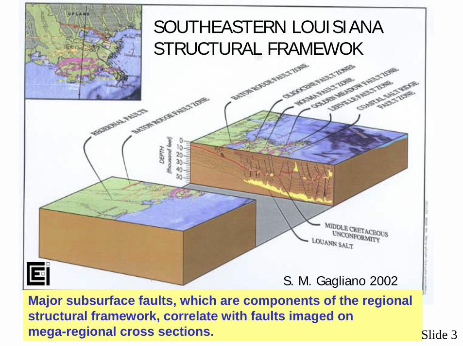
SOUTHEASTERN LOUISIANASTRUCTURAL FRAMEWOK
S. M. Gagliano 2002Major subsurface faults, which are components of the regional structural framework, correlate with faults imaged on mega-regional cross sections. Slide 3
The onshore faults and fractures are part of a linked regional tectonic system that extends into the deep gulf. (Base map with permission of Port Publishing Co., Houston Texas, structural provinces after Peele et al. 1995, fault Gagliano et al. 2003).
SLUM
P
FOLDS
SHELF EDGE
REGIONAL TECTONIC SYSTEMSNORTHERN GULF OF MEXICO
Slide 4
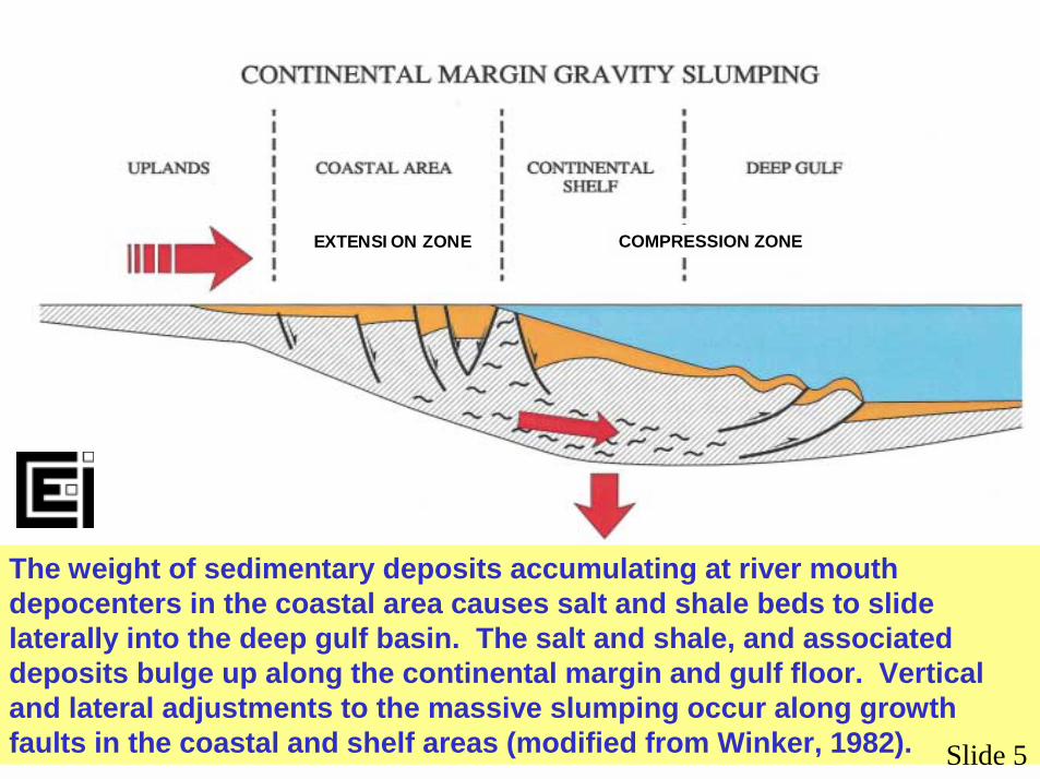
The weight of sedimentary deposits accumulating at river mouth depocenters in the coastal area causes salt and shale beds to slide laterally into the deep gulf basin. The salt and shale, and associated deposits bulge up along the continental margin and gulf floor. Vertical and lateral adjustments to the massive slumping occur along growth faults in the coastal and shelf areas (modified from Winker, 1982).
EXTENSION ZONE COMPRESSION ZONE
Slide 5
Regional growth fault movement is in effect massivegravity slumping along the continental margin.
SLUMP BLOCK MODEL
Slide 6
Small changes in elevation and slope alter large areas in the coastal lowlands. Fault movement may create lakes and bays, alter stream courses, change vegetation, and lower the elevation of ridges, fastlands and barrier islands.
Fault events can usually be dated by identification of first appearance of their distinctive geomorphic signatures on historic maps, aerial photographs and satellite images.
SURFACE EXPRESSION OF FAULTS
Slide 7
SURFACE & SUBSURFACEFAULTS
More than100 suspectedsurface faultshave beenidentified,of which61 correlate withknown subsurfacefaults.
SUSPECTEDSURFACE FAULTS
PROVENSUBSURFACEFAULTS
Slide 8
LAKE BOUDREAUX
EMPIRE &BASTIAN BAY
CASE STUDIES
Slide 9
LAKE BOUDREAUX FAULT
AUGUST 2000MAY 1953
Bayou
Gra
nd C
aillo
u
FAULT LOCATION
Fault trace first became evident in 1971.
FAULT
Slide 10
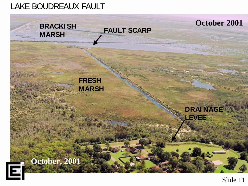
FAULT SCARP
FRESHMARSH
BRACKISHMARSH
DRAINAGELEVEE
LAKE BOUDREAUX FAULT
October 2001
October, 2001
Slide 11
Section based on borings taken across suspected Lake Boudreaux Fault (ET-1) showing elevation, water depths and near - surface stratification. The section shows 3.3 ft (1.0 m) of change in elevation from the marsh surface to the pond bottom and a 1.8 ft (0.55 m) of displacement of the top of the bed identified as “1.” The section is based on data from vibracore and McCauley borings by CEI in 2001. Slide 12
LAKE BOUDREAUX FAULT
October 2001
FAULT SCARPLAKE BOUDREAUX
DEAD CYPRESSFAULT SCARP
FAULT LAKE
Slide 13
WEST PLAQUEMINES DELTAIC PLAIN
1945
Fault movement along the Empire and Bastian BayFaults caused submergence of large areas of salt marsh and created new bays.
Pete Hebert’s camp was originally built on the bank of Bayou Farrand in the late 1960s. The camp is located one mile south of the Bastian Bay Faultscarp. The land that the camp was built on is now completely submerged and the elevation of the building has been reduced 4 to 4.5 ft, apparently as a result of fault movement in the mid 1970s.
2001
Slide 16
x X’
EM
PIR
E F
AU
LT
Unit Area Avg. depth VolumeA - 4,550 ac - 2.5 ft - 18.4 M cu ydsB - 2,870 ac - 1.5 ft - 7.0 M cu ydsC - 940 ac - 1.0 ft - 2.4 M cu ydsD - 4,030 ac - 0.5 ft - 3.3 M cu yds
Total – 12,390 ac - 31.2 M cu yds
EFFECTS OF EMPIRE FAULT1976 – 1978
•Scarp – 5 mi long•Maximum vertical displacement
along scarp – 3.5 ft•Radius of deformation – 3.7 mi•“D”-shaped zone of deformation
•Change in slope•Submergence of marshes & ridges•Altered hydrology•Altered fauna and flora
Fault events drivea succession of landform and environmental change. A brownmarsh stage is characteristicof fault eventsin salt marsh.
BROWN MARSH
Slide 18
LAKE ENFERMER FAULT
March 2001
Brown marsh on down-dropped fault block.
Spartina alternifloraFault
“Brown marsh”
Slide 19
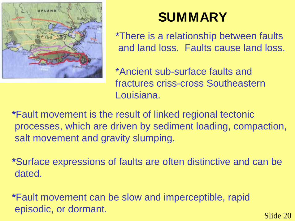
SUMMARY*There is a relationship between faults and land loss. Faults cause land loss.
*Ancient sub-surface faults and fractures criss-cross Southeastern Louisiana.
*Fault movement is the result of linked regional tectonic processes, which are driven by sediment loading, compaction, salt movement and gravity slumping.
*Surface expressions of faults are often distinctive and can be dated.
*Fault movement can be slow and imperceptible, rapidepisodic, or dormant.
Slide 20
SUMMARY - CONTINUED*Fault movement changes surface elevation and slope.
*Fault movement can alter fauna, flora, hydrology and water chemistry.
*Surface features such as wetlands, natural levees, barrier islands, fastlands, etc., are affected by fault movement.
*Rate of vertical movement on active faults ranges from 0.005 to 0.04 ft/yr.
*Fault movement is an underrated natural hazard in Southeastern Louisiana.