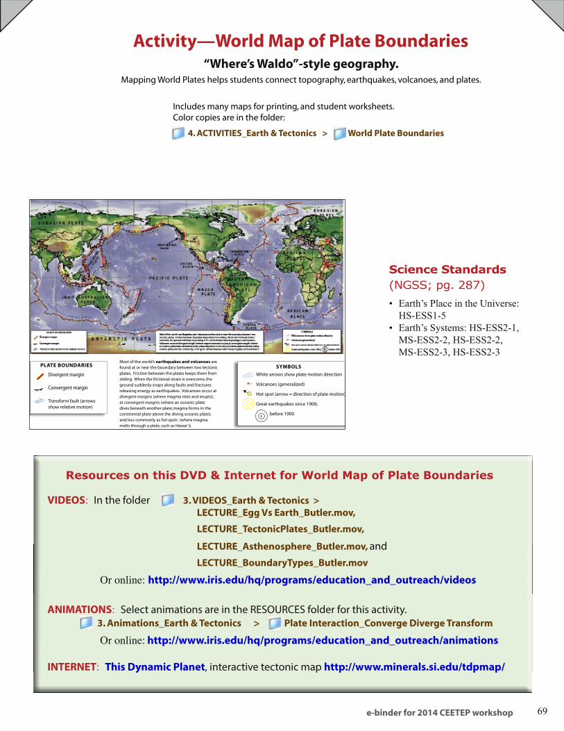
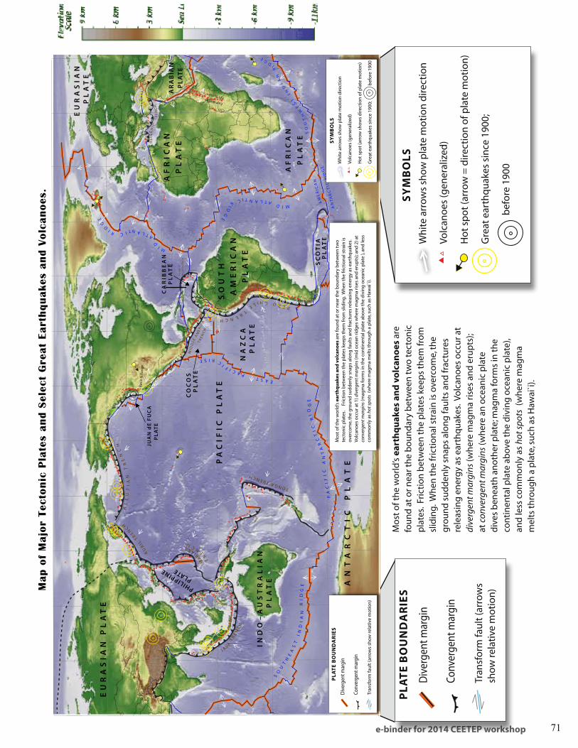
e-binder for 2014 CEETEP workshop 69 Includes many maps for printing, and student worksheets. Color copies are in the folder: 4. ACTIVITIES_Earth & Tectonics > World Plate Boundaries Activity—World Map of Plate Boundaries “Where’s Waldo”-style geography. Mapping World Plates helps students connect topography, earthquakes, volcanoes, and plates. VIDEOS: In the folder 3. VIDEOS_Earth & Tectonics > LECTURE_Egg Vs Earth_Butler.mov, LECTURE_TectonicPlates_Butler.mov, LECTURE_Asthenosphere_Butler.mov, and LECTURE_BoundaryTypes_Butler.mov Or online: http://www.iris.edu/hq/programs/education_and_outreach/videos ANIMATIONS: Select animations are in the RESOURCES folder for this activity. 3. Animations_Earth & Tectonics > Plate Interaction_Converge Diverge Transform Or online: http://www.iris.edu/hq/programs/education_and_outreach/animations INTERNET: This Dynamic Planet, interactive tectonic map http://www.minerals.si.edu/tdpmap/ Resources on this DVD & Internet for World Map of Plate Boundaries Science Standards (NGSS; pg. 287) Earth’s Place in the Universe: • HS-ESS1-5 Earth’s Systems: HS-ESS2-1, • MS-ESS2-2, HS-ESS2-2, MS-ESS2-3, HS-ESS2-3 SYMBOLS White arrows show plate motion direction Volcanoes (generalized) Hot spot (arrow = direction of plate motion) Great earthquakes since 1900; before 1900 Divergent margin Convergent margin Transform fault (arrows show relative motion) PLATE BOUNDARIES Most of the world’s earthquakes and volcanoes are found at or near the boundary between two tectonic plates. Friction between the plates keeps them from sliding. When the frictional strain is overcome, the ground suddenly snaps along faults and fractures releasing energy as earthquakes. Volcanoes occur at divergent margins (where magma rises and erupts); at convergent margins (where an oceanic plate dives beneath another plate; magma forms in the continental plate above the diving oceanic plate), and less commonly as hot spots (where magma melts through a plate, such as Hawai`i).
Transcript
e-binder for 2014 CEETEP workshop 69
Includes many maps for printing, and student worksheets. Color copies are in the folder:
4. ACTIVITIES_Earth & Tectonics > World Plate Boundaries
Activity—World Map of Plate Boundaries“Where’s Waldo”-style geography.
Mapping World Plates helps students connect topography, earthquakes, volcanoes, and plates.
VIDEOS: In the folder 3. VIDEOS_Earth & Tectonics > LECTURE_Egg Vs Earth_Butler.mov,
Or online: http://www.iris.edu/hq/programs/education_and_outreach/videos
ANIMATIONS: Select animations are in the RESOURCES folder for this activity. 3. Animations_Earth & Tectonics > Plate Interaction_Converge Diverge Transform
Or online: http://www.iris.edu/hq/programs/education_and_outreach/animations
INTERNET: This Dynamic Planet, interactive tectonic map http://www.minerals.si.edu/tdpmap/
Resources on this DVD & Internet for World Map of Plate Boundaries
Science Standards (NGSS; pg. 287)
Earth’s Place in the Universe: • HS-ESS1-5Earth’s Systems: HS-ESS2-1, • MS-ESS2-2, HS-ESS2-2, MS-ESS2-3, HS-ESS2-3
SYMBOLS
White arrows show plate motion direction
Volcanoes (generalized)
Hot spot (arrow = direction of plate motion)
Great earthquakes since 1900;
before 1900
Divergent margin
Convergent margin
Transform fault (arrows show relative motion)
PLATE BOUNDARIESMost of the world’s earthquakes and volcanoes are found at or near the boundary between two tectonic plates. Friction between the plates keeps them from sliding. When the frictional strain is overcome, the ground suddenly snaps along faults and fractures releasing energy as earthquakes. Volcanoes occur at divergent margins (where magma rises and erupts); at convergent margins (where an oceanic plate dives beneath another plate; magma forms in the continental plate above the diving oceanic plate), and less commonly as hot spots (where magma melts through a plate, such as Hawai`i).
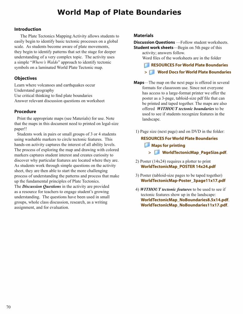
The Plate Tectonics Mapping Activity allows students to easily begin to identify basic tectonic processes on a global scale. As students become aware of plate movements, they begin to identify patterns that set the stage for deeper understanding of a very complex topic. The activity uses a simple “Where’s Waldo” approach to identify tectonic symbols on a laminated World Plate Tectonic map.
Objectives
Learn where volcanoes and earthquakes occurUnderstand geographyUse critical thinking to find plate boundariesAnswer relevant discussion questions on worksheet
Procedure
Print the appropriate maps (see Materials) for use. Note that the maps in this document need to printed on legal-size paper!!
Students work in pairs or small groups of 3 or 4 students using washable markers to circle tectonic features. This hands-on activity captures the interest of all ability levels. The process of exploring the map and drawing with colored markers captures student interest and creates curiosity to discover why particular features are located where they are. As students work through simple questions on the activity sheet, they are then able to start the more challenging process of understanding the patterns and process that make up the fundamental principles of Plate Tectonics. The Discussion Questions in the activity are provided as a resource for teachers to engage student’s growing understanding. The questions have been used in small groups, whole class discussion, research, as a writing assignment, and for evaluation.
Materials
Discussion Questions —Follow student worksheets.Student work sheets—Begin on 5th page of this
activity; answers follow. Word files of the worksheets are in the folder
RESOURCES For World Plate Boundaries
> Word Docs for World Plate Boundaries
Maps—The map on the next page is offered in several formats for classroom use. Since not everyone has access to a large-format printer we offer the poster as a 3-page, tabloid-size pdf file that can be printed and taped together. The maps are also offered WITHOUT tectonic boundaries to be used to see if students recognize features in the landscape.
1) Page size (next page) and on DVD in the folder: RESOURCES For World Plate Boundaries
Maps for printing
> WorldTectonicMap_PageSize.pdf.
2) Poster (14x24) requires a plotter to print WorldTectonicMap_POSTER 14x24.pdf
3) Poster (tabloid-size pages to be taped together) WorldTectonicMap-Poster_3page11x17.pdf
4) WITHOUT tectonic features to be used to see if tectonic features show up in the landscape: WorldTectonicMap_NoBoundaries8.5x14.pdf. WorldTectonicMap_NoBoundaries11x17.pdf.
World Map of Plate Boundaries
e-binder for 2014 CEETEP workshop 71
TONGA TRENCH
MA
RIANA
TR
ENCH
KU
RIL
TREN
CH
AL
EU
TI
AN
T
RE
NC
H
PA
CIF
IC P
LA
TE
SO
UT
H
AM
ER
ICA
N
PL
AT
EN
AZ
CA
P
LA
TE
IND
O–
AU
ST
RA
LIA
N
PL
AT
E AN
TA
RC
TI
C
PL
AT
E
CA
RIB
BE
AN
PL
AT
E
CO
CO
S
PL
AT
E
SC
OT
IA
PL
AT
E
PHILIPPINE
PLATE
JU
AN
dE
FU
CA
P
LAT
E
EU
RA
SIA
N P
LA
TE
EU
RA
SIA
N P
LA
TE
AF
RIC
AN
PL
AT
E
AF
RIC
AN
PL
AT
E
AR
AB
IAN
PLA
TE
EAST PACIFIC RISE
PA
CI
FI
C
AN
TA
RC
TI
C
RI
DG
E
SO
UT
HE
AS
T
IN
DI
AN
R
ID
GE
J A VA T
RE N
CH
PERU CHILE TRENCH
MID ATLANTIC R
ID
GE
MID
ATLANTIC RID
GE
SO
UT
HW
ES
T
IN
DIA
N
R
IDG
E
AM
ER
ICA
N
AN
TA
RC
TIC
RID
GE
HE
LL
EN
IC
TR
EN
CH
MID
DL E
AM
ERI C
ATR
ENC
H
PU
ER
TO
R
ICO
TR
EN
CH
CENTRAL INDIAN RIDGE
Basi
n &
Ran
ge
East African Rift System
Mo
un
tain
s &
val
leys
Spre
adin
g c
ente
r—Fa
stSp
read
ing
cen
ter—
Slo
wD
iver
gent
bou
ndar
ies
occu
r mos
tly
alon
g sp
read
ing
cent
ers
whe
re th
e m
agm
a ris
es fo
rmin
g ne
w c
rust
. (E
x. E
ast P
acifi
c Ri
se, M
id A
tlant
ic
Ridg
e.)
Spre
adin
g zo
nes
(no
grap
hic)
on
cont
inen
ts c
reat
e pa
ralle
l mou
ntai
ns
and
valle
ys a
s th
e cr
ust p
ulls
apa
rt
( ex:
Bas
in &
Ran
ge,
U.S
. an
d t
he
Gre
at R
ift V
alle
y, A
fric
a. )
Div
erg
ent
Bo
un
dar
ies
& S
pre
adin
g Z
on
es
Lit
ho
sph
ere
Ast
he
no
sph
ere
Oc
ea
nic
cru
st
Ma
ntl
e
Part
ial m
elt
As
the
no
sp
he
re
Cru
st
Ma
ntl
eL
ith
os
ph
ere
Part
ial m
elt
Co
nve
rgen
t B
ou
nd
arie
sTr
ansf
orm
Bo
un
dar
ies
Mountain
Range
Old
oceanic
cru
st
Co
nti
ne
nta
l c
rust
Hig
hP
late
au
Co
nti
ne
nta
l c
rust
Lit
ho
sph
ere
Lit
ho
sph
ere
Ast
he
no
sph
ere
Trench
Oce
an
ic c
rust
Co
nti
ne
nta
l
cru
st
Lit
ho
sp
he
reL
ith
os
ph
ere
As
the
no
sp
he
re
As
the
no
sp
he
re
Island arc
Oc
ea
nic
cru
st
Wh
en t
wo
pla
tes
mov
e to
war
d e
ach
oth
er, c
rust
is d
estr
oyed
as
on
e p
late
div
es (i
s su
bd
uct
ed) b
enea
th
the
oth
er. T
he
loca
tio
n w
her
e si
nki
ng
of a
pla
te o
ccu
rs is
cal
led
a s
ub
du
ctio
n z
on
e.A
s su
rro
un
din
g p
late
s ar
e d
rive
n b
y d
eep
forc
es
to m
ove
apar
t o
r cru
nch
to
get
her
, th
e in
-bet
wee
n
area
s ar
e p
ush
ed a
rou
nd
o
n t
he
surf
ace.
Th
is fo
rces
th
em to
slid
e p
ast
each
o
ther
ho
rizo
nta
lly.
Oce
an-O
cean
—O
cean
pla
te d
ives
b
enea
th a
no
ther
oce
an p
late
; vo
lcan
ic is
lan
d c
hai
n f
orm
s ab
ove
the
zon
e (e
x:. T
he
Mar
ian
as)
Tran
sfo
rm fa
ult
s ar
e w
her
e tw
o
pla
tes
are
mov
ing
aw
ay fr
om
a
spre
adin
g r
idg
e an
d fr
actu
re
zon
es d
evel
op
(ex:
oce
an fl
oo
r)
Oce
an-C
on
tin
ent:
Oce
an p
late
div
es
ben
eath
a c
on
tin
enta
l pla
te. V
olc
anic
m
ou
nta
in c
hai
n fo
rms
inla
nd
. (e
x:. C
asca
de
Ran
ge,
Su
mat
ra, J
apan
)
Co
nti
nen
t-C
on
tin
ent:
Tw
o t
hic
k co
nti
nen
tal p
late
s co
llid
e an
d b
uck
le
into
hig
h m
ou
nta
ins.
(e
x: H
imal
aya
Mo
un
tain
Ran
ge.
)
Ast
heno
sphe
re
Cru
st
Lith
osp
here
Ast
he
no
sph
ere
Cru
st
Tra
nsf
orm
fa
ult
Lit
ho
sph
ere
Spre
adin
g
r
idge
Part
ial m
elt
Spre
adin
g
r
idge
Stri
ke s
lip fa
ult
s re
sult
fro
m
two
pla
tes
mov
ing
ho
rizo
nta
lly
in o
pp
osi
te d
irec
tio
ns
(e
x: S
an A
nd
reas
Fau
lt, C
alifo
rnia
).
Div
erge
nt m
argi
n
Conv
erge
nt m
argi
n
Tran
sfo
rm fa
ult
(arr
ow
s sh
ow
rela
tive
mo
tio
n)
PL
AT
E B
OU
ND
AR
IES
SY
MB
OL
S
Wh
ite
arro
ws
sho
w p
late
mo
tio
n d
irec
tio
n
Volc
ano
es (g
ener
aliz
ed)
Ho
t sp
ot
(arr
ow
sh
ow
s d
irec
tio
n o
f pla
te m
oti
on
)
Gre
at e
arth
qu
akes
sin
ce 1
900;
b
efo
re 1
900
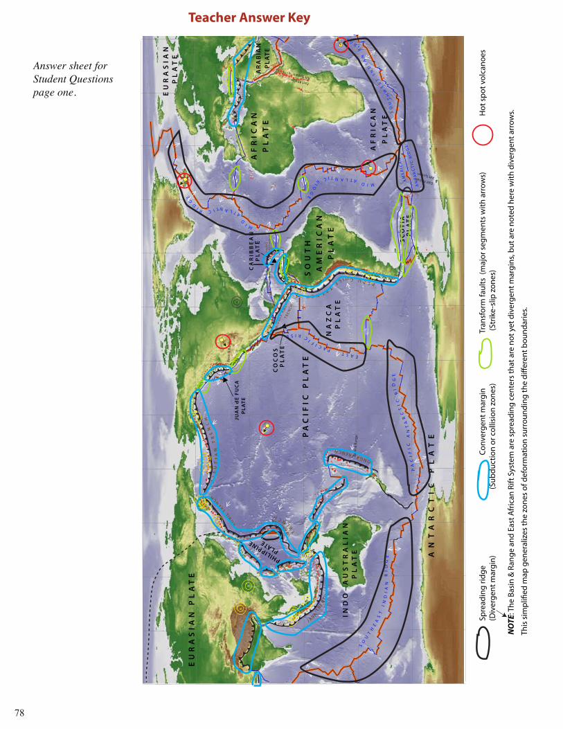
Map o
f M
ajo
r Te
cton
ic P
late
s an
d S
elec
t G
reat
Eart
hqu
akes
an
d V
olc
an
oes
.
Back
grou
nd m
ap c
ourt
esty
of S
cott
Wal
ker (
Dig
ital C
arto
grap
hy S
peci
alis
t, H
arva
rd C
olle
ge L
ibra
ry);
gra
phic
s and
tect
onic
& v
olcc
anic
feat
ures
by
Jend
a Jo
hnso
n (V
olca
no V
ideo
& G
raph
ics)
Trench
Co
nti
ne
nta
l
cru
st
Lit
ho
sph
ere
Lit
ho
sph
ere
Ast
he
no
sph
ere
Volcanic arc.
.
..
..
..
..
..
..
..
..
. .
Oc
ea
nic
cru
st
Mo
st o
f th
e w
orl
d’s
eart
hq
uak
es a
nd
vo
lcan
oes
are
fou
nd
at
or n
ear t
he
bo
un
dar
y b
etw
een
tw
o
tect
on
ic p
late
s.
Fri
ctio
n b
etw
een
th
e p
late
s ke
eps
them
fro
m s
lidin
g. W
hen
th
e fr
icti
on
al s
trai
n is
ov
erco
me,
th
e g
rou
nd
su
dd
enly
sn
aps
alo
ng
fau
lts
and
frac
ture
s re
leas
ing
en
erg
y as
ear
thq
uak
es.
Vo
lcan
oes
occ
ur a
t 1)
div
erge
nt m
argi
ns (m
id o
cean
rid
ges
wh
ere
mag
ma
rise
s an
d e
rup
ts);
and
2) a
t co
nver
gent
mar
gins
(mag
ma
form
s in
th
e co
nti
nen
tal p
late
ab
ove
the
div
ing
oce
anic
pla
te ),
an
d le
ss
com
mo
nly
as
hot s
pots
(w
her
e m
agm
a m
elts
th
rou
gh
a p
late
, su
ch a
s H
awai
`i).
TONGA TRENCH
MA
RIANA
TR
ENCH
KU
RIL
TREN
CH
AL
EU
TI
AN
T
RE
NC
H
PA
CIF
IC P
LA
TE
SO
UT
H
AM
ER
ICA
N
PL
AT
EN
AZ
CA
P
LA
TE
IND
O–
AU
ST
RA
LIA
N
PL
AT
E AN
TA
RC
TI
C
PL
AT
E
CA
RIB
BE
AN
PL
AT
E
CO
CO
S
PL
AT
E
SC
OT
IA
PL
AT
E
PHILIPPINE
PLATE
JU
AN
dE
FU
CA
P
LAT
E
EU
RA
SIA
N P
LA
TE
EU
RA
SIA
N P
LA
TE
AF
RIC
AN
PL
AT
E
AF
RIC
AN
PL
AT
E
AR
AB
IAN
PLA
TE
EAST PACIFIC RISE
PA
CI
FI
C
AN
TA
RC
TI
C
RI
DG
E
SO
UT
HE
AS
T
IN
DI
AN
R
ID
GE
J A VA T
RE N
CH
PERU CHILE TRENCH
MID ATLANTIC R
ID
GE
MID
ATLANTIC RID
GE
SO
UT
HW
ES
T
IN
DIA
N
R
IDG
E
AM
ER
ICA
N
AN
TA
RC
TIC
RID
GE
HE
LL
EN
IC
TR
EN
CH
MID
DL E
AM
ERI C
ATR
ENC
H
PU
ER
TO
R
ICO
TR
EN
CH
CENTRAL INDIAN RIDGE
Basi
n &
Ran
ge
East African Rift System
Mo
un
tain
s &
val
leys
Spre
adin
g c
ente
r—Fa
stSp
read
ing
cen
ter—
Slo
wD
iver
gent
bou
ndar
ies
occu
r mos
tly
alon
g sp
read
ing
cent
ers
whe
re th
e m
agm
a ris
es fo
rmin
g ne
w c
rust
. (E
x. E
ast P
acifi
c Ri
se, M
id A
tlant
ic
Ridg
e.)
Spre
adin
g zo
nes
(no
grap
hic)
on
cont
inen
ts c
reat
e pa
ralle
l mou
ntai
ns
and
valle
ys a
s th
e cr
ust p
ulls
apa
rt
(ex:
Bas
in &
Ran
ge,
U.S
. an
d t
he
Gre
at R
ift V
alle
y, A
fric
a. )
Div
erg
ent
Bo
un
dar
ies
& S
pre
adin
g Z
on
es
Lit
ho
sph
ere
Ast
he
no
sph
ere
Oc
ea
nic
cru
st
Ma
ntl
e
Part
ial m
elt
As
the
no
sp
he
re
Cru
st
Ma
ntl
eL
ith
os
ph
ere
Part
ial m
elt
Co
nve
rgen
t B
ou
nd
arie
sTr
ansf
orm
Bo
un
dar
ies
Mountain
Range
Old
oceanic
cru
st
Co
nti
ne
nta
l c
rust
Hig
hP
late
au
Co
nti
ne
nta
l c
rust
Lit
ho
sph
ere
Lit
ho
sph
ere
Ast
he
no
sph
ere
Trench
Oce
an
ic c
rust
Co
nti
ne
nta
l
cru
st
Lit
ho
sp
he
reL
ith
os
ph
ere
As
the
no
sp
he
re
As
the
no
sp
he
re
Island arc
Oc
ea
nic
cru
st
Wh
en t
wo
pla
tes
mov
e to
war
d e
ach
oth
er, c
rust
is d
estr
oyed
as
on
e p
late
div
es (i
s su
bd
uct
ed) b
enea
th
the
oth
er. T
he
loca
tio
n w
her
e si
nki
ng
of a
pla
te o
ccu
rs is
cal
led
a s
ub
du
ctio
n z
on
e.A
s su
rro
un
din
g p
late
s ar
e d
rive
n b
y d
eep
forc
es
to m
ove
apar
t o
r cru
nch
to
get
her
, th
e in
-bet
wee
n
area
s ar
e p
ush
ed a
rou
nd
o
n t
he
surf
ace.
Th
is fo
rces
th
em to
slid
e p
ast
each
o
ther
ho
rizo
nta
lly.
Oce
an-O
cean
—O
cean
pla
te d
ives
b
enea
th a
no
ther
oce
an p
late
; vo
lcan
ic is
lan
d c
hai
n f
orm
s ab
ove
the
zon
e (e
x:. T
he
Mar
ian
as)
Tran
sfo
rm fa
ult
s ar
e w
her
e tw
o
pla
tes
are
mov
ing
aw
ay fr
om
a
spre
adin
g r
idg
e an
d fr
actu
re
zon
es d
evel
op
(ex:
oce
an fl
oo
r)
Oce
an-C
on
tin
ent:
Oce
an p
late
div
es
ben
eath
a c
on
tin
enta
l pla
te. V
olc
anic
m
ou
nta
in c
hai
n fo
rms
inla
nd
. (e
x:. C
asca
de
Ran
ge,
Su
mat
ra, J
apan
)
Co
nti
nen
t-C
on
tin
ent:
Tw
o t
hic
k co
nti
nen
tal p
late
s co
llid
e an
d b
uck
le
into
hig
h m
ou
nta
ins.
(e
x: H
imal
aya
Mo
un
tain
Ran
ge.
)
Ast
heno
sphe
re
Cru
st
Lith
osp
here
Ast
he
no
sph
ere
Cru
st
Tra
nsf
orm
fa
ult
Lit
ho
sph
ere
Spre
adin
g
r
idge
Part
ial m
elt
Spre
adin
g
r
idge
Stri
ke s
lip fa
ult
s re
sult
fro
m
two
pla
tes
mov
ing
ho
rizo
nta
lly
in o
pp
osi
te d
irec
tio
ns
(e
x: S
an A
nd
reas
Fau
lt, C
alifo
rnia
).
Div
erge
nt m
argi
n
Conv
erge
nt m
argi
n
Tran
sfo
rm fa
ult
(arr
ow
s sh
ow
rela
tive
mo
tio
n)
PL
AT
E B
OU
ND
AR
IES
SY
MB
OL
S
Wh
ite
arro
ws
sho
w p
late
mo
tio
n d
irec
tio
n
Volc
ano
es (g
ener
aliz
ed)
Ho
t sp
ot
(arr
ow
sh
ow
s d
irec
tio
n o
f pla
te m
oti
on
)
Gre
at e
arth
qu
akes
sin
ce 1
900;
b
efo
re 1
900
Map o
f M
ajo
r Te
cton
ic P
late
s an
d S
elec
t G
reat
Eart
hqu
akes
an
d V
olc
an
oes
.
Back
grou
nd m
ap c
ourt
esty
of S
cott
Wal
ker (
Dig
ital C
arto
grap
hy S
peci
alis
t, H
arva
rd C
olle
ge L
ibra
ry);
gra
phic
s and
tect
onic
& v
olcc
anic
feat
ures
by
Jend
a Jo
hnso
n (V
olca
no V
ideo
& G
raph
ics)
Trench
Co
nti
ne
nta
l
cru
st
Lit
ho
sph
ere
Lit
ho
sph
ere
Ast
he
no
sph
ere
Volcanic arc
..
..
..
..
..
..
..
..
..
. .
Oc
ea
nic
cru
st
Mo
st o
f th
e w
orl
d’s
eart
hq
uak
es a
nd
vo
lcan
oes
are
fou
nd
at
or n
ear t
he
bo
un
dar
y b
etw
een
tw
o
tect
on
ic p
late
s.
Fri
ctio
n b
etw
een
th
e p
late
s ke
eps
them
fro
m s
lidin
g. W
hen
th
e fr
icti
on
al s
trai
n is
ov
erco
me,
th
e g
rou
nd
su
dd
enly
sn
aps
alo
ng
fau
lts
and
frac
ture
s re
leas
ing
en
erg
y as
ear
thq
uak
es.
Vo
lcan
oes
occ
ur a
t 1)
div
erge
nt m
argi
ns (m
id o
cean
rid
ges
wh
ere
mag
ma
rise
s an
d e
rup
ts);
and
2) a
t co
nver
gent
mar
gins
(mag
ma
form
s in
th
e co
nti
nen
tal p
late
ab
ove
the
div
ing
oce
anic
pla
te ),
an
d le
ss
com
mo
nly
as
hot s
pots
(w
her
e m
agm
a m
elts
th
rou
gh
a p
late
, su
ch a
s H
awai
`i).
SY
MB
OL
S
Wh
ite
arro
ws
sho
w p
late
mo
tio
n d
irec
tio
n
Volc
ano
es (g
ener
aliz
ed)
Ho
t sp
ot
(arr
ow
= d
irec
tio
n o
f pla
te m
oti
on
)
Gre
at e
arth
qu
akes
sin
ce 1
900;
bef
ore
190
0
Div
erge
nt m
argi
n
Conv
erge
nt m
argi
n
Tran
sfo
rm fa
ult
(arr
ow
s sh
ow
rela
tive
mo
tio
n)
PL
AT
E B
OU
ND
AR
IES
Mo
st o
f th
e w
orl
d’s
eart
hq
uak
es a
nd
vo
lcan
oes
are
fo
un
d a
t o
r nea
r th
e b
ou
nd
ary
bet
wee
n t
wo
tect
on
ic
pla
tes.
Fri
ctio
n b
etw
een
th
e p
late
s ke
eps
them
fro
m
slid
ing.
Wh
en t
he
fric
tio
nal
str
ain
is o
verc
om
e, t
he
gro
un
d s
ud
den
ly s
nap
s al
on
g fa
ult
s an
d fr
actu
res
rele
asin
g e
ner
gy
as e
arth
qu
akes
. Vo
lcan
oes
occ
ur a
t di
verg
ent m
argi
ns (w
her
e m
agm
a ri
ses
and
eru
pts
); at
con
verg
ent m
argi
ns (w
her
e an
oce
anic
pla
te
div
es b
enea
th a
no
ther
pla
te; m
agm
a fo
rms
in t
he
con
tin
enta
l pla
te a
bov
e th
e d
ivin
g o
cean
ic p
late
), an
d le
ss c
om
mo
nly
as
hot s
pots
(w
her
e m
agm
a m
elts
th
rou
gh
a p
late
, su
ch a
s H
awai
`i).
72
Mountains & valleys
Spreading center—Fast Spreading center—SlowDivergent boundaries occur mostly along spreading centers where the magma rises forming new crust. (Ex. East Pacific Rise, Mid Atlantic Ridge.)
Spreading zones (no graphic) on continents create parallel mountains and valleys as the crust pulls apart (ex: Basin & Range, U.S. and the Great Rift Valley, Africa. )
Divergent Boundaries & Spreading Zones
Lithosphere
Asthenosphere
Oceanic crust
Mantle
Partial meltAsthenosphere
Crust
MantleL ithosphere
Partial melt
Convergent Boundaries
Mo
un
tain
Ran
ge
Old oceanic crust
Cont inental crust
HighPlateau
Continental crust
L i thosphere Lithosphere
Asthenosphere
Trench
Oceanic crust
Cont inental c rust
L i thosphere Lithosphere
Asthenosphere
Asthenosphere
Isla
nd
arc
Oceanic crust
When two plates move toward each other, crust is destroyed as one plate dives (is subducted) beneath the other. The location where sinking of a plate occurs is called a subduction zone.
Ocean-Ocean—Ocean plate dives beneath another ocean plate; volcanic island chain forms above the zone (ex:. The Marianas)
Ocean-Continent: Ocean plate dives beneath a continental plate. Volcanic mountain chain forms inland. (ex:. Cascade Range, Sumatra, Japan)
Continent-Continent: Two thick continental plates collide and buckle into high mountains. (ex: Himalaya Mountain Range.)
Trench
Cont inental c rust
L i thosphere Lithosphere
Asthenosphere
Vo
lca
nic
a
rc
..
..
..
........
..
.. . .
Oceanic crust
Transform BoundariesAs surrounding plates are driven by deep forces to move apart or crunch together, the in-between areas are pushed around on the surface. This forces them to slide past each other horizontally.
Transform faults are where two plates are moving away from a spreading ridge and fracture zones develop (ex: ocean floor)
Asthenosphere
Crust
L i thosphere
Asthenosphere
Crust
Transform fault
L i thosphere
Spreading ridge
Partial melt
Spreading ridge
Strike slip faults result from two plates moving horizontally in opposite directions (ex: San Andreas Fault, California).
1. Draw the symbol for each tectonic feature in the chart below
Divergent margins and spreading centers (draw in black)
Convergent margins - subduction zone (draw in blue)
Transform faults – strike-slip faults (draw in green)
Hot Spot (draw in red)
2. Use the correct color of washable marker to locate each tectonic feature on the map. a. Circle the name of the Divergent boundary systems in black. (Ridges and Rises) Number found _______
b. Circle the Convergent margins in blue. (students may circle individual trenches) Number found _______ c. Circle the Transform fault symbols (and their faults) in green. Number found _______
d. Circle the Hot Spots in red. Number found _______
3. What is the name of the small crustal plate off the Oregon coast that is subducting under the North American plate? _______________________
4. Where are most of the earthquakes and volcanoes located?
Check one: a. crustal plate margins _____ b. interior of a crustal plate _____
Answer the following questions about Plate Tectonic Processes using the diagrams with the map.
5. Divergent margins and continental spreading centers:
a. New crust forms at plate margins as ___________ rises creating ridges under
oceans such as the _____________________ and the ____________________.
74
b. Continental spreading centers include the __________________ in the US and the _______________________ in Africa.
6. Convergent margins – subduction zones:
Identify the land form (geomorphology) created at each type of Convergent Boundary and provide an example.
a. Sometimes tectonic plates shift past each other horizontally ________________ directions at their boundary.
b. One example of a strike slip fault near San Francisco is the _________________.
8. Earthquakes:
Most earthquakes occur near plate _____________.a.
_____________ keeps the plate edges from sliding smoothly past each other.b.
The longer the plates remain stuck, the more strain builds and the more violent c.
the snap and resulting _____________.
9. Volcanoes:
a. Magma rises to the surface from inside the earth mainly at __________________ and _______________________.
Around the rim of the Pacific Ocean, the 40,000 km long ________ of ________ b.
is especially active.
10. Hot Spots:
In a few places _________ melts through a tectonic plate.a.
Each hot spot likely marks the top of a plume of _____________ rock that risesb. from deep in the earth.
Discussion Questions: (italics are guiding ideas on a few random questions.)
Discussion questions can be used in a whole group setting, or selected questions may be assigned to table groups to answer and then shared with the class.
1. Does the location of earthquakes and volcanoes show a pattern? If so, what tectonic process may be responsible? (compression, extension, shearing)
2. Generally speaking, where are the oceanic ridges located with respect to the landmasses? (in the middle of the ocean: heavy thin crust sinks and water fills low areas.)
3. Where do you find the mountain ranges with respect to the oceanic ridges? Use examples. (the ocean-floor ranges are on the crest of the spreading ridges where heat provides the buoyant lift; they sink as they cool.)
4. Are there any places on Earth where the mid-oceanic ridges meet the continent?
5. What are seamounts?
6. Most of the Pacific Ocean is on what plate?
7. What is the compass orientation of the Hawaiian Islands and many of the other smaller ridges within the Pacific Ocean? Is this significant? (the islands are moving away from the hotspot in the direction the plate is traveling. Thus the line of the youngest islands is oriented west-northwest as they move towards Japan)
8. In what compass direction is the Pacific Plate moving? (see previous question)
9. Name the biggest and longest mountain range in the world. What is it? (Trick question. It is a mid-ocean ridge.)
10. Name an island chain that has been formed by a “hot spot”. (see question 7 above. The Hawaiian Islands.)
11.What island in the North Atlantic Ocean is splitting apart? What is causing the split? (Iceland is a hotspot that is straddling the Mid-Atlantic spreading ridge. The spreading ridge is causing the split. If it were just a hotspot it would just build a big edifice.)
12. Where is magma rising to the surface and forming ocean crust? (At spreading ridges) Where is the oceanic crust sinking back into the mantle? (At subduction zones)
13. Some people have referred to the process in the above question as a cycle. Why would it be considered a cycle? (Rock is formed at the spreading ridge; gets destroyed at subduction zones. The subducted rock eventually gets absorbed into the mantle and gets caught in the very slow circulation of rock in the mantle which can melt as it rises to the top again.)
14. What are the attributes of a cycle? Can you describe another cycle that could compare with the example described above.
15. Why is it that the Pacific Ocean floor is no older than about 200 million years and yet the continents are much older? (The ocean floor is being created constantly. It is made of heavy rock that tends to subduct when it meets continental rock. The continents are made of older rock that is more buoyant .
16. The continental margins of the East and West Coast of the United States are very different. Describe the differences. Are there tectonic differences?
17. Where would you expect to find igneous, sedimentary and metamorphic rocks?
76
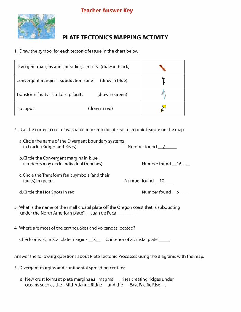
PLATE TECTONICS MAPPING ACTIVITY
1. Draw the symbol for each tectonic feature in the chart below
Divergent margins and spreading centers (draw in black)
Convergent margins - subduction zone (draw in blue)
Transform faults – strike-slip faults (draw in green)
Hot Spot (draw in red)
2. Use the correct color of washable marker to locate each tectonic feature on the map. a. Circle the name of the Divergent boundary systems in black. (Ridges and Rises) Number found __7_____
b. Circle the Convergent margins in blue. (students may circle individual trenches) Number found __16 +__ c. Circle the Transform fault symbols (and their faults) in green. Number found __10____
d. Circle the Hot Spots in red. Number found __5____
3. What is the name of the small crustal plate off the Oregon coast that is subducting under the North American plate? __Juan de Fuca_________
4. Where are most of the earthquakes and volcanoes located?
Check one: a. crustal plate margins __X__ b. interior of a crustal plate _____
Answer the following questions about Plate Tectonic Processes using the diagrams with the map.
5. Divergent margins and continental spreading centers:
a. New crust forms at plate margins as _magma___ rises creating ridges under oceans such as the _Mid-Atlantic Ridge__ and the __East Pacific Rise__.
Teacher Answer Key
e-binder for 2014 CEETEP workshop 77
Teacher Answer Key
b. Continental spreading centers include the _Basin and Range__ in the US and the _East African Rift System in Africa.
6. Convergent margins – subduction zones:
Identify the land form (geomorphology) created at each type of Convergent Boundary and provide an example.
Ocean-Ocean _____a. Volcanic Island Chain (Mariana trench)________