International Institute for Environment and Development Bangladesh Centre for Advanced Studies The RING alliance of policy research organisations C LACC Working Paper No. 1 Bangladesh CAPACITY STRENGTHENING IN THE LEAST DEVELOPED COUNTRIES (LDCs) FOR ADAPTATION TO CLIMATE CHANGE (CLACC) ADVERSE IMPACTS OF CLIMATE CHANGE ON DEVELOPMENT OF BANGLADESH: INTEGRATING ADAPTATION INTO POLICIES AND ACTIVITIES MOZAHARUL ALAM
Transcript
International Institute for
Environment and Development
Bangladesh Centre for Advanced Studies
The RING alliance of policy research
organisations
C LACC Working Paper No. 1
Bangladesh
CAPACITY STRENGTHENING IN THE LEAST DEVELOPED COUNTRIES (LDCs) FOR
ADAPTATION TO CLIMATE CHANGE (CLACC)
ADVERSE IMPACTS OF CLIMATE CHANGE ON DEVELOPMENT OF BANGLADESH:
INTEGRATING ADAPTATION INTO POLICIES AND ACTIVITIES
MOZAHARUL ALAM
C LACC Working Paper No. 3
Bangladesh
CAPACITY STRENGTHENING IN THE LEAST DEVELOPED COUNTRIES (LDCs) FOR
ADAPTATION TO CLIMATE CHANGE (CLACC)
ADVERSE IMPACTS OF CLIMATE CHANGE ON DEVELOPMENT OF BANGLADESH:
INTEGRATING ADAPTATION INTO POLICIES AND ACTIVITIES
MOZAHARUL ALAM
Bangladesh Centre for advanced Studies (BCAS) House 10, Road 16A, Gulshan-1, Dhaka– 1212
This book is prepared by Mozaharul Alam of Bangladesh under Capacity Strengthening of Least Developed Countries (LDCs) for Adaptation to Climate Change (CLACC) Fellowship programme coordinated by International Institute for Environment and Development (IIED). The analysis and assessment contained herein are the views authors. Bangladesh centre for Advanced Studies (BCAS) and International Institute for Environment and Development (IIEC) encourage the use of material presented herein with appropriate credit given to the authors and publisher.
Authors
Mozaharul Alam
Research Fellow, Bangladesh Centre for Advanced Studies (BCAS), Bangladesh
ii
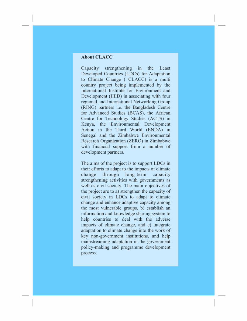
FOREWORD Capacity strengthening in the Least Developed Countries (LDCs) for Adaptation to Climate Change (CLACC) is a multi country project being implemented by the International Institute for Environment and Development (IIED) in association with four regional centres i.e. the Bangladesh Centre for Advanced Studies (BCAS), the African Centre for Technology Studies (ACTS) in Kenya, the Environmental Development Action in the Third World (ENDA) in Senegal and the Zimbabwe E n v i r o n m e n t a l R e s e a r c h O r g a n i s a t i o n ( Z E R O ) i n Zimbabwe with financial support from a number of development partners.
The aim of the project is to support LDCs in their efforts to adapt to the impacts of climate change through long-term capacity strengthening activities with governments as well as civil society. The main objectives of the project are to a) strengthening the capacity of civil society in LDCs to adapt to climate change and enhancing adaptive capacity among the most vulnerable groups; b) establishing an information and knowledge sharing system to help countries to deal with the adverse impacts of climate change; and c) integrating adaptation to climate change into the work of key non-government institutions, and mainstreaming the National Adaptation Programmes of Action (NAPA) process with these institutions.
Fellows from CLACC regional partners have reviewed existing literature on environment and climate change, priority areas of the government, policies and development plans, and programmes and activities for assessing adverse impacts of climate change on development. It has reviewed the present level of activities and policy domain addressing climate change stimuli including variability and extreme events. The assessment has been carried out for 12 countries spread over South Asia, East Africa, West Africa, and Southern Africa. Apart from this, the assessment report has identified gaps and necessary required measures for integrating adaptation in policies in the short, medium, and long-term development activities for addressing adverse climate impacts and reducing vulnerability. The documents used in this assessment are a) initial national communication to UNFCCC, b) reports on climate change impacts, vulnerability and adaptation studies, c) national development policies
Foreword
iii
and plans, d) poverty reduction strategy papers, e) National Adaptation Programme of Action (NAPA) documents, and e) Literature from international sources including UNFCCC IPCC. This assessment report can be used as background material for the preparation of NAPA and mainstreaming adaptation to climate change in other development policies, programme and measures, and to promote sustainable development.
The Report on “Adverse Impacts of Climate Change on Development of Bangladesh : Integrating Adaptation into Policies and Activities” was prepared by Mozaharul Alam, Research Fellow, Bangladesh Centre for Advanced Studies (BCAS) under the CLACC Fellowship Programme. The International Institute for Environment and Development (IIED) has provided the necessary support during the fellowship programme as host institute. Saleemul Huq, and Hannah Reid have provided guidance in the whole process and activities. This was made possible with financial support from the Dexter Trust and Royal Ministry of Foreign Affairs, Norway.
Foreword
iv
Summary
SUMMARY Bangladesh is one of the largest deltas, second to the Amazon, in the world formed mainly by the Ganges-Brahmaputra-Meghna (GBM) river system, except for the hilly regions in the northeast and southeast, and terrace land in northwest and central region. The total land area of Bangladesh is 147,570 sq. km. and consists of low and flat land. Economic emancipation of large population through poverty alleviation is one of the primary targets of development planning and programme of Bangladesh. The national development strategy documents state that Bangladesh has one of the most vulnerable economics, characterised by extremely high population density, low resource base, and high incidence of natural disasters. These have implications for long-term savings, investment, and growth.
There are many driving forces compelling people in Bangladesh to over-exploit natural resources. The main ones are poverty with rapid population growth, improper land use, absence of a land use policy, and ineffective implementation of existing laws and guidelines. Unplanned agricultural practices, and encroachment on forest areas for agriculture and settlements, also put pressure on scarce land resources. Unplanned or inadequate rural infrastructure development and the growing demands of increasing urbanization are also devouring productive land.
Apart from existing challenges, most damaging effects of climate change are floods and droughts that are found to drastically affect crop productivity almost every year. Climate change induced challenges are, a) scarcity of fresh water due to less rain and higher evapotranspiration, b) drainage congestion due to higher water levels in the confluence with the rise of sea level, c) river bank erosion, d) frequent Floods and prolonged and widespread drought, e) wider salinity in the surface, ground and soil. Although Bangladesh is significantly impacted by current climate variability, and is among the countries most vulnerable to climate change, there is no national policy in place yet to comprehensively address climate related risks. However, it is revealed that many government plans and donor project documents in Bangladesh mentioned adverse impact of extreme weather events particularly floods, droughts and cyclones. For example, the National Water
v
Policy (NWP) and National Water Management Plan (NWMP) have suggested measures such as to develop “early warning and flood- proofing systems to manage flood and drought that are expected to increase under climate change. The need for a National Policy on Climate Change has been expressed time and again by the civil society of the country since early 1990s. National Dialogue on Water and Climate Change held in 2003, formulation of a Climate Change Policy for the country was highly recommended. The National Adaptation Programme of Action (NAPA) appears to be the first attempt to bring different stakeholders, including the government and the civil society for preparing a national adaptation strategy to address immediate and urgent need. The involvement of donors and development agencies from the very beginning along with other sectoral agencies will help in mainstreaming adaptation to climate change. In addition, up scaling of the win-win measures that are already being implemented in Bangladesh and continuous persuasion with policy makers would help Bangladesh in mainstreaming adaptation to climate change.
Summary
vi
Acronyms and Abbreviation
ADB Asian Development Bank BBS Bangladesh Bureau of Statistics BBSAP National Biodiversity Strategy and Action Plan CCCM Canadian Climate Change Model CDMP Comprehensive Disaster Management Program DFID Department for International Development FAO Food and Agricultural Organization GBM Ganges-Brahmaputra-Meghna GCM General Circulation Model GDP Gross Domestic Product GEF Global Environment Facility GNI Gross National Income GOB Government of Bangladesh HDI Human Development Index HES Household Expenditure Survey HYV High Yielding Variety IFAD International Fund for Agricultural Development IPCC Intergovernmental Panel on Climate Change I-PRSP Interim Poverty Reduction Strategy Paper LLP Low Lift Pumps MOEF Ministry Environment and Forests NAPA National Adaptation Plan of Action NARS National Agricultural Research System NFoP National Forest Policy NLUP National Land Use Policy NNI Net National Income NWMP National Water Management Plan NWP National Water Policy OECD Organization of Economic Commission and Development RMG Ready Made Garment SMRC SAARC Meteorological Research Centre SRES Special Report on Emission Scenario STW Shallow Tubewells UNFCCC United Nations Framework Convention on Climate Change
Acronyms and Abbreviation
vii
Table of Contents
1 Country Background 1 1.1 Location and Geography 1 1.2 Land and Population 2 1.3 Climatic Condition 3 1.4 Economic Situation 5 1.5 Socio-economic Situation 6 1.6 Resource Endowment and Condition 6 1.6.1 Land and Land Use 7 1.6.2 Water and Water Use 9 1.6.3 Forest 10 1.6.4 Biodiversity 11 1.7 Development Goals and Objectives 11 1.8 Brief Overview of Development Planning in Bangladesh 12 1.9 Development Challenges 14 2 Climate Change, Impacts, Vulnerability and Adaptation 15 2.1 Changes in Temperature, Rainfall and Sea Level 15 2.2 Recent Climate Projection 16 2.2.1 Sea Level Rise 18 2.3 Climate Change Impacts, Vulnerabilities and Adaptation 18 2.3.1 Water Resources 19 2.3.2 Coastal Zone 21 2.3.3 Crop Agriculture and Food Security 23 2.3.4 Forestry and biodiversity 24 2.3.5 Human health 25 2.4 Vulnerability of households 26 2.5 Adaptation Options 28 2.5.1 Physical Measures 28 2.5.2 Soft Measures 30 2.5.3 Institutional Issues 31 3 Mainstreaming Adaptation to Climate Change 33 3.1 Present Policies and Activities 33 3.1.1 Climate Change Concerns in MEAs, Macro Policies and Plans 33 3.1.2 Climate Concerns in Sectoral Policies, Programmes and Projects 35 3.1.3 Climate Concerns in Donor Strategies and Activities 36 3.1.4 Attention to Climate Risks in Selected Development Projects 38 3.2 National Adaptation Programme of Action (NAPA) 39 3.2.1 Priority Sectors 40 3.2.2 Capacity Needs 41 4 Concluding Remarks 42
Table of Contents
viii
1
Country Background
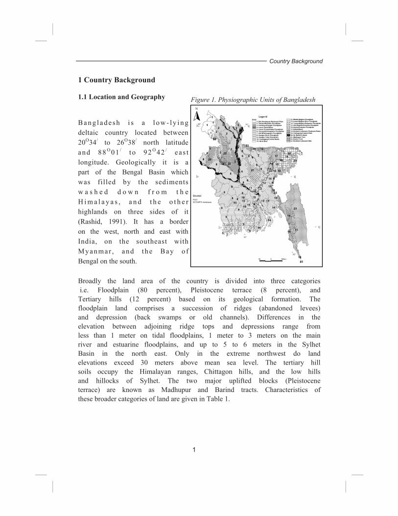
1 Country Background 1.1 Location and Geography
B a n g l a d e sh i s a l o w - l y i n g deltaic country located between 20O34/ to 26O38/ north latitude and 88 O 01 / t o 92 O 42 / eas t longitude. Geologically it is a part of the Bengal Basin which was filled by the sediments w a s h e d d o w n f r o m t h e H i m a l a y a s , a n d t h e o t h e r highlands on three sides of it (Rashid, 1991). It has a border on the west, north and east with India, on the southeast with My anmar , and the Bay o f Bengal on the south. Broadly the land area of the country is divided into three categories i.e. Floodplain (80 percent), Pleistocene terrace (8 percent), and Tertiary hills (12 percent) based on its geological formation. The floodplain land comprises a succession of ridges (abandoned levees) and depression (back swamps or old channels). Differences in the elevation between adjoining ridge tops and depressions range from less than 1 meter on tidal floodplains, 1 meter to 3 meters on the main river and estuarine floodplains, and up to 5 to 6 meters in the Sylhet Basin in the north east. Only in the extreme northwest do land elevations exceed 30 meters above mean sea level. The tertiary hill soils occupy the Himalayan ranges, Chittagon hills, and the low hills and hillocks of Sylhet. The two major uplifted blocks (Pleistocene terrace) are known as Madhupur and Barind tracts. Characteristics of these broader categories of land are given in Table 1.
Figure 1. Physiographic Units of Bangladesh
Table 1. Characteristics of Land Area of Bangladesh
1.2 Land and Population Bangladesh is one of the largest deltas, second to the Amazon, in the world formed mainly by the Ganges-Brahmaputra-Meghna (GBM) river system, except for the hilly regions in the northeast and southeast, and terrace land in northwest and central region. The total land area of Bangladesh is 147,570 sq. km. and consists of low and flat land. A network of rivers with their tributaries and distributaries crisscross the country and therefore virtually it is a conglomerate of islands. It has a population of about 131 million (BBS, 2002) with very low per capita Gross Domestic Product (GDP) of US$ 351 (UNDP, 2004). The population of the country is dominated by the Muslim religious community which is about 90 percent. About 9 percent of the population is Hindu and rest comprise Buddhist, Christian and other minorities. The population of the country is increasing over the years with significant variation in urban and rural population growth. In the last decade (1991-2001), the overall increase was about 16 percent while urban and rural
Rich in calcium, magnesium, potassium, and calcium carbonate. Regular inunda-tion occurs in the floodplain area.
1-30 me-ters
Pleistocene terrace (Madhupur and Barind tracts)
Composed of old alluvial soils and stand on high land above the flood level. Soil is clayey in texture and reddish to yellowish in colour due to the presence of iron and aluminium.
8-47 me-ters
Tertiary hills (Sylhet and Chittagonj)
Tertiary rocks and unconsolidated terti-ary and Pleistocene sediments. Acidic soil with lower infiltration and high moisture content.
9-924 meters
Country Background
growth was about 37 percent and 11 percent respectively (BBS, 2003). It is estimated that the population of the country will be 170 million by the year 2020 (WB and BCAS, 2000). The biophysical environment of Bangladesh is both diverse and complex. Both the traditional and modern systems of land use are very closely adapted to these heterogeneous conditions. This heterogeneity has important implications for the vulnerability and depletion of the natural resource base. Moreover, neither the physical environment nor the technologies available to utilize it remain static. For example, rapid and frequent natural changes are taking place in the river systems, but they are also subject to the influence of various human interventions. Thus, there are dynamic changes taking place in the hydrological system, which then influence land use and production system. 1.3 Climatic Condition
The climate of Bangladesh is characterized by high temperature, heavy rainfall, often-excessive humidity and marked seasonal variations. Although more than half the area is north of the Tropics, the effect of the Himalayan mountain chain is such as to make the climate more or less tropical throughout the year. The climate is controlled primarily by summer and winter winds, and partly by pre- monsoon (March to May) and post-monsoon (late October to November) circulation. The Southwest Monsoon originates over the Indian Ocean, and carries warm, moist and unstable air. The easterly Trade Winds are also warm, but relatively drier. The Northeast Monsoon comes from the Siberian Desert, retaining most of its pristine cold, and blows over the country, usually in gusts, during dry winter months. The country has an almost uniformly humid, warm, tropical climate, throughout the country. There are four prominent seasons, namely, winter (December to February), Pre-monsoon (March to May), Monsoon (June to early-October), Post-monsoon (late-October to November). The general characteristics of the seasons are as follows:
• Winter is relatively cool and dry, with the average temperature ranging from a minimum of 7.2 to 12.8°C to a maximum of 23.9 to 31.1°C. The minimum temperature occasionally falls below 5°C in the north though frost is extremely rare. There is
3
Country Background
a south to north thermal gradient in winter mean temperature: generally the southern districts are 5°C warmer than the northern districts.
• Pre-monsoon is hot with an average maximum of 36.7°C, very high rate of evaporation, and erratic but occasional heavy rainfall from March to June. In some places the temperature occasionally rises up to 40.6°C or more. The peak of the maximum temperatures is observed in April, the beginning of pre-monsoon season. In the pre-monsoon season the mean temperature gradient is oriented in southwest to northeast direction with the warmer zone in the southwest and the cooler zone in the northeast.
• Monsoon is both hot and humid, brings heavy torrential
rainfall throughout the season. About four-fifths of the mean annual rainfall occurring during monsoon. The total rainfall in these months varies in different parts of the country. The mean monsoon temperatures are higher in the western districts compared to that for the eastern districts. Warm conditions generally prevail throughout the season, although cooler days are also observed during and following heavy downpours.
• Post-monsoon is a short-living season characterised by
withdrawal of rainfall and gradual lowering of night-time minimum temperature.
The mean annual rainfall is about 2300mm, but there exists a wide spatial and temporal distribution. Annual rainfall ranges from 1200mm in the extreme west to over 5000mm in the east and north- east (MPO, 1991). It is 1220 mm in the northwestern part, 1490mm in the central part, 3380mm in the coastal areas, and over 5000mm in the northeastern part - across the borders from Cherapunji and Mawsyriem, two of the rainiest places in the world (Rashid, 1991). Possible connections with El Nino have only now begun to attract attention as a major possible influence on climatic patterns in the Sub-continent.
4
Country Background
1.4 Economic Situation Bangladesh has performed fairly well in terms of macroeconomic stability in general and economic growth in particular over the last decade. Market oriented economic reforms and deregulations in early 1990s led to a more stable macroeconomic environment compared with that in 1970s and 1980s. The Gross Domestic Product (GDP) growth rate improved steadily during the 1990s. The average annual GDP growth was 4.65 percent from 1991 through 1995 and it rose to 5.49 percent from 1996 through 2000. The per capita GDP increased from 334 US dollars in 1995 to 369 US dollars in 2000 (MOF, 2001). The per capita Gross National Income (GNI) increased from 343 US dollar to 377 US dollar during the period. The GNI is greater than GDP due to net factor income through remittance of wage income from abroad. The per capita Net National Income (NNI) rose from 317 US dollars in 1995 to 354 US dollars in 2000. Agriculture, manufacturing industries, and various services such as transport, trade services, and housing-related services are the major economic sectors of the country. While there is some debate regarding the direct contribution of agriculture to the national income, two facts remain undisputed. Firstly, there is a decreasing trend in its share. Secondly, despite this, it is still of paramount importance, because it support a large number of people and most other sectors or activities depend on it - either for processing its products, or servicing the sector. The economic development of the country depends upon a number of factors - one of these factors is a high and stable level of agricultural production. Agricultural growth, however, critically depends upon weather conditions, and in Bangladesh is subject to the inherent variability of weather and climate. Consequently, the manufacturing and service sector outputs, which are largely dependent upon processing or servicing of agricultural output, also become variable. A few sectors have been marked by rapid growth compared with the overall GDP growth. The fishery sector has expanded by 8 to 9 percent per annum over the 1990s mainly due to expansion of aquaculture which is further susceptible to extreme climatic events particularly floods and cyclone.
5
Country Background
Although the growth in the industrial sector has generally been higher than the growth in GDP, the industrial growth fell from 8.54 percent in 1997/98 to 3.94 percent in 1998/99 but improved slightly to 4.76 percent in 1999/2000, which was lower than GDP growth rate of 5.94 percent. Despite poor performance of the industrial sector over the past two years, the export-oriented Ready Made Garment (RMG) manufacturing has maintained steady growth at a rate higher than the rate of GDP. However, there is a growing concern that this sector has to face new challenges of globalization. 1.5 Socio-economic Situation
Despite the recent macro economic achievements, poverty is still pervasive and endemic in Bangladesh. According to the Household Expenditure Survey (HES) of Bangladesh Bureau of Statistics (BBS), using the most commonplace definition, about half of the population could be considered poor in the mid-1990s, while a quarter of the population could be considered extreme poor (WB, 1997). Among them, the bottom 10 percent of the population are steeped in severe deprivation so much that they require substantial transfers to keep them from starvation and to reach a level that is considered micro- credit worthy (Farashuddin, 2001). The status of human development as reflected through the Human Development Index (HDI) representing life expectancy, level of literacy, and standard of living (in terms of GDP per capita in purchasing power) has improved from 0.350 in 1980 to 0.509 in 2002. Bangladesh has moved from a low human development category to a medium human development category and is ranked 138 among 177 nations (UNDP, 2004). It is true that the macro economic situation is getting better but still 36 percent peoples are living on a dollar per day. 1.6 Resource Endowment and Condition The resource availability and quality has strong linkage with economic growth and development. Development primarily depends on the richness and quality of the natural resource base. However, in Bangladesh resource endowment is very low compared to its population, and their demands are resulting in continuous degradation. The following section briefly describes the key natural resources of the country and their use.
6
Country Background
1.6.1 Land and Land Use Land is one of the basic natural resources that provides habitat for terrestrial populations and support livelihoods. The land area of the country is more or less stable in nature, due to an ongoing process of natural accretion and erosion. Natural processes that lead to land degradation in Bangladesh can be considered as a part of the ongoing land formation process. However, a few studies on recent sedimentation and erosion show these processes have been aggravated by human interventions, such as encroachment to forest for settlement, and improper agricultural practices. The uplift and deposition processes that led particularly to the formation of land in the regions of Sylhet, Chittagong, Barind and Madhupur continued during the period of the Miocene Pliocene and Pleistocene ages. Throughout the Pleistocene time up to the present, the rivers have been depositing heavy sediments to build up the country’s flat alluvial plain, although the processes of erosion and deposition have not been similar all along. The land type of Bangladesh has been classified according to depth of inundation with seasonality. All land types except Highland are exposed to monsoon flooding for part or all. Inundation occurs because water derived from excess monsoon rainfall or inflow from adjoining hill or terrace regions. Inundation starts with the accumulation of water in the lowest depressions, derived either from run-off from heavy local pre- monsoon rainfall or the inflow from neighbouring hill regions both inside and outside the country. According to the National Water Management Plan (NWMP) the future proportions of land under different inundation phases is expected to be changed as the transition to urban land will probably affect the higher land by preference and thus increasing the proportion of the remaining land vulnerable to flooding. Food and Agricultural Organization (FAO) estimates the distribution by depth of flooding of the 75,773 km² land liable to flooding as in Table 2.
7
Country Background
Table 2. Land Areas of Different Flood Phases
Source: FAO, 2025 percentages are NWMP estimates Land utilization is generally classified into five categories, i.e., cultivated, forest, cultivable waste, current fallow, and not available for cultivation. With the growing population, and their expanding needs in various sectors, land use patterns are changing all the time. For example, “area not available for cultivation” has increased from 19 percent in 1974 to 23 percent in 2000. Apart from physical changes, salinization is another key concern for Bangladesh as about thirty percent of the net cultivated area is in the coastal region. The factors, which contribute significantly to the development of soil salinity, are: tidal flooding during wet seasons, direct inundation by saline or brackish water, upward or lateral movement of saline groundwater during dry season, and inundation with brackish water for shrimp farming. It is found from several study reports that the salinity level of both surface water and soil has increased over the last decade. Saline affected areas in the coastal district have increased to about 3.05 million in 1995 from 0.83 million ha in 1966-75. Noteworthy changes occurred in the categories that lie above 8 ds/m. During the period of 1966-75, a small amount of area was in the category of more than 8 ds/m, which became large in 1995 (Karim et. al., 1990 and SRDI, 1997).
Land type Maximum depth of flooding
Seasonally flooded
Perma-nently
flooded
1995 % of Total
Estimated 2025 % of
Total Medium Highland 1 (F0)
0.3m 16% 0% 16% 14%
Medium Highland 2 (F1)
0.9m 44% 1% 44% 44%
Medium Lowland (F2)
1.8m 23% 1% 24% 25%
Lowland (F3) 3.0m 11% 3% 14% 15%
Very lowland (F4) >3.0m 1% 1% 2% 2%
Total 95% 6% 100% 100%
8
Country Background
1.1.6 Water and Water Use
Bangladesh is richly endowed with water resources. The water ecosystem comprises the tributaries and distributaries of the three major rivers system, the Ganges-Padma, the Brahmaputra, and the Meghna (GBM), and numerous perennial and seasonal wetlands known locally as haors, baors, pukurs, dighies, khals and beels. The GBM river system originates outside the country. In fact, among the 230 rivers of the country, 57 are transboundary rivers, of which 54 are flowing in from India, and three from Myanmar. The combined total catchments area of the GBM river system is about 1.74 million sq. km., of which only seven per cent lies within the geographical area of Bangladesh. Owing to the fact that 90 per cent or more of Bangladesh’s annual runoff enters into the country from outside its borders, there is a high degree of uncertainty about the quantum of the water that will be available from transboundary rivers. The combined flow of the Ganges and Brahmaputra typically vary between less than 5000 m3/s in the driest period (March-April) to 80,000-140,000 m3/s in late August to early September (WARPO, 2000). The morphology of the coastal area of the country is very dynamic, and is an inter-action zone of freshwater and saline seawater. Mainly two types of problems exist in the coastal water bodies, namely, salinity in the estuarine areas, and water pollution in the marine zone. The magnitude of these problems depends on seasonal freshwater flow from the rivers, and operation of seaports. There is a seasonally moveable salinity interface in the estuaries, with the critical limit for agriculture (2dS/m) moving inland in May to the southern part of Bhola and other islands. There are also salinity issues in the Southwest region attributed by dry season flow from the Ganges system. There are also residual salinity problems in Comilla, Brahmanbaria, and Chandpur caused by old deposits when the areas were under a marine ecosystem. Generally, water scarcity is a dry season phenomenon when the availability becomes less than the demand, or the quality of the water restricts its use. Dry season water resources are comprised of the runoff and trans-boundary river inflow, together with water contained in surface water bodies and groundwater. Scarcity is also dependent on the amount of soil moisture available at the beginning of the
9
Country Background
season. Trans-boundary inflow in the dry season has decreased due to upstream development, and withdrawal of water for irrigation and other purposes. Groundwater is the major source of irrigation in Bangladesh, and there has been a tremendous increase in suction mode irrigation. According to the draft national development strategy of water resource management, from the available source about 66.66 thousand square kilometres of land can be irrigated against present 44.19 thousand square kilometres, which is 30 percent of the total cropped area. 1.6.3 Forest Forests are both environmentally and economically important natural resources in the terrestrial ecosystem. The total land under forest in Bangladesh is about 2.56 million ha, which includes officially classified and unclassified state lands, and forestlands accounted for by village forests and tea or rubber gardens. Although a significant part of the existing forest area is designated as State Forest, most of this land is actually barren of tree vegetation (FMP, 1995). In Bangladesh natural forest areas constitute almost 31 per cent, and forest plantation 13 per cent of forest areas. Only 5 per cent of existing forestlands are designated as protected areas. In terms of per capita forestland, Bangladesh ranks amongst the lowest in the world, with about 0.02 ha per person.
The forests of Bangladesh have been disappearing at an accelerating rate. The good to medium density forest of the Chittagong Forest Division had shrunk from approximately 30,000 ha in 1985 to 20,000 ha in 1992. In Cox’s Bazar, natural forest cover dropped from 31,300 ha in 1985, to about 24,300 ha in 1992. In Sylhet only about 6,000 ha, i.e., 15 per cent of the actual forest area had remained in its original state in 1987. In Sundarbans, 78 per cent of the forest had canopy closure of 75 per cent or more in 1961, which was reduced to 65 per cent in 1984. As of 1989 only about 17 per cent of the total legitimate Sal forest area remained across central and northwest Bangladesh (FMP, 1995).
The major causes of deforestation are industrialization, rapid urbanization, and high population pressure on existing forestland, both for settlement and shifting cultivation. Other causes include encroachment, grazing, fire, uncontrolled and wasteful commercial
10
Country Background
logging, illegal felling, fuel wood collection, and official transfer of forestland to other sectors, i.e., for settlement, agriculture, and industries. In this way, almost half of the existing forestland is under different types of non-forest use. 1.6.4 Biodiversity The terrestrial and aquatic areas of the country support a large number of diverse biological populations, both plant and animal. The biodiversity depends on the type and quality of habitat, and level of interference of the human population and development activities. Notwithstanding insufficient baseline information on biological resources, it is believed that development practices have caused a significant depletion of terrestrial and aquatic species diversity. Over- exploitation of some very common species in an unwise manner has led to them being reduced to a vulnerable status; for example, the Freshwater Crocodile is now threatened. Mangrove forests form a unique environment of floral-faunal assemblages. Leaf l i t ter undergoing decomposition provides particulate and dissolved organic matter to the estuarine ecosystem, and this complex detritus-based food web supports a number of marine and brackish water organisms. The Sundarbans support a very rich and diverse fish fauna of 400 species, 270 species of birds, and over 300 species of plants. It is an important staging and wintering area for migratory shore birds, gulls, and terns. They comprise the largest remaining tract of habitat for the Royal Bengal Tiger (Panthera tigris). St. Martin’s Island is an important nesting area for marine turtles, and a wintering ground for migratory shore birds. 1.7 Development Goals and Objectives Economic emancipation of the ever-growing population of Bangladesh is one of the main objectives of planning activity. The Government of Bangladesh (GOB) has thus identified poverty alleviation as the principal objective through human resources development and enhanced investment in education, which can be the means to achieve better human resources. It is increasingly being recognised in Bangladesh, as in other parts of the world, that for
11
Country Background
development to be meaningful and sustainable over a longer period, environmental concerns must be integrated into all development activities. Further specific environmental actions are also required for a sustainable development including community participation in local level planning and management of local resources. Brief Overview of Development Planning in Bangladesh Bangladesh has been preparing its medium term national development plan known as the Five-Year Plan since 1973. It has already passed three decades of development efforts at lifting the economy out of abject poverty. Along with the other sectoral development strategies and priorities, the Fifth Five-Year Plan (1997-2002) strongly addressed the need of environmental development to achieve sustainable development for the nation. The major environmental issues identified and addressed in the Fifth Five-Year Plan are Natural Disaster, Industrial Pollution, Health and Sanitation, Deforestation, Desertification, Changes in Climatic Condition, Salinity and Deteriorating Habitat of Flora and Fauna.
Environment as a concern for development was first addressed in the Fourth Five-Year Plan (1990-95) and received more emphasis in the Fifth Five-Year Plan (1997-2002). Chapter Ten of this plan, “Environment and Sustainable Development,” elaborately describes the goals and objectives, suggesting policy outlines and strategies for environmental and resource management towards sustainable development. A National Strategy for Economic Growth, Poverty Reduction and Social Development is prepared by the Economic Relation Division of Ministry of Finance, the People’s Republic of Bangladesh in December 2002. This national strategy document states that Bangladesh has one of the most vulnerable economics, characterised by extremely high population density, low resource base, and high incidence of natural disasters. These have implications for long-term savings, investment, and growth.
The National Strategy has also recognised the vital link between environment and poverty. Depletion of many environmental resources including land, water and air can make some categories of people destitute even when an economy is growing. It has also stated that a degraded environment implies less resources available meaning greater risk of unsustainability. Therefore, policies should strike a realistic balance between the existing livelihood requirements of the people and sound environmental resource management that can ensure sustainability. The
12
Country Background
group of people at high risk of exposure to poverty and eco- specific environmental degradation need to be incorporated in the poverty reduction strategy. The strategy paper mentioned that people’s knowledge, perception and attitude in planning and implementation would be taken as vital for environment friendly development. The strategy envisions that, by the year 2015, Bangladesh would achieve the following targets:
1. Remove the ‘ugly faces’ of poverty by eradicating hunger, chronic food-insecurity, and extreme destitution;
2. Reduce the number of people living below the poverty line by 50 per cent;
3. Attain universal primary education for all girls and boys of primary school age;
4. Eliminate gender disparity in primary and secondary education;
5. Reduce infant and under five mortality rates by 65 per cent, and eliminate gender disparity in child mortality;
6. Reduce the proportion of malnourished children under five by 50 per cent and eliminate gender disparity in child malnutrition;
7. Reduce maternal mortality rate by 75 per cent;
8. Ensure access of reproductive health services to all;
9. Reduce substantially, if not eliminate totally, social violence against the poor and the disadvantaged groups, especially violence against women and children; and
10. Ensure disaster management and prevent environmental degradation for overcoming the persistence of deprivation.
13
Country Background
1.9 Development Challenges There are many driving forces compelling people in Bangladesh to over-exploit natural resources like land. The main ones are poverty with rapid population growth, improper land use, absence of a land use policy, and ineffective implementation of existing laws and guidelines. Unplanned agricultural practices, and encroachment on forest areas for agriculture and settlements, also put pressure on scarce land resources. Unplanned or inadequate rural infrastructure development and the growing demands of increasing urbanization are also devouring productive land. The level of land degradation and its extent vary seasonally and yearly, and by region as well as the pressures on the land are not always the same either.
The major threat to Bangladesh agriculture is that the production is becoming less and less competitive. The production cost increases, thus investment in agriculture is becoming less attractive, affecting total production. Furthermore, land degradation, extreme flood, and water availability in the dry season are becoming practical threats to the agricultural production and food self sufficiency.
Apart from existing challenges, most damaging effects of climate change are floods and droughts that are found to drastically affect crop productivity almost every year. Climate change induced challenges are, a) scarcity of fresh water due to less rain and higher evapotranspiration, b) drainage congestion due to higher water levels in the confluence with the rise of sea level, c) river bank erosion, d) frequent Floods and prolonged and widespread drought, e) wider salinity in the surface, ground and soil.
14
Country Background
2 Climate Change, Impacts, Vulnerability and Adaptation 2.1 Changes in Temperature, Rainfall and Sea Level
Future changes of temperature and rainfall are estimated for Bangladesh using two general approaches i.e. a) projection based on observed data, and b) using available climate model. It is found from the observed data that the temperature is generally increasing in the monsoon season (June, July and August). Average monsoon maximum and minimum temperature shows an increasing trend annually at the rate of 0.05OC and 0.03OC, respectively. On the other hand average winter (December, January and February) maximum and minimum temperature shows decreasing and increasing trend annually at the rate of 0.001OC and 0.016OC, respectively (Rahman, A, and Alam, M. 2003). It is also revealed that the trend has regional variation. SAARC Meteorological Research Centre (SMRC) has studied surface climatological data on monthly and annual mean maximum and minimum temperature, and monthly and annual rainfall for the period of 1961-90. The study showed an increasing trend of mean maximum and minimum temperature in some seasons and decreasing trend in some other seasons. Overall the trend of the annual mean maximum temperature has shown a significant increase in annual mean maximum temperature over the period of 1961-90 (SMRC, 2003). The study has also projected climatic changes up to 2050 and 2100 using a 5-year running average, and actual values. Based on a 5-year running average, it is found that the annual mean maximum temperature is likely to rise by 0.48OC and 0.88OC in 2050 and 2100 respectively. It is also found that the annual mean minimum temperature is likely to decrease by 0.06OC and 0.11OC by 2050 and 2100 respectively. The overall annual mean temperature is likely to increase by 0.21OC and 0.39OC by 2050 and 2100 respectively (SMRC, 2003). The most important finding of the study is the seasonal variation of future temperature and rainfall. It is found that in the pre-monsoon season the mean maximum temperature is likely to decrease by 0.44OC and 0.80OC by 2050 and 2100, respectively. Conversely in the southwest monsoon season the mean maximum temperature is likely to increase by 0.90OC and 1.65OC by 2050 and 2100 respectively, and the increasing trend is statistically significant (SMRC, 2003).
15
Climate Change, Impacts, Vulnerability and Adaptation
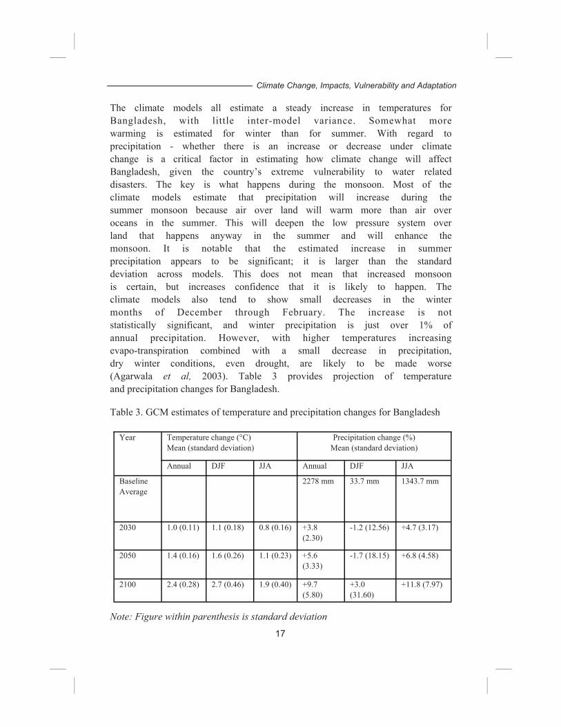
General Circulation Model used by the US Climate Change Study team for Bangladesh reported that the average increase in temperature would be 1.3°C and 2.6°C for the years 2030 and 2070, respectively. It was found that there would be a seasonal variation in changed temperature: 1.4°C change in the winter and 0.7°C in the monsoon months in 2030. For 2070 the variation would be 2.1°C and 1.7°C for winter and monsoon, respectively. For precipitation it was found that the winter precipitation would decrease at a negligible rate in 2030, while in 2075 there would not be any appreciable rainfall in winter. On the other hand, monsoon precipitation would increase at a rate of 12 per cent and 27 per cent for the two projection years, respectively (Ahmed and Alam, 1999). It was found that there would be excessive rainfall in the monsoon causing flooding and very little to no rainfall in the winter forcing drought. It was also found that there would be drastic changes in evaporation in both winter and monsoon seasons in the projection for year 2075. It was inferred from the GCM output that moderate changes regarding climate parameters would take place by 2030, while severe changes would occur by 2075 (Ahmed and Alam, 1999). The results also reveal a trend of a general increasing temperature. In 2030, the increase is much pronounced in winter months, although the maximum change is observed for post-winter months, i.e., April, May and June. However, in 2075, the increase in temperature during April and May is much higher; about 4.0OC (Ahmed and Alam, 1999). 2.2 Recent Climate Projection OECD has recently carried out 17 General Circulation Models for Bangladesh in order to assess changes in average temperature and precipitation using a new version of MAGICC/SCENGEN (software that allow users to investigate future climate change and its uncertainties at the global-mean and regional levels). It has selected 11 out of the 17 models which best simulate current climate over Bangladesh. The models were run with the Intergovernmental Panel on Climate Change (IPCC) B2 SRES scenario (Nakicenovic and Swart, 2000).
16
Climate Change, Impacts, Vulnerability and Adaptation
The climate models all estimate a steady increase in temperatures for Bangladesh, with little inter-model variance. Somewhat more warming is estimated for winter than for summer. With regard to precipitation - whether there is an increase or decrease under climate change is a critical factor in estimating how climate change will affect Bangladesh, given the country’s extreme vulnerability to water related disasters. The key is what happens during the monsoon. Most of the climate models estimate that precipitation will increase during the summer monsoon because air over land will warm more than air over oceans in the summer. This will deepen the low pressure system over land that happens anyway in the summer and will enhance the monsoon. It is notable that the estimated increase in summer precipitation appears to be significant; it is larger than the standard deviation across models. This does not mean that increased monsoon is certain, but increases confidence that it is likely to happen. The climate models also tend to show small decreases in the winter months of December through February. The increase is not statistically significant, and winter precipitation is just over 1% of annual precipitation. However, with higher temperatures increasing evapo-transpiration combined with a small decrease in precipitation, dry winter conditions, even drought, are likely to be made worse (Agarwala et al, 2003). Table 3 provides projection of temperature and precipitation changes for Bangladesh. Table 3. GCM estimates of temperature and precipitation changes for Bangladesh
Note: Figure within parenthesis is standard deviation
Year Temperature change (°C) Mean (standard deviation)
Precipitation change (%) Mean (standard deviation)
Annual DJF JJA Annual DJF JJA
Baseline Average
2278 mm
33.7 mm 1343.7 mm
2030 1.0 (0.11) 1.1 (0.18) 0.8 (0.16) +3.8 (2.30)
-1.2 (12.56) +4.7 (3.17)
2050 1.4 (0.16) 1.6 (0.26) 1.1 (0.23) +5.6 (3.33)
-1.7 (18.15) +6.8 (4.58)
2100 2.4 (0.28) 2.7 (0.46) 1.9 (0.40) +9.7 (5.80)
+3.0 (31.60)
+11.8 (7.97)
17
Climate Change, Impacts, Vulnerability and Adaptation
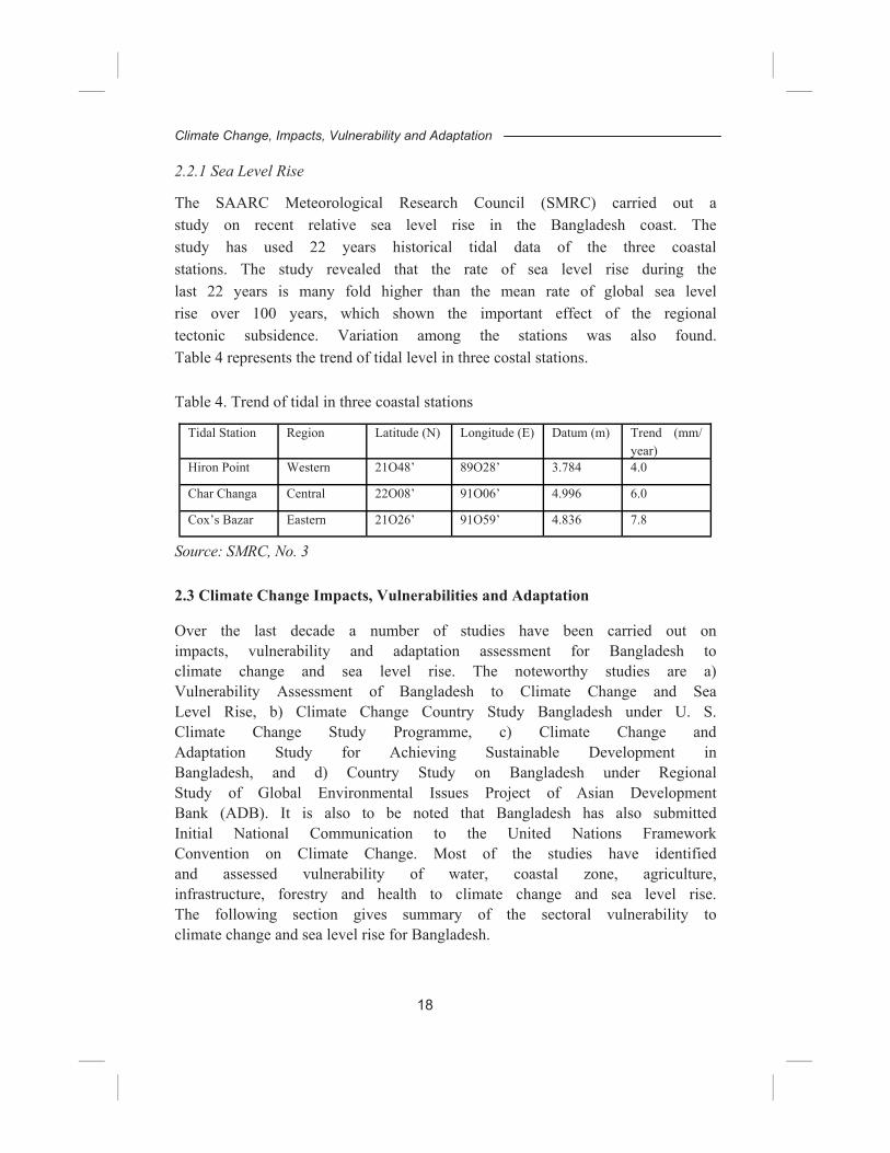
2.2.1 Sea Level Rise The SAARC Meteorological Research Council (SMRC) carried out a study on recent relative sea level rise in the Bangladesh coast. The study has used 22 years historical tidal data of the three coastal stations. The study revealed that the rate of sea level rise during the last 22 years is many fold higher than the mean rate of global sea level rise over 100 years, which shown the important effect of the regional tectonic subsidence. Variation among the stations was also found. Table 4 represents the trend of tidal level in three costal stations. Table 4. Trend of tidal in three coastal stations
Source: SMRC, No. 3 2.3 Climate Change Impacts, Vulnerabilities and Adaptation Over the last decade a number of studies have been carried out on impacts, vulnerability and adaptation assessment for Bangladesh to climate change and sea level rise. The noteworthy studies are a) Vulnerability Assessment of Bangladesh to Climate Change and Sea Level Rise, b) Climate Change Country Study Bangladesh under U. S. Climate Change Study Programme, c) Climate Change and Adaptation Study for Achieving Sustainable Development in Bangladesh, and d) Country Study on Bangladesh under Regional Study of Global Environmental Issues Project of Asian Development Bank (ADB). It is also to be noted that Bangladesh has also submitted Initial National Communication to the United Nations Framework Convention on Climate Change. Most of the studies have identified and assessed vulnerability of water, coastal zone, agriculture, infrastructure, forestry and health to climate change and sea level rise. The following section gives summary of the sectoral vulnerability to climate change and sea level rise for Bangladesh.
Tidal Station Region Latitude (N) Longitude (E) Datum (m) Trend (mm/year)
Hiron Point Western 21O48’ 89O28’ 3.784 4.0 Char Changa Central 22O08’ 91O06’ 4.996 6.0 Cox’s Bazar Eastern 21O26’ 91O59’ 4.836 7.8
18
Climate Change, Impacts, Vulnerability and Adaptation
2.3.1 Water Resources Water related impacts due to climate change and sea level rise are likely to be some of the most critical issues for Bangladesh, especially in relation to coastal and riverine flooding, but also in relation to the enhanced possibility of winter (dry season) drought in certain areas. The effects of increased flooding resulting from climate change will be the greatest problem faced by Bangladesh as both coastal (from sea and river water), and inland flooding (river/rain water) are expected to increase. In addition, changes of the riverbed due to sedimentation and changes in morphological processes due to seasonal variation of water level and flow are also critical for Bangladesh. Sedimentation and River Bed Rise One study suggested that changes in river water levels might cause changes in bed levels as the sediment carrying capacity of the rivers are affected. Decreased water level gradients due to higher downstream water levels at sea result in lower flow velocities and consequ en t ly cause sed i men ta t ion o f t he r i ve rb ed . The morphologically highly dynamic rivers in Bangladesh are expected to adapt to such changes in water levels in a period of time, which falls within the considered time horizon of 100 years. These changes in bed levels in turn will cause additional changes in river levels, which effect will propagate the impact of sea level rise in upstream direction. The first assessments of this effect in the study for the Jamuna Bridge showed the importance of this feed back mechanism (Rendel et al., 1990). It is found that at the bifurcations of the Jamuna river with its distributaries Dhaleswari river and Old Brahmaputra river, the bed level will rise 0.08, 0.12 and 0.41 m at the mouth of the Dhaleswari river and 0.05, 0.08 and 0.27 m at the mouth of the Old Brahmaputra river for the years 2015, 2025 and 2095 respectively (BCAS/RA/Approtech, 1994). This will probably result in a considerable increase in the discharges in the distributaries and a small decrease of the discharges in the Jamuna and Padma rivers. The discharge distribution at the tributaries of the Ganges and the Padma rivers (Gorai and Arial Kahn rivers) will change also due to the considered sedimentation. These changes might be of important consequences for the course of the main river channels in Bangladesh.
19
Climate Change, Impacts, Vulnerability and Adaptation
Change of Land Type Bangladesh Climate Change Country Study assessed vulnerability of water resources considering changes in flooding conditions due to a combination of increased discharge of river water during monsoon period and sea level rise for the two projection years, 2030 and 2075. It found that 8 per cent and 1 per cent (i.e. 3612 sq. km and 396 sq. km) of existing F0 and F1 land would become extremely vulnerable, respectively. Analysis also showed that 54 per cent (i.e. 17672 sq. km) of F1 land would become moderately vulnerable and 36 per cent of existing F0 and 32 per cent of existing F2 land would become slightly vulnerable in 2030. Moreover, 14 per cent of F1 land, 16 per cent of F2 land and 15 per cent of F3F4 land would virtually become F0 land due to the fact that embankment would make certain area flood free. Considering all types of changes from one class to the others, the country will lose 24 per cent (10726 sq. km) of F0 land and 19 per cent (i.e. 6263 sq. km) of F1 land. On the other hand 13601 sq. km land will be added to the existing F2 land (Alam, et al., 1999). Analyses of changes in inundation levels for the year 2075 suggested that substantial changes would occur both in a negative and positive sense. It is found that 16 per cent (i.e. 7267 sq. km) of existing F0 and 7 per cent (i.e. 2354 sq. km) of existing F1 land would become extremely vulnerable. About 54 per cent (i.e. 17585 sq. km) of existing F1 land would become moderately vulnerable and 36 per cent (i.e. 16203 Sq. Km.) of existing F0 land would become slightly vulnerable by the year 2075. In addition, 25 per cent of existing F1, 30 per cent of existing F2 and 22 per cent of existing F3F4 land would virtually become F0 land due to the fact that embankment would make certain area flood free. Considering all types of changes from one class to the others, it is found that 16 per cent (7764 sq. km) of F0 land and 34 per cent (i.e. 1194 sq. km) of F1 land would be submerged in monsoon. On the other hand 12345 sq. km land will be added with the existing F2 land (Alam, et al., 1999). From the above analysis extreme impact is found for F0 land followed by F1 land in the year 2075 where embankment played an important role in restricting the extent of flood affected areas. On the other hand, extreme impact is found for F0 land followed by F1 land in 2030 where only the north-central region was considered to be under the protection of embankment. A combination of development
20
Climate Change, Impacts, Vulnerability and Adaptation
and climate change scenarios revealed that the Lower Ganges and the Surma floodplain would become more vulnerable compared to the rest of the study area. On the other hand, the north-central region would become flood free due to embanking the major rivers (Alam, et al., 1999). 2.3.2 Coastal Zone
It is reported by several studies that the coastal zone vulnerability would be acute due to the combined effects of climate change, sea level rise, subsidence, and changes of upstream river discharge, cyclone and coastal embankments. There are four key issues of primary physical effects i.e. salt-water intrusion; drainage congestion; extreme events; and coastal morphology have been identified as key vulnerability of the coastal area of Bangladesh (WB, 2000). A relationship between agents of change and primary physical effects in the coastal zone of Bangladesh is given in table 5.
• The effect of saline water intrusion in the estuaries and into the groundwater would be stimulated by low river flow, sea level rise and subsidence. Pressure of the growing population and economic development wil l further reduce fresh water availability in future. The adverse effects of salt-water intrusion will be significant on coastal agriculture and the availability of fresh water for public and industrial water supply.
• The combined effect of higher sea water levels, subsidence, siltation of estuary branches, higher riverbed levels and reduced sedimentation in flood-protected areas impedes drainage and will gradually increase water logging problems. This effect will be particularly strong in the coastal zone. The problem will be aggravated by the continuous development of infrastructure (e.g. roads) reducing further the limited natural drainage capacity in the delta. Increased periods of inundation may hamper agricultural productivity, and will also threaten human health by increasing the potential for water borne disease.
• Disturbance of coastal morphological processes would become a significant problem under warmer climate change regime. Bangladesh’ coastal morphological processes are extremely dynamic, partly because of the tidal and seasonal variations in river flows and run off. Climate change is expected to increase these variations, with two main (related) processes involved:
21
Climate Change, Impacts, Vulnerability and Adaptation
• Increased bank erosion and bed level changes of coastal rivers and estuaries. There will be a substantial increase of morphological activity with increased river flow, implying that riverbank erosion might substantially increase in the future.
• Disturbance of the balance between river sediment transport and deposition in rivers, flood plains and coastal areas. Disturbance of the sedimentation balance will result in higher bed levels of rivers and coastal areas, which in turn will lead to higher water levels.
• Increased intensity of extreme events. The coastal area of Bangladesh and the Bay of Bengal are located at the tip of northern Indian Ocean, which has the shape of an inverted funnel. The area is frequently hit by severe cyclonic storms, generating long wave tidal surges which are aggravated because the Bay itself is quite shallow. Cyclones and Storm Surges are expected to become more intense with climate change. Though the country is relatively well equipped in one aspect of disaster management, increased intensity of the disasters implies major constraints to the country’s social and economic development. Private sector investment in this area is likely to be affected by the risks of cyclones and increased flooding.
Table 5. Relation between agents of change and primary physical effects in the coastal zone of Bangladesh.
Climate Change, Impacts, Vulnerability and Adaptation
2.3.3 Crop Agriculture and Food Security Various studies indicate that a rise of 1 to 20C in combination with lower radiation causes sterility in rice spikelets. High temperature was found to reduce yields of HYVs of aus, aman and boro rice in all study locations and in all seasons and it was particularly evident at a 40C rise. Climate changes, especially in temperature, humidity and radiation, have great effects on the incidence of insect pests, diseases and microorganisms. A change of 10C changes the virulence of some races of rust infecting wheat.
The production of crop in Bangladesh is constrained by too much water during the wet season and too little during the dry season. Presently total irrigated area is 4.4 million ha which is more than 50 percent of the potentially irrigable area of 7.12 million ha cultivated area. This area is being irrigated through surface and ground water resource. Irrigation coverage through Shallow tubewells (STWs) during dry period is growing very fast following the recent policy of privatisation. As a result, the groundwater table in Bangladesh is declining at an alarming rate causing STWs non-operating in many parts of the country during dry period. Lack of surface water during the dry season limits the function of Low Lift Pumps.
The simulation study conducted under the climate change country study assessed the vulnerability of foodgrain production due to climate change in Bangladesh. Two general circulation models were used for development of climate scenarios. The experiments considered impact on three high yielding rice varieties and a high yielding wheat variety. Sensitivity to changes in temperature, moisture regime and carbon dioxide fertilization was analysed against the baseline climate condition.
The GFDL model predicted about 17 per cent decline in overall rice production and as high as 61 per cent decline in wheat production compared to the baseline situation. The highest impact would be on wheat followed by Aus variety. This translates reduction of 4.42 million tons of rice at the present level (2002) of production. Mostly, the Aus rice seems to be vulnerable. Other model, Canadian Climate Change Model (CCCM) predicted a significant but reduced shortfall in food-grain production.
23
Climate Change, Impacts, Vulnerability and Adaptation
It was noticed that temperature increase of 4oC would have severe impact on food-grain production, especially for wheat production. On the other hand, carbon-dioxide fertilization would facilitate food- grain production. A rise in temperature cause significant decrease in production, some 28 and 68 per cent for rice and wheat, respectively. Moreover, doubling of atmospheric concentration of CO2 in combination with a similar rise in temperature would result into an overall 20 per cent rise in rice production and 31 per cent decline in wheat production. It was found that Boro rice would enjoy good harvest under severe climate change scenario. The apparent increase in yield of Boro and other crops might be constrained by moisture stress. A 60 per cent moisture stress on top of other effects might cause as high as 32 per cent decline in Boro yield, instead of having an overall 20 per cent net increase. It is feared that moisture stress would be more intense during the dry season, which might force the Bangladeshi farmers to reduce the area for Boro cultivation. Shortfall in foodgrain production would severely threaten food security of the poverty-ridden country. Under a severe climate change scenario the potential shortfall in rice production could exceed 30 per cent from the trend, while that for wheat and potato could be as high as 50 and 70 per cent, respectively (Karim, 1996). Under a moderate climate change scenario the crop loss due to salinity intrusion could be about 0.2 Mt (Habibullah et al., 1998). Considering the loss of production due to such effects, one may find these to have relatively higher intensity than the floods. However, the loss incurred in other sectors could be much higher in case of floods. The effect of low-flow on agricultural vulnerability is considered to be much less intense compared to other effects. The ultimate impacts of loss of food grain production would increase import of food spending hard currency. 2.3.4 Forestry and biodiversity Bangladesh is endowed with a number of natural forest ecosystems including inland Sal forest, dipterocarp forest, savanna, bamboo bushes in the hilly regions and freshwater swamp forests. It also has littoral mangrove ecosystems. Bangladesh Climate Change Country Study has made an attempt to qualitatively analyse the impact of climate change on forest resources of Bangladesh.
24
Climate Change, Impacts, Vulnerability and Adaptation
It is found that increased rainfall during the monsoon would cause increased runoff in forest floor instead of infiltration into the soil. As a result there would be enhanced soil erosion from the forest floor. The erosion problem would be more pronounced in poorly dense hill forest areas. Prolonged floods would severely affect growth of many timber species, while it would cause high incidence of mortality for Artocarpus species. In contrast, enhanced evapotranspiration in winter would cause increased moisture stress, especially in the Barind and Madhupur Tract areas, affecting the Sal forest ecosystem. The tea plantations in the north-east would also suffer due to moisture stress. It was found that the Sundarbans mangrove forest would be the worst victim of climate change. Due to a combination of high evapotranspiration and low-flow in winter, the salinity of the soil would increase. As a result the growth of freshwater loving species would be severely affected. Eventually the species offering dense canopy cover would be replaced by non-woody shrubs and bushes, while the overall forest productivity would decline significantly. The degradation of forest quality might cause a gradual depletion of rich diversity of the forest flora and fauna of the Sundarbans ecosystem (Ahmad et al., 1999).
2.3.5 Human health
The combination of higher temperatures and potential increases in summer precipitation could create the conditions for greater intensity or spread of many infectious diseases. However, risk in the human health sector is low relative to climate change induced risks in other sectors (such as water resources) mainly because of the higher uncertainty about many of the health outcomes. Increased risk to human health from increased flooding and cyclones seems most likely. Changes in infectious disease are less certain. The causes of outbreaks of infectious disease are quite complex and often do not have a simple relationship with increasing temperature or change in precipitation. It is not clear if the magnitude of the change in health risks resulting from climate change will be significant compared to current risks. It is also not clear if increased health risk will be apparent in the next few decades. However, in general climate change is expected to present increased risks to human health in Bangladesh, especially in light of the poor state of the country’s public health infrastructure. Life expectancy is only 61 years, and 61% of children are malnourished (World Bank, 2002). Perhaps more illustrative of
25
Climate Change, Impacts, Vulnerability and Adaptation
this point, though, is the US$12 per person per year that the Bangladeshi government expends on health, well below the US$21 spent in low income countries in general (World Bank, 2002). 2.4 Vulnerability of households
The overall impacts of climate change in Bangladesh will have far reaching consequences, not only on the physical features, but also on the socio-economic aspects of the country. The agricultural sector is the major provider of employment and there are indications that it will remain so in the near future. Loss of both agricultural land and production will adversely affect livelihood of the rural poor. Loss of income and unemployment could jeopardize the dream of reducing the number of people that lives below the poverty line by 50 per cent as stated in the poverty reduction strategy paper and to meet Millennium Development Goals. As it happened in the cases of earlier disasters, poverty driven rural population will tend to migrate to the urban centres. Large scale inter-community migration is likely in increase social unrest.
Losses of livelihood of a large population throughout the country will not only increase the risk of large-scale migration, but also lead to increased competition for the remaining natural resources. The end result of these will be manifested by increased exploitation of the natural resource base and gradual degradation of it - both having a negative impact on sustainable resource management. Moreover, taking control over common property regimes will lead to an escalation of social conflicts, an eventuality when acute inequity prevails in a society.
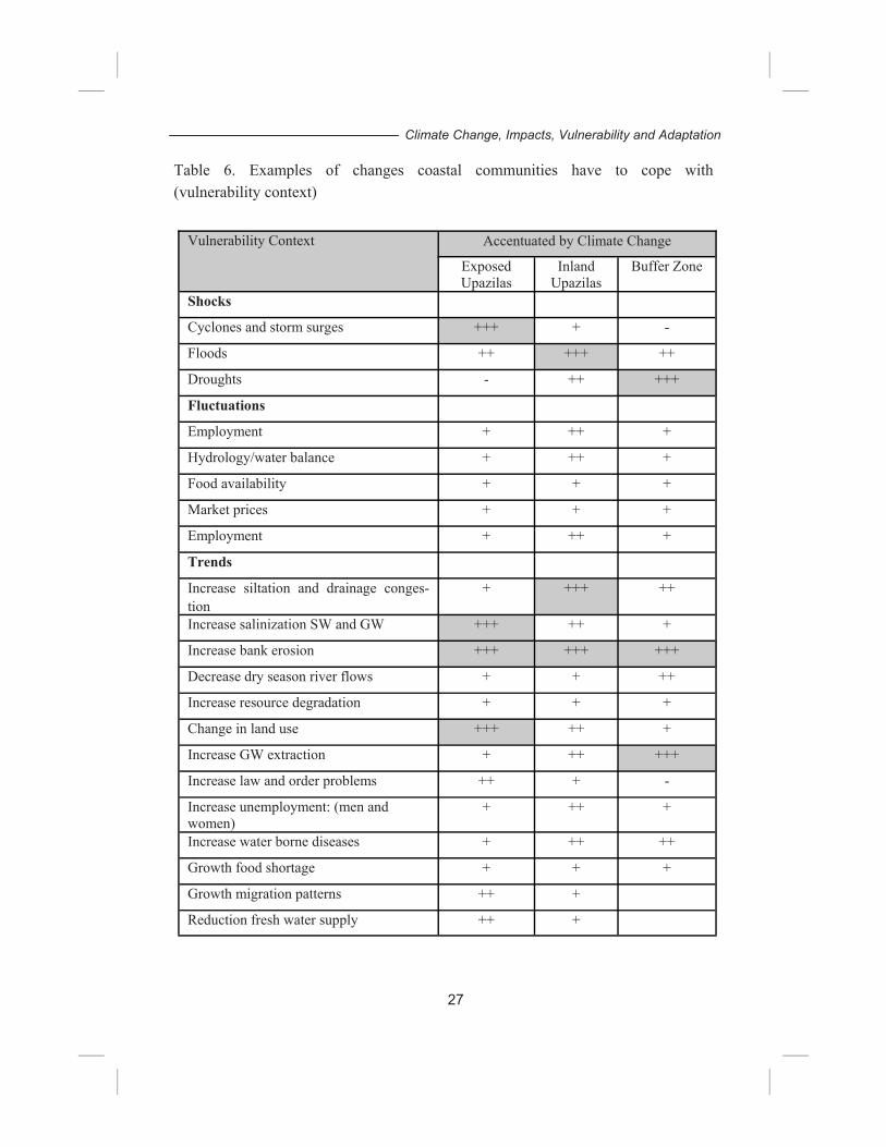
Vulnerability of households relates to their resilience against: shocks (disastrous unexpected happenings, such as an earthquake or death of an income generating household member); fluctuations (mainly referring to seasonal variations in e.g., hydrology and food); and trends (long term slow developments such as soil and water quality deterioration). Vulnerability to climate change means in fact that climate change adversely affects the capability of people to cope with such other “normal” vulnerabilities as: food and income security and safety of properties. Therefore, the entire situation is very complex. For example, a complex situation of vulnerability of a coastal community is presented in table 6 with different level of exposure.
26
Climate Change, Impacts, Vulnerability and Adaptation
27
Climate Change, Impacts, Vulnerability and Adaptation
Table 6. Examples of changes coastal communities have to cope with (vulnerability context)
Vulnerability Context Accentuated by Climate Change
Exposed Upazilas
Inland Upazilas
Buffer Zone
Shocks
Cyclones and storm surges +++ + -
Floods ++ +++ ++
Droughts - ++ +++
Fluctuations
Employment + ++ +
Hydrology/water balance + ++ +
Food availability + + +
Market prices + + +
Employment + ++ +
Trends
Increase siltation and drainage conges-tion
+ +++ ++
Increase salinization SW and GW +++ ++ +
Increase bank erosion +++ +++ +++
Decrease dry season river flows + + ++
Increase resource degradation + + +
Change in land use +++ ++ +
Increase GW extraction + ++ +++
Increase law and order problems ++ + -
Increase unemployment: (men and women)
+ ++ +
Increase water borne diseases + ++ ++
Growth food shortage + + +
Growth migration patterns ++ +
Reduction fresh water supply ++ +
2.5 Adaptation Options
It is revealed from the several climate change studies and assessment reports that water resources are of greatest concern for Bangladesh because flooding is already an important issue for the country. Increased flooding would without doubt be significant. Since small changes in runoff can substantially increase flooding, it is expected that increased flooding will be noticeable in the next few decades. The combination of increased glacial melt in upper riparian countries and increased monsoon intensity makes increased flooding likely.
Bangladesh’s coastal resources are also very vulnerable because the country exists mainly in a delta with most of its population and resources at low elevations and the Sundarbans are threatened by sea level rise. The Sundarbans are important because they are the largest mangrove system in the world and sea level rise could destroy or fundamentally change the entire ecosystem. Sea level is likely to rise; indeed it is more certain than increased flooding.
A number of studies estimate an increase in yields with small amounts of warming, but decreased yields with larger levels of warming. With the mixture of beneficial and initially adverse impacts, the agricultural sector is also a key concern area for Bangladesh as a large number of people are depend directly or indirectly on this sector.
Several studies have identified adaptation measures to reduce adverse impacts of climate stimuli including variability and extreme events (World Bank, 2000, (BCAS/RA/Approtech, 1994, Agrawal et al., 2003). Key adaptation measures identified for the above key three sectors have been grouped under three broad categories of adaptation measures.
2.5.1 Physical Measures
The physical adaptation measures include engineering projects to reduce vulnerability, particularly to reduce flood impacts and to improve drainage conditions for addressing adverse impacts related to floods, salinity, and drought. These are typically more expensive measures that address a specific problem, but they can also produce multiple uses and benefits. The World Bank study focused on the identified major physical impacts: freshwater flow, drainage congestion; salt water intrusion; morphologic dynamics; and natural disasters. The identified physical measures are as follows.
26
Climate Change, Impacts, Vulnerability and Adaptation
Flooding: full flood projection and controlled flooding have been identified to address the flooding problem in Bangladesh. Full flood protection is widely practised in Bangladesh. Effectiveness and feasibility is high but sustainability is low because of operation and maintenance requirements and long term accumulating effects of flood storage reduction and prevention of sedimentation in the f l o o d p l a i n . C o n t r o l l e d f l o o d i n g i n c o m b i n a t i o n w i t h compartmentalization is one form of adaptation which has been practiced under the Flood Action Plan project. The advantage of this option is less exposure to erosion while the sedimentation in the floodplain enhanced. The major disadvantage is the limited land use allowed in the floodplain and the advanced arrangements needed for proper management.
Increasing surface water availability: increasing surface water flow has been identified to address drought and salinity problems in the dry season. Augmentation of river water by increasing local storage capacity of surface or groundwater for irrigation and addressing salinity problem for Sundarbans is necessary. Desalinization plants and equipment for addressing the drinking water problem related to salinity has also been identified. The Gorai River Restoration Project is an example of increasing surface water flows through deviating water from the Ganges River towards the southwest. Effectiveness of such measures is high, but feasibility is low because of high costs. The possibilities for increased local storage of surface and groundwater in the area itself are low as well. Desalinization plants and equipment are too expensive as possible adaptation measure.
Reduce Drainage Congestion: reduce drainage congestion requires mainly two steps: (i) bringing water from the land into the main drainage system; and (ii) draining water to the sea. At present, step i is done under gravity, mostly through regulators which open during low water flow in the river and low tides in the coastal area. Increasing the drainage capacity of existing infrastructure seems a feasible and effective way to reduce drainage congestion where culverts, bridges, regulators etc hamper drainage. When higher water levels impede this process, pumping remains the ultimate solution. Step ii requires a well-maintained drainage network. Continuous dredging is an option, which can be reduced by the construction of regulators and/or tidal basins. Tidal basins stand out as a preferred option from an environmental and maintenance perspective (since
27
Climate Change, Impacts, Vulnerability and Adaptation
tidal basins would substantially reduce the maintenance dredging and bring sediments to the beel areas). The tidal basin experience in Khulna-Jessore Drainage Rehabilitation Project proves that this is a feasible approach.
Construction of new infrastructure: such as cyclone shelters and /or coastal embankments and landfills, modification of existing infrastructure. Construction of coastal embankments and landfills should focus on special areas such as urban centers and concentrations of industrial activities. Design of new high value infrastructure (roads, sluices and embankments) could be altered with consideration of climate change. New and existing mangrove belts (as mentioned earlier) appear to be effective in protecting against coastal storms, and in facilitating sedimentation (Haider, 1992). Such activities in Bangladesh needs to be streamlined by ensuring peoples’ participation in maintaining and benefit sharing.
Mangrove and Cross Dams: adaptation measures identified to address morphological dynamics include mangrove greenbelts, cross dams and/or river training works. Mangrove greenbelts in the foreshore areas and along the coastal embankments, and cross dams at the same time enhance accretion. River training works, e.g., through bank protection or strong holds are confined to the estuarine river branches. All these measures are effective. The main challenges for cross dams and river training works are in feasibility, in particular as it requires long-term maintenance. The high effectiveness and feasibility of mangrove greenbelts are well acknowledged.
2.5.2 Soft Measures
Effective Early Warning System: an early warning system for cyclonic disasters and floods in Bangladesh is a viable adaptation strategy for reducing damage. The present early warning system and responses for cyclone disasters is effective while the warning system and responses to floods needs improvement. Continuous monitoring of the formation of cyclones in the Bay of Bengal involving satellite- based technology; monitoring of the gradual development and track of imminent cyclone; issuance of cyclone warning well ahead of time for the people to take precautionary measures; evacuation from homesteads and relocation in multi-purpose cyclone shelters and concrete buildings ─ all may be considered as highly useful and
30
Climate Change, Impacts, Vulnerability and Adaptation
proven adaptation strategies. Already such measures have allowed thousands of coastal people to successfully avoid loss of lives during two high intensity cyclonic events: one occurring in 1994 and the other in 1997 (Ahmed, 2000).
Operation and Maintenance: operation and maintenance of sluices and other regulators, groundwater management, land use practice, extension services, and water saving techniques are identified as win- win option options to address present needs and leading to higher degree of future success. Improving maintenance and operation of sluices and other regulators to hold water in areas that are under increased stress or establishing effective groundwater management both score high on effectiveness but low on feasibility. Land use practice can be influenced by incentives to change agricultural practices so that agricultural demand for fresh water goes down.
2.5.3 Institutional Issues
The Ministry Environment and Forests (MoEF) is the focal point for the United Nations Framework Convention on Climate Change (UNFCCC) and coordinate climate related activities in the country. Recently the government has established the Climate Change Cell to address several issues including adaptation to climate change. A few cross-cutting capacity building needs identified for adaptation options include:
• Lack of public awareness—addressing this may be the most effective way to reduce vulnerability to climate change and increase the effectiveness of adaptation options.
• Need for inter-departmental coordination—building rural i n f r a s t r u c t u r e , p r o p e r o p e r a t i o n a n d m a i n t e n a n c e arrangements, design criteria for drainage capacity of infrastructure, and establishment & support of local water management. Dialogue should also be maintained with c o m m u n i t y - b a s e d o r g a n i s a t i o n s w o r k i n g o n r u r a l development and sustainable livelihoods.
• Need for regional collaboration—this is necessary for the trans- boundary water issue taking into account the relevant sectors vulnerable to water with spatial and temporal context. Information sharing on watershed levels are found to be
31
Climate Change, Impacts, Vulnerability and Adaptation
• effective and essential. Furthermore, comprehensive river basin or lake/reservoir management to address both climate change and future growth are needed.
• Collaborative Research: the present collaborative relationship of the National Agricultural Research System (NARS) with international and regional research institutes/centres must be strengthened, particularly in germplasm exchange and training of scientists. This collaborative programme also needs to be expanded between the NARS institutes and the private sector including the NGOs and the farmers. The private sector and the NGOs play a great role in the refinement of NARS technologies, developing farmers’ group-oriented technologies and in initiating research, especially in crops having export potential. The private sector and the NGOs can as well be involved in developing hybrid technology in rice, maize, vegetables and sunflower in particular. Without such collaboration, it will be extremely difficult to meet challenges of increasing and sustaining crop production in the future years.
• Training: agricultural research is at present constrained by the acute shortage of trained and skilled scientists. The quality of research needs to be improved by gradually implementing the present training programmes (degree, non-degree, short-term, etc) earmarked for the scientists and initiating and materializing new training programmes in appropriate f ie lds ident i f ied by different NARS institutes.
• Need for international partnerships, capacity building, and assistance—International assistance will be required not only for funding, but also in terms of technical expertise and human resource development.
32
Climate Change, Impacts, Vulnerability and Adaptation
Mainstreaming Adaptation to Climate Change
3 Mainstreaming Adaptation to Climate Change
Recognition, by both national and international agencies, of the adverse impacts of climate change and extreme events on future development and an incorporation of this awareness in policy and strategy documents, can be seen as the beginning of mainstreaming adaptation to climate change. The next step is a shift from policy to action which needs integration, not easy task, with existing development programmes and activities. The shift from policy to action needs participation of and cooperation from different stakeholders (government policy makers, implementing agencies, development partners, private sector, and communities). The following section provide a brief review of the present status in terms of recognition of adverse impacts of climate change in policies, strategies and actions being implemented to address climate change, variability and extreme events. It also reviews the status and process regarding the preparing of the National Adaptation Programme of Action in Bangladesh, as urgent and immediate actions need to be incorporated in the context of development and livelihoods. 3.1 Present Policies and Activities 3.1.1 Climate Change Concerns in MEAs, Macro Policies and Plans
Bangladesh is a party to various international environmental conventions, including the UNFCCC, UNCCD, UNCBD and the RAMSAR Convention on Wetlands. Bangladesh submitted its first National Communications to the UNFCCC in late 2002. Bangladesh has also submitted two reports (in 2001 and 2002) to the UNCCD which do not discuss climate change (Agarwala et al., 2003).
With regard to UNCBD, Bangladesh has not yet submitted a National Biodiversity strategy and action plan (NBSAP). A report on alien species does not touch upon climate related issues. Bangladesh has also produced a National Planning Tool for the implementation of the Ramsar Convention on wetlands that draws linkages between Ramsar and biodiversity issues, but not with climate change concerns in the context of coastal wetlands. Similarly, the country’s documentation for the World Summit on Sustainable Development only discusses climate change as a stand-alone air quality issue, rather than a cross- cutting concern affecting many aspects of sustainable development.
33
Mainstreaming Adaptation to Climate Change
Bangladesh’s I-PRSP recognizes the direct links between poverty and vulnerability to natural hazards: “Given the risk and vulnerability to natural hazards that are likely to continue as a serious threat to national development efforts, macro level policies for disaster risk reduction, mitigation and management must be adopted in view of alleviating disaster-induced poverty”. It notes that the incidence of disasters is likely to increase rather than decrease, particularly due to global climate change. The I-PRSP proposes a comprehensive and anticipatory approach to reduce Bangladesh’s vulnerability: “… to reduce vulnerability to natural, environmental and human induced hazards through community empowerment and integration of sustainable risk management initiatives in all development programs and projects. This vision would be achieved by a multi-hazard and multi-agency approach to address vulnerability, risk assessment and mitigation that include prevention, preparedness, response and recovery. The vision considers a transition from a response and relief focus to vulnerability and risk reduction approach in disaster management” (Agarwala et al., 2003). In contrast to the strong emphasis on climate change in the discussion of Bangladesh’s disaster trends, climate change is not mentioned in the context of planning vulnerability reduction measures (except for a proposal for further research on impacts). Outside of the section on natural hazards, the PRSP does not contain any references to climate change. Nevertheless, many of the proposed measures to reduce current vulnerability will also contribute to improved adaptation to climate change. For instance, the medium-term agenda for water management includes many items that will reduce climate vulnerability, including the formulation of national policies for water management, forestry, agriculture, fisheries and environment, but also regional and local level activities, ranging from engineering solutions and afforestation to community-level natural resources management arrangements. Some of these items would benefit from an explicit consideration of climate change. Similarly, in the context of agriculture policy, the PRSP proposes specific attention for improved agricultural technologies and practices in flood- and drought-prone areas, but does not mention climate change considerations, which would need to be taken into account in planning and implementation of such measures.
34
Mainstreaming Adaptation to Climate Change
Work is currently underway to develop the National Adaptation Plan of Action (NAPA) for Bangladesh, although it is too early to assess whether the NAPA will lead to a comprehensive national policy that is endorsed and implemented by the government. However, the NAPA preparation process has included most of the relevant sectors, agencies both from government and private sectors. Therefore it is expected that it will lead to mainstreaming adaptation to climate change at sectoral level development policies and plans.
3.1.2 Climate Concerns in Sectoral Policies, Programmes and Projects Bangladesh has put in place a number of sectoral policies and plans (particularly during the 1990s) that bear upon its ability to cope with current climate risks, and to some extent the additional risks posed by climate change. The National Water Policy (NWP) announced in 1999 is the first comprehensive look at short, medium and long-term perspectives for water resources in Bangladesh. The NWP was followed by the National Water Management Plan (NWMP) in 2001 that looks at implementation and investment responses to address the critical priorities identified in the NWP. NWMP was evaluated and approved by a Parliamentary Committee recently. Given the criticality of climate change impacts on water resources (see Section 4.1), it is noteworthy that NWP does not explicitly mention this issue. NWMP however recognizes climate change as one of the factors determining future water supply and demand. The summary section on agriculture and water management states that “in undertaking these works the potential impacts of climate change and sea level rise will be factored in”. In relation to the coastal zone, the draft NWMP states, “…sea level rise due to global warming continued sedimentation of the rivers and flood plains and subsidence of the Ganges basin are all factors that will affect sea levels with respect to land levels. Each is difficult to predict with certainty, as reflected in the breadth of estimates of net sea level rise of 4.5~23 cm in 2025 and 6.5~44 cm by 2050”. On coastal zones the NWMP further states “…the situation is further complicated by an observed trend of increased tidal amplitude associated with reduction of tidal flows due to empolderment in the South West Region. By 1995, the tidal range had increased to about 3.0 m from about 1.8 m in 1960.
35
Bangladesh’s National Environmental Management Action Plan (NEMAP), which was published in 1995, does not explicitly discuss climate change. NEMAP however does add a cautionary note on the environmental damages that may result from structural flood control measures – which might highlight some conflicts with structural adaptation responses (such as the construction of barrages) highlighted under the NWP and NWMP, and other environmental consequences such as migration and breeding of fish-stock. Similar to NEMAP, the National Land Use Policy (NLUP) does not make direct reference to climate change. NLUP however aims to bring 25% of the land under forest cover and highlights mangrove plantations in char lands, and coastal green belts more generally as a priority. It also advocates conservation of existing forest lands, including the Sundarbans. These priorities of NLUP are also echoed the National Forest Policy (NFoP) that was initially formulated in 1979 and revised in 1994 – although the goal of NFoP is to bring 20% (as opposed to 25% in NLUP) of the total land under forest cover. Forest conservation priorities in NFoP and NLUP could help reduce some of the other stresses on ecosystems such as the Sundarbans, thereby increasing their resilience to the impacts of climate change.
3.1.3 Climate Concerns in Donor Strategies and Activities
In 1996, the World Bank and Bangladesh Centre for Advanced Studies (BCAS) prepared ‘Bangladesh 2020: Long-run Perspective’ which raised the issue of climate change. It has stated that “although the impacts of global warming are still far from precisely predictable, the prospect is sufficiently likely and alarming to warrant precautionary action at the national as well as at the international level.” Particularly the potential economic impacts of sea-level rise (13% of GDP) gave rise to the conclusion that further work was needed. “The seriousness of the problem warrants strenuous research efforts to understand various aspects of the problem and devise remedies for future generations.” It advocated a dual response – international diplomacy in support of global mitigation, and national planning for adaptation.
The World Bank responded to this by sponsoring the Bangladesh Climate Change and Sustainable Development study (2000), which analyzed the possible impacts of climate change, identified physical and institutional adaptation options, and reviewed a number of
36
Mainstreaming Adaptation to Climate Change
development projects and the National Water Management Plan. Its main aim was to mainstream adaptation in the regular development strategies and operations in Bangladesh. Three years later (in 2003), it appears that the results have partly been embraced in some sectors (Huq, 2002, and Rahman and Alam, 2003). When provided with suitably presented information, sectoral policy makers, planners, and managers have indeed mainstreamed climate change into their regular work. For instance, recommendations of the World Bank study have been incorporated in coastal zone management programs and adopted in the preparation of (cyclone) disaster preparedness plans and a new 2 5-year water sector plan. In agriculture, the results were deemed relevant to research programs particularly for drought and saline tolerant rice varieties, but not for agricultural extension. Stakeholders in public health showed interest in the issue, although they did not see any short-term implications for their day-to-day decisions (Agarwala et al., 2003). Agarwala et al., 2003 has mentioned that similar pattern arises in most of the other donors’ strategies for Bangladesh. Ample attention is paid to the risk of natural hazards, and many efforts are made to reduce Bangladesh’s vulnerability to those risks, but climate change is not mentioned, or receives very little consideration. The European Commission has recently developed a climate change strategy for support to partner countries (European Commission 2003). The overall objective of this strategy is to assist partner countries in meeting challenges posed by climate change through mainstreaming climate concerns into EU development cooperation. The strategy consists of four strategic priorities: (i) raising the policy profile of climate change, (ii) support for adaptation, (iii) support for mitigation, and (iv) capacity development, which are translated into a proposed action plan. IFAD’s Country Strategic Opportunities Paper also neglects climate change as a risk factor, but provides an interesting perspective on vulnerability to natural hazards and development strategies in Bangladesh. The paper finds a disconnection between “micro success” and “macro stagnation”. It suggests that poverty reduction strategies in Bangladesh have been very successful in increasing resilience, demonstrated by impressive gains in the areas of food production, population control, health education, and in building up the institutional capacities of the poor. The way in which Bangladesh
37
Mainstreaming Adaptation to Climate Change
was able to manage the devastating 1998 floods is another example of this resilience, which is characterized by people’s own efforts as well as government initiatives in safety net provisioning and rural infrastructure development.
Another perspective on climate change risks in Bangladesh is provided in a BMZ study on climate change and conflict (Brauch, 2002). Its case study on Bangladesh showed that this country has already been a primary victim of extreme weather events (cyclones, floods and droughts) that forced people to migrate. The increase in environmental stress due to climate change may further raise the conflict potential and might eventually lead to international tensions and regional instability: “In Bangladesh the struggle for survival against the impacts of global environmental change has been real for decades. Without more intensive efforts to address the causes at their roots a major human catastrophe may be possible that will not only affect the neighboring states (India, Myanmar) but the OECD countries as well.” No attention to these trans-boundary risks however was reflected in any of the donor strategies. 3.1.4 Attention to Climate Risks in Selected Development Projects The World Bank report Bangladesh Climate Change and Sustainable Development (2000) includes a review of sixteen development activities (mainly by the ADB and the World Bank, and also by the Netherlands and DFID) in the light of adaptation to climate change. This review considered two aspects: vulnerability of the projects themselves, as well as opportunities to reduce Bangladesh’s vulnerability in a broader sense. The report’s main finding was that most of the activities reviewed do not consider climate change impacts or adaptation to such impacts. The OECD study (Agarwala et al., 2003) has reviewed 31 projects of sectors that are highly vulnerable, such as water management or coastal biodiversity. It revealed that many projects contribute directly or indirectly to a reduction in vulnerability, and most of them do take into account the natural hazards affecting Bangladesh. Only a few, such as the GEF/UNDP Coastal and Wetland Biodiversity Management at Cox's Bazar and Hakaluki Haor (2000- 2007), note the potential effect of sea level rise. UNDP’s Comprehensive Disaster Management Program (CDMP) lists climate change as a serious
38
Mainstreaming Adaptation to Climate Change
component of Bangladesh’s vulnerability to natural hazards, to be integrated in the program’s disaster risk reduction strategies. It is difficult to gauge the extent to which climate change considerations would have affected the design of the other projects.
Huq (2002) and Rahman and Alam (2003) have reported that several ongoing development projects, such as the World Bank’s coastal zone management project, and the GEF/ADB Biodiversity Conservation in the Sunderbans Reserve forest project, planned to incorporate considerations from the World Bank climate change study. However such developments, occurring during the project lifetime, are not reflected in the initial project documents.
One of the projects that were reviewed, the GEF/World Bank/DFID Aquatic Biodiversity Project, highlights the negative impacts of flood protection measures on inland open-water fisheries and biodiversity. Such findings re-emphasize the need to adopt cross-sectoral and comprehensive approaches to hazard risk management and sustainable development, particularly in the face of the increasing risks due to climate change.
Bangladesh has set a pioneer example in disaster management during the cyclones of 1991 and 1997. The role of the government and non- government organizations during the pre and post-disaster periods helped shrink the number of deaths and damage. The initiatives were appreciated and recognized worldwide. As a part of structural mitigation measures the GoB with its own and external resources has so far constructed 1,841 cyclone shelters, and 200 flood shelters for evacuation of people threatened by cyclone or flood. In addition, coastal embankments about 3,931 km long have been made to protect coastal land from inundation by tidal waves and storm surges, and drainage channels of total length 4,774 km have been constructed.
The Government of Bangladesh has undertaken a Green Belt Project in the coastal areas. This is a participatory reforestation program aimed at reducing the adverse impacts of natural disasters, particularly cyclones and storm surges in the coastal regions.
National Adaptation Programme of Action (NAPA) The Ministry of Environment and Forest is the government agency that is responsible for the planning and execution of all activities on
39
Mainstreaming Adaptation to Climate Change
environmental protection and management. It is both the GEF and UNFCCC National Focal Point and thus executes NAPA. The preparation of the National Adaptation Programme of Action (NAPA) is the first official initiative for mainstreaming adaptation to national policies and actions for addressing adverse impacts of climate change and reduce vulnerability to climate stimuli including extreme events. It will be a document of project portfolio giving emphasis on the most urgent and immediate needs of the country and the implementation of these projects and activities will reduce both the vulnerability and the cost that otherwise will occur if addressed later. The international formulation mission of the United Nations Development Programme (UNDP) prepared the National Adaptation Programme of Action (NAPA) proposal for Bangladesh. The proposal was prepared in consultation with the Secretary, Ministry of Environment and Forest; Secretary of Planning Commission; Director General of Department of Environment; concerned persons of the Planning Commission and other relevant Government agencies, civil society bodies and donors such as DFID and CIDA. The draft document was further refined at the stakeholders meetings organized by the Ministry of Environment and Forest. The project proposal was sent to GEF for fund approval with concurrence from the concerned agencies and accordingly GEF Secretariat has approved the proposal in April 2003. 3.2.1 Priority Sectors The formulation of the Bangladesh Programme of Action for Adaptation to Climate Change has identified five sectoral working groups: a) agriculture, fisheries and livestock, b) forestry, biodiversity and landuse, c) water, coastal area, natural disasters and health, d) industry and infrastructure, and two cross-cutting working group on e) livelihood, gender, local governance and food security, f) policy and institutions. The government has already engaged six organizations for coordinating six the working groups.
40
Mainstreaming Adaptation to Climate Change
3.2.2 Capacity Needs The NAPA proposal has highlighted the existing capacity of the country both in the public and research community. The NAPA will draw expertises from existing research organizations having a track record in climate change activities. It will also use expertise and available data and information from the relevant organizations and departments. However, the following capacity is required to prepare a comprehensive NAPA document.
1. Capacity Building of Stakeholders at Local Level, Regional Level and National Level.
2. Capacity to understand the importance of climate change and variability of the stakeholders. Without this a NAPA can not be formulated.
3. Prioritisation of Options and Measures and integrate these into the development strategy which require rigours exercise and negotiation capability of the environment department.
41
Mainstreaming Adaptation to Climate Change
4 Concluding Remarks Bangladesh is facing a number of challenges to meet national and sectoral development goals and objectives. The identified challenges are related to the broader environment and natural resource management. Adverse impacts of extreme weather and natural disasters (floods, cyclone and storm surges, and drought) have also recognised as barriers of achieving sustainable development. Many anticipated adverse impacts of climate change including sea level rise, higher temperatures, enhanced monsoon precipitation and run-off, potentially reduced dry season precipitation, and an increase in cyclone intensity would in fact reinforce many of existing baseline stresses that already pose a serious impediment to the economic development of Bangladesh. Adverse effects of climate stimuli including variability and extreme events in the overall development of Bangladesh are significant and highly related to changes in the water sector and extreme events particularly floods, droughts salinity and cyclones. Low economic strength, inadequate infrastructure, low level of social development, lack of institutional capacity, and a higher dependency on the natural resource base make the country more vulnerable to climate stimuli including variability and extreme events. It was found that the population living in the coastal area are more vulnerable than the population in other areas. The agricultural sector will face significant yield reduction thus food-grain self sufficiency will be at risk in future. It is revealed from the OECD and other reports that there is a general lack of explicit attention to “climate change” in many government plans and donor project documents in Bangladesh. Nevertheless a number of policies and programme have mentioned adverse impact of extreme weather events particularly floods, droughts and cyclones. The National Water Policy (NWP) and National Water Management Plan (NWMP) do not mention climate change explicitly but do nevertheless bear upon adaptation to climate change. Some examples of priorities that are synergistic with adaptation responses to climate change include: (i) the recommendation in NWP to develop “early warning and flood-proofing systems to manage flood and drought that are expected to increase under climate change; (ii) the NWP recommendation for “comprehensive development and management
Concluding Remarks
42
of the main rivers through a system of barrages”, to help sustain dry season flows and regulate monsoon flooding. This is also synergistic with adaptation measures for the water sector as well as it will contribute to reducing salinity concerns in the Sundarbans during the dry seasons and enhance their resilience under climate change and sea level rise; (iii) emphasis within the NWP on regional co-operation among co-riparian coun-tries. This again is a good institutional adaptation response. Apart from the policy there are projects already underway in Bangladesh through several government-donor partnerships for addressing existing broader environment and development. A wide array of river dredging projects have been completed to reduce siltation and facilitate better drainage at times of flooding as well as to boost dry season flows to critical areas such as the Sundarbans. Improvement of cyclone early warning systems and protection shelters are being developed. Development of coastal green belts is a good “no-regrets” adaptation response to reduce the vulnerability of the coastline to cyclones and storm surges, both under current conditions as well as under climate change. All these measures are likely to contribute to reducing the vulnerability of Bangladesh to climate change impacts.
The OECD study argued that many actions undertaken to address the baseline or con-textual risks in Bangladesh are also synergistic with the so called adaptations that might be required as climate change impacts manifest themselves. Therefore a need to clearly address whether climate change impacts are simply one more reason to lower contextual vulnerability via business as usual economic development activity, or whether adapta-tion to climate change might require suitable modifications in such projects or highlight the need for entirely new activities. If it needs new activities then it is necessary to iden-tify such activities (Agarwala et al., 2003). It may be worth analysing those projects further considering location specificity and seasonal dimension.
Although Bangladesh is significantly impacted by current climate variability, and is among the countries most vulnerable to climate change, there is no national policy in place yet to comprehensively address climate related risks. The need for a National Pol-icy on Climate Change has been expressed time and again by the civil society of the country since early 1990s. In a recently held National Dialogue on Water and Climate Change, the formulation of a Climate Change Policy for the country was highly recom-mended. The National Adaptation Programme of Action (NAPA) appears to be the first attempt to bring different stakeholders, including the
43
Concluding Remarks
government and the civil society, together. However, one of the key stakeholders, the donors, who will play a vital role in the implementation of the projects and activities that will be identified in the NAPA document, is left out. The involvement of donors and development agencies from the very beginning along with other sectoral agencies, will help mainstreaming adaptation to climate change. In addition, up scaling of the win-win measures that are already being implemented in Bangladesh and continuous persuasion with policy makers would help Bangladesh in mainstreaming adaptation to climate change.
44
Concluding Remarks
45
References
Agrawala, S, Ota, T, Ahmed, A. U, Smith, J, and Aalst, M. V., 2003. Development and Climate Change in Bangladesh: Focus on Coastal Flooding and the Sundarbans, OECD, Paris, France.
Ahmed, A. U. and Alam, M., 1999. Development of Climate Change Scenarios with General Circulation Models, In Vulnerability and Adaptation to Climate Change for Bangladesh, S. Huq, Z. Karim, M. Asaduzzaman and F. Mahtab (Eds.), Kluwer Academic Publishers, Dordrecht, The Netherlands.
Ahmed, A.U. and Mirza, M.M.Q, 2000, “Review of Causes and Dimensions of Floods with Particular Reference to Flood ’98: National Perspectives”. In Q.K. Ahmad, A. K. A. Chowdhury, S.H. Imam, M. Sarker, (Eds.) Perspectives on Flood 1998, The University Press Limited, Dhaka, pp.142.
Alam, M, Nishat, A, Siddique, S, M., 1999. Water Resources Vulnerability to Climate Change with Special References to Inundation, In Vulnerability and Adaptation to Climate Change for Bangladesh, S. Huq, Z. Karim, M. Asaduzzaman and F. Mahtab (Eds.), Kluwer Academic Publishers, Dordrecht, The Netherlands.
BBS, 1998. Household Expenditure Survey 1995-96. Bangladesh Bureau of Statistics (BBS), Dhaka.
BBS, 2002. Statistical Year Book of Bangladesh, Bangladesh Bureau of Statistics, Ministry of Planning, Government of Bangladesh.
BBS, 2003. Population Census 2001, Bangladesh Bureau of Statistics, Ministry of Planning, Government of Bangladesh.
BCAS/RA/Approtech, 1994. Vulnerability of Bangladesh to Climate Change and Sea Level Rise: Concepts and Tools for Calculating Risk in Integrated Coastal Zone Management, Bangladesh Centre for Advanced Studies (BCAS), Dhaka, Bangla-desh.
Farashuddin, M., 2001. 'Bangladesh Development Agenda and Vision 2020: Rheto-ric or Reality?', The Independent, April 29, Dhaka.
FMP, 1995. Forestry Management Plan, Department of Forest, Ministry of Envi-ronment and Forest, Government of Bangladesh.
References
Habibullah, M., Ahmed, A.U. and Karim, Z., 1998. Assessment of Foodgrain Pro-duction Loss Due to Climate Induced Soil Salinity: A Case Study, in Vulnerability and Adaptation to Climate Change for Bangladesh, S. Huq, Z. Karim, M. Asaduz-zaman and F. Mahtab (Eds.), Kluwer Academic Publishers, Dordrecht, The Nether-lands, 1998. pp 51-66.
Haider, R. (ed), 1992. “Cyclone '91 Revisited”, Bangladesh Centre for Advanced Studies, Dhaka.
Huq, S., 2002. Lessons Learned from Adapting to Climate Change in Bangladesh. Submitted to Climate Change Team, The World Bank, Washington DC (available online at http://www.iied.org/climate_change/pubs.html
Huq, S., Karim, Z., Asaduzzaman, M and Mahtab, F. (eds), 1999. Vulnerability and Adaptation to Climate Change for Bangladesh, Kluwer Academic publishers, Dordrecht
Karim, Z., 1996. Agricultural Vulnerability and Poverty Alleviation in Bangladesh. In Climate Change and World Food Security, T.E. Downing (Ed.), NATO ASI Se-ries, 137. Springer-Verlag, Berlin, Hiedelberg, 1996. pp. 307-346.
Karim, Z., Hussain, S.G. and Ahmed, M., 1990. Salinity problems and crops inten-sification in the coastal region of Bangladesh, Bangladesh Agricultural Research Council, Dhaka.
Karim, Z., Hussain, S.G. and Ahmed, M., 1996. “Assessing impacts of climate variations on foodgrain production in Bangladesh.” Water, Air, and Soil Pollution 92:53-62.
MOF, 2001. Bangladesh Economic Survey. Ministry of Finance (MOF), Govern-ment of the People’s Republic of Bangladesh, Dhaka.
MPO, 1991, “National Water Management Plan: Phase II, Final Report”, Master Planning Organization (MPO), Ministry of Irrigation, Water Development and Flood Control, Government of the People’s Republic of Bangladesh, Dhaka.
Rahman, A., and Alam, M, 2003. Mainstreaming Adaptation to Climate Change in Least Developed Countries (LDCs). Working Paper 2: Bangladesh Country Case Study. IIED, London, UK.
46
References
Rashid, H., 1991, Geography of Bangladesh, The University Press Limited, Dhaka, Bangladesh.
Rendel, P. Tritton, N., and BCL, 1990. Jamuna Bridge Project Design Report, Vol-ume II, Feasibility Report, Jamuna Bridge Project – Phase II Study, People’s Re-public of Bangladesh, World Bank and United Nations Development Programme.
SMRC, 2003. The Vulnerability Assessment of the SAARC Coastal Region due to Sea Level Rise: Bangladesh Case, SMRC-No.3, SMRC Publication, Dhaka, Bangla-desh
SRDI, 1997. Task Force Report, Soil Resources Development Institute, Dhaka Bangladesh.
UNDP, 2001. Human Development Report: 2001. United States Development Pro-gram (UNDP), Oxford University Press, New York.
UNDP, 2004. Human Development Report: 2004. United States Development Pro-gram (UNDP), Oxford University Press, New York.
WARPO, 2000. Main Report Volume No. 2, National Water Management Plan Pro-ject, Ministry of Water Resources, Government of Bangladesh.
WB, 1997. World Development Report 1997. The World Bank, Washington D.C. World Bank and BCAS. 1998. Bangladesh 2020: A Long-run Perspective Study, The World Bank and Bangladesh Centre for Advanced Studies (BCAS). The Uni-versity Press Limited, Dhaka, Bangladesh.
World Bank, 2000. “Bangladesh: Climate Change and Sustainable Development. Report No. 21104-BD”, Rural Development Unit, South Asia Region, The World Bank (WB), Dhaka.
World Bank. 2002. World Development Indicators. CD Rom. World Bank, Wash-ington, DC.
47
References
MOZAHARUL ALAM is a Research Fellow at the Bangaldesh Centre for advanced Studies where he is working on global environment change and Sustainable development issues with a special focus on climate change impacts, vulnerability, adaptation and mainstreaming issues. He is also working on building the capacity of least developed counties in South Asia in the above areas.Bangladesh Centre for Advanced Studies (BCAS), House 10, Road 16A, Gulshan-1, Dhaka 1212, Bangladesh Tel: +880-2-8851237 Fax:+880-2-8851417 Email: [email protected]
About CLACC Capacity strengthening in the Least Developed Countries (LDCs) for Adaptation to Climate Change ( CLACC) is a multi country project being implemented by the International Institute for Environment and Development (IIED) in associating with four regional and International Networking Group (RING) partners i.e. the Bangladesh Centre for Advanced Studies (BCAS), the African Centre for Technology Studies (ACTS) in Kenya, the Environmental Development Action in the Third World (ENDA) in Senegal and the Zimbabwe Environmental Research Organization (ZERO) in Zimbabwe with financial support from a number of development partners. The aims of the project is to support LDCs in their efforts to adapt to the impacts of climate change through long-term capacity strengthening activities with governments as well as civil society. The main objectives of the project are to a) strengthen the capacity of civil society in LDCs to adapt to climate change and enhance adaptive capacity among the most vulnerable groups, b) establish an information and knowledge sharing system to help countries to deal with the adverse impacts of climate change, and c) integrate adaptation to climate change into the work of key non-government institutions, and help mainstreaming adaptation in the government policy-making and programme development process.