ADDENDUM BA- 928 Mt. Zion A.M.E. Church 13010 Manor Road Baltimore County EHT Traceries 6/25/03 CONTINUATION SHEET SECTION 7 PAGE 1 The church has a marble cornerstone on the south corner engraved with the church's name and the rebuilt year of 1936. The cemetery is a large expanse of land primarily a level parcel. The cemetery contains headstones and footstones constructed either of marble or granite. The variety of markers include upright slabs, flat markers, rounded slabs, obelisks, pointed arch slabs. The earliest marker belongs to Robert Zinzy from 1851. Other family names include Quigrly, Barton, Chatman, Freeman, Taylor, Bell, Davage, Johnson, Pennington, Gwynn, Wicks, and Lyons. Two headstones are situated immediately to the rear of the church in front of the parish hall. These two markers belong to Sophie Winder, 1908, and Joshua Winder, 1926. The stucco of the parish hall is engraved with [Ed]na Beary Parish Hall, built 1949.
Transcript
ADDENDUM
BA- 928 Mt. Zion A.M.E. Church 13010 Manor Road Baltimore County EHT Traceries 6/25/03
CONTINUATION SHEET
SECTION 7 PAGE 1
The church has a marble cornerstone on the south corner engraved with the church's name and the rebuilt year of 1936.
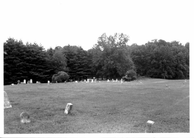
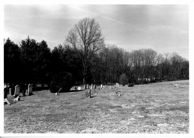
The cemetery is a large expanse of land primarily a level parcel. The cemetery contains headstones and footstones constructed either of marble or granite. The variety of markers include upright slabs, flat markers, rounded slabs, obelisks, pointed arch slabs. The earliest marker belongs to Robert Zinzy from 1851. Other family names include Quigrly, Barton, Chatman, Freeman, Taylor, Bell, Davage, Johnson, Pennington, Gwynn, Wicks, and Lyons. Two headstones are situated immediately to the rear of the church in front of the parish hall. These two markers belong to Sophie Winder, 1908, and Joshua Winder, 1926.
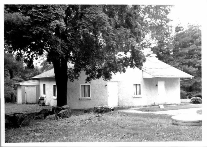
The stucco of the parish hall is engraved with [Ed]na Beary Parish Hall, built 1949.
CONTINUATION SHEET: BA- 928, Mount Zion A.M.E. Church
SECTION 8 PAGE 1
The Mount Zion African Methodist Episcopal (A.M.E.) Church dates to a mid-19th century period of settlement in the small community of Long Green, Maryland, located within the Eleventh District of Baltimore County. The Eleventh District is bounded to the south by the Twelfth District, to the north by the Tenth District, to the east by Harford County, and to the west by the Ninth and Tenth Districts. Historically it has been one of the largest districts in Baltimore County. During the 1850s Long Green was largely agricultural and traversed primarily by rolling farmland.
The congregation of the Mount Zion African Methodist Episcopal (A.M.E.) Church was established in 1849. The first African Methodist Episcopal Church was started in 1787 in Philadelphia, Pennsylvania. This church was established by African American congregates that seceded from St. George's Methodist Episcopal Church in Philadelphia. Richard Allen (1760-1831), the founder of the newly established church, was born a slave in 1760 and purchased his freedom prior to 1780. It was in 1780 that Allen began preaching. In 1799, Richard Allen was officially ordained a minister. The Blacksmith Shop Meeting House was the first church that was organized by Allen and other African American men that left the St. George's M.E. Church. Sited on 6th Street between Lombard and Pine Streets in Philadelphia, the first A.M.E. Church was established and has remained since. The first church was called the Bethel A.M.E. Church beginning in 1791. The African Methodist Episcopal denomination was officially organized in 1816 at a conference held in Philadelphia. Allen was elected as the first Bishop of the General Conference. Today, eighteen active Bishops reside over the conferences of the A.M.E. Church and more than a million members are in the church throughout the United States, Canada, South America, West Africa, South African, and the West Indies.1
Notable families of the original Mount Zion A.M.E. Church in Long Green include the Bowleys, Coles, Quickleys, Bouldens, Johnsons, Hawkins, and Bells. As the congregation grew throughout the early 1850s, members sought to purchase an acre of land upon which they could build a church and cemetery. Nathaniel Peck, who owned a tract of John Hawkins' land, conveyed a small parcel to the Mount Zion Church. Elisha Johnson, Grafton Quickley, Isaac Bowley, Henry Boulden, and William Cole were elected to act as trustees for the church. On January 9, 1855 they signed a contract for the land, and on January 16, 1855, after $10 was raised, the trustees took the deed to Towson to be recorded. Nathaniel Peck owned the land since 1829.2 It was specifically written in the deed in 1855 that the land was going to be used to build a church for the congregation. Later that year, the first Mount Zion African Episcopal Church, a small wooden structure, was built by the congregation.3 The vernacular building is representative of many unembellished ornamented wood-frame churches constructed throughout rural Baltimore County in the mid-1800s.
The 1877 Hopkins Atlas of Baltimore County illustrates that during the 1860s and 1870s the town of Long Green began to develop around the intersection of Manor Road and
CONTINUATION SHEET: BA- 928, Mount Zion A.M.E. Church
SECTION 8 PAGE 2
Long Green Pike. A store was cited on the northwest comer of the intersection, near Mount Zion Church. Several churches and a schoolhouse were also cited in and around the community. During this time period, members of the church came not only from Long Green, but from neighboring towns such as Hartley Mills, Glen Arm, Sweet Air, Notch Cliff, Honeysuckle Hill, Fork, Hydes, Quickleyville, Noble Comer, Bone Mill, and Towson. In 1871, under the pastorage of Rev. W.T. Brown, a larger building was constructed for Mount Zion African Episcopal Church.4
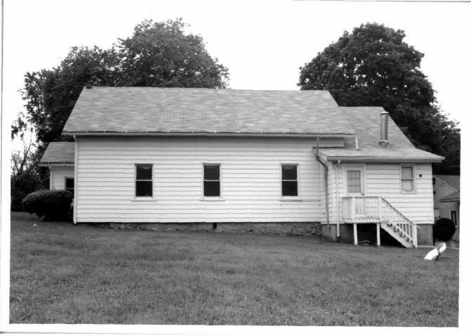
The 1915 Bromley Map of Baltimore County exhibits that after the completion of the Baltimore and Delta Railroad, passing within a mile of Long Green, the area became more thickly settled.5 In 1917, Mt. Zion Church acquired property on Kane Road and built a parsonage. In 1929, the church purchased two acres of land for $1,100 from P. Edward Graw and John G. Graw to expand the cemetery and build a thirty-foot road. In 1936, a one-story addition was constructed on the church's rear elevation. Ten years later, Mount Zion was renovated and a new floor and choir loft was installed. In 1952, a one-and a half-story parish hall was built, and in 1954, a new pulpit was constructed. On July 20, 1956 a fire destroyed the altar, pulpit, and much of the interior. Renovations took place through February of 1958. The 1871 foundation remains in place and the 1851 cemetery is still used for internment.6
List of Pastors7:
W.T. Brown Jacob C. McEady G.A. Hawkins James G. Martin (1935-42) W.E. Spratley (1943-48) D.E. Makell (1948-52) W.A. Bell (1952-54) Ellison B.Burch( 1954-67) James C. Steward (1967-81) Maurice Wilson (1981-83) Edgar Carter (1983-85) Milford Rhodes (1985-88) Theodore McPherson (1988-present)
January 16, 1855 Nathaniel Peck to Trustees of Mt. Zion A.M.E. Church Baltimore County Courthouse Liber H.M.F. 10 Folio 343
CONTINUATION SHEET: BA- 928, Mount Zion A.M.E. Church
SECTION 8 PAGE 3
1 Kristie Baynard, "Lomax African Methodist Episcopal Church," National Register Nomination. Virginia Department of Historic Resources, Richmond: April 2003. 2 Baltimore County Courthouse, Liber H.M.F. 10 Folio 343. Towson: January 16, 1855. 3 Baltimore County Courthouse, Liber H.M.F. 10 Folio 343. Towson: January 16, 1855. 4 Atlas of Baltimore County, Maryland (Philadelphia, PA: G. M. Hopkins, 1877). 5 Map of Baltimore County (Philadelphia, PA: G. W. Bromley, 1915). 6 Mt. Zion A.M.E. Church 150th Church Anniversary: Souvenir Journal. Not Published: May 2003. 7 Mt. Zion A.M.E. Church 150th Church Anniversary: Souvenir Journal. Not Published: May 2003.
CAPSULE SUMMARY BA- 928 Mt. Zion A.M.E. Church 13010 Manor Road Long Green, Baltimore County 1855 Private
The Mt. Zion A.M.E. Church dates to an early to mid-19th century period of settlement in the small
community of Long Green in District 11 of Baltimore County. According to prior documentation, the
congregation pre-dates 1820, the year in which members purchased the first parcel of land on which to
establish a church and cemetery. The vernacular building, constructed in 1855, is representative of many
unornamented wood frame churches constructed throughout rural Baltimore County in the mid-1800s.
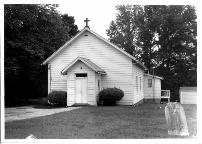
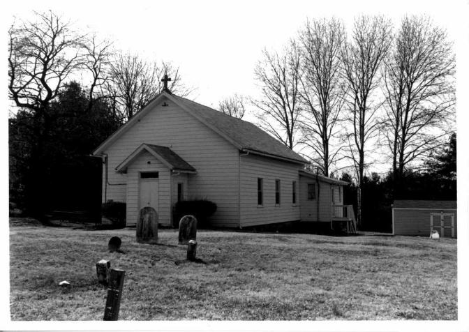
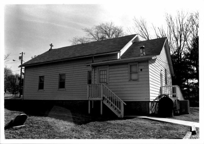
The Mt. Zion A.M.E. Church is a one-story wood frame building clad in vinyl siding. The vernacular
building sits on a solid random rubble stone foundation and has a front gable roof clad in asphalt shingles.
The three-bay-wide facade, or east elevation, is marked by a one-story gabled projecting central entrance
bay. This bay is pierced by one flush double-leaf wood door with a one-light transom and square-edged
wood surround. The sides of the bay each feature one 1/1 window with a vinyl surround. The building was
remodeled in 1871 and again in 1936, at which time a one-story addition was constructed on the rear
elevation. A cemetery that dates to 1851 is located to the north of the church and is comprised of
approximately 100 grave markers arranged in north-south rows that face east and west. The majority of the
markers have been carved from marble and granite and are primarily upright slabs. The cemetery is still in
use for internment. To the west of the church is a one-and-a-half-story parish hall of cinderblock
construction that dates to circa 1960.
Maryland Historical Trust Maryland Inventory of Historic Properties Form
Inventory No. BA- 928
1. Name of Property (indicate preferred name)
historic
other Mt. Zion A.M.E. Church
2. Location street and number 13010 Manor Road not for publication
city, town Long Green __ vicinity
county Baltimore County
3. Owner of Property (give names and mailing addresses of all owners)
name Mt. Zion M.E. Church
street and number 13010 Manor Road telephone Not Available
city, town Long Green state MD zip code 21092
4. Location of Legal Description A" courthouse, registry of deeds, etc. Baltimore County Courthouse liber Not Available folio Not Available
city, town Towson tax map 53 tax parcel 305 tax ID number 1113075250
5. Primary Location of Additional Data Contributing Resource in National Register District Contributing Resource in Local Historic District Determined Eligible for the National Register/Maryland Register Determined Ineligible for the National Register/Maryland Register
. Recorded by HABS/HAER Historic Structure Report or Research Report at MHT Other:
6. Classification
Category ^—district X buildinq(s)
—.___structure ___site
— object
Ownership —.__public
X private both
Current Function —^__agriculture ___commerce/trade
-__defense X domestic
— education funerary government
—___health care —.__industry
Resource Count Jandscape _ recreation/culture _religion _social Jransportation -work in progress .unknown _vacant/not in use -other:
Contributing
—I — 1
Noncontributing —J buildings
.___ sites structures objects
1 Total
Number of Contributing Resources previously listed in the Inventory
7. Description Inventory No. BA- 928
Condition
excellent deteriorated X good ruins
fair altered
Prepare both a one paragraph summary and a comprehensive description of the resource and its various elements as it exists today.
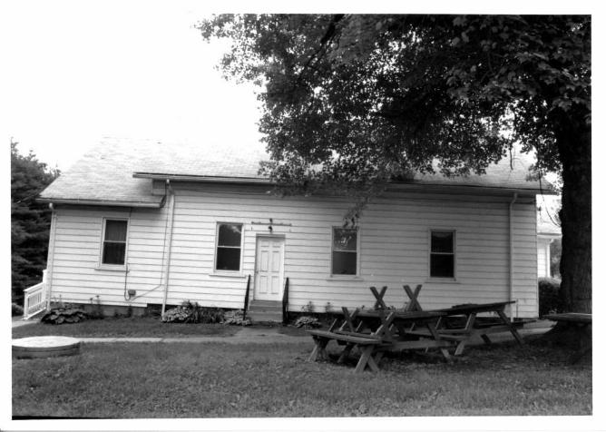
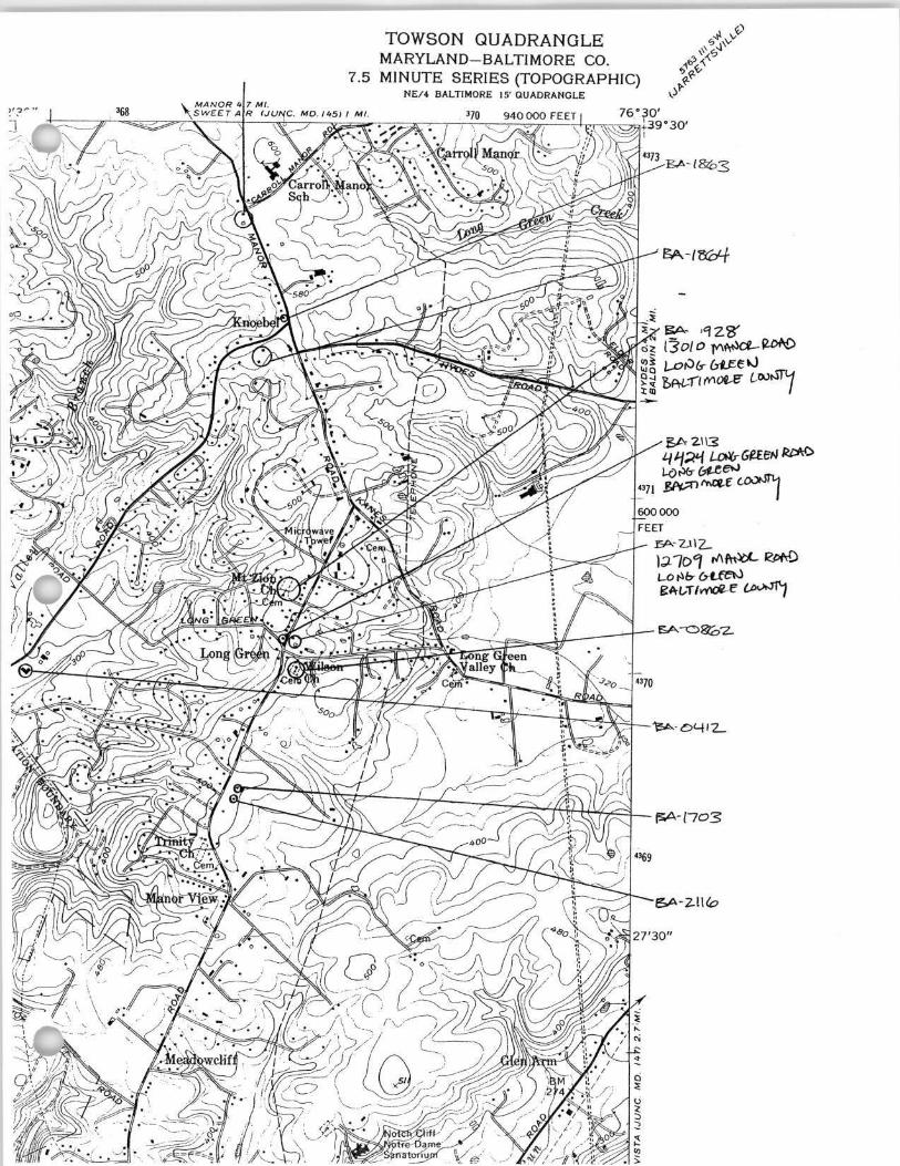
The Mt. Zion A.M.E. Church, a one-story wood frame building clad in vinyl siding, was constructed in 1855. The vernacular building sits on a solid random rubble stone foundation and has a front gable roof clad in asphalt shingles. The three-bay-wide facade, or east elevation, is marked by a one-story gabled projecting central entrance bay. This bay is pierced by one flush double-leaf wood door with a one-light transom and square-edged wood surround. The sides of the bay each feature one 1/1 window with a vinyl surround. The building was remodeled in 1871 and again in 1936, at which time a one-story addition was constructed on the rear elevation.
A cemetery that dates to 1851 is located to the north of the church and is comprised of approximately 100 grave markers arranged in north-south rows that face east and west. The majority of the markers have been carved from marble and granite and are primarily upright slabs. The cemetery is still in use for internment.
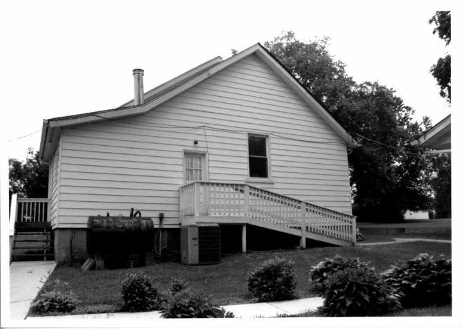
To the west of the church is a one-and-a-half-story parish hall that dates to circa 1960. The cinderblock building has been parged with stucco. The cross gable roof is clad with asphalt shingles. The building's facade is pierced by one flush single-leaf wood door and two one-light fixed windows with square-edged wood surrounds and parged sills.
8. Significance Inventory No. BA- 928
Period
_ 1600-1699 _ 1700-1799 X 1800-1899 X 1900-1999
2000-
Areas of Significance
agriculture archeology
X architecture _ art
commerce communications community planning conservation
Check and justify below
economics health/medicine performing arts education industry philosophy engineering invention politics/government entertainment/ landscape architecture religion
recreation law science ethnic heritage literature social history exploration/ maritime history transportation settlement military other:
Specific dates 1855-present Architect/Builder Unknown
Construction dates 1855
Evaluation for:
National Register Maryland Register not evaluated
Prepare a one-paragraph summary statement of significance addressing applicable criteria, followed by a narrative discussion of the history of the resource and its context. (For compliance projects, complete evaluation on a DOE Form - see manual.)
The Mt. Zion A.M.E. Church dates to an early to mid-19th century period of settlement in the small community of Long Green in District 11 of Baltimore County. According to prior documentation, the congregation predates 1820, the year in which members purchased the first parcel of land on which to establish a church and cemetery.1 The vernacular building, constructed in 1855, is representative of many unornamented wood frame churches constructed throughout rural Baltimore County in the mid-1800s.
By 1850, the land that would become the town of Long Green was still largely rural and traversed primarily by rolling farmland. A general store and post office were located along Manor Road south of Long Green Pike's terminus at Manor Road.2 By 1877, however, Long Green Pike had been extended past Manor Road and the town of Long Green, which was also known as Unionville, was centered on that intersection. A store was sited on the northwest corner of the intersection of Long Green Pike and Manor Road. In addition, several churches and a schoolhouse were located in and around the community. By the late 1870s, much of the land, although it remained rural in character, had been subdivided for use as smaller farms.3 Long Green continued to develop slowly through the early 20th century, and by 1915, several additional residences were built along the two main roads. Long Green has retained its rural, agrarian character through the late 20 century.
Baltimore County Historic Inventory. J.C. Sidney, Map of the City and County of Baltimore, Maryland, from Original Surveys (Baltimore, MD: James M. Stephens, 1850).
3 Atlas of Baltimore County, Maryland (Philadelphia, PA: G. M. Hopkins, 1877). 4 Map of Baltimore County (Philadelphia, PA: G. W. Bromley, 1915).
9. Major Bibliographical References inventory NO. BA- 92s Atlas of Baltimore County, Maryland,. Philadelphia, PA: G. M. Hopkins, 1877. Baltimore County Historic Inventory. Brooks, Neal A. and Eric G. Rockel. A History of Baltimore County. Towson, MD: Friends of the Towson Library, Inc., 1979. Map of Baltimore County. Philadelphia, PA: G. W. Bromley, 1915. Scharf, J. Thomas. History of Baltimore City and County From the Earliest Period to the Present Day: Including Biographical
Sketches of Their Representative Men. Philadelphia, PA: Louis H. Everts, 1881. Reprinted by Higginson Book Company, Salem, MA.
Sidney, J. C. Map of the City and County of Baltimore, Maryland, from Original Surveys. Baltimore, MD: James M. Stephens, 1850
10. Geographical Data
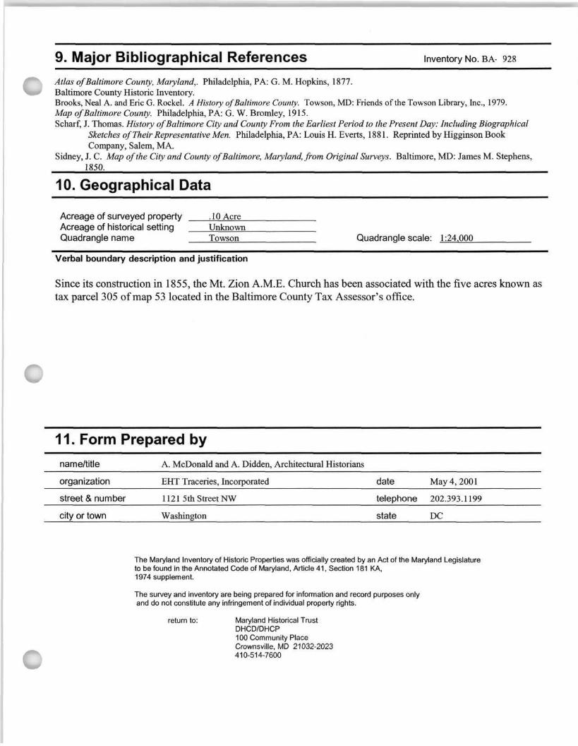
Acreage of surveyed property .10 Acre Acreage of historical setting Unknown Quadrangle name Towson Quadrangle scale: 1:24,000
Verbal boundary description and justification
Since its construction in 1855, the Mt. Zion A.M.E. Church has been associated with the five acres known as tax parcel 305 of map 53 located in the Baltimore County Tax Assessor's office.
11. Form Prepared by name/title
organization
street & number
city or town
A. McDonald and A. Didden, Architectural Historians
EHT Traceries, Incorporated
1121 5th Street NW
Washington
date
telephone
state
May 4, 2001
202.393.1199
DC
The Maryland Inventory of Historic Properties was officially created by an Act of the Maryland Legislature to be found in the Annotated Code of Maryland, Article 41, Section 181 KA, 1974 supplement.
The survey and inventory are being prepared for information and record purposes only and do not constitute any infringement of individual property rights.
return to: Maryland Historical Trust DHCD/DHCP 100 Community Place Crownsville, MD 21032-2023 410-514-7600
TOWSON QUADRANGLE MARYLAND-BALTIMORE CO.
7.5 MINUTE SERIES (TOPOGRAPHIC) NE/4 BALTIMORE 15' QUADRANGLE
C fcA-928 MOUNT ZION A.M.E. CHURCH - 1855 - (West side of) 13010 Manor Road, 0.2 mile north of Long Green Road. Frame chapel with clapboard siding built in 1855 and remodeled in 1871 and again in 1936 according to a trustee's interpretation of a cornerstone that reads: "Mount Zion A.M.E. Church/Rev. J.G. Martin/1936/1871/1855." The first parcel of land dates to c. 1820, and formal incorporation took place in 1867. In 1870, the trustees acquired an additional acre from the adjoining Ravenshurst tract for $51.00 plus the promise that church-goers would not wear paths through the fields of David C. Trimble. The 1877 Hopkins atlas showed "Ch. Cem." and no