TS01A - Administration in Africa 1 – 6648 1/17 Wasiu A. O. Akewusola Social Housing : A Means of Even Development for the Developing Nations –Nigeria as a Case Study FIG Working Week 2013 Environment for Sustainability Abuja, Nigeria, 6 – 10 May 2013 10/17 Addis Ababa: The Road Map to Progress through Securing Property Rights with Real Property Registration System Tarek ZEIN; Dr. Paul HARTFIEL; Germany, and Zerihun Amdemariam BERISSO, Ethiopia Key words: cadastre, immovable property registration, land information system, real property registration, street addressing system, parcel, land administration domain model, common cadastral database SUMMARY In September 2009 the Addis Ababa City Government called for tenders for the development of a new real property registration system and a new land information (cadastre) system. Development in the city, the redevelopment of slum areas, investment in building and infrastructure and the organisation of services was being hindered by the lack of up-to-date, accurate and reliable cadastre. The city additionally requested the implementation of a new street addressing system and the updating of existing cadastral map data. The new systems were viewed as pilots which could be ported over the entire country. Since the Addis Ababa project was to form the basis for a national solution, the transfer of knowledge and expertise to employees within Addis Ababa governmental agencies was considered vital. In addition it was considered essential that local people maintained ownership of the project throughout its development and implementation. Hansa Luftbild, a German based, geo-information and mapping company, with extensive international experience acquired the project and worked closely with the local administration to implement it. This paper gives an overview of the establishing of the new real property and cadastre system, the new addressing system, the updating of the cadastral map and the support, training and consultancy services provided by the company.
Transcript
TS01A - Administration in Africa 1 – 6648 1/17
Wasiu A. O. Akewusola
Social Housing : A Means of Even Development for the Developing Nations –Nigeria as a Case Study
FIG Working Week 2013
Environment for Sustainability
Abuja, Nigeria, 6 – 10 May 2013
10/17
Addis Ababa: The Road Map to Progress through Securing Property
Rights with Real Property Registration System
Tarek ZEIN; Dr. Paul HARTFIEL; Germany, and Zerihun Amdemariam BERISSO,
Ethiopia
Key words: cadastre, immovable property registration, land information system, real property
registration, street addressing system, parcel, land administration domain model, common
cadastral database
SUMMARY
In September 2009 the Addis Ababa City Government called for tenders for the development
of a new real property registration system and a new land information (cadastre) system.
Development in the city, the redevelopment of slum areas, investment in building and
infrastructure and the organisation of services was being hindered by the lack of up-to-date,
accurate and reliable cadastre. The city additionally requested the implementation of a new
street addressing system and the updating of existing cadastral map data. The new systems
were viewed as pilots which could be ported over the entire country. Since the Addis Ababa
project was to form the basis for a national solution, the transfer of knowledge and expertise
to employees within Addis Ababa governmental agencies was considered vital. In addition it
was considered essential that local people maintained ownership of the project throughout its
development and implementation. Hansa Luftbild, a German based, geo-information and
mapping company, with extensive international experience acquired the project and worked
closely with the local administration to implement it. This paper gives an overview of the
establishing of the new real property and cadastre system, the new addressing system, the
updating of the cadastral map and the support, training and consultancy services provided by
the company.
TS01A - Administration in Africa 1 – 6648
Wasiu A. O. Akewusola
Social Housing : A Means of Even Development for the Developing Nations –Nigeria as a Case Study
FIG Working Week 2013
Environment for Sustainability
Abuja, Nigeria, 6 – 10 May 2013
Addis Ababa: The Road Map to Progress through Securing Property
Rights with Real Property Registration System
Tarek ZEIN; Dr. Paul HARTFIEL; Germany, Zerihun Amdemariam BERISSO,
Ethiopia
1. INTRODUCTION
Addis Ababa, capital of Ethiopia, has witnessed rapid urban expansion over the last 20 years.
This has put pressure on the city’s land resources leading to increasing areas of slum
settlement. The Addis Ababa City Government (AACG) has recently instigated programs for
the redevelopment of slum settlements and the development of new housing areas, both of
which require reliable and consistent systems of real property rights and ownership.
Land is a major resource essential for the future development of Addis Ababa. Enhancing the
optimal utilization and administration of this resource is a fundamental factor in the
development and furtherance of good governance. To this end Addis Ababa City
Administration (AACA) is committed to securing and clarifying land and property rights and
promoting reliable property transaction processes through registration. These aims can
primarily be achieved with up-to-date city cadastral map data and a robust geo-database
system.
In 1996 the AACA implemented a cadastral project to register all property owners so that
valuation and taxes could be applied to properties. A multi-purpose cadastre was established
and data collected to support urban planning, land and property transfers, the issuing of
building permits and title deeds, and compensation payments. Over time insufficient
integration between the various land information systems and inefficient updating
mechanisms led to a significant erosion of the cadastral map’s reliability. This led to
widespread informal property settlements, land encroachment, inadequately secured land
records and a general mistrust in official land transaction processes.
To alleviate these problems, in 2009, the AACG made a decision to develop and implement a
new integrated land information system based on information communications technology
(ICT). The primary purpose of the system was to establish real property registrations and a
land cadastre system able to support land registration processes and municipal functions.
On taking this decision the AACG called for tenders from international experts who could
help in the process. This paper describes the processes involved in updating the AACA’s
existing cadastral map data, the development and implementation of a new real property
registration system and a new land information system, and the establishment of a street
addressing system.
2. PREVIOUS SITUATION
TS01A - Administration in Africa 1 – 6648
Wasiu A. O. Akewusola
Social Housing : A Means of Even Development for the Developing Nations –Nigeria as a Case Study
FIG Working Week 2013
Environment for Sustainability
Abuja, Nigeria, 6 – 10 May 2013
Up until implementation of the current project Addis Ababa had operated an increasingly
unreliable manual real property registration system. The cadastre map being used was an
extract of parcels and buildings from a 1996 topographic map prepared for the design of the
water supply system. It did not cover the entire city and hadn’t been updated since 1996. The
parcels and the buildings were not identified by a consistent and unique numbering system
thus the links between the registry information and the parcels were unreliable. The street
addressing system was not well designed and only partially implemented throughout the city.
This adversely affected the provision of reliable municipal services. Moreover, the
registration processes were carried out within a sub-section of an authority, and simultaneous
update of the cadastre was not carried out.
Until recently the land and land related administration sector (LLRAS) of the city of Addis
Ababa was organised into three authorities / offices. The three-authority structure of the land
and land related administration sector (LLRAS) of Addis Ababa was organized into a
Building Permit Authority, Urban Renewal Project Office and Urban Planning and
Information Institute. The same administrative configuration is also set up for the ten sub-
cities of Addis Ababa and the 116 districts within Addis Ababa known as Woredas.
The real property registration was carried out by the land administration and building permit
authority (LABPA) and was based on title deeds registered in several books. The title deeds
were the official record of the rights on land.
For each of the sub-cities there are six (6) so called “Big Books” which are structured as
follows:
main book with the basic data (LABPA-01)
book of title deed transactions (LABPA-02)
book of mortgages (LABPA-03)
book of court injunctions (LABPA-04)
book of condominiums
book of condominium bank loans
Most of the information occurs two to three times in the books. This handwritten form of
registrations is prone to errors.
In addition to the books there is a tenure archive containing all documents relating to a
property. The archive is organized into folders. Each folder contains all documents related to
a property, such as the title deed or related court injunctions. The tenure archive is indexed by
sub-city, Woreda and house number. Some intermittent, but generally unsystematic, cross
checking of the written records is carried out.
The inconsistencies and irregularities in the organization of the cadastre and its information
were problematic. Manipulation of registration information, violation of planning and
building regulations, overlapping allotment of land, missing archive files, cumbersome
technical and administrative processes were amongst some of the problems caused by
TS01A - Administration in Africa 1 – 6648
Wasiu A. O. Akewusola
Social Housing : A Means of Even Development for the Developing Nations –Nigeria as a Case Study
FIG Working Week 2013
Environment for Sustainability
Abuja, Nigeria, 6 – 10 May 2013
weaknesses in the system. The system was not transparent and did not fulfill customer
demand for reliable services and guarantee of land tenure.
In seeking to alleviate this situation the city administration identified key priorities for the
facilitating of the development of new up-to-date, sustainable and reliable real property
registration and land information (cadastre) systems. One of the key priorities was the setting
up of an appropriate administrative framework, including the establishment of a new
Immovable Property Registration and Information Agency (IPRIA) of Addis Ababa mandated
to operate the registration and land information (cadastre) systems.
3. PROJECT OBJECTIVE AND AIMS
In September 2009 AACG called for tenders for the development of new real property
registration and land information (cadastre) systems. The scope of work in the tender also
included updating of existing cadastre map data, design and implementation of a street
addressing system and support for the establishment of real property registration offices.
The objective of the project was to provide consultancy services and develop a cadastre (real
property registration and land information) system for Addis Ababa City Administration
(AACA) in Ethiopia. It was a two phase project with the following components:
Phase 1:
updating cadastral map
support for the establishment of municipal real property registration offices
requirements analysis, design and specification of real property registration and land
information (cadastre) systems
development of addressing system
Phase 2:
development and implementation of real property registration and land information
(cadastre) systems
support for the establishment of municipal real property registration offices
The consultancy services were to provide expert knowledge and advice for the setting up of
immovable property registration offices as well as the update of existing cadastre maps. The
development of the cadastre system included the implementation of a real property
registration system as well as a land information system.
Hansa Luftbild an international geo-information and mapping company based in Germany
tendered for, and won the project.
The Integrated Land Management Information System Project Coordination Office
(ILMISPCO) at AACA had overall responsibility for implementation and management of the
project.
TS01A - Administration in Africa 1 – 6648
Wasiu A. O. Akewusola
Social Housing : A Means of Even Development for the Developing Nations –Nigeria as a Case Study
FIG Working Week 2013
Environment for Sustainability
Abuja, Nigeria, 6 – 10 May 2013
4. PROJECT APPROACH AND METHODOLOGY
Hansa Luftbild’s methodology and approach followed international standards. In order to
develop and implement the new system, it was necessary to establish special working groups
(WG). The working groups provided input to and support for Hansa Luftbild throughout the
project duration. In addition the company was able to transfer know-how to the local
professionals within the working groups.
The working groups, who were supervised by Hansa Luftbild, were involved in the entire
development and implementation process in order to guarantee continued sustainable use of
the implemented systems after completion of the contracted work.
The following paragraphs give detailed descriptions of the methodologies used for various
components of the project.
5. REQUIREMENTS ANALYSIS AND SPECIFICATION AND DESIGN OF
REAL PROPERTY REGISTRATION AND LAND INFORMATION
(CADASTRE) SYSTEMS
The objective of the requirements analysis for the real property registration and land
information (cadastre) systems was to model real property registration processes, and the
derivation of products and services from the database. The products and services were tailored
according to the requirements of the public and private sectors and the key input for the
analysis was gathered during visits to selected sub-cities and during thorough and ongoing
discussions with the project working groups. Analysis was carried out within the framework
of a business process model. The Ethiopian constitution and law accords its citizens land use
and property rights. These rights were taken into account during the requirements analysis.
The dynamic aspects of the real property registration system were described with use cases
which detailed the business processes of the real property registration sector. In total 19
business’ use cases were identified and detailed. The proposed systems were called Addis
Ababa Cadastre Information System (AA-CADIS) and Addis Ababa Land Information
System (AA-LIS).
The domain model of AA-CADIS describing the static aspects of the system, as such is the
data model. It was developed with reference to international standards such as ISO/TC 211
standard No. 19152 the “Land Administration Domain Model (LADM)”. The ISO conceptual
model was used to develop a concrete feature catalogue for Addis Ababa. The data model for
Addis Ababa consists of two parts, a real property registration database and a real estate
cadastre database. The real property registration (RPRS) database is non-spatial while the real
estate cadastre (RECS) database contains spatial data. These form the common cadastral
database (CCDB) which constitutes the platform of AA-CADIS. Figure 1 shows the structure
of AA_CADIS and AA-LIS.
TS01A - Administration in Africa 1 – 6648
Wasiu A. O. Akewusola
Social Housing : A Means of Even Development for the Developing Nations –Nigeria as a Case Study
FIG Working Week 2013
Environment for Sustainability
Abuja, Nigeria, 6 – 10 May 2013
The RPRS and the RECS are closely connected and operate on a common database to carry
out the cadastre and real property business processes. The RECS maintains and administers
the cadastre map data and its descriptive information and is linked to the real property
registration database. The AA-CADIS is the base of the spatial reference system of AA-LIS.
Figure 1: Structure of Addis Ababa cadastre information and land information systems
(Source: Hansa Luftbild, 2010)
Figure 2 shows the organisation of AA-CADIS and its relationship to other land sectors of
AACA.
TS01A - Administration in Africa 1 – 6648
Wasiu A. O. Akewusola
Social Housing : A Means of Even Development for the Developing Nations –Nigeria as a Case Study
FIG Working Week 2013
Environment for Sustainability
Abuja, Nigeria, 6 – 10 May 2013
Figure 2: Organization of AA-CADIS (Source: Hansa Luftbild, 2011)
AA-LIS was developed to support and provide an interface to services used by public
authorities and the private sector and is implemented on the basis of Open Geospatial
Consortium (OGC) web services standards, for example Web Map Service (WMS), Web
Feature Service (WFS) and Web Map Client.
6. UPDATING CADASTRAL MAP DATA
The updating of the cadastral maps was divided into 3 tasks:
Identification of Data Gaps, Assessment of Cadastral Map Quality and Production
of Updated Cadastral Map
Verification of the Sufficiency of Existing Ground Control
Development of a Unique Identification System
6.1 Identification of Data Gaps, Assessment of Cadastral Map Quality and
Production of Updated Cadastral Map
This first task was split into three sub-tasks.
Identification of Data Gaps To identify gaps the ortho-images, produced in 2005 / 2006, and the existing cadastre data
were compared. The existing data was analysed and results of the analysis can be summarized
TS01A - Administration in Africa 1 – 6648
Wasiu A. O. Akewusola
Social Housing : A Means of Even Development for the Developing Nations –Nigeria as a Case Study
FIG Working Week 2013
Environment for Sustainability
Abuja, Nigeria, 6 – 10 May 2013
that cadastre data exists for about 60% of the whole city of Addis Ababa and that new data
capture was necessary for 58.2% of the city while 41.8% of the city needed a data update.
Assessment of Cadastral Map Quality
To evaluate the quality of the cadastral map data, a two step comparison process was carried
out. First orthophotos produced in 2005 / 2006 were compared with existing cadastral map
data. Next orthophotos produced from aerial imagery acquired in 2010 were compared with
the cadastral map data.
The comparisons were made over the entire project area by superimposing cadastral map data
(vector) over the orthophotos. Changes were identified as is shown in Figure 3, a
representative area in the sub-city of Addis Ketema. The cadastral map data is superimposed
over the existing orthophoto tile.
Figure 3: Cadastral map data in selected area of the sub-city Addis Ketema
superimposed over 2005 / 2006 orthophoto (Source: Hansa Luftbild, 2011)
TS01A - Administration in Africa 1 – 6648
Wasiu A. O. Akewusola
Social Housing : A Means of Even Development for the Developing Nations –Nigeria as a Case Study
FIG Working Week 2013
Environment for Sustainability
Abuja, Nigeria, 6 – 10 May 2013
The two arrows indicate two representative situations:
The red arrow points to a difference between the shape of the wall boundary on
the ground and the cadastral boundary in the data set. During updating the
cadastral map data was revised to match the real ground situation.
The blue arrow points to a cadastral boundary which fits well with the foot print
of the wall. This fit was checked and confirmed during updating using a
photogrammetric stereo measurement method.
Major parts of the project area were treated as new mapping, rather than being updated and /
or having missing parcels added to the existing data set. This was due to significant changes
in the urban landscape having taken place across all the sub-cities of Addis Ababa.
Production of Cadastral Maps
New aerial photography was acquired in November 2010 in order to update and complete the
data coverage of Addis Ababa. The digital aerial photography was acquired at a ground
resolution averaging 17cm. This resolution was suitable for mapping at scale 1:2000 as well
as for producing digital orthophotos at a ground sampling distance (GSD) of 20cm which is
also equivalent to a map scale of 1:2000.
Figure 4 shows the new parcel data coverage after the updating. Figure 5 shows the existing
building data before and after the updating.
Figure 4: Old parcel coverage (left) compared with new parcel coverage after updating
(Source: Hansa Luftbild, 2010 and 2011)
TS01A - Administration in Africa 1 – 6648
Wasiu A. O. Akewusola
Social Housing : A Means of Even Development for the Developing Nations –Nigeria as a Case Study
FIG Working Week 2013
Environment for Sustainability
Abuja, Nigeria, 6 – 10 May 2013
Figure 5: Old building data coverage compared with new coverage after updating (Source:
Hansa Luftbild, 2011)
In addition to the parcels and buildings the street and road network was mapped and used to
set up the street addressing system.
The photogrammetric data capture in a 3D – stereo environment was carried out on a Bentley
MicroStation V8. After data capture the data was input in ESRI ArcGIS and processed so as
to generate closed polygons, to assign unique identification numbers and to merge existing
attribute data to new polygons.
In statistical terms the final results and output of the updating can be summarized as follows:
359,897 parcels were generated (the initial estimate of AACA was 296,000 parcels) of which
less than 0.1% were unchanged parcels and around 49% were new parcels, and around 51%
were changed parcels.
The number of building or construction features mapped was 1,145,690.
6.2 Verification of the Sufficiency of Existing Ground Control
The object of this task was to assess if the existing ground control points provided sufficient
coverage for future accurate cadastral surveys.
One hundred and fifty ground control points have been established by the Ethiopian Mapping
Agency (EMA) in Addis Ababa. These fall within the city boundaries and are distributed
within the ten sub-cities.
TS01A - Administration in Africa 1 – 6648
Wasiu A. O. Akewusola
Social Housing : A Means of Even Development for the Developing Nations –Nigeria as a Case Study
FIG Working Week 2013
Environment for Sustainability
Abuja, Nigeria, 6 – 10 May 2013
During the ground points marking expedition in June 2010 surveyors checked the 150 ground
control points and found that 31 points were damaged, or buried, or inaccessible.
Furthermore the distribution of the current ground control points was not suitable to adjust the
photogrammetric block. Therefore 62 additional ground control points were determined and
surveyed for that adjustment.
On the basis of the foregoing it was concluded that the existing ground points provided
insufficient coverage for future cadastral surveys. This would particularly be the case when a
highly accurate survey is required as in determining the exact area of land parcel or
subdivision of blocks of land.
Hansa Luftbild recommended that AACA implement either one of the following two
approaches in order to apply cadastral field methods to adjudicate existing parcels or to
survey new ones:
1. establishment of an active GPS station network, or
2. densification of the existing ground control points to 1 point per square kilometre with a
horizontal and vertical accuracy of 5cm and better
6.3 Development of a Unique Identification System
To locate a parcel in the cadastral map, it is necessary to link the parcel number with the
geometry of the map, i.e. the geodetic reference system. Therefore an independent district and
numbering concept for cadastral purposes with the Woreda as the smallest cadastre district
was proposed by Hansa Luftbild and accepted by AACA.
This unique identification numbering system for the parcels consists of 14 digits with the
following information code:
rrcccsswwppppp
rr number or code for the region (AA for Addis)
ccc number of city (000 for Addis)
ss number of sub-city (e.g.: 06 for Bole, 08 for Nifas Silk Lafto)
ww number of Woreda (e.g.: 10 at Bole)
ppppp number of parcel (00001, 00002, 00003, …)
This concept uses parcel boundaries as district boundaries and includes road, railway, and
river parcels. It is intended that this numbering will remain constant regardless of any future
changes in administrative boundaries. Furthermore it is very similar to the German system
which has continued to run reliably for more than 100 years. The advantages of this solution
are:
1. it is independent of future changes in administrative structure;
2. database consistency checking is simple, area coverage of a parcel within a cadastre
district (Woreda) is possible;
3. a special numbering concept for roads, railways and rivers is not needed.
TS01A - Administration in Africa 1 – 6648
Wasiu A. O. Akewusola
Social Housing : A Means of Even Development for the Developing Nations –Nigeria as a Case Study
FIG Working Week 2013
Environment for Sustainability
Abuja, Nigeria, 6 – 10 May 2013
All buildings inside the parcels were also captured and assigned a unique identification
number similar to the parcel identification number however consisting of 15 digits instead of
14 due to the large number of buildings.
7. ESTABLISHMENT OF ADDRESSING SYSTEM
Until recently Addis Ababa lacked a fully functioning and cohesive addressing system,
having only unsystematic and incomplete street addressing. Furthermore no single
organisation was responsible for the assigning of addresses (ie house numbers).
The lack of an addressing system meant that AACA could not provide the public and private
sectors with information and services, relating to address location and street information.
Locations in Addis Ababa were described by referring to commonly known landmarks, and
appointments or deliveries were handled through guides or make shift maps. This hindered
the development and operation of the postal, public transport, security and rescue services.
According to the Addis Ababa Construction and Road Authority (AACRA) Addis Ababa
currently has approximately 7,400 public road segments suitable for vehicle traffic, including
paved and gravel roads.
The development of the addressing system was of critical importance and was foundational to
the current project. Working Group 3 worked on and developed key concepts / solutions for a
workable addressing system. The final concept agreed to by AACA was based on data
published in the World Bank’s manual “Street Addressing and the Management of Cities”. To
implement the agreed concept a street addressing unit was established within AACA.
Using the methodology outlined in the World Bank publication, a training manual containing
12 data sheets was prepared. These defined and specified the major components required in an
effective street addressing system.
Two areas were chosen for piloting the implementation of the street addressing system. The
two pilot areas were used to derive an estimated budget for the implementation. The cost
estimation given by the World Bank manual starts at 0.50USD and goes up to 5.00USD. In
line with these estimates the costs for Addis Ababa at today’s exchange rate would be around
3.00USD (50 Birr) per registered city inhabitant.
8. SUPPORT FOR THE ESTABLISHMENT OF REAL PROPERTY
REGISTRATION OFFICES
Supporting the establishment of the municipal real property registration offices was an
important service delivered by Hansa Luftbild.
The key issues addressed during the consultancy period were:
operational and procedural development and support;
TS01A - Administration in Africa 1 – 6648
Wasiu A. O. Akewusola
Social Housing : A Means of Even Development for the Developing Nations –Nigeria as a Case Study
FIG Working Week 2013
Environment for Sustainability
Abuja, Nigeria, 6 – 10 May 2013
public and stakeholder information, education and communication;
strategic management and business plan preparation; and
training.
The Addis Ababa City Government’s Proclamation No. 22 /2010 established the Immovable
Property Registration and Information Agency (IPRIA). The proclamation which came into
force on the 7th
of June 2010 declared the IPRIA agency to be a legal entity directed by a
board accountable to the city manager. In addition to IPRIA’s head office the agency retains
an office in each sub-city. Figure 6 shows the functions of IPRIA in relation to the other
existing land and land related administration sector (LLRAS).
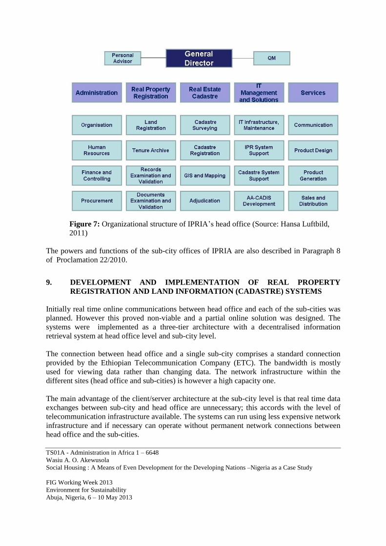
Figure 6: Functions of IPRIA within LLRAS (Source: AACA and Hansa Luftbild, 2011)
The principal tasks of IPRIA’s head office are defined in Paragraph 7 of Proclamation No.
22/2010. Hansa Luftbild recommended that IPRIA’s organizational structure be made
congruent with the business use cases as defined in the requirements analysis. Figure 7 shows
the structure of the agency at head office level.
TS01A - Administration in Africa 1 – 6648
Wasiu A. O. Akewusola
Social Housing : A Means of Even Development for the Developing Nations –Nigeria as a Case Study
FIG Working Week 2013
Environment for Sustainability
Abuja, Nigeria, 6 – 10 May 2013
Figure 7: Organizational structure of IPRIA’s head office (Source: Hansa Luftbild,
2011)
The powers and functions of the sub-city offices of IPRIA are also described in Paragraph 8
of Proclamation 22/2010.
9. DEVELOPMENT AND IMPLEMENTATION OF REAL PROPERTY
REGISTRATION AND LAND INFORMATION (CADASTRE) SYSTEMS
Initially real time online communications between head office and each of the sub-cities was
planned. However this proved non-viable and a partial online solution was designed. The
systems were implemented as a three-tier architecture with a decentralised information
retrieval system at head office level and sub-city level.
The connection between head office and a single sub-city comprises a standard connection
provided by the Ethiopian Telecommunication Company (ETC). The bandwidth is mostly
used for viewing data rather than changing data. The network infrastructure within the
different sites (head office and sub-cities) is however a high capacity one.
The main advantage of the client/server architecture at the sub-city level is that real time data
exchanges between sub-city and head office are unnecessary; this accords with the level of
telecommunication infrastructure available. The systems can run using less expensive network
infrastructure and if necessary can operate without permanent network connections between
head office and the sub-cities.
TS01A - Administration in Africa 1 – 6648
Wasiu A. O. Akewusola
Social Housing : A Means of Even Development for the Developing Nations –Nigeria as a Case Study
FIG Working Week 2013
Environment for Sustainability
Abuja, Nigeria, 6 – 10 May 2013
Updates of the AA-CADIS (ie RPRS and RECS) system are not directly implemented on the
central CCDB but through data maintenance jobs which are generated in the sub-cities at set
times.
The RPRS client is a web application and is invoked from a local applications server in each
of the 10 sub-cities and in head office. All maintenance operations are also carried out by data
maintenance jobs.
In each sub-city servers were installed for the applications, the local data repository, the
database and the OGC services. These services are used to provide access to the data
repositories of the RPRS and RECS clients.
The replication of data from head office to the sub-cities is performed using specially
developed replication tools since Oracle does not provide such tools for spatial data.
The three tier architecture consists of:
client layer, responsible for presentation and user interaction
service layer, and
data layer
The RPRS and RECS are implemented at the client layer and their applications are connected
to the AA-CADIS database server. One client maintains the RPRS and the other maintains the
RECS of the core business processes. The RECS was implemented as a Bentley Map
application and RPRS as Microsoft Windows application. The basic framework is Microsoft
.Net. The service layer provides the services which can be used by the applications at the
client layer as well as by external applications. Two components reside on the service layer,
namely AA-CADIS and AA-LIS. The data layer holds the database consisting of two logical
data sets. One set is for the real property (non-spatial) data while the other contains spatial
data and its descriptive attributes. The real estate cadastral data set contains three types of
data; parcels, buildings and fences. The real property registration data set consists of data of
ownership and all associated attributes. Ownership relates to a parcel and/or a building.
All registration offices work with the current data while head office owns and maintains the
data. The two client applications use only the necessary relevant data from both data sets and
can only change the data applicable to their specific tasks. This helps ensure data security.
10. CONCLUSION
In conclusion the Addis Ababa City Administration in close co-operation with Hansa Luftbild
was able to develop a new street addressing system and two working and practical real
property registration and land information (cadastre) systems within the confines of the
telecommunications infrastructure available. These two systems are being used to support
many services and will develop the confidence and trust of the public with regard to legal land
use right and ownership of property. During the development period the local staff acquired
TS01A - Administration in Africa 1 – 6648
Wasiu A. O. Akewusola
Social Housing : A Means of Even Development for the Developing Nations –Nigeria as a Case Study
FIG Working Week 2013
Environment for Sustainability
Abuja, Nigeria, 6 – 10 May 2013
skills and thus are able to run the systems independently. The two systems are populated with
up-to-date cadastral map data produced by Hansa Luftbild and run at the newly established
real property registration agency of the city. As well as being specifically tailored to AACG
specifications the two systems were simultaneously developed to comply with international
and Open Geospatial Consortium (OGC) standards, thus guaranteeing their transparency and
interoperability, locally, regionally and internationally. From this perspective the solution in
Addis Ababa can be seen as a blue print for Ethiopia at a national level and as potentially
utilizable throughout the African continent.
REFERENCES
City Government of Addis Ababa, Integrated Land Management Information System
Development Project Coordination Office (2009). Request for Proposals Document for the
Procurement of Consultancy Services
City Government of Addis Ababa – Addis Negari Gazeta (2010). The Addis Ababa City
Government Immovable Property Registration and Information Agency Establishment
Proclamation 22/210
Farvacque-Vitkovic, C.; Godin, L.; Leroux, H.; Verdet, F.; Chavez, R. (2005). Street
Addressing and the Management of Cities, World Bank D.C.
Kaufmann, Jürg; Steudler, Daniel (2008). Cadastral 2014 A Vision for a Future Cadastre
System, FIG International Federation of Surveyors
Lemmen, C.; van Oosterom, P.; Uitermark, H.; Thompson, R.; Hespanha J. (2009).
Transforming the Land Administration Domain Model (LADM) into an ISO Standard