Project features include various bikeway facilities and treatments designed to make the streets safer and more comfortable for people who bike, walk, drive, and take transit. On busy streets, this generally means physically separating people biking from motor vehicle traffic. On quieter or residential streets, this involves the implementation of traffic calming features such as traffic circles and speed cushions. Background The project will help fulfill the vision laid out in the San Diego Regional Bike Plan, which aims to make riding a bike a safer and more convenient choice for everyday travel. The Border to Bayshore Bikeway project is a vital part of the regional bike network, GO by BIKE, and a high-priority project funded through the Regional Bike Plan Early Action Program. Extensive outreach was conducted for the project, with four community meetings held for community members to give input on route options between 2017 and 2018. To get involved or to learn more about the project, visit KeepSanDiegoMoving.com/ BordertoBayshore. Design The project improvements were strategically selected and designed to maximize safety for people riding bikes and walking. The following pages illustrate the project route and specific improvements – including descriptions, benefits, and images of key features. To sign up to receive project updates, visit KeepSanDiegoMoving.com/ SubscribeGObyBIKE. Border to Bayshore Bikeway Overview The Border to Bayshore Bikeway is a 6.5-mile bikeway that will connect the world’s busiest land border crossing at the San Ysidro Port of Entry to the Bayshore Bikeway in Imperial Beach. The bikeway will provide residents and visitors with a safer active transportation option to travel between the Mexican border at San Ysidro, San Diego, and Imperial Beach. The Border to Bayshore Bikeway will primarily run along Beyer Boulevard, Iris Avenue, Oro Vista Road, Grove Avenue/ Ingrid Avenue/Halo Street, and 13th Street to provide safe biking connections within and between the San Ysidro community of San Diego and Imperial Beach. It also will make it safer and easier for people of all ages and comfort levels to bike to commercial centers, schools, transit stations, recreation, and other community destinations within San Ysidro and Imperial Beach, including the Imperial Beach Pier and the Bayshore Bikeway. The Bayshore Bikeway will eventually extend 24 miles around San Diego Bay, providing a vital and scenic connection to several waterfront cities and some of the region’s most attractive destinations. 401 B Street, Suite 800 San Diego, CA 92101 (619) 699-1900 Fax (619) 699-1905 sandag.org SANDAGregion @SANDAG SANDAGregion OTAY VALLEY REGIONAL PARK TIJUANA COUNTY OPEN SPACE PRESERVE O TAY M E S A R D . CAMINO D E L A P L A Z A PICADOR BLVD. BEYER BLVD. HOLLISTER ST. 27TH ST. BEYER BLVD. E BEYER BLVD. PICCARD AVE. PALM AVE. DEL SOL BLVD. W SAN YSIDRO BLVD. DAIRY MART RD. DEL SUR BLVD. PARK AVE. HOLLISTER ST. SATURN BLVD. IMPERIAL BEACH BLVD. GROVE AVE. / HALO ST. / INGRID AVE. IRIS AVE. 13TH ST. DENN E R Y R D . Bayshore Bikeway Border to Bayshore Alignment LEGEND UNITED STATES MEXICO @SANDAGregion Border to Bayshore Bikeway
Transcript
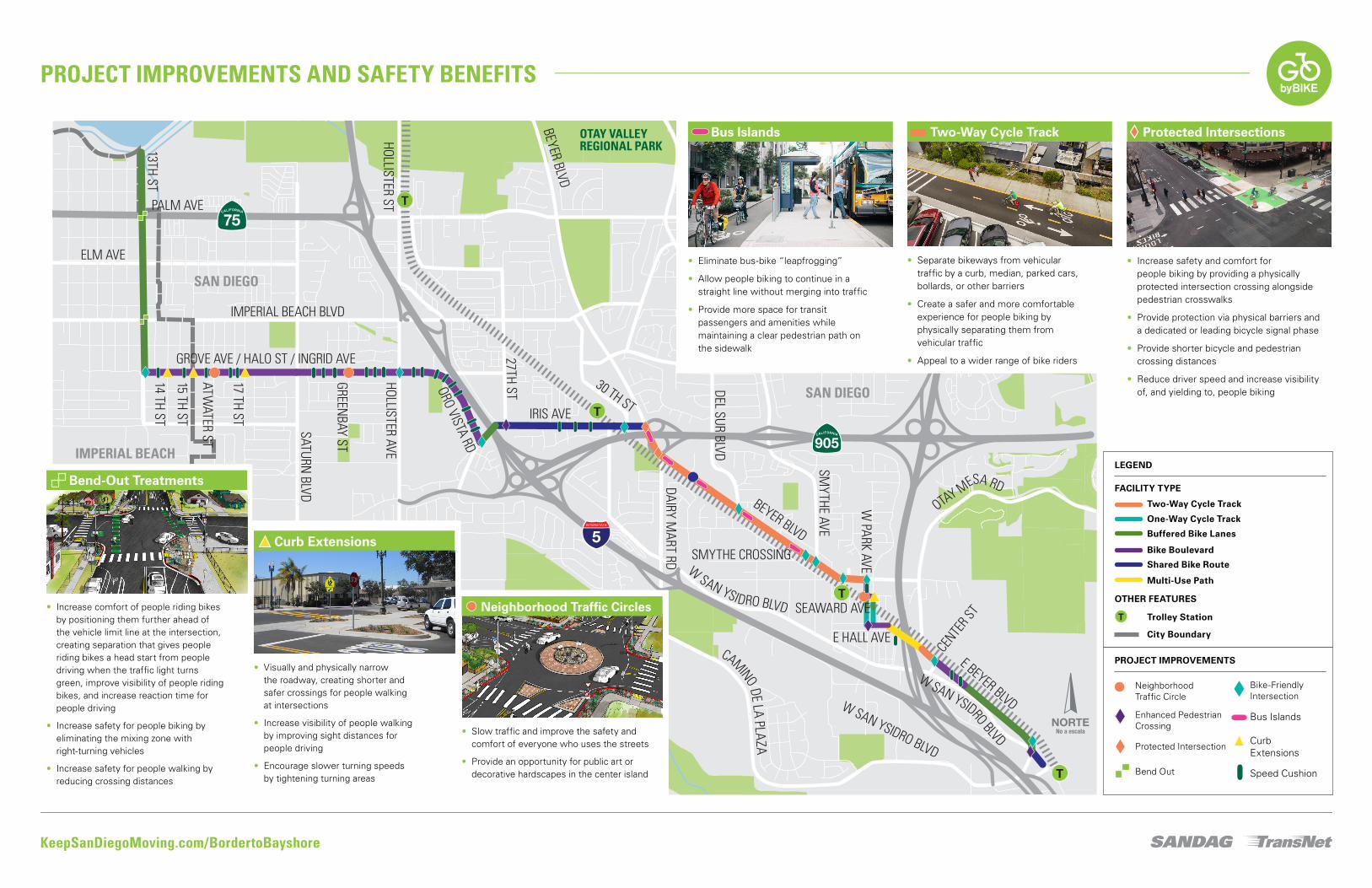
Project features include various bikeway facilities and treatments designed to make the streets safer and more comfortable for people who bike, walk, drive, and take transit. On busy streets, this generally means physically separating people biking from motor vehicle traffic. On quieter or residential streets, this involves the implementation of traffic calming features such as traffic circles and speed cushions.
BackgroundThe project will help fulfill the vision laid out in the San Diego Regional Bike Plan, which aims to make riding a bike a safer and more convenient choice for everyday travel. The Border to Bayshore Bikeway project is a vital part of the regional bike network, GO by BIKE, and a high-priority project funded through the Regional Bike Plan Early Action Program.
Extensive outreach was conducted for the project, with four community meetings held for community members to give input on route options between 2017 and 2018. To get involved or to learn more about the project, visit KeepSanDiegoMoving.com/BordertoBayshore.
DesignThe project improvements were strategically selected and designed to maximize safety for people riding bikes and walking. The following pages illustrate the project route and specific improvements – including descriptions, benefits, and images of key features. To sign up to receive project updates, visit KeepSanDiegoMoving.com/SubscribeGObyBIKE.
Border to Bayshore Bikeway
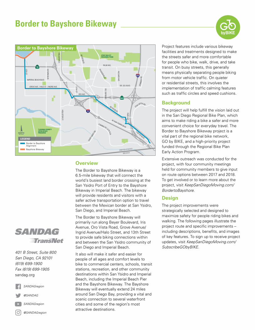
OverviewThe Border to Bayshore Bikeway is a 6.5-mile bikeway that will connect the world’s busiest land border crossing at the San Ysidro Port of Entry to the Bayshore Bikeway in Imperial Beach. The bikeway will provide residents and visitors with a safer active transportation option to travel between the Mexican border at San Ysidro, San Diego, and Imperial Beach.
The Border to Bayshore Bikeway will primarily run along Beyer Boulevard, Iris Avenue, Oro Vista Road, Grove Avenue/Ingrid Avenue/Halo Street, and 13th Street to provide safe biking connections within and between the San Ysidro community of San Diego and Imperial Beach.
It also will make it safer and easier for people of all ages and comfort levels to bike to commercial centers, schools, transit stations, recreation, and other community destinations within San Ysidro and Imperial Beach, including the Imperial Beach Pier and the Bayshore Bikeway. The Bayshore Bikeway will eventually extend 24 miles around San Diego Bay, providing a vital and scenic connection to several waterfront cities and some of the region’s most attractive destinations.
401 B Street, Suite 800 San Diego, CA 92101(619) 699-1900Fax (619) 699-1905sandag.org
ADDITIONAL BENEFITS
July 2020
Schedule • Preliminary Engineering
2015 – 2019
• Final Design 2019 – 2021
• Construction 2021 – 2024
Funding • The project is funded as
part of the $200 million Regional Bike Early Action Program funded by TransNet, the regional half-cent sales tax for transportation approved by voters countywide
• Additionally, the project was awarded funding from the state Active Transportation Program to help cover engineering, right of way, and construction costs
Sources:
1 page 25, “Protected Bike Lanes Mean Business”, bikewalkalliance.org 2 Pedestrian & Bicycle Infrastructure: A National Study of Employment Impacts
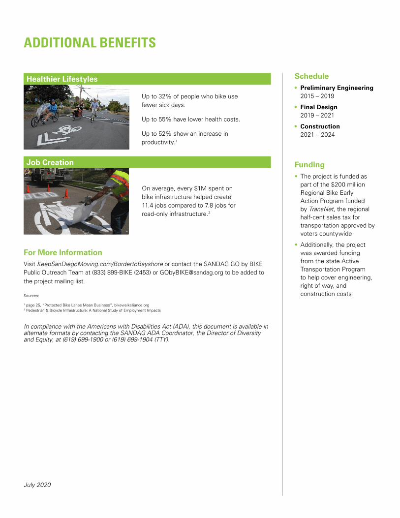
On average, every $1M spent on bike infrastructure helped create 11.4 jobs compared to 7.8 jobs for road-only infrastructure.2
Up to 32% of people who bike use fewer sick days.
Up to 55% have lower health costs.
Up to 52% show an increase in productivity.1
For More InformationVisit KeepSanDiegoMoving.com/BordertoBayshore or contact Project Manager, Alison Moss, at (619) 595-5354 or [email protected] to be added to the project mailing list.
In compliance with the Americans with Disabilities Act (ADA), this document is available in alternate formats by contacting the SANDAG ADA Coordinator, the Director of Diversity and Equity, at (619) 699-1900 or (619) 699-1904 (TTY).
Bus Islands Two-Way Cycle Track Protected Intersections
Curb Extensions
Neighborhood Traffic Circles
Bend-Out Treatments
PROJECT IMPROVEMENTS
Neighborhood Traffic Circle
Bus Islands
Curb Extensions
Enhanced Pedestrian Crossing
Protected Intersection
Bike-Friendly Intersection
Bend Out Speed Cushion
LEGEND
FACILITY TYPE
OTHER FEATURES
Trolley Station
Two-Way Cycle Track
One-Way Cycle Track
Buffered Bike Lanes
Bike Boulevard
Shared Bike Route
Multi-Use Path
City Boundary
• Increase comfort of people riding bikes by positioning them further ahead of the vehicle limit line at the intersection, creating separation that gives people riding bikes a head start from people driving when the traffic light turns green, improve visibility of people riding bikes, and increase reaction time for people driving
• Increase safety for people biking by eliminating the mixing zone with right-turning vehicles
• Increase safety for people walking by reducing crossing distances
• Eliminate bus-bike “leapfrogging”
• Allow people biking to continue in a straight line without merging into traffic
• Provide more space for transit passengers and amenities while maintaining a clear pedestrian path on the sidewalk
• Separate bikeways from vehicular traffic by a curb, median, parked cars, bollards, or other barriers
• Create a safer and more comfortable experience for people biking by physically separating them from vehicular traffic
• Appeal to a wider range of bike riders
• Increase safety and comfort for people biking by providing a physically protected intersection crossing alongside pedestrian crosswalks
• Provide protection via physical barriers and a dedicated or leading bicycle signal phase
• Provide shorter bicycle and pedestrian crossing distances
• Reduce driver speed and increase visibility of, and yielding to, people biking
• Visually and physically narrow the roadway, creating shorter and safer crossings for people walking at intersections
• Increase visibility of people walking by improving sight distances for people driving
• Encourage slower turning speeds by tightening turning areas
• Slow traffic and improve the safety and comfort of everyone who uses the streets
• Provide an opportunity for public art or decorative hardscapes in the center island
Project features include various bikeway facilities and treatments designed to make the streets safer and more comfortable for people who bike, walk, drive, and take transit. On busy streets, this generally means physically separating people biking from motor vehicle traffic. On quieter or residential streets, this involves the implementation of traffic calming features such as traffic circles and speed cushions.
BackgroundThe project will help fulfill the vision laid out in the San Diego Regional Bike Plan, which aims to make riding a bike a safer and more convenient choice for everyday travel. The Border to Bayshore Bikeway project is a vital part of the regional bike network, GO by BIKE, and a high-priority project funded through the Regional Bike Plan Early Action Program.
Extensive outreach was conducted for the project, with four community meetings held for community members to give input on route options between 2017 and 2018. To get involved or to learn more about the project, visit KeepSanDiegoMoving.com/BordertoBayshore.
DesignThe project improvements were strategically selected and designed to maximize safety for people riding bikes and walking. The following pages illustrate the project route and specific improvements – including descriptions, benefits, and images of key features. To sign up to receive project updates, visit KeepSanDiegoMoving.com/SubscribeGObyBIKE.
Border to Bayshore Bikeway
OverviewThe Border to Bayshore Bikeway is a 6.5-mile bikeway that will connect the world’s busiest land border crossing at the San Ysidro Port of Entry to the Bayshore Bikeway in Imperial Beach. The bikeway will provide residents and visitors with a safer active transportation option to travel between the Mexican border at San Ysidro, San Diego, and Imperial Beach.
The Border to Bayshore Bikeway will primarily run along Beyer Boulevard, Iris Avenue, Oro Vista Road, Grove Avenue/Ingrid Avenue/Halo Street, and 13th Street to provide safe biking connections within and between the San Ysidro community of San Diego and Imperial Beach.
It also will make it safer and easier for people of all ages and comfort levels to bike to commercial centers, schools, transit stations, recreation, and other community destinations within San Ysidro and Imperial Beach, including the Imperial Beach Pier and the Bayshore Bikeway. The Bayshore Bikeway will eventually extend 24 miles around San Diego Bay, providing a vital and scenic connection to several waterfront cities and some of the region’s most attractive destinations.
401 B Street, Suite 800 San Diego, CA 92101(619) 699-1900Fax (619) 699-1905sandag.org
ADDITIONAL BENEFITS
July 2020
Schedule • Preliminary Engineering
2015 – 2019
• Final Design2019 – 2021
• Construction2021 – 2024
Funding • The project is funded as
part of the $200 millionRegional Bike EarlyAction Program fundedby TransNet, the regionalhalf-cent sales tax fortransportation approved byvoters countywide
• Additionally, the projectwas awarded fundingfrom the state ActiveTransportation Programto help cover engineering,right of way, andconstruction costs
On average, every $1M spent on bike infrastructure helped create 11.4 jobs compared to 7.8 jobs for road-only infrastructure.2
Up to 32% of people who bike use fewer sick days.
Up to 55% have lower health costs.
Up to 52% show an increase in productivity.1
For More InformationVisit KeepSanDiegoMoving.com/BordertoBayshore or contact the SANDAG GO by BIKE Public Outreach Team at (833) 899-BIKE (2453) or [email protected] to be added to the project mailing list.
Sources:
1 page 25, “Protected Bike Lanes Mean Business”, bikewalkalliance.org 2 Pedestrian & Bicycle Infrastructure: A National Study of Employment Impacts
In compliance with the Americans with Disabilities Act (ADA), this document is available in alternate formats by contacting the SANDAG ADA Coordinator, the Director of Diversity and Equity, at (619) 699-1900 or (619) 699-1904 (TTY).