73 Additional Information on the Willow Creek Observatory, Northern California. John H. Rudolph, with contributions by Paul Middents ABSTRACT This paper provides additional infor- mation on an ancient observatory situated on the rim of Willow Creek Canyon in northeast California. Rudolf (1993, 1995, 1996) described the site and ob- served solar interactions. Two natural rock-roofed clefts in a basalt escarpment were utilized by placing various petro- glyphs on the walls so that shafts of light formed by modified natural cracks and rock configurations produced light point- ers that impinged upon specific parts of these petroglyphs at significant times of the year. The summer solstice is predict- ed by 59 days, i.e., two lunar cycles. The summer solstice is determined by a light pointer that lands on the sloping top of a standing stone at first sunlight. A light finger lands on the center mark of a sev- en-legged Super-Pi Petroglyph in the ear- ly afternoon. Only moonlight can reach the southernmost of the legs. Later, the sunlight lights only the top circle of the Sun/Moon Gage, the balance of the gage being illuminated only by moonlight, in- dicating knowledge of the 19-year lunar cycle. A computer program has been used to determine when the moon would be in a position to cast a beam of light on these two images. Near sunset, a light pointer moves around the outside line of concentric arcs to pull away at the top. At sunrise on the equinox, a light/shadow line runs exactly on the points of a stack of five chevrons. These and other inter- actions are dramatic indications that the site was used over a long period of time to mark the change of seasons with great accuracy, thus illustrating the importance of seasonal sky events to the early inhab- itants of the area INTRODUCTION The Willow Creek Observatory is on nor- therly end of a basalt ridge, which is heavily embellished with petroglyphs. Many are invisible unless sunlight slopes across the rock face tangentially. Two natural "caves", i.e., fissures in the basalt are covered partially by large slabs and boulders, and are of particular interest. One, the Sunrise Chamber opens to the Northeast. The other, the Sunset Cham- ber opens to the southwest. The main events observed and the principle sub- jects of this paper are: a sunrise light tri- angle on a now removed target stone, 59 day summer solstice predictor light spear, the equinox light/shadow line on chev- rons, and the late afternoon light-pointer on the Sunset Mask. Furthermore, the purpose and use of the mid-day light fin- ger on the Super-Pi Petroglyph, along with the meaning of the five wavy paral- lel lines and the purpose and use of the Sun/Moon Gage are described below. 1 DISCUSSION During the 1995 summer solstice visit, I observed and photographed a light point- er shaped like a clenched fist with ex- tended finger land on the Super-Pi Pet- roglyph with the tip of the finger first touching a drilled hole then moving to
Transcript
73
Additional Information on the Willow CreekObservatory, Northern California.
John H. Rudolph, with contributions by Paul Middents
ABSTRACT
This paper provides additional infor-mation on an ancient observatory situatedon the rim of Willow Creek Canyon innortheast California. Rudolf (1993,1995, 1996) described the site and ob-served solar interactions. Two naturalrock-roofed clefts in a basalt escarpmentwere utilized by placing various petro-glyphs on the walls so that shafts of lightformed by modified natural cracks androck configurations produced light point-ers that impinged upon specific parts ofthese petroglyphs at significant times ofthe year. The summer solstice is predict-ed by 59 days, i.e., two lunar cycles. Thesummer solstice is determined by a lightpointer that lands on the sloping top of astanding stone at first sunlight. A lightfinger lands on the center mark of a sev-en-legged Super-Pi Petroglyph in the ear-ly afternoon. Only moonlight can reachthe southernmost of the legs. Later, thesunlight lights only the top circle of theSun/Moon Gage, the balance of the gagebeing illuminated only by moonlight, in-dicating knowledge of the 19-year lunarcycle. A computer program has beenused to determine when the moon wouldbe in a position to cast a beam of light onthese two images. Near sunset, a lightpointer moves around the outside line ofconcentric arcs to pull away at the top.At sunrise on the equinox, a light/shadowline runs exactly on the points of a stackof five chevrons. These and other inter-actions are dramatic indications that thesite was used over a long period of time
to mark the change of seasons with greataccuracy, thus illustrating the importanceof seasonal sky events to the early inhab-itants of the area
INTRODUCTION
The Willow Creek Observatory is on nor-therly end of a basalt ridge, which isheavily embellished with petroglyphs.Many are invisible unless sunlight slopesacross the rock face tangentially. Twonatural "caves", i.e., fissures in the basaltare covered partially by large slabs andboulders, and are of particular interest.One, the Sunrise Chamber opens to theNortheast. The other, the Sunset Cham-ber opens to the southwest. The mainevents observed and the principle sub-jects of this paper are: a sunrise light tri-angle on a now removed target stone, 59day summer solstice predictor light spear,the equinox light/shadow line on chev-rons, and the late afternoon light-pointeron the Sunset Mask. Furthermore, thepurpose and use of the mid-day light fin-ger on the Super-Pi Petroglyph, alongwith the meaning of the five wavy paral-lel lines and the purpose and use of theSun/Moon Gage are described below.1
DISCUSSION
During the 1995 summer solstice visit, Iobserved and photographed a light point-er shaped like a clenched fist with ex-tended finger land on the Super-Pi Pet-roglyph with the tip of the finger firsttouching a drilled hole then moving to
74
the short center leg. (Rudolph 1995) Itthen moved off to the right (east). Thislight pointer never moved farther to thewest on the petroglyph, either before orafter the solstice. The only source oflight that would project the light finger toreach the westward three legs is moon-light. About 60 feet southwest of thesunrise chamber is another "cave" formedby a six foot wide fissure capped by largeslabs of rock creating a rough sort ofcave. The roof rock and an outer ledgeform a light pointer that lands on variouspetroglyphs at certain specific times ofthe year.
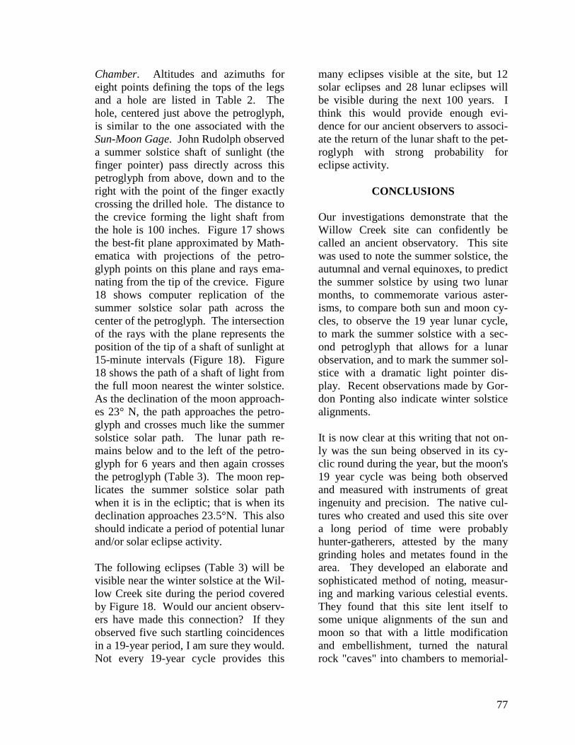
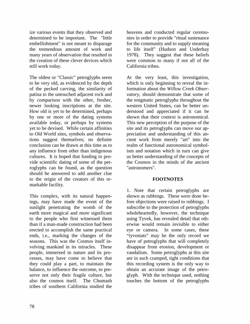
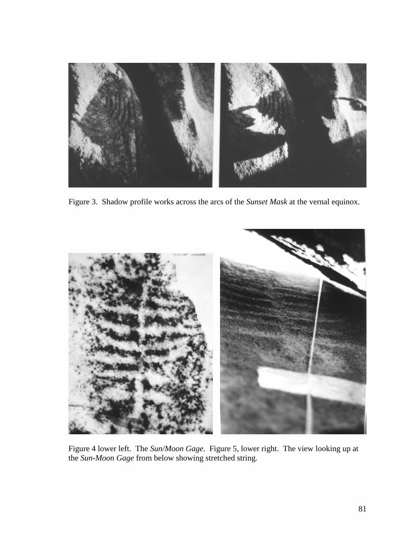
Figure 1 illustrates a section through thesunset chamber. From right to left thepetroglyphs are: the one-eyed SunsetMask, the parallel wavy lines, the double-lined serpentine, and the Sun/MoonGage. A light spear strikes the centerlobe of the double-lined serpentine, 59days before the summer solstice (Ru-dolph 1995). The light pointer moves upand around the Sunset Mask outer arc onthe afternoon of the summer solstice asshown in Figure 2. At the vernal equi-nox, this shadow profile works across thearcs of the Sunset Mask (Figure 3). TheSun/Moon Gage is shown in Figure 4.
The expedition of June17-23, 1996 wasundertaken to measure azimuth and alti-tude angles of assumed sun and moonlight pointers that I postulated would im-pinge upon the Sun-Moon Gage. Thesewere taken by first stretching a stringfrom aperture to petroglyph with the helpof Dr. Bob Fortner and then measuringmore accurately with an optical K&E"mountain transit", actually a theodolite.The sunlight, shaped by the narrow aper-ture, was observed to fully illuminate theupper offset circled dot only at its maxi-mum.
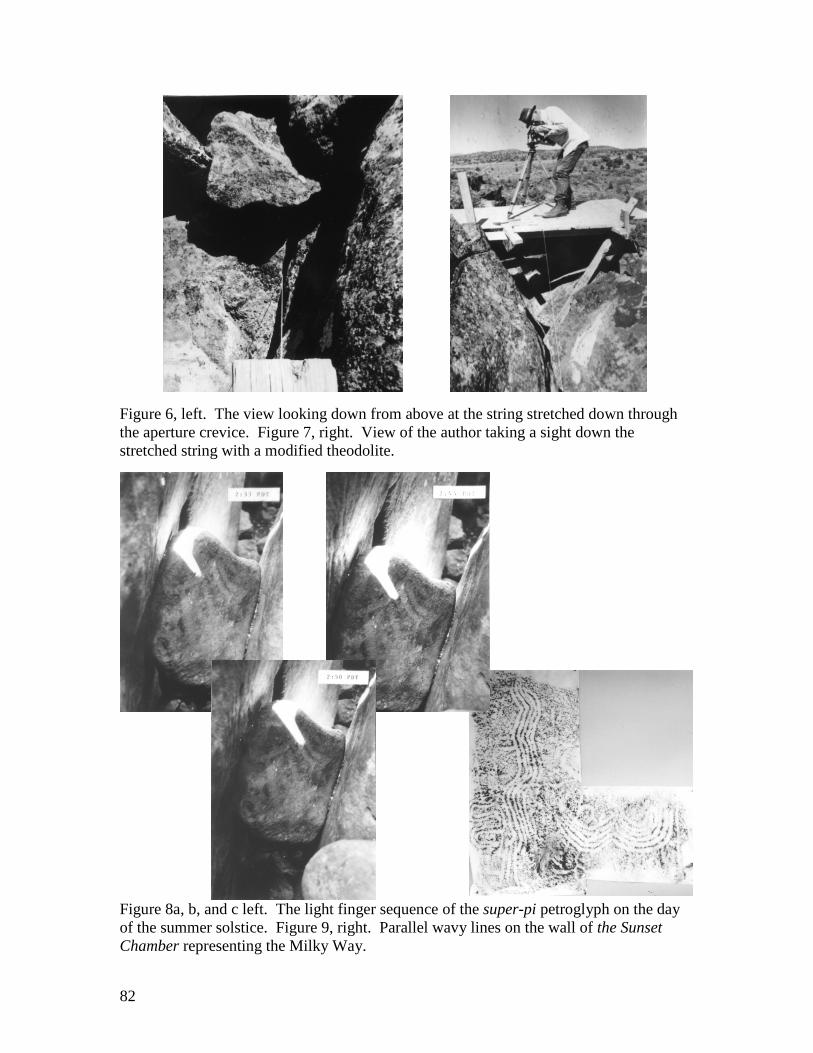
Figure 5 shows the view looking up at theSun-Moon Gage from below showingstretched string. The view looking downfrom above at the string stretched downthrough the aperture crevice is shown inFigure 6. Figure 7 is the view of theauthor taking a sight down the stretchedstring with a modified theodolite. Thisrather crude method gave remarkablyaccurate results and was used by PaulMiddents (1966). The analysis workedup by Middents gave tantalizing "proof"that the hypothesis was correct, namely,that this was indeed a gage to comparethe angles of elevation of the moonthroughout its nineteen year cycle to thatof the sun at its maximum elevation at thesummer solstice.
Because these angles were measured withstretched string and a crude sighting de-vice, I determined to return to the sitewith Paul Middents, equipped with a bet-ter instrument later that year. I modifiedthe theodolite by mounting an inexpen-sive telescopic rifle sight atop the tele-scope barrel of the instrument. Offsettingthis sight above the barrel of the instru-ment allowed vertical angles to be meas-ured up to 75 degrees. We visited the siteon September 5-9, 1996 and spent mostof our time making careful measurementsof azimuth and altitude of both the Sun-Moon Gage in the Sunset Chamber, andalso the angles of sun and moonlightpointers at the Super-Pi Petroglyph in theSunrise Chamber.
Figure 8 a, b, and c show the light fingersequence of the Super-Pi Petroglyph onthe day of the summer solstice. We nowhad careful and accurate measurements atthe Sun-Moon Gage and the Super-PiPetroglyph so Paul Middents could do ananalysis of both. The last part of this pa-
75
per will be an abridged version of theseanalyses.
One fascinating "revelation" is worthnoting before proceeding with Paul's partof the work. The parallel wavy lines inthe Sunset Chamber had been an enigmato me. It looked as though it representeda river or a stream, but in this astronomiccontext, I thought that this mightrepresent the Milky Way, the "river" ofstars in the sky. This sort of wavy linepetroglyph is found at sites elsewhere inthe west, and is the sign for water inEgyptian hieroglyphs. But there was noproof. One especially puzzling aspectwas that the right-hand line crossed overthe other four and ended in a pecked holein the rock face.
We were sleeping out under the brilliantstars on this trip, and I woke from asound sleep to be perfectly awake, just asthough someone had called my name.Without moving my head or eyes, I waslooking at that part of the Milky Way thatholds the constellation Perseus. I waslooking at a great raveled rope of starsthat led from the "right" side of the MilkyWay across it in a great curve that leddirectly to the brilliant cluster of thePleiades. This observation is, of course,subjective, but I offer it as a strongindication that the parallel wavy lines onthe wall of the Sunset Chamber doesindeed represent the Milky Way (Figure9). The double-lined serpentine is inroughly the correct position to representCassiopeia. This suggests that one eye ofthe Sunset Mask represents Polaris.
AN ANALYSIS OF TWO PETRO-GLYPHS AT THE WILLOW CREEK
SITE BY PAUL MIDDENTS
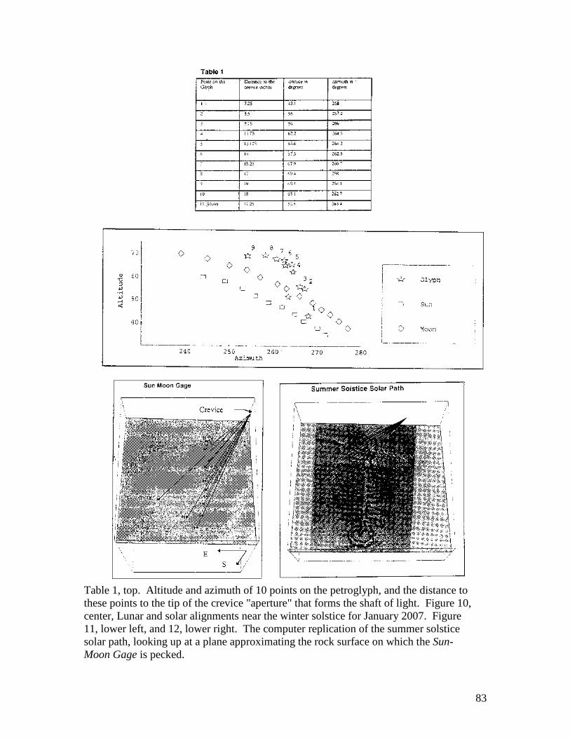
A set of data describing the alignment ofthe Sun-Moon Gage petroglyph has beenanalyzed for possible coincidences withcelestial positions of the sun and themoon. On the summer solstice a shaft ofsunlight was observed by John Rudolphto cross the upper three-inch diametercircle only. Middents and Rudolph'smeasurements of azimuth and altitudeconfirms the sunlight position at thesummer solstice and supports a strongassociation between this petroglyph andthe full moon on either side of the wintersolstice. The alignments are such that thepetroglyph is touched by a shaft of moon-light only at the full moon's nearest thewinter solstice during about fifteen yearsof the nineteen-year lunar cycle.
The petroglyph seems to be recording thechange in the lunar path as the lunar (Sa-ros) cycle progresses. The data (Table 1)consists of the altitude and azimuth of 10points on the petroglyph and the distanceto these points to the tip of the crevice"aperture" that forms the shaft of light.The 11th point is a deep, 1/4" diameterhole located to the left of the petroglyph.Full moon declinations near the wintersolstice range from about 18° N to 28° Nduring the 19-year lunar cycle. This pro-duces meridinal transit altitudes from 67°to 78° at the latitude of the Sunset Cham-ber (40.4° N). The Lunar declinationmust be at least 23° N to produce a pathacross the sky of sufficient altitude toalign with the crevice and the topmostpart of the petroglyph.
The analysis was conducted using theplanetarium software, "Dance of thePlanets". Promising lunar alignments
76
near the winter solstice in the years 2005,2006 and 2007 were analyzed first. Thecalculated paths were plotted using"Mathematica", a computer algebra fig-ure. The results for January 2007 are il-lustrated in Figure10. This figure con-firms that the sun produces a path of lightthat crosses the upper part of the petro-glyph each year. The lunar path appearsto cross the petroglyph several inches be-low the top (#9). However, no indicationof how closely the shaft of moonlightmight pass to the rest of the petroglyphcan be gleaned from this plot.
A three dimensional analysis was con-ducted next. Figure 10 shows a planarsurface calculated and plotted by Mathe-matica, which is a best fit to the elevenmeasured points on the petroglyph. Theplotted points are projections on the best-fit plane of the actual points. The actualpoints all lie within one inch of the best-fit plane so the computer provides a rea-sonable approximation of the rock sur-face on which the petroglyph is pecked.This surface bulges out slightly near thecenter of the petroglyph and runs almostdue east and west (Figure 10). In Figure10 the star symbols are the first ninepoints on the petroglyph from Table 1.The diamond symbols show the fullmoon nearest the winter solstice in 2006crossing the petroglyph several inchesbelow the top. The triangle symbolsshow the sun crossing the top of the pet-roglyph near the summer solstice. Figure11 is looking up at a plane approximatingthe rock surface on which the Sun-MoonGage is pecked. Ten points on the petro-glyph are shown together with rays ema-nating from the tip of the crevice, whichforms a shaft of sunlight or moonlight.The leftmost point (#11) is a 2" deep,1/4" diameter hole. Figure 12 shows thecomputer replication of the summer sol-
stice solar path observed by John Ru-dolph. In Figures 11 and 12 the pointwhere each ray intersects the plane repre-sents the predicted path of the right handtip of the light shaft generated by sun ormoon light passing through the crevice.Each ray represents the position of tip ofthe light shaft at 15-minute intervals.The paths pictured would take from twoto three hours to complete and wouldprogress from bottom to top and left toright.
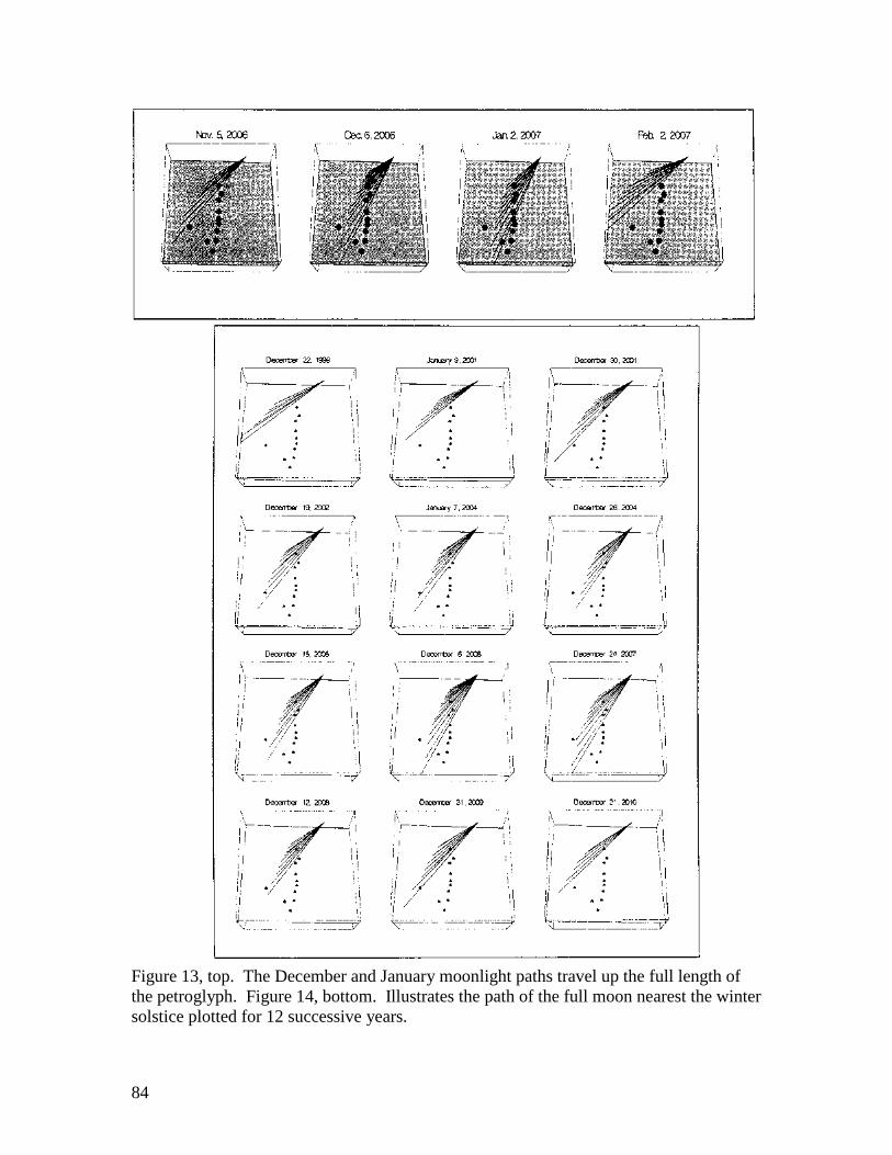
The December and January moonlightpaths travel up the full length of the pet-roglyph (Figure 13). Figure 14 illustratesthe path of the full moon nearest the win-ter solstice plotted for 12 successiveyears. The variation in lunar path is dueto the changing declination (altitude) ofthe moon from year to year. The patternrepeats every 19 years. At the point ofthe lunar cycle when the lunar declinationapproaches 23° N in 1999 a path similarto the summer solstice solar path results.Each successive year the path starts loweron the petroglyph and proceeds upwardtoward the top. The moon reaches amaximum declination of about 28° N in2006 and from that time on, the pathstarts higher up on the petroglyph until itno longer strikes the petroglyph at all.The winter solstice moonlight shaft willnot strike the petroglyph again until 2019when the entire cycle repeats.
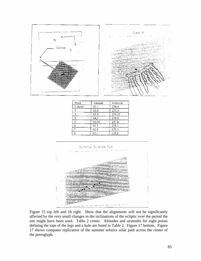
No attempt has been made to analyze lu-nar positions in the distant past. Thealignments will not be significantly af-fected by the very small changes in theinclinations of the ecliptic over the periodthe site might have been used (Figure 15and 16).
A similar analysis has been applied to theSuper-Pi Petroglyph in the Sunrise
77
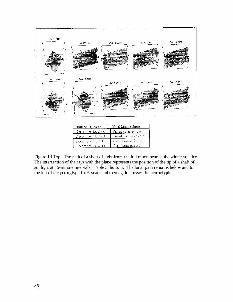
Chamber. Altitudes and azimuths foreight points defining the tops of the legsand a hole are listed in Table 2. Thehole, centered just above the petroglyph,is similar to the one associated with theSun-Moon Gage. John Rudolph observeda summer solstice shaft of sunlight (thefinger pointer) pass directly across thispetroglyph from above, down and to theright with the point of the finger exactlycrossing the drilled hole. The distance tothe crevice forming the light shaft fromthe hole is 100 inches. Figure 17 showsthe best-fit plane approximated by Math-ematica with projections of the petro-glyph points on this plane and rays ema-nating from the tip of the crevice. Figure18 shows computer replication of thesummer solstice solar path across thecenter of the petroglyph. The intersectionof the rays with the plane represents theposition of the tip of a shaft of sunlight at15-minute intervals (Figure 18). Figure18 shows the path of a shaft of light fromthe full moon nearest the winter solstice.As the declination of the moon approach-es 23° N, the path approaches the petro-glyph and crosses much like the summersolstice solar path. The lunar path re-mains below and to the left of the petro-glyph for 6 years and then again crossesthe petroglyph (Table 3). The moon rep-licates the summer solstice solar pathwhen it is in the ecliptic; that is when itsdeclination approaches 23.5°N. This alsoshould indicate a period of potential lunarand/or solar eclipse activity.
The following eclipses (Table 3) will bevisible near the winter solstice at the Wil-low Creek site during the period coveredby Figure 18. Would our ancient observ-ers have made this connection? If theyobserved five such startling coincidencesin a 19-year period, I am sure they would.Not every 19-year cycle provides this
many eclipses visible at the site, but 12solar eclipses and 28 lunar eclipses willbe visible during the next 100 years. Ithink this would provide enough evi-dence for our ancient observers to associ-ate the return of the lunar shaft to the pet-roglyph with strong probability foreclipse activity.
CONCLUSIONS
Our investigations demonstrate that theWillow Creek site can confidently becalled an ancient observatory. This sitewas used to note the summer solstice, theautumnal and vernal equinoxes, to predictthe summer solstice by using two lunarmonths, to commemorate various aster-isms, to compare both sun and moon cy-cles, to observe the 19 year lunar cycle,to mark the summer solstice with a sec-ond petroglyph that allows for a lunarobservation, and to mark the summer sol-stice with a dramatic light pointer dis-play. Recent observations made by Gor-don Ponting also indicate winter solsticealignments.
It is now clear at this writing that not on-ly was the sun being observed in its cy-clic round during the year, but the moon's19 year cycle was being both observedand measured with instruments of greatingenuity and precision. The native cul-tures who created and used this site overa long period of time were probablyhunter-gatherers, attested by the manygrinding holes and metates found in thearea. They developed an elaborate andsophisticated method of noting, measur-ing and marking various celestial events.They found that this site lent itself tosome unique alignments of the sun andmoon so that with a little modificationand embellishment, turned the naturalrock "caves" into chambers to memorial-
78
ize various events that they observed anddetermined to be important. The "littleembellishment" is not meant to disparagethe tremendous amount of work andmany years of observation that resulted inthe creation of these clever devices whichstill work today.
The oldest or "Classic" petroglyphs seemto be very old, as evidenced by the depthof the pecked carving, the similarity ofpatina to the untouched adjacent rock andby comparison with the other, fresher,newer looking inscriptions at the site.How old is yet to be determined, perhapsby one or more of the dating systemsavailable today, or perhaps by systemsyet to be devised. While certain affinitiesto Old World sites, symbols and observa-tions suggest themselves; no definiteconclusion can be drawn at this time as toany influence from other than indigenouscultures. It is hoped that funding to pro-vide scientific dating of some of the pet-roglyphs can be found, as the questionshould be answered to add another clueto the origin of the creators of this re-markable facility.
This complex, with its natural happen-ings, may have made the event of thesunlight penetrating the womb of theearth more magical and more significantto the people who first witnessed themthan if a man-made construction had beenerected to accomplish the same practicalends, i.e., marking the changes of theseasons. This was the Cosmos itself in-volving mankind in its miracles. Thesepeople, immersed in nature and its pro-cesses, may have come to believe thatthey could play a part, to maintain thebalance, to influence the outcome, to pre-serve not only their fragile culture, butalso the cosmos itself. The Chumashtribes of southern California studied the
heavens and conducted regular ceremo-nies in order to provide "ritual sustenancefor the community and to supply meaningto life itself" (Hudson and Underhay1978). They suggest that these beliefswere common to many if not all of theCalifornia tribes.
At the very least, this investigation,which is only beginning to reveal the in-formation about the Willow Creek Obser-vatory, should demonstrate that some ofthe enigmatic petroglyphs throughout thewestern United States, can be better un-derstood and appreciated if it can beshown that their context is astronomical.This new perception of the purpose of thesite and its petroglyphs can move our ap-preciation and understanding of this an-cient work from merely "art" into therealm of functional astronomical symbol-ism and notation which in turn can giveus better understanding of the concepts ofthe Cosmos in the minds of the ancient"astronomers".
FOOTNOTES
1. Note that certain petroglyphs areshown as rubbings. These were done be-fore objections were raised to rubbings. Isubscribe to the protection of petroglyphswholeheartedly, however, the techniqueusing Tyvek, has revealed detail that oth-erwise would remain invisible to eithereye or camera. In some cases, these“tyvostats” may be the only record wehave of petroglyphs that will completelydisappear from erosion, development orvandalism. Some petroglyphs at this siteare in such cramped, tight conditions thatthis recording system is the only way toobtain an accurate image of the petro-glyph. With the technique used, nothingtouches the bottom of the petroglyphs
79
themselves; thus there is no impact tofuture dating efforts.
ACKNOWLEDGMENTS
I wish to acknowledge my debt to Robertand Francis Connick who introduced meto the site and who have produced severalexcellent papers about it. Also, Nal Mor-ris and Rollin Gillespie for their help,support and encouragement since beingpart of the expedition of 1992. Dr. Rob-ert Fortner, who helped immeasurably ontwo solstice trips, 1995 and 1996. PaulMiddents, co-author of this paper, whoshared the "hardships" of the 1996 expe-dition and whose help in measuring azi-muths and altitudes together with hisskills in analysis of the data has givenconfirmation of the hypothesis that theSun-Moon Gage and the Super Pi Petro-glyph are indeed devices to measure andcompare various positions of the sun andmoon during the moon's 19 year cycle.Thanks also to the Battle Point Astro-nomical Association for its moral supportand encouragement. I also thank the Ox-ford V organization for allowing me topresent an earlier version of this paper attheir conference in Santa Fe, New Mexi-co in 1996. Special appreciation to DonGilmore and the New England Antiqui-ties Association who helped make thefirst presentation of this site at theNEARA America Before Columbus Con-ference at Brown University in 1992 andsubsequent publication possible.
BIBLIOGRAPHY
Hudson, Travis and Ernest Underhay1978 Crystals in the Sky: An
Intellectual Odyssey involvingChumash Astronomy, Cosmologyand Rock Art. Ballena Press,Ramona, California.
Middents, Paul1966 Preliminary computer analysis of
Willow Creek Canyon Archaeoastro-nomy Site. Presented together with aposter display at the Oxford Vconference on Cultural Aspects ofAstronomy in Santa Fe, NewMexico, August 3-9.
Rudolph, John H.1996 Poster display. Fifth Annual
Conference on Archaeoastronomy,August 3-9, Santa Fe, New Mexico.
1995 Willow Creek Observatory, AnAncient Solar Observatory at WillowCreek, California. Utah Rock Art,Volume 13. Salt Lake City, Utah.
1992 America before Columbus. NewEngland Antiquities ResearchAssociation Conference, BrownUniversity.
80
FIGURES
Figure 1. A section through the sunset chamber.
Figure 2. The light pointer moving up and around the Sunset Mask outer arc on theafternoon of the summer solstice.
81
Figure 3. Shadow profile works across the arcs of the Sunset Mask at the vernal equinox.
Figure 4 lower left. The Sun/Moon Gage. Figure 5, lower right. The view looking up atthe Sun-Moon Gage from below showing stretched string.
82
Figure 6, left. The view looking down from above at the string stretched down throughthe aperture crevice. Figure 7, right. View of the author taking a sight down thestretched string with a modified theodolite.
Figure 8a, b, and c left. The light finger sequence of the super-pi petroglyph on the dayof the summer solstice. Figure 9, right. Parallel wavy lines on the wall of the SunsetChamber representing the Milky Way.
83
Table 1, top. Altitude and azimuth of 10 points on the petroglyph, and the distance tothese points to the tip of the crevice "aperture" that forms the shaft of light. Figure 10,center, Lunar and solar alignments near the winter solstice for January 2007. Figure11, lower left, and 12, lower right. The computer replication of the summer solsticesolar path, looking up at a plane approximating the rock surface on which the Sun-Moon Gage is pecked.
84
Figure 13, top. The December and January moonlight paths travel up the full length ofthe petroglyph. Figure 14, bottom. Illustrates the path of the full moon nearest the wintersolstice plotted for 12 successive years.
85
Figure 15 top left and 16 right. Show that the alignments will not be significantlyaffected by the very small changes in the inclinations of the ecliptic over the period thesite might have been used. Table 2 center. Altitudes and azimuths for eight pointsdefining the tops of the legs and a hole are listed in Table 2. Figure 17 bottom. Figure17 shows computer replication of the summer solstice solar path across the center ofthe petroglyph.
86
Figure 18 Top. The path of a shaft of light from the full moon nearest the winter solstice.The intersection of the rays with the plane represents the position of the tip of a shaft ofsunlight at 15-minute intervals. Table 3, bottom. The lunar path remains below and tothe left of the petroglyph for 6 years and then again crosses the petroglyph.