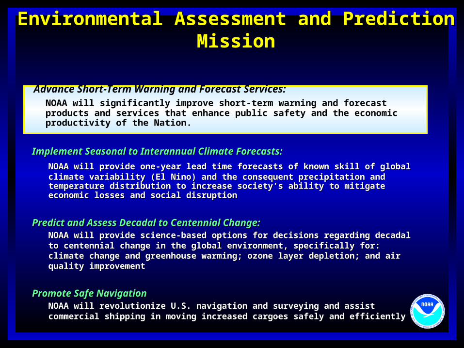
Environmental Assessment and Prediction MissionEnvironmental Assessment and Prediction Mission
Implement Seasonal to Interannual Climate Forecasts:Implement Seasonal to Interannual Climate Forecasts:
NOAA will provide one-year lead time forecasts of known skill of global climate NOAA will provide one-year lead time forecasts of known skill of global climate variability (El Nino) and the consequent precipitation and temperature distribution to variability (El Nino) and the consequent precipitation and temperature distribution to increase society’s ability to mitigate economic losses and social disruptionincrease society’s ability to mitigate economic losses and social disruption
Predict and Assess Decadal to Centennial Change:Predict and Assess Decadal to Centennial Change:NOAA will provide science-based options for decisions regarding decadal to NOAA will provide science-based options for decisions regarding decadal to centennial change in the global environment, specifically for: climate change and centennial change in the global environment, specifically for: climate change and greenhouse warming; ozone layer depletion; and air quality improvementgreenhouse warming; ozone layer depletion; and air quality improvement
Promote Safe NavigationPromote Safe NavigationNOAA will revolutionize U.S. navigation and surveying and assist commercial NOAA will revolutionize U.S. navigation and surveying and assist commercial shipping in moving increased cargoes safely and efficientlyshipping in moving increased cargoes safely and efficiently
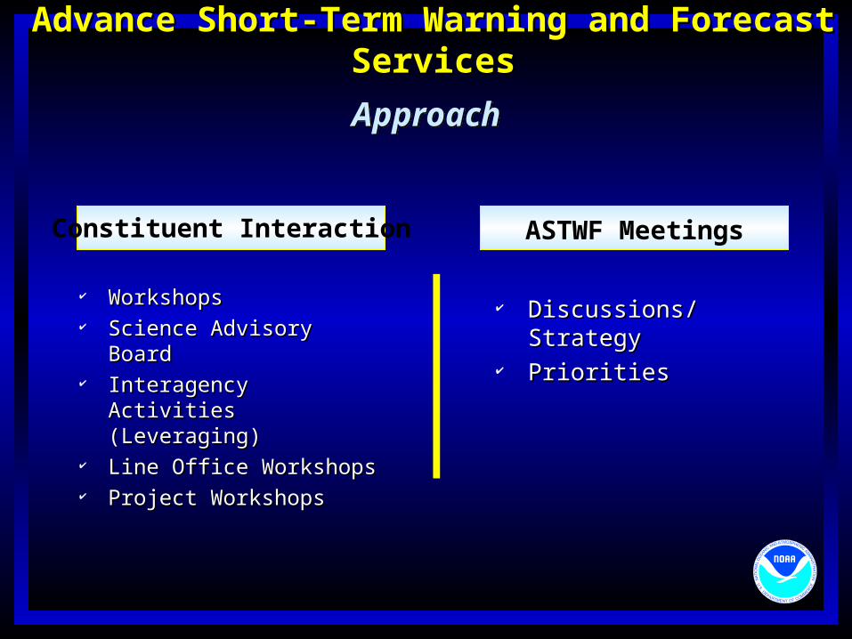
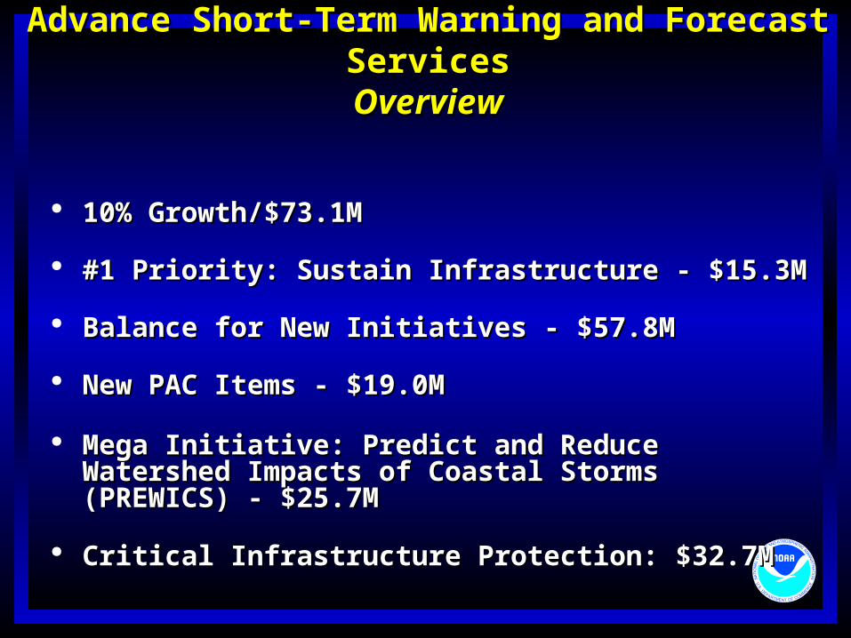
Advance Short-Term Warning and Forecast Services:NOAA will significantly improve short-term warning and forecast products and services that enhance public safety and the economic productivity of the Nation.
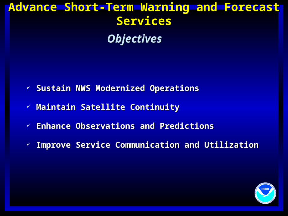
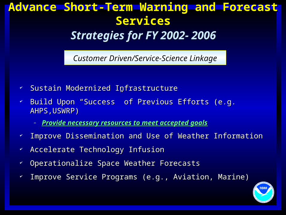
Advance Short-Term Warning and Forecast ServicesAdvance Short-Term Warning and Forecast Services
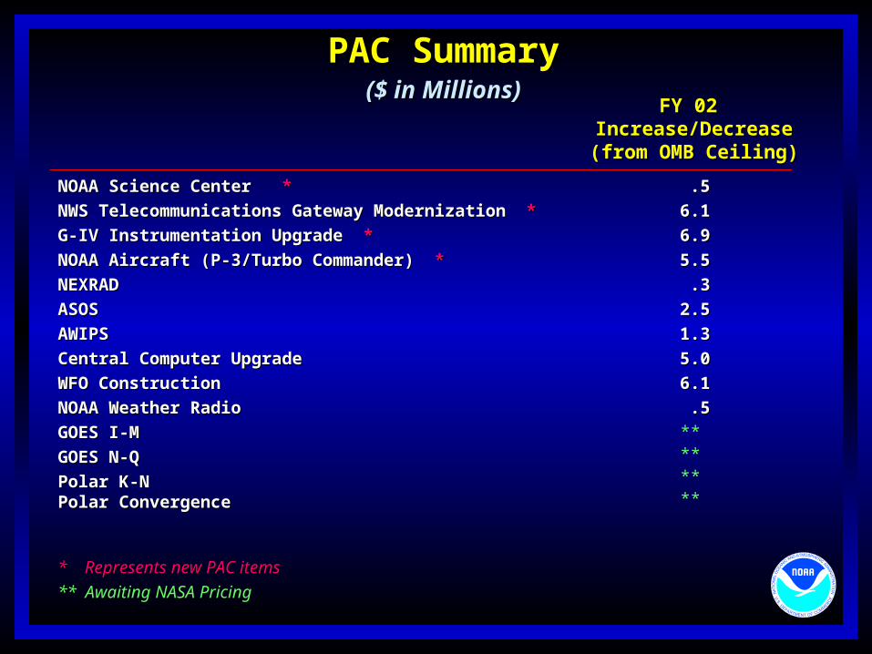
Balance for New Initiatives - $57.8MBalance for New Initiatives - $57.8M
New PAC Items - $19.0MNew PAC Items - $19.0M
Mega Initiative: Predict and Reduce Watershed Mega Initiative: Predict and Reduce Watershed Impacts of Coastal Storms (PREWICS) - $25.7MImpacts of Coastal Storms (PREWICS) - $25.7M
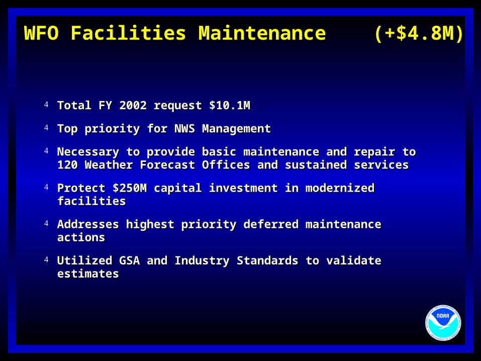
Total FY 2002 request $10.1MTotal FY 2002 request $10.1M
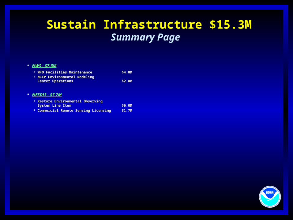
Top priority for NWS ManagementTop priority for NWS Management
Necessary to provide basic maintenance and repair to 120 Necessary to provide basic maintenance and repair to 120 Weather Forecast Offices and sustained servicesWeather Forecast Offices and sustained services
Protect $250M capital investment in modernized facilitiesProtect $250M capital investment in modernized facilities
Utilized GSA and Industry Standards to validate estimatesUtilized GSA and Industry Standards to validate estimates
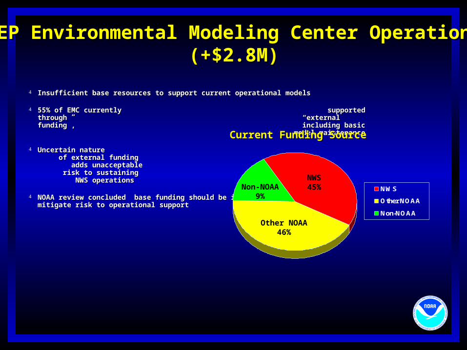
NCEP Environmental Modeling Center Operations NCEP Environmental Modeling Center Operations (+$2.8M)(+$2.8M)
Insufficient base resources to support current operational modelsInsufficient base resources to support current operational models
55% of EMC currently supported through 55% of EMC currently supported through “external funding”, “external funding”, including basic model maintenanceincluding basic model maintenance
Uncertain nature of external funding Uncertain nature of external funding adds unacceptable adds unacceptable risk to sustaining NWS operations risk to sustaining NWS operations
NOAA review concluded base funding should be increased from 45% to 75% to NOAA review concluded base funding should be increased from 45% to 75% to mitigate risk to operational supportmitigate risk to operational support
Impact of not restoring fundingImpact of not restoring funding Increased risk to spacecraft data, health, and safetyIncreased risk to spacecraft data, health, and safety
Extended outages and degraded performanceExtended outages and degraded performance
Freeze in current product technology; delays in delivery of Freeze in current product technology; delays in delivery of new satellite products to forecast officesnew satellite products to forecast offices
NWS forecast improvements will stagnate without benefits of NWS forecast improvements will stagnate without benefits of satellite datasatellite data
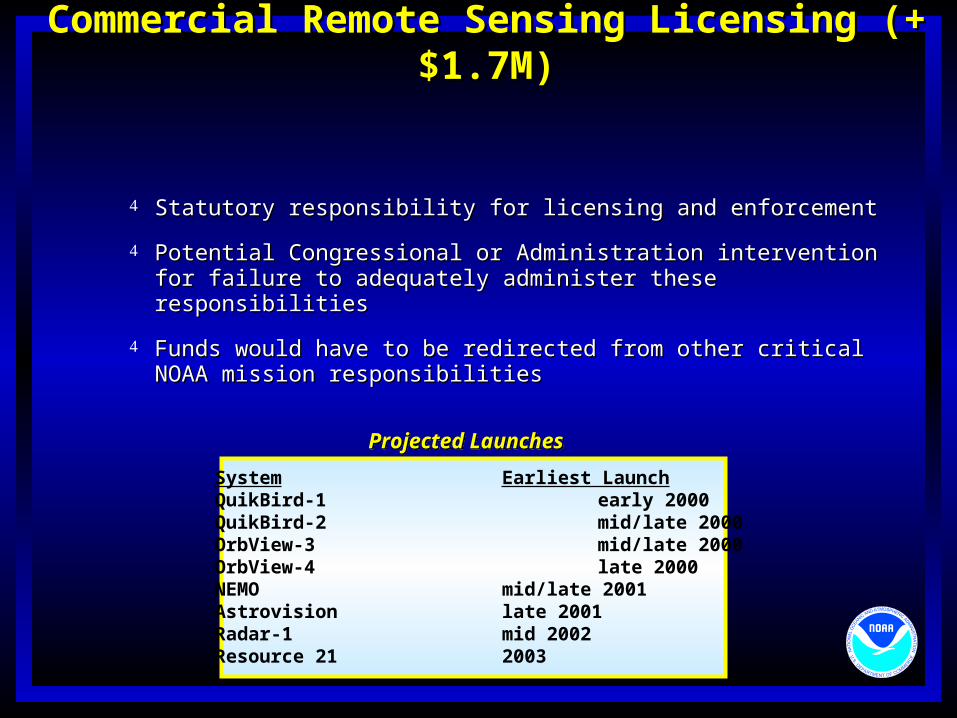
Statutory responsibility for licensing and enforcementStatutory responsibility for licensing and enforcement
Potential Congressional or Administration intervention for Potential Congressional or Administration intervention for failure to adequately administer these responsibilitiesfailure to adequately administer these responsibilities
Funds would have to be redirected from other critical NOAA Funds would have to be redirected from other critical NOAA mission responsibilitiesmission responsibilities
Projected LaunchesProjected Launches
System Earliest LaunchQuikBird-1 early 2000QuikBird-2 mid/late 2000OrbView-3 mid/late 2000OrbView-4 late 2000NEMO mid/late 2001Astrovision late 2001Radar-1 mid 2002Resource 21 2003
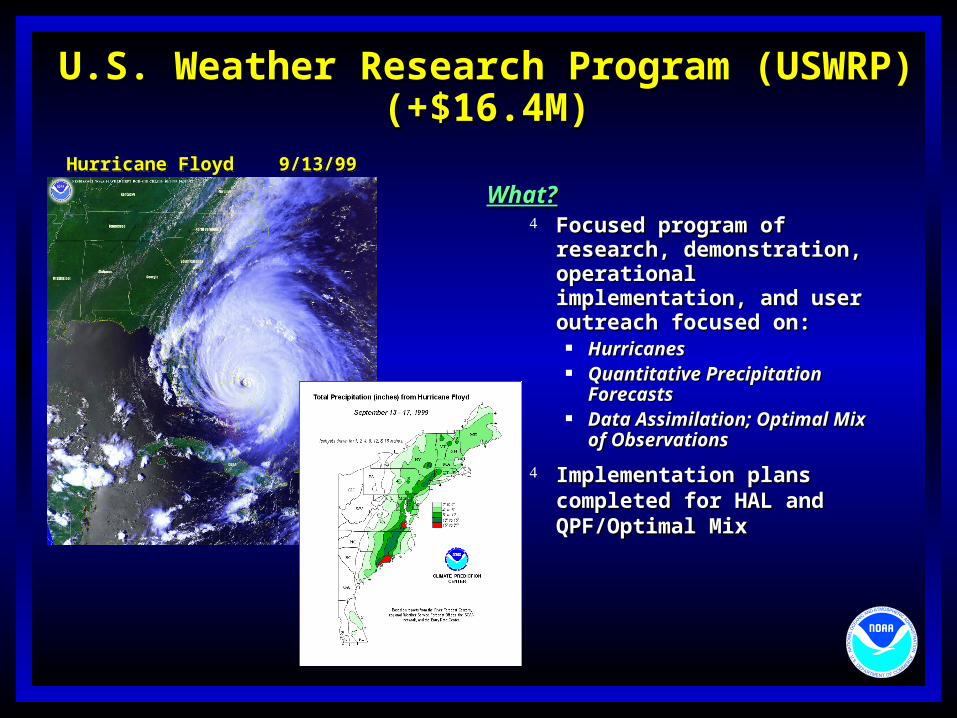
U.S. Weather Research Program (USWRP)U.S. Weather Research Program (USWRP)(+$16.4M)(+$16.4M)
What?What? Focused program of research, Focused program of research,
demonstration, operational demonstration, operational implementation, and user implementation, and user outreach focused on:outreach focused on:
ForecastsForecasts Data Assimilation; Optimal Mix Data Assimilation; Optimal Mix
of Observationsof Observations
Implementation plans Implementation plans completed for HAL and completed for HAL and QPF/Optimal MixQPF/Optimal Mix
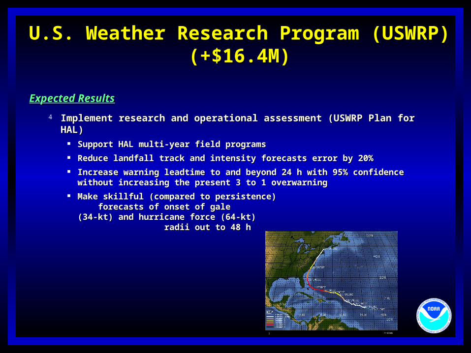
Hurricane Floyd 9/13/99Hurricane Floyd 9/13/99
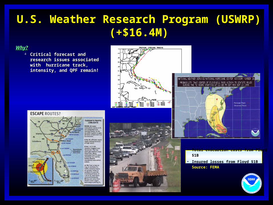
U.S. Weather Research Program (USWRP)U.S. Weather Research Program (USWRP)(+$16.4M)(+$16.4M)
Why?Why? Critical forecast and research Critical forecast and research
issues associated with hurricane issues associated with hurricane track, intensity, and QPF remain!track, intensity, and QPF remain!
• Total evacuation costs from Floyd $1B
• Insured losses from Floyd $1B
Source: FEMA
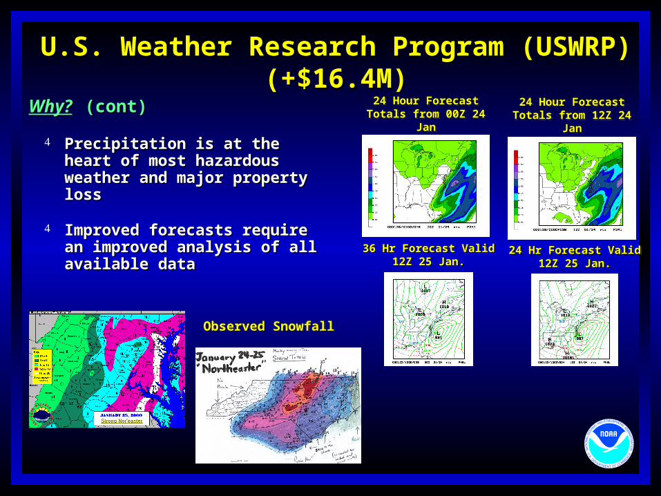
U.S. Weather Research Program (USWRP)U.S. Weather Research Program (USWRP)(+$16.4M)(+$16.4M)
Why?Why? (cont)(cont)
Precipitation is at the heart of Precipitation is at the heart of most hazardous weather and most hazardous weather and major property lossmajor property loss
Improved forecasts require an Improved forecasts require an improved analysis of all improved analysis of all available dataavailable data
Observed SnowfallObserved Snowfall
24 Hour Forecast Totals from 12Z 24 Jan
24 Hour Forecast Totals from 12Z 24 Jan
24 Hr Forecast Valid12Z 25 Jan.
24 Hr Forecast Valid12Z 25 Jan.
24 Hour Forecast Totals from 00Z 24 Jan
24 Hour Forecast Totals from 00Z 24 Jan
36 Hr Forecast Valid12Z 25 Jan.
36 Hr Forecast Valid12Z 25 Jan.
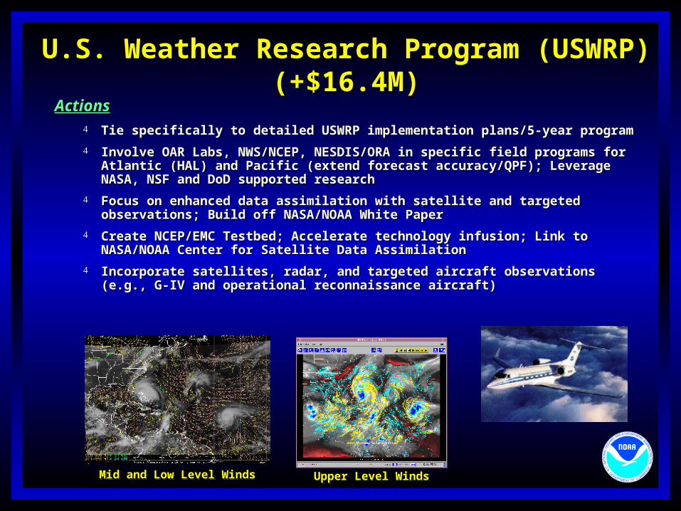
U.S. Weather Research Program (USWRP)U.S. Weather Research Program (USWRP)(+$16.4M)(+$16.4M)
ActionsActions Tie specifically to detailed USWRP implementation plans/5-year programTie specifically to detailed USWRP implementation plans/5-year program
Involve OAR Labs, NWS/NCEP, NESDIS/ORA in specific field programs for Atlantic Involve OAR Labs, NWS/NCEP, NESDIS/ORA in specific field programs for Atlantic (HAL) and Pacific (extend forecast accuracy/QPF); Leverage NASA, NSF and DoD (HAL) and Pacific (extend forecast accuracy/QPF); Leverage NASA, NSF and DoD supported researchsupported research
Focus on enhanced data assimilation with satellite and targeted observations; Focus on enhanced data assimilation with satellite and targeted observations; Build off NASA/NOAA White PaperBuild off NASA/NOAA White Paper
Create NCEP/EMC Testbed; Accelerate technology infusion; Link to NASA/NOAA Create NCEP/EMC Testbed; Accelerate technology infusion; Link to NASA/NOAA Center for Satellite Data AssimilationCenter for Satellite Data Assimilation
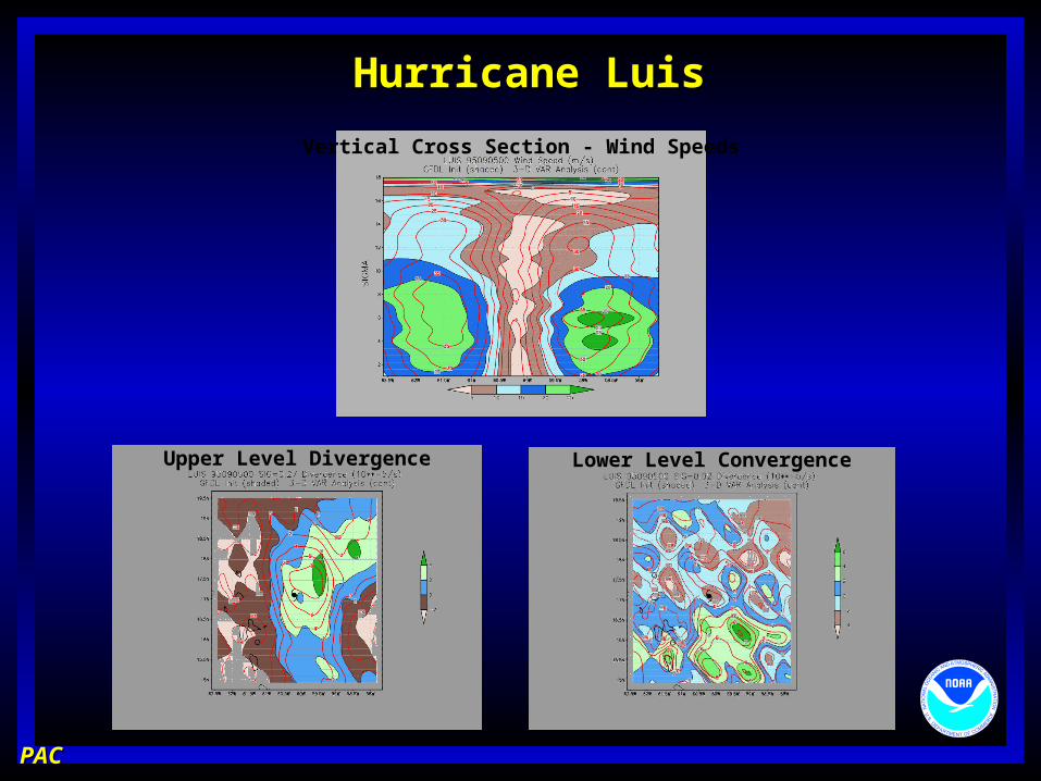
Incorporate satellites, radar, and targeted aircraft observations (e.g., G-IV and Incorporate satellites, radar, and targeted aircraft observations (e.g., G-IV and operational reconnaissance aircraft)operational reconnaissance aircraft)
Mid and Low Level WindsMid and Low Level Winds Upper Level WindsUpper Level Winds
U.S. Weather Research Program (USWRP)U.S. Weather Research Program (USWRP)(+$16.4M)(+$16.4M)
Expected ResultsExpected Results
Implement research and operational assessment (USWRP Plan for HAL)Implement research and operational assessment (USWRP Plan for HAL) Support HAL multi-year field programsSupport HAL multi-year field programs Reduce landfall track and intensity forecasts error by 20%Reduce landfall track and intensity forecasts error by 20% Increase warning leadtime to and beyond 24 h with 95% confidence without Increase warning leadtime to and beyond 24 h with 95% confidence without
increasing the present 3 to 1 overwarningincreasing the present 3 to 1 overwarning Make skillful (compared to persistence) forecasts of onset Make skillful (compared to persistence) forecasts of onset
of galeof gale(34-kt) and hurricane force (64-kt) radii out to 48 h(34-kt) and hurricane force (64-kt) radii out to 48 h
U.S. Weather Research Program (USWRP)U.S. Weather Research Program (USWRP)(+$16.4M)(+$16.4M)
Expected ResultsExpected Results
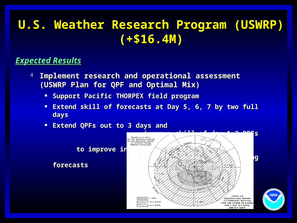
Implement research and operational assessment (USWRP Plan Implement research and operational assessment (USWRP Plan for QPF and Optimal Mix)for QPF and Optimal Mix)
Support Pacific THORPEX field programSupport Pacific THORPEX field program Extend skill of forecasts at Day 5, 6, 7 by two full daysExtend skill of forecasts at Day 5, 6, 7 by two full days Extend QPFs out to 3 days and improve Extend QPFs out to 3 days and improve
skill of day 1-3 QPFs to improve skill of day 1-3 QPFs to improve inland flooding inland flooding forecastsforecasts
Advanced Hydrologic Prediction Service (AHPS)Advanced Hydrologic Prediction Service (AHPS)(+$6.1M)(+$6.1M)
What?What? Improve flood and river predictions to move people out of harm’s way (longer lead times; Improve flood and river predictions to move people out of harm’s way (longer lead times;
probabilistic river forecast information for risk-based decisions)probabilistic river forecast information for risk-based decisions) Enhance snow-water equivalent observations for Spring floodingEnhance snow-water equivalent observations for Spring flooding
Why?Why? 75 percent of Presidentially- declared disasters are flood 75 percent of Presidentially- declared disasters are flood
related related Respond to user needs for improved river stage Respond to user needs for improved river stage
forecasts forecasts Capitalize on $1M in FY 2001 President’s budgetCapitalize on $1M in FY 2001 President’s budget AccelerateAccelerate implementation across the country at implementation across the country at
reduced costsreduced costs
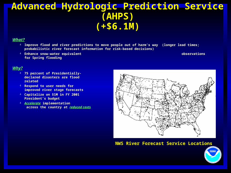
NWS River Forecast Service LocationsNWS River Forecast Service Locations
Advanced Hydrologic Prediction Service (AHPS)Advanced Hydrologic Prediction Service (AHPS)(+$6.1M)(+$6.1M)
Previous Program ServicesPrevious Program Services Basin by basin implementationBasin by basin implementation
Fund full calibration at all basinsFund full calibration at all basins
Use static modelUse static model Services delivered only when all components are readyServices delivered only when all components are ready
Graphical productsGraphical products Forecasts with probability levelsForecasts with probability levels Inundation mapping at 10% of forecasts locationsInundation mapping at 10% of forecasts locations
Limited snow dataLimited snow data
Total Cost = $106M
New Program ServicesNew Program Services Faster nationwide implementationFaster nationwide implementation
Use existing RFC model calibration at 60% of forecast Use existing RFC model calibration at 60% of forecast locationslocations
Fund full calibration at remaining 40% forecast locationsFund full calibration at remaining 40% forecast locations Provide initial graphical services at 12 versus 2 River Provide initial graphical services at 12 versus 2 River
Forecast Centers in FY00Forecast Centers in FY00
Infuse new hydrologic/hydraulic modelsInfuse new hydrologic/hydraulic models
Incremental service deliveryIncremental service delivery Graphical products available when initial calibration is Graphical products available when initial calibration is
ready for a forecast locationready for a forecast location Predictions with probability information available when Predictions with probability information available when
full calibration ready for a forecast locationfull calibration ready for a forecast location Inundation maps available at all forecast sites when Inundation maps available at all forecast sites when
partners provide topographic datapartners provide topographic data
Expand snow water equivalent dataExpand snow water equivalent data
Total Cost = $44M
Advanced Hydrologic Prediction Service (AHPS)Advanced Hydrologic Prediction Service (AHPS)(+$6.1M)(+$6.1M)
ActionsActions
Provide National delivery of web-ready Provide National delivery of web-ready graphical productsgraphical products
Infuse new hydrology and hydraulic Infuse new hydrology and hydraulic models into operations models into operations
Collect snow-water equivalent Collect snow-water equivalent data nationwide data nationwide
Provide training/outreachProvide training/outreach
VerificationVerification
National Airborne Snow Surveys
• 500 present airborne measurements/year• 3300 proposed airborne measurements/year(including 670 new measurements in Alaska)
Advanced Hydrologic Prediction Service (AHPS)Advanced Hydrologic Prediction Service (AHPS)(+$6.1M)(+$6.1M)
Expected ResultsExpected Results
Extend current 1, 2, 3 day river forecasts out to 2 Extend current 1, 2, 3 day river forecasts out to 2 weeks and beyondweeks and beyond
Provide river forecasts with uncertainty information Provide river forecasts with uncertainty information for for risk-based decisionsrisk-based decisions
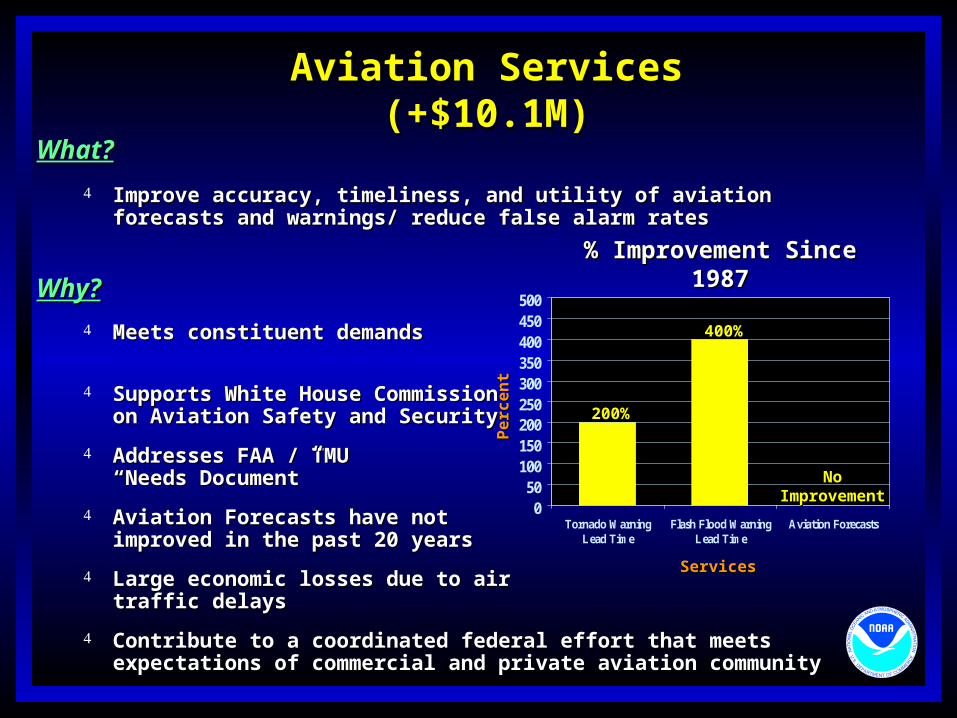
Improve accuracy, timeliness, and utility of aviation forecasts and Improve accuracy, timeliness, and utility of aviation forecasts and warnings/ reduce false alarm rateswarnings/ reduce false alarm rates
Why?Why?
Meets constituent demands for Meets constituent demands for improved servicesimproved services
Supports White House Commission Supports White House Commission on Aviation Safety and Securityon Aviation Safety and Security
Aviation Forecasts have not Aviation Forecasts have not improved in the past 20 yearsimproved in the past 20 years
Large economic losses due to air Large economic losses due to air traffic delaystraffic delays
Contribute to a coordinated federal effort that meets expectations of Contribute to a coordinated federal effort that meets expectations of commercial and private aviation communitycommercial and private aviation community
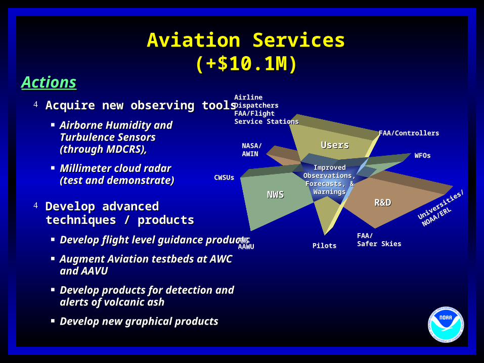
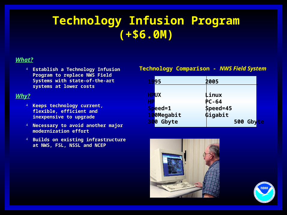
What?What? Establish a Technology Infusion Establish a Technology Infusion
Program to replace NWS Field Program to replace NWS Field Systems with state-of-the-art systems Systems with state-of-the-art systems at lower costsat lower costs
Sustain development and demonstration of new technology for Sustain development and demonstration of new technology for NWS Field SystemsNWS Field Systems
Prototype and risk reduction (develop 5 testbeds)Prototype and risk reduction (develop 5 testbeds)
Expected ResultsExpected Results
More flexible field system upgrade at lower costsMore flexible field system upgrade at lower costs
Technological basis for advanced, accurate, timely, detailed Technological basis for advanced, accurate, timely, detailed forecasts and warningsforecasts and warnings
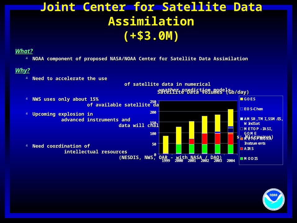
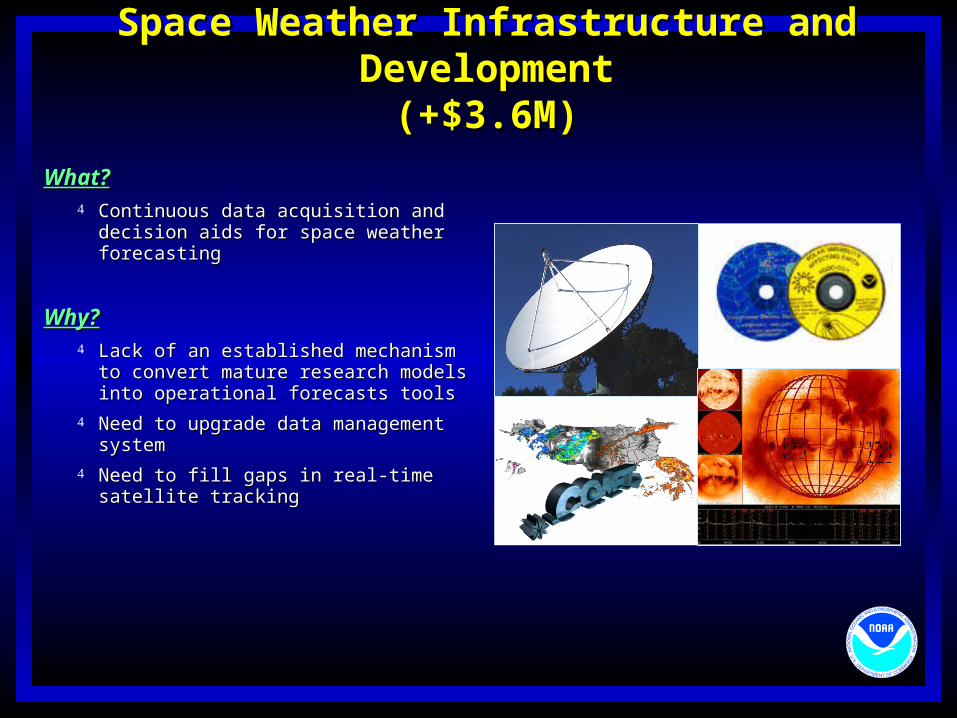
Joint Center for Satellite Data AssimilationJoint Center for Satellite Data Assimilation(+$3.0M)(+$3.0M)
What?What? NOAA component of proposed NASA/NOAA Center for Satellite Data AssimilationNOAA component of proposed NASA/NOAA Center for Satellite Data Assimilation
Why?Why? Need to accelerate the use of satellite Need to accelerate the use of satellite
data in numerical weather prediction modelsdata in numerical weather prediction models
NWS uses only about 15% of available NWS uses only about 15% of available satellite datasatellite data
Upcoming explosion in advanced instruments Upcoming explosion in advanced instruments and data will challenge entire and data will challenge entire research community (NPOES; research community (NPOES; GPS; Lidar winds; Microwave) GPS; Lidar winds; Microwave)
Need coordination of intellectual resources Need coordination of intellectual resources (NESDIS, NWS, OAR - with NASA / DAO) (NESDIS, NWS, OAR - with NASA / DAO)
Satellite Data Volumes (Gb/day)Satellite Data Volumes (Gb/day)
Joint Center for Satellite Data AssimilationJoint Center for Satellite Data Assimilation(+$3.0M)(+$3.0M)
ActionsActions Establish joint center (with NASA as Establish joint center (with NASA as
partner)partner)
Address “emissivity over land” issue to Address “emissivity over land” issue to expand utilization of satellite radiancesexpand utilization of satellite radiances
Create “forward radiance transfer models” Create “forward radiance transfer models” for all new instruments; OPTRANS for all new instruments; OPTRANS extensionsextensions
Focus on data assimilation (e.g., GPS, Focus on data assimilation (e.g., GPS, GIFTS)GIFTS)
OSSE evaluation for advanced OSSE evaluation for advanced instrumentationinstrumentation
Expanded use of satellite dataExpanded use of satellite data
Extension of range of useful forecastsExtension of range of useful forecasts
More accurate short-term mesoscale forecast - More accurate short-term mesoscale forecast - severe weathersevere weather
Improved planning of future satellite instrumentsImproved planning of future satellite instruments
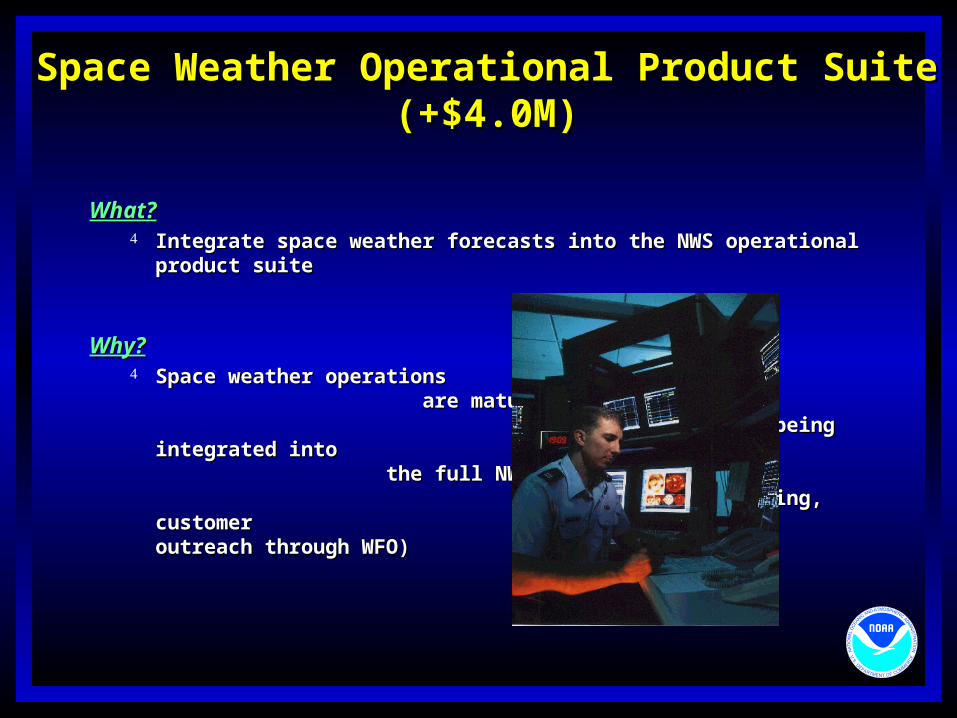
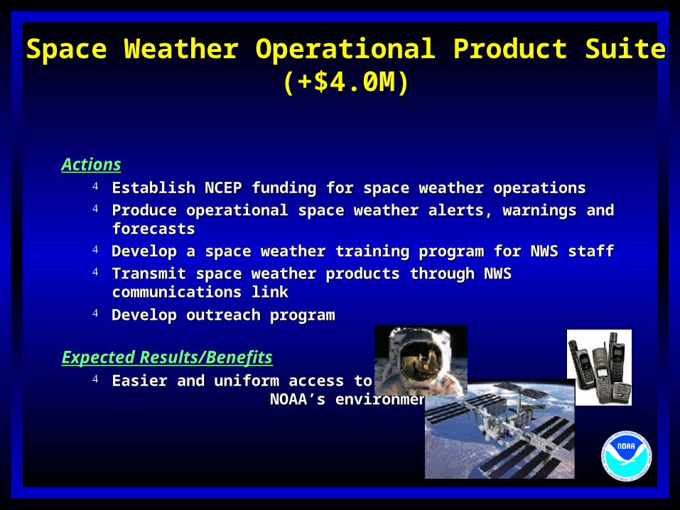
Space Weather Operational Product SuiteSpace Weather Operational Product Suite(+$4.0M)(+$4.0M)
What?What? Integrate space weather forecasts into the NWS operational Integrate space weather forecasts into the NWS operational
product suiteproduct suite
Why?Why? Space weather operations Space weather operations
are mature but limited by are mature but limited by not being integrated into not being integrated into the full NWS infrastructure the full NWS infrastructure (comms, training, customer (comms, training, customer outreach through WFO)outreach through WFO)
Space Weather Operational Product SuiteSpace Weather Operational Product Suite(+$4.0M)(+$4.0M)
ActionsActions Establish NCEP funding for space weather operationsEstablish NCEP funding for space weather operations Produce operational space weather alerts, warnings and Produce operational space weather alerts, warnings and
forecastsforecasts Develop a space weather training program for NWS staffDevelop a space weather training program for NWS staff Transmit space weather products through NWS communications Transmit space weather products through NWS communications
linklink Develop outreach programDevelop outreach program
Expected Results/BenefitsExpected Results/Benefits Easier and uniform access to NOAA’s Easier and uniform access to NOAA’s
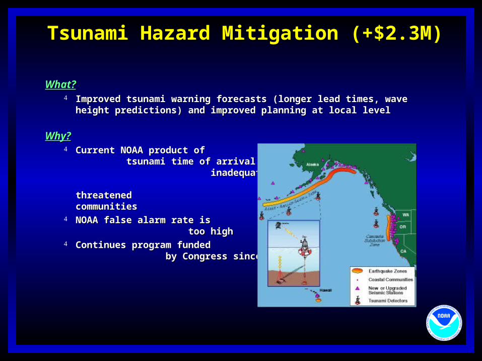
What?What? Improved tsunami warning forecasts (longer lead times, wave height Improved tsunami warning forecasts (longer lead times, wave height
predictions) and improved planning at local levelpredictions) and improved planning at local level
Why?Why? Current NOAA product of tsunami time Current NOAA product of tsunami time
of arrival is inadequate to protect life of arrival is inadequate to protect life and property for threatened and property for threatened communities communities
NOAA false alarm rate is too highNOAA false alarm rate is too high Continues program funded by Continues program funded by
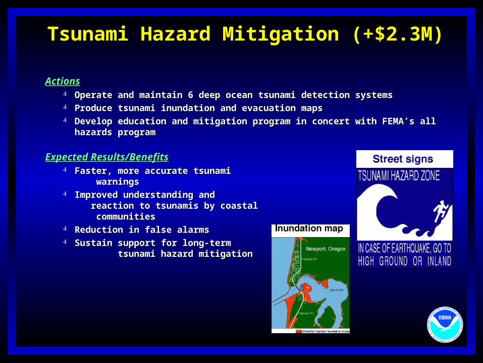
ActionsActions Operate and maintain 6 deep ocean tsunami detection systemsOperate and maintain 6 deep ocean tsunami detection systems Produce tsunami inundation and evacuation mapsProduce tsunami inundation and evacuation maps Develop education and mitigation program in concert with FEMA’s all Develop education and mitigation program in concert with FEMA’s all
hazards programhazards program
Expected Results/BenefitsExpected Results/Benefits Faster, more accurate tsunami warningsFaster, more accurate tsunami warnings Improved understanding and reaction to Improved understanding and reaction to
tsunamis by coastal communitiestsunamis by coastal communities Reduction in false alarmsReduction in false alarms Sustain support for long-term tsunami hazard Sustain support for long-term tsunami hazard
mitigationmitigation
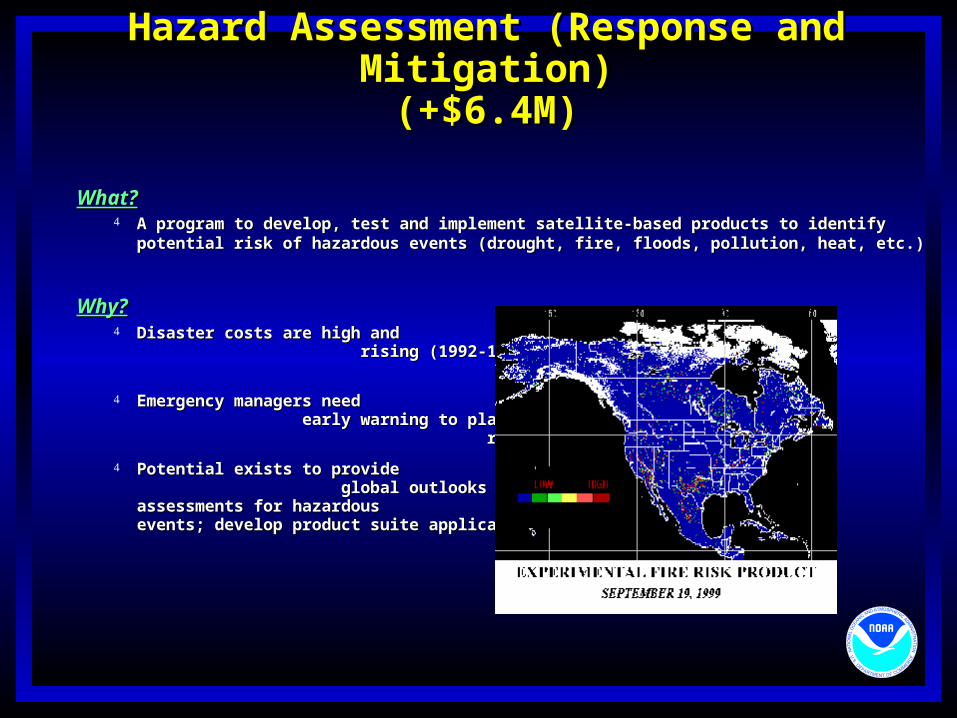
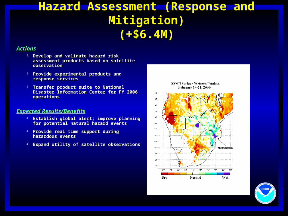
Hazard Assessment (Response and Mitigation)Hazard Assessment (Response and Mitigation)(+$6.4M)(+$6.4M)
What?What? A program to develop, test and implement satellite-based products to identify A program to develop, test and implement satellite-based products to identify
Emergency managers need early warning Emergency managers need early warning to plan for response and mitigationto plan for response and mitigation
Potential exists to provide global outlooks Potential exists to provide global outlooks and and assessments for hazardous assessments for hazardous events; develop product suite applicable for GDINevents; develop product suite applicable for GDIN
Hazard Assessment (Response and Mitigation)Hazard Assessment (Response and Mitigation)(+$6.4M)(+$6.4M)
ActionsActions Develop and validate hazard risk Develop and validate hazard risk
assessment products based on satellite assessment products based on satellite observationobservation
Provide experimental products and Provide experimental products and response servicesresponse services
Transfer product suite to National Disaster Transfer product suite to National Disaster Information Center for FY 2006 operationsInformation Center for FY 2006 operations
Expected Results/BenefitsExpected Results/Benefits Establish global alert; improve planning for Establish global alert; improve planning for
NOAA Science Center Facility (+$.5M)NOAA Science Center Facility (+$.5M)
$1.0M total request$1.0M total request
World Weather Building inadequate to meet NCEP infrastructure support World Weather Building inadequate to meet NCEP infrastructure support requirementsrequirements
crowded vintage 1973 work spacecrowded vintage 1973 work space inadequate environmental controlsinadequate environmental controls cannot facilitate synergistic interaction with research communitycannot facilitate synergistic interaction with research community
Initial funding for requirements development, alternatives, and other Initial funding for requirements development, alternatives, and other studies for a new state-of-the-art NOAA Science Centerstudies for a new state-of-the-art NOAA Science Center
Joint effort between NCEP, NESDIS, and OARJoint effort between NCEP, NESDIS, and OAR
NASA interaction: Facilitate Joint NASA/NOAA Center for Satellite Data NASA interaction: Facilitate Joint NASA/NOAA Center for Satellite Data AssimilationAssimilation
PACPAC
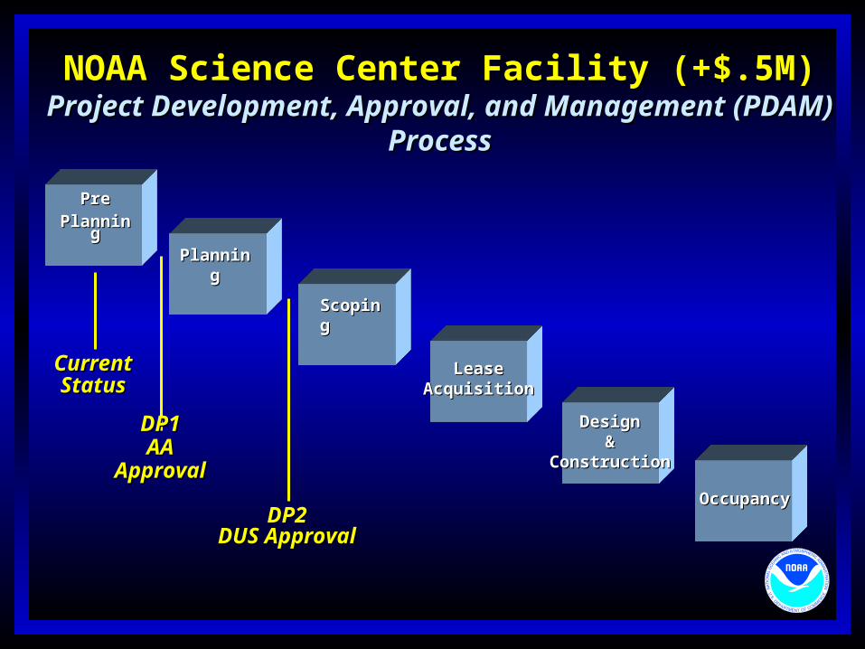
NOAA Science Center Facility (+$.5M)NOAA Science Center Facility (+$.5M)Project Development, Approval, and Management (PDAM)Project Development, Approval, and Management (PDAM)
ProcessProcess
PrePre
PlanningPlanning
ScopingScoping
LeaseLeaseAcquisitionAcquisition
DesignDesign&&
ConstructionConstruction
OccupancyOccupancy
CurrentCurrentStatusStatus
DP2DP2DUS ApprovalDUS Approval
PlanningPlanning
DP1DP1AA ApprovalAA Approval
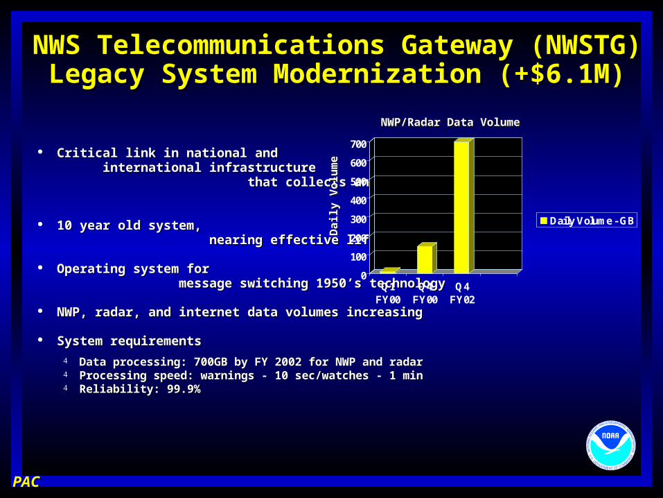
NWS Telecommunications Gateway (NWSTG)NWS Telecommunications Gateway (NWSTG)Legacy System Modernization (+$6.1M)Legacy System Modernization (+$6.1M)
Critical link in national and international Critical link in national and international infrastructure that collects and distributes infrastructure that collects and distributes weather data weather data
10 year old system, nearing 10 year old system, nearing effective life cycleeffective life cycle
Operating system for message Operating system for message switching 1950’s technologyswitching 1950’s technology
NWP, radar, and internet data volumes increasingNWP, radar, and internet data volumes increasing
System requirementsSystem requirements
Data processing: 700GB by FY 2002 for NWP and radarData processing: 700GB by FY 2002 for NWP and radar Processing speed: warnings - 10 sec/watches - 1 minProcessing speed: warnings - 10 sec/watches - 1 min Reliability: 99.9%Reliability: 99.9%
PACPAC
0
100
200
300
400
500
600
700
Q1FY00
Q4FY00
Q4FY02
Daily Volume - GBDai
ly V
olu
me
Dai
ly V
olu
me
NWP/Radar Data VolumeNWP/Radar Data Volume
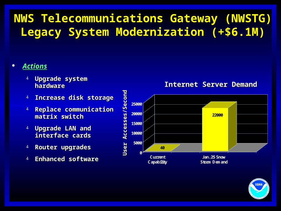
NWS Telecommunications Gateway (NWSTG)NWS Telecommunications Gateway (NWSTG)Legacy System Modernization (+$6.1M)Legacy System Modernization (+$6.1M)
40
22000
0
5000
10000
15000
20000
25000
CurrentCapability
Jan. 25 SnowStorm Demand
Internet Server DemandInternet Server Demand
Use
r A
cces
ses/
Sec
ond
Use
r A
cces
ses/
Sec
ond
ActionsActions
Upgrade system hardware Upgrade system hardware
Increase disk storage Increase disk storage
Replace communication Replace communication matrix switch matrix switch
Upgrade LAN and interface Upgrade LAN and interface cards cards
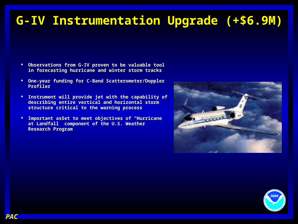
Observations from G-IV proven to be valuable tool in Observations from G-IV proven to be valuable tool in forecasting hurricane and winter storm tracksforecasting hurricane and winter storm tracks
One-year funding for C-Band Scatterometer/Doppler One-year funding for C-Band Scatterometer/Doppler ProfilerProfiler
Instrument will provide jet with the capability of Instrument will provide jet with the capability of describing entire vertical and horizontal storm structure describing entire vertical and horizontal storm structure critical to the warning processcritical to the warning process
Important asset to meet objectives of “Hurricane at Important asset to meet objectives of “Hurricane at Landfall” component of the U.S. Weather Research Landfall” component of the U.S. Weather Research ProgramProgram
Implement new algorithms in WSR-88D Precipitation Processing Implement new algorithms in WSR-88D Precipitation Processing Subsystem to improve quality of rainfall productsSubsystem to improve quality of rainfall products (particularly in cool (particularly in cool season and in mountainous areas)season and in mountainous areas)
Improve radar signal qualityImprove radar signal quality (techniques for range/velocity uncertainty (techniques for range/velocity uncertainty mitigation)mitigation)
Distinguish among rain, snow and hail (dual polarization Distinguish among rain, snow and hail (dual polarization improvements)improvements)
Replace radio frequency generator and analog receiver (digital) Replace radio frequency generator and analog receiver (digital) beginning beginning in FY03in FY03
Complete Open Systems Radar Product Generator (ORPG) Complete Open Systems Radar Product Generator (ORPG) acquisition and deployment at 125 sitesacquisition and deployment at 125 sites
Begin Open Systems Radar Data Acquisition (ORDA) with 31 Begin Open Systems Radar Data Acquisition (ORDA) with 31 unitsunits
Begin FAA radar integrationBegin FAA radar integration
Begin level II data archiveBegin level II data archive
ASOS Product Improvement (+$2.5M)ASOS Product Improvement (+$2.5M)
$7.6M total request$7.6M total request
Critical Technology Infusion Program Critical Technology Infusion Program necessary to meet NWS and necessary to meet NWS and FAA requirementsFAA requirements
Profile change:Profile change:
Restore acquisition profile to maintain Restore acquisition profile to maintain schedule goals/prioritiesschedule goals/priorities
ASOS Product Improvement (+$2.5M)ASOS Product Improvement (+$2.5M)
ActionsActions
Complete deployment of 300 all weather precipitation gagesComplete deployment of 300 all weather precipitation gages
Complete deployment of 180 dewpoint sensorsComplete deployment of 180 dewpoint sensors
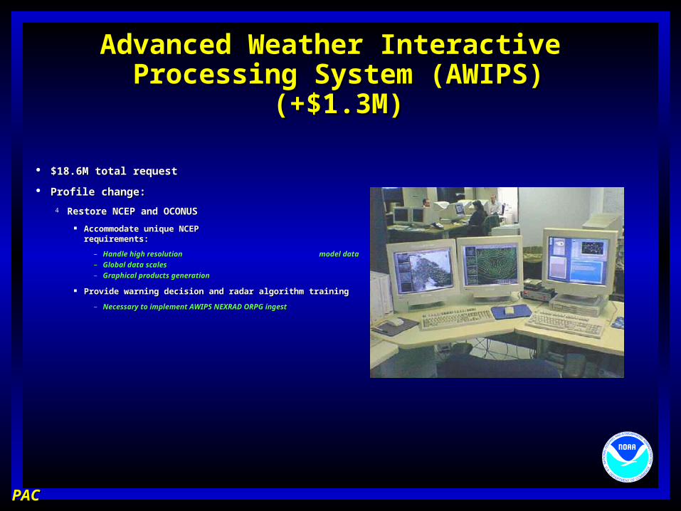
Advanced Weather Interactive Advanced Weather Interactive Processing System (AWIPS)Processing System (AWIPS)
(+$1.3M)(+$1.3M)
$18.6M total request$18.6M total request
Profile change:Profile change:
Restore NCEP and OCONUS AWIPS profileRestore NCEP and OCONUS AWIPS profile
Accommodate unique NCEP and Off-CONUS requirements:Accommodate unique NCEP and Off-CONUS requirements:
– Handle high resolution model dataHandle high resolution model data– Global data scalesGlobal data scales– Graphical products generationGraphical products generation
Provide warning decision and radar algorithm trainingProvide warning decision and radar algorithm training
– Necessary to implement AWIPS NEXRAD ORPG ingestNecessary to implement AWIPS NEXRAD ORPG ingest
PACPAC
Advanced Weather Interactive Advanced Weather Interactive Processing System (AWIPS)Processing System (AWIPS)
(+$1.3M)(+$1.3M)
ActionsActions
Complete Build 5.0 development and implementationComplete Build 5.0 development and implementation
Continue established technology infusion program:Continue established technology infusion program: Open RPG ingestOpen RPG ingest NCEP/OCONUS capabilitiesNCEP/OCONUS capabilities Hydromet decision assistanceHydromet decision assistance Catastrophic backup for NCF, master ground station, Catastrophic backup for NCF, master ground station,
terrestrial linesterrestrial lines Increased communications bandwidth for enhanced NWP Increased communications bandwidth for enhanced NWP
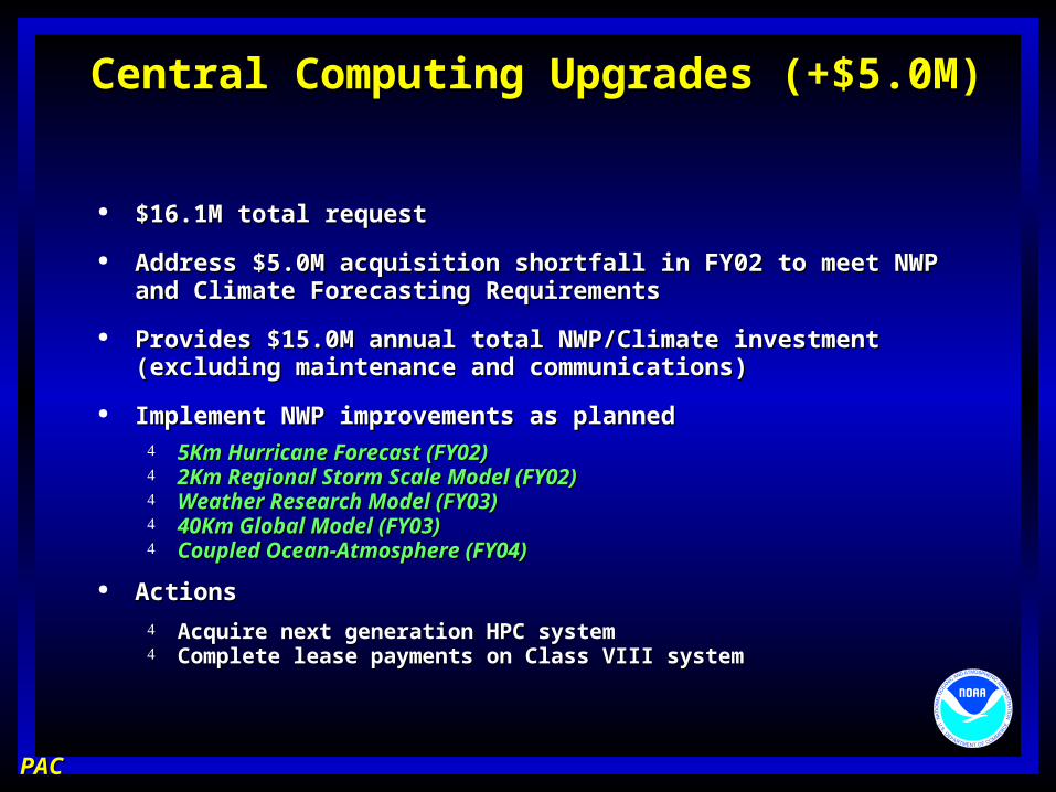
Central Computing Upgrades (+$5.0M)Central Computing Upgrades (+$5.0M)
$16.1M total request$16.1M total request
Address $5.0M acquisition shortfall in FY02 to meet NWP and Climate Address $5.0M acquisition shortfall in FY02 to meet NWP and Climate Forecasting RequirementsForecasting Requirements
Provides $15.0M annual total NWP/Climate investment (excluding Provides $15.0M annual total NWP/Climate investment (excluding maintenance and communications)maintenance and communications)
Implement NWP improvements as plannedImplement NWP improvements as planned 5Km Hurricane Forecast (FY02)5Km Hurricane Forecast (FY02) 2Km Regional Storm Scale Model (FY02)2Km Regional Storm Scale Model (FY02) Weather Research Model (FY03)Weather Research Model (FY03) 40Km Global Model (FY03)40Km Global Model (FY03) Coupled Ocean-Atmosphere (FY04)Coupled Ocean-Atmosphere (FY04)
ActionsActions
Acquire next generation HPC systemAcquire next generation HPC system Complete lease payments on Class VIII systemComplete lease payments on Class VIII system
PACPAC
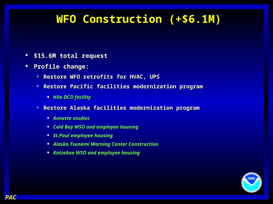
WFO Construction (+$6.1M)WFO Construction (+$6.1M)
$15.6M total request$15.6M total request
Profile change:Profile change:
Restore WFO retrofits for HVAC, UPSRestore WFO retrofits for HVAC, UPS
Restore Pacific facilities modernization programRestore Pacific facilities modernization program
Hilo DCO facilityHilo DCO facility
Restore Alaska facilities modernization programRestore Alaska facilities modernization program
Annette studiesAnnette studies
Cold Bay WSO and employee housingCold Bay WSO and employee housing
St.Paul employee housingSt.Paul employee housing
Alaska Tsunami Warning Center ConstructionAlaska Tsunami Warning Center Construction
Kotzebue WSO and employee housingKotzebue WSO and employee housing
PACPAC
WFO Construction (+$6.1M)WFO Construction (+$6.1M)
ActionsActions
Key West designKey West design
Caribou post award provisionsCaribou post award provisions
Cold Bay WSO and employee housingCold Bay WSO and employee housing
St.Paul employee housingSt.Paul employee housing
Alaska Tsunami Warning Center ConstructionAlaska Tsunami Warning Center Construction
Kotzebue WSO and employee housingKotzebue WSO and employee housing
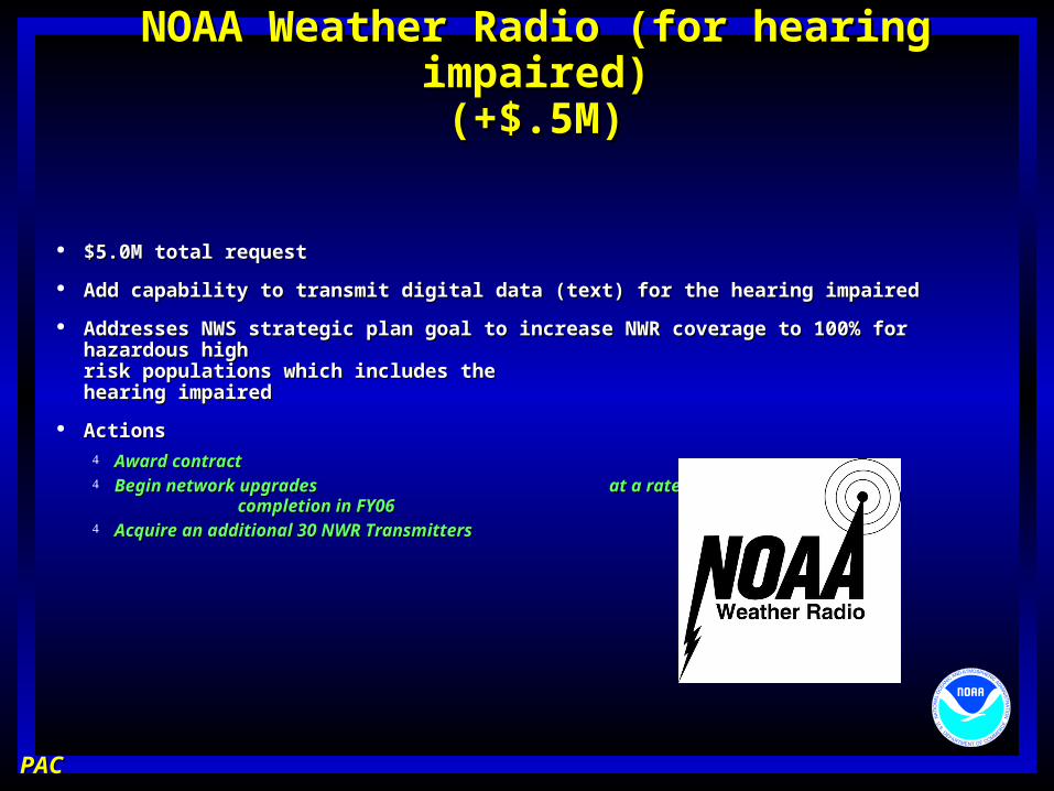
NOAA Weather Radio (for hearing impaired)NOAA Weather Radio (for hearing impaired)(+$.5M)(+$.5M)
$5.0M total request$5.0M total request
Add capability to transmit digital data (text) for the hearing impairedAdd capability to transmit digital data (text) for the hearing impaired
Addresses NWS strategic plan goal to increase NWR coverage to 100% for Addresses NWS strategic plan goal to increase NWR coverage to 100% for hazardous high hazardous high risk populations which includes the risk populations which includes the hearing impairedhearing impaired
ActionsActions Award contractAward contract Begin network upgrades at a rate of 170 per year - Begin network upgrades at a rate of 170 per year -
completion in FY06 completion in FY06 Acquire an additional 30 NWR TransmittersAcquire an additional 30 NWR Transmitters
PACPAC
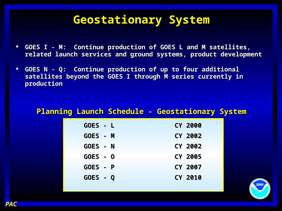
Geostationary SystemGeostationary System
GOES I - M: Continue production of GOES L and M satellites, GOES I - M: Continue production of GOES L and M satellites, related launch services and ground systems, product developmentrelated launch services and ground systems, product development
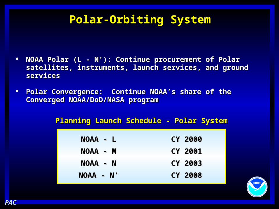
GOES N - Q: Continue production of up to four additional satellites GOES N - Q: Continue production of up to four additional satellites beyond the GOES I through M series currently in productionbeyond the GOES I through M series currently in production
NOAA Polar (L - N’): Continue procurement of Polar satellites, NOAA Polar (L - N’): Continue procurement of Polar satellites, instruments, launch services, and ground servicesinstruments, launch services, and ground services
Polar Convergence: Continue NOAA’s share of the Converged Polar Convergence: Continue NOAA’s share of the Converged NOAA/DoD/NASA programNOAA/DoD/NASA program
Align resources with accepted service Align resources with accepted service improvement goalsimprovement goals
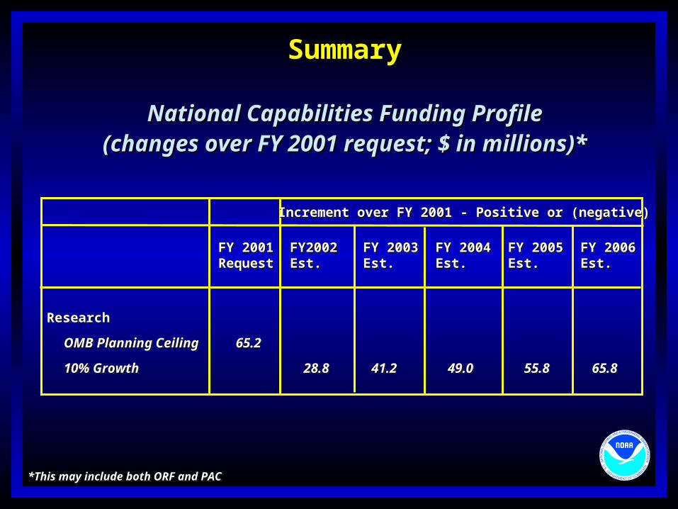
SummarySummary
National Capabilities Funding ProfileNational Capabilities Funding Profile(changes over FY 2001 request; $ in millions)*(changes over FY 2001 request; $ in millions)*
Increment over FY 2001 - Positive or (negative)Increment over FY 2001 - Positive or (negative)
FY 2001 FY2002 FY 2003 FY 2004 FY 2005 FY 2006Request Est. Est. Est. Est. Est.FY 2001 FY2002 FY 2003 FY 2004 FY 2005 FY 2006Request Est. Est. Est. Est. Est.
*This may include both ORF and PAC*This may include both ORF and PAC
Research
OMB Planning Ceiling 65.2
10% Growth 28.8 41.2 49.0 55.8 65.8
Research
OMB Planning Ceiling 65.2
10% Growth 28.8 41.2 49.0 55.8 65.8
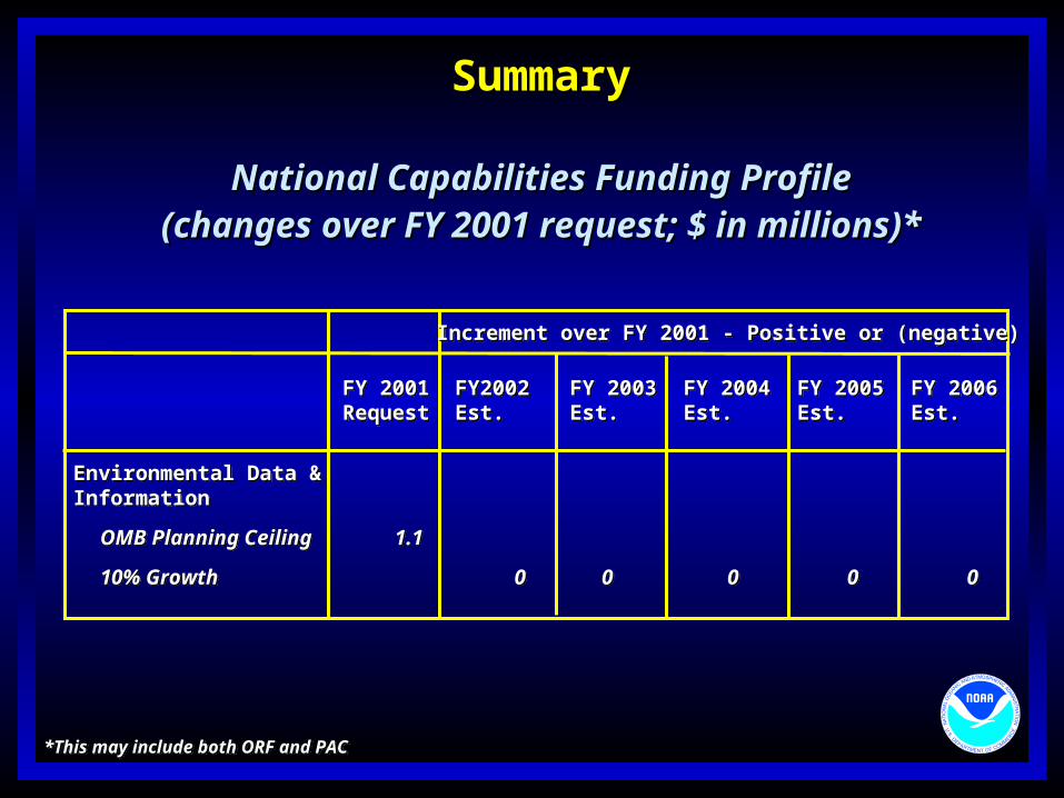
SummarySummary
National Capabilities Funding ProfileNational Capabilities Funding Profile(changes over FY 2001 request; $ in millions)*(changes over FY 2001 request; $ in millions)*
Increment over FY 2001 - Positive or (negative)Increment over FY 2001 - Positive or (negative)
FY 2001 FY2002 FY 2003 FY 2004 FY 2005 FY 2006Request Est. Est. Est. Est. Est.FY 2001 FY2002 FY 2003 FY 2004 FY 2005 FY 2006Request Est. Est. Est. Est. Est.
Environmental Data &Information
OMB Planning Ceiling 1.1
10% Growth 0 0 0 0 0
Environmental Data &Information
OMB Planning Ceiling 1.1
10% Growth 0 0 0 0 0
*This may include both ORF and PAC*This may include both ORF and PAC
SummarySummary
National Capabilities Funding ProfileNational Capabilities Funding Profile(changes over FY 2001 request; $ in millions)*(changes over FY 2001 request; $ in millions)*
Increment over FY 2001 - Positive or (negative)Increment over FY 2001 - Positive or (negative)
FY 2001 FY2002 FY 2003 FY 2004 FY 2005 FY 2006Request Est. Est. Est. Est. Est.FY 2001 FY2002 FY 2003 FY 2004 FY 2005 FY 2006Request Est. Est. Est. Est. Est.
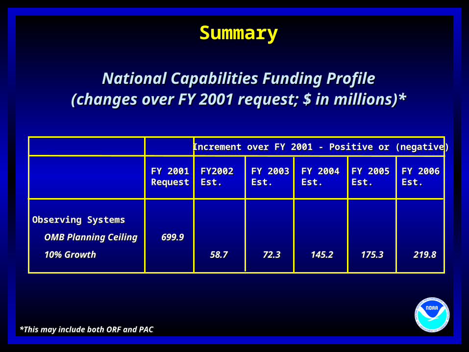
Observing Systems
OMB Planning Ceiling 699.9
10% Growth 58.7 72.3 145.2 175.3 219.8
Observing Systems
OMB Planning Ceiling 699.9
10% Growth 58.7 72.3 145.2 175.3 219.8
*This may include both ORF and PAC*This may include both ORF and PAC
SummarySummary
National Capabilities Funding ProfileNational Capabilities Funding Profile(changes over FY 2001 request; $ in millions)*(changes over FY 2001 request; $ in millions)*
Increment over FY 2001 - Positive or (negative)Increment over FY 2001 - Positive or (negative)
FY 2001 FY2002 FY 2003 FY 2004 FY 2005 FY 2006Request Est. Est. Est. Est. Est.FY 2001 FY2002 FY 2003 FY 2004 FY 2005 FY 2006Request Est. Est. Est. Est. Est.
Infrastructure
OMB Planning Ceiling 12.5
10% Growth 25.6 5.6 36.3 32.3 11.6
Infrastructure
OMB Planning Ceiling 12.5
10% Growth 25.6 5.6 36.3 32.3 11.6
*This may include both ORF and PAC*This may include both ORF and PAC
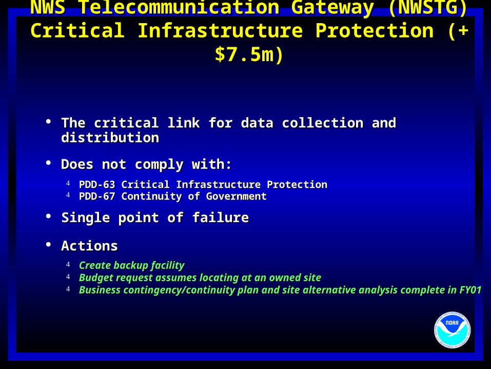
The critical link for data collection and distributionThe critical link for data collection and distribution
Does not comply with:Does not comply with: PDD-63 Critical Infrastructure ProtectionPDD-63 Critical Infrastructure Protection PDD-67 Continuity of GovernmentPDD-67 Continuity of Government
Single point of failureSingle point of failure
ActionsActions Create backup facilityCreate backup facility Budget request assumes locating at an owned siteBudget request assumes locating at an owned site Business contingency/continuity plan and site alternative analysis Business contingency/continuity plan and site alternative analysis
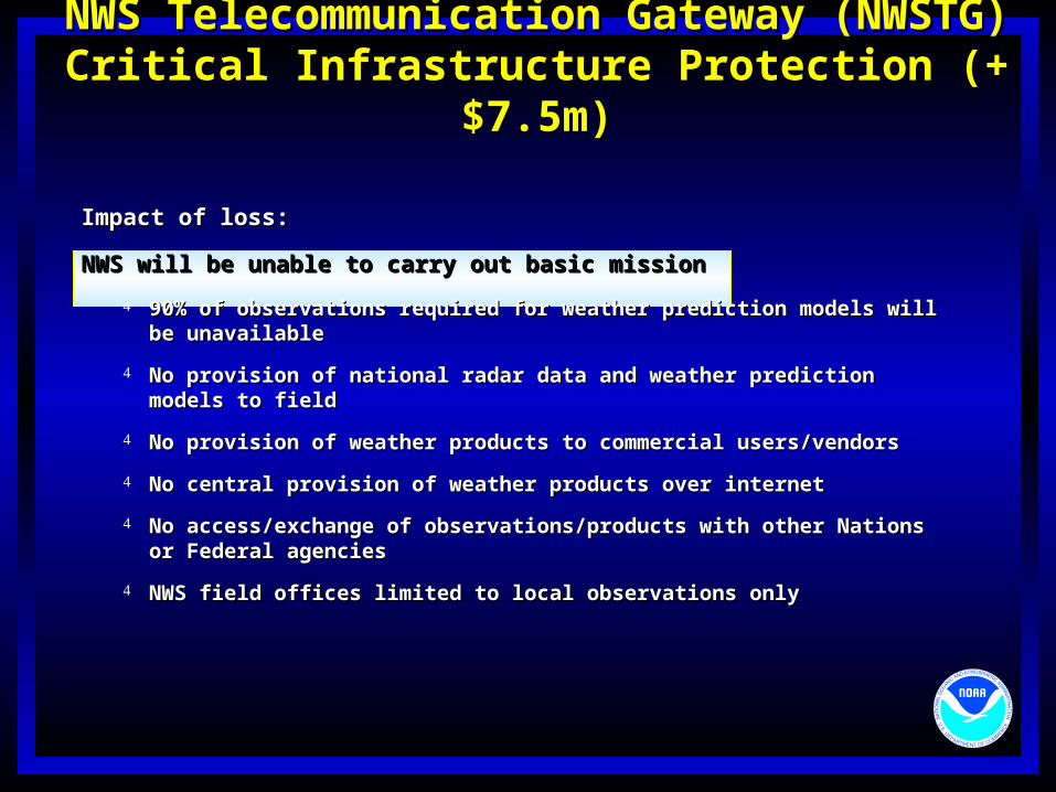
NWS will be unable to carry out basic missionNWS will be unable to carry out basic mission
90% of observations required for weather prediction models will be 90% of observations required for weather prediction models will be unavailableunavailable
No provision of national radar data and weather prediction models to fieldNo provision of national radar data and weather prediction models to field
No provision of weather products to commercial users/vendorsNo provision of weather products to commercial users/vendors
No central provision of weather products over internetNo central provision of weather products over internet
No access/exchange of observations/products with other Nations or No access/exchange of observations/products with other Nations or Federal agenciesFederal agencies
NWS field offices limited to local observations onlyNWS field offices limited to local observations only