54
APPENDIX H - CONCEPT OF OPERATIONS Spokane Regional Transportation Management Center Advanced Traffic Management System Replacement Concept of Operations
APPENDIX H - CONCEPT OF OPERATIONS
Spokane Regional Transportation Management Center
Advanced Traffic Management System Replacement Concept of Operations

i
Table of Contents
PURPOSE OF DOCUMENT ............................................................................................ 2
CHAPTER 11.1. Introduction .............................................................................................................................................. 2
1.2. Systems Engineering ................................................................................................................................. 3
1.3. Report Organization .................................................................................................................................. 4
SCOPE OF PROJECT ....................................................................................................... 6 CHAPTER 2
2.1. Purpose of ATMS and High-Level Description ............................................................................................ 6
2.2. Roles and Responsibilities ......................................................................................................................... 7
REFERENCED DOCUMENTS ........................................................................................ 9 CHAPTER 3
BACKGROUND ON CURRENT ATMS SYSTEM ...................................................... 11 CHAPTER 4
4.1. Spokane Region ITS Architecture ............................................................................................................. 11
4.2. Spokane Regional Traffic Management Center (SRTMC) ......................................................................... 13
4.3. Existing ATMS Overview .......................................................................................................................... 14 4.3.1. System Overview ................................................................................................................................... 14 4.3.2. Current Operations ................................................................................................................................ 15 4.3.3. Strengths and Shortcomings of the Existing ATMS ................................................................................ 15
4.4. Regional Planning Context ...................................................................................................................... 17 4.4.1. Federally-Mandated Performance Planning .......................................................................................... 17 4.4.2. Regional Congestion Management Process (CMP) ................................................................................ 18 4.4.3. Air Quality Planning ............................................................................................................................... 21 4.4.4. Regional Travel Demand Model Calibration and Validation .................................................................. 21 4.4.5. Active Transportation Planning ............................................................................................................. 21
4.5. Goals from Prior ITS Planning Efforts ....................................................................................................... 22 4.5.1. Transportation Management Center ..................................................................................................... 22 4.5.2. Regional Traffic Control ......................................................................................................................... 22 4.5.3. Regional Traveler Information ............................................................................................................... 22 4.5.4. Road Weather Operations ..................................................................................................................... 23 4.5.5. Maintenance and Construction Operations .......................................................................................... 23
ii
4.5.6. Incident Management ........................................................................................................................... 23 4.5.7. Public Transportation ............................................................................................................................ 23 4.5.8. Regional Communications Infrastructure .............................................................................................. 24 4.5.9. Archived Data Management .................................................................................................................. 24
4.6. High-Level Approach to ATMS Replacement ........................................................................................... 25
CONCEPT FOR THE PROPOSED SYSTEM .............................................................. 26
CHAPTER 5 USER-ORIENTED OPERATIONAL DESCRIPTION ............................................... 28
CHAPTER 6 OPERATIONAL NEEDS ................................................................................................ 32
CHAPTER 7 SYSTEM OVERVIEW .................................................................................................... 34
CHAPTER 8 OPERATIONAL ENVIRONMENT ............................................................................... 36
CHAPTER 9
SUPPORT ENVIRONMENT ..................................................................................... 38 CHAPTER 10
OPERATIONAL SCENARIOS .................................................................................. 40 CHAPTER 11
11.1. Normal Operations – No events, No incidents ......................................................................................... 40
11.2. Major Traffic Incident .............................................................................................................................. 42
11.3. Major Planned Special Event (like Bloomsday) ........................................................................................ 43
11.4. Data Archiving and Retrieval ................................................................................................................... 44
11.5. Winter Operations .................................................................................................................................. 47
SUMMARY OF IMPACTS ......................................................................................... 48
CHAPTER 12
1
List of Tables
Table 1: Concept of Operations Chapter Overview ...................................................................................... 4 Table 2: Highlights of Service Areas and Packages within the Current Spokane Regional ITS Architecture (from the 2013 Spokane Region Intelligent Transportation Systems Plan) ................................................ 11 Table 3. SRTMC Goals .............................................................................................................................. 13 Table 4. Current ATMS Strengths and Shortcomings ............................................................................... 16 Table 5. Federal and Regional Performance Measures .............................................................................. 17 Table 6. CMP Performance Measures ....................................................................................................... 20 Table 7: Core Stakeholders with Roles and Responsibilities ...................................................................... 28 Table 8: Supporting Stakeholder Roles and Responsibilities ..................................................................... 30 Table 9 Operational Needs for New ATMS ............................................................................................... 32 Table 10: Data Archiving and Retrieval Scenario Components ................................................................. 44 Table 11: Impacts to Core Stakeholders ..................................................................................................... 48 Table 12: Supporting Stakeholder Impacts ................................................................................................. 50
List of Figures
Figure 1: Concept of Operations Process ...................................................................................................... 3 Figure 2: Systems Engineering Vee Diagram Highlighting the Concept of Operations .............................. 4 Figure 3: Transportation Management Center Operational Concept for Years 2013-2023 .......................... 7 Figure 4. CMP Corridors ........................................................................................................................... 19 Figure 5: ATMS Operational Environment ................................................................................................ 36 Figure 6: SRTMC ....................................................................................................................................... 38
2
Chapter 1Purpose of Document
1.1. Introduction The Concept of Operations document captures stakeholder input that will drive the ATMS design so that it will ultimately yield the tools needed by STRMC and its partners to meet regional transportation goals.
The Spokane Area ATMS Replacement Concept of Operations:
• Provides the stakeholder “vision” for the ATMS system o Based on needs o Reflects stakeholder discussion and consensus o Contains a description of and rationale for the desired operations o Documents the vision to help communicate it
• Defines the environment in which the ATMS system operates, including the relationships between the ATMS system and
o Agency responsibilities, practices, and procedures o The physical environment o Expectations
• Identifies roles and responsibilities of the agencies involved • Forms the basis for high-level requirements that will be used to procure the ATMS software
3
This document is the fourth and final step in the concept of operations process:
The results from steps 1 and 3, the interviews and the workshop, are throughout this document.
1.2. Systems Engineering Recognizing the value of systems engineering in successful Intelligent Transportation Systems (ITS) programs, both the Federal Highway Administration and the Washington State Department of Transportation (WSDOT) require use of the systems engineering process. This Concept of Operations is structured to include elements necessary for systems engineering. It is part of several activities and documents throughout the process to procure the new ATMS that collectively fulfill the systems engineering requirements, requirements that are proven to enhance ITS investment.
The FHWA rules are contained within Chapter 23 of the Code of Federal Regulations in section 940.11. The WSDOT Design Manual’s Systems Engineering section is designated 1050.03.
As shown in the generalized systems engineering vee diagram in Figure 2, the Concept of Operations draws on the Regional ITS Architecture and sets the stage for system requirements that will be the basis of system design.
1
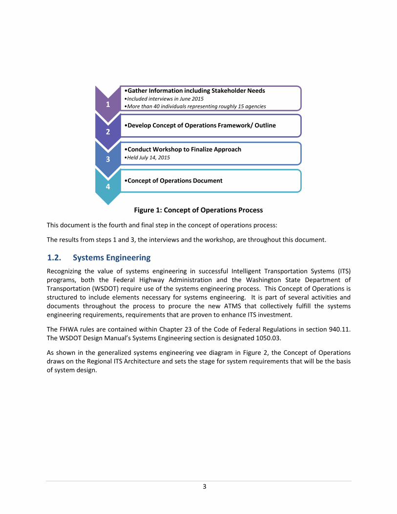
•Gather Information including Stakeholder Needs •Included interviews in June 2015 •More than 40 individuals representing roughly 15 agencies
2 •Develop Concept of Operations Framework/ Outline
3 •Conduct Workshop to Finalize Approach •Held July 14, 2015
4 •Concept of Operations Document
Figure 1: Concept of Operations Process

4
Figure 2: Systems Engineering Vee Diagram Highlighting the Concept of Operations
Following through the steps of system installations and testing, note that system validation references back to the Concept of Operations. System validation is the check that system which has been designed and implemented will meet the needs established during the Concept of Operations. If it does, the system will provide the tools that the stakeholders can use to operate the system as envisioned to meet needs. Thus, the Concept of Operations is critical to understanding what the proposed ATMS system is intended to do.
1.3. Report Organization As recommended by the WSDOT Design Manual, Chapter 1050 Intelligent Transportation, Section 1050.03, this Concept of Operations follows the Concept of Operations template in the USDOT/CalTrans document, Systems Engineering Guidebook for Intelligent Transportation Systems, Version 3, November 2009. Table 1 shows the adapted chapter numbering and high-level contents.
Table 1: Concept of Operations Chapter Overview
Number and Name Contents
1 Purpose of Document
This chapter is a brief statement of the purpose of this document. It includes its context within the Systems Engineering process. It also includes the organization of the document.
2 Scope of Project
This short chapter gives a brief overview of the system to be built. It includes its purpose and a high-level description. It introduces the roles and responsibilities of the key agencies involved.

5
3 Referenced Documents
This lists supporting documentation used and other resources that are useful in understanding the operations of the system.
4
Background on Current ATMS System
This chapter includes a brief description of the current ATMS system and its operations. This leads into the reasons for the proposed development and the general approach to improving the system. This is followed by a discussion of the nature of the planned changes and a justification for them.
5
Concept for the Proposed System
This chapter describes the concept for the ATMS replacement system. It starts with a description of the vision for the ATMS as documented in the 2013 Spokane Region ITS Plan. This leads into a presentation for the selected concept. This is not a design, but a high-level, conceptual, operational description.
6
User-Oriented Operational Description
This chapter focuses on how the goals and objectives are accomplished currently. Specifically, it describes who the users and stakeholders are and what the users do. It covers the operations that take place, agency responsibilities, personnel capabilities, personnel and inter-agency interactions, and types of activities. It describes the roles and responsibilities of each stakeholder agency.
7 Operational Needs
This chapter provides a description of the vision, goals & objectives, and personnel needs that drive the requirements for the system. Specifically, this describes what the system needs to do. It describes the systems needs that must continue to be met by the replacement ATMS system. Each need will eventually be supported by at least one system requirement.
8 System Overview
This chapter describes the proposed system’s scope, what it interfaces with, and its planned capabilities. It provides a structure for describing the operations, in terms of specific system features.
9 Operational Environment
This chapter describes the physical operational environment in terms of the ITS architecture, facilities, hardware, software, and communication interfaces necessary to operate the system.
10 Support Environment
This chapter describes the current and planned physical support environment. This includes facilities, personnel, operational roles, and maintenance and support responsibilities. This includes expected support from outside agencies. It includes a staffing concept for operating and maintaining the ATMS.
11 Operational Scenarios
This chapter presents scenarios such that each stakeholder can clearly see what his or her expected role is to be. Each scenario describes a sequence of events, activities carried out by the user, the system, and the environment. The chapter documents the operational scenario discussion with the stakeholders during the Concept of Operations workshop.
12 Summary of Impacts
This is an analysis of the proposed system and the impacts on each of the stakeholders. It is presented from the viewpoint of each, so that they can readily understand and validate how the proposed system will impact their operations.
6
Chapter 2Scope of Project
2.1. Purpose of ATMS and High-Level Description The ATMS is essential software and hardware used by TMCs to efficiently enable many transportation management functions. The concept for ATMS in general has developed from a collection of software controlling individual ITS device types to a powerful tool consolidating multiple systems in a user-friendly interface including visualizing monitoring and control of a variety of ITS devices and other inputs as well archiving data, facilitating coordination among agencies, and automating some functions. An ATMS can now also provide a single platform for both devices traditionally found on freeways and arterials.
As documented in the 2013 Spokane Region ITS Plan, the SRTMC needs an up-to-date and fully functional ATMS to meet transportation needs that have grown in scale and breadth since the original ATMS was implemented in 2001. For scale, the number and type of ITS devices has grown as well as the types of roadways covered. For breadth, transportation management increasingly includes data-driven performance management, traveler information through social media, and multi-modal transportation management.
Therefore, WSDOT, on behalf of the SRTMC partner agencies, established the following objectives for procuring a new ATMS (as recorded in the Notice for Consultants for Traffic Engineering Services for ATMS Replacement):
1. Replace a dated and no longer vendor supported system 2. Provide better level of functionality over the current ATMS system (both actual and intended
functionality); and 3. Consider and include additional functionality available as appropriate.
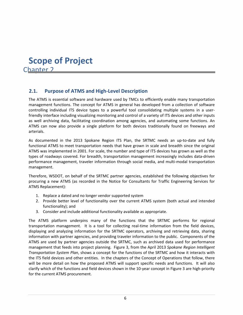
The ATMS platform underpins many of the functions that the SRTMC performs for regional transportation management. It is a tool for collecting real-time information from the field devices, displaying and analyzing information for the SRTMC operators, archiving and retrieving data, sharing information with partner agencies, and providing traveler information to the public. Components of the ATMS are used by partner agencies outside the SRTMC, such as archived data used for performance management that feeds into project planning. Figure 3, from the April 2013 Spokane Region Intelligent Transportation System Plan, shows a concept for the functions of the SRTMC and how it interacts with the ITS field devices and other entities. In the chapters of the Concept of Operations that follow, there will be more detail on how the proposed ATMS will support specific needs and functions. It will also clarify which of the functions and field devices shown in the 10-year concept in Figure 3 are high-priority for the current ATMS procurement.
7
Figure 3: Transportation Management Center Operational Concept for Years 2013-2023
2.2. Roles and Responsibilities The ATMS will be the primary software used by the Spokane Regional Transportation Management Center (SRTMC). The SRTMC is a partnership of six regional agencies:
• City of Spokane • City of Spokane Valley • Spokane County • Spokane Regional Transportation Council • Spokane Transit Authority • Washington State Department of Transportation, Eastern Region
These six agencies are the core stakeholders and provide direction as well as funding for SRTMC and the ATMS. WSDOT manages the SRTMC. WSDOT, the City of Spokane, the City of Spokane Valley, and Spokane County have ITS field devices and/or communications networks that interface with the SRTMC. SRTC utilizes transportation data as part of its regional transportation planning responsibilities. The Spokane Transit Authority operates both fixed route and paratransit service throughout the region and can use roadway condition information to improve service, especially when there are detours, special events, incidents, or inclement weather. Additional detail on the roles and responsibilities of the SRTMC and its member agencies is included in Chapter 6.

8
Additional entities with ties to the ATMS include the fire and police departments in City of Spokane and the City of Spokane Valley, the Washington State Patrol, and the Idaho Transportation Department. There are a number of additional entities that might have future ties to the ATMS, including: Liberty Lake, Airway Heights, and the Spokane International Airport. See Chapter 6.
9
Chapter 3Referenced Documents
The lists show the documents that have served as references for the Concept of Operations development.
ITS Plans
• I-90 (Idaho) Corridor ITS Strategic Plan, June 2007 • City of Spokane Valley ITS Strategic Plan, May 2011 • Idaho ITS Strategic Plan Update, March 2011 • Spokane Region Intelligent Transportation Systems Plan, April 2013 • Spokane Regional ITS Architecture Plan, July 2000 • WSDOT Eastern Washington ITS Implementation Plan, March 2007
ITS Systems Engineering and Design Guidance
• Code of Federal Regulations Title 23: Highways (Part 940: ITS Architecture & Standards), January 2001
• USDOT/CalTrans Systems Engineering Guidebook for Intelligent Transportation Systems, Version 3, November 2009
• WSDOT Design Manual (Chapter 1050: ITS), July 2014
Related ITS Architectures
• Washington State ITS Architecture, July 2006 • Idaho Statewide ITS Architecture Update (within ITS Strategic Plan Update Statewide, March
2011)
Long-Rang Plans Not Specific to ITS
• Connect Spokane – A Comprehensive Plan for Public Transit, June 2015 • Spokane County Multi-Jurisdiction All Hazard Mitigation Plan, April 2007 • Spokane Metropolitan Planning Area 2011-2035 Metropolitan Transportation Plan, January
2012
Near-Term Plans not Specific to ITS
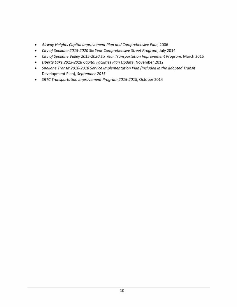
10
• Airway Heights Capital Improvement Plan and Comprehensive Plan, 2006 • City of Spokane 2015-2020 Six Year Comprehensive Street Program, July 2014 • City of Spokane Valley 2015-2020 Six Year Transportation Improvement Program, March 2015 • Liberty Lake 2013-2018 Capital Facilities Plan Update, November 2012 • Spokane Transit 2016-2018 Service Implementation Plan (Included in the adopted Transit
Development Plan), September 2015 • SRTC Transportation Improvement Program 2015-2018, October 2014

11
Chapter 4Background on Current ATMS System
4.1. Spokane Region ITS Architecture The ATMS is a system that enables many of the functions within a region’s ITS Architecture. ITS Architectures provide the vision and framework for ITS programs, including the ITS functions (for example, distribute travel times), physical subsystems (for example, roadside CCTV), and the information flows among them. The regional ITS Architectures are not specific to project corridors and do not specify technologies.
For the Spokane Region, the initial regional architecture was released in 2000 and then updated in 2007 and 2013. As mandated by the United States Department of Transportation (USDOT), the Spokane Region ITS Architecture is in conformance with the National ITS Architecture which helps related ITS programs to align with each other and the high-level direction set by USDOT through FHWA and the Federal Transit Administration (FTA.) There are two closely related architectures to the Spokane Region ITS Architecture, the Washington State ITS Architecture and the Idaho Statewide ITS Architecture.
As part of the Spokane Region ITS Architecture development, the stakeholders provide input on operational needs that lead to selection of ITS services that are existing or planned for the Spokane Region. The National ITS Architecture identifies service packages, groupings of physical ITS elements required to provide specific ITS services, to choose from that are grouped in service areas. Procurement of the ATMS is required to be in conformance with the Region’s ITS architecture so that the choices of service areas are reflected. Table 2 summarizes the Spokane Region’s choices of service areas and packages.
Table 2: Highlights of Service Areas and Packages within the Current Spokane Regional ITS Architecture (from the 2013 Spokane Region Intelligent Transportation Systems Plan)
Service Area Included Service Packages Not Included Service Packages
Archived Data Management
All of the service packages are included, such as a regional, multi-modal ITS data warehouse.
None.
Public Transportation
All of the service packages are included, such as transit vehicle tracking; transit security; and transit signal priority (planned for future following CAD/AVL implementation)
None.
Traveler Includes service packages covering Excludes service packages that depend
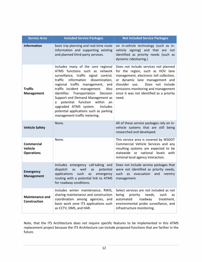
12
Service Area Included Service Packages Not Included Service Packages
Information basic trip planning and real-time route information and supporting existing and planned third-party services.
on in-vehicle technology (such as in-vehicle signing) and that are not identified as priority needs (such as dynamic ridesharing.)
Traffic Management
Includes many of the core regional ATMS functions such as network surveillance, traffic signal control, traffic information dissemination, regional traffic management, and traffic incident management. Also identifies Transportation Decision Support and Demand Management as a potential function within an upgraded ATMS system. Includes potential applications such as parking management traffic metering.
Does not include services not planned for the region, such as HOV lane management, electronic toll collection, or dynamic lane management and shoulder use. Does not include emissions monitoring and management since it was not identified as a priority need.
Vehicle Safety None. All of these service packages rely on in-
vehicle systems that are still being researched and developed.
Commercial Vehicle Operations
None. This service area is covered by WSDOT Commercial Vehicle Services and any resulting systems are expected to be statewide or national levels with minimal local agency interaction.
Emergency Management
Includes emergency call-taking and dispatch as well as potential applications such as emergency routing with a potential link to ATMS for roadway conditions.
Does not include service packages that were not identified as priority needs, such as evacuation and reentry management.
Maintenance and Construction
Includes winter maintenance, RWIS, sharing maintenance and construction coordination among agencies, and basic work zone ITS applications such as CCTV, DMS, and HAR.
Select services are not included as not being priority needs, such as automated roadway treatment, environmental probe surveillance, and infrastructure monitoring.
Note, that the ITS Architecture does not require specific features to be implemented in this ATMS replacement project because the ITS Architecture can include proposed functions that are farther in the future.

13
4.2. Spokane Regional Traffic Management Center (SRTMC) The SRTMC is the heart of traffic management for the Spokane area, a collaboration of agencies and modes to serve transportation throughout the region.
The SRTMC is managed through an interlocal agreement between WSDOT Eastern Region, City of Spokane, City of Spokane Valley, Spokane County, Spokane Transit Authority (STA) and the Spokane Regional Transportation Council (SRTC), the region’s metropolitan planning organization. The original Interlocal Agreement was signed in 1998 and led to the SRTMC opening in 2002. SRTMC operations are overseen by an Operations Board, consisting of staff-level representatives from each agency that is party to the agreement.
The 900 square foot SRTMC is co-located with SRTC and the region’s Amtrak and Greyhound Intercity Bus station at the Spokane Intermodal Center. It includes four operator workstations, a video wall, and a communications room. WSDOT houses some ITS infrastructure and statewide systems servers separately at its Eastern Region Office in Spokane. The City of Spokane also has a server for their traffic signals. Both the City of Spokane and the City of Spokane Valley have workstations for the existing ATMS.
The 2013 Spokane Regional ITS Plan provides the following overarching vision for the SRTMC:
The vision for the SRTMC is to actively coordinate and support the overall regional transportation infrastructure and respond to events across jurisdictional boundaries through a joint partnership that reduces congestion and maximizes the efficiency and safety of the transportation network.
Specific SRTMC responsibilities are described in detail the 2013 Spokane Regional ITS Plan and generally include network surveillance, traveler information dissemination, incident response coordination, and clearinghouse for regional databases.
Goals supporting the vision in the 2013 plan are salient to the ATMS replacement, as shown in Table 3. Several of these goals reinforce the need for a comprehensive set of regional policy and administrative procedures to fully leverage technologies deployed.
Table 3. SRTMC Goals
SRTMC Goal
Cons
ider
atio
n fo
r AT
MS
Tech
nica
l Ca
pabi
litie
s
Regi
onal
Pol
icy
Issu
e
Develop a single integrated platform for applications or information databases related to traffic management, incident management, road weather operations, and maintenance and construction operations to support efficient and safe travel and information dissemination.
X
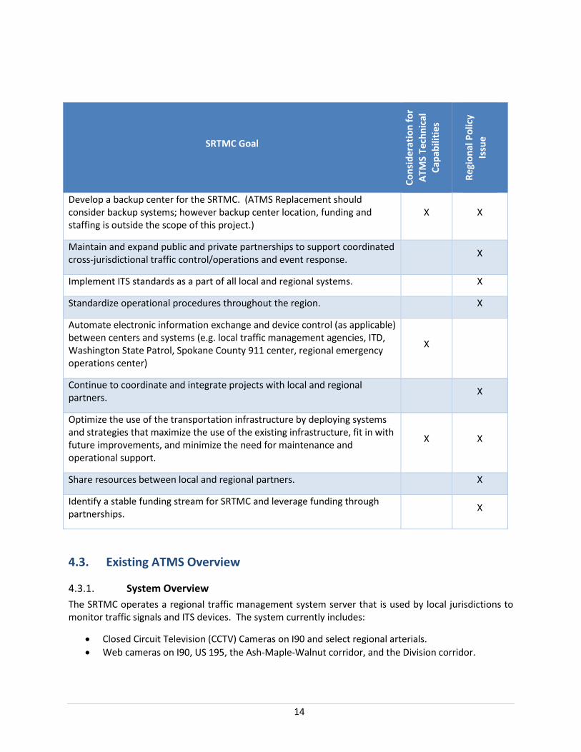
14
SRTMC Goal
Cons
ider
atio
n fo
r AT
MS
Tech
nica
l Ca
pabi
litie
s
Regi
onal
Pol
icy
Issu
e
Develop a backup center for the SRTMC. (ATMS Replacement should consider backup systems; however backup center location, funding and staffing is outside the scope of this project.)
X X
Maintain and expand public and private partnerships to support coordinated cross-jurisdictional traffic control/operations and event response. X
Implement ITS standards as a part of all local and regional systems. X
Standardize operational procedures throughout the region. X
Automate electronic information exchange and device control (as applicable) between centers and systems (e.g. local traffic management agencies, ITD, Washington State Patrol, Spokane County 911 center, regional emergency operations center)
X
Continue to coordinate and integrate projects with local and regional partners. X
Optimize the use of the transportation infrastructure by deploying systems and strategies that maximize the use of the existing infrastructure, fit in with future improvements, and minimize the need for maintenance and operational support.
X X
Share resources between local and regional partners. X
Identify a stable funding stream for SRTMC and leverage funding through partnerships. X
4.3. Existing ATMS Overview
4.3.1. System Overview The SRTMC operates a regional traffic management system server that is used by local jurisdictions to monitor traffic signals and ITS devices. The system currently includes:
• Closed Circuit Television (CCTV) Cameras on I90 and select regional arterials. • Web cameras on I90, US 195, the Ash-Maple-Walnut corridor, and the Division corridor.

15
• Dynamic Message Signs (DMS) on I90, the Maple-Ash corridor, the Division corridor, Sprague Avenue, and the 3rd Avenue corridor.
• Highway Advisory Radio (one microwave location at the junction of US2 and I-90, and two dial-up locations on I90 in Spokane Valley and Liberty Lake).
• Traffic Data Sensors on I90 and select arterials within the City of Spokane and City of Spokane Valley.
• Commercial Vehicle Information System and Weigh-In-Motion infrastructure at WSDOT Port of Entry facilities near the Idaho state line.
• Road Weather Information System (RWIS) Stations on I90 and US 395. • Center to Center (C2C) fiber optic network, with only minor gaps that agencies are working
together to complete. • Center to Field (C2F) network consisting of a mixture of fiber optic cable, twisted pair copper
interconnect, wireless communications and leased line services. The C2F network is robust with some gaps that agencies are working to address. The City of Spokane C2F network stands at 98 percent of planned.
4.3.2. Current Operations WSDOT provides eight employees for 24/7 staffing of the SRTMC, with access to most of the region’s CCTV, DMS, traffic measurement stations and highway advisory radio stations. Many separate systems are currently in use at the SRTMC controlling various aspects of the regional ATMS infrastructure:
• The SRTMC uses the client/server ATMS application to view CCTV images from analog cameras, and to operate the DMS. The application is capable of controlling signals owned by WSDOT, City of Spokane Valley, and Spokane County, but does not currently show traffic flow.
• City of Spokane signals are controlled by separate traffic signal control systems. The City of Spokane Valley is working toward its own traffic signal server.
• The SRTMC had plans for an NTCIP-compliant C2C link between the ATMS and traffic signal control systems that would have included the ability to share City of Spokane and City of Spokane Valley traffic data and enable SRTMC operators to monitor signals in those two jurisdictions. However, the link is not functional.
• Older generations of RWIS and DMS are controlled through separate central systems from newer generation equipment.
• The SRTMC serves separately as WSDOT’s radio communications hub for the region, and primarily uses an interactive web-based application known as the radio log for recording events and incident information. The radio log was developed internally by WSDOT and provides a standardized means of entering information by TMC operators. The radio log is a legal record and subject to public disclosure.
• SRTMC operators also have access to WSDOT’s web-based Performance Management System (PeMS) data for historical traffic sensor data analysis.
4.3.3. Strengths and Shortcomings of the Existing ATMS Table 4 summarizes high level strengths of the current ATMS and key areas where improvement would be beneficial. While the ATMS Replacement will improve technical capabilities at the SRTMC, a number of shortcomings for the current system have no technological solution and instead will require regional

16
collaboration on policy, staffing, funding resources and administrative standards. These management elements are of critical importance, since any potential technical efficiencies to be gained depend upon an adequate administrative framework.
Agency partners are currently working to revise an interlocal agreement for the SRTMC to comprehensively cover existing and future operations initiatives, use of shared ITS equipment, maintenance requirements, funding and governance issues. Complete implementation of the new ATMS will require additional work on operational policies and procedures, in order to fully leverage the system’s technical capabilities.
Table 4. Current ATMS Strengths and Shortcomings
Strengths Areas for Improvement
There is a strong commitment by agency partners to leverage ATMS improvements to the mutual benefit of all partners.
SRTMC and partner agency staff are technically proficient.
SRTMC operators currently have access to most of the region’s ITS devices.
Protocols for communication between SRTMC staff and incident response teams are working well.
Communications infrastructure serving agencies within Spokane County is robust with very few gaps. STA is working to integrate real-time area transportation system information from the TMC into STA’s transit dispatch center to support public transportation operations.
ITS planning processes have been vigorous and collaborative. The regional ITS plan is current and individual agencies are making good use of planning priorities to advance projects from long-term plans to near term capital improvement programs and ultimate implementation.
Disparate systems at the TMC hinder efficient operations and implementation of incident response measures.
Traveler information is disseminated through multiple agencies and technical platforms, making coordination cumbersome.
The region has not been able to draw upon the full extent of the current system’s technical features and capabilities. Specific regional policy guidelines and standard operating procedures could help utilize more of the system’s features.
Lack of operational backup capabilities places the current system at risk in the event of an emergency situation at the TMC requiring evacuation.
C2C communications are lacking - from the ATMS to City of Spokane traffic signal system, to Spokane Valley traffic signal system, and to ITD.
C2F communications infrastructure system-wide has numerous gaps.
SRTMC staff lack the ability and authority to invoke alternate signal timing plans under incident or emergency situations.
Viewing and control of CCTV, RWIS and other features by multiple jurisdictions is not currently possible.
Lack of data access and analysis tools limit the
17
Strengths Areas for Improvement
current system’s ability to support regional planning and engineering needs.
4.4. Regional Planning Context There are significant opportunities for the ATMS to support regional planning and engineering processes through the addition of efficient data management tools.
A summary of regional planning processes, including data sets needed for these processes, is provided below.
4.4.1. Federally-Mandated Performance Planning Federal metropolitan planning rules require that the Spokane region use a performance-based approach to transportation decision-making. SRTC is responsible for long-range planning activities, and must identify operational and management strategies to relieve vehicular congestion and maximize the safety and mobility of people and goods. The availability and fidelity of regional traffic operations data is key to this work.
A number of Federal performance measures are included in recent Notices of Proposed Rulemaking (NPRM’s) issued by the Federal Highway Administration (FHWA). In addition, metropolitan areas are encouraged to develop additional performance measures which are specific and meaningful for their region. SRTC has recently adopted six guiding principles for long-range planning, and the agency is considering several region-specific performance measures to help guide investment and track progress toward regional goals.
Table 5 lists both pending Federal performance measures and proposed region-specific measures. Those measures which may benefit from the availability of improved ATMS data are noted.
Table 5. Federal and Regional Performance Measures
Performance Measure Federal Regional ATMS Data Opportunity
Number of Fatalities and Serious Injuries x x
Rate of Fatalities and Serious Injuries x x
Bicycle and Pedestrian Fatalities and Serious Injuries x
Bridge and Pavement Condition on the Interstate and NHS x
SRTC Guiding Principles Economic Vitality
Cooperation and Leadership
Stewardship
System Operations, Maintenance and Preservation
Quality of Life/Choice and Mobility
Safety and Security
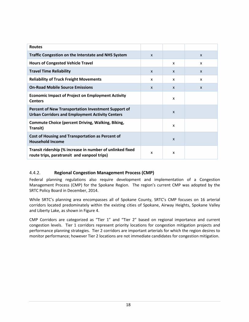
18
Routes
Traffic Congestion on the Interstate and NHS System x x
Hours of Congested Vehicle Travel x x
Travel Time Reliability x x x
Reliability of Truck Freight Movements x x x
On-Road Mobile Source Emissions x x x
Economic Impact of Project on Employment Activity Centers x
Percent of New Transportation Investment Support of Urban Corridors and Employment Activity Centers x
Commute Choice (percent Driving, Walking, Biking, Transit) x
Cost of Housing and Transportation as Percent of Household Income x
Transit ridership (% increase in number of unlinked fixed route trips, paratransit and vanpool trips) x x
4.4.2. Regional Congestion Management Process (CMP) Federal planning regulations also require development and implementation of a Congestion Management Process (CMP) for the Spokane Region. The region’s current CMP was adopted by the SRTC Policy Board in December, 2014.
While SRTC’s planning area encompasses all of Spokane County, SRTC’s CMP focuses on 16 arterial corridors located predominately within the existing cities of Spokane, Airway Heights, Spokane Valley and Liberty Lake, as shown in Figure 4.
CMP Corridors are categorized as “Tier 1” and “Tier 2” based on regional importance and current congestion levels. Tier 1 corridors represent priority locations for congestion mitigation projects and performance planning strategies. Tier 2 corridors are important arterials for which the region desires to monitor performance; however Tier 2 locations are not immediate candidates for congestion mitigation.

19
SRTC has established a set of specific performance measures (Table 6) that serve as an overall congestion management score card. Regional planning staff are less than satisfied with the current availability and quality of data for performance measuring and monitoring. For example, measures requiring travel time information have relied upon third party privately maintained data, for which data confidence is generally poor for the Spokane Region.
Source: SRTC Final CMP, December 2014
Figure 4. CMP Corridors

20
Table 6. CMP Performance Measures
CMP PERFORMANCE MEASURE
CURRENT DATA SOURCES AND METHODOLOGY
ISSUES
Freight Tonnage in CMP Corridors
While this measure is “tonnage”, the current metric actually reported by SRTC is the % heavy vehicles per AADT for WSDOT and ADT for Spokane Valley.
Direct data on freight tonnage is not currently available. If truck classification data were available for CMP corridors, this measure could be calculated using a standard WSDOT formula. (See “Instructions for FGTS Truck Tonnage Estimation”, Appendix N of the Washington State Freight and Goods Transportation System 2011 Update, March 2012.)
Travel Time Index (TTI) Averages and Peaks on Corridors
Derived from INRIX Traffic Analytics Historic Probe Data Explorer Tool.
TTI = Actual travel time as a percent of free flow time.
Data confidence is generally poor. Also WSDOT contract with data provider has expired - data no longer available to SRTC.
Project Cost ($)/Planning Time Index (PTI)
PTI = near-worst case travel time as a percent of free flow travel time. Derived from INRIX Traffic Analytics Historic Probe Data Explorer Tool.
Project Cost = amount shown in SRTC’s TIP.
(This performance measure is intended to gauge the effectiveness of implemented projects within CMP corridors. It is calculated in the year following project construction.)
Data confidence is generally poor. Also, WSDOT contract with data provider has expired and data is no longer available to SRTC.
Collision Rate per Million VMT
3-year rolling average annual collision data from WSDOT Transportation Data and GIS Office. (Data originates from police reports.)
Annual VMT for corridor segments is estimated based on SRTC regional travel demand model.
Accuracy of VMT estimates is unknown. Model calibration considered only screenline level findings. SRTC advises that, anecdotally, model appears to have reasonably good correlation to actual corridor volumes; however, a corridor-level analysis of model accuracy is not currently available.

21
CMP PERFORMANCE MEASURE
CURRENT DATA SOURCES AND METHODOLOGY
ISSUES
Incident Clearance Time on I90
WSDOT Gray Notebook Gray Notebook currently reports clearance times for only two sections of I90.
Transit Reliability Factor Not currently calculated. Future measure intended to report travel time reliability for buses.
4.4.3. Air Quality Planning While data derived from SRTC’s travel demand model is currently adequate to meet SRTC’s federally mandated air quality conformity analyses, the region’s air quality goals could also be assessed at the project level to assist with prioritizing investments. The availability of consistent, reliable data on 24-hour traffic volumes, intersection delays and incident clearance times could help project proponents make the case for air quality funding, and improve confidence that selected investments will work toward air quality goals.
4.4.4. Regional Travel Demand Model Calibration and Validation SRTC’s travel demand model is updated and recalibrated somewhat infrequently (typically 4-6 year intervals). Data for model calibration and validation is currently provided by individual jurisdictions in various formats. Manual formatting and quality control assurance processes currently used to get the data into a consistent template are inconvenient and time consuming. Automated collection and formatting of traffic data where possible would help to reduce this effort.
The regional travel demand model has primarily been used for future traffic volume predictions. However, as SRTC begins to address new federal performance planning requirements, use of the regional model to help set future performance targets is likely to increase. Calibration and validation efforts will need to evolve accordingly, and real-time data on vehicular delays, speeds, and travel times would help to facilitate this.
4.4.5. Active Transportation Planning In recent years, SRTC has provided stakeholder forums and regional plans aimed at increasing transportation options for walking and bicycling. This includes regional bicycle and pedestrian plans, plus a “SmartRoutes” initiative for regional projects and strategies to improve the safety and convenience of trails, sidewalks and bicycle facilities. Based on recent performance planning discussions with stakeholders, this is an area where SRTC anticipates additional planning and on-going data needs.
An initial installation of eight non-motorized count stations is anticipated for the region, with locations to be selected by SRTC in the fall of 2015. It is anticipated that initial equipment installations will likely focus on non-motorized trail facilities. Additional ATMS provisions for collecting and accessing data on bicycle and pedestrian use on and across arterial corridors throughout the region would be beneficial.
22
4.5. Goals from Prior ITS Planning Efforts Goals from the SRTMC 2013 Regional ITS Plan that are relevant for the ATMS Concept of Operations are summarized below according to service area. (Policy, administrative and staffing needs, and individual agency ITS equipment installations, are excluded from these lists.)
4.5.1. Transportation Management Center • Integrate the existing disparate systems into one integrated platform for all SRTMC activities. • Consider backup operations, with a backup SRTMC potentially located at the WSDOT Eastern
Region office. • Integrate SRTMC systems with local transportation and emergency management agencies. • Consider integration with ITD District 1 equipment for bi-state regional traffic management. • Expand the SRTMC’s capabilities to allow SRTMC operators to deploy a pre-set traffic signal
coordination plan.
4.5.2. Regional Traffic Control • Integrate all agency traffic signals into a central platform that can be accessed by SRTMC
operators and all agencies that operate traffic signals. • Consider adaptive signal timing where feasible. • Accommodate transit signal priority along key STA routes. • Accommodate cameras and system detection for more complete network surveillance to
support traffic signal operations. • Accommodate ramp metering on I-90 on-ramps • Accommodate traffic control strategies to address queuing at I-90 off-ramps, on US 195, and at
rural hot spots.
4.5.3. Regional Traveler Information • Disseminate all regional traveler information from the SRTMC. • Expand the online SRTMC traffic flow map to include conditions on arterial roadways. • Enhance links and/or interfaces on the SRTMC website with other information sources such as
Spokane Road Fix, WSDOT’s Washington State Traveler Information, ITD’s 511 Traveler Information, North\West Passage, and STA trip planning.
• Consider future expansion of the SRTMC’s website to cover Post Falls and Coeur d’Alene. • Display travel time estimates on dynamic message signs and the SRTMC website for freeways
and key arterials, particularly where there is significant interaction between the freeway and arterials.
• Provide next bus arrival information at key transfer locations. • Provide more comprehensive and up-to-date maintenance and construction activity information
for any work, whether public agency or private utility, that impacts travel. • Integrate incident information with maintenance and construction information. • Disseminate information about parking occupancy for park and ride lots and the airport. • Provide tailored traveler information for motor carriers (e.g. weight and height restrictions). • Provide critical winter mountain pass information at rest areas. • Accommodate dynamic message signs at strategic decision points.
23
4.5.4. Road Weather Operations • Track locations of all winter vehicle fleets for resource management. • Consider traffic signal priority for snow plows. • Accommodate additional weather stations. • Automate chain-up requirement signs. • Consider variable speed limits based on winter weather conditions. • Improve notification to emergency management agencies and travelers about weather-based
road closures.
4.5.5. Maintenance and Construction Operations • Develop a regional database with comprehensive information about maintenance and
construction activities that impact travel. • Reduce maintenance and construction impacts to transit routes and schedules. • Inventory and track deployed portable ITS devices (e.g. portable dynamic message signs,
variable speed limit signs, automated speed enforcement). Accommodate a process for sharing portable ITS devices between agencies.
• Consider systems needed to support regionalizing the maintenance of ITS devices and communications infrastructure, and resource sharing for after-hours maintenance.
• Minimize the impact of freight super loads on construction projects.
4.5.6. Incident Management • Consider future co-location of the SRTMC with the 9-1-1 center or use of a TMC workstation at
the 9-1-1 center. • Coordinate with ITD for incidents along the I-90 corridor. • Integrate computer-aided dispatch (CAD) systems throughout the region. • Provide incident alerts, particularly for highways and major arterial roadways, to local
transportation management agencies. • Develop an interface between SRTMC and mayday systems (e.g. OnStar). • Improve tools for tracking and evaluating incident response times. • Provide capability for SRTMC operators to implement pre-planned incident response signal
timing plans. • Provide video feed from traffic cameras to emergency management agencies. • Develop interface for providing traffic incident information from Spokane Police Department to
Spokane traffic management personnel.
4.5.7. Public Transportation STA is currently working on these initiatives which are relevant to the ATMS replacement:
• Improve center-to-center communications connectivity between SRTMC and STA dispatch. • Accommodate updated dispatch capabilities for fixed route and demand response vehicles. • Provide capability to track the location of the entire public transportation fleet. • Add video surveillance, automatic passenger counters, and stop announcements to fixed route
vehicles.
24
• Provide video feed from traffic cameras to STA dispatchers. • Improve data connectivity between STA facilities.
Additionally, a number of needs identified in other ATMS service areas also apply to public transportation and will help minimize service delays:
• Arterial-level traffic flow maps • Comprehensive real-time maintenance and construction activity information • Improved multi-modal trip planning • Next bus arrival information • Park and ride lot occupancy information • Transit signal priority • Center-to-center communications connectivity
4.5.8. Regional Communications Infrastructure • Consider commercial options for fiber optic sharing. • Add redundancy to existing regional fiber optic backbone and create a redundant path to
SRTMC. • Expand communications network to complete center-to-center connections to key
transportation and emergency management facilities (e.g. Spokane County, ITD). • Connect all traffic signals to a central signal system. • Expand center-to-field communications network to pick up isolated ITS devices or to improve
the reliability and timeliness of communications to devices currently using slow dial-up connections.
• Develop a fully IP-based network. • Install systems to actively detect and prevent security threats.
4.5.9. Archived Data Management • Automate data collection as much as possible for each of the service areas listed above. • Collect comprehensive data about all modes (vehicles, freight, transit, bicycles, and
pedestrians). • Automate current manual data collection efforts (e.g. vehicle volume/speed/occupancy,
bicycle/pedestrian volume.) • Archive transportation data in a centralized data clearinghouse and make it publicly available
(unless restriction is needed to address security implications.) • Expand the use and capabilities of SRTMC’s Performance Measurement System (PeMS) regional
data archive. • Develop analytical planning tools for data validation, performance measurement, operational
evaluation, asset management, regional planning activities, and financial decision making. Automate these tools as much as possible.
• Develop predictive algorithm tools that use archived data to generate travel forecasts based on real-time data.
25
4.6. High-Level Approach to ATMS Replacement Support for ITS initiatives, including the ATMS software that is central to the operations of the SRTMC, has been well-documented in planning documents over many years. Over time, the needs and opportunities have grown leading directly to the current effort of replacing the pair of ATMS which are nearly 15 years old. The objectives for the new ATMS are replacing a dated and no longer maintained system, providing better functionality than the current ATMS (including better than what was planned, but hasn’t been working), and considering enhanced functionality.
The ATMS replacement effort is following the mandated systems engineering approach including the logical steps of reviewing the relevant ITS architectures and engaging stakeholders to identify needs. The ATMS replacement process is also utilizing guidance from SRTMC’s planning context as well as the context of recent ITS plans. This Concept of Operations document these and other portions of the systems engineering process that will lead into defining requirements for the proposed ATMS system that will be the basis for procuring the ATMS and for testing it once installed. These steps are proven to increase the likelihood that continued investment in ITS, including ATMS, successfully yield the improvements to transportation based on the needs and goals of stakeholders.

26
Chapter 5Concept for the Proposed System
The concept for the new Spokane Regional ATMS is built upon the experience over 15 years of operation of the existing ATMS. The concept is to update and improve the existing ATMS, not to develop a wholly new concept.
Other efforts have explored the concept for the ATMS. The 2013 Spokane Region ITS Plan presents the following concept, or vision, for regional traffic control.
The regional traffic control vision is for SRTMC partner agencies to manage and respond to dynamic transportation network conditions through cross-jurisdictional coordination using integrated and automated systems. Goals that support this vision include:
• Primarily manage traffic signal control at the local agency level and manage most other ITS traffic control from the SRTMC.
• Use common standards-based traffic control hardware and systems to support regional traffic control and network surveillance.
• Use one common central system for traffic signals. • Integrate freeway and surface street systems so that traffic management is coordinated
between the two systems where they interface. • Automate traffic signal control responses to dynamically adjust to changes in travel demand
based on current, network-wide roadway conditions. • Actively manage and respond to transportation system conditions to maintain travel time
reliability, reduce recurrent congestion, reduce fuel consumption and associated environmental impacts, preserve or improve existing system capacity, and improve safety.
• Support reduction of incident response times. • Improve public transportation operational efficiency along key travel corridors. • Use ITS applications to improve rural and urban transportation safety. • Gather wide-ranging multi-modal information (including comprehensive surveillance on
principal arterial roadways) from multiple public and private sources to support network monitoring, data collection, event response, and dissemination of traveler information.
Based on interviews and discussions with stakeholders and the results of the Concept of Operations workshop, most of these goals continue to be valid. The common central system for traffic signals would reflect the desire for coordination across local signal control systems, not the desire to have a single platform controlling all signals.
From the combination of previous efforts, such as the 2013 ITS plan, and the interviews and workshop for this effort, the following capabilities reflect the concept for the ATMS.
27
• Data collection and data archiving. The concept is to incorporate data from freeways, arterials, and the transit system into a single data warehouse. An analytics package, accessible through the ATMS with remote access, would provide users with access to the data and the ability to analyze it for a variety of purposes, including planning and performance management.
• CCTV and camera control. Access to images from and ability to control both analog and digital/IP-based cameras from a single interface. Control will depend on permissions assigned by user. Camera pre-sets will be assigned by time of day and by user.
• Dynamic message signs (DMS). Ability to identify the location of DMS (including portable DMS), remotely display the messages shown on the signs through the ATMS, and remotely control the messages and signs. The CCTV system can visually verify the state of the DMS where cameras are located with a view of the DMS.
• Traveler information. Act as a single point of dissemination for traveler information. This includes interfaces to the website, social media, the State’s 511 system, and third party traveler information dissemination systems.
• Traffic management. The ATMS will have interfaces to traffic signal systems in the Spokane region. It will be compatible with and be able to log transit signal priority calls and actions. New traffic management capabilities will be added including ramp metering, variable speed displays, and lane use control (including the potential for dynamic HOV sign control).
• Traffic incident management. The new ATMS will include the ability to help develop and then store action plans for a variety of incident and event types. This will improve the reaction time to such events and provide a mechanism to easily review and improve action plans. Actions and incidents will be logged in the system as well.
• Operator/user features. Several improvements for the operation of the regional traffic management system will be incorporated in the new ATMS. Maps will be GIS based to allow smoother and continuous scrolling and zooming. Alerts and notifications will be built into the system. Thresholds will be able to be set by time of day. System diagnostics will be built into the system. Operator windows will be tailored to the operator and will be set by operator log-in. The system will be capable of allowing individual user permissions.
• Integration with other systems. Center to center features will be built into the new ATMS to allow data exchange with other systems, including signal control systems, WSDOT systems, and Idaho Transportation Department systems.

28
Chapter 6User-Oriented Operational Description
This chapter presents a description of the current transportation operations related to the ATMS from the perspective of each user. These descriptions are provided within the context of the user agency’s roles and responsibilities.
Table 7 covers the core stakeholders in the Concept of Operations process – SRTMC, SRTMC’s six partners (WSDOT, City of Spokane, City of Spokane Valley, Spokane County, SRTC, and Spokane Transit Authority), and the Federal Highway Administration (FHWA).
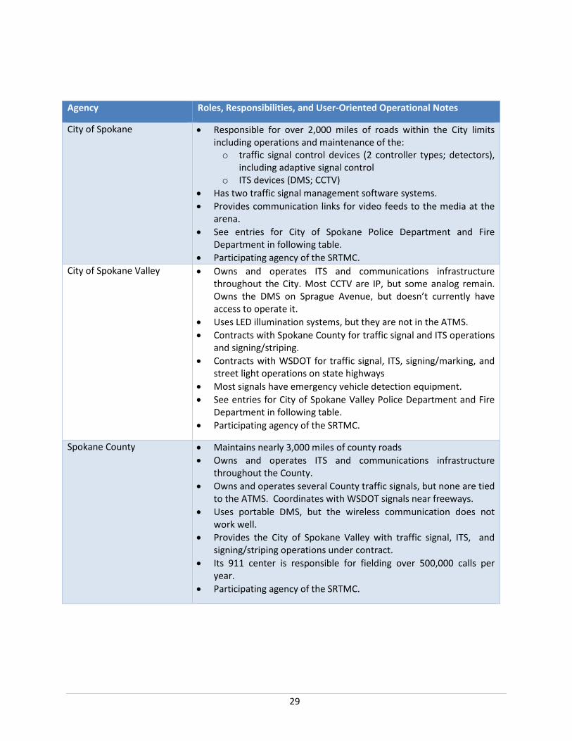
Table 7: Core Stakeholders with Roles and Responsibilities
Agency Roles, Responsibilities, and User-Oriented Operational Notes
Spokane Regional Transportation Management Center (SRTMC)
• Multi-jurisdictional control facility to enhance and support advanced transportation management capabilities.
• Provides 24/7 traffic management capabilities for the Spokane region.
• Monitor and control ITS field devices such as CCTV, DMS, and HAR. Analog CCTV are in ATMS, but IP CCTV are not.
• Support special event management and snow event management. • The six participating agencies on its board are included in the core
stakeholders.
WSDOT (Eastern Region) • Operates and maintains: o All ITS devices on I-90 and on State Routes across seven
counties. o Signals on limited access state facilities and in cities with
populations less than 22,500 o Signals have emergency vehicle preemption equipment
• Responsible for managing SRTMC. • Provides the City of Spokane Valley with traffic signal, ITS,
signing/marking, and street light maintenance and operations under contract.
• Uses LED illumination systems.
29
Agency Roles, Responsibilities, and User-Oriented Operational Notes
City of Spokane • Responsible for over 2,000 miles of roads within the City limits including operations and maintenance of the: o traffic signal control devices (2 controller types; detectors),
including adaptive signal control o ITS devices (DMS; CCTV)
• Has two traffic signal management software systems. • Provides communication links for video feeds to the media at the
arena. • See entries for City of Spokane Police Department and Fire
Department in following table. • Participating agency of the SRTMC.
City of Spokane Valley • Owns and operates ITS and communications infrastructure throughout the City. Most CCTV are IP, but some analog remain. Owns the DMS on Sprague Avenue, but doesn’t currently have access to operate it.
• Uses LED illumination systems, but they are not in the ATMS. • Contracts with Spokane County for traffic signal and ITS operations
and signing/striping. • Contracts with WSDOT for traffic signal, ITS, signing/marking, and
street light operations on state highways • Most signals have emergency vehicle detection equipment. • See entries for City of Spokane Valley Police Department and Fire
Department in following table. • Participating agency of the SRTMC.
Spokane County • Maintains nearly 3,000 miles of county roads • Owns and operates ITS and communications infrastructure
throughout the County. • Owns and operates several County traffic signals, but none are tied
to the ATMS. Coordinates with WSDOT signals near freeways. • Uses portable DMS, but the wireless communication does not
work well. • Provides the City of Spokane Valley with traffic signal, ITS, and
signing/striping operations under contract. • Its 911 center is responsible for fielding over 500,000 calls per
year. • Participating agency of the SRTMC.
30
Agency Roles, Responsibilities, and User-Oriented Operational Notes
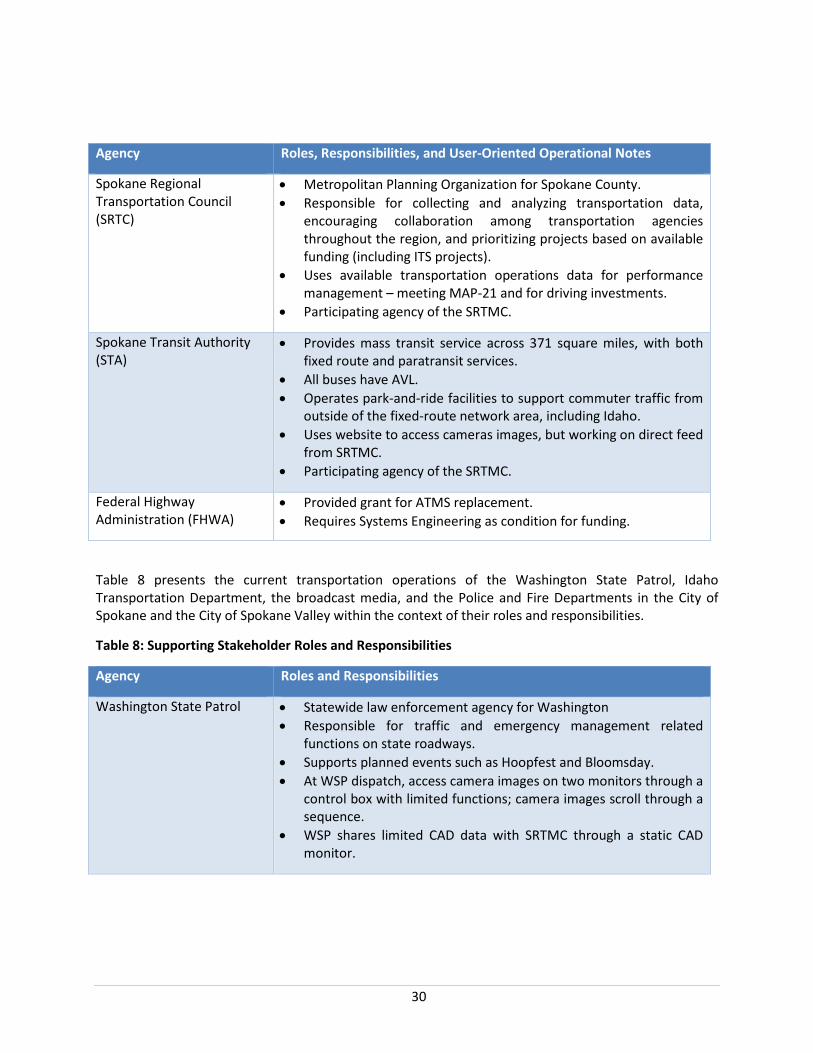
Spokane Regional Transportation Council (SRTC)
• Metropolitan Planning Organization for Spokane County. • Responsible for collecting and analyzing transportation data,
encouraging collaboration among transportation agencies throughout the region, and prioritizing projects based on available funding (including ITS projects).
• Uses available transportation operations data for performance management – meeting MAP-21 and for driving investments.
• Participating agency of the SRTMC.
Spokane Transit Authority (STA)
• Provides mass transit service across 371 square miles, with both fixed route and paratransit services.
• All buses have AVL. • Operates park-and-ride facilities to support commuter traffic from
outside of the fixed-route network area, including Idaho. • Uses website to access cameras images, but working on direct feed
from SRTMC. • Participating agency of the SRTMC.
Federal Highway Administration (FHWA)
• Provided grant for ATMS replacement. • Requires Systems Engineering as condition for funding.
Table 8 presents the current transportation operations of the Washington State Patrol, Idaho Transportation Department, the broadcast media, and the Police and Fire Departments in the City of Spokane and the City of Spokane Valley within the context of their roles and responsibilities.
Table 8: Supporting Stakeholder Roles and Responsibilities
Agency Roles and Responsibilities
Washington State Patrol • Statewide law enforcement agency for Washington • Responsible for traffic and emergency management related
functions on state roadways. • Supports planned events such as Hoopfest and Bloomsday. • At WSP dispatch, access camera images on two monitors through a
control box with limited functions; camera images scroll through a sequence.
• WSP shares limited CAD data with SRTMC through a static CAD monitor.
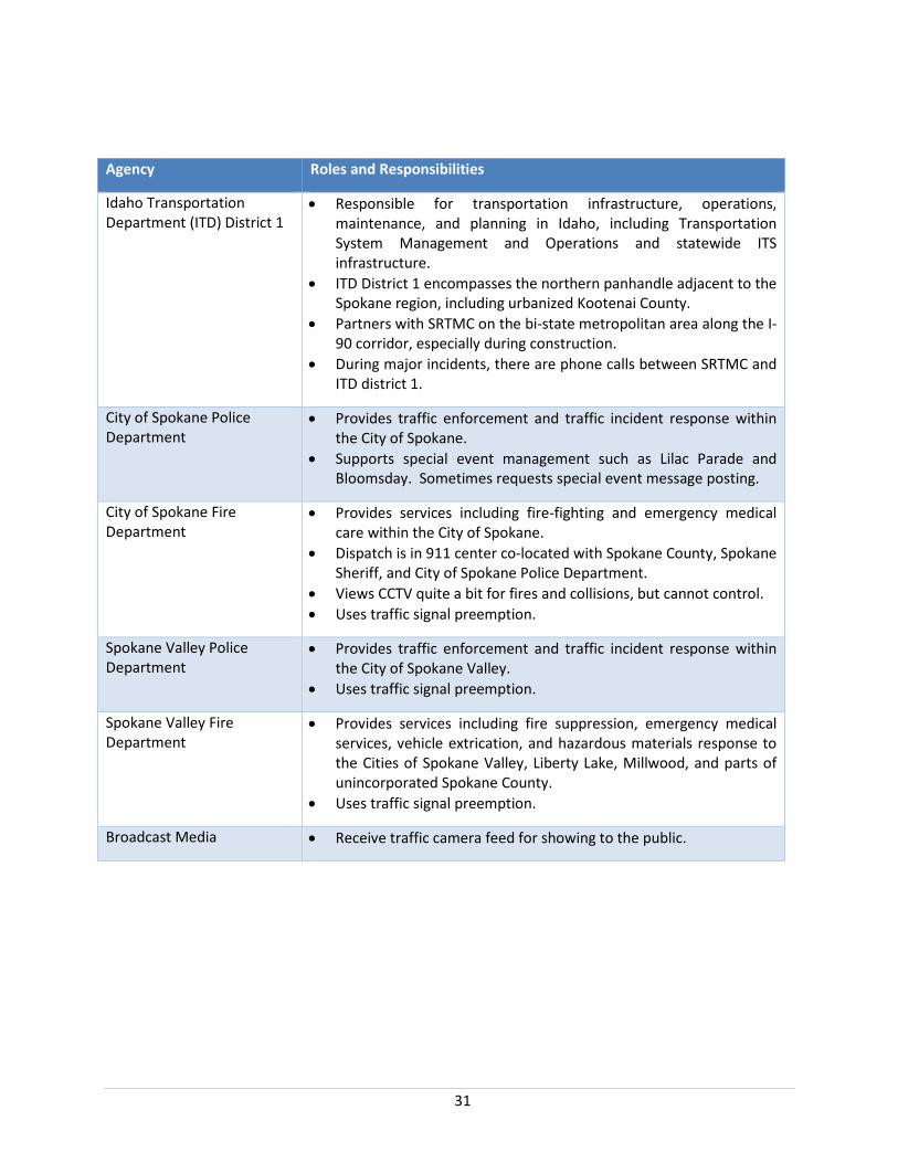
31
Agency Roles and Responsibilities
Idaho Transportation Department (ITD) District 1
• Responsible for transportation infrastructure, operations, maintenance, and planning in Idaho, including Transportation System Management and Operations and statewide ITS infrastructure.
• ITD District 1 encompasses the northern panhandle adjacent to the Spokane region, including urbanized Kootenai County.
• Partners with SRTMC on the bi-state metropolitan area along the I-90 corridor, especially during construction.
• During major incidents, there are phone calls between SRTMC and ITD district 1.
City of Spokane Police Department
• Provides traffic enforcement and traffic incident response within the City of Spokane.
• Supports special event management such as Lilac Parade and Bloomsday. Sometimes requests special event message posting.
City of Spokane Fire Department
• Provides services including fire-fighting and emergency medical care within the City of Spokane.
• Dispatch is in 911 center co-located with Spokane County, Spokane Sheriff, and City of Spokane Police Department.
• Views CCTV quite a bit for fires and collisions, but cannot control. • Uses traffic signal preemption.
Spokane Valley Police Department
• Provides traffic enforcement and traffic incident response within the City of Spokane Valley.
• Uses traffic signal preemption.
Spokane Valley Fire Department
• Provides services including fire suppression, emergency medical services, vehicle extrication, and hazardous materials response to the Cities of Spokane Valley, Liberty Lake, Millwood, and parts of unincorporated Spokane County.
• Uses traffic signal preemption.
Broadcast Media • Receive traffic camera feed for showing to the public.
32
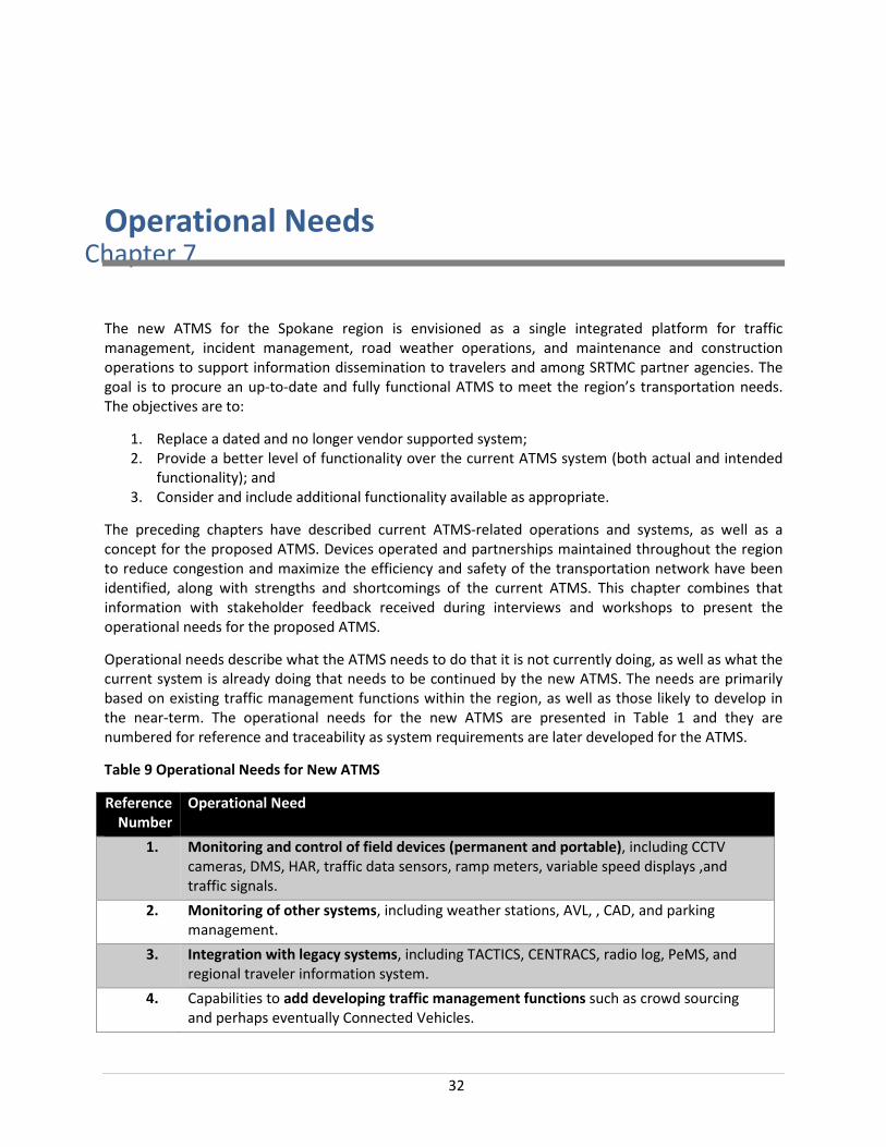
Chapter 7Operational Needs
The new ATMS for the Spokane region is envisioned as a single integrated platform for traffic management, incident management, road weather operations, and maintenance and construction operations to support information dissemination to travelers and among SRTMC partner agencies. The goal is to procure an up-to-date and fully functional ATMS to meet the region’s transportation needs. The objectives are to:
1. Replace a dated and no longer vendor supported system; 2. Provide a better level of functionality over the current ATMS system (both actual and intended
functionality); and 3. Consider and include additional functionality available as appropriate.
The preceding chapters have described current ATMS-related operations and systems, as well as a concept for the proposed ATMS. Devices operated and partnerships maintained throughout the region to reduce congestion and maximize the efficiency and safety of the transportation network have been identified, along with strengths and shortcomings of the current ATMS. This chapter combines that information with stakeholder feedback received during interviews and workshops to present the operational needs for the proposed ATMS.
Operational needs describe what the ATMS needs to do that it is not currently doing, as well as what the current system is already doing that needs to be continued by the new ATMS. The needs are primarily based on existing traffic management functions within the region, as well as those likely to develop in the near-term. The operational needs for the new ATMS are presented in Table 1 and they are numbered for reference and traceability as system requirements are later developed for the ATMS.
Table 9 Operational Needs for New ATMS
Reference Number
Operational Need
1. Monitoring and control of field devices (permanent and portable), including CCTV cameras, DMS, HAR, traffic data sensors, ramp meters, variable speed displays ,and traffic signals.
2. Monitoring of other systems, including weather stations, AVL, , CAD, and parking management.
3. Integration with legacy systems, including TACTICS, CENTRACS, radio log, PeMS, and regional traveler information system.
4. Capabilities to add developing traffic management functions such as crowd sourcing and perhaps eventually Connected Vehicles.
33
5. Automated incident detection and alerts based on pre-established thresholds. 6. Adjustable thresholds for automated functions by time of day, day of week, and time of
year. 7. Recommended action plans based on common types of incidents. 8. Incident logging to record incidents, operator actions and device status. 9. Capabilities to support backup center operations for SRTMC. 10. Multiple levels of permission to support the varieties of user access required among
SRTMC partner agencies. 11. View users logged into system and their activities. 12. Instant messaging capability among users while logged into system. 13. Capabilities to support standardization of operational procedures throughout the
region. 14. Digital maps of traffic flow, active incidents, field device locations and status, and
detour routes for user interface. 15. Tailored user interface upon login based on established user preferences. 16. Tailored alert filters based on established user preferences. 17. Access to real-time and historical data (e.g. volume, speed, occupancy, incident records)
for regional planning. 18. Basic data analytics for performance management. 19. System diagnostics to confirm communication and operations with field devices and
other systems.
34
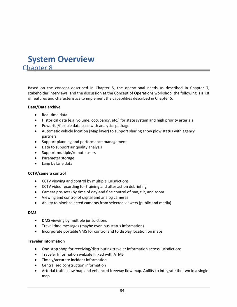
Chapter 8System Overview
Based on the concept described in Chapter 5, the operational needs as described in Chapter 7, stakeholder interviews, and the discussion at the Concept of Operations workshop, the following is a list of features and characteristics to implement the capabilities described in Chapter 5.
Data/Data archive
• Real-time data • Historical data (e.g. volume, occupancy, etc.) for state system and high priority arterials • Powerful/flexible data base with analytics package • Automatic vehicle location (Map layer) to support sharing snow plow status with agency
partners • Support planning and performance management • Data to support air quality analysis • Support multiple/remote users • Parameter storage • Lane by lane data
CCTV/camera control
• CCTV viewing and control by multiple jurisdictions • CCTV video recording for training and after action debriefing • Camera pre-sets (by time of day)and fine control of pan, tilt, and zoom • Viewing and control of digital and analog cameras • Ability to block selected cameras from selected viewers (public and media)
DMS
• DMS viewing by multiple jurisdictions • Travel time messages (maybe even bus status information) • Incorporate portable VMS for control and to display location on maps
Traveler Information
• One-stop shop for receiving/distributing traveler information across jurisdictions • Traveler Information website linked with ATMS • Timely/accurate incident information • Centralized construction information • Arterial traffic flow map and enhanced freeway flow map. Ability to integrate the two in a single
map.
35
• Tailored information for freight • Parking information
Traffic management
• Traffic signal coordination/control (interface with TACTICS and CENTRACS, interface with adaptive control)
• Compatible with transit signal priority • Ramp metering • Variable speed displays/control (ATM) • Lane use control
Traffic incident management / event management / emergency management
• Action or incident management plans • Improved operator traffic incident management capabilities • Highway advisory radio control • Support response and detour planning • Integration with enforcement computer aided dispatch • Incident detection
Operator/user displays and support
• Map of resource (e.g. CCTV, DMS, etc.) locations that show status of devices • Digital maps • Alert features • Permissions and settings by user, time of day • Multiple camera images displayed on each desktop • Improved integration with and control of video wall • Set thresholds by time of day • Tailored operator windows by operator login • Action logging • Integrated workstation • Ability to efficiently handle multiple events simultaneously • System diagnostics
Integration with other systems
• ITD • Center-to-center capabilities • Freeway/arterial integration • CVO/CVSN data
These features will be described in an operational context in the scenarios presented in Chapter 11.
36
Chapter 9Operational Environment
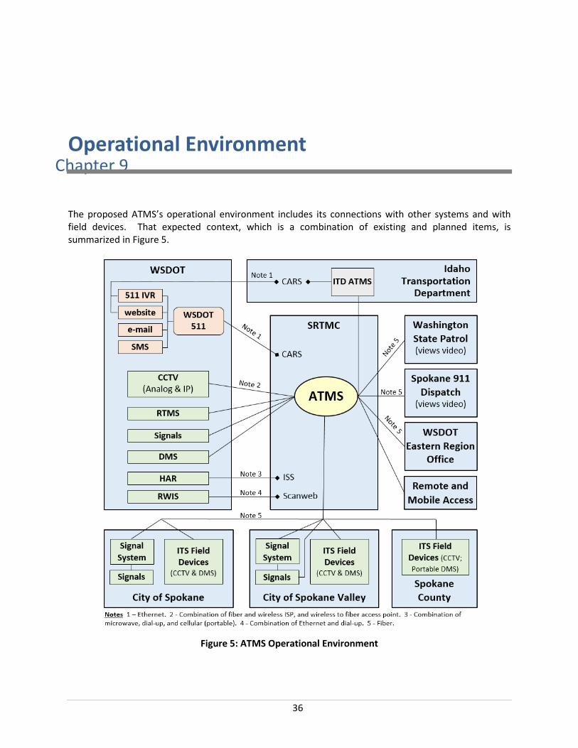
The proposed ATMS’s operational environment includes its connections with other systems and with field devices. That expected context, which is a combination of existing and planned items, is summarized in Figure 5.
Figure 5: ATMS Operational Environment
37
As shown, the ATMS is envisioned to be the platform for much, but not all, of the control, monitoring, and data exchange among ITS field devices, traffic signals, traffic signal systems, and regional agencies. The field devices, traffic signals, and traffic signal systems are owned and operated by a variety of stakeholders as described in Chapter 6.
The ATMS is expected to have center-to-field (C2F) connections with both analog and IP CCTV, remote traffic microwave systems (RTMS), traffic signals, and DMS. The C2F communications network includes significant fiber optic cable as well as twisted pair copper interconnect, wireless communications, and leased line services.
The ATMS is expected to have center-to-center (C2C) software interfaces with traffic signal systems as well as with the ITD ATMS. In addition, select functionality of the ATMS will be available from the offices of regional partners. There is fiber among many of the agency sites, including SRTMC, WSDOT Eastern Region Offices, City of Spokane, City of Spokane Valley, Spokane County, Spokane County 9-1-1, WSP, and the Spokane Emergency Operations Center (EOC). Gaps that need to be filled include to STA and ITD District 1 headquarters.
The 2013 Spokane Region Intelligent Transportation System Plan recorded a stakeholder need for developing formal agreements to document responsibilities, service level expectations, and funding for shared fiber optic networking.
The proposed ATMS will also be accessed by remote and mobile users. Capabilities will vary by user, but it is expected that agencies such as STRC, STA, and the cities of Spokane and Spokane Valley will access the ATMS directly. Also, staff from police and fire departments may access video and other information using tablets.
38
Chapter 10Support Environment
The support environment for the ATMS includes the physical facilities, existing and proposed staffing concept, and other components that enable its ongoing functions.
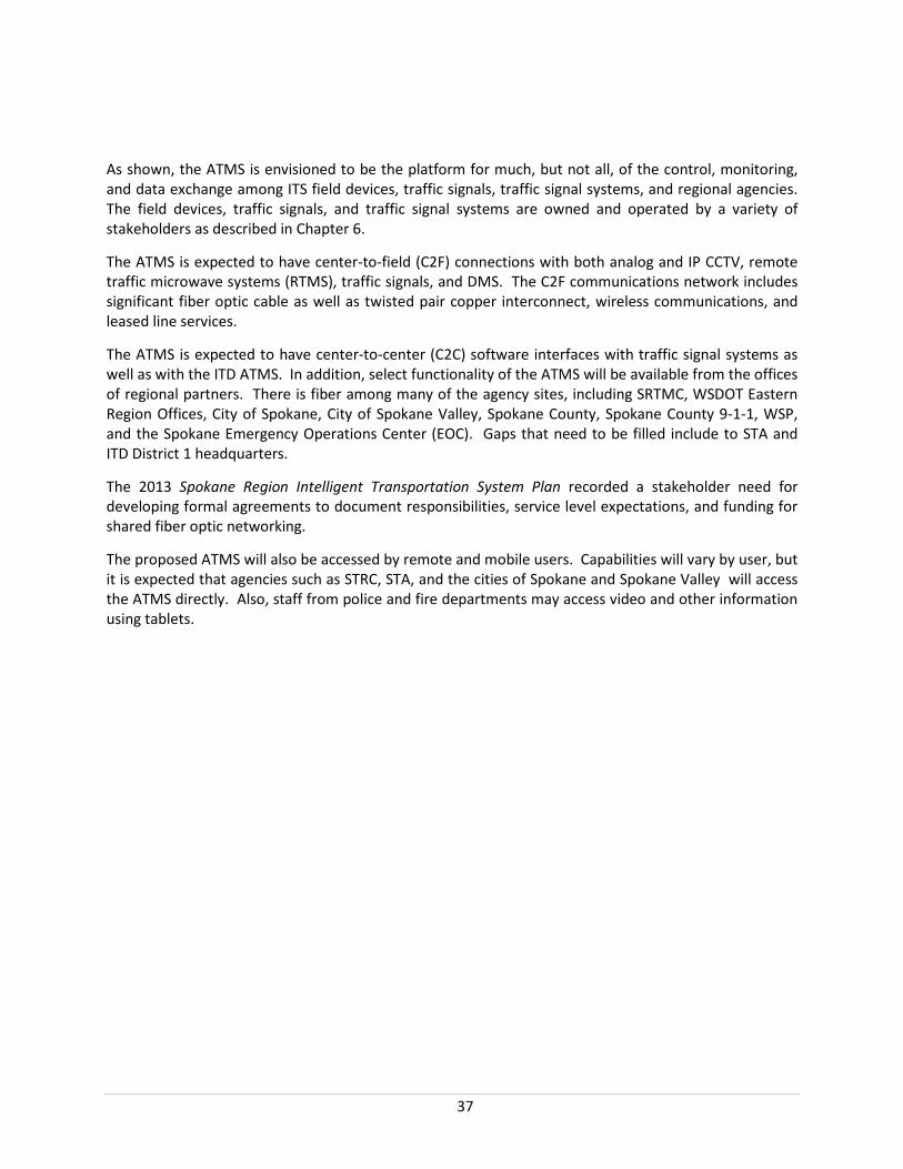
The ATMS will primarily be used by the operators at the SRTMC, currently a 900 square foot facility currently at the Spokane Intermodal Center. The SRTMC includes four operator workstations, a video wall, and a communications room. Figure 6, from the Spokane Region ITS Plan, shows part of the SRTMC.
Figure 6: SRTMC
The SRTMC is staffed 24/7. During the AM and PM peaks, there are two operators and one supervisor. At other times, there is one operator and one supervisor. There is also a TMC manager. At this time, it is not expected that replacing the ATMS will require additional staff. However, as more field devices and functions are added, there may be a need for additional staff. Once the ATMS system is selected, a staffing plan will be developed.
The 2013 Spokane Region ITS Plan recorded a stakeholder need for allocating resources for:
• Information technology (IT) support and software development • Engineering/ operations/ planning capabilities, such as project development coordination • On-call traffic safety systems operator (TSSO) • Public information officer (PIO) to support traveler information
The SRTMC is overseen by a board of its members that is responsible for planning, operations, and budgeting. In 2013, the approximate breakdown of funding sources for operations was reported as follows: 60% - grants (e.g. CMAQ, legislative ITS project earmarks), 30% - WSDOT, 5% SRTC, and 1% from each county, city, and the STA. The need for a stable funding stream for SRTMC was documented in the 2013 Spokane Region ITS Plan.

39
WSDOT is responsible for maintaining the ATMS itself. The Spokane Region Intelligent Transportation System Plan noted that written agreement should be developed for equipment management and maintenance at SRTMC. Responsibility for maintaining ITS field devices and communications network components is retained by the item’s owner, though the owner can contract with another entity to do the actual maintenance.

40
Chapter 11Operational Scenarios
This section presents scenarios to describe how the ATMS is expected to operate under a variety of conditions. Each scenario describes a sequence of events and activities carried out by the user, the system, and the environment. It specifies what triggers the sequence, who or what performs each step, communications (when, what is communicated and to whom). The scenarios cover normal operations, operation during roadway construction projects, traffic incidents, special events, data archiving, and differences in operations during winter conditions. The scenarios are based on the features presented in Chapter 8, the stakeholder interviews, and the discussions during the Concept of Operations workshop.
11.1. Normal Operations – No events, No incidents In this scenario, there are no major events or major traffic incidents.
Prior to the AM peak the operator logs into her workstation and notices that her permissions, settings, and windows were automatically loaded. She checks the status page and sees that there are no active incidents being managed. This is what she had expected, because she did not receive any alerts that morning. She also notices that a construction work zone is planned to begin at 9:30 AM. She checks the alarms page in the ATMS and sees that that no devices (e.g. CCTV, DMS, etc.) have alarms. Next, she checks the device map view and sees that all devices are communicating normally. All maps in the system are dynamic and GIS based so the operators can scroll and zoom dynamically.
She sees that the cameras have moved to the pre-sets that give the views she wants during AM peak. At one location, as she is checking the cameras, she zooms in to get a view of a disabled vehicle. The camera control allows fine, responsive control to zoom, pan, and tilt to view the scene to her satisfaction. Both analog and digital/IP cameras can be viewed and controlled. The video wall is displaying the rotation of camera images that she has set for the AM peak period. She also notices that the Washington State Patrol (WSP) and City of Spokane are logged into the system. She sends a text message through the ATMS to WSP to check the status of the communications link. She receives a text message back.
As the AM peak, the operators keep an eye on the traffic map and check cameras periodically. The map displays color-coded speeds on I-90 and major arterials. The operator assigned ramp metering operations notices that westbound meters in the Valley are starting up. The ATMS automatically turns on ramp meters when conditions warrant.
The operator notices that as congestion builds and speeds slow, the variable speed system reacts accordingly, providing a safe speed for drivers so they can comfortably slow down to match the speeds of the downstream traffic.
41
Because there are no incidents, the DMS on I-90 are displaying travel times. The operator checks the website to make sure it is displaying the same information she is seeing on the traffic map and the DMS signs. (The website displays the DMS messages.)
The operator notices that the City of Spokane entered a message regarding a collision on Monroe St. She displays the City of Spokane camera nearest collision and sees no significant backup or problem. She starts to move the camera view when the control of the camera is taken over by a City employee - priority is assigned to users when two users want a different camera view at the same time. In this instance, the owner of the camera is set to have priority.
The operator checks the freight information site and notices the notification of upcoming construction that includes over-sized restrictions on Division.
A City of Spokane signal tech is planning to check AM Peak timing patterns to see if they need updating. He checks from his office on the TACTICS system to make sure it is operating the correct timing plan. He checks with the ATMS CCTV images to gauge traffic flow at several locations along Maple. He selects a pre-set to turn the camera 180 degrees. After seeing the traffic flow, he decides to go to the field to verify signal operations.
While in the field, the signal tech notices the timing seems to be different than he expected and traffic is not flowing smoothly. He receives an alert that the bus priority system was activated. He looks downstream and sees the bus on its way. He logs into the ATMS wirelessly from his tablet and views camera images downstream. He notices that other intersections were not as disrupted as the one he started at. He also notices that the ATMS displays the correct timing plan.
At 9:30, the resurfacing project on Ruby/Division from Indiana to Bridgeport gets underway. The activity today will be pavement milling northbound. The construction office has portable DMS placed to warn motorists of the work zone and lane closures. Portable radar detection is also in place (loops will be milled out) to measure traffic speeds.
The SRTMC operator verifies that the wireless connection to portable DMS is working. The portable DMS shows in the correct location on the device map. The operator displays images from portable cameras at the intersections of Ruby & Indiana and Ruby & Desmet and sees that traffic is moving smoothly. The portable cameras are used to monitor back of queue.
The construction office calls to say that traffic control for the work zone is starting. The operator changes status of the construction event in the ATMS to active. The ATMS activates the portable DMS message and I-90 DMS message. The ATMS also activates the HAR station in the area with the pre-recorded message for this construction project. ATMS updates are sent to partner agencies to let them know construction is starting. The ATMS automatically updates information sent to the website. The operator verifies that the correct information is displayed on the website. The ATMS sends out subscription alerts sent via social media and e-mail.
As the construction project continues, the operator monitors the traffic map and cameras along Division and Ruby. He verifies that data from the new detection devices display on the map and the map accurately shows conditions. As the queue extends farther south, the operator updates the portable and fixed DMS messages. He also verifies that the website notices are updated as appropriate through the ATMS.
42
The City of Spokane operations staff monitor the situation through the ATMS link using cameras and the traffic map. They also view DMS messages. If signal plans or timing parameters need adjusting, they will adjust through their TACTICS system.
As the construction activities wind down for the day, the construction office calls the SRTMC to notify them that traffic control is being torn down. The operator updates the construction event status to inactive and verifies that the website messages update automatically. The ATMS checks status of portable DMS and blanks it because the power is still on. The ATMS removes the construction message from the I-90 DMS and deactivates the HAR station.
11.2. Major Traffic Incident This scenario describes how SRTMC partner agencies will likely use the proposed ATMS to manage a major traffic incident within the region. The incident occurs on a normal spring morning at 7:16 AM during the rush hour. It is a major crash involving a commercial vehicle and two passenger vehicles. The crash happens on I-90 westbound, just east of exit 289 (Pines Rd/Hwy 27). The crash has restricted I-90 to only one lane of traffic and the restriction is expected to last several hours while the crash is investigated. Travelers are expected to begin diverting along Sprague Ave and Hwy 290 to avoid the congestion.
The incident is initially detected by the Regional 911 center as several cellular 911 calls report the crash. Because the incident is on I-90 and may involve injuries, City of Spokane Valley Fire and WSP dispatch are notified. All three agencies access cameras at Evergreen Road and Pines Road at their workstations. WSP dispatch selects camera pre-sets to confirm crash details and enters information into CAD. The WSP CAD data feed automatically generates an alert for the SRTMC operator regarding the crash. Meanwhile, WSP dispatch calls the SRTMC operator to request traffic control for I-90 and confirms the crash will likely close I-90 for several hours while a commercial vehicle crash investigation occurs.
Prior to receiving the alert and call from WSP, the SRTMC operator is at their work station, logged in and monitoring traffic via camera pre-sets established for the morning rush hour. Several camera views are displayed at work station and the SRTMC operator notices camera zoom levels at Evergreen Rd and Pines Rd are being adjusted. Upon further review, the SRTMC operator sees traffic queuing and three vehicles involved in a crash. The SRTMC operator receives the initial, automated alert generated by WSP CAD with crash details. After receiving the call from WSP dispatch, the SRTMC operator adds details to the event management screen. As traffic builds before the crash scene and significantly drops off after, the SRTMC operator receives a second automated alert generated by the traffic data sensors.
Following confirmation of initial alerts, information is immediately pushed to the traveler information web site, social media, telephone and email alert services. The freeway/arterial traffic flow map is updated based on changing volumes on I-90, Sprague Ave and Hwy 290 and additional alerts are pushed to City of Spokane Valley and ITD. Variable speed limit signs and ramp meters are automatically activated also based on the changing volumes on I-90. After placing calls to the City of Spokane Valley and ITD to coordinate traveler information and verify the pre-approved I-90 detour route to support traffic control requested by WSP, the SRTMC operator references the recommended action plan for crashes involving commercial vehicles. The action plan recommends a series of further actions for managing this type of incident and is intended to improve operator TIM capabilities and consistency.
43
The SRTMC operator sees that there are injuries and camera images are very graphic. Following the recommended action plan, the operator blocks public and media viewing for Pines Road and Evergreen Road cameras. The SRTMC operator next dispatches WSDOT incident response vehicles to assist with scene management and traffic control, and then monitors their approach to crash scene using AVL. WSP also monitors the WSDOT incident response vehicles approach the crash and begin to implement the requested traffic control. Westbound DMS east of the queue and eastbound DMS west of the crash scene are activated by the SRTMC operator, replacing the routine travel time messages with incident messages. The SRTMC operator then activates lane use signs to indicate which lanes blocked. Next, the SRTMC operator activates the HAR stations at Liberty Lake and ID/WA border.
Just before receiving the call from SRTMC, the City of Spokane Valley operations staff receive an initial alert at their work station generated by the SRTMC operator verifying initial, automated alerts from CAD and queue detection. The City of Spokane Valley operations staff view cameras at Evergreen Rd and Pines Road to see traffic building on I-90. They also view cameras on Appleway Boulevard at University Road, Dishman Road and Park Road to see if and how diverting traffic is building along Sprague Ave. Meanwhile, the City of Spokane Valley operations staff receives the call from SRTMC operator and the mutually verify the pre-approved I-90 detour route. In response, the City of Spokane Valley operations staff activate a modified signal timing plan along Sprague Avenue to accommodate the increased traffic. It is important to note here that if the SRTMC operator could not reach the City operations staff, the SRTMC operator has the authority to select the pre-determined signal timing plan for an incident on I-90 in this vicinity.
Similarly, the ITD State Communications Center dispatcher also receives an initial alert at their work station generated by the SRTMC operator confirmation of initial, automated alerts from CAD and queue detection. After receiving a call from the SRTMC operator to coordinate traveler information, the ITD State Communications Center dispatcher activates DMS on I-90 westbound in Coeur d’Alene to alert morning commuters of the blocked lanes and delay. The ITD State Communications Center dispatcher is also able to view the other I-90 westbound DMS in the Spokane region.
As the crash investigation concludes several hours later, WSDOT maintenance and private tow companies clear the roadway. The SRTMC operator updates traveler information and alerts to City of Spokane Valley and ITD. The City of Spokane Valley changes the signal timing plan along Sprague Ave back to normal for that time of day, ITD removes incident messages from the Coeur d’Alene DMS. A record of the incident is maintained for performance management and for incident debriefing at a later date and time.
11.3. Major Planned Special Event (like Bloomsday) This scenario describes how the proposed ATMS will be used by SRTMC partner agencies to manage a major planned special event within the region. The event is Bloomsday, an annual race held that has been held each year since 1977. The 40th race will be held April 29-May 1, 2016. The 12 km (7.46 m) course runs along local streets north of I-90 between Division St and Hwy 195. Pre-race events will take place on Friday and Saturday, and the race begins at 9:00 AM on Sunday. Several local streets are closed for the race course and increased traffic is expected on other roadways, including I-90, as people access the designated event area.

44
Several months prior to the event, the City of Spokane operations staff and law enforcement work with Bloomsday event coordinators to determine designated parking areas, necessary road closures, modified signal timing plan, and other traffic control required to manage transportation. From those conversations, the City of Spokane operations staff develop an event management plan. The plan is reviewed with SRTMC, WSP, STA and ITD. During the review meeting, agencies identify cameras, DMS (permanent and portable), HAR and other traveler information services available to support event management. Additional traffic control and enforcement of I-90, daily bus route changes, and temporary park and ride/shuttle services are also identified and added to the plan.
A few weeks prior to Bloomsday, the City of Spokane operations staff develop and enter modified signal timing plans at their work station based on the event management plan. The SRTMC operator also enters event parameters into system based on the event management plan; creating messages and setting activation thresholds for cameras, DMS (permanent and portable), HAR and other traveler information services targeted to support event management.
On Friday before the race, the City of Spokane operations staff and law enforcement reference the event management plan at their work stations to confirm pre-planned, modified signal timing plans. City of Spokane operations staff confirms placement of portable cameras and DMS on local streets, and then activates viewing pre-sets and planned messages. The SRTMC operator references event management plan at their work station to confirm pre-planned messages and thresholds for field devices and traveler information. Upon activation, information is immediately pushed to the traveler information web site, social media, telephone and email alert services. The freeway/arterial traffic flow map is updated automatically throughout the day as traffic patterns anticipated for the event come into play. Event messages are posted to DMS and HAR. If congestion forms on I-90, variable speed limit signs are automatically activated and updated as traffic queues build on I-90.
Once the event parameters are activated alerts are pushed to WSP, STA, City of Spokane Valley and ITD. Staff at these locations periodically view cameras, DMS messages and the freeway/arterial traffic flow map at their work stations to monitor traffic. Pan/tilt/zoom camera features are used throughout the event to monitor specific traffic details as needed.
11.4. Data Archiving and Retrieval The operational scenario for data archiving and retrieval was in the form of e-mails from stakeholders to the SRTMC Supervisor illustrating various data availability issues. The scenario also provided a basis for response derived from assumptions on the proposed ATMS system. Each topic within the scenario was intended as a springboard to verifying the assumed capabilities and prompt discussion on related needs and issues. Table 10 presents the data archiving topic and the desired response of the system to the topic.
Table 10: Data Archiving and Retrieval Scenario Components
Topic E-Mail Inbox Message, Basis for Response, and Additional Comments from Stakeholders

45
Topic E-Mail Inbox Message, Basis for Response, and Additional Comments from Stakeholders
Cong
estio
n Re
port
Inbox: Can you generate last month’s congestion report including hourly delay and travel time reliability for state system and high priority arterials, the top 10 hot spots and trends in congestion over the past three years, and information on reliability of truck freight movements?
Response: Yes, we’ll produce from the lane-by-lane freeway and priority arterial volume and occupancy data. Using our database and analytical software, one of our operators can compile the info within a few days. Comments: None
Clea
ranc
e Ti
mes
; M
ergi
ng D
ata
from
old
ATM
S
Inbox: You and your staff did good work on today’s I-90 truck incident. How does the clearance time compare to our average for truck incidents over the past year? How is our overall incident clearance time trending since we first started recording that data? Response: Yes, we can determine the recent information from the data in the ATMS. Data from before the new ATMS software is archived separately, but still available. Comments: • Incident response data – would need to keep the old system running for a period of
time or ingest the data into the new ATMS. • May not be easy to go back to data prior to the new ATMS – e.g. keyword search over
two different systems. • Classification of vehicles – can ATMS database keep incidents by separate vehicle
class? • Is there a technology for detection to separate commercial vs. passenger vehicles
involved in incidents? Can get 4-bin classification fairly easily, but full range of truck classifications may not be as easy. A checkbox for commercial vehicle involved may be the level of detail possible.
Arch
ived
Vid
eo
Inbox: WSP requests video of today’s truck crash for their investigation. Response: WSDOT’s policy is not to record video so none is available. Comments: • WSDOT does not record/archive video; other jurisdictions may have their own
policies. • May consider recording and keeping for a short period and overwrite video. • STA currently records 14 days on the DVR – not considered an obtainable record
until/unless the video is pulled by STA for a report. • There is time to discuss – project will take about 1 year. • Need to have capability of recording/storing video – jurisdictions can decide policy
later.
Afte
r-ac
tion
Revi
ew
Inbox: We need to set up an after action review for today’s truck incident. What information could you bring? Response: ATMS: Volume/ speed/ occupancy pre-crash through return to normal conditions; log of operator actions including DMS messages and requests for emergency responders; incident log CAD: record of initial crash report; record of dispatched emergency responders.

46
Topic E-Mail Inbox Message, Basis for Response, and Additional Comments from Stakeholders
Comments: None
Sign
al T
imin
g Inbox: City of Spokane Police are investigating a crash at Maple and Broadway. Please share signal timing records, especially if the signal was in flash, had any alarms, and if the signal timing/phasing had recently been changed. Response: ATMS interface to TACTICS does not have this information. However, the SRTMC operator refers to City of Spokane operations staff for their follow up. Comments: None
Inci
dent
St
atis
tics Inbox: For a technical society presentation, there is a request for an updated version of a
figure showing number of incidents by month and the breakdown of incident types. Response: ATMS has information readily available. Comments: • None
Auto
mat
ic V
ehic
le L
ocat
ion
Inbox: A contact for WSDOT’s automated vehicle location (AVL) program says that AVL information is available for snow plows and speaking with her counterpart at Spokane Transit she knows that their bus AVL data is also available. Would it be of use and could your ATMS accept it? Response: Yes, WSP sometimes calls in snow accumulations so it would be helpful to know if plows, salters, or sanders are approaching. We don’t see a need for the real-time transit vehicle locations, but if we had the archived data, it would be available for a variety of planning purposes, especially in conjunction with signal timing volume data. Our ATMS can accept real-time data in XML format and will archive it in database. We can work out details. Comments: • What type of AVL data would be good to see real time? Selectable layers by agency.
E.g. event with STA bus approaching – TMC operator can contact STA and ask to verify.
• What type of AVL data would be good to archive? None in ATMS – AVL systems already archives.
• ATMS could intake STA data for load/capacity and on/behind schedule for use in preemption. (On-bus info goes into Opticom controller.)
Devi
ce U
ptim
e Inbox: A researcher for an FHWA study is requesting information on the uptime of various types of ITS devices and communications infrastructures. Is data available? Response: Yes, uptimes are tracked per device and the network connectivity is as well. From previous use of the data, we also know differences in reliability among manufacturers and by age of equipment. Comments: None
Rem
ote
Acce
ss
to D
atab
ase Inbox: The Spokane Regional Transportation Council has a project on correlating
congestion, air quality, and weather. What information can SRTMC contribute? Can their staff be trained to use the databases and access them for their offices? Response: Have data for congestion measures (volume/ speed/ occupancy/ delay) in same database. Yes, can give staff logins to system with archived data permissions and train them. They can use the web-interface. Multiple users can access the database at

47
Topic E-Mail Inbox Message, Basis for Response, and Additional Comments from Stakeholders
the same time. Comments: None
Gen
eral
Additional Comment: • Ability to measure the effect of a given action on traffic flow is desired.
11.5. Winter Operations Some of the operations noted in these scenarios could differ under winter weather conditions. The following are features of the system that will enhance winter weather operations.
• Automatic vehicle location information from snowplows will be fed to the ATMS to allow agencies to view where snowplows are located.
• The ATMS will have the ability for different CCTV camera pre-sets in the winter. • The ATMS will have the capability to have a winter DMS message library. • The ATMS will have the ability to deploy pre-planned winter timing plan action sets.
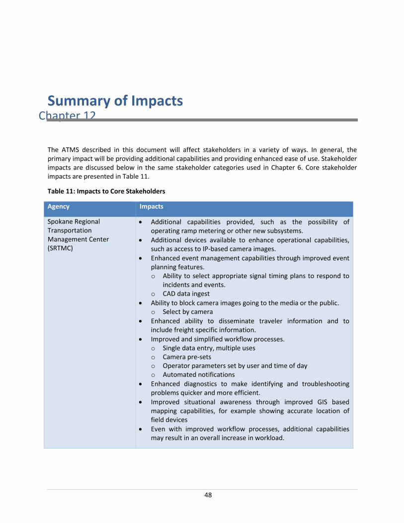
48
Chapter 12Summary of Impacts
The ATMS described in this document will affect stakeholders in a variety of ways. In general, the primary impact will be providing additional capabilities and providing enhanced ease of use. Stakeholder impacts are discussed below in the same stakeholder categories used in Chapter 6. Core stakeholder impacts are presented in Table 11.
Table 11: Impacts to Core Stakeholders
Agency Impacts
Spokane Regional Transportation Management Center (SRTMC)
• Additional capabilities provided, such as the possibility of operating ramp metering or other new subsystems.
• Additional devices available to enhance operational capabilities, such as access to IP-based camera images.
• Enhanced event management capabilities through improved event planning features. o Ability to select appropriate signal timing plans to respond to
incidents and events. o CAD data ingest
• Ability to block camera images going to the media or the public. o Select by camera
• Enhanced ability to disseminate traveler information and to include freight specific information.
• Improved and simplified workflow processes. o Single data entry, multiple uses o Camera pre-sets o Operator parameters set by user and time of day o Automated notifications
• Enhanced diagnostics to make identifying and troubleshooting problems quicker and more efficient.
• Improved situational awareness through improved GIS based mapping capabilities, for example showing accurate location of field devices
• Even with improved workflow processes, additional capabilities may result in an overall increase in workload.

49
Agency Impacts
WSDOT (Eastern Region) • Improved performance management capabilities. • Additional traffic management capabilities, such as ramp metering,
variable speed control, and lane use control. • Improved situational awareness through improved GIS based
mapping capabilities, for example show showing accurate location of field devices
• Ability to control WSDOT signals through a single ATMS platform making signal operations and maintenance more efficient.
• Enhanced data sharing, archiving, and analytics. • Ability to work with other WSDOT TMC’s. • Improved incident and event management capabilities
o Incident and event management plans o Ability to determine location of and communicate with
portable DMS o Lane use control and variable speed control
• Improved work zone traffic control. o Ability to determine location of and communicate with
portable DMS o Lane use control and variable speed control
City of Spokane • Enhanced remote access to the ATMS • Improved center-to-center connection from the City’s traffic signal
systems to the ATMS. This will allow for enhanced data sharing, archiving, and analytics.
• Improved situational awareness through improved mapping capabilities to show field devices
City of Spokane Valley • Enhanced remote access to the ATMS • Improved center-to-center connection from the City’s traffic signal
systems to the ATMS. This will allow for enhanced data sharing, archiving, and analytics.
• Data archive and remote access to historical data to improve performance management capabilities.
Spokane County • Enhanced remote access to the ATMS • Data archive and remote access to historical data to will improve
performance management capabilities. This will allow for enhanced data sharing, archiving, and analytics.
• Improved situational awareness through improved mapping capabilities to show field devices
Spokane Regional Transportation Council (SRTC)
• Improved ability to collect and analyze data for planning and performance management purposes through the data archive and analytics features.

50
Agency Impacts
Spokane Transit Authority (STA)
• Enhanced remote access to the ATMS • Enhanced data sharing, archiving, and analytics. • Data archive and remote access will provide access to historical
data to improve route planning and route detours.
Federal Highway Administration (FHWA)
• Provide enhanced performance measurement capabilities so agencies can more easily comply with MAP 21 requirements.
Table 12 presents the anticipated impacts to supporting stakeholders.
Table 12: Supporting Stakeholder Impacts
Agency Impacts
Washington State Patrol • Enhanced camera access with ability to access IP camera images.
• Enhanced remote access to the ATMS. o Provides access to data archive and analytics package
• Improved situational awareness through improved mapping capabilities to show field devices
Idaho Transportation Department (ITD) District 1
• Center to center capabilities will provide more information on conditions and actions on the Washington side of the border.
• Enhanced capabilities to coordinate actions for events that affect conditions on both sides of the border.
• Improved situational awareness through improved mapping capabilities to show field devices in the Spokane region.
City of Spokane Police Department
• Enhanced camera access with ability to access IP camera images. • Enhanced remote access to the ATMS.
o Provides access to data archive and analytics package • Data archive and remote access will provide access to historical
data to improve response route planning and event management. • Improved situational awareness through improved mapping
capabilities to show field devices
City of Spokane Fire Department
• Enhanced camera access with ability to access IP camera images. • Enhanced remote access to the ATMS.
o Provides access to data archive and analytics package • Data archive and remote access will provide access to historical
data to improve response route planning and event management.

51
Agency Impacts
Spokane Valley Police Department
• Enhanced camera access with ability to access IP camera images. • Enhanced remote access to the ATMS.
o Provides access to data archive and analytics package • Data archive and remote access will provide access to historical
data to improve response route planning and event management. • Improved situational awareness through improved mapping
capabilities to show field devices
Spokane Valley Fire Department
• Enhanced camera access with ability to access IP camera images. • Enhanced remote access to the ATMS.
o Provides access to data archive and analytics package • Data archive and remote access will provide access historical to
data to improve response route planning and event management.
Broadcast Media • Improved access to camera images o Access IP-based camera images


