29
© 2014 HDR, Inc., all rights reserved. Diablo Dam: Drone Survey ADVANCED VEGETATION MANAGEMENT TECHNIQUES AND TOOLS

© 2014 HDR, Inc., all rights reserved.
Diablo Dam: Drone Survey
ADVANCED VEGETATION MANAGEMENT TECHNIQUES AND TOOLS

Today – It is easier than ever to collect vast amounts of high-quality survey grade data through LIDAR acquisition.
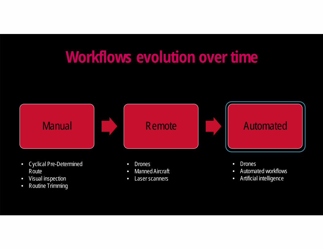
Manual Remote Automated
• Cyclical Pre-Determined Route
• Visual inspection• Routine Trimming
• Drones• Manned Aircraft• Laser scanners
• Drones• Automated workflows• Artificial intelligence
Workflows evolution over time

Objective is to turn data into actionable decisions
Data
Knowledge
DecisionsActions

LiDAR (Light Detection and Ranging) Rapidly sends out pulses of laser and then
measures the time of return to generate x,y,zvalues for point cloud creation.
Results in billions of points and a high resolution model of current conditions
Requires large areas for storage of big data sets.
Processing/Classifying is required after collection for optimal use.
LiDAR Data
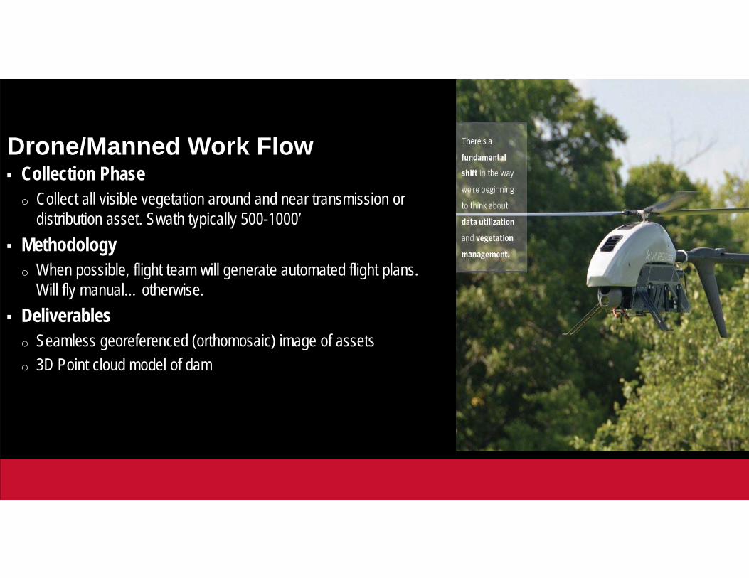
Collection Phaseo Collect all visible vegetation around and near transmission or
distribution asset. Swath typically 500-1000’ Methodology
o When possible, flight team will generate automated flight plans. Will fly manual… otherwise.
Deliverableso Seamless georeferenced (orthomosaic) image of assetso 3D Point cloud model of dam
Drone/Manned Work Flow

AVAILABLE SENSORS
• RGB – Standard Cameras• LiDAR• Multi/Hyperspectral Imaging• Thermal
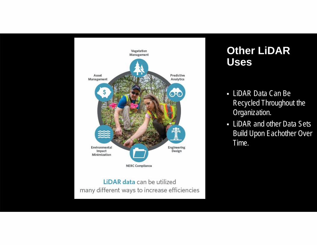
LiDAR Data Can Be Recycled Throughout the Organization.
LiDAR and other Data Sets Build Upon Eachother Over Time.
Other LiDARUses

Hyperspectral Cameras can help identify both species and vegetation health.
Important for identifying danger trees and anticipated growth rates
Requires indexing of vegetation at specific locations prior to doing a wide area collection
Computationally Complex as well as Data size can be challenges
Hyperspectral Imaging

LiDAR Collection/Processing – Typically ~$1,000.00/mi.
Hyperspectral – Can be collected simultaneously as LiDAR with manned aircraft and some larger drone platforms. Similar in cost to LiDAR.
RGB – Photogrammetric data collection can be done for $200-300/mile but is not recommended as a vegetation management tool by itself. Photogrammetric recreation of treed areas is problematic and ground control can be expensive.
Acquisition Costs

Future Uses

Future Uses:Hydraulic Modeling, Uplift Analysis, 3D Models, Change and Anomaly Detection and Additional Data
Acquisition Technologies (e.g. piezometers, additional survey, seepage, GPR, leakage) can be integrated into the 3D models to develop a holistic picture.
Future Uses
Plan Capture Deliver

Questions

July2019
Digital Asset Management3D Data Solved
Randy Rhoads, COO Pointerra3D Data Solved

www.pointerra.com 15
So what’s the problem with 3D data?
www.pointerra.com 15

www.pointerra.com 16
Problems across the enterprise in using and leveraging costly but valuable 3D Data Viewing – Massive 3D datasets can’t be easily viewed Storing – Unmanageable files often isolated on local hard drives Search – It’s hard to find it if you can’t see it! Cost – High investment in IT, GIS and people just to provide access Delay – Time and cost gap between acquisition and use Usefulness – Efficacy of derivative (dumbed-down) 3D point cloud products Efficiency – Unnecessary repeat scans when data not readily accessible Strategy – Difficult to be strategic about data acquisition
www.pointerra.com 16
www.pointerra.com 17
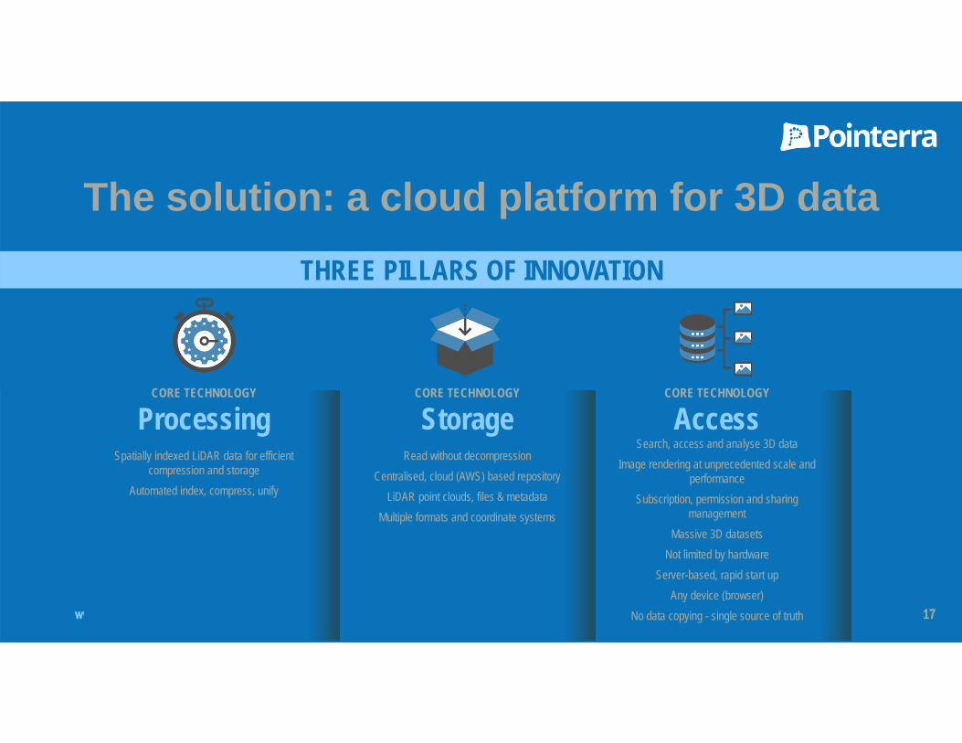
The solution: a cloud platform for 3D dataTHREE PILLARS OF INNOVATION
CORE TECHNOLOGY
ProcessingSpatially indexed LiDAR data for efficient
compression and storageAutomated index, compress, unify
CORE TECHNOLOGY
StorageRead without decompression
Centralised, cloud (AWS) based repositoryLiDAR point clouds, files & metadata
Multiple formats and coordinate systems
CORE TECHNOLOGY
AccessSearch, access and analyse 3D data
Image rendering at unprecedented scale and performance
Subscription, permission and sharing management
Massive 3D datasetsNot limited by hardware
Server-based, rapid start upAny device (browser)
No data copying - single source of truth

www.pointerra.com 18
Big Value Platform for Utilities
EN – Vegetation, Analytics, Maintenance & Assets Common Data Repository Catalog, manage and share all your 3D data at unlimited scale Viewable and actionable information
PDD – Spatial & Design Improved workflow from capture to design Security and data integrity for all your 3D/2D data
IT – Data Management CDE – Common Data Environment. One central, single source of truth and one set of data for all to access No implementation challenges – web based platform
Other Business Units – HSE, Regional Planning, Contractors Access and use of actionable information for safety, planning and external contractors
Customers Report Proven 10X+ ROI at Enterprise Level
www.pointerra.com 19
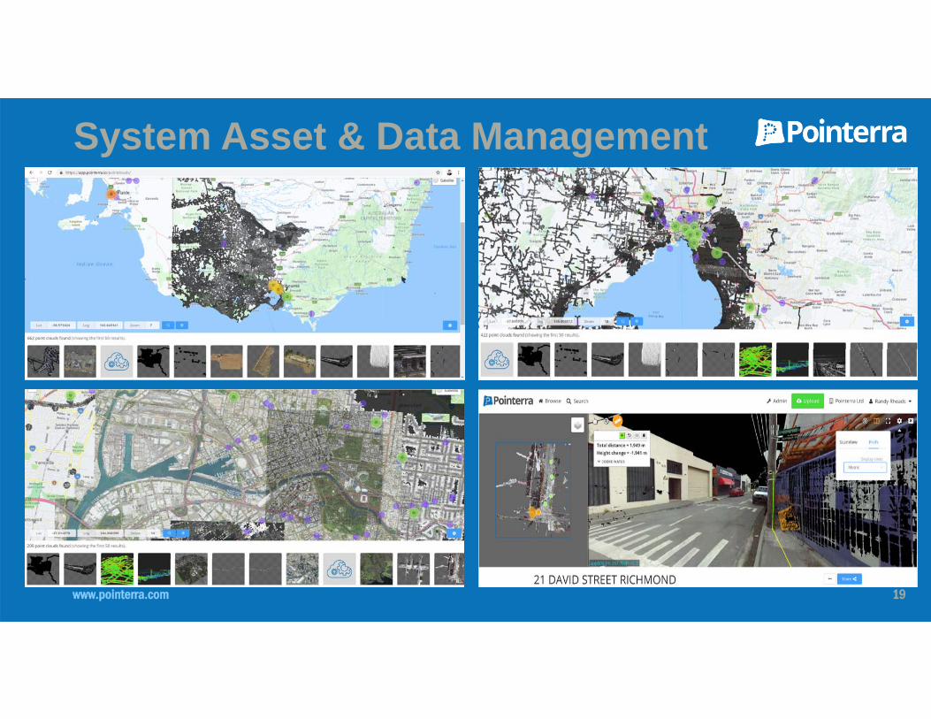
System Asset & Data Management

www.pointerra.com 20
Vegetation Analytics

www.pointerra.com 21
Additional Analytics

www.pointerra.com 22
ESRI Integration/Update

www.pointerra.com 23
Photogrammetry/Inspection Mode

www.pointerra.com 24
Additional Datasets Incorporated
www.pointerra.com 25
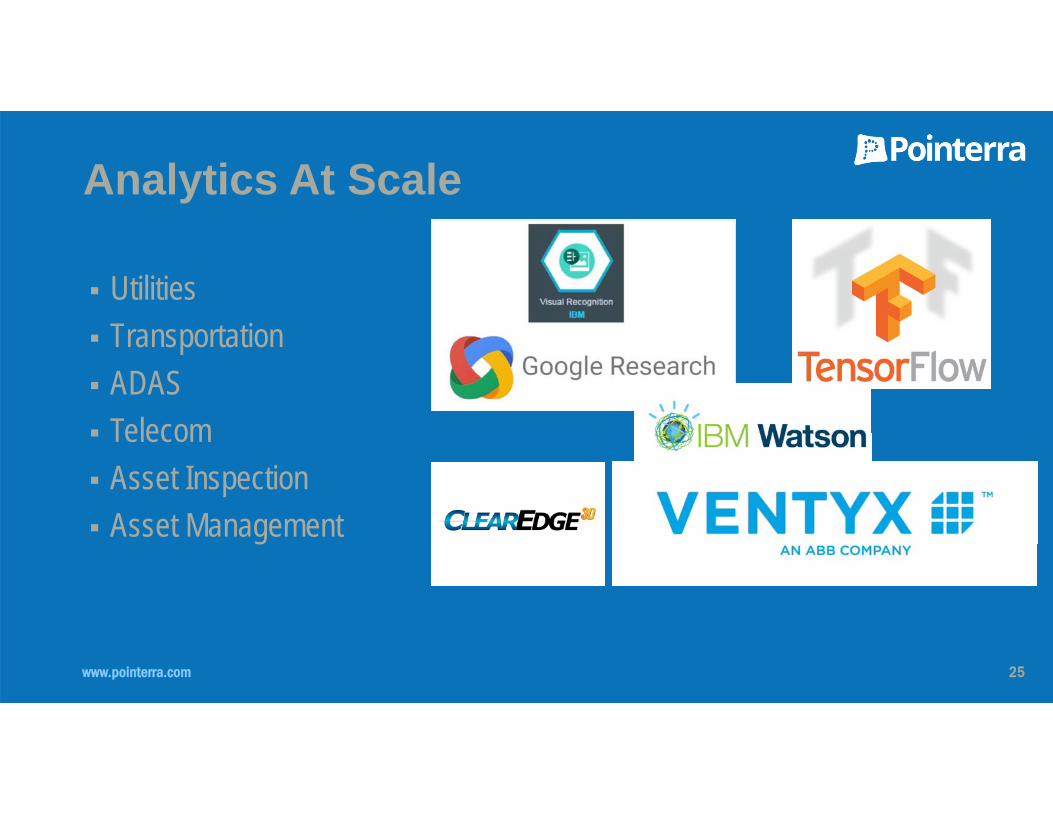
Analytics At Scale
Utilities Transportation ADAS Telecom Asset Inspection Asset Management

www.pointerra.com 26
www.pointerra.com 27
Recent Platform Solution Enhancements
Further integration into Autodesk and Bentley desktop applications – the ability to view and extract Pointerra hosted datasets from inside thesedesktop CAD packages
Photogrammetry processing and storing of 3D textured mesh and point cloud on Pointerra’s platform – using Bentley’s Context Capture realitymodelling solution (Others coming online soon)
New data layer types – 360 images, CAD models, Vectors, Geo Images, and externally hosted (WMS/WMTS) data layers (e.g. Nearmap) Geo search by coordinates and street addresses Long-term archiving service – low cost but readily accessible storage for older datasets Analytics in the cloud – change detection, machine learning, LiDAR classification
Pointerra has developed and deployed a number of initiatives in the last year to further streamline workflows and allow customers to run analytics against their data in the cloud

www.pointerra.com 28
Pointerra is a globally disruptive and world-first cloud technology that transforms the access
and usage of massive 3D datasets.
Pointerra’s cloud platform for 3D data enables actionable digital asset management
information to be used to manage physical assets from any device, anywhere, anytime.

www.pointerra.com3D Data Solved


