Advances and limitations in the use of satellite imagery for deforestation and forest degradation monitoring and reduction in tropical forests Janina Grabs, Federico Cammelli, Sam Levy, Leonie Hodel, Owen Cortner, Radost Stanimirova, Rachael Garrett Environmental Policy Lab, ETH Zurich https://epl.ethz.ch/ [email protected]; Twitter: @JaninaGrabs; @EPL_at_ETH
Transcript
Advances and limitations in the use of satellite imagery for deforestation and forest degradation monitoring and reduction in
3) Other public monitoring tools2) Other private monitoring tools
DETER, SAD: Modis (1-2 days, 250m); PRODES: Landsat (16 day, 30m)Starling: Uses Airbus’ SPOT satellites and Sentinel 1 for
1.5m resolution; used by Nestle for ZDC
… that promises to be a game changer for monitoring global deforestation
But: Continued gaps between what remote sensing can tell us and what we actually want to know:
Ideal-case:
Detection
Attribution
Policy response
Reduced deforestation
1) What happened?• Different definitions of ‘forest’ and acceptable/inacceptable deforestation• Many current tools rely on ‘tree cover loss’
• Tree cover loss only proxy – no good handle on biodiversity (esp. fauna –issue of ‘empty forests’)
• Complex on-the-ground reality of permitted vs. non-permitted clearing• But forest disturbance and degradation due to fires, selective logging,
etc. is almost as bad, and still underexplored
2) Who did it? • For policy response, need for correct attribution• Difficult to assess spatially since actors move; formal property boundaries
may not represent realities of control; boundaries may be wrong• Incorrect attribution holds legal, social and political risks
3) Why did they do it?• Important for legal responsibility (e.g. accident vs. malicious intent)• Need to understand drivers of behavior for correct intervention
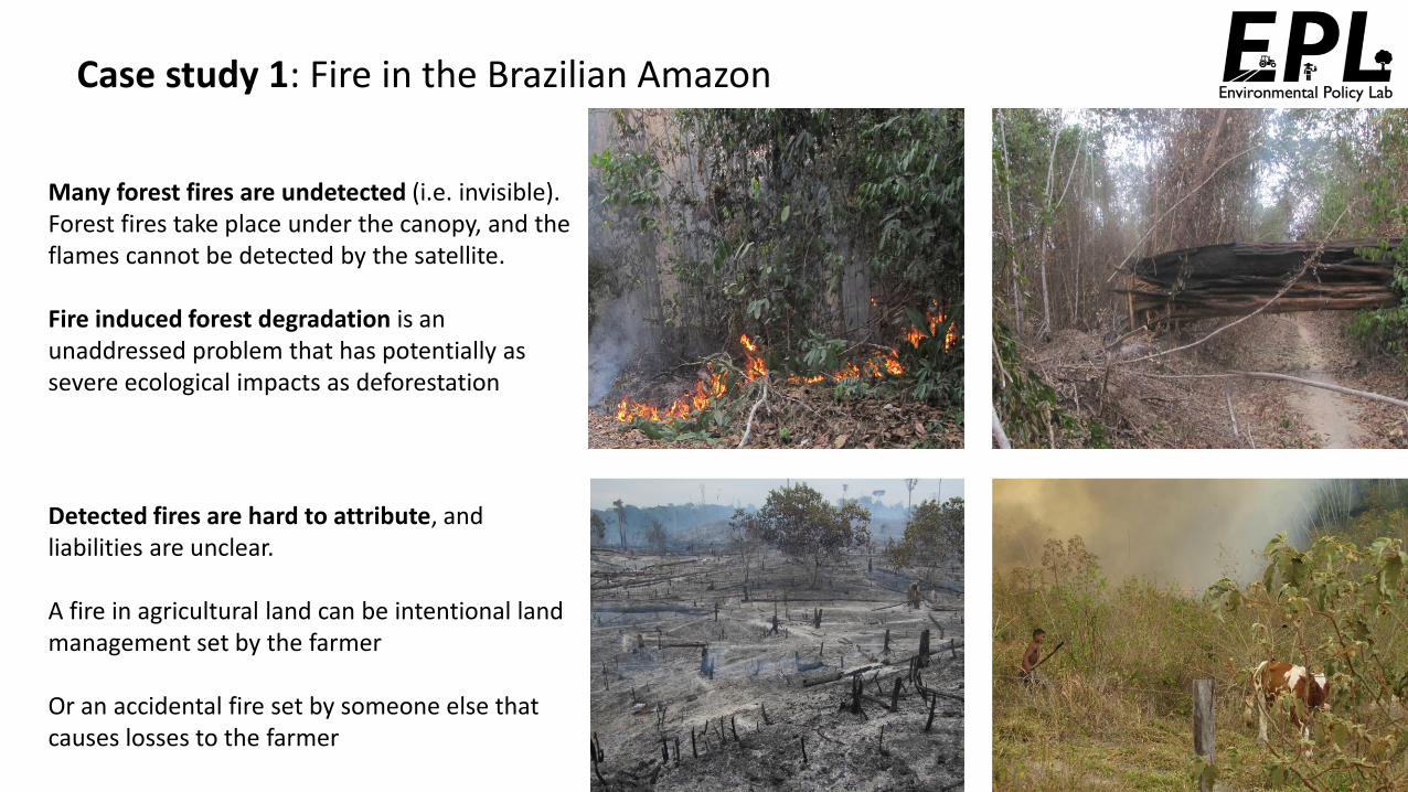
Case study 1: Fire in the Brazilian Amazon
Many forest fires are undetected (i.e. invisible). Forest fires take place under the canopy, and the flames cannot be detected by the satellite.
Fire induced forest degradation is an unaddressed problem that has potentially as severe ecological impacts as deforestation
Detected fires are hard to attribute, and liabilities are unclear.
A fire in agricultural land can be intentional land management set by the farmer
Or an accidental fire set by someone else that causes losses to the farmer
Case study 1: Fire in the Brazilian Amazon
Fires in the Amazon are set by different people for different reasons
Intentional, largely operated by illegal networks
Legal upon authorization, by farmers
Accidental, escaped from agricultural and deforestation areas
POLICYRESPONSE
Coercive action
Support to farmers
Alencar et al. 2020
1 Deforestation fires
2 Agricultural management fires
3 Forest fires
Forest is cleared Burning of dry biomass
Land used for pasture/agriculture
Burning of pastureOld pasture
Deforestation fires
Agricultural management
fires
Land used for pasture/agriculture
Case study 1: Fire in the Brazilian Amazon
Appropriate policy response requires knowledge of what burns and who lit the fires, In 2019 lack of reliable information sources led to widespread misdirection and polarization
Fires always happened as part of the Amazonian’s culture
Fires are a sign of increased deforestation by farmers and loggers
The Amazon cannot burn, it is a moist rainforest
Forest fires are set by NGOsreceiving foreign donor’s money
1 year later, a study published a few days ago shows…
However, interpreting these data is not easy…
Alencar et al. 2020Deforestation fires
Forest fires
Agricultural management
fires
No
. of
ho
tsp
ots
Case study 2: No Deforestation policy implementation in the palm oil sector
In the best cases, use of very high resolution satellite imagery allows for near-real time monitoring of clearing and plantation activity in known concessions (yellow)
Gaveau et al. (2017)
Case study 2: No Deforestation policy implementation in the palm oil sector
Yet, often land control (e.g. concession) and occupancy do not coincide, making attribution difficult
Out of 544 filed cases… Response31%No purchase28%Disputed26%Underway11%Moratorium
4%NDPE Policy1%Closed with resolution
“It’s not deforestation, it’s independent fires
due to dry climate”
“It’s not deforestation, it’s
replanting of existing oil palm”
“It’s deforestation, but not on the
concession”
“It’s deforestation on the concession, but not by the
company”
Case study 2: No Deforestation policy implementation in the palm oil sector
Illustration: Mighty Earth Rapid Response database (2017-2019; 108 cases in Malaysia and Indonesia; response from 20 traders)
This leads to high share of disputed cases and lower-than-expected follow-through on cases of alleged deforestation
Political risk further undermines deforestation reduction efforts
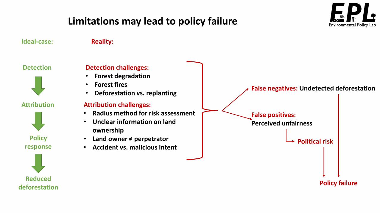
Limitations may lead to policy failure
Ideal-case: Reality:
Detection
Attribution
Policy response
Reduced deforestation
Detection challenges:• Forest degradation• Forest fires• Deforestation vs. replanting
Attribution challenges:• Radius method for risk assessment• Unclear information on land
ownership• Land owner ≠ perpetrator• Accident vs. malicious intent
Political risk
Policy failure
False negatives: Undetected deforestation
False positives: Perceived unfairness
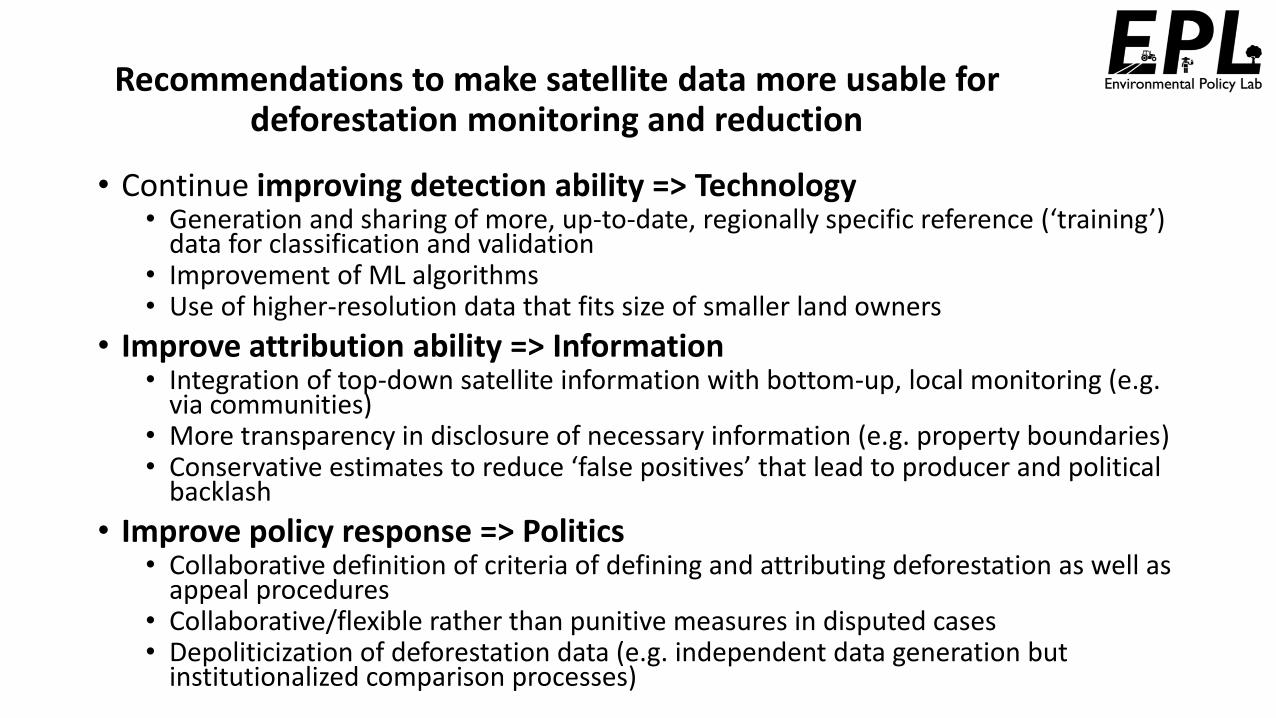
Recommendations to make satellite data more usable for deforestation monitoring and reduction
• Continue improving detection ability => Technology• Generation and sharing of more, up-to-date, regionally specific reference (‘training’)
data for classification and validation• Improvement of ML algorithms• Use of higher-resolution data that fits size of smaller land owners
• Improve attribution ability => Information• Integration of top-down satellite information with bottom-up, local monitoring (e.g.
via communities)• More transparency in disclosure of necessary information (e.g. property boundaries)• Conservative estimates to reduce ‘false positives’ that lead to producer and political
backlash
• Improve policy response => Politics• Collaborative definition of criteria of defining and attributing deforestation as well as
appeal procedures• Collaborative/flexible rather than punitive measures in disputed cases• Depoliticization of deforestation data (e.g. independent data generation but
• Alencar, A., Rodrigues, L., e Castro, I. Amazônia em Chamas - o que queima, e onde: nota técnica nº 5. Brasília: Instituto de Pesquisa Ambiental da Amazônia, 2020. https://ipam.org.br/bibliotecas/amazonia-em-chamas-5-o-que-queima-e-onde/
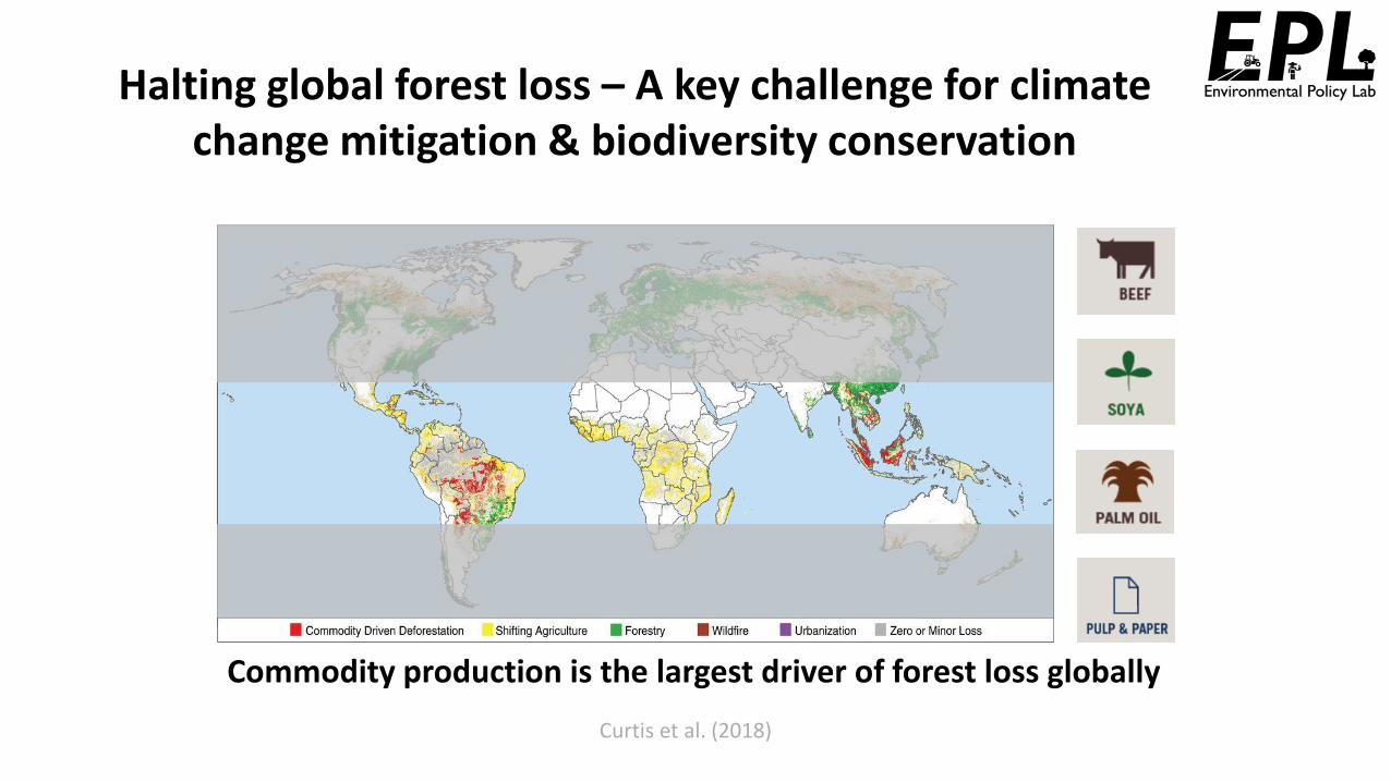
• Curtis, P. G., Slay, C. M., Harris, N. L., Tyukavina, A., & Hansen, M. C. (2018). Classifying drivers of global forest loss. Science, 361(6407), 1108–1111. https://doi.org/10.1126/science.aau3445
• Finer, M., Novoa, S., Weisse, M. J., Petersen, R., Mascaro, J., Souto, T., et al. (2018). Combating deforestation: From satellite to intervention. Science, 360(6395), 1303–1305. https://doi.org/10.1126/science.aat1203
• Gaveau, D. L. A., Pirard, R., Salim, M. A., Tonoto, P., Yaen, H., Parks, S. A., & Carmenta, R. (2017). Overlapping land claims limit the use of satellites to monitor no-deforestation commitments and no-burning compliance. Conservation Letters, 10(2), 257–264. https://doi.org/10.1111/conl.12256