Advances tn understanding the post-Caledonian structural evolution of the Bergen area, West Norway HAAKON FOSSEN Fossen, H.: Advances in understanding the post-Caledonian structural evolution of the Bergen area, West Norway. Norsk Geologisk Tidsskrt, Vol. 78, pp. 33-46. Oslo 1998. ISSN 0029-196X. The post-Caledonian development in the weste Bergen Are System and the nearby offshore area is characterized by a gradual transition from ductile through semi-ductile to brittle deformation. Interpretation of offshore seismic data shows a dominance of pre-late Jurassic faulting, with relatively minor late or post-Jurassic reactivation. This history is also seen in the Bjorøy tunnel in the Hjelteord fault zone, where most, but not all of the (semi)brittle faulting history is pre-Oxfordian (pre-late Jurassic). Pre-Oxfordian faults are typically cohesive fault rocks with striations on slip surfaces, whereas post-Oxfordian faults are identified as non-cohesive gouge zones without clear kinematic indicators. Slip analysis of the fault population with cohesive fault rocks in the Øygarden, Sotra, Løvstakken and Hjelteord area gives a relatively consistent NW -SE extension direction. Detailed investigation of Permian dikes in weste Sotra and Permo-Jurassic dikes in Sunnhordland indicate a very precise E- W extension direction at about 260 Ma. These dikes intruded along pre-existing faults and fractures, and are mostly undeformed or weakly jointed. Much of the brittle or semi-brittle deformation in the region is therefore thout to be older than the Permian dikes. This suggests that a change in the orientation of the minimum principal stress axis happened at some time between the formation of the fault systems and intrusion of the Permian dikes. Since the NW extension direction is similar to the early to mid-Devonian stretching direction detected in the Caledonian nappe region, it is suggested that the main population of faults with well-developed slip indicators west of Bergen reflects the (late) Devonian stress field. Haakon Fossen, Geologisk institutt, Universitetet i Bergen, A/gt. 41, N-5007 Bergen, Norway [email protected].no) Whereas the Precambrian and Caledonian development in the Bergen Are region has been the subject of detailed studies for about one century (Reusch & Kolderup 1902; Kolderup & Kolderup 1940; Weiss 1977; Sturt & Thon 1978), the post-Caledonian evolution has been afforded almost no attention in the published literature. Excep- tions are studies of ductile extensional tectonics of Devo- nian age (Rykkelid & Fossen 1992; Fossen 1993a; Wenn- berg & Milnes 1994) and paleomagnetic studies of Per- mian dikes in the western part of the area (Løvlie & Mitchell 1982) (see also Gabrielsen & Ramberg 1979). The recent discovery of the Jurassic Bjorøy Formation in a subsea tunnel through a fault zone near Bergen has provided invaluable information about the age of the brittle deformation of the area and about its burial depth in Mesozoic and Cenozoic times (Fossen et al. 1995 and 1997). The finding has also generated renewed attention to the brittle deformation structures in the Bergen Arcs. Together with the proximity of the western Bergen area to the well-known North Sea rift system and the recent advances in understanding stress, faults and joints, a more systematic analysis of brittle structures in the area seems appropriate. This article summarizes post-Caledo- nian structural data collected during the past decade from the western part of the Bergen Are System, and discusses their meaning in light of the new data from the Bjorøy tunnel and data that have been collected from seismic surveys immediately west of Sotra and Øygarden. It represents a synthesis of the available data, and forms a basis for continued work on the post-Caledonian devel- opment of the area. Regional setting The Bergen Are System (Kolderup & Kolderup 1940) (Fig. l) is composed of several arcuate tectonic units, named the Major and Minor Bergen Arcs (Færseth et al. 1977; Fossen 1989), the Lindås nappe (Bryhni & Sturt 1985) and the Ulriken Gneiss Complex/Rundemanen Formation (Fossen 1988), together with a western base- ment region called the Øygarden (gneiss) Complex. The Øygarden Complex is thought to represent parautoch- thonous basement (Sturt & Thon 1978) similar to the western part of the Western Gneiss Region to the north- east, and hence occupies the lowest tectonostratigraphic position in the region. With the exception of the Rundemanen Formation and the Lower Paleozoic rocks in the Minor and Major Bergen Arcs, the rocks contain igneous and/or deforma- tion structures of Precambrian age which are overprinted by Caledonian ductile deformation. The Caledonian foli- ation is mylonitic, and can generally be traced across lithologica1 boundaries. In this sense, the Caledonian deformation caused a penetrative linear and planar fab- ric that formed prior to and during the juxtaposition of the different tectonic units (Fossen 1986). The Caledonian deformation resulted in alternating domains of predominantly symmetric (coaxial deforma- tion) and asymmetric structures (non-coaxial deforma- tion), where the latter include S-C fabrics, asymmetric boudins, etc., that formed during thrusting. Subsequent reworking of these fabrics by ductile Devonian top-to-
Transcript
Advances tn understanding the post-Caledonian structural evolution of the Bergen area, West Norway
HAAKON FOSSEN
Fossen, H.: Advances in understanding the post-Caledonian structural evolution of the Bergen area, West Norway. Norsk
Geologisk Tidsskrift, Vol. 78, pp. 33-46. Oslo 1998. ISSN 0029-196X.
The post-Caledonian development in the western Bergen Are System and the nearby offshore area is characterized by a gradual
transition from ductile through semi-ductile to brittle deformation. Interpretation of offshore seismic data shows a dominance of
pre-late Jurassic faulting, with relatively minor late or post-Jurassic reactivation. This history is also seen in the Bjorøy tunnel in
the Hjeltefjord fault zone, where most, but not all of the (semi)brittle faulting history is pre-Oxfordian (pre-late Jurassic).
Pre-Oxfordian faults are typically cohesive fault rocks with striations on slip surfaces, whereas post-Oxfordian faults are identified
as non-cohesive gouge zones without clear kinematic indicators. Slip analysis of the fault population with cohesive fault rocks in the Øygarden, Sotra, Løvstakken and Hjeltefjord area gives a relatively consistent NW -SE extension direction. Detailed
investigation of Permian dikes in western Sotra and Permo-Jurassic dikes in Sunnhordland indicate a very precise E- W extension direction at about 260 Ma. These dikes intruded along pre-existing faults and fractures, and are mostly undeformed or weakly jointed. M uch of the brittle or semi-brittle deformation in the region is therefore thought to be older than the Permian dikes. This suggests that a change in the orientation of the minimum principal stress axis happened at some time between the formation of the
fault systems and intrusion of the Permian dikes. Since the NW extension direction is similar to the early to mid-Devonian stretching direction detected in the Caledonian nappe region, it is suggested that the main population of faults with well-developed slip indicators west of Bergen reflects the (late) Devonian stress field.
Haakon Fossen, Geologisk institutt, Universitetet i Bergen, A/legt. 41, N-5007 Bergen, Norway ([email protected])
Whereas the Precambrian and Caledonian development in the Bergen Are region has been the subject of detailed studies for about one century (Reusch & Kolderup 1902; Kolderup & Kolderup 1940; Weiss 1977; Sturt & Thon 1978), the post-Caledonian evolution has been afforded almost no attention in the published literature. Exceptions are studies of ductile extensional tectonics of Devonian age (Rykkelid & Fossen 1992; Fossen 1993a; Wennberg & Milnes 1994) and paleomagnetic studies of Permian dikes in the western part of the area (Løvlie & Mitchell 1982) (see also Gabrielsen & Ramberg 1979).
The recent discovery of the Jurassic Bjorøy Formation in a subsea tunnel through a fault zone near Bergen has provided invaluable information about the age of the brittle deformation of the area and about its burial depth in Mesozoic and Cenozoic times (Fossen et al. 1995 and 1997). The finding has also generated renewed attention to the brittle deformation structures in the Bergen Arcs. Together with the proximity of the western Bergen area to the well-known North Sea rift system and the recent advances in understanding stress, faults and joints, a more systematic analysis of brittle structures in the area seems appropriate. This article summarizes post-Caledonian structural data collected during the past decade from the western part of the Bergen Are System, and discusses their meaning in light of the new data from the Bjorøy tunnel and data that have been collected from seismic surveys immediately west of Sotra and Øygarden. It represents a synthesis of the available data, and forms a basis for continued work on the post-Caledonian development of the area.
Regional setting
The Bergen Are System (Kolderup & Kolderup 1940) (Fig. l) is composed of several arcuate tectonic units, named the Major and Minor Bergen Arcs (Færseth et al. 1977; Fossen 1989), the Lindås nappe (Bryhni & Sturt 1985) and the Ulriken Gneiss Complex/Rundemanen Formation (Fossen 1988), together with a western basement region called the Øygarden (gneiss) Complex. The Øygarden Complex is thought to represent parautochthonous basement (Sturt & Thon 1978) similar to the western part of the Western Gneiss Region to the northeast, and hence occupies the lowest tectonostratigraphic position in the region.
With the exception of the Rundemanen Formation and the Lower Paleozoic rocks in the Minor and Major Bergen Arcs, the rocks contain igneous and/or deformation structures of Precambrian age which are overprinted by Caledonian ductile deformation. The Caledonian foliation is mylonitic, and can generally be traced across lithologica1 boundaries. In this sense, the Caledonian deformation caused a penetrative linear and planar fabric that formed prior to and during the juxtaposition of the different tectonic units (Fossen 1986).
The Caledonian deformation resulted in alternating domains of predominantly symmetric (coaxial deformation) and asymmetric structures (non-coaxial deformation), where the latter include S-C fabrics, asymmetric boudins, etc., that formed during thrusting. Subsequent reworking of these fabrics by ductile Devonian top-to-
34 H. Fossen
Fig. l. Geologic map of the Bergen Are System, including the pre-Quatemary geology to the west. GF = Grimevatn Fault, TF = Totland Fault.
the-(W)NW shear deformation is recognized in parts of the Major Bergen Are and particularly in the western part of the Øygarden Complex, although the age relations are less obvious in the latter case (Fossen & Rykkelid 1990; Fossen 1993a).
The penetrative, duetile fabric is cut by a number of cataclastic zones, breccia zones, faults and joints which occur throughout the are system (Figs. l, 2). These include two substantial ENE-WSW -tren ding eataclastic zones that transect the arcs (the Grimevatnet and Tot-
Fig. 2. Mylonitic fabrics in gneisses of the Øygarden Complex showing trains or
packages of asymmetric folds, small-scale thrusts and shear bands indicating
(semi-)ductile top-to-the-WNW shearing. These structures are related to post-col
lisional extensional tectonics in Lower Devonian time, and are cut by a normal
fault in the left-hand side of the photograph (black arrow). Looking NNE,
Toftøy.
NORSK GEOLOGISK TIDSSKRIFT 78 (1998)
land faults in Fig. 1), cataclastic zones in the Fana area of various orientations (Fossen & Ingdahl 1987), NESW-trending faults in the Øygarden area, and N(NW)S(SE)-trending fractures related to the Hjeltefjord fault zone, in addition to a number of smaller faults mapped in various parts of the Bergen Are System (Færseth et al. 1977; Johns 198 1; Austrheim 1978; Henriksen 1979; Bering 1984; Ingdahl 1985; Fossen 1986, 1989). In general, these structures have not been studied in great detail except for recent thesis work by students from the University of Bergen in parts of Øygarden. We here concentrate on the western part of the Bergen Are System, whieh is very well exposed and also situated close to the area eovered by North Sea commercial seismic data.
Ductile, post-Caledonian deformation in the Øygarden Complex
The strong top-to-the-(W)NW duetile to semi-ductile deformation in the western part of the Øygarden Complex described by Fossen & Rykkelid (1990) and Rykkelid & Fossen ( 1992) bears striking kinematic and geometric similarities with the D2 deformation (backmovement deformation) in the deeollement zone/Bergsdalen Nappes east of the Bergen Are System (Fossen 1993a). Characteristic structures include asymmetric boudins, S-C structures, development of asymmetric porphyroclasts, and formation of NW-verging folds with SE-dipping axial surfaces (Fig. 2). It is also very similar to the W(NW)-verging structures in the Western Gneiss Complex east of the Devonian Solund basin to the north (Milnes et al. 1988; Chauvet 1989; Chauvet & Seranne 1989). The top-to-the-(W)NW shearing is therefore ascribed to the Devonian extensional deformation that rapidly followed the well-known Caledonian eontraetional deformation in southern Norway (Fossen 1992, 1993a). Since this deformation has been deseribed in detail before, we here foeus on the subsequent, more brittle deformation of the western Bergen Are System.
Onshore fault patterns
Information about the fracture patterns in the BergenSotra area has been gained by interpretation of aerial photographs, general geologie mapping and field studies of fractures. The most pronouneed fracture systems ex-. hi bit NNW-NE tren ds. Of partieular interest in this context is the Hjeltefjord fault zone separating the SotraØygarden area from the Askøy-Bergen area (Fig. 1).
The Hjeltefjord fault zone
Geologic mapping of the area, particularly in the Flesland-Sotra area, shows that anorthositic and man-
NORSK GEOLOGISK TIDSSKR!Ff 78 (1998)
km
Post-Caledonian evolution, West Norway 35
SOTRA
Rustefj. Fault
Hjetteljord Fautt Zone
BERGE� -
-4 km
Fig. 3. Protile across the Hjeltefjord fault zone, using information from the Bjorøy tunnel (Fossen et al. 1 997) and seismic line ST8 125-250 (offshore). Extension of the Upper Jurassic strata over Sotra indicates a significant down-to-the-E throw of the Hjeltefjord fault zone. Vertical exaggeration = 4x. For location, see Fig. l .
geritic lithologies of the Bergen Are System occur on the eastern (Flesland) side of the fault zone, striking due east-west with a southerly dip of about 45° (Fig. 2 in Fossen et al. 1997). None of these characteristic lithologies occur on the western side of the fjord (Sotra), and a significant displacement must therefore be associated with the Hjeltefjord fault zone. Similarly, metagabbros, greenschists and mica schists of the Minor Bergen Are do not appear on the western side of the Hjeltefjord fault zone. Considering the common interpretation that the allochthonous mangeriticfanorthositic rocks and the rocks of the Minor Bergen Are occupy a tectonostratigraphically higher position than the Øygarden Complex, the Hjeltefjord fault zone appears to have a down-to-theeast component of displacement. This is also indicated by comparing the level of the westerly dipping Late Jurassic layers mapped on the seismic lines west of Sotra and Øygarden with the occurrence of chronologically equal sediments in the Bjorøy tunnel, where a post mid-Jurassic down-to-the-east displacement of several hundreds of meters is indicated (Fig. 3). However, striations on approximately N -S-oriented fault surfaces along the Hjeltefjord fault zone indicate dextral strikeslip or oblique slip movements. As argued below, these kinematic indicators are thought to be pre-late Jurassic, whereas the late or post-Jurassic faults or slip surfaces did not develop readily identifiable striations.
Although much of the Hjeltefjord fault zone is below sea leve!, breccias and microfaulted rocks are exposed on several of the islands in the Korsfjord-Hjeltefjord area. The !argest of these islands (Lille Sotra) is more affected by faulting than rocks away from the Hjeltefjord area. The high frequency of brittle deformation structures in Lille Sotra reveals that the Hjeltefjord fault zone is a wide and significant fracture zone.
Many of the faults and fractures along the Hjeltefjord fault zone are filled with quartz, calcite, fluorite, epidote and sulphides, some of which exhibit ideomorphic crys-
tals grown in open voids. Such mineral growth is typical for the near vicinity of the Hjeltefjord fault zone, and rapidly disappears or decreases in frequency to the east and west of this zone. One exception to this general observation is epidote-group minerals, which occur along many NE-trending faults outside of the Hjeltefjord fault zone.
Several episodes of movement along the Hjeltefjord fault zone have been demonstrated from the Bjorøy tunnel (Fossen et al. 1 997). Here, a NNW-SSE-striking fault belonging to the Hjeltefjord fault zone contains old fault rocks formed at deeper depths (semi-brittle) which are overprinted by more brittle and partly open fractures both before and after deposition of the late Jurassic Bjorøy Formation. .
The latest faults along the Hjeltefjord fault zone are identified as gouge zones with none-cohesive fault rocks that typically contain abundant clay minerals. These fault rocks thus appear to have formed at very shallow crustal levels. Such zones are easily eroded and therefore not well exposed. However, they are found in the Bjorøy tunnel, where they appear to be associated with deformation of the Late Jurassic (Oxfordian) sediments. A latest Jurassic or younger age is therefore assigned to these faults, which generally are reactivated structures. No distinct slip planes with associated slip indicators have been found in these faults with non-cohesive fault rock. They are therefore not included in the kinematic analysis presented below.
A large number of conspicuous and morphologically significant subplanar fractures occur along and in zones subparallel to the Hjeltefjord fault zone. Little or no slip is associated with the fractures, and they therefore classify as joints. These joints cross-cut man y faults with striated slip surfaces, but are themselves never found to be affected by the faults. The joints therefore appear to be a relatively late development - at !east later than the main faulting with associated cohesive fault rock formation.
36 H. Fossen
Figure 4 shows that many of the joints in the study area are approximately N-S to NNW-SSE oriented, and the common NE-SW fault orientation is hardly reflected at all among the observed joint population. This may indicate that the joints formed as tension fractures by later reactivation of the Hjeltefjord fault zone. If this interpretation is correct, the jointing occurred as the minimum stress axis (a 3) was oriented E-W to ENE-WSW. The age of this deformation is not clear, although it may well be contemporaneous with the down-faulting of the Jurassic Bjorøy Formation, i.e. latest or post-Jurassic in age.
Rustejjord fault
Another NNW-striking lineament (Rustefjord fault in Fig. 5) is found in southern Sotra. This apparently very steep structure appears as a significant lineament on satellite and aerial photographs, and possibly crosscuts a set of NE-striking fracture zones in the area. Geologic mapping around the fault (Bering 1984) indicates that litho1ogies cannot be correlated across the structure (Fig. 6), and the lineament thus appears to be a fault (Rustefjord fault). The local geomorphology indicates that the Rustefjord fault downthrows to the west, although no conclusive evidence has yet been found for this interpretation. There are indications that this fault was reactivated several times. First, several post-Caledonian dikes of Permian age (see below) are associated with steep
Fig. 4. (a) Orientation of fractures with no visible shear displacement and (b)
faults with evidence of shear displacements in the Øygarden Complex west of
Bergen (right-hand rule). Whereas faults typically ex hi bit N-S to NE-SW orientations, most joints are N(NW)- S(SE) oriented with a NW -SE oriented
subpopulation.
NORSK GEOLOGISK TIDSSKRIFT 78 (1998)
fractures along the Rustefjord fault. Similar dikes have not been found elsewhere in the Øygarden Complex, but occur to the south (Færseth et al. 1976). The deep (mantle) source of similar Permo-Triassic dikes in the Sunnhordland area (the southernmost of the dikes marked on Fig. 5) (Færseth 1978) and their restricted occurrence in the study area along the Rustefjord fault indicate that this fault was a deep-rooted structure of significant importance in the Permian. Second, o ne of the Permian dikes shows sign of gentle brecciation where a fault parallels the dike margin. Finally, a completely non-cohesive fault rock (Fig. 7), which must have formed during faulting at very shallow crustal depths, has been observed along the same lineament. The alkaline dikes and their implications for the tectonic evolution of the area are discussed in more detail below.
Sotra -Øygarden area
NE-striking faults are widespread throughout the SotraØygarden area, and occur mostly as dip-slip normal faults with well-polished fault surfaces. Many of these faults are NW-dipping, but SE-dipping faults are also common, and they show a wide range in dip. Epidotegroup minerals accompany these fault zones, and the epidote infill is commonly deformed and locally shows polished and striated slip surfaces. In addition, a zone of alteration in the host rock is marked by anomalously reddish K-feldspar. Relative age relations indicate that these faults predate swarms of joints that are subparallel to the NNW-striking Hjeltefjord fault zone. This does not mean that the Hjeltefjord fault zone is entirely younger than the NE-striking faults, because the Hjeltefjord fault zone has a long history. Hence, the joints are interpreted to be the result of reactivation of the Hjeltefjord fault zone (see above).
Askøy-Bergen area
NNE-striking fracture zones in Askøy seem to correlate mineralogically and kinematically to the more NE-striking faults observed in the Sotra-Øygarden area (Figs. l , 5). The same is the case with NE trending faults in the southernmost Askøy (Askvik 197 1), whereas NE to ENE-striking faults in the central and southern part of Askøy, same of which have mappable offsets with normal components up to 50 m, are of unknown significance. Similar zones occur on the mainland to the south, and a significant fracture zone runs through the Løvstakken area in a SSW direction. Significant fracturing and fault rock development is seen along this zone.
East of Bergen the fracture frequency seems to decrease somewhat, except for two major ENE-WSW trending fault zones with mappable offsets and 100-mwide cataclastic zones associated with them (Grimevatnet and Totland faults, Fig. 1). The zones have dextral apparent offset in map view, and observed subhorizontal
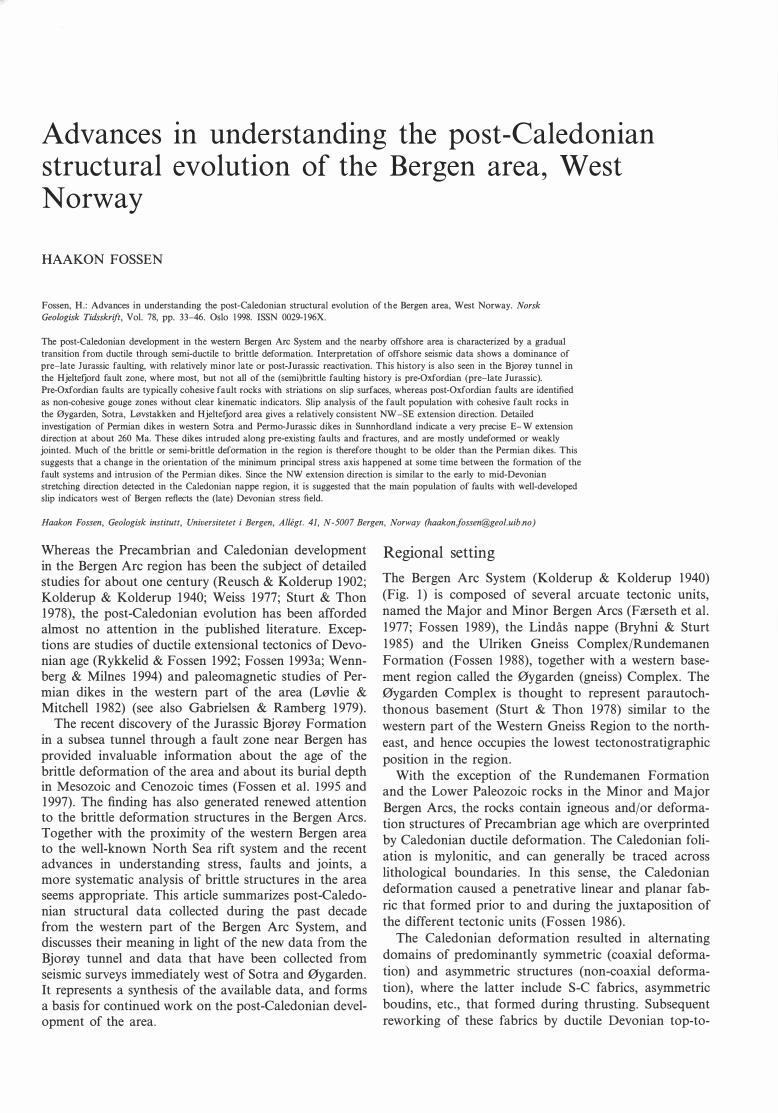
NORSK GEOLOGISK TIDSSKRIFT 78 (1998) Post-Caledonian evolution, West Norway 37
Fig. 5. Fault map of the area west of Bergen. Results of kinematic analysis of fault-slip data are shown as lower hemisphere stereoplots. Arrows indicate tension
directions, and shaded areas of stereoplots indicate area of tension at the time of faulting. B = Brandsholmane dike locality, Bj. = Bjorøy locality.
fault striations indicate that they may be true strike-slip faults. Similar zones of cataclastic rocks occur in the Lysefjord/Fana area (Fossen & lngdahl 1987), many of which are NE-SW trending. As in the Sotra-Øygarden
area, these zones are cut by younger NNW -SSE-trending fractures and minor faults. Again, it seems that NNW -SSE structures (Hjeltefjord fault zone) were active at a later stage than the NE-SW-trending faults.
38 H. Fossen
Microfabrics
lineation and follation
Microfabric studies of fault rocks in the Bergen area indicate that some deformation zones, particularly those with a NE-SW orientation, show a development from semi-ductile ultramylonitic fabrics via fractures with slightly recrystallized matrix or fracture fill to fractures with no sign of crystalloplastic deformation mechanisms (Fig. 8). The ultramylonitic fabrics occur in wide fault zones and exhibit a finer grain size than the those related to the Caledonian mylonitic deformation and the ductile, Devonian top-to-the-NW movement. It thus appears that the ultramylonites formed near the brittle-ductile transition in the crust. The fractures with less or no related recrystallization cut the ultramylonitic foliation, and clearly formed at higher crustal levels.
In contrast, the NNW -SSE-trending fractures generally lack the fine-grained ultramylonite stage, but as demonstrated from the fault zone between Bjorøy and the mainland (Fossen et al. 1997), evidence of recrystallized quartz in quartz-filled fractures cut by later, brittle fractures without re1ated recrystallization is observed.
Offshore fault patterns Several commercia1 seismic lines have been shot close to the coast of Sotra, and contain valuab1e information
LINDÅS NAPPE w Mangeritic gneisses
ØYGARDEN COMPLEX
l•• l Gneiss (unseparated)
IYPJ'I1 Granitic gnelss - Amphiboltte, metagabbro
1ft:;;! Amphibolitic gneiss
G::J Agmatitic gneiss
NORSK GEOLOGISK TIDSSKRIFT 78 (1998)
Fig. 6. Mapping in the southem part of the
Øygarden Complex indicates the presence
of faults with significant offset, particularly
the Rustefjord fault. Modified from Bering
et al. (1988).
about the fault population of the area. The seismic data that have been applied in this study are the eastern parts of the regional surveys ST84201, ST8301, ST820 1, ST8125, NNST84-03, TLGS-78, GSB-85, NE, NVGT-88, 805, NSDP84, and SG8403, and the locations of the seismic lines are indicated in Fig. 5.
The Øygarden Fau/t Complex
The dominating structure in the off-shore area is the Øygarden Fault Complex, which separates kilometerthick sequences of Jurassic, Triassic and possibly older sediments in the hanging wall from basement and onlapping Jurassic sediments in the footwall (Horda Flatform). The geometry of the Øygarden Fault Complex is that of a large-scale segmented fault system where each of the segments are linked with complex relay or accommodation zones.
A major segment of the Øygarden Fault Complex (here termed the Sotra fault) is situated about 30 km west of Sotra and Øygarden. The central portion of this fault has a N-S trend, but bends to the west toward its northern tip, where it enters an accommodation zone (Scott & Rosendahl 1 989). North of this accommodation zone the Perm o-Triassic fault polarity is reversed from W -dipping to E-dipping (Gabrielsen et al. 1990; Færseth et al. 1995). To the south, the Sotra fault shows a rapid decrease in
NORSK GEOLOGISK TIDSSKRIFT 78 (1998)
Fig. 7. Subvertical fault in granitic gneiss, Sotra. The completely non-cohesive
fault rock consists of rounded fragments in a sand y matrix of similar composition
as the side rock, indicating that the fault rock forrned by grinding at a shallow
crustal leve!. See Fig. 5 for location. UTM 808904.
displacement at the latitude of southern Sotra, typical for regions of linked fault segments (e.g. Childs et al. 1995). In this area, the Sotra fault segment is linked to the marginal fault of the Stord Basin through another accommodation zone. Onlapping Jurassic strata indicate
Fig. 8. Microphotograph of ultramylonite from a fault zone on Lokøy, W of
Sotra, cut by more brittle microfaults. The fabrics seen in this photograph are cut
by a Permian dike (not shown), and are therefore pre-Permian in age. This sort
of textural relationship is common in the Bergen Are System. UTM 778949.
Post-Caledonian evolution, West Norway 39
that this structure was established prior to the main
late-Jurassic rifting event in the North Sea.
The area immediately west of Sotra
The footwall of the Sotra fault is internally faulted (Fig. 1), although to a lesser extent than the area to the west. Figure 5 displays an interpretation of the fault pattern of the area east of the Sotra fault, as well as the position of the available seismic lines. These faults are well defined on the seismic sections where Jurassic sediments are present, but near land, where the Mesozoic sediments are removed by erosion, only basement (sea bottom) scarps indicate possible fault locations. The possibility and reliability of fault correlation depend mainly on the local distribution of seismic data (shown in Fig. 5), and the geometric characteristics or seismic expression of the faults on each seismic line.
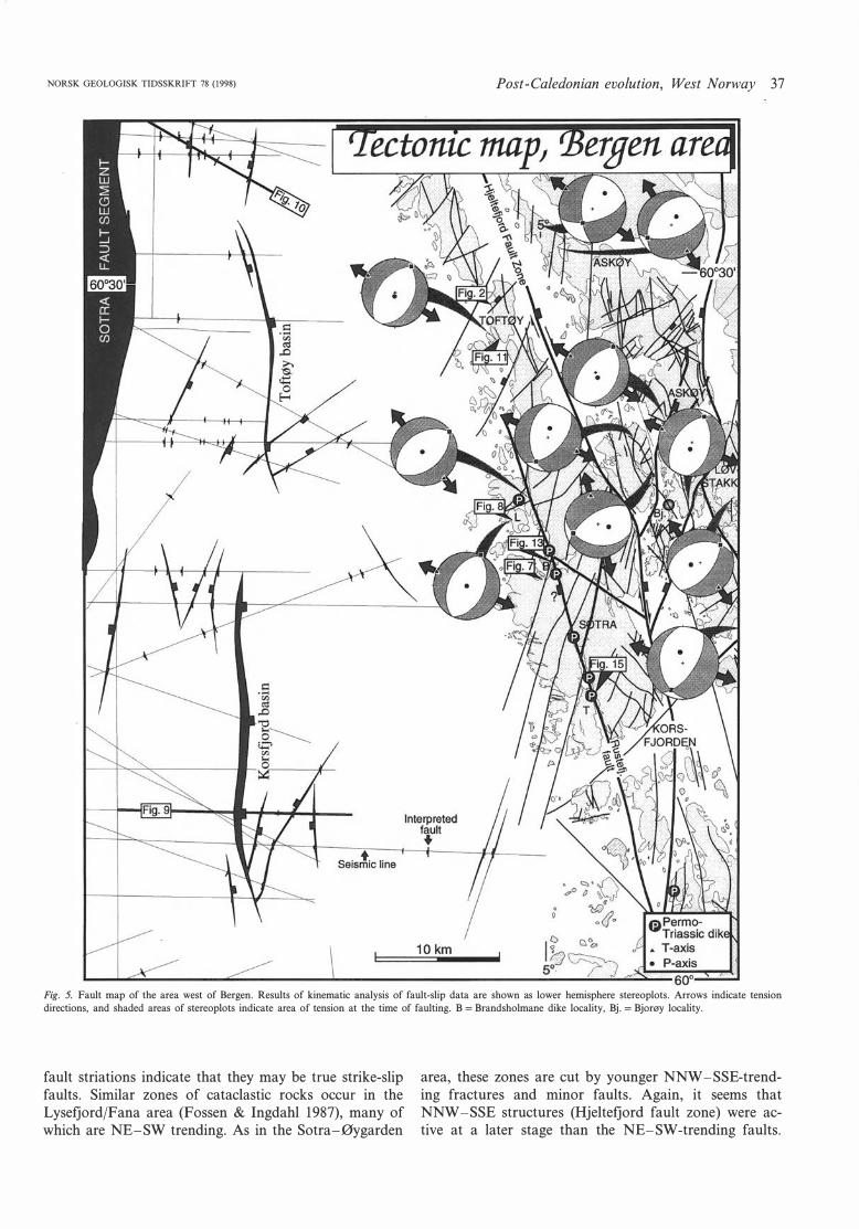
A characteristic feature of the area between Sotra and the Sotra fault is several N-S trending half-grabens bound by east-dipping normal faults. The two most pronounced half-grabens form basins filled with midJurassic sediments, and are informally named the Korsfjord and the Toftøy basins, respectively (Fig. 5). The fault planes dip about 65° to the east, and the maximum displacement of the top basement surface along these east-dipping faults is almost l km. Smaller faults are predominantly N-S to NE-SW striking, although correlation between the scattered lines may be difficult or impossible in some areas. /
The fault displacement of the top basement surface is everywhere considerably 1arger than of the late Jurassic strata (Fig. 9). This indicates that most of the fault movement took place in pre-late Jurassic (pre-Brent Fm.) time, i. e. prior to deposition of the Bjorøy Formation. This is more clearly seen further west, for example along the Sotra fault, where the pre-late Jurassicjpostlower Devonian fault displacement is one to two orders of magnitude larger than the displacement of the late Jurassic strata (Fig. 10). Some of this faulting is clearly Permo-Triassic (Badley et al. 1984; Gabrielsen et aL 1990; Steel & Ryseth 1990; Færseth et al. 1995), although the possibility that the fault may be older cannot be excluded. These observations show that the late or postJurassic fault activity is of re1ative1y minor importance and only represents a mild rejuvenation of a pre-existing fault array in the study area.
Slip directions and extension directions Linear structures are locally developed on mineralized fault surfaces, primarily as striations on mechanically polished surfaces in the microbreccias in the faults (Fig. 1 1). A number of fault planes with fault striae have been measured in the basement west of Bergen, and the method and program described by Marret & Allmendinger (1990) have been used to analyze the data.
40 H. Fossen
0.0
0.5
1.0
1.5
2.0
2.5
3.0
The application of stress inversion programs (e.g. Etchecopar et al. 1981; Angelier 1984) gives similar results to the kinematic approach applied in this article. The kinematic data exclude the latest faults of post-Middle Jurassic age with non-cohesive fault gouge, and thus represent pre-late Jurassic faulting events during which the extension direction remained more or less unchanged.
Analysis of the slip surfaces should be done with care, since we know that the faults were active at different depths and therefore at different times and possibly during shifting stress conditions. Nevertheless, if the slip data extracted from each locality are analyzed kinematically as a single data set, it is found that the vast majority of the data fit a simple deformation with vertical shortening and horizontal extension (Fig. 5). The exact extension direction is seen to vary somewhat from locality to locality, but the general trend is NW-SE. A compilation of data from all localities in the Øygarden Complex (Fig. 12) shows a single, well-defined extension
NORSK GEOLOGISK TIDSSKRIFT 78 (1998)
Fig. 9. Seismic profile across the
Korsfjord Basin showing pre-late
Jurassic faults with evidence of
some J urassic reactivation. TS =
top Sognefjord Formation, TB =
top Brent Formation. See Fig. 5
for location.
direction which is horizontal and trending Nl28E. Correspondingly, NE-SW trending faults are mostly dipslip, whereas N-S to NNW-SSE trending faults (e.g. the Hjeltefjord fault zone, Fig. l) show clear evidence of a dextral strike-slip component. This is the same stretching direction and deformation style as reported from the Devonian Solund basin (Seranne & Seguret 1987; Seranne et al. 1989), and preliminary data indicate a similar stretching direction for faults in the Sunnhordland area south of Bergen and in the Jotun Nappe to the east. Because the majority of the data are both internally and geographically consistent, the results indicate that most of the striated slip surfaces formed or were reactivated in a regional stress system that caused vertical shortening and NW -SE extension.
The kinematic approach applied here calculates the deformation that fits all the fault data as well as possible. Because the majority (but not all) of the fault slip data conform to the calculated deformation type, it is reason-
Fig. JO. Seismic profile across the
Sotra fault segment of the
Øygarden Fault Complex. The
pre-late Jurassic throw
component for this fault
is much larger !han the late or
post-Jurassic component. Note
that basement in the hauging wall
may or may not include Devonian
sediments. BQ =base Quaternary,
TS = top Sognefjord Formation,
TB = top Brent Formation. See
Fig. 5 for location.
NORSK GEOLOGISK TIDSSKRIFT 78 (1998)
Fig. 11. Photograph of (a) NW-dipping fault (about 5 m high clifl) and (b) striae
on the fault surface in gneisses of the Øygarden Complex at Balsneset, Toftøy
(UTM 766096).
able to conclude that this deformation is responsible for most of the faulting. The analysis does not indicate whether there were orre or several deformation episodes of similar character. Furthermore, it is very possible that the subset of the fault population that does not fit with the calculated deformation type formed under different stress conditions (i.e. at different times), and more detailed analyses are currently being carried out to investigate this issue.
Post-Caledonian evolution, West Norway 41
Fig. 12. (a) Kinematic data from all faults measured in the Øygarden Complex
west of Bergen. Great circles indicate fault planes and arrows indicate associated
slip directions. A variety of fault orientations and slip directions (dip-slip to
strike-slip) are recorded. (b) Extensional (shaded) and compressional fields as calculated from the kinematic field data. The contractional (P) and extensional
(T) axes for the data sel are indicated. The many filled circles and open squares
indicate orientations of calculated P-axes and T-axes, respectively. (c) The
contoured T-axes distribution shows a single, well-defined NW -SE-oriented
extension direction for the entire data sel.
Alkaline dikes and the Permo-Triassic stress field A number of unaltered and generally undeformed dikes occur along the Rustefjord fault (Fig. 5). The dikes are best exposed along the shore, where they normally occur with widths of less than 50 cm, although local widths of up to 4 m occur. The dikes are intruded along steep fracture systems, but the dikes themselves are generally undeformed or weakly jointed. They usually occur as
42 H. Fossen
parallel dike segments varying from some tens of centimeters up to some hundreds of meters in length. Their Jength is to some extent proportional to their thickness, i.e. thick dike segments tend to be longer than thin ones.
Individual segments may be linked by a bend in the dike orientation if the segments are dose enough, or may be indirectly linked by fractures running from one dike tip to the other (Fig. 1 3). In three dimensions the widely applied model that dikes (fractures) are continuous at depth and split into a series of fringes seems to fit these observations very well (e.g. Anderson 1 951 ) (Fig. 14). The same geometry is seen in man y of the approximately N-S-trending fracture systems in the Øygarden Comp1ex. It has been proposed that such dike geometries refiect a change in the orientation of the least principal stress toward the surface (Anderson 1 951 ; Delaney & Pollard 1981 ). Alternative ly, the en echelon patterns can form as a result of combined extension and shear along the dike (Delaney & Pollard 1 981 ). Field evidence suggests that the latter explanation can be ruled out. If the formation of dike-filled fractures is related to dike intrusion, this indicates near-surface conditions during intrusion. However, the en echelon fracture pattern may well have been formed long before dike intrusion, infiuenced by a shear component along the fractures.
(a)
o dike .. � <
f) :::=::;> /"""""
-�---/
e .-• �
o - ",.;;::-
NORSK GEOLOGISK TIDSSKRIFT 78 (1998)
Several of these dikes have been dated by the K-Ar method to ca. 260 Ma (Løvlie & Mitchell 1 982), and thus correspond to the older generation of dikes described from the Sunnhordland region (Færseth et al. 1 976). However, the southernmost dike shown in Fig. 5 was reported to yield a Triassic age by Færseth et al. (1976). Based on pa1eomagnetic considerations, Løvlie & Mitchell (1 982) suggested a minimtim temperature of the host rock during intrusion of ca. 1 50 oc, i.e. the dikes intruded at depths in excess of ca. 5 km. However, the amphibole and whole rock results of their K/Ar analyses are generally indistinguishable, suggesting that no significant reheating above about 150 °C has taken place since emplacement. Hence, the intrusion temperature in the host rock is not likely to have been in excess of 150 °C.
The fractures along which the Perm o-Triassic dikes occur show little evidence of vertical movements, and the dikes therefore seem to have been emplaced as the fractures acted in a tensile mode. Because most Perm o-Triassic dikes along the coast of western Norway have a N-S to NNW -SSE orientation, it has been assumed that the dikes intruded during approximately E-W extension (Færseth et al. 1 995). However, if the dikes intruded along pre-existing fracture zones, their orientation would be controlled not only by the existing stress field, but
. : .:·
:'
: �.: :'·
50 cm
10cm Fig. 13. (a) Map of a segmented dike system at Brandsholmane (W of Sotra) which
follows an en echelon fracture system. Individual dike segments are connected by bridge
systems as shown in (b ). See Fig. 5 for location.
NORSK GEOLOGISK TIDSSKRIFT 78 (1998)
Fig. 14. Three-dimensional interpretation of the fracture system mapped in Fig.
13.
also by the orientation of such fractures. Hence, a more rigorous analysis is required before making assumptions about the extension direction during intrusion.
Most of the dikes along the Rustefjord fault show irregular contacts with the country rock, and in many cases it is possible to identify points (in plan view) on each side of the dike that were in contact prior to dike intrusion. Such points may be corners where locally the dike has followed a fracture of a different orientation, or where gneissic layering or.quartz veins meet the dike wall at each side of the dike (Figs. 15 and 16). The straight line between two such points is the horizontal component of the local displacement vector related to the dike intrusion. For this method to be accurate, one must choose surfaces that contain or are dose to the extension vector. In the common case where the width of the dike is larger than the vertical displacement by an order of magnitude or more, horizontal outcrop surfaces are suitable.
The results of this method (Fig. 1 7) show that the extension associated with the Perm o-Triassic dike intrusions is almost due E-W. Preliminary analysis indicates similar extension directions for both Permian, Triassic and Jurassic dikes in the Stord-Tysnes area to the south. This extension direction is different from the one determined from the fault slip analyses (Figs. 5, 1 2), and if we make the assumption that the extension associated with dike intrusion is related to the concurrent regional stress field, it thus appears that dike intrusion occurred not only at a different time, but also in a different stress field than the one at the time of faulting. Because almost all the dikes are undeformed or only weakly jointed even where they intrude complex fault zones in the gneiss (as seen in road cut in Lokøy, Fig. 5), it is concluded that most of the faulting that resulted in striated fault surfaces along the Rustefjord fault is older than the dikes. Based on correlations of fault rock microfabrics and kinematics with other faults in the study area, it is reasonable to assume that the majority of the fault population presented in Figs. 5 and 1 2 are also of early or pre Perm o-Triassic age. In addition, the differences in extension direction indicate a change in the minimum
Post-Caledonian evolution, West Norway 43
Granitlc gnelsa
Fig. 15. Map of Perrnian dike, Tuftarøy, southern part of the Øygarden Complex
(dated by Løvlie & Mitchell 1982). Irregularities or markers along the dike can in
some cases be matched on each side, allowing for reconstruction of the rock prior
to intrusion. The horizontal extension direction can be found from such recon
structions.
44 H. Fossen
Fig. 16. One of the steps along the dike displayed in Fig. 15.
stress axis (0'3 ) at some point between the main faulting and the time of dike intrusion.
Discussion
The extension direction during early-middle Devonian ductile deformation is indicated by the fairly consistent top-to-the-(W)NW transport direction, as determined by fabric analysis in the decollement zone in southern Norway (Fossen 1992, 1993a, b). In addition, the NE-SW trending Hardangerfjord Shear Zone and similarly oriented semi-brittle faults formed or were reactivated as extensional shear zones in the Devonian. This extension direction is practically identical to the one extracted from
the fault kinematic data (Fig. 12). Hence, the ductile
Devonian extension and the more brittle faulting appear to have formed in the same or similar stress field(s),
different from the Permian stress field at the time of dike intrusion.
In this context, it is interesting that the fault systems of the Bergen Are System contain evidence of a tempora!
transition from semi-ductile (ultramylonites) through
semi-brittle to purely brittle fabrics. From the dating of
the Permo-Triassic dikes and the relative age relation
NORSK GEOLOGISK TIDSSKRIFT 78 (1998)
N
Fig. 17. Extension directions and orientations of dikes along the Rustefjord fault,
Sotra (a) and of Permian-Jurassic dikes from Espevik and Tysnes south of
Bergen, currently studied by P. Valle, R.B. Færseth and the present author.
Fractures within the field of dike orientations opened during dike intrusion. The
extension direction must therefore be located within the white sectors of the
stereonets.
between the dikes and the faults, and from the stress
regime recorded by the Permian dikes, it appears that a
large portion of this faulting and uplift history occurred
before ca. 260 Ma. The rapid lower-middle Devonian cooling of western Norway that has been demonstrated by several recent Ar/Ar dating projects (Lux 1985; Chauvet & Dallmeyer 1992; Boundy et al. 1996; Fossen & Dunlap 1997) appears to have continued into the Upper Devonian as rocks were passing through the brittle-ductile transition zone. This development corresponds with the model of Seranne et al. (1989), who interpreted brittle deformation in the Solund area as an expression of Devonian extensional deformation towards
the end of a continuous post-collisional uplift history. Seismic data from the offshore Bergen area show a
dominance of pre-Jurassic fault deformation and are
thus in agreement with the onshore data, although the
Jurassic sediments are also affected by some faulting. This is similar to what is seen in the Bjorøy tunnel, where most, but not all of the (semi)brittle faulting history is
pre-Oxfordian. The Permo-Triassic ?E-W extension recorded west of the Øygarden Fault Complex (Steel &
Ryseth 1990; Færseth et al. 1995) appears to be less
pronounced in the onshore area west of Bergen, accord
ing to the discussion above. Later (post-Oxfordian) fault
NORSK GEOLOGISK TIDSSKRIFT 78 (1998)
movements are, however, recorded in the Bjorøy tunnel as non-cohesive gauge zones, and it is not known bow common this type of faulting is in the area because of the rapid erosion and cover of these zones. The N-S faults associated with the Toftøy and Korsfjord basins show evidence of post-Oxfordian reactivation, and the downthrow of the Bjorøy Formation and other lithologies to the east across the Hjeltefjord fault zone indicates that post-Oxfordian faulting may be significant. Brecciation of a Perm o-Triassic dike SE of Bergen is reported by Færseth et al. (1 976) to give a Jurassic age, and may be another expression of late deformation in the area.
Conclusions The results presented in this article indicate that the rocks in the western Bergen Are System were subjected to stresses that resulted in extensional deformation during several phases since the Devonian. The successive overprinting of ductile structures by semi-ductile, semibrittle and eventually purely brittle ones is evidence for tectonic activity during gradual uplift from at least midcrustal levels (ductile regime in the lower-middle Devonian) to the surface (at the time of deposition of the Late Jurassic Bjorøy Formation). Much of the faulting produced fault rocks that show evidence of a ductile component (several kilometers of burial), and locally is postdated by Permian dikes. It is therefore assumed that
Tab/e l. Schematic presentation of the main variations in the regional stress field
and deformation style based on the observations presented in this article.
Stress Deformation Time
o fl eld style system
Brittle
100 ? fault Cretaceous • reactivation, (Ma) o pen to present fractures
150 At surface
Brittle, Jurassic
200 o pen
fractures
Triassic
250 Brittle Permian
300 t ? Carboni-
• ferous 350 t
Serni-brittle Devonian Dudtile 400
Post-Caledonian evolution, West Norway 45
much of the faulting in the area is after the Lower-Middle
Devonian ductile extension, but pre-Permian. The majority of the (pre-Permian) faults with striated
surfaces formed in a regional stress field where the least principal compressive stress (a3 ) was oriented approximately NW -SE. This orientation is consistent with the nature of the ductile extension in the Lower-Middle Devonian. Analysis of the geometries of Permian dikes reveals a more E-W orientation of a 3, implying a change in a3 from Devonian to Permian times (Table l). This orientation corresponds well with the approximately E-W extension direction inferred in the North Sea during the Perm o-Triassic and late Jurassic rifting p bases (e. g. Roberts et al. 1 990; Rouby et al. 1 996), and also with estimates of extension from Perm o-Triassic and Jurassic dikes from Sunnhordland south of Bergen (Fig. 1 7b ) . Perm o-Triassic and/or later p bases are represented by fault reactivation in the Bergen Are System, particularly along the Hjeltefjord fault zone where post-Oxfordian joints and faults with non-cohesive, clay-rich fault gouge typical for very shallow crustal depths postdate faults with striated surfaces.
Acknowledgements. - The author expresses his thanks to Roy Gabrielsen for
making useful comments on an early version of the manuscript. Reviews by Dag
Bering, Roald B. Færseth and Brian A. Sturt are appreciated. The photograph in
Fig. 7 was kindly provided by H. Askvik. Financial support through a Hans and
Helga Reusch's bequest (1995) is acknowledged.
Manuscript received July 1996
References Anderson, E. M. 1951: The Dynamics of Faulting. Oliver & Boyd, Edinburgh.
Angelier, J. 1984: Tectonic analysis of fault slip data sets. Journal of Geophysical Research 89, 5835-5848.
Askvik, H. 1971: Gabbroic and quartz dioritic intrusions in gneisses on southem
Askøy, West Norwegian Caledonides. Norges geologiske undersøkelse 270, 3-38.
Austrheim, H. 1978: The metamorphic evolution of the granulite facies rocks of
Radøy, with special emphasis on the rocks of the Mangerite Complex. Unpub
lished cand. real. thesis, University of Bergen.
Badley, M. E., Egeberg, T. & Nipen, O. 1984: Development of rift basins
illustrated by the structural evolution of the Oseberg feature, block 30/6,
offshore Norway. Geo/ogical Society of London 141, 639-649.
Bering, D. 1984: Tektono-metamorf utvikling av det vestlige gneiskompleks i Sund, Sotra. Unpublished Cand. Real. thesis, University of Bergen.
Bering, D., Rykkelid, E. & Fossen, H. 1988: 1115-II Marstein 1:50 000
berggrunnskart (bedrock map), preliminary edition. Norges geologiske undersøkelse.
Boundy, T. M., Essene, E. J., Hall, C. M., Austrheim, H. & Halliday, A. N. 1996:
Rapid exhumation of lower crust during continent-continent collision and late
extension: evidence from 40Ar-39Ar incremental heating of hornblendes and
muscovites, Caledonian Orogen, western Norway. Geologica/ Society of America Bulletin 108, 1425-1437.
Bryhni, I. &. & Sturt, B. A. 1985: Caledonides of southwestem Norway. In Gee,
D. G. & Sturt, B. A. (eds.): The Ca/edonide Orogen - Scandinavia and Related Areas, 89-107. J. Wiley & Sons .
Chauvet, A. 1989: Etude petrostructurale du substratum des bassins devoniens de
l'ouest Norvege: les processus d'amincissement de la croute caledonienne
epaissie. Unpublished PhD thesis, Universite de Montpellier.
Chauvet, A. & Dallmeyer, R. D. 1992: 40Arj39Ar mineral dates related to
Devonian extension in the southwestern Scandinavian Caledonides. Tectonophysics 210, 155-177.
Chauvet, A. & Seranne, M. 1989: Microtectonic evidence of Devonian exten
sional westward shearing in Southwest Norway. In Gayer, R. A. (ed.): The Caledonide Geo/ogy of Scandinavia, 245-254. Graham & Trotman.
46 H. Fossen
Childs, C., Watterson, J. & Walsh, J. J. 1995. Fault overlap zones within
developing normal fault systems. Geological Society of London 152, 535-549.
Delaney, P. T. & Pollard, D. D. 1981: Deformation of host rocks and ftow of
magma during growth of minette dikes and breccia-bearing intrusions near
Ship Rock, New Mexico. U.S. Geographical and Geo/ogica/ Survey Prof. Paper
1202.
Etchecopar, A., Vasseur, G. & Daignieres, M. 1981. An inverse problem in
microtectonics for the determination of stress tensors from fault striation
analysis. Journal of Structural Geo/ogy 3, 51-65.
Fossen, H. 1986: Structural and metamorphic development of the Bergen Area,
West Norway. Unpublished Cand. scient. thesis, University of Bergen, 338 pp.
Fossen, H. 1988: The Ulriken Gneiss Complex and the Rundemanen Formation:
a basement-cover relationship in the Bergen Arcs, West Norway. Norges geologiske undersøkelse 412, 67-86.
Fossen, H. 1989: Geology of the Minor Bergen Are, West Norway. Norges geologiske undersøkelse 416, 4 7-62.
Fossen, H. 1992: The role of extensional tectonics in the Caledonides of South
Norway. Journal of Structura/ Geo/ogy 14, 1033-1046.
Fossen, H. 1993a: Structural evolution of the Bergsdalen Nappes, southwest
Norway. Norges geologiske undersøkelse 424, 23-50.
Fossen, H. 1993b: Linear fabrics in the Bergsdalen Nappes, southwest Norway:
Implications for deformation history and fold development. Norsk Geologisk Tidsskrift 73, 95-108.
Fossen, H. & Dunlap, W. J. 1997: Thermal evolution of the southern Norwegian
crust: orogeny, collapse, and prolonged slow cooling. Geonytt l, 38-39. Norsk
Geologisk Vintermøte, Bergen (abstract).
Fossen, H. & Ingdahl, S. E. 1987: Tectonostratigraphic position of the rocks in
the western extreme of the Major Bergen Are, West Norway. Norsk Geologisk Tidsskrift 67, 59-66.
Fossen, H., Holter, K. G., Hesthammer, J., Mangerud, G., Martinsen, O. &
Gabrielsen, R. H. 1995: Problemer i Bjorøytunnelen. Geonytt 22, 3-6.
Fossen, H., Mangerud, G., Hesthammer, J., Bugge, T. & Gabrielsen, R. H. 1997:
The Bjorøy Formation: a newly discovered occurrence of Jurassic sediments in
the Bergen Are System. Norsk Geologisk Tidsskrift 77, 269-287.
Fossen, H. & Rykkelid, E. 1990: Shear zone structures in the Øygarden Complex,
western Norway. Tectonophysics 174, 385-397.
Færseth, R. B. 1978: Mantle-derived lherzolite xenoliths and megacrysts from
Permo-Triassic dykes, Sunnhordland, western Norway. Lithos 11, 23-35.
Færseth, R. B., Macintyre, R. M. & Naterstad, J. 1976: Mesozoic alkaline dykes
in the Sunnhordland region, western Norway: ages, geochemistry and regional
significance. Lithos 9, 331-345.
Færseth, R. B., Thon, A., Larsen, S. G., Sivertsen, A. & Elvestad, L. 1977:
Geology of the Lower Palaeozoic rocks in the Samnanger-Osterøy area, Major
Bergen Are, Western Norway. Norges geologiske undersøkelse 334, 19-58.
Færseth, R. B., Gabrielsen, R. H. & Hurich, C. A. 1995: Inftuence of basement
in structuring of the North Sea basin, offshore southwest Norway. Norsk Geologisk Tidsskrift 75, 105-119.
Gabrielsen, R. H., Flrseth, R. B., Steel, R. J., Idil, S. & K.løvjan, O. S. 1990:
Architectural styles of basin fill in the northern Viking Graben. In Blundell, D.
J. &. Gibbs, A. D. (eds.): Tectonic Evolution of the North Sea Rifts. 158-183.
Clarendon Press, Oxford.
Gabrielsen, R. H. & Ramberg, I. 1979: Fracture patterns in Norway from
Henriksen, H. 1979: Structural geology and metamorphism on northern Osterøy.
Unpublished cand. real. thesis, Universty of Bergen, 478 pp.
Ingdahl, S. E. 1985: Stratigraphy, structural geology and metamorphism in the Os
area, Major Bergen Are. Unpublished cand. real. thesis, University of Bergen,
666 pp.
Johns, C. J. 1981: The geology of northern Sotra; Precambrian gneisses west of
the Bergen Arcs, Norway. Unpublished Ph.D. thesis, Bedford College, Univer
sity of London, 397 pp.
Kolderup, C. F. & Kolderup, N. H. 1940: Geology of the Bergen Are System.
Bergen Museums Skrifter 20, 137 pp. Lux, D. R. 1985. K/Ar ages from the Basal Gneiss Region, Stadlandet area,
western Norway. Norsk Geologisk Tidsskrift 65, 277-286.
Løvlie, R. & Mitchell, J. G. 1982. Complete remagnetization of same Permian
dykes from western Norway induced during burial/uplift. Physics of the Earth and Planetary Interiors 30, 415-421.
Marrett, R. & Allmendinger, R. W. 1990. Kinematic analysis of fault-slip data.
Journal ofStructural Geology 12, 973-986.
Milnes, A. G., Dietler, T. N. & Koestler, A. G. 1988: The Sognefjord northshore
log - a 25 km depth section through Caledonized basement in western
Norway. Norges geologiske undersøkelse Special Publication 3, 114-121.
Reusch, H. & Kolderup, C. F. 1902: Fjeldbygningen og bergartene ved Bergen.
Bergen Museums Årbok JO. Roberts, A. M., Yielding, G. & Badley, M. E. 1990: A kinematic model for the
orthogonal opening of the late Jurassic North Sea rift system, Denmark-Mid
Norway. In Blundell, D. J. & Gibbs, A. D. (eds.): Tectonic Evolution of the North Sea Rifts, 180-199. Clarendon Press, Oxford.
Rouby, F., Fossen, H. & Cobbold, P. 1996: Extension, displacement, and block
rotation in the larger Gullfaks area, northern North Sea: determined from map
view restoration. American Association of Petroleum Geologists Bulletin 80, 875-890.
Rykkelid, E. & Fossen, H. 1992: Composite fabrics in mid-.:rustal gneisses:
observations from the Øygarden Complex, West Norway Caledonides. Journal of Structural Geology 14, i-9.
Scott, D. L. & Rosendahl, B. R. 1989: North Viking Graben: an east African
perspective. American Association of Petroleum Geologists Bulletin 73, 155-
165.
Seranne, M., Chauvet, A., 5eguret, M. & Brune!, M. 1989: Tectonics of the
Devonian collapse-basins of western Norway. Bull. Soc. geo/. France 8, 489-
499.
Seranne, M. & Seguret, M. 1987: The Devonian basins of western Norway:
Tectonics and kinematics of an extending crust. In Coward, M. P., Dewey,
J. F. & Hancock, P. L. (eds.): Continental Extensional Tectonics, 537-548.
Geological Society of London Special Publication 28.
Steel, R. & Ryseth, A. 1990: The Triassic-Early Jurassic succession in the
northern North Sea: megasequence stratigraphy and intra-Triassic tectonics. In Hardman, R. F. P.& Brooks, J. (eds.): Tectonic Events Responsible for Britain's Oil and Gas Reserves, 139-168. Geological Society Special Publications 55.
Sturt, B. A. & Thon, A. 1978: Ca/edonides of Southern Norway. Geological
Survey of Canada, ICGP Project 27, 39-47.
Wennberg, O. P. & Milnes, A. G. 1994: Interpretation of kinematic indicators
along the northeastem margin of the Bergen Are System: a preliminary field study. Norsk Geologisk Tidsskrift 74, 166-173.
Weiss, L. ·E. 1977: Structural features of the Laksevåg Gneiss, Bergen, Norway. Norges geologiske undersøkelse 334, 1-17.