Page 1
GENERAL - UNITED ARAB EMIRATES UNITED ARAB EMIRATES
Country Plan
ABU AL BUKHOOSH UNITED ARAB EMIRATES
LayoutP1955
SAUDI ARABIA
QATAR
OMAN
UNITED ARAB EMIRATES
OMAN
Dalma Is.
Sir Bani Yas
�
�
�
� �
�
�
�
�
�
�
�
�
�
�
�
�
�
�
�
�
�
�
Umm Said
Doha
MubarrazIsland
Mina Zayed
Umm Al Nar
Jebel Ali
DubaiPort Rashid
Sharjah
Ajman
Hamriyah
Ahmed Bin Rashid
Ras Al Khaimah
Hulaylah Terminal
Arzanah Is.
Zirku Terminal
Das Is.
Abu Al Bukhoosh
Fateh Terminal
Mubarek Terminal
Abu MusaSirri Island
Farrur
Qeis
Tunb
Qeshm Island
Fujairah
51 E�
23 N�
24 N�
25 N�
26 N�
52 E� 53 E� 54 E� 55 E� 56 E�
Mina Saqr
Khor Fakkan
Jebel Dhanna - Ruwais
© Shipping Guides Ltd., Reigate, United Kingdom
UNITED ARAB EMIRATES
Page 2
ABU AL BUKHOOSH UNITED ARAB EMIRATES
Position and Mooring Procedure
ABU AL BUKHOOSH UNITED ARAB EMIRATES
MooringsP1956
Page 3
AHMED BIN RASHID UNITED ARAB EMIRATES
Approaches Umm Al Qiwain
AHMED BIN RASHID UNITED ARAB EMIRATES
LayoutP1957
© Shipping Guides Ltd., Reigate, United Kingdom
1130m
2115m
3200m
4400m
5.5
7.5
9.5
10
Turning Circle
500m dia.
10m
The Gulf
Reclaimed Area
Channel 4m
Town Wharf – 800m
4m
Reclai
med
Area.
Height
3m
.
AHMED BIN RASHID
(UMM AL QIWAIN)
Entrance
Channel –
10m
Reclaimed Area. Height 3m
���������������������������������������������
���������������������������������������������
���������������������������������������������
���������������������������������������������
������������������������������������
������������������������������������
������������������������������������
������������������������������������
������������������������������������
������������������������������������
�������������������������������������������������������
�������������������������������������������������������
�������������������������������������������������������
�������������������������������������������������������
�������������������������������������������������������
�������������������������������������������������������
�������������������������������������������������������
�������������������������������������������������������
Depths in metres
���������������������������������
���������������������������������
���������������������������������
���������������������������������
©S
hipp
ing
Gui
des
Ltd.
, Rei
gate
,Uni
ted
Kin
gdom
4
32
1
Channel 10m
Channel4m
Channel4m
Tow
nW
harf
Dee
pW
ater
Wha
rfs
Muh
amm
adB
inM
awla
Ban
k
Kha
wr
Um
mal
Qay
way
n
Um
mA
l Qiw
ain
Baw
qasa
lat
Yara
yef
Ban
k
0
00
00
0
0
0 0
0
0
0
0
0
0
0
0
0
2
2
2 2
2
2
2
2
2
2
5
5
5
5
10
10
10
10m
������������������������������������
������������������������������������
������������������������������������
������������������������������������
������������������������������������
������������������������������������
������������������������������������
������������������������������������
������������������������������������
������������������������������������
������������������������������������
������������������������������������
������������������������������������
������������������������������������
������������������������������������
������������������������������������
������������������������������������
������������������������������������
������������������������������������
������������������������������������
���������������������������
���������������������������
���������������������������
���������������������������
���������������������������
���������������������������
���������������������������
���������������������������
���������������������������
���������������������������
���������������������������
���������������������������
���������������������������
���������������������������
���������������������������
���������������������������
���������������������������
���������������������������
���������������������������
���������������������������
���������������������������
���������������������������
���������������������������
���������������������������
���������������������������
���������������������������
���������������������������
���������������
���������������
���������������
���������������
���������������
���������������
���������������
���������������
���������������
AH
ME
DB
INR
AS
HID
AP
PR
OA
CH
ES
–U
MM
AL
QIW
AIN
Dep
ths
inm
etre
s
020
00
met
res
Page 4
AJMAN UNITED ARAB EMIRATES
Layout
ARZANAH ISLAND UNITED ARAB EMIRATES
LayoutP1958
F
CD
BA
Arz
anah
Isla
nd
FS
U Res
tric
ted
Are
a
Oil
Load
ing
Pla
tform
Arz
anah
Oilf
ield
Num
erou
sP
latfo
rms
(All
Sur
face
Str
uctu
res
are
Mar
ked
byLi
ghts
Mo(
U)
15s.
)
Lim
itof
Por
t Arz
anah
LimitofPortArzanah
Limit of Port Arzanah
Lim
itof
Por
tArz
anah
24°
50N
’
24°
40N
’
52°
30E
’
30
30
30
30
30
20
20
20
20
20
20
20
20
15 15
10
10
10
10
15
15
15
15
15
15
15
15
30
38
5
4
AR
ZA
NA
HIS
LA
ND
LA
YO
UT
Dep
ths
inm
etre
s
E
Dal
ma
Ree
f
©S
hipp
ing
Gui
des
Ltd.
, Rei
gate
,Uni
ted
Kin
gdom
AJM
AN
Bei
ngR
ecla
imed
Dre
dged
to5m
Dredgedto5m
Dre
dged
to5m
5m
7m
KhawrAjman
8m
5m
Dredged to 8.0 m. Ajm
an
AlM
ushe
rif
Shi
pyar
d
Slip
Jaztr
alZaw
rah
02,
000
1,00
0
met
res
KhawrZawrah
10
5
5
5
Mar
ina
©S
hipp
ing
Gui
des
Ltd,
Rei
gate
,Uni
ted
Kin
gdom
13
5 6 9
11 12
Dredged to 3m
Page 5
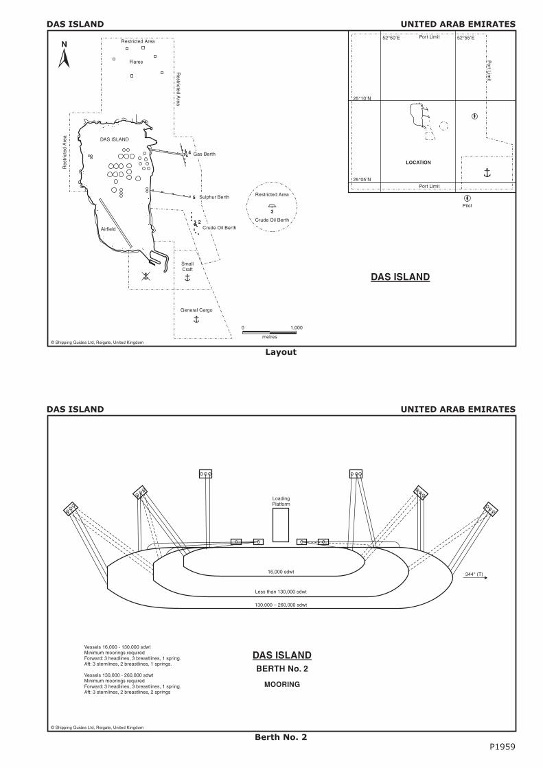
DAS ISLAND UNITED ARAB EMIRATES
Layout
DAS ISLAND UNITED ARAB EMIRATES
Berth No. 2P1959
LoadingPlatform
16,000 sdwt
Less than 130,000 sdwt
130,000 – 260,000 sdwt
344° (T)
DAS ISLANDBERTH No. 2
MOORING
Vessels 16,000 - 130,000 sdwtMinimum moorings requiredForward: 3 headlines, 3 breastlines, 1 spring.Aft: 3 sternlines, 2 breastlines, 1 springs.
Vessels 130,000 - 260,000 sdwtMinimum moorings requiredForward: 3 headlines, 3 breastlines, 1 spring.Aft: 3 sternlines, 2 breastlines, 2 springs
© Shipping Guides Ltd, Reigate, United Kingdom
© Shipping Guides Ltd, Reigate, United Kingdom
Flares
3
4
2
5
Restricted
Area
Restricted Area
Crude Oil Berth
DAS ISLAND
Airfield
25°10 N’
25°05 N’
52°50 E’ 52°55 E’
LOCATION
Pilot
Gas Berth
Crude Oil Berth
Sulphur Berth
DAS ISLAND
Res
tric
ted
Are
a
SmallCraft
General Cargo
0 1,000
metres
Port Limit
PortLim
it
Port Limit
Restricted Area
Page 6
DAS ISLAND UNITED ARAB EMIRATES
Berth No. 4
FATEH TERMINAL UNITED ARAB EMIRATES
LayoutP1960
G
54° 20 00 E’ ”
25° 40 00 N’ ”
54° 25 00 E’ ” 54° 30 00 E’ ”
RO
ZBI
ZC
Q
F
E
M
Water
Oil
Gas
SBM 2
Oil
W
SBM 1
Oil
DugasDugasDugas
Dugas
ZD
Wat
er
N
Water
V
B
Gas O
il
Oil Al Wasel
Oil
OilGas
Wat
er
Tanker Anchorage
IRAN
DUBAI
FATEH FIELD
ZAU D
Oil G
asO
il
Oil
Gas
Wat
er
OilOil
Water
Water
Water
Gas
Gas
S
Gas
Oil
C
Oil
Oil
Oil
P
Oil
Gas
Oil
OilOil
To onshore Dubai processing facilities
Rashid Field
FATEH TERMINAL
Wate
r
Gas
Existing DPC Platform
Proposed DPC Platform
Water
H
© Shipping Guides Ltd, Reigate, United Kingdom
S.W. F
ateh Field
Jetty approach arm
MD 4
MD 3
MD 2
MD 1
MD 5
MD 6
MD 7
Liquid loading platform
BD 1
BD 2
BD 4
BD 5
BD 3
Berthing dolphins withdouble quick release hooks.Capacity 100 tonnes each.
Breasting line
DAS ISLANDBERTH No. 4
135,000 cu. m LNG
125,000 cu. m LNG
79,900 cu. m LPG
Mooring Requirements
135,000 cu. m LNGForward Aft2 headlines 2 sternlines4 breastlines 4 breastlines2 springs 2 springs
Note: Wires to be fitted with 42 mm. x 124 tonne BS tails
125,000 cu. m LNGForward Aft2 headlines 2 sternlines3 breastlines 3 breastlines2 springs 2 springs
Note: Wires to be fitted with 40 mm. x 113 tonne BS tails
79,000 cu. m. LPGForward Aft2 headlines 2 sternlines2 breastlines 2 breastlines2 springs 1 spring
Note: Wires to be fitted with 34 mm. x 72 tonne BS tails
© Shipping Guides Ltd, Reigate, United Kingdom
Page 7
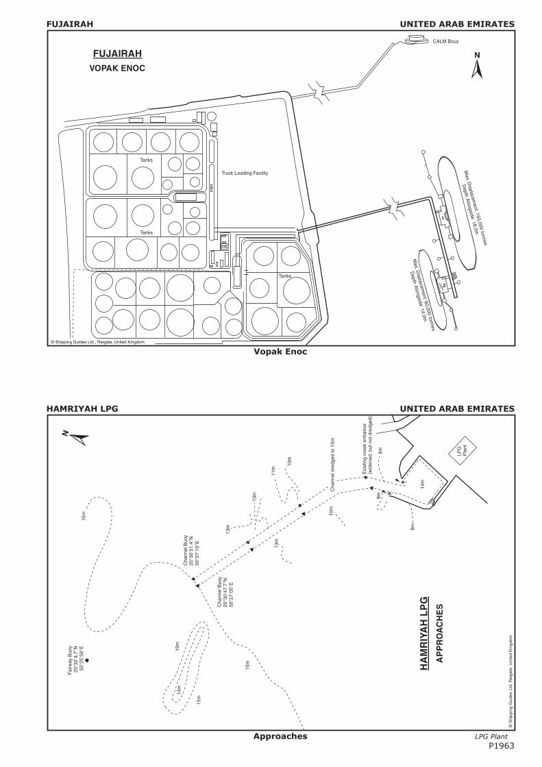
FUJAIRAH UNITED ARAB EMIRATES
Anchorage Areas
FUJAIRAH UNITED ARAB EMIRATES
LayoutP1961
Con
trol
Tow
er
Whi
teS
ecto
r
B2
B3
B1
B4
B6
B7
1
2B
5 B8
G
R
No.
4
R
Fl.G
Fl.R
7 6 4 3 2 1
Con
veyo
r
Con
tain
erTe
rmin
al
Dre
dged
to15
m(2
000)
Dre
dged
to12
.5m
(198
6)
Dre
dged
to7m
(198
6)
FU
JAIR
AH
Fuj
aira
hR
ock
&A
ggre
gate
Co.
11.5m
©S
hipp
ing
Gui
des
Ltd,
Rei
gate
,Uni
ted
Kin
gdom
Page 8
FUJAIRAH UNITED ARAB EMIRATES
Layout
FUJAIRAH UNITED ARAB EMIRATES
Vopak ENOC TerminalP1962
������������������������������������
������������������������������������
������������������������������������
������������������������������������
������������������������������������
������������������������������������
������������������������������������
������������������������������������
������������������������������������
������������������������������������
������������������������������������
������������������������������������
������������������������������������
������������������������������������
������������������������������������
������������������������������������
������������������������������������
�����������������������������������������������������������������
�����������������������������������������������������������������
�����������������������������������������������������������������
�����������������������������������������������������������������
�����������������������������������������������������������������
�����������������������������������������������������������������
�����������������������������������������������������������������
�����������������������������������������������������������������
�����������������������������������������������������������������
Page 9
FUJAIRAH UNITED ARAB EMIRATES
Vopak Enoc
HAMRIYAH LPG UNITED ARAB EMIRATES
Approaches LPG Plant
P1963
LPG
Pla
nt
14m
Exi
stin
gcr
eek
entr
ance
(wid
ened
, but
not d
redg
ed)
Fairw
ayB
uoy
25°3
24.
7N
55°2
559
E’
”
’”
Cha
nnel
Buo
y25
°30
47.7
N55
°27
05E
’”
’”
Cha
nnel
Buo
y25
°30
51.4
N55
°27
10E
’”
’”
15m
15m
15m
15m
14m
Cha
nnel
dred
ged
to15
m10
m
10m
11m
13m
13m
13m
8m
9m9m
HA
MR
IYA
HL
PG
AP
PR
OA
CH
ES
©S
hipp
ing
Gui
des
Ltd,
Rei
gate
,Uni
ted
Kin
gdom
Page 10
HAMRIYAH LPG UNITED ARAB EMIRATES
LPG Terminal
HAMRIYAH LPG UNITED ARAB EMIRATES
LPG TerminalP1964
© Shipping Guides Ltd, Reigate, United Kingdom
HAMRIYAH LPG
Roadway
Pipeway
Expansion Loop
Fire Water Pumphouse
Loading Arms
MD–1 MD–4
MD–2 MD–3
BD–1 BD–2
Breakwater
Berthing Face
40
20 14m
14m
Cen
trel
ine
Max. Length 230m
Min. Length 186m 30,000 cu.m. LPG Carrier
83,000 cu.m. LPG Carrier
3552.5 52.562.5 62.535
Tres
tle
Dimensions in metres
© Shipping Guides Ltd, Reigate, United Kingdom
Dock Level
DatumEdg
eof
Doc
k
Fen
der
Face
Inbo
ard
Arm
Outboard Arm
Fla
ngin
gA
rea
Drif
ting
Are
a
Wor
king
Are
a
Counterweight
LPG Terminal
To be reclaimed
Dredged to 14m
LPG Berth
5m
Dredged to 15m
Breakwater
5m
23.4
6.8
4.0 6.0
2.5
17.7
HAMRIYAH LPG
LPG ARM WORKING RANGELPG BERTH AND HARBOUR
Dimensions in metres
Page 11
HAMRIYAH SBM UNITED ARAB EMIRATES
Layout
HAMRIYAH SBM UNITED ARAB EMIRATES
Final Mooring ArrangementP1965
© Shipping Guides Ltd., Reigate, United Kingdom
HAMRIYAH SBMFINAL MOORING ARRANGEMENT
SupportingBuoy
MooringHawser
Anchor Chain
One Loading Hose
Buoy
Anti Chafing Chain
Triangle Plates
Special Shackle
Wire Rope Snotter Rope
Floating Hose String
Tanker
01
23
naut
ical
mile
s
Oil
LPG
10
15
20
20
15
10
Ham
riyah
SB
M
Fairw
ayB
uoy
Cha
nnel
Ent
ranc
e
HA
MR
IYA
HS
BM
Dep
ths
inm
etre
s
25°3
0N
55°3
0E’ ’
Oil
Term
inal
Ajm
an
LPG
Term
inal
LPG
Ber
th
14m
Ham
riyah
Har
bour
©S
hipp
ing
Gui
des
Ltd,
Rei
gate
,Uni
ted
Kin
gdom
Page 12
JEBEL ALI UNITED ARAB EMIRATES
Approaches
JEBEL ALI UNITED ARAB EMIRATES
Free ZoneP1966
���������������������������������������
���������������������������������������
���������������������������������������
���������������������������������������
���������������������������������������
���������������������������������������
���������������������������������������
���������������������������������������
�������������������
�������������������
�������������������
�������������������
�������������������
�������������������
�������������������
�������������������
�������������������
�������������������
�������������������
���������������
���������������
���������������
���������������
���������������
Jebe
l Ali
Ligh
t Flo
at
Fairw
ayB
uoy
Gat
e5
Gat
e6
Gat
e7
Gat
e8
Gat
e9
Gat
e10
Gat
e11
Gat
e12
Gat
e13
Gat
e14
Gat
e15
Gat
e16
Dug
as
Jebe
l Ali
Vill
age
Min
aJe
bel A
li
Dub
alP
ower
Sta
tion
Min
aS
eyah
a
ToD
ubai
App
roac
hC
hann
el
GasPipelinetoAlFatehField
Dre
dge
Spo
ilD
ispo
sal A
rea
UTMBearing315°
Has
sah
Mar
ina
Jebe
l Ali
Hot
el
ToA
buD
habi
Sca
lein
Km
.
03
12
JEB
EL
AL
I
©S
hipp
ing
Gui
des
Ltd,
Rei
gate
,Uni
ted
Kin
gdom
Page 13
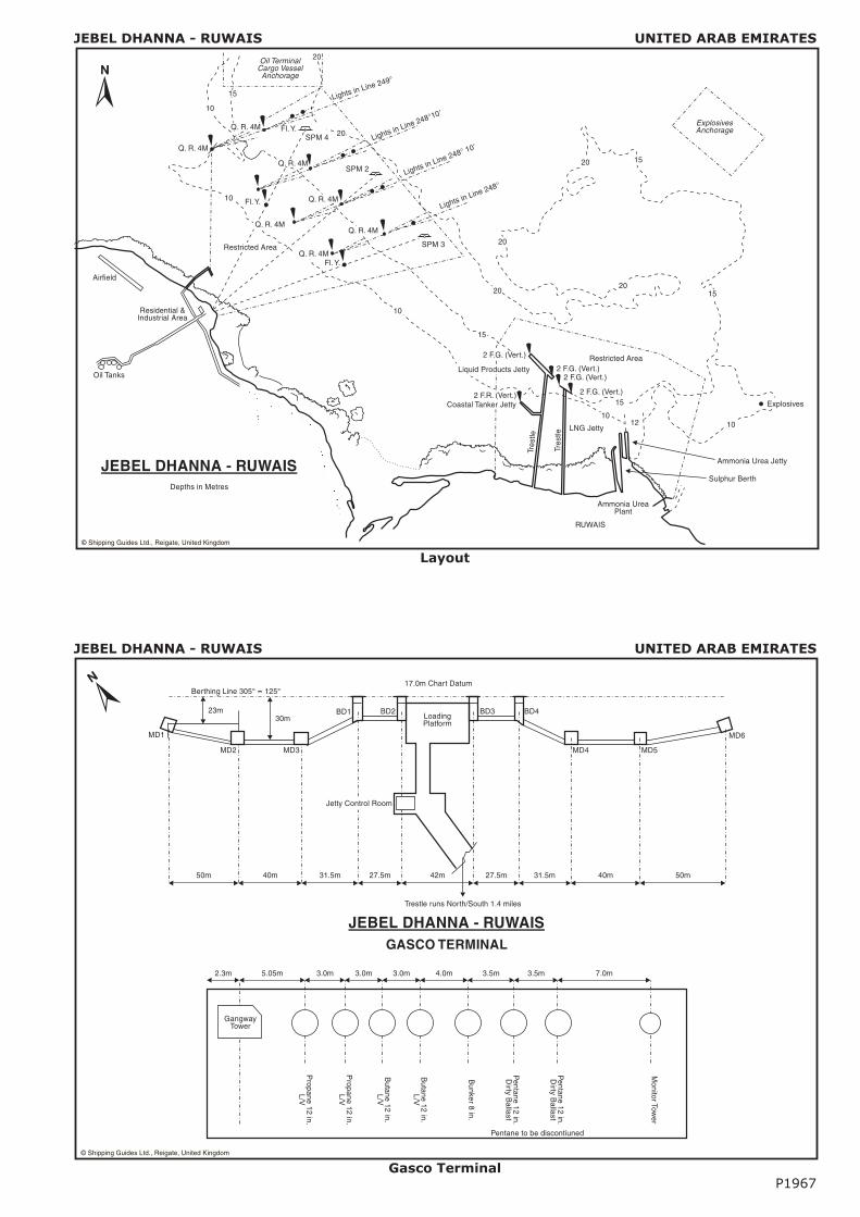
JEBEL DHANNA - RUWAIS UNITED ARAB EMIRATES
Layout
JEBEL DHANNA - RUWAIS UNITED ARAB EMIRATES
Gasco TerminalP1967
JEBEL DHANNA - RUWAISGASCO TERMINAL
GangwayTower
Propane
12in.
L/V
Propane
12in.
L/V
Butane
12in.
L/V
Butane
12in.
L/V
Bunker
8in.
Pentane
12in.
Dirty
Ballast
Pentane
12in.
Dirty
Ballast
MonitorTow
er
2.3m 5.05m 3.0m 3.0m 3.0m 4.0m 3.5m 3.5m 7.0m
Pentane to be discontiuned
50m 40m 31.5m 27.5m 42m 27.5m 31.5m 40m 50m
23m30m
MD1
MD2 MD3 MD4 MD5
MD6
BD1 BD2 BD3 BD4LoadingPlatform
17.0m Chart DatumBerthing Line 305° -- 125°
Trestle runs North/South 1.4 miles
Jetty Control Room
© Shipping Guides Ltd., Reigate, United Kingdom
Oil TerminalCargo VesselAnchorage
20
20
10
10
1012 10
15
15
15
15
20
20
20
2 F.G. (Vert.)
2 F.G. (Vert.)2 F.G. (Vert.)
2 F.G. (Vert.)2 F.R. (Vert.)Coastal Tanker Jetty
Ammonia Urea Jetty
Explosives
Sulphur Berth
Ammonia UreaPlant
RUWAIS
Restricted Area
ExplosivesAnchorage
LNG Jetty
Tres
tle
Tres
tle
Q. R. 4M
Q. R. 4M
Residential &Industrial Area
Airfield
Oil Tanks
SPM 3
Lights in Line 248°
Lights in Line 249°
Lights in Line 248° 10’
Lights in Line 248°10’
Q. R. 4M
Q. R. 4M
Q. R. 4M
Q. R. 4M
Fl.Y.
Fl.Y.
Fl.Y.
JEBEL DHANNA - RUWAISDepths in Metres
Restricted Area
SPM 4
Liquid Products Jetty
20
10
15
Q. R. 4M
© Shipping Guides Ltd., Reigate, United Kingdom
SPM 2
Page 14
JEBEL DHANNA - RUWAIS UNITED ARAB EMIRATES
Refinery Berth E
JEBEL DHANNA - RUWAIS UNITED ARAB EMIRATES
Urea BerthP1968
© Shipping Guides Ltd., Reigate, United Kingdom
Shiploader Details
100 tonneBeam Bollard
25,000 dwt Bulk Carrier
Dredged to 12m
Sup
port
Pile
s
Fen
der
Pile
CROSS SECTION
PLAN
Sub Station
Loader Rails
Dredged to 12 m.
Jetty Landing Stage
Cabin
Mooring Dolphins
Loading Area
JEBEL DHANNA - RUWAIS
UREA BERTH
Fender Pile
Ammonia Loading Arm
JEB
EL
DH
AN
NA
-R
UW
AIS
RU
WA
ISR
EF
INE
RY
TE
RM
INA
LB
ER
TH
-E
4.8m 3m 3m 3m 3m 3m 3m 3m 3m 3m 3m 3m 2m
Gan
gway
Tow
er
P&
RG
asol
ine
Gas
Oil/
Ker
o
Gas
Oil/
Ker
o
Con
dens
ate
/ Nap
htha
Pen
tane
Plu
s
Con
dens
ate
/ Nap
htha
Pen
tane
Plu
s
Cru
deO
il/ B
alla
stF
uel O
il
Cru
deO
il/ B
alla
stF
uel O
il
Cru
deO
il/ B
alla
stF
uel O
il
Bun
ker
"C"
/ MD
O
Bun
ker
"C"
/ MD
O10
in.
12in
.
12in
.
12in
.
12in
.
16in
.
16in
.
16in
.
16in
.
12in
.
LO
AD
ING
AR
MP
LA
TF
OR
M
©S
hipp
ing
Gui
des
Ltd.
, Rei
gate
,Uni
ted
Kin
gdom
Page 15
JEBEL DHANNA - RUWAIS UNITED ARAB EMIRATES
Development
KHOR FAKKAN UNITED ARAB EMIRATES
LayoutP1969
Dre
dged
to14.6
5m
Dre
dged
to12.2
5m
Dre
dged
to11
.65
m
Dre
dged
to16m
Sh
all
ow
Are
a7m
Fis
hin
gH
arb
ou
r
10
15
20
25
20
51
01
520
5
510
15
20
15
10
5
Turn
ing
Cir
cle
Dre
dged
to16m
Kh
or
Fa
kka
nB
ay
ProhibitedAnchorageArea125
°21
50’”
25°2
1’
25°2
250’
”
25°2
2’
25°2
3’
25°2
150’
”
25°2
1’
25°2
250’
”
25°2
2’
25°2
3’
56°2
3’56
°22
50’”
56°2
2’
56°2
3’56
°22
50’”
56°2
2’56
°21
50’”
FW
B
Iso.
10s
Buo
y1
Q.G
Buo
y2
Buo
y3
Buo
y4
Buo
y5 B
uoy
6
Buo
y7
Q.G
Fl.G
Q.G
Fl.G
Fl.G
Fl.G
Q.R
Buo
y9
Buo
y8
Q.G
Q.R
War
ning
Bea
con
War
ning
Bea
con
(to
bein
stal
led
byF
eb.2
007)
Sira
t al K
hor
Isla
nd
Con
tain
erTe
rmin
al
Berth1
Berth2
Berth3
Berth4
Loca
lC
raft
Jetty
Dho
wJe
tty
Bre
akw
ater
New Breakwater
Berth5
Dep
ths
inm
etre
s
Q.R
©S
hipp
ing
Gui
des
Ltd,
Rei
gate
,Uni
ted
Kin
gdom
020
040
060
0m
N
KH
OR
FAK
KA
N
©S
hipp
ing
Gui
des
Ltd.
, Rei
gate
,Uni
ted
Kin
gdom
Tu
rnin
gA
rea
300m
diam
eter
Bas
inD
redg
edto
7.5m
JEB
EL
DH
AN
NA
-R
UW
AIS
DE
VE
LO
PM
EN
T
Dep
ths
inm
etre
s
050
0
met
res
Pilo
t Sta
tion
9.0
8.0
7.0
6.0
5.0
4.0
3.0
2.0
0.02.
0
2.0 2.
0
8.0
7.0
6.0
5.0
4.0
3.0
4.0
1
2
34
56
7
9
8 10
Future extension dredged to 9.5m
Dredged to 7.5m 120m
Bre
akw
ater
Ext
ensi
on
Page 16
MINA SAQR UNITED ARAB EMIRATES
Layout
MINA ZAYED UNITED ARAB EMIRATES
LayoutP1970
Fishin
gHarb
our
Sea
Win
gC
hann
el
TurningCircle
Khaw
rBaghal C
hannel
Free Port
Customs W
all
To Abu Dhabi
ContainerTerminal
SadiyatIsland
19
15
16
17
18
1412 13
11 10 8
7
6
5
ContainerTerminal 20
21
22
23
24
25
1
2
3
4Free Zone Area
26
27
28
Warehouses
Mosque
© Shipping Guides Ltd, Reigate, United Kingdom
0 500 1000m
N
MINA ZAYED
Shed
1
Shed
2
Shed
3
Conta
iner S
tora
geAre
a
1
2
3
Quay No. 1A4
Ro-R
oR
amps
Quay No. 1
5
6
7
8
Quay No. 2
Shed 4
Shed 5
Leading Light
SmallBoats
Fishing Harbour
Aggregate Export Berth
9
Quay No. 3
Inchcape ShipServices
Bulk Cement Berth
RAK Cement
GCC
Overhead ConveyorOverhead Conveyor
Police
Port AuthorityOffices
EGPC Oil Terminal
RAK Cement
Gulf Cement
ADNOC FODTerminal
MINA SAQR
30m
20m
ANCHORAGE
Dredged to 12.2m LAT
Gas Pipeline
© Shipping Guides Ltd, Reigate, United Kingdom
Page 17
MUBAREK TERMINAL UNITED ARAB EMIRATES
Layout
MUBARRAZ ISLAND UNITED ARAB EMIRATES
LayoutP1971
©S
hipp
ing
Gui
des
Ltd.
, Rei
gate
,Uni
ted
Kin
gdom
MU
BA
RR
AZ
ISL
AN
D
Approach Channel
Appr
oach
Cha
nnel
Zaqq
umTr
affic
Sep
erat
ion
Sch
eme
Zaq
qu
mO
ilfie
ld
Zaq
qum
Oilf
ield
Lim
its
Mu
bar
raz
Oilf
ield
Mub
arra
zO
ilfie
ldLi
mits
Ru
qq
alH
alj
Drie
sat
Low
Wat
er
Buoy
edCha
nnel
Oil
Lo
adin
gTe
rmin
al
Mu
bar
raz
Isla
nd
20
20
20
20
10
10 1010
10
10
10
10
2020
Mub
arra
zE
ntry
Mub
arra
zA
ppro
ach
All
Dep
ths
inM
etre
s
Oil
Pla
tform
s
Expo
rtTa
nker
Oil
Load
ing
Hos
e(1
,400
ft.)
Bow
toB
ow
Anc
hor
Pile
Oil
Pipe
line
(30
in.)
TU
RR
ET
MO
OR
ING
AR
RA
NG
EM
EN
T
25°
46N
’
25°
55N
’
55°04E’
55°18E’
An
ch
ora
ge
Are
a
Ves
sel m
ust n
oten
ter
this
area
with
out a
Moo
ring
Mas
ter
onbo
ard
Sto
rage
Ves
sel
Pla
tform
Fla
re
Pla
tform
RE
ST
RIC
TE
DA
RE
A
MU
BA
RE
KT
ER
MIN
AL
Mubara
ka
FSU
Turr
et
©S
hipp
ing
Gui
des
Ltd,
Rei
gate
,Uni
ted
Kin
gdom
Page 18
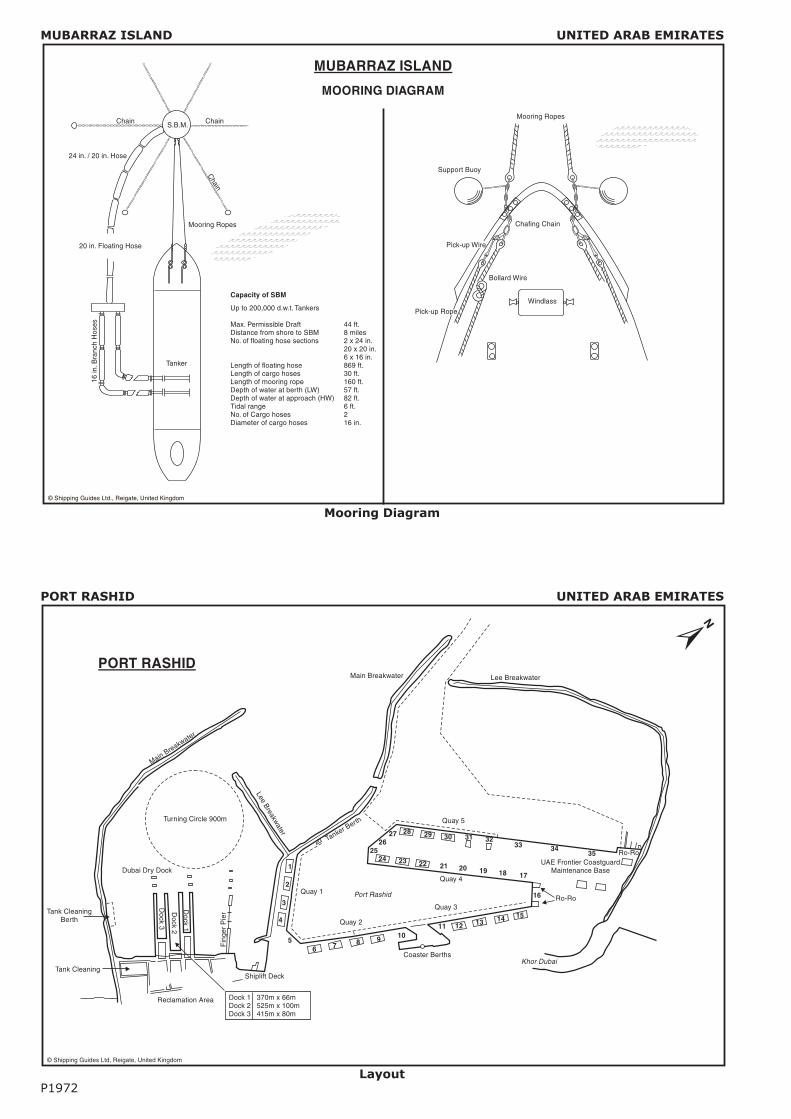
MUBARRAZ ISLAND UNITED ARAB EMIRATES
Mooring Diagram
PORT RASHID UNITED ARAB EMIRATES
LayoutP1972
Lee BreakwaterMain Breakwater
Tanker Berth
UAE Frontier CoastguardMaintenance Base
Ro-Ro
Port Rashid
LeeBreakw
ater
353433
32313029282726
2524 23 22 21 20 19 18 17
16
1514131211109876
5
4
3
2
1
Ro-Ro
Khor DubaiCoaster Berths
Shiplift Deck
Fin
ger
Pie
r
Dock
1
Dock
2
Dock
3
Reclamation Area Dock 1 370m x 66mDock 2 525m x 100mDock 3 415m x 80m
Tank Cleaning
Tank CleaningBerth
Dubai Dry Dock
Main Breakwater
Turning Circle 900m
PORT RASHID
Quay 1
Quay 4
Quay 3
Quay 5
Quay 2
© Shipping Guides Ltd, Reigate, United Kingdom
© Shipping Guides Ltd., Reigate, United Kingdom
MUBARRAZ ISLAND
MOORING DIAGRAM
Chain
Chain
Chain
Mooring Ropes
24 in. / 20 in. Hose
20 in. Floating Hose
16in
.Bra
nch
Hos
es
Tanker
Support Buoy
Mooring Ropes
Chafing Chain
Bollard Wire
WindlassUp to 200,000 d.w.t. Tankers
Max. Permissible DraftDistance from shore to SBMNo. of floating hose sections
Length of floating hoseLength of cargo hosesLength of mooring ropeDepth of water at berth (LW)Depth of water at approach (HW)Tidal rangeNo. of Cargo hosesDiameter of cargo hoses
44 ft.8 miles2 x 24 in.20 x 20 in.6 x 16 in.869 ft.30 ft.160 ft.57 ft.82 ft.6 ft.216 in.
Capacity of SBM
�������������������������
�������������������������
�������������������������
�������������������������
�������������������������
�������������������������
�������������������������
�������������������������
�������������������������
��������������������
��������������������
��������������������
��������������������
��������������������
��������������������S.B.M.
Pick-up Rope
Pick-up Wire
Page 19
SHARJAH UNITED ARAB EMIRATES
Port Khalid
UMM AL NAR UNITED ARAB EMIRATES
ApproachesP1973
Channel
No
rth
Ba
sin
Channel
So
uth
Ba
sin
Sou
thB
asin
clos
edto
ship
ping
PO
WE
RS
TAT
ION
Pow
erS
tatio
nQ
uay
ADNOC Transport and Processing Complex
Jetty
No.
1
Jetty
No.
2
©S
hipp
ing
Gui
des
Ltd,
Rei
gate
,Uni
ted
Kin
gdom
060
0m
N
AP
PR
OA
CH
ES
UM
MA
LN
AR
SH
AR
JAH
PO
RT
KH
AL
ID
Appro
ach
Cha
nnel
Dredg
edto
12m
Main Breakwater
Tank
erJe
tty
12
34567
8
1415
16
18
FAL
Fue
lD
epot
GA
DC
O
Cre
ekC
ontr
olO
ffice
Coa
stgu
ard
Creek Entrance
Eas
t Bre
akw
ater
WestBreakwater
Ro-
Ro
Ber
th
WestWharf
SharjahCreekTownQuay
Layyah Wharf
Flo
urM
ill
SC
TO
ffice
Layy
ahP
ower
Sta
tion
Con
tain
erTe
rmin
al
CF
S
Sha
rjah
Tow
nan
dB
usin
ess
Are
a
LeeBreakwater
Por
tAdm
inis
trat
ion
Bui
ldin
g
Imm
igra
tion
Offi
ce
Con
tinen
tal
Hot
el
1
2
3
46
57
8
9
1011
12
13
14
15
16
17
1 2 3 4 5 6 7 8 9 10 11 12 13 14 15 16 17
Pro
pose
dP
asse
nger
Term
inal
AT&
TE
MP
OL
ELC
OLa
mpr
ell
Tem
pera
ture
Con
trol
led
War
ehou
seC
usto
ms
Bon
ded
War
ehou
seT
iffan
yB
iscu
itsM
urra
yIn
tern
atio
nal M
etal
sIM
ID
elta
Bas
eM
ariti
me
Indu
stria
l Ser
vice
sE
mira
tes
Ref
inin
gC
ompa
nyIn
terg
ulf C
old
Sto
reP
ort K
halid
Col
dS
tore
Gul
f Agr
icul
tura
l Dev
elop
men
t Com
pany
FAL
Ene
rgy
Com
pany
19
20
21
©S
hipp
ing
Gui
des
Ltd,
Rei
gate
,Uni
ted
Kin
gdom
910
11
12
13
17
Page 20
UMM AL NAR UNITED ARAB EMIRATES
Umm Al Nar Terminal
UMM AL NAR UNITED ARAB EMIRATES
Water DepthP1974
1.86m
0.55m
4.80m
HW
LW
11.0m
3
1
UMM AL NARWATER DEPTH ALONGSIDE
All levels are relative to Admiralty Chart Datum
© Shipping Guides Ltd, Reigate, United Kingdom
1234567
Monitor Tower
3 in. 10 in. 10 in. 8 in. 6 in. 8 in. 6 in.
Monitor Tower
Gangway
Arm No.
1234567
Cargo Flexibility
Lubricating OilATKStraight Run ResidueMogasGas Oil/NaphthaStraight Run Residue/BallastFresh Water
LOADING PLATFORM
0 50 100
metres
Tug BerthJetty No. 2 Jetty No. 1
22m
24m 45m 55m 55m 45m 68m 45m 55m 55m 45m
Berthing Line
Causeway
UMM AL NARTERMINAL
50m
Shore LineShore Line
© Shipping Guides Ltd, Reigate, United Kingdom
Page 21
ZIRKU ISLAND HARBOUR UNITED ARAB EMIRATES
Zirku Island
ZIRKU ISLAND HARBOUR UNITED ARAB EMIRATES
Service HarbourP1975
10.6
mdia
.
12m
15m
11m
Road Axis
20m
15m
12m
12.5m
2m
110m
40.5m 57m
2.3m 3mRubber Fenders
15m
ZIRKU ISLAND HARBOUR
SERVICE HARBOUR
Possible location for 100 ton crane
© Shipping Guides Ltd, Reigate, United Kingdom
Loading Lines toSPM
Sea
Wat
erIn
take
Inpu
t Lin
es
Jetty
Tank
s
Pla
nt
Airf
ield
Jetty
A(D
isus
ed)
Jetty
‘B’
(Dis
used
)
Zirk
uLi
ghth
ouse
Rad
ioS
tatio
n
Qua
rry
Livi
ngA
rea
ZIR
KU
ISL
AN
DH
AR
BO
UR
Con
stru
ctio
nC
amp
ZIR
KU
ISL
AN
D
©S
hipp
ing
Gui
des
Ltd,
Rei
gate
,Uni
ted
Kin
gdom
Page 22
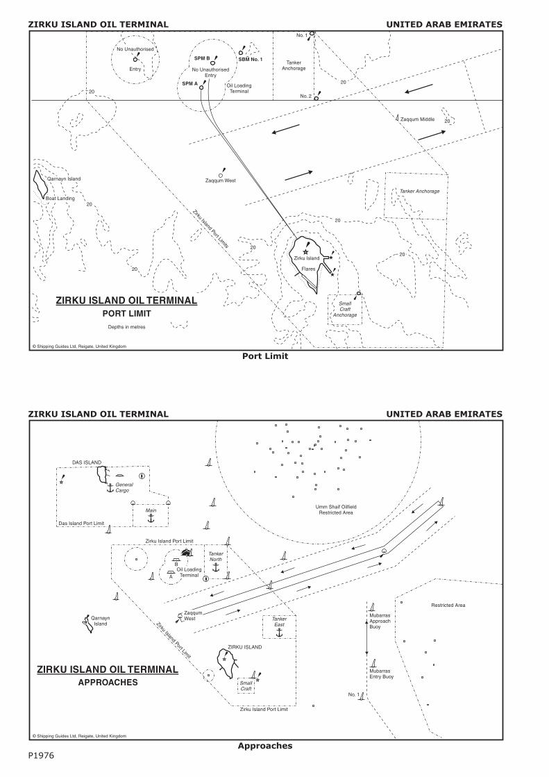
ZIRKU ISLAND OIL TERMINAL UNITED ARAB EMIRATES
Port Limit
ZIRKU ISLAND OIL TERMINAL UNITED ARAB EMIRATES
ApproachesP1976
TankerNorth
Main
SmallCraft
TankerEast
QarnaynIsland
GeneralCargo
DAS ISLAND
Das Island Port Limit
ZirkuIsland
Port Limit
A
BOil Loading
Terminal
Zirku Island Port Limit
Zirku Island Port Limit
Umm Shaif OilfieldRestricted Area
MubarrasApproachBuoy
MubarrasEntry Buoy
No. 1
ZIRKU ISLAND
ZaqqumWest
Restricted Area
ZIRKU ISLAND OIL TERMINALAPPROACHES
© Shipping Guides Ltd, Reigate, United Kingdom
20
Zaqqum West
Tanker Anchorage
SmallCraft
Anchorage
Zirku Island
Flares
Qarnayn Island
Boat Landing
Zaqqum Middle
20
No. 1
TankerAnchorage
No Unauthorised
Entry
SPM A
SPM B
No UnauthorisedEntry
SBM No. 1
Oil LoadingTerminal
No. 2
ZirkuIsland
Port Limits 20
20
20
20
20
20
Depths in metres
ZIRKU ISLAND OIL TERMINALPORT LIMIT
© Shipping Guides Ltd, Reigate, United Kingdom
Page 23
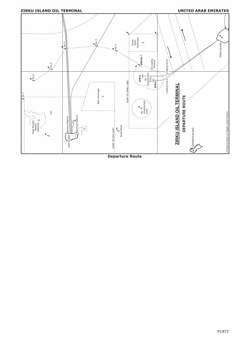
ZIRKU ISLAND OIL TERMINAL UNITED ARAB EMIRATES
Departure Route
P1977
No.
7
Tank
erN
orth
Anc
hora
ge
No
Una
utho
rised
Ent
ry
PO
RT
OF
DA
SLI
MIT
Sou
thS
hoal
Ma
inA
nch
ora
ge
Dee
pD
raug
htV
esse
ls(o
ptio
nal)
Ber
thin
gP
latfo
rm
DA
SIS
LAN
D
No.
6
No.
5
No.
4 No.
3
No.
2
SP
MB
SP
MA
No
Una
utho
rised
Ent
ry
SB
MN
o.1
QA
RN
AYN
ISLA
ND
ZIR
KU
ISLA
ND
Load
ing
Line
BLo
adin
gLi
neA
Oil
Load
ing
Term
inal
PO
RT
OF
ZIR
KU
LIM
IT
Ber
thin
gP
latfo
rm
ZIR
KU
ISL
AN
DO
ILT
ER
MIN
AL
DE
PAR
TU
RE
RO
UT
E
©S
hipp
ing
Gui
des
Ltd,
Rei
gate
,Uni
ted
Kin
gdom