Cooperative Extension Service | Agriculture and Natural Resources | Family and Consumer Sciences | 4-H Youth Development | Community and Economic Development University of Kentucky College of Agriculture, Food and Environment Cooperative Extension Service AEN-141 Maps for Farm Planning Steve Higgins and Lee Moser, Biosystems and Agricultural Engineering Introduction A s you drive through the countryside and observe farms, it is all too com- mon to see aged and outdated build- ings, fences, and roads. e associated infrastructure of these farms was often developed generations ago for purposes that may have been very different from the current operation’s needs. Full-time farming has been replaced with off-farm, full time jobs, shifting farming enterprises to part-time for many producers. The average age of existing farmers has in- creased. Combining these facts means that the average producer is less capable of keeping up with the time require- ments and physical demands of farming. e occupation of farming needs to be made more efficient and less strenuous to retain older producers and entice young producers to enter. In addition to cultural and demo- graphic changes, farms have been consolidated, split up, subdivided, or abandoned. Farms and the operators that manage them are in a state of rapid change to modernize and remain com- petitive. Planning and design are criti- cal steps when modernizing a farm to meet the current and future operational needs. Farm renovations and redevelop- ment must always consider the cost/ benefit of changes, while staying con- sistent with good agricultural practice guidelines that conserve labor and the resources of the farm. Existing facilities and infrastructure may need to be redesigned to allow tasks to be conducted more efficiently by economizing time and labor through the implementation of conservation practices. Conservation practices are techniques and structures designed to address efficient livestock care, feeding, watering, and manure management by simplifying tasks, which in turn con- serves resources of time, money, labor, energy, fuel, soil, water, and forages. ese practices also focus on producer and livestock safety concerns. Cataloguing existing and planned conservation and renovation projects on maps is a critical first step in the farm planning process. e process of developing a farm map will be used to guide producers on the concepts and considerations necessary to make decisions related to planning renovations and developing new infra- structure on the farm. Developing a Map for Farm Planning e best place to start when evaluat- ing a farming operation is a map. Useful information that should be mapped includes, but is not limited to: soils, to- pography, drainages, wet areas, rock piles or outcroppings, shade trees, wooded areas, ponds, floodplains, existing build- ings, fences, gates, lanes, waterers, and winter feeding areas as they presently exist. Aerial imagery would be very ben- eficial in depicting locations of features. Additionally, localized area maps are extremely useful to show planned modi- fications, renovations, and additions to the farmstead. Maps get busy quickly, so try not to add too many things to a single map. Instead, opt for creating a series of maps, each with a specific topic, theme, or purpose. As things change, update maps. Keep the new copy with old cop- ies, sketches, and supporting documents in a three-ring-binder. Put this binder in a location where you can easily access it and make notes for future modifica- tions, as they come to mind. Developing and maintaining maps digitally (using computer software) provides additional flexibility for modification, storage, and sharing. An overview of digital mapping options and techniques will be provided within this document, along with links to tutorials and additional resources.
Transcript
Cooperative Extension Service | Agriculture and Natural Resources | Family and Consumer Sciences | 4-H Youth Development | Community and Economic Development
University of KentuckyCollege of Agriculture,Food and EnvironmentCooperative Extension Service
AEN-141
Maps for Farm PlanningSteve Higgins and Lee Moser, Biosystems and Agricultural Engineering
Introduction
As you drive through the countryside and observe farms, it is all too com-
mon to see aged and outdated build-ings, fences, and roads. The associated infrastructure of these farms was often developed generations ago for purposes that may have been very different from the current operation’s needs. Full-time farming has been replaced with off-farm, full time jobs, shifting farming enterprises to part-time for many producers. The average age of existing farmers has in-creased. Combining these facts means that the average producer is less capable of keeping up with the time require-ments and physical demands of farming. The occupation of farming needs to be made more efficient and less strenuous to retain older producers and entice young producers to enter. In addition to cultural and demo-graphic changes, farms have been consolidated, split up, subdivided, or abandoned. Farms and the operators that manage them are in a state of rapid change to modernize and remain com-petitive. Planning and design are criti-cal steps when modernizing a farm to meet the current and future operational needs. Farm renovations and redevelop-ment must always consider the cost/benefit of changes, while staying con-sistent with good agricultural practice guidelines that conserve labor and the resources of the farm. Existing facilities and infrastructure may need to be redesigned to allow tasks to be conducted more efficiently by economizing time and labor through the implementation of conservation practices. Conservation practices are techniques and structures designed to address efficient livestock care, feeding, watering, and manure management by simplifying tasks, which in turn con-serves resources of time, money, labor, energy, fuel, soil, water, and forages. These practices also focus on producer and livestock safety concerns. Cataloguing
existing and planned conservation and renovation projects on maps is a critical first step in the farm planning process. The process of developing a farm map will be used to guide producers on the concepts and considerations necessary to make decisions related to planning renovations and developing new infra-structure on the farm.
Developing a Map for Farm Planning The best place to start when evaluat-ing a farming operation is a map. Useful information that should be mapped includes, but is not limited to: soils, to-pography, drainages, wet areas, rock piles or outcroppings, shade trees, wooded areas, ponds, floodplains, existing build-ings, fences, gates, lanes, waterers, and winter feeding areas as they presently exist. Aerial imagery would be very ben-
eficial in depicting locations of features. Additionally, localized area maps are extremely useful to show planned modi-fications, renovations, and additions to the farmstead. Maps get busy quickly, so try not to add too many things to a single map. Instead, opt for creating a series of maps, each with a specific topic, theme, or purpose. As things change, update maps. Keep the new copy with old cop-ies, sketches, and supporting documents in a three-ring-binder. Put this binder in a location where you can easily access it and make notes for future modifica-tions, as they come to mind. Developing and maintaining maps digitally (using computer software) provides additional flexibility for modification, storage, and sharing. An overview of digital mapping options and techniques will be provided within this document, along with links to tutorials and additional resources.
2
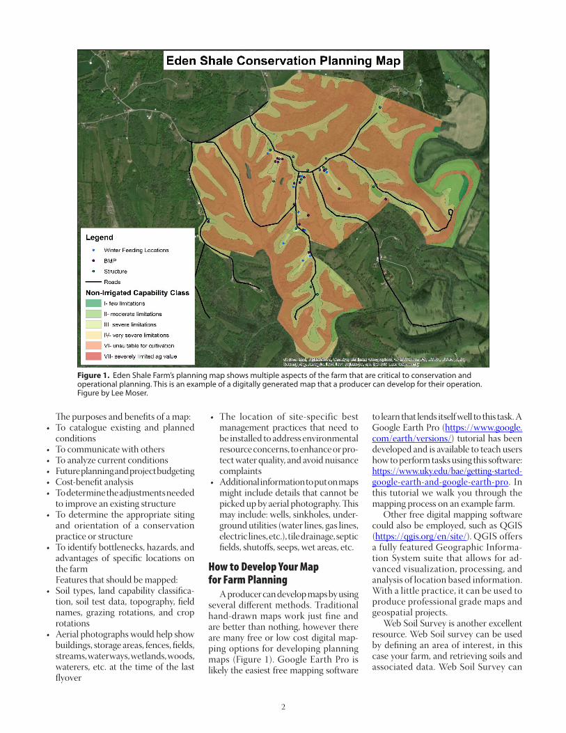
Figure 1. Eden Shale Farm’s planning map shows multiple aspects of the farm that are critical to conservation and operational planning. This is an example of a digitally generated map that a producer can develop for their operation. Figure by Lee Moser.
The purposes and benefits of a map:• To catalogue existing and planned
conditions• To communicate with others• To analyze current conditions• Future planning and project budgeting• Cost-benefit analysis• To determine the adjustments needed
to improve an existing structure• To determine the appropriate siting
and orientation of a conservation practice or structure
• To identify bottlenecks, hazards, and advantages of specific locations on the farm
Features that should be mapped:• Soil types, land capability classifica-
tion, soil test data, topography, field names, grazing rotations, and crop rotations
• Aerial photographs would help show buildings, storage areas, fences, fields, streams, waterways, wetlands, woods, waterers, etc. at the time of the last flyover
• The location of site-specific best management practices that need to be installed to address environmental resource concerns, to enhance or pro-tect water quality, and avoid nuisance complaints
• Additional information to put on maps might include details that cannot be picked up by aerial photography. This may include: wells, sinkholes, under-ground utilities (water lines, gas lines, electric lines, etc.), tile drainage, septic fields, shutoffs, seeps, wet areas, etc.
How to Develop Your Map for Farm Planning A producer can develop maps by using several different methods. Traditional hand-drawn maps work just fine and are better than nothing, however there are many free or low cost digital map-ping options for developing planning maps (Figure 1). Google Earth Pro is likely the easiest free mapping software
to learn that lends itself well to this task. A Google Earth Pro (https://www.google.com/earth/versions/) tutorial has been developed and is available to teach users how to perform tasks using this software: https://www.uky.edu/bae/getting-started-google-earth-and-google-earth-pro. In this tutorial we walk you through the mapping process on an example farm. Other free digital mapping software could also be employed, such as QGIS (https://qgis.org/en/site/). QGIS offers a fully featured Geographic Informa-tion System suite that allows for ad-vanced visualization, processing, and analysis of location based information. With a little practice, it can be used to produce professional grade maps and geospatial projects. Web Soil Survey is another excellent resource. Web Soil survey can be used by defining an area of interest, in this case your farm, and retrieving soils and associated data. Web Soil Survey can
3
Figure 2. Maps are effective tools for evaluating the time and distances associated with farm practices and projects. The map above shows time estimates to make a round trip to various winter feeding locations on a tractor traveling at ~4.5 mph with two round bales of hay. Times includes loading and unloading hay bales and time spent opening and closing gates. Figure by Lee Moser.
be accessed at: https://websoilsurvey.sc.egov.usda.gov/App/HomePage.htm. A basic tutorial of how to use Web Soil Survey and additional help resources are available at this web address. To begin a Web Soil Survey session, simply click on the large, green button that is labeled “START WSS” and follow the instructions provided on the main Web Soil Survey page. You can generate maps through Web Soil Survey’s web interface or download data for use in a standalone mapping software.
Producer Participation in the Mapping Process Studies show that producers who participate in mapping and conserva-tion planning have higher crop yields, produce more and better quality hay and pasture, feed more livestock, have higher livestock production and returns, and obtain higher farm incomes. A map serves as the visual representation of the business plan for the farm. Projected on it are the implemented practices for testing and treating the soil, how the land will be used based on land capability classes,
the plan for crop and pasture rotations, and the location of practices and controls used to manage water resources. Maps can show producers how the flow of livestock can be streamlined across the farm, through gates, and to handling facilities and winter feeding areas. NRCS and FSA can provide pro-ducers with maps with field names and boundaries free of charge. However, producers can benefit from creating and customizing their own maps. Farm fea-tures of operational importance should be included on maps that are gener-ated by the producer for their operation. When the producer participates in the mapping process they can gain a better understanding of the geography of their operation and personalize the maps to their needs. The concepts described in this pub-lication provide a logical process for documenting the current conditions of the operation and providing a plat-form to plan future modifications and investments. Projects will always exist on farms and creating functional maps should be a starting point for any plan-ning process. The plan does not need to be implemented all at once. Plans should be implemented slowly and methodically. With a well thought out plan, the work can be done at convenient times. Prefera-bly, when there are lulls in the production process. The most important projects should be prioritized and completed first. On livestock operations, winter-feeding, typically, requires the greatest expense of time and money. It is conducted when daylight is limited and when weather is challenging. Improvements to econo-mize time and feed use efficiency, while reducing mud and drudgery on livestock, such as self-feeding and other fence-line systems should be implemented before the season begins to take full advantage of good construction weather. Produc-ers will discover that there are direct and indirect benefits of implementing conservation practices. Lots of time and money can be spent fixing projects that were improperly planned. Moreover, time and money can also be wasted by not taking the time to evaluate how implementing a small project could save time and money over
the long run. Saving ten minutes per given task, twice a day, a producer will free up 122 hours over a year. Saving 12 steps a day adds up to approximately 2 miles of walking saved in a year. One-hundred and twenty steps a day equals 20 miles. Twelve-hundred steps a day equals approximately 200 miles in a year. Utilizing a map to evaluate efficiency in farm practices and projects is a critical part of the planning process (Figure 2). Think efficiency and cost-benefit in all areas of planning and operation. When developing plans, it is impor-tant that producers visit other farms and talk to other producers, extension agents, and extension specialists to develop and evaluate ideas and plans. Contact NRCS, the Conservation District, or your county Cooperative Extension Agent for technical assistance. They utilize an extensive list of conservation practices, which are all designed to increase pro-ductivity, prevent erosion, and conserve water. When possible, implement plans by using federal, state, or local cost-share practice standards, watershed projects, or personal funds to pay for infrastruc-ture improvements.
Summary Today’s producers must plan and develop operations that are operation-ally efficient, protect or enhance natu-ral resources, address nuisance issues, and make the occupation of farming more attractive to younger audiences. Utilizing maps for farm planning and the implementation of construction projects and conservation practices that reduce labor, erosion, mud, runoff, and waste should be considered a priority for all modern operations. Producers that properly manage resources such as soil, manure, and water may be able to concentrate on farming and avoid public and regulatory scrutiny. When planning to open or expand an agricultural opera-tion, producers need to be certain that their operation addresses production efficiency and current environmental regulations. An extensive amount of planning needs to occur before obtain-ing loans, or spending time, money, and energy on potentially poorly planned operations and projects. Maps for farm planning are a valuable way to address that need. Contact your local Conserva-tion District, local USDA-NRCS office, or county Cooperative Extension Agent for planning and mapping assistance.
ReferencesAmerican Society of Agricultural En-
gineers. (1981). Proceedings of the Farmstead Engineering Conference: Farmstead Engineering. Chicago, Illinois: Palmer House.
Cramer, C. O., Stombaugh, D. P., Backer, L. F., Brugger, M. F., Curtis, J. O., Dale, A. C., DeShazer, J. A., Christianson, L. L., Holmes, B. J., Manbeck, H. B., Mangold, D. W., Meador, N. F., Person, H. L. (1983). Midwest Plan Service: Structures and Environment Handbook (11th ed.). Ames, Iowa: Midwest Plan Service Iowa State University.
What is a ranch conservation plan? Soil Conservation Service. Washington, D.C. 1964.
W. I. Myers. An Economic Study of Farm Layout. 1920.