Agenda Item 5.1 DR/02/20 Report to: DEVELOPMENT & REGULATION (24 January 2020) COUNTY COUNCIL DEVELOPMENT Proposal: Interim scheme to provide a dual carriageway link road between Sheering Road and the new M11 Junction 7A, to enable Junction 7A to become operational in the period prior to the construction of the approved Phase 2B Ref: CC/EPF/65/19 Applicant: Essex County Council Location: Land between Sheering Road and the M11 Motorway Report author: Chief Planning Officer (County Planning and Major Development) Enquiries to: Tom McCarthy Tel: 03330 320943 The full application can be viewed at https://planning.essex.gov.uk Reproduced from the Ordnance Survey Map with the permission of the Controller of Her Majesty’s Stationery Office, Crown Copyright reserved Essex County Council, Chelmsford Licence L000 19602
Transcript
Agenda Item 5.1
DR/02/20 Report to: DEVELOPMENT & REGULATION (24 January 2020)
COUNTY COUNCIL DEVELOPMENT
Proposal: Interim scheme to provide a dual carriageway link road between Sheering Road
and the new M11 Junction 7A, to enable Junction 7A to become operational in the period
prior to the construction of the approved Phase 2B
Ref: CC/EPF/65/19 Applicant: Essex County Council
Location: Land between Sheering Road and the M11 Motorway
Report author: Chief Planning Officer (County Planning and Major Development)
Enquiries to: Tom McCarthy Tel: 03330 320943
The full application can be viewed at https://planning.essex.gov.uk
Reproduced from the Ordnance Survey Map with the permission of the Controller of Her Majesty’s Stationery Office, Crown Copyright reserved Essex County Council, Chelmsford Licence L000 19602
1. BACKGROUND Planning permission for Junction 7A of the M11 was granted in July 2017 (application reference: CC/EPF/08/17). The scheme (junction) was designed to assist in both the alleviation of current traffic congestion around Harlow and to meet infrastructure requirements to support development ambitions for future growth. The permission, which has been implemented/commenced, was originally scheduled to be constructed in three main phases:
• Phase 1 – widening and improvement works to Gilden Way;
• Phase 2A – the new motorway junction together with the southern arm of the link road and roundabout linking the new junction with Lower Sheering Road.
• Phase 2B – the northern arm and roundabout of the link road Extract from ‘Figure 2-3 Construction Site Layout’, drawing no. B3553F05-0000-DR-0113 (Rev P0), dated 15/12/2016 (submitted and approved pursuant to CC/EPF/08/17)
While works have commenced on phase 1, as time has passed and matters outside the immediate scope of planning and the proposal have evolved, the applicant has re-evaluated the (overall) scheme and its design to ensure best value, deliverability and outcome. In respect of this, it has been suggested (by the applicant) that it is now apparent that there is no short to medium term need for phase 2B; partly due to the anticipated phasing of emerging development and partly due to the desire to focus upon and prioritise sustainable non-motorised transport infrastructure for development to the north of Harlow (Gilston area).
Accordingly, the applicant is proposing to make changes to phase 2A to ensure that this provides a suitable link to the M11 in the short to medium term without the need for the northern (phase 2B) arm to come forward. That proposal is detailed and discussed in the proceeding sections of this report. For reference, the below plan shows the scheme as currently approved with both phases 2A and 2B. As originally envisaged, the southern arm was designed to carry westbound traffic from the new junction towards Harlow, with the northern arm carrying eastbound traffic from Harlow towards the junction/M11. Phase 2B was proposed to be constructed immediately after phase 2A with the phase 2A link therefore only being used as single lane carriageway for both directions of travel as a temporary short term solution to allow the junction to operate as soon as possible. Extract from ‘Figure 2-1 Overall Site Layout Plan Sheet 3 of 4’, drawing no. B3553F05-0000-DR-0149 (Rev P0), dated 03/01/2017 (submitted and approved pursuant to CC/EPF/08/17)
2. SITE The area to which this application relates comprises some 14ha of land (yellow line as per below aerial photograph). This application comprises a far more limited site area in comparison to the 41ha which formed part of for CC/EPF/08/17 (red line as per below aerial photograph) as the applicant also included the area required to facilitate the link road. To confirm, the application now comprises only land which was/is included in the red line for CC/EPF/08/17 with no additional land take proposed.
In terms of designations the red line application area lies solely within the administrative area of Epping Forest District. The site forms part of the Metropolitan Green Belt; lies within the safeguarding area for Stansted Airport and is partially located within flood zone 2/3, as per mapping produced by the Environment Agency. Currently, whilst planning permission has been granted for Junction 7A, as existing the land to which this application relates is open countryside in arable cultivation, noting works on this phase of the development have yet to commence. 2015 Aerial photograph showing application boundary
For completeness, albeit discussed in detail later in this report, it is confirmed that the site and surrounding area is proposed to be removed from the Green Belt within the emerging Epping Forest District Council Local Plan in support of a site allocation for comprehensive development.
3. PROPOSAL This planning application has been submitted as an interim scheme to allow the junction to operate/function, without phase 2B, and bridge the gap until such a time as there is more certainty over planned growth to require phase 2B. With respect of this, the interim proposal is to increase the phase 2A link road to a dual carriageway on a wider embankment. To facilitate this, it is also proposed to lengthen the culvert under the embankment; slightly amend the drainage pond adjacent to Campions roundabout; and make minor amendments to the access arrangements for the fields adjacent to the link road.
Extract from drawing titled ‘Figure 2-1 Alternative Phase 2A Design Overall Site Layout Plan Sheet 3 of 4’, drawing no. B3553F05-3000-DR-0703 (Rev P0), dated 12/02/19
When phase 2B is required the design is proposed to revert from this interim scheme to the scheme previous approved (including removing the additional carriageway width). Without prejudice, it has however been suggested that some elements of the interim scheme may need to remain, in perpetuity, for safety reasons; for example, reducing the width of the widened embankment in the transition between phase 2A and phase 2B may result in stability issues, so it may be preferable to retain the embankment but remove the redundant carriageway once phase 2B has been constructed. The alterations to phase 2B cannot be finalised at this time as the exact timescale for when phase will be required is uncertain. To confirm, any alternative proposals to the currently approved phase 2B would nevertheless be the subject of a fresh planning application and an associated EIA at a later date. The construction programme for phases 1 and the new phase 2A (inclusive of the interim scheme) is predicted to be 35 months. Construction hours are generally proposed from 08:00 to 18:00, with no night-time work specifically envisaged to build out the link road to which this application relates. Overnight works, for approximately two nights, would nevertheless be required to tie the new link road into the existing local road network at the Campions Roundabout. However, these works will not necessitate any road closures.
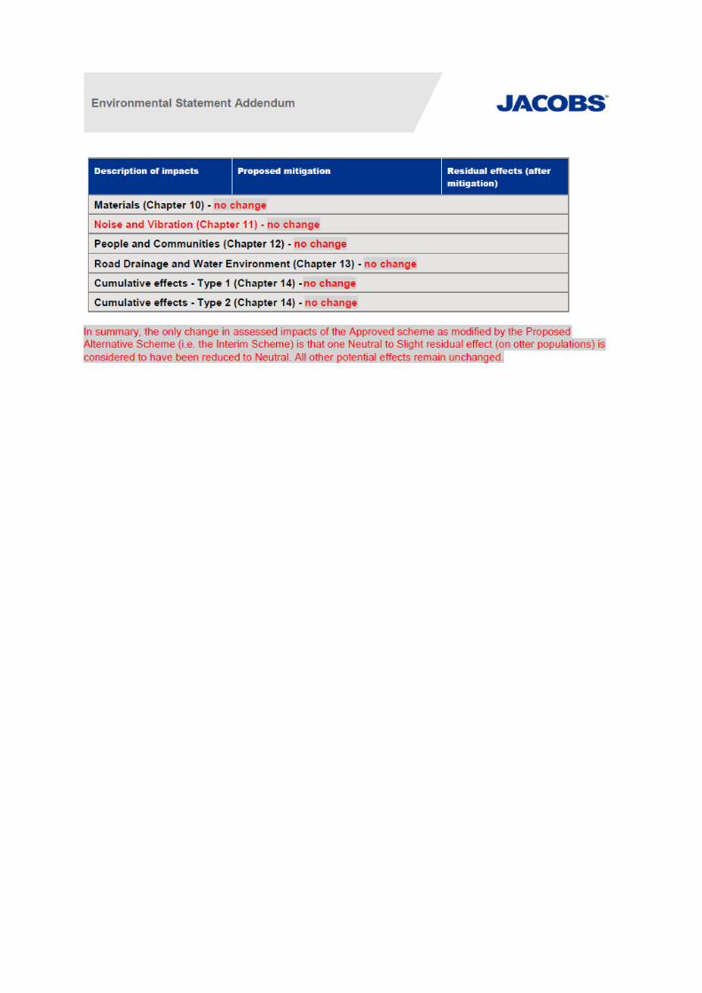
The application is accompanied by an Environmental Statement Addendum (submitted under the Town and Country Planning (Environmental Impact Assessment) Regulations 2017). A copy of the conclusions formed by the applicant for each topic considered (extract from the Non-Technical Summary) and a comparison to the existing permitted scheme is provided at Appendix 1. In addition to this an additional assessment has also been submitted which seeks to cover climate, major accidents and human health (additional topics specifically introduced by the 2017 EIA Regulations). Officers are content that the Addendum and additional assessment submitted accord with the Regulations.
4. POLICIES The following policies of the Combined Policies of the Epping Forest District Local Plan 1998 and Alterations 2006 (published 2008) (EFLP) provide the development plan framework for this application. The following policies are of relevance to this application: CP1 – Achieving Sustainable Development Objectives CP2 – Protecting the Quality of the Rural and Built Environment CP6 – Achieving Sustainable Urban Development Patterns CP9 – Sustainable Transport GB1 – Green Belt Boundary GB2A – Development in the Green Belt HC1 – Scheduled Monuments and Other Archaeological Sites NC3 – Replacement of Lost Habitat NC4 – Protection of Established Habitat RP3 – Water Quality RP5A – Adverse Environmental Impacts RST3 – Loss or Diversion of Rights of Way U1 – Infrastructure Adequacy U2A – Development in Flood Risk Areas U2B – Flood Risk Assessment Zones U3A – Catchment Effects U3B – Sustainable Drainage Systems DBE1 – Design of New Buildings DBE2 – Effect on Neighbouring Properties DBE4 – Design in the Green Belt DBE9 – Loss of Amenity LL1 – Rural Landscape LL2 – Inappropriate Rural Development LL7 – Planting Protection and Care of Trees LL8 – Works to Preserved Trees LL9 – Felling of Preserved Trees LL10 – Adequacy of Provision for Landscape Retention LL11 – Landscaping Schemes ST3 – Transport Assessment ST4 – Road Safety ST5 – Travel Plans ST7 – New Roads and Extensions or Improvements to Existing Roads ST9 – Stansted Aerodrome Safeguarding
The Revised National Planning Policy Framework (NPPF) was published in
February 2019 and sets out the Government’s planning policies for England and how these should be applied. The NPPF highlights that the purpose of the planning system is to contribute to the achievement of sustainable development. It goes on to state that achieving sustainable development means the planning system has three overarching objectives, which are interdependent and need to be pursued in mutually supportive ways: economic, social and environmental. The NPPF places a presumption in favour of sustainable development. However, paragraph 47 states that planning law requires that applications for planning permission be determined in accordance with the development plan, unless material considerations indicate otherwise. For decision-taking the NPPF states that this means; approving development proposals that accord with an up-to-date development plan without delay; or where there are no relevant development plan policies, or the policies which are most important for determining the application are out-of-date, granting permission unless: the application of policies in this NPPF that protect areas or assets of particular importance provides a clear reason for refusing the development proposed; or any adverse impacts of doing so would significantly and demonstrably outweigh the benefits, when assessed against the policies in this NPPF taken as a whole. Paragraphs 212 and 213 of the NPPF, in summary, detail that the policies in the Framework are material considerations which should be taken into account in dealing with applications and plans adopted in accordance with previous policy and guidance may need to be revised to reflect this and changes made. Policies should not however be considered out-of-date simply because they were adopted or made prior to the publication of this Framework. Due weight should be given to them, according to their degree of consistency with this Framework (the closer the policies in the plan to the policies in the Framework, the greater the weight that may be given). Paragraph 48 of the NPPF states, in summary, that local planning authorities may give weight to relevant policies in emerging plans according to the stage of preparation of the emerging plan; the extent to which there are unresolved objections to relevant policies and the degree of consistency of the relevant policies in the emerging plan to the NPPF. Epping Forest District Council submitted a replacement Local Plan to the Secretary of State for Examination in Public (EiP) on 21 September 2018. Following hearing sessions in respect of the Plan, the Inspector advised that changes to the Plan would be required to remedy issues of soundness in the form of Main Modifications. Epping Forest District Council subsequently issued a response to this advice in October 2019 and in January 2020 confirmed that they considered all actions arising from the hearing sessions was now complete. Further instruction/guidance is therefore awaited from the Inspector. At the current time, in view of the above, the emerging Plan is considered to hold limited weight in the determination of applications. Until the Plan has been sound and adopted, policies within the existing adopted Local Plan (1998) and Alterations
(2006) are considered to form the development plan. Albeit, reference (as considered appropriate) will be made to emerging plan, when appropriate, for context of future aspirations/policy positions.
5. CONSULTATIONS Summarised as follows: EPPING FOREST DISTRICT COUNCIL – No comments received. HARLOW DISTRICT COUNCIL – No comments received. NATIONAL PLANNING CASEWORK UNIT – No comments received. ENVIRONMENT AGENCY – No objection subject to the planning conditions imposed on the previous scheme being re-imposed, albeit updated as appropriate in terms of paragraph references within the NPPF. The aforementioned conditions include a remediation strategy to deal with risks associated with contamination; a verification report demonstrating the completion of works set out in the approved remediation strategy; prevention on the use of penetrative piling methods; the decommissioning of investigative boreholes; no infiltration drainage; and final details of a scheme to demonstrate if and how compensatory flood storage would be provided. NATURAL ENGLAND – No objection. Based on the plans submitted, Natural England considers that the proposed development will not have significant adverse impacts on statutorily protected nature conservation sites or landscapes. HISTORIC ENGLAND – No objection. The additional heritage assessment submitted does not seem to state any firm conclusions in terms of the level of harm to the significance of heritage assets. Although in our view, on the basis of the material that has been submitted, it would seem reasonable to conclude that the impact of the amended road scheme upon the setting of heritage assets is likely to result in harm that is less than substantial. We therefore advise that if your authority is minded to approve this planning application that it satisfies itself that any harm to significance of heritage assets that it identifies is substantiated by clear and convincing justification (NPPF paragraph 194) and that any public benefit that is delivered by the proposal is sufficient to outweigh that harm (NPPF paragraph 196). HIGHWAYS ENGLAND – No objection. HIGHWAY AUTHORITY – No objection. STANSTED AIRPORT – No objection. LEAD LOCAL FLOOD AUTHORITY – No objection subject to conditions requiring submission of a detailed surface water drainage scheme for the site; a scheme to minimise the risk of flooding caused by surface water run-off and groundwater during construction; and a maintenance plan for the surface water drainage system.
PIPELINE / COMMUNICATION / UTILITY COMPANIES – Either no comments received; no objection; no objection subjection to standard advice; or no comments to make. COUNTY COUNCIL’S NOISE, AIR QUALITY AND LIGHTING CONSULTANTS Noise – No objection subject to the inclusion of a condition mirroring Condition 20 of the existing permission which requires development of a detailed Noise Mitigation Plan. Air Quality – No objection subject to the inclusion of a condition mirroring Condition 3 of the existing permission which requires development of a Dust Management Plan. Lighting – We have reviewed the information submitted in support of the application for the Proposed Alternative Scheme and note that the designers have reduced the lighting column height in the vicinity of the culvert as per the Environmental Statement and best practice. The choice of lighting specification will theoretically force bats through the culvert so is considered acceptable. In response to an initial query regarding shielding and the 5m high fence proposed at the rear of the verge, the applicant’s agent confirmed that ‘it is necessary to read the Lighting Drawing B3553F05-1300-DR-0005 in conjunction with the Key Drawing B3553F05-1300-DR-0015 and the Environmental Addendum paragraph 8.6.2.3. Note 6 on the Key Drawing B3553F05-1300-DR-0015 states: Bat mitigation has been considered and implemented on columns NC99 – NC107 to allow a flight path; and paragraph 8.6.2.3 of the Environmental Addendum describes the bat mitigation – and includes: ‘…The luminaires adjacent to the ‘hop-over’ would be of the shorter specification (6mAGL) and shielded to prevent light spill above the horizontal, thus preserving a dark flight line in the upper canopy…’. Taking into account the clarification provided, no objection is raised to the development coming forward. COUNTY COUNCIL’S LANDSCAPE, HISTORIC BUILDINGS, ARCHAEOLOGY, ECOLOGY AND TREE CONSULTANTS – Landscape – Paragraph 170 of the NPPF highlights the need to protect and enhance valued landscapes through the planning system. Valued landscapes can be nationally and/or locally designated and/or landscapes that have valuable characteristics and qualities. For this reason, it is important to ensure that local landscape features or characteristics are respected and where possible, enhanced. In respect of this it is suggested that screening/mitigation planting should take place in advance of commencement to allow for additional time to establish; and a review of the position and design of the noise barrier should be undertaken to try and keep as many landscape features as possible or incorporate this existing planting with the noise barriers rather than removing and then replacing with alternative/new planting. In addition, a few concerns/issues are raised about number/referencing with the documents submitted. Historic Buildings – No comments to make.
Archaeology – Discussions have taken place with the applicant’s agent regarding the need to undertake appropriate archaeological investigation to allow an understanding of the significance of the heritage assets already identified and assess the impact of the scheme on these. At present a desk-based assessment and geophysical survey have been undertaken which identified a range of archaeological assets on and adjacent to the route corridor. Advice subsequently provided was that a phase of archaeological trial-trenching is required to understand the significance of these assets. At present this (trial-trenching) has not occurred and as such it is considered that the applicant does not have sufficient information to fully understand/assess potential impact. In our discussions we have already agreed that some trial trenching on those areas with a lower potential for archaeological remains can be undertaken by condition. However, this does not mean that the applicant has a full grasp of the potential large-scale archaeological mitigation that will be required if unforeseen archaeological deposits are identified. In conclusion it is our recommendation that the archaeological trial-trenching on the area of known assets is undertaken as soon as possible and that a decision is not taken on the road until this work is completed. Should a decision be made before such investigation is undertaken, is considered vital that appropriate pre-commencement conditions are secured for this work to be undertaken. Ecology – The proposed link-road changes are predominately on arable land situated between Harlow and the M11. It is understood that the proposed dual carriageway for the link road may be a temporary solution and could be removed at a later date if Phase 2B of the approved scheme is built. However, in the meantime any ecology in this area would have already been lost. Furthermore, newly created habitats may not reach their potential if the previously approved scheme is created later. The proposal to dual the link road would create a wider north-south barrier for wildlife. The Environmental Statement states that additional species surveys have been done. However, they do not appear to have been provided as part of this application, while the surveys submitted for the 2017 application (CC/EPF/08/17) have. Mindful that increasing the size/width of the link road (and embankment) potentially would create a more significant barrier for wildlife, consideration should be given to the effectiveness of the bat hop-over and the proposed multi-species underpass. In respect of this, and bats, it is noted that trees in the vicinity were assessed for bat roosts in 2014. New guidance on bats and sensitive lighting has recently been issued. It should be ensured that the proposals comply with this. In addition to the above recommendations are made in terms of the proposed landscaping; and ecological monitoring and management. Trees – Support the comments made by the landscape consultant. Whilst is its accepted that there is a need for the link road, it is to the detriment of the scheme that it will require the removal of so many good quality trees and hedges with the
associated loss of habitats, both from the rural and urban (Gilden Way/Sheering Road) parts of the site. New planting cannot entirely mitigate for the loss of historic hedges, trees and landscape features. It is recommended that given the scale of the development, an Arboricultural Clerk of Works is appointed to oversee the removal of vegetation and construction thereafter. MATCHING PARISH COUNCIL – No comments received. SHEERING PARISH COUNCIL – Suggest that detailed within the Planning Statement about timetabling and the duration of works does not take into account the effect of the current programme delays for the road widening works on Gilden Way and the availability of upgraded traffic routes suitable for construction traffic. The current utility/infrastructure works have been delayed causing the residents of Sheering and the surrounding areas extreme delays when approaching Harlow along the B183. There has also been disruption to local businesses such as the Mayfields development near to Ealing Bridge during the past two years. The Construction Phase Traffic and Transportation Impact Assessment Report states all construction traffic, including up to 250 staff vehicles, would approach the site from Harlow. Suggesting that no vehicles will be travelling from the Sheering direction towards the site, especially cars is completely unrealistic. Congestion around Harlow will result in drivers finding alternative routes through the local rural roads especially Sheering Lower Road and along the B183 through Sheering village past the local primary school. It would therefore be advantageous and perhaps realistic considering contractor's site hours, to have their office working hours staggered starting at 7am to avoid traffic congestion during school drop off and pick up times. Travel to and from the site should be restricted or ideally barred during peak hours. As for construction vehicles, the numbers of heavy vehicles have been estimated and their routes have been assumed to be via the widened B183 (A1025) into Harlow and via the M11. The impact of these traffic movements would, as far as we can find, take no account of the large increase in traffic in and out of the Gilden Park development. It is stated that the traffic routes “will be a matter for the contractor to decide” and we must insist, as a condition of the granting of planning permission, that no construction vehicles are to use any other routes but especially through Sheering and Lower Sheering. Though guidance “signage” is mentioned, as to which routes should be used, (and possibly when), it does not appear as if any sanctions could or will be imposed if these are ignored, though we are unsure if it were legally possible to enforce them. We therefore demand that if the widening of Gilden Way is not finished by the commencement date, that vehicles must be routed along the M11 and not through local roads causing further delays and pollution. Our view is that a weight restriction through our roads should be at least a temporary measure, though we would prefer It to be permanent, to restrict the routes of the vehicles should they stray from the prescribed and agreed route.
We also note that night time working is proposed on the M11, with the associated noise and light disturbance to neighbouring properties. Closure of the M11 is also proposed for a period of at least 15 days for the bridge to be installed. A 34 mile diversion route through Sawbridgeworth and Hatfield Heath is proposed for the M11 traffic, and we request that this is enforced so that traffic does not pass through Sheering and our rural roads, unless an emergency situation occurs. Whilst it is stated in the Planning Statement that night time work on the B183 and Gilden Way (Phase 1) is not anticipated, the connecting link roads from the new Campions roundabout onto the B183 are scheduled for “out of hours working”, which elsewhere is defined as 22:00 to 05:00. It would appear inevitable that access along the B183 could be further constrained during this period causing further traffic delays with the potential use of traffic lights pushing traffic to use alternative routes. As with the main development, out of hours working will cause noise and light disturbance to neighbouring properties who appear not to have received formal notification of the availability of this documentation and therefore the opportunity to comment in person. If this coincides with the scheduled “full closure” of the M11, it is difficult to envisage how there will be little increase in traffic through Sheering, albeit (possibly) for a few days. LOCAL MEMBER – EPPING FOREST – North Weald and Nazeing – No comments. LOCAL MEMBER – HARLOW – Harlow North – Any comments received will be reported.
6. REPRESENTATIONS This application was advertised by way of site notice and press advert. 16 properties were also directly notified of the application. One letter of representation has been received. This relates to planning issues, summarised as follows:
Observation Comment 100% against the link road being upgraded to a dual carriageway. The bad news keeps on coming – link road, houses, hospital and now dual carriageway.
Noted. See appraisal.
The fact that the road has been upgraded to a dual carriageway suggests that you anticipate more traffic. This will mean more noise and pollution.
See appraisal.
Negative value of my house. Property value alone is not a material planning consideration.
I am at a loss as to understand how so See appraisal.
much major development can be acceptable in an area of natural countryside, wildlife, and historical listed buildings.
7. APPRAISAL The key issues for consideration are:
• Principle of Development
• Green Belt
• Landscape, Trees and Ecology
• Heritage
• Amenity
• Flood Risk and Drainage
• Highways
PRINCIPLE OF DEVELOPMENT The NPPF at paragraph 8 when describing sustainable development states that in an economic role, the planning system should help build a strong, responsive and competitive economy, by ensuring that sufficient land of the right types is available in the right places and at the right time to support growth, innovation and improved productivity; and by identifying and coordinating the provision of infrastructure. Expanding, paragraph 81 states that policies should c) seek to address potential barriers to investment, such as inadequate infrastructure, services or housing, or a poor environment. Specifically, in terms of transport, paragraph 102 details that transport issues should be considered from the earliest stages of plan-making and development proposals, so that:
a) the potential impacts of development on transport networks can be addressed;
b) opportunities from existing or proposed transport infrastructure, and changing transport technology and usage, are realised – for example in relation to the scale, location or density of development that can be accommodated;
c) opportunities to promote walking, cycling and public transport use are identified and pursued;
d) the environmental impacts of traffic and transport infrastructure can be identified, assessed and taken into account – including appropriate opportunities for avoiding and mitigating any adverse effects, and for net environmental gains; and
e) patterns of movement, streets, parking and other transport considerations are integral to the design of schemes and contribute to making high quality places.
As outlined in the officer’s committee report when planning permission was first granted for Junction 7A, numerous studies have sought to suggest and demonstrate that Harlow is a suitable location for growth. However as noted in the Essex Transport Strategy (2011) and in-particular in Highways England’s Route
Strategy London to Leeds (2017) as existing ‘the growth of Harlow is constrained by the capacity of Junction 7’. Junction 7A was/is designed to relieve some of the congestion at Junction 7 and to improve traffic flows in and around Harlow by providing an alternative route to the north-east of the town. Without Junction 7A, albeit this is only one of a few improvement schemes proposed, future traffic congestion is expected to worsen at Junction 7 in view of forecast residential growth. In respect of this, both Harlow and East Hertfordshire Local Plans are therefore reliant on Junction 7A coming forward to support future growth and site allocations. Policy ST7 of the Epping Forest District Local Plan 1998 and Alterations 2006 (published 2008) (EFLP) relates specifically to new roads and extensions or improvements to existing roads. The policy states that such schemes should satisfy the following criteria:
i. minimal environmental impact on sensitive areas (including open countryside and its management, sites of wildlife and built heritage interest, and residential areas) with adequate compensatory measures in those cases where environmental losses are unavoidable;
ii. minimal adverse impact on road safety and traffic congestion; iii. minimal disruption to, or realignment of, the rights of way network; and iv. retention of a defensible green boundary and minimal loss of Green Belt
land. These factors are considered in the proceeding sections of the report with regard to the interim scheme. However, in more broader/principle of development terms, policy CP6 of the EFLP seeks to ensure development and economic growth comes forward in a sustainable manner to counter trends to more dispersed patterns of living, employment and travel. Whilst it is accepted that Junction 7A is proposed to support/enable new areas of growth, this is considered planned, concentrated growth to which the policy supports (albeit largely in this instance outside of the administrative area of Epping Forest). In turn the policy nevertheless suggests (iv) that priority should be given to infrastructure and transport proposals that will facilitate such development. In respect of this, and that the land to which this application relates falls within the administrative area of EFDC, EFDC within their emerging plan have acknowledged that an element of development to support growth in Harlow has likely got to take place outside of Harlow. In accepting this, and working with Harlow, the area to which this application relates within the proposals map, accompanying the emerging EFDC plan, is proposed to be removed from the Green Belt and allocated for comprehensive high quality development – site allocation: SP5.3 – East of Harlow.
Extract from Policies/Proposals Map submitted with Epping Forest District Local Plan – Submitted Version 2017
As detailed within the ‘Proposal’ section of this report, the proposed introduction of an interim phase to the development is to ensure initial deliverability and capacity in the short and medium terms. Whilst the overall impact of the interim scheme and its effectiveness, in terms of the original aspirations for Junction 7A, are discussed in the proceeding sections, no principle objection is considered to exist for this reason. This view is taken on the basis that the principle of Junction 7A is embellished in adopted and emerging policy with the extant planning permission also confirming the land use. To confirm, no additional land outside the red line of the extant planning permission is needed to facilitate the interim scheme. Whilst there may be additional or different impacts, as a result of widened dual carriageway/embankment, it is not considered that the interim scheme seeks a fundamental departure from the principle of development as established by the extant planning permission.
GREEN BELT As detailed in the NPPF the Government attaches great importance to Green Belts. The fundamental aim of Green Belt policy is to prevent urban sprawl by keeping land permanently open; the essential characteristic of Green Belts are their openness and their permanence. Paragraph 134 of the NPPF states that the Green Belt serves five purposes:
a) to check the unrestricted sprawl of large built-up areas; b) to prevent neighbouring towns merging into one another; c) to assist in safeguarding the countryside from encroachment;
d) to preserve the setting and special character of historic towns; and e) to assist in urban regeneration, by encouraging the recycling of derelict and
other urban land. Openness has furthermore been defined, through the courts, as the absence of development and as noted in the case of Timmins (paraphrased) there are clear distinctions between openness and visual impact. In principle it is wrong to arrive at a specific conclusion as to openness by reference to visual impact alone – this is just one of the considerations that forms part of the overall weighing exercise with openness as such having both spatial and visual considerations. As per paragraph 144 of the NPPF very special circumstances, to approve inappropriate development in the Green Belt, will not exist unless the potential harm to the Green Belt by reason of inappropriateness, and any other harm resulting from the proposal, is clearly outweighed by other considerations. Expanding on this paragraphs 145 and 146 detail certain forms of development that are not inappropriate provided they preserve its openness and do not conflict with the purpose of including land within it. Policy GB2A of the EFLP follows in a similar vein albeit the list of exceptions detailed within this policy is considered out of date as this does not reflect that now suggested in the NPPF. Paragraph 146 of the NPPF includes: b) engineering operations and c) local transport infrastructure which can demonstrate a requirement for a Green Belt location. Local transport infrastructure is not defined within the NPPF. However, it is noted that reference in a number of appeal decisions reviewed, nationally, has found that generally this is considered to mean physical assets which enable people and goods to move about efficiently. When planning permission was granted for Junction 7A, the officer’s report assessed the proposal (as a whole) as inappropriate development having regard to the nature, scale and location of the proposed motorway junction. It was subsequently considered that the development would conflict with the purpose of including land in Green Belt as it would not assist in safeguarding the countryside from encroachment. In granting planning permission is was however considered “that very special circumstances did exist such that the potential harm to the Green Belt by reason of inappropriateness, and any other harm (loss of trees, visual impact, lighting), was clearly outweighed by the need for the road scheme and wider public benefits taking account of the proposal to amend the Green Belt boundary in the emerging local plan”. Whilst the circumstances/justification advanced in support of this application have not fundamentally changed, it is considered that the interim scheme has the potential to give rise to additional or different impact (or harms to openness) given the enlarged embankment of the southern link road. In respect of this, noting the conclusions when planning permission was first granted, it is considered that it would wrong to suggest or consider this proposal as anything but inappropriate development. Albeit acknowledged that any re-assessment of inappropriateness, harm and very special circumstances would relate to solely the provision of the interim phase and if any additional or new
identified impacts/harms tip the scales/planning balance the other way. An assessment in respect of this and the site-specific issues associated with the interim scheme can be found below.
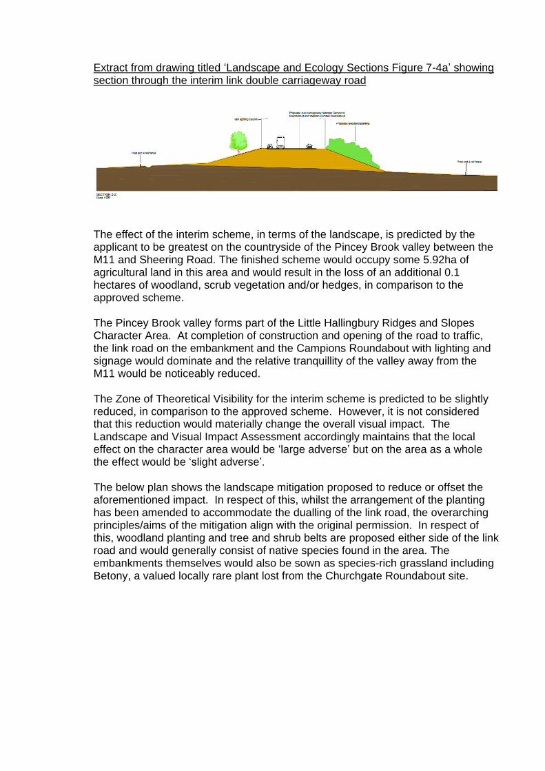
LANDSCAPE, TREES AND ECOLOGY Landscape and Trees Policy CP2 of the EFLP inter-alia aims to ensure that the quality of the rural and built environment is maintained, conserved and improved. Expanding of this policies LL1 and LL2 relate specifically to the rural landscape and inappropriate rural development with policy LL10 stating planning permission should be refused for any development which makes inadequate provision for the retention of trees; natural features, particularly wildlife habitats such as woodlands, hedgerows, ponds and watercourses; or man-made features of historical, archaeological or landscape significance. In terms of the Green Belt, policy DBE4 states that new buildings will be required to ensure their location respects the wider landscape setting of the site; and is designed to respect local character. The Environmental Statement Addendum submitted in support of this application seeks to suggest that the landscape character baseline for assessment of impact remains as considered when planning permission was first granted. In terms of assessment the Addendum has however sought to review the original Environmental Statement, with reference to the interim scheme, and in doing so assess impact during construction and during operation; consider the effectiveness of mitigation proposed and then identify any residual effects. With respect of this and construction, the proposed link would be built on an embankment close to mature trees on the north-west of Mores Wood (which is subject of a Tree Preservation Order). The embankment would not affect the trees or their root zones but a highway drainage ditch and a construction haul route along the foot of the embankment could affect parts of the root zones of trees at the corner of the wood. Some clumps of small trees, shrubs and bramble along a small stream that emerges from Mores Wood would also need to be removed to construct the link road. The interim link road would follow the same alignment of the approved southern link, albeit to facilitate this as a dual carriageway the embankment in which the road would sit would be enlarged. The height of the embankment is not however proposed to increase above levels previous approved (4.4m for the roundabouts and bridge and 8.5m for the link road).
Extract from drawing titled ‘Landscape and Ecology Sections Figure 7-4a’ showing section through the interim link double carriageway road
The effect of the interim scheme, in terms of the landscape, is predicted by the applicant to be greatest on the countryside of the Pincey Brook valley between the M11 and Sheering Road. The finished scheme would occupy some 5.92ha of agricultural land in this area and would result in the loss of an additional 0.1 hectares of woodland, scrub vegetation and/or hedges, in comparison to the approved scheme. The Pincey Brook valley forms part of the Little Hallingbury Ridges and Slopes Character Area. At completion of construction and opening of the road to traffic, the link road on the embankment and the Campions Roundabout with lighting and signage would dominate and the relative tranquillity of the valley away from the M11 would be noticeably reduced. The Zone of Theoretical Visibility for the interim scheme is predicted to be slightly reduced, in comparison to the approved scheme. However, it is not considered that this reduction would materially change the overall visual impact. The Landscape and Visual Impact Assessment accordingly maintains that the local effect on the character area would be ‘large adverse’ but on the area as a whole the effect would be ‘slight adverse’. The below plan shows the landscape mitigation proposed to reduce or offset the aforementioned impact. In respect of this, whilst the arrangement of the planting has been amended to accommodate the dualling of the link road, the overarching principles/aims of the mitigation align with the original permission. In respect of this, woodland planting and tree and shrub belts are proposed either side of the link road and would generally consist of native species found in the area. The embankments themselves would also be sown as species-rich grassland including Betony, a valued locally rare plant lost from the Churchgate Roundabout site.
Extract from drawing titled ‘Alternative Phase 2A Design Landscape Mitigation Figure 7-3a’, drawing no. B3553F05-3000-DR-0758 (Rev P01), dated Aug 19
In terms of the proposed culvert, from a landscape perspective, where the watercourse emerges from the north side of Mores Wood this would be diverted and placed into a culvert under the embankment of the interim scheme. The realigned stream would continue in a gentle curve to Pincey Brook, in contrast to the continuation of the existing course which is piped under the field. The realignment is suggested as a net landscape improvement. Overall, in context of the above, it is not considered that the proposed interim scheme would give rise to more significant landscape impacts or harm to Green Belt openness than the approved scheme. The interim scheme does not include the phase 2B link which accordingly reduces the overall land take and the mitigation/landscaping proposed to offset the widened embankment is considered in line with the principles previous established and deemed acceptable. In due course when phase 2B does come forward it is considered that there may be additional unassessed temporary landscape impacts, as a result of established landscaping mitigation potentially being lost to facilitate the construction of phase 2B. However, once constructed, the landscape mitigation deemed acceptable for the scheme originally would be required to be implemented. Accordingly, this short term impact is not considered significant in context. A condition requiring removal/decommission of the interim phase 2A link road to the original phase 2A would however be needed, should planning permission be granted, to ensure no additional landscape impact or harm to openness as a result of the enlarged
embankment. Ecology Some concern has been raised by the Council’s ecological consultant about the potential effect widening the embankment may have for wildlife. The potential barrier effect of the embankment is however proposed to offset by the extending the originally proposed species underpass tunnel and incorporating a lighting panel in the central reservation to provide additional light for the tunnel. For species such as bats, the 5m high hop overs proposed are also suggested as still being effective despite the dualling of the road which widens the gap for bats to fly over. Although it is acknowledged that mitigation would need to be monitored to ensure effectiveness, it is not considered that the proposed interim scheme would give rise to any ecological impact at a level to warrant further consideration or refusal in context of policies NC3 and NC4 of the EFLP. In respect of this, it is noted that Natural England has not objected to the development coming forward and the Environment Agency have suggested that they consider that the (ecological) assessment undertaken has been quite thorough, the mitigation appears adequate and there is Biodiversity Net Gain being delivered as an outcome.
HERITAGE No additional or differing degree of impact to any features of historic value are suggested by the applicant within the submitted Addendum to the Environmental Statement. As originally acknowledged when planning permission was first granted for the Junction, no historic buildings would be physically affected by the proposals. That said, it was considered that there would less than substantial impact on the setting of some buildings in the vicinity of the proposed scheme. As suggested by Historic England, in accordance with the NPPF, the Local Planning Authority must be satisfied, if planning permission is to be granted, that there is clear and convincing justification for the development and the harm is clearly outweighed by other public benefits. The public benefits advanced in terms of the overarching need for the development were previously considered, as part of the officer’s report for the extant planning permission, to clearly outweigh the less than substantial harm identified. Mindful of this, and that no additional harm has been identified as a result of the interim scheme, no overall objection in terms of impact to historic buildings is raised. In terms of archaeology, it is noted that the Council’s consultant has encouraged the developer to undertake on-site trial trenching upfront to further inform what may be required in terms of archaeological mitigation/preservation. The applicant did not take on board this advice. However, it is not considered that this is fundamentally a reason to refuse or defer determination. As per the extant planning permission, the use of pre-commencement conditions can seek to ensure that no development occurs until the aforementioned archaeological investigation
has been undertaken. Should this subsequently reveal something unexpected, this would be for the applicant to consider in terms of implications on the planning permission. To confirm, subject to the imposition of suitable conditions it is not considered that archaeology and potential archaeological impact is a reason to refuse planning permission or defer the decision. With it is considered that conditions would seek to ensure compliance with the principles of policy HC1.
AMENITY Policy RP5A of the EFLP states that planning permission will not be granted for development where it could cause excessive noise, vibration, or air, ground water or light pollution for neighbouring land uses, protected wildlife species and habitats. A similar view is expressed in policies DBE2 and DBE9 in terms of consideration as to potential loss of residential amenity. Noise The original noise and vibration assessment submitted in support of the extant planning permission was based upon modelled traffic data. Although the interim scheme makes some changes to the link road alignment from Campions Roundabout to the motorway junction western dumbbell roundabout, it is considered by the applicant that these design changes would not lead to any material change in terms of scheme traffic flows (see Highways section for further commentary). The Council’s noise consultant on receipt of the above, and suggested no change in terms of impact, sought clarification at whether any additional plant would be used during construction. The applicant confirmed that no additional or specialised plant or equipment would be required. In fact, it was suggested that volume of earthworks would actually reduce as would construction traffic numbers. Albeit accepted that when phase 2B comes forward these impacts would still result. Additionally, noting the removal of the northern link clarification was requested on the impact of bringing all traffic onto the southern link alignment to nearby receptors. An assessment and predictions for receptors closest to the southern link was subsequently undertaken. This utilised the new highway design and traffic modelling undertaken in 2018 (to give the most up to date available picture although it is accepted that this does slightly confuse comparison with the extant scheme). The results as shown below, show that comparing the do minimum to the do something (i.e. the scheme), all properties with the exception of one would experience a decrease in noise levels. The one property that would see an increase in levels, would see a 0.1dB increase. The Council’s noise consultant considers this is unlikely to be perceptible in context and as such has raised no objection to the development coming forward subject to a condition requiring a detailed noise mitigation plan.
Air Quality Similarly, to noise the applicant initially simply sought to suggest no change to predicted air quality impact as a result of the interim scheme. Clarification was however requested from the Council’s consultant in terms of predicted changes to traffic speeds, given changes in traffic speed has the potential to give rise to air quality implications. The applicant subsequently confirmed that the revised alignment would result in a speed change for that section of road of less than 10mph and traffic flows by less than 100 Annual Average Daily Traffic (AADT). This difference in speed means that the speed band would remain the same. And, the difference in flows means that the change is below the significance threshold of 1000 AADT for air quality. On this basis, the Council’s air quality consultant has not raised an objection to the interim scheme subject to a condition requiring submission of a dust management plan as per the extant permission. Lighting A preliminary Road Lighting Layout Plan has been provided as part of this application for information only. A final lighting scheme is proposed to be developed as part of the later detailed design of the scheme by the Main Works contractor. In line with the approved scheme, the preliminary lighting proposals for the interim scheme have been designed to comply with relevant road safety requirements, to take account of energy efficiency considerations and to address potential light pollution issues. Energy efficient LED lighting is proposed to be used with lights designed to avoid lighting above the horizontal and minimise light spillage. Most lighting columns would be 10m high to achieve optimum spacing between lighting columns. However, in sensitive ecological locations, 6m columns with back shields on the luminaries are proposed to direct light away to minimise disturbance to bats. The Council’s lighting consultant has reviewed the preliminary lighting layout and notes that the designers have reduced the lighting column height in the vicinity of the culvert as per the Environmental Statement and best practice. The choice of lighting specification will theoretically force bats through the culvert so is considered acceptable. Final details of lighting specification and management is nevertheless recommended to remain a condition to be discharged in due course.
FLOOD RISK AND DRAINAGE The approved scheme included the diversion of the small stream that emerges from the north side of The Mores, and the placement of two culverts, one under each of the new link roads. The northern of these two culverts is no longer required as part of the interim scheme, as the northern link road is not there. The widened embankment of the southern link does however necessitate the lengthening of the culvert here. As currently approved the realigned stream, where it exits the culvert, would continue in a gentle curve to Pincey Brook, in contrast to the continuation of the existing watercourse which is piped under the field. The proposed culvert will be shorter in length than the existing culverted section and has been designed to accommodate high flows and encourage the passage of mammals such as otter, badgers and bats.
The surface water drainage strategy remains unchanged, with the exception of minor changes to the pond adjacent to Campions Roundabout. These changes enable the retention of some of the existing vegetation and also the minor change in access arrangement to the adjacent field. The water levels in the pond remain as approved albeit the base area of the pond has slightly increased. There is proposed no change in the concept of the drainage networks and while the catchment area is less during the lifetime of the interim scheme, the widening to the embankment to provide for the dual carriage link road has meant overall the catchment is very similar. Neither the Environment Agency or Lead Local Flood Authority have raised objection to the interim scheme coming forward subject to conditions. The Environment Agency in-particular noting that there is no significant change within the flood plain compared to the previous approved application. In their view it is also considered that the interim scheme would not give rise to an increased risk to controlled waters. The proposal is therefore considered to comply with relevant considerations of policy RP3, U2A, U2B, U3A and U3B subject to the imposition of relevant conditions.
HIGHWAYS Implementation of the scheme in two separate phases (short-term and longer-term), as now proposed, requires Phase 2A to operate without Phase 2B in the short-term. The existing traffic modelling shows that in order to ensure sufficient road capacity on the southern link in the opening year, a dual carriageway in both directions is required. In respect of this, noting the justification for not building out the approved scheme with phase 2B now and irrespective of capacity need, it has been suggested as a more medium term proposal that it is safer for traffic leaving the M11 at Junction 7A to do so onto a short length of single direction carriageway with a central reserve, rather than straight onto a two-way single carriageway link. This is acknowledged by Highways England and/or the Highways Authority in so
much that no objection has been raised to the development coming forward. The proposed interim phase accordingly is considered to comply the principles of such development coming forward contained with policies ST3, ST4 and ST7. Construction Phase A revised construction phasing plan has been submitted with this application. This seeks to update phase 2A to account for the interim scheme as:
• Section A includes the construction of a new carriageway between Mayfield Farm and new Sheering Road Roundabout (now known as ‘Campions Roundabout’). This Section is not affected by the Proposed Alternative Scheme, with the exception of Campions Roundabout and the adjacent attenuation pond; and
• Section B includes the construction of the westbound link, the M11 Eastern and Western Dumbbell Roundabouts along with the installation of an overbridge over the existing M11 spanning between the two roundabouts and the construction of the northbound and southbound merge and diverge to provide direct links to the M11. Only the link road is affected by the alternative interim scheme.
The Construction Phase Traffic & Transport Impact Assessment originally submitted with the extant permission has been re-submitted as an indication of highway impacts during construction. The level of vehicle movements is not predicted to significantly increase as a result of implementation of the revised phase 2A scheme. That said, it is accepted that in terms of impact, the baseline context for phase 2B will likely be different, without prejudice, assuming this comes forward once phase 2A is complete and operational. Extract from drawing titled ‘Construction Phasing & Programme Overview’, drawing no. B3553F05-0100-DR-0825 (Rev P1), dated 07/19
With regard to this, specifically in response to the comments received from Sheering Parish Council, it is confirmed that the submitted Assessment relates to a worst case scenario. In terms of staff movements, it was therefore assumed all would arrive during the peak am and pm, in single occupancy cars and from Harlow to give to allow a worst case scenario assessment of impact. To confirm, the modelling used also included assumptions based on planned levels of growth/future development within the area. As detailed within the Assessment temporary construction management is to nevertheless be agreed with the Main Works contractor in due course. Appropriate detail of this could however be secured by condition to ensure that issues raised by the Parish Council are duly considered as plans evolve and that the development complies with policy ST5 of the EFLP.
8. CONCLUSION This application is considered to represent inappropriate development in the Green Belt. As per the NPPF inappropriate development should only be approved in very special circumstances and such circumstances will not exist unless the potential harm to the Green Belt by reason of inappropriateness, and any other harm resulting from the proposal, is clearly outweighed by other considerations. As previously considered when planning permission was first granted for Junction 7A there is a clear need for this development not only help in terms of existing congestion within Harlow but also to enable future planned growth in the area. That said this is inappropriate development which is harmful by definition; and contrary to the purposes of the Green Belt in safeguarding the countryside from encroachment. In consideration of the policy position within emerging EFDC Local Plan and the changes/development actually proposed to support/facilitate the interim scheme it is not however considered that this would in itself further undermine the purposes of the Green Belt. It is not considered that the interim scheme would give rise to any more significant harms than previous considered/assessed. Whilst it is accepted that the embankment to which the carriageway would sit would be widened, this is only an interim scheme with the long-term intention remaining to construct the development as originally approved. The interim scheme is not considered to give rise to any more significant impacts or harms in the medium term to the approved scheme (and implementation of phases 2A and 2B as originally envisaged). In deed it is actually considered that the interim scheme is slightly less harmful to the extant planning permission given the more limited site area. In context of the above and the absence of other identified impacts, subject to appropriate mitigation and conditions, the alternative interim scheme is considered to represent sustainable development, as defined within the NPPF.
9. RECOMMENDED Subject to no intervention by the Secretary of State, pursuant to Regulation 3 of the Town and Country Planning General Regulations 1992, planning permission be granted subject to the following conditions: 1. The development hereby permitted shall be begun before the expiry of 3 years
from the date of this permission. Written notification of the date of commencement shall be sent to the County Planning Authority within 7 days of such commencement. Reason: To comply with section 91 of the Town and Country Planning Act 1990 (as amended).
2. The development hereby permitted shall be carried out in accordance with the details of the application dated 29 August 2019, together with drawings titled ‘Alternative Interim Phase 2A Site Location Plan’, drawing no. B3553F05-0100-DR-0009 (Rev P01), dated 19/07/19; ‘Alternative Interim Phase 2A Site Plan’, drawing no. B3553F05-0100-DR-0010 (Rev P0), dated 17/07/19; ‘Figure 1-1 Alternative Phase 2A Design Site Location Plan’, drawing no. B3553F05-3000-DR-0700 (Rev P0), dated 20/08/2019; ‘Figure 2-1 Alternative Phase 2A Design Overall Site Layout Plan Sheet 3 of 4’, drawing no. B3553F05-3000-DR-0703 (Rev P0), dated 12/02/2019; and ‘Figure 2-1 Alternative Phase 2A Design Overall Site Layout Plan Sheet 4 of 4’, drawing no. B3553F05-3000-DR-0704 (Rev P0), dated 12/02/2019 and in accordance with any non-material amendment(s) as may be subsequently approved in writing by the County Planning Authority, except as varied by the following conditions. Reason: For the avoidance of doubt as to the nature of the development hereby permitted, to ensure development is carried out in accordance with the approved application details, to ensure that the development is carried out with the minimum harm to the local environment and in accordance with polices CP1 (Achieving Sustainable Development Objectives), CP2 (Protecting the Quality of the Rural and Built Environment), CP6 (Achieving Sustainable Urban Development Patterns), CP9 (Sustainable Transport), GB1 (Green Belt Boundary), GB2A (Development in the Green Belt), HC1 (Scheduled Monuments and Other Archaeological Sites), NC3 (Replacement of Lost Habitat), NC4 (Protection of Established Habitat), RP3 (Water Quality), RP5A (Adverse Environmental Impacts), RST3 (Loss or Diversion of Rights of Way), U1 (Infrastructure Adequacy), U2A (Development in Flood Risk Areas), U2B (Flood Risk Assessment Zones), U3A (Catchment Effects), U3B (Sustainable Drainage Systems), DBE1 (Design of New Buildings), DBE2 (Effect on Neighbouring Properties), DBE4 (Design in the Green Belt), DBE9 (Loss of Amenity), LL1 (Rural Landscape), LL2 (Inappropriate Rural Development), LL7 (Planting Protection and Care of Trees), LL8 (Works to Preserved Trees), LL9 (Felling of Preserved Trees), LL10 (Adequacy of Provision for Landscape Retention), LL11 (Landscaping Schemes), ST3 (Transport Assessment), ST4 (Road Safety), ST5 (Travel Plans), ST7 (New Roads and Extensions or Improvements to Existing Roads) and ST9 (Stansted Aerodrome Safeguarding) of the Combined Policies of the Epping Forest District Local Plan 1998 and Alterations 2006 (published 2008).
3. No development shall take place until a detailed landscape scheme has been
submitted to and approved in writing by the County Planning Authority. The scheme shall be based on the drawing titled ‘Alternative Phase 2A Design Landscape Mitigation Figure 7-3a’, drawing no. B3553F05-3000-DR-0758 (Rev P01), dated Aug 19 and include details of areas to be planted with species, sizes, spacing, protection; proposed seed mix for grassed areas; and programme of implementation. The scheme shall, for reference, also include details of all existing trees and hedgerows on site proposed to be retained for context. The landscape scheme shall be implemented within the first available planting season (October to March inclusive) following commencement (or completion) of the development hereby permitted in accordance with the approved details. Any tree or shrub forming part of a landscaping scheme approved in connection with the development that dies, is damaged, diseased or removed within the duration of 5 years during and after the completion of the development shall be replaced during the next available planting season (October to March inclusive) with a tree or shrub to be agreed in advance in writing by the County Planning Authority. Reason: To comply with section 197 of the Town and Country Planning Act 1990 (as amended), to improve the appearance of the site in the interest of visual amenity and to mitigate impacts of the development on the natural environment in accordance with polices CP1 (Achieving Sustainable Development Objectives), CP2 (Protecting the Quality of the Rural and Built Environment), NC3 (Replacement of Lost Habitat), NC4 (Protection of Established Habitat), RP5A (Adverse Environmental Impacts), LL1 (Rural Landscape), LL2 (Inappropriate Rural Development), LL8 (Works to Preserved Trees), LL9 (Felling of Preserved Trees), LL10 (Adequacy of Provision for Landscape Retention) and LL11 (Landscaping Schemes) of the Combined Policies of the Epping Forest District Local Plan 1998 and Alterations 2006 (published 2008).
4. No development shall take place until a Landscape and Ecological Mitigation and Management Plan has been submitted to and approved in writing by the County Planning Authority. The Plan shall include but not be limited to, in respect of landscaping:
a) Aims and objectives of management; b) Appropriate management options for achieving aims and objectives; c) Prescriptions for management actions; d) Preparation of an annual work schedule/plan; and e) Details of the body or organisation responsible for management
and for ecology:
a) Full detailed designs of the ecological mitigation measures referred in the ‘Biodiversity Statement and Mitigation Plan’, document no, B3553F05-3000-REP-0055 and shown on the drawing titled ‘Figure 8-2 Alternative Phase 2A Design Ecological Mitigation Plan, drawing no. B3553F05-3000-DR-0772 (Rev P0), dated 17/01/2019;
b) Proposed monitoring of mitigation measures and how contingencies
and/or remedial action will be identified, agreed and implemented; and c) Details of the body or organisation responsible for monitoring and
management The mitigation and management plan shall be implemented in accordance with the approved details. Reason: In the interests of the natural environment and biodiversity, to ensure appropriate design and management of mitigation, to allow the County Planning Authority to discharge its duties under the UK Habitats Regulations, the Wildlife & Countryside Act 1981 as amended and s40 of the NERC Act 2006 (Priority habitats & species) and in accordance with polices CP1 (Achieving Sustainable Development Objectives), CP2 (Protecting the Quality of the Rural and Built Environment), NC3 (Replacement of Lost Habitat), NC4 (Protection of Established Habitat), RP5A (Adverse Environmental Impacts), LL1 (Rural Landscape), LL2 (Inappropriate Rural Development), LL10 (Adequacy of Provision for Landscape Retention) and LL11 (Landscaping Schemes) of the Combined Policies of the Epping Forest District Local Plan 1998 and Alterations 2006 (published 2008).
5. No development shall take place until a detailed Noise Mitigation Plan has been submitted to the County Planning Authority for review and approval in writing. Whilst it is noted that noise mitigation barriers are not proposed within the red line of this application, it is noted that such mitigation is proposed outside the red line, as approved by application ref: CC/EPF/08/17, to offset potential impact. The mitigation plan shall furthermore confirm specification of the link road surfacing and any other measures proposed to limit noise nuisance within the application area. The development shall be implemented in accordance with the approved scheme. Reason: In the interests of residential amenity and to mitigate environmental noise impact in accordance with polices RP5A (Adverse Environmental Impacts), DBE2 (Effect on Neighbouring Properties) and DBE9 (Loss of Amenity) of the Combined Policies of the Epping Forest District Local Plan 1998 and Alterations 2006 (published 2008).
6. No development shall take place until a scheme to minimise dust emissions has been submitted to and approved in writing by the County Planning Authority. The scheme shall include details of all dust suppression measures, the methods to monitor emissions of dust arising from the development during the construction phase and shall include the mitigation measures outlined in Appendix 5.5 of the Environment Statement submitted pursuant to application ref: CC/EPF/08/17. The development shall be implemented in accordance with the approved scheme. Reason: To reduce the impacts of dust disturbance from the site on the local environment during the construction period in accordance with polices RP5A (Adverse Environmental Impacts), DBE2 (Effect on Neighbouring Properties) and DBE9 (Loss of Amenity) of the Combined Policies of the Epping Forest District Local Plan 1998 and Alterations 2006 (published 2008).
7. No fixed lighting shall be erected or installed on-site until final details of the location, height, design, luminance, operation and management have been submitted to and approved in writing by the County Planning Authority. That submitted would be expected to follow the principles suggested within the drawings titled ‘Road Lighting Layout Plan Sheet 5 of 7’, drawing no. B3553F05-1300-DR-0005 (Rev P01), dated 14/02/18; and ‘Road Lighting Key and Notes’, drawing no. B3553F05-1300-DR-0015 (Rev P01), dated 14/02/18. With regard to this, the details to be submitted shall include an overview of the lighting design, the maintenance factor and lighting standard applied together with a justification as why these are considered appropriate, detailed drawings showing the lux levels on the ground, angles of tilt, colour, temperature, dimming capability and the average lux (minimum and uniformity) for all external lighting proposed. Furthermore, a contour plan shall be submitted for the site detailing the likely spill light, from the proposed lighting, in context of the adjacent site levels. The lighting design/plan shall also consider the impact on light sensitive biodiversity and a) identify those areas/features on site that are particularly sensitive for bats and that are likely to cause disturbance in or around their breeding sites and resting places or along important routes used to access key areas of their territory, for example, for foraging; and b) clearly demonstrate that areas to be lit will not disturb or prevent the above species using their territory or having access to their breeding sites and resting places. The lighting shall thereafter be erected, installed and operated in accordance with the approved details. Reason: To minimise the nuisance and disturbances to neighbours (and the surrounding area), in the interests of highway safety, to minimise impact on light sensitive biodiversity and in accordance with polices CP2 (Protecting the Quality of the Rural and Built Environment), NC4 (Protection of Established Habitat), RP5A (Adverse Environmental Impacts), DBE1 (Design of New Buildings), DBE2 (Effect on Neighbouring Properties), DBE4 (Design in the Green Belt), DBE9 (Loss of Amenity), LL1 (Rural Landscape), LL2 (Inappropriate Rural Development), ST7 (New Roads and Extensions or Improvements to Existing Roads) and ST9 (Stansted Aerodrome Safeguarding) of the Combined Policies of the Epping Forest District Local Plan 1998 and Alterations 2006 (published 2008).
8. Prior to commencement of development, a Bird Hazard Management Plan to prevent the utilisation of the site by hazardous bird species shall be submitted to the County Planning Authority for review and approval in writing. The submitted plan shall include, but not be limited to:
• Details of measures to prevent the establishment of any colony of hazardous bird species and any dispersal methods to be used;
• Provision for the aerodrome to undertake visits to the site and make inspections (where necessary) and hold records of bird numbers; and
• Measures to limit access to attenuation ponds through the erection of goose proof fencing.
The Bird Hazard Management Plan shall be implemented as approved on completion of the development and shall remain in force in perpetuity. No
subsequent alterations to the plan are to take place unless first submitted to and approved in writing by the County Planning Authority. Reason: To avoid endangering the safe movement of aircraft and the operation of Stansted Airport through the attraction of birds and an increase in the bird hazard risk of the application site, in accordance with ST9 of the Combined Policies of the Epping Forest District Local Plan 1998 and Alterations 2006 (published 2008).
9. No development (including demolition, ground works, vegetation clearance) shall take place until a Construction and Environmental Management Plan (CEMP) has been submitted to the County Planning Authority for approval in writing. The CEMP shall be based on the Outline Environmental Management Plan, document ref: B3553-3000-REP-0056 (Rev P00.3), dated January 2017 together with that suggested in the Construction Phase Traffic & Transport Impact Assessment, document ref: B3553F05-0000-REP-0081 (Rev 1), dated January 2017. With regard to construction the plan shall cover similar areas/topics to that considered within the Construction Methodology Report, document ref: B3553F05-0000-REP-0076 (Rev P0), dated November 2016, albeit with specific reference to the development hereby permitted and construction details shown on drawings titled ‘Figure 2-4 Alternative Phase 2A Design Construction Environmental Plan Sheet 4 of 7’, drawing no. B3553F05-3000-DR-0707 (Rev P0), dated 18/02/2019; ‘Figure 2-4 Alternative Phase 2A Design Construction Environmental Plan Sheet 5 of 7’, drawing no. B3553F05-3000-DR-0708 (Rev P0), dated 28/08/2019; and ‘Figure 2-4 Alternative Phase 2A Design Construction Environmental Plan Sheet 6 of 7’, drawing no. B3553F05-3000-DR-0709 (Rev P0), dated 28/08/2019. In terms of environmental management, and specifically biodiversity, the plan shall include the following:
a) Risk assessment of potentially damaging construction activities; b) Identification of biodiversity protection zones; c) Practical measures (both physical measures and sensitive working practices) to avoid or reduce impacts during construction (may be provided as a set of method statements); d) The location and timing of sensitive works to avoid harm to biodiversity features; e) The times during construction when specialist ecologists need to be present on site to oversee works; f) Responsible persons and lines of communication; g) The role and responsibilities on site of an ecological clerk of works or similarly competent person; and the h) Use of protective fences, exclusion barriers and warning signs.
The approved CEMP shall be implemented and adhered to throughout the construction period of the development hereby approved.
Reason: In the interests of highway safety and amenity, to make appropriate provision for conserving biodiversity during construction and in accordance with
polices CP1 (Achieving Sustainable Development Objectives), CP2 (Protecting the Quality of the Rural and Built Environment), NC4 (Protection of Established Habitat), RP3 (Water Quality), RP5A (Adverse Environmental Impacts), DBE2 (Effect on Neighbouring Properties), DBE4 (Design in the Green Belt), DBE9 (Loss of Amenity), LL1 (Rural Landscape), LL2 (Inappropriate Rural Development), LL7 (Planting Protection and Care of Trees), LL8 (Works to Preserved Trees), LL9 (Felling of Preserved Trees), LL10 (Adequacy of Provision for Landscape Retention), ST3 (Transport Assessment), ST4 (Road Safety), ST5 (Travel Plans) and ST7 (New Roads and Extensions or Improvements to Existing Roads) of the Combined Policies of the Epping Forest District Local Plan 1998 and Alterations 2006 (published 2008).
10. No development or any preliminary groundworks shall take place until: a) All trees to be retained during the construction works have been
protected by fencing of the ‘HERAS’ type. The fencing shall be erected around the trees and positioned from the trees in accordance with BS:5837 “Trees in Relation to Construction”, and;
b) Notices have been erected on the fencing stating “Protected Area (no operations within fenced area)”.
Notwithstanding the above, no materials shall be stored or activity shall take place within the area enclosed by the fencing. No alteration, removal or repositioning of the fencing shall take place during the construction period without the prior written consent of the County Planning Authority. Reason: In the interest of visual amenity, to ensure protection for the existing natural environment and in accordance with policies CP2 (Protecting the Quality of the Rural and Built Environment), NC4 (Protection of Established Habitat), LL1 (Rural Landscape), LL7 (Planting Protection and Care of Trees) and LL10 (Adequacy of Provision for Landscape Retention) of the Combined Policies of the Epping Forest District Local Plan 1998 and Alterations 2006 (published 2008).
11. No development or preliminary groundworks shall take place until a written scheme and programme of archaeological investigation (trial trenching) and recording has been submitted to and approved in writing by the County Planning Authority. The scheme and programme of archaeological investigation and recording shall be implemented as approved, prior to the commencement of the development hereby permitted or any preliminary groundworks. Reason: To ensure that any archaeological interest (including associated compounds and landscaping areas) has been adequately investigated and recorded prior to the development taking place and to preserve the historic environment in accordance with policy HC1 (Scheduled Monuments and Other Archaeological Sites) of the Combined Policies of the Epping Forest District Local Plan 1998 and Alterations 2006 (published 2008).
12. Prior to commencement of development but following completion of the archaeological work required by condition 11, a mitigation strategy detailing the proposed excavation/preservation strategy for areas containing archaeological deposits shall be submitted to the County Planning Authority for review and
approval and writing. No development or preliminary groundworks shall commence in these areas until the fieldwork as detailed in the mitigation strategy has been completed. With regard to this, request shall be made to the County Planning Authority for written confirmation that the aforementioned mitigation fieldwork has been satisfactorily completed before commencement of the development. Reason: To ensure development of an appropriate mitigation strategy covering both excavation (preservation by record) or preservation in situ of any archaeological features or deposits identified by the trial-trenching or geophysical survey undertaken in accordance with policy HC1 (Scheduled Monuments and Other Archaeological Sites) of the Combined Policies of the Epping Forest District Local Plan 1998 and Alterations 2006 (published 2008)
13. Within six months of completion of the programme of archaeological investigation, as approved by details submitted pursuant to condition 11, a post-excavation assessment shall be submitted to the County Planning Authority for review and approval in writing. This shall include the completion of post-excavation analysis, preparation of a full site archive and report ready for deposition at the local museum, and submission of a publication report.
Reason: To ensure that the results of the fieldwork are reported on and made available to the public in a timely and appropriate manner, in order to fulfil the requirements of preservation by record, and in accordance with policy HC1 (Scheduled Monuments and Other Archaeological Sites) of the Combined Policies of the Epping Forest District Local Plan 1998 and Alterations 2006 (published 2008).
14. No development shall take place until a remediation strategy to deal with the risks associated with contamination of the site has been submitted to, and approved in writing by, the County Planning Authority. The strategy shall include the following components: 1. A preliminary risk assessment which has identified all previous uses;
potential contaminants associated with those uses; a conceptual model of the site indicating sources, pathways and receptors; and potentially unacceptable risks arising from contamination at the site.
2. A site investigation scheme, based on (1) to provide information for a detailed assessment of the risk to all receptors that may be affected, including those off site.
3. The results of the site investigation and the detailed risk assessment referred to in (2) and, based on these, an options appraisal and remediation strategy giving full details of the remediation measures required and how they are to be undertaken.
4. A verification plan providing details of the data that will be collected in order to demonstrate that the works set out in the remediation strategy in (3) are complete and identifying any requirements for longer-term monitoring of pollutant linkages, maintenance and arrangements for contingency action
The scheme shall be implemented as approved. Reason: To ensure that the development is not put at unacceptable risk from, or adversely affected by, unacceptable levels of water pollution in line with
paragraph 170 of the NPPF.
15. Prior to commissioning/operation of development hereby permitted a verification report demonstrating the completion of works set out in the approved remediation strategy and the effectiveness of the remediation shall be submitted to, and approved in writing, by the County Planning Authority. The report shall include results of sampling and monitoring carried out in accordance with the approved verification plan to demonstrate that the site remediation criteria have been met. Reason: To ensure that the site does not pose any further risk to human health or the water environment by demonstrating that the requirements of the approved verification plan have been met and that remediation of the site is complete, in accordance with paragraph 170 of the NPPF.
16. If, during development, contamination not previously identified is found to be
present at the site then no further development (unless otherwise agreed in writing with the County Planning Authority) shall be carried out until a remediation strategy detailing how this contamination will be dealt with has been submitted to and approved in writing by the County Planning Authority. The remediation strategy shall be implemented as approved. Reason: To ensure that the development is not put at unacceptable risk from, or adversely affected by, unacceptable levels of water pollution from previously unidentified contamination sources at the development site in line with paragraph 170 of the NPPF.
17. No development shall take place until a detailed surface water drainage scheme for the site, based on sustainable drainage principles and an assessment of the hydrological and hydro geological context of the development, has been submitted to and approved in writing by the County Planning Authority. The scheme should include but not be limited to:
• Limiting discharge rates from the interim link road (including Campions roundabout) to 1l/s or the 1:1 Greenfield runoff rate (whichever is greater) for all storm events up to and including the 1 in 100 year rate plus 40% allowance for climate change.
• Provide sufficient storage in line with the design return periods shown in table 2.1 of the Drainage System Summary Report
• Final modelling and calculations for all areas of the drainage system.
• The appropriate level of treatment for all runoff leaving the site in line with the CIRIA SuDS Manual C753.
• Detailed engineering drawings of each component of the drainage scheme.
• A final drainage plan which details exceedance and conveyance routes and ground levels, and location and sizing of any drainage features.
• A written report summarising the final strategy and highlighting any minor changes to the approved strategy.
The approved scheme shall subsequently be implemented prior to commissioning and opening.
Reason: To prevent flooding by ensuring the satisfactory storage of/disposal of surface water from the site, to ensure the effective operation of SuDS features over the lifetime of the development, to provide mitigation of any environmental harm which may be caused to the local water environment and to mitigate the risk of surface water flooding and to ensure the proposed development does not result in flood risk elsewhere, in accordance with polices RP3 (Water Quality), U2A (Development in Flood Risk Areas), U2B (Flood Risk Assessment Zones), U3A (Catchment Effects) and U3B (Sustainable Drainage Systems) of the Combined Policies of the Epping Forest District Local Plan 1998 and Alterations 2006 (published 2008).
18. No development shall take place until a Surface Water Drainage System Maintenance Plan detailing the maintenance arrangements including who is responsible for different elements of the surface water drainage system and the maintenance activities/frequencies, has been submitted to and approved, in writing, by the County Planning Authority. The development shall be maintained in accordance with the approved plan. Reason: To ensure appropriate maintenance arrangements are put in place to enable the surface water drainage system to function as intended to ensure mitigation against flood risk in accordance with polices U2A (Development in Flood Risk Areas), U2B (Flood Risk Assessment Zones), U3A (Catchment Effects) and U3B (Sustainable Drainage Systems) of the Combined Policies of the Epping Forest District Local Plan 1998 and Alterations 2006 (published 2008).
19. No development shall take place until a scheme to minimise the risk of offsite flooding caused by surface water run-off and groundwater during construction works and prevent pollution has been submitted to, and approved in writing by, the County Planning Authority. The scheme shall subsequently be implemented in accordance with the approved details. Reason: Construction works may lead to excess water being discharged from the site. If dewatering takes place to allow for construction to take place below groundwater level, this will cause additional water to be discharged. Furthermore, the removal of topsoils, during construction, may limit the ability of the site to intercept rainfall and as such increased runoff rates. A construction surface water run-off management scheme is therefore required to mitigate the risks associated with this part of the development in accordance with polices RP3 (Water Quality), U2A (Development in Flood Risk Areas), U2B (Flood Risk Assessment Zones), U3A (Catchment Effects) and U3B (Sustainable Drainage Systems), of the Combined Policies of the Epping Forest District Local Plan 1998 and Alterations 2006 (published 2008).
20. No drainage systems for the infiltration of surface water drainage into the ground is permitted other than with the express written consent of the County Planning Authority, which may be given for those parts of the site where it has been demonstrated that there is no resultant unacceptable risk to controlled waters. The development shall be carried out in accordance with the approved details.
Reason: Infiltration through contaminated land and soakaways act as preferential pathways for contaminants to have the potential to impact on groundwater quality and in accordance with policy RP3 (Water Quality), of the Combined Policies of the Epping Forest District Local Plan 1998 and Alterations 2006 (published 2008).
21. Piling using penetrative methods shall not be carried out other than with the written consent of the County Planning Authority. The development shall be carried out in accordance with the approved details. Reason: To ensure that the proposed piling, does not harm groundwater resources in line with paragraph 170 of the NPPF and Position Statement G1 – Direct Inputs to Groundwater of the Environment Agency’s Groundwater Protection: Principles and Practice. Piling using penetrative methods can result in risks to potable supplies from, for example, pollution / turbidity, risk of mobilising contamination, drilling through different aquifers and creating preferential pathways. Groundwater is particularly sensitive in this location because the proposed development site is located upon Principal and Secondary A aquifers.
22. No development shall take place until a scheme to demonstrate if and how compensatory flood storage for the 1 in 100 plus 35% climate change fluvial flood event will be provided, has been submitted to and approved in writing by the County Planning Authority. The scheme will be based on the approved and verified hydraulic flood modelling. Reason: To ensure that the development is appropriately flood resilient and does not increase flood risk elsewhere, in line with paragraph 163 of the NPPF, and in accordance with policies U2A (Development in Flood Risk Areas), U2B (Flood Risk Assessment Zones), U3A (Catchment Effects) and U3B (Sustainable Drainage Systems) of the Combined Policies of the Epping Forest District Local Plan 1998 and Alterations 2006 (published 2008).
23. A scheme for managing any borehole installed for the investigation of soils, groundwater or geotechnical purposes shall be submitted to and approved in writing by the County Planning Authority. The scheme shall provide details of how redundant boreholes are to be decommissioned and how any boreholes that need to be retained, post-development, for monitoring purposes will be secured, protected and inspected. The scheme as approved shall be implemented prior to each phase of development being brought into use. Reason: To ensure that redundant boreholes are safe and secure, and do not cause groundwater pollution or loss of water supplies in line with paragraph 170 of the NPPF and Position Statement G1 – Direct Inputs to Groundwater of the Environment Agency’s Groundwater Protection: Principles and Practice.
24. Withstanding any alternative planning permission granted, prior to the commencement of works pursuant to phase 2B (the northern arm link road) as permitted by planning application ref: CC/EPF/08/17 (or any variation to this permission) a scheme shall be submitted to the County Planning Authority for review and approval in writing detailing the proposed removal/decommission works proposed for the interim phase 2A link road hereby permitted. Details provided shall include a schedule of works, a construction method statement
and measures proposed in terms of reinstatement/restoration of the areas affected. The works shall subsequently be undertaken in accordance with the approved details. Reason: As this permission would sit alongside CC/EPF/08/17 it is considered important to secure the details proposed for the works associated with the removal of the additional carriageways and re-engineering of the interim phase 2A at the point of implementation of phase 2B from an environmental and amenity perspective and in accordance with polices CP1 (Achieving Sustainable Development Objectives), CP2 (Protecting the Quality of the Rural and Built Environment), CP6 (Achieving Sustainable Urban Development Patterns), GB2A (Development in the Green Belt), NC3 (Replacement of Lost Habitat), NC4 (Protection of Established Habitat), RP5A (Adverse Environmental Impacts), U2A (Development in Flood Risk Areas), U2B (Flood Risk Assessment Zones), U3A (Catchment Effects), U3B (Sustainable Drainage Systems), DBE1 (Design of New Buildings), DBE2 (Effect on Neighbouring Properties), DBE4 (Design in the Green Belt), DBE9 (Loss of Amenity), LL1 (Rural Landscape), LL2 (Inappropriate Rural Development), LL11 (Landscaping Schemes), ST3 (Transport Assessment), ST4 (Road Safety) and ST7 (New Roads and Extensions or Improvements to Existing Roads) of the Combined Policies of the Epping Forest District Local Plan 1998 and Alterations 2006 (published 2008).
Informative
• This permission is considered intrinsically linked to planning application ref: CC/EPF/08/17. The majority of conditions imposed on this condition are mirrored from this permission with reference also made to the Environmental Statement originally submitted with this application. Where slight amendments have been made to condition wording it is hoped that the applicant would proactively seek take on board any new requirements as part of combined details submitted, for the development as a whole, in due course.
THE CONSERVATION OF HABITATS AND SPECIES REGULATIONS 2017 (AS AMENDED) The proposed development would not be located adjacent to a European site. Therefore, it is considered that an Appropriate Assessment under Regulation 63 of The Conservation of Habitats and Species Regulations 2017 is not required.
CLIMATE CHANGE EMERGENCY In September 2019 Epping Forest District Council declared a Climate Emergency and pledged to do everything within its power to make the Epping Forest District carbon neutral by 2030.
Part of the pledge approved including (xvi) to continue to work with partners across the district and region to deliver this new goal through all relevant strategies and plans; and (xviii) implement an Air Quality Strategy and bring forward sustainability guidance on planning. This reports only concerns the determination of an application for planning permission. Due regard has however been given to relevant policies and guidance forming the development plan in terms of sustainability. The Environmental Statement submitted in support of the application includes ‘climate’ as a chapter of consideration. This acknowledges that in comparison to a do minimum infrastructure scenario, the implementation of this development during construction would release an additional 51,580 tCO2e into the atmosphere. Once operational, additional carbon emissions are predicted as 2,962 tCO2e in opening year (2021) and 5,765 tCO2e in design year (2036). Factoring this as a percentage this is a 0.0021% (opening year) and 0.0033% (design year) increase for the UK carbon budget and 0.0021% (opening year) and 0.0041% (design year) increase for the UK transport sector. More locally, for Epping Forest and Harlow the increase for transport emissions is predicted at 0.40% (opening year) and 0.79% (design year). This development would give rise to increased carbon emissions. That said, it is considered that mitigation measures proposed in terms of the construction phase and incorporated within the design proposals have sought to reduce or limit this impact where possible. Accordingly, mindful that this is planned development/growth, it is not considered that granting this permission would fundamentally undermine the declared climate emergency.
EQUALITIES IMPACT ASSESSMENT This report only concerns the determination of an application for planning permission. It does however take into account any equality implications. The recommendation has been made after consideration of the application and supporting documents, the development plan, government policy and guidance, representations and all other material planning considerations as detailed in the body of the report.
STATEMENT OF HOW THE LOCAL AUTHORITY HAS WORKED WITH THE APPLICANT IN A POSITIVE AND PROACTIVE MANNER
In determining this planning application, the Local Planning Authority has worked with the applicant in a positive and proactive manner based on seeking solutions to problems arising in relation to dealing with the planning application by liaising with consultees, respondents and the applicant/agent and discussing changes to the proposal where considered appropriate or necessary. This approach has been taken positively and proactively in accordance with the requirement in the NPPF, as set out in the Town and Country Planning (Development Management Procedure)(England) Order 2015.
LOCAL MEMBER NOTIFICATION EPPING FOREST – North Weald and Nazeing HARLOW – Harlow North