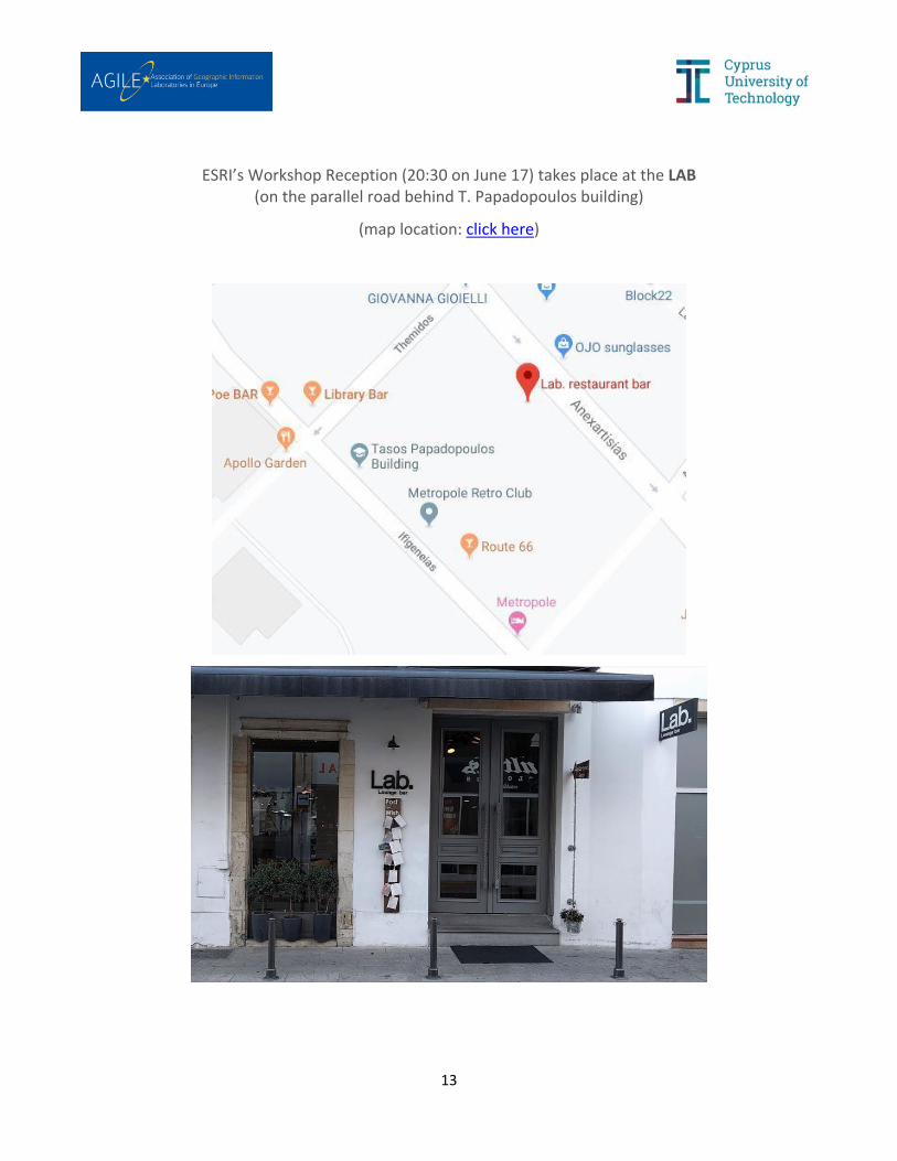
1 AGILE 2019 22 nd AGILE Conference on Geographic Information Science Geospatial Technologies for Local and Regional Development June 17-20, 2019, Limassol Cyprus Cyprus University of Technology (CUT) – Department of Civil Engineering and Geomatics Detailed Programme Final version: June 11 2019 MONDAY, JUNE 17, 2019 Workshop activities (& registration) take place at CUT’s Andreas Themistocleous Bldg. Mon 17/06 – Registrations 8:00 – 9:00 @CUT Mon 17/06 – Welcome Notes 9:00 – 9:15 @CUT Room: Pefkios Georgiades -- Andreas Themistocleous Bldg. Phaedon Kyriakidis, Dean of Faculty of Engineering and Technology, CUT Dimitrios Skarlatos, CUT (Workshop Chair) Mon 17/06 – Workshops 9:15 – 18:30 @CUT Coffee break: 11:00 – 11:30; Lunch break: 13:30 – 14:30; Coffee break: 16:00 – 16:30 Room: Keryneia / Ammochostos – Andreas Themistocleous Bldg. Reproducible Research (RR@AGILE) Daniel Nüst, Frank Ostermann, Barbara Hofer, Rusne Sileryte and Carlos Granell Room: Lemesos GeoCultGIS – Geographical and Cultural aspects of Geo-data: Issues and Solutions Tessio Novack, Yair Grinberger, Michael Schultz, Alexander Zipf and Peter Mooney Room: Computer Room R for Geovisualization, Geoprocessing and Geoanalytics Alexis Comber, Phaedon Kyriakidis and Dimitris Kavroudakis Room: Lefkosia Towards Open Spatial Data Infrastructures (half day) Bastiaan van Loenen, Ulrike Klein, Ali Mansourian and Drazen Tutic Mon 17/06 – Ice-Breaker Reception 18:30 – 20:30 @CUT’s Tassos Papadopoulos Bldg. Mon 17/06 – ESRI Workshop Reception 20:30 – 22:30 @The LAB
Transcript
1
AGILE 2019
22nd AGILE Conference on Geographic Information Science
Geospatial Technologies for Local and Regional Development
June 17-20, 2019, Limassol Cyprus
Cyprus University of Technology (CUT) – Department of Civil Engineering and Geomatics
Detailed Programme Final version: June 11 2019
MONDAY, JUNE 17, 2019
Workshop activities (& registration) take place at CUT’s Andreas Themistocleous Bldg.
Mon 17/06 – Registrations 8:00 – 9:00 @CUT
Mon 17/06 – Welcome Notes 9:00 – 9:15 @CUT
Room: Pefkios Georgiades -- Andreas Themistocleous Bldg.
Phaedon Kyriakidis, Dean of Faculty of Engineering and Technology, CUT
Diofantos Hadjimitsis, Vice-Rector for Academic Affairs, CUT Martin Raubal, AGILE Co-Chair, ETH Zurich Phaedon Kyriakidis, Dean of Faculty of Engineering and Technology, CUT
Tue-PS1-A: Geographic Information, Representation, Retrieval and Visualisation Room #6; Chair: Werner Kuhn
A context frame for interactive maps Andrea Ballatore
The impact of indoor/outdoor context on smartphone interaction during walking Jakub Krukar and Antonia van Eek
Web-based visualization of big geospatial vector data (FP) Florian Zouhar and Ivo Senner
Can Reproducible and replicable research facilitate causal explanation in Geography? Peter Kedron
3
Tue-PS1-B: Urban/Regional Modelling and Applications Room #3; Chair: Demetris Demetriou
Enhancing the use of population statistics derived from mobile phone users by considering building-use dependent purpose of stay (FP) Toshihiro Osaragi and Ryo Kudo
Evaluating walkability with WalkMyPlace - Five reasons why the utility of Walkscore.com may be limited in South America Stefan Steiniger, Carolina Rojas and Giovanni Vecchio
Study of the relationship between rental house prices and people congestion of urban areas based on mobile phone GPS data Yinglan Qin, Yuki Akiyama, Yoshiki Ogawa, Ryosuke Shibasaki and Ritsu Sakuramachi
How is multiscale accessibility related to population, functional and socio-economic characteristics of settlements: The case of Israel Nir Kaplan, David Burg and Itzhak Omer
Tue-PS1-C: Navigation, Routing and Spatial Optimisation Room #1; Chair: Ioannis Giannopoulos
Investigating geomagnetic bird navigation: 4D data fusion of co-located GPS and magnetometer data Urska Demsar
Route optimisation for winter maintenance (FP) Nikmal Raghestani and Carsten Keßler
An adaptable and scalable least cost network for air-taxis in urban areas – Study area: Manhattan, New York Moritz Hildemann and Carlos Delgado
Using GIS and open Web resources to reconstruct XuanZang travel routes and Great Tang records of the Western Regions, China Zhaohui Fu and Sheyla De Santana
Tue-PS2-A: Spatial Data Infrastructures (SDI) and Services Room #3; Chair: Ali Mansourian
Guerrilla badges for reproducible geospatial data science Daniel Nüst, Lukas Lohoff, Lasse Einfeldt, Nimrod Gavish, Marlena Götza, Shahzeib Tariq Jaswal, Salman Khalid, Laura Meierkort, Matthias Mohr, Clara Rendel and Antonia van Eek
Environmental Data Platform (EDP) – A solution to work with big data, standardized and reproducible Andrea Vianello, Armin Costa, Bartolomeo Ventura, Roberto Monsorno, Simone Tritini, Daniele Antonucci and Alexander Jacob
On-the-fly edge-matching for cascaded service content Pekka Latvala, Lassi Lehto and Samuli Kytö
A next-generation geospatial catalogue: A proof of concept Sergio Martín Segura, Francisco J Lopez-Pellicer, Juan Valiño García and F. Javier Zarazaga-Soria
Tue-PS2-B: Mobility and Transportation Room #6; Chair: Itzhak Benenson
A clustering-based framework for understanding individuals’ travel mode choice behavior (FP) Pengxiang Zhao, Dominik Bucher, Henry Martin and Martin Raubal
Classification of urban and rural routes based on motorcycle riding behaviour (FP) Gerhard Navratil, Ioannis Giannopoulos and Gilbert Kotzbek
Route choice decisions of e-bike users: Analysis of GPS tracking data in the Netherlands (FP) Gamze Dane, Tao Feng, Floor Luub and Theo Arentze
Tue-PS2-C: Geoinformation and Machine Learning Room #1; Chair: Phaedon Kyriakidis
Machine learning of spatiotemporal processes: investigating livestock changes in Mongolia with LSTM recurrent neural networks
Lex Comber, Alison Heppenstall, Taro Takahashi, Naru Tsutsumida and Paul Harris
Estimating map missing built-up areas using pre-trained Deep Neural Networks Hao Li, Benjamin Herfort and Alexander Zipf
Deep learning geodemographics with autoencoders and geographic convolution Stefano De Sabbata and Pengyuan Liu
Acquisition of urban trees using Artificial Neural Networks and remote sensing data Amelie Haas, Pierre Karrasch and Lars Bernard
5
Tue-PS2-D: Volunteered Geographic Information / Social Media Room #2; Chair: Carsten Keßler
Online data reliability for monitoring tourism activities in cities Luis Encalada, Jorge Rocha and Carlos C. Ferreira
Tracing tourism geographies with Google Trends: A Dutch case study (FP) Andrea Ballatore, Simon Scheider and Bas Spierings
Analysis of Flickr, Snapchat, and Twitter use for the modeling of visitor activity in Florida state parks Hartwig Hochmair and Levente Juhász
Introducing social distance to ST-DBSCAN Olga Yanenko
Evaluating the effectiveness of embeddings in representing the structure of geospatial ontologies (FP) Federico Dassereto, Laura Di Rocco, Giovanna Guerrini and Michela Bertolotto
Reflective practice: Lessons learnt by using board games as a design tool for Location-Based Games (FP) Catherine Jones and Konstantinos Papangelis
Wed-PS1-A: Geographic Information, Representation, Retrieval and Visualisation Room #6; Chair: Michael Gould
Potential of crowdsourced traces for detecting updates in authoritative geographic data (FP) Stefan S. Ivanovic, Ana-Maria Olteanu-Raimond, Sébastien Mustière and Thomas Devogele
Generalization of geological maps: Aggregation and typification of polygon groups Azimjon Sayidov and Robert Weibel
Determining point locations of places by using area datasets Thomas Brinkhoff
On the problem of providing unique identifiers for areas with any shape on Discrete Global Grid Systems Rubén Béjar, Miguel Ángel Latre, Francisco J Lopez-Pellicer, Javier Nogueras-Iso and F. Javier Zarazaga-Soria
Wed-PS1-B: Urban/Regional Modelling and Applications Room #3; Chair: Alexis Comber
Residential interrelationship: The case study of the Sylheti and Dhaka communities of Whitechapel Flint Shlomit
A scalable analytical framework for spatio-temporal analysis of neighborhood change: A sequence analysis approach (FP) Nikos Patias, Francisco Row and Stefano Cavazzi
Estimating the spatial distribution of vacant houses using public municipal data (FP) Yuki Akiyama, Akihiro Ueda, Kenta Ouchi, Natsuki Ito, Yoshiya Ono, Hideo Takaoka and Kohta Hisadomi
7
Wed-PS1-C: Earth Observation Applications Room #1; Chair: Peter Atkinson
Monitoring urbanization dynamics in Cyprus using time-series DMSP/OLS Nightlight Imagery Stylianos Hadjipetrou and Demetris Stathakis
Random forest classification analysis of Sentinel-2 and Landsat-8 images over semi-arid environment in the Eastern Mediterranean Stavros Patsalidis, Athos Agapiou and Diofantos G. Hadjimitsis
Utilization of Tandem-X data to identify the potential trigger of the 2018’s Sunda Strait Tsunami in Indonesia Winhard Tampubolon and Wolfgang Reinhardt
Training samples from open data for satellite imagery classification: Using K-means clustering Cláudia M. Viana, Inês Girão and Jorge Rocha
Wed-PS2-A: Spatial Data Infrastructures (SDI) and Services Room #6; Chair: Chris Danezis
Civil Protection 2.0: A diagram-based approach for managing an emergency plan Monica Sebillo, Giuliana Vitiello, Michele Risi, Michele Grimaldi and Dimitri Dello Buono
Interoperable management of glider sensor data Matthes Rieke, Simon Jirka, Daniel Hayes, Justin H. Buck and Ehsan Abdi
An event-driven architecture based on Copernicus satellite data for water monitoring Sebastian Drost, Matthes Rieke, Simon Jirka, Arne Vogt, Verena Rabea Kirstein and Andreas Wytzisk
The TN-ITS platform: Creating a seamless data-exchange on changes in critical road network related spatial data between road authorities and map providers in Cyprus Georgios Christou, Andreas Georgiou, Christos Panayiotou and Aristotelis Savva
Wed-PS2-B: Mobility and Transportation Room #3; Chair: Urska Demsar
Implications of incomplete GPS-enabled mobile phone data on human mobility studies Enki Yoo, John Roberts and Youngseob Eum
Identification of the homes, offices, and schools from long-interval mobile phone big data using mobility pattern clustering Ryosuke Kobayashi, Satoshi Miyazawa, Yuki Akiyama and Ryosuke Shibasaki
Development of people flow data with individual demographics based on mobile phone GPS Big Data Yohshiki Ogawa, Yuki Akiyama and Ryosuke Shibasaki
Classification of street junctions according to traffic regulators Stefania Zourlidou, Colin Fischer and Monika Sester
8
Wed-PS2-C: Environmental Modelling and Applications Room #1; Chair: Lars Bernard
The relationship between land surface temperature and local climate zone classification: A case study of the canton Geneva, Switzerland Maryam Lotfian, Jens Ingensand, Sarah Composto, Monia Elisa Molinari and Maria Antonia Brovelli
Improving business-as-usual scenarios in land change modelling by extending the calibration period and integrating demographic data (FP) Romain Mejean, Martin Paegelow, Mehdi Saqalli and Doryan Kaced
Geostatistical analysis of temperature in the boundary layer using variogram scaling exponents Amy Frazier and Benjamin Hemingway
Flood risk assessment and mitigation using small unmanned aircraft data Jordan Bates and Tanmoy Chakraborty
Wed-PS2-D: Earth Observation, Terrain Modeling and Applications Room #2; Chair: Marek Baranowski
Creating visually consistent DEMs over water bodies using laser scanning data Ville Mäkinen, Juha Oksanen and Tapani Sarjakoski
InSAR DSM using Sentinel 1 and spatial data creation Vasileios Letsios, Ioannis Faraslis and Demetris Stathakis
Sampling designs for selecting points from digital surface models to create digital terrain models Philip Fayad, Apostolos Papakonstantinou and Phaedon Kyriakidis
A GIS-based approach to karst relief cyclicity by using Fast Fourier Transform Tomaž Podobnikar, Mateja Štefančič and Timotej Verbovšek
Wed-PS3-A: Geospatial Technologies Workforce Room #6; Chair: Carlos Granell Canut
Understanding skill needs in the EO/GI sector: a job advertisements analysis Wesley Gruijthuijsen, Saudade Pontes, Glenn Vancauwenberghe, Danny Vandenbroucke and Marc Olijslagers
Future occupational profiles in Earth Observation / Geoinformation – Scenarios Resulting from Changing Workflows (FP) Barbara Hofer, Stefan Lang and Nicole Ferber
Wed-PS3-B: Urban/Regional Modelling and Applications Room #3; Chair: Marco Painho
Exploring social dynamics: predictive geodemographics Jennie Gray, Lisa Buckner and Alexis Comber
Predicting short-term travel demand in bike sharing systems with neural networks Yuanxuan Yang, Alison Heppenstall, Andy Turner and Alexis Comber
Market area delineation for airports to predict the spread of infectious disease (FP) Carmen Huber and Claus Rinner
Keynote Presentation: The organization of spatial memory: multiple systems of representation?
Marios Avraamides
Thu 20/06 – Best Short Paper Nominations 10:00 – 11:15 @CUT – Amph#1
Chair: Martin Raubal
Geographical context in community detection: A comparison of a node-based and a link-based approach Sebastijan Sekulić, Jed Long and Urska Demsar
Quantifying how visibility-based land cover and wilderness measures relate to perceived scenicness of landscape Yi-Min Chang Chien, Alexis Comber and Steve Carver
Coffee Break @CUT 11:15 – 11:45
10
Thu 20/06 – Best Full Paper Nominations 11:45 – 13:30 @CUT – Amph#1
Chair: Marinos Kavouras
Towards a usability scale for participatory GIS Andrea Ballatore, Will McClintock, Grace Goldberg and Werner Kuhn
Place questions and human-generated answers: A data analysis approach Ehsan Hamzei, Haonan Li, Maria Vasardani, Timothy Baldwin, Stephan Winter and Martin Tomko
Relaxing unanswerable geographic questions using a spatially explicit knowledge graph embedding model Gengchen Mai, Bo Yan, Krzysztof Janowicz and Rui Zhu
Tassos Papadopoulos Bldg.; Amphitheatre #2; Chair: Barbara Hofer
Reproducible publications at AGILE conferences – Proposed guidelines for authors and reviewers Barbara Hofer, Karl W. Broman, Carlos Granell, Anita Graser, Kristina Hettne, Daniel Nüst, Frank Ostermann, Rusne Sileryte, Marta Teperek
GIS-analysis of the technical potential of wind energy in the Netherlands Sebastiaan van Bemmel and Bart Rijken
Combining network methods with longitudinal data analysis to examine spatio-temporal variation in bike sharing data Sarah Gadd, Alison Heppenstall, Mark S Gilthorpe and Peter Tennant
A GIS-based spatial multi-criteria decision analysis: Crisp and fuzzy methods Chrysaida-Aliki Papadopoulou and Thomas Hatzichristos
MARRE: A research project to monitor the Hellenic Seas using remote sensing Konstantinos Topouzelis, Elena Athanasopoulou, Andromachi Chatziantoniou, Athanasia Iona, Aristomenis Karageorgis, Dimitris Kavroudakis, Pantelis Mitropoulos, Apostolos Papakonstantinou, Stella Psarra, Spyros Spondylidis, Panagiotis Symeonidis and Theodoros Vakkas
Regional agricultural production statistics for 160 years using the geographic information system and the spatial analytical technique Cláudia M. Viana, Dulce Freire and Jorge Rocha
Model of research of sociodemographic structures Donatas Gudelis
Identify the backbone structure of highway network System for Chinese 23 urban regions Huiping Liu, Xiangping Liu and Lifu Zheng
11
From question to query: GIS for impact assessment Rusne Sileryte, Alexander Wandl, Jorge Gil and Arjan van Timmeren Map generalization based on a superpixel structure Yilang Shen and Tinghua Ai
Development of the TATM metadata editor for the documentation of spatial data from the Hellenic area according to INSPIRE directive Dimitrios Sarafidis, Faidon Zampoglou and Maria Papadopoulou
Similarity of paths in spatial networks: The case of long-distance athletic events Dimitris Kavroudakis, Panagiotis Agourogiannis, Marios Batsaris, Michalis Vaitis, Efstratios Kavroudakis and Panayiotis Kouloumentas
A spatial optimization approach for vector-based land use planning Jing Yao and Xiaoxiang Zhang
Semantic enrichment of routing engines using linked data: A case study using GraphHopper Junaid Abdul Jabbar and Rizwan Bulbul
A spatiotemporal approach for detecting street intersections Stefania Zourlidou, Maximilian Idahl and Monika Sester
Mapping ice cover dynamics in the Curonian Lagoon using remote sensing and geographic information system Rasa Idzelytė, Igor Kozlov and Georg Umgiesser An information system for the detection of water leaks in municipal water networks Poulicos Prastacos, Manolis Diamandakis and Manolis Kosmadakis Evaluation of natural flood management using curve number in the Ciliwung Basin, West Java Arif Rohman, Lex Comber and Gordon Mitchell
Cloud based discovery and processing of geospatial data Arne Vogt, Andreas Wytzisk, Sebastian Drost and Simon Jirka
Metadata assessment for efficient open data retrieval Chiao-Ling Kuo and Han-Chuan Chou
Using weather condition and advanced machine learning methods to predict soccer outcome Denny Asarias Palinggi, Francisco Ramos, Joaquín Torres-Sospedra and Sergi Trilles
Feature extraction in parallel with georeferencing for the digitalization of historical maps Tyng-Ruey Chuang, Chiao-Ling Kuo, Jheng-Hong Lai, Hsiung-Ming Liao and Huang-Sin Syu
A monocular SLAM method for point cloud geolocation in GPS-denied environments using UASs Dimitrios Trigkakis, Dimitris Chatziparaschis, George Petrakis, Achilles Tripolitsiotis and Panagiotis Partsinevelos
Integrated use of machine learning and geostatistics for high resolution mapping of ground-level PM2.5 concentrations Guofeng Cao and Ying Liu
Google map locations of AGILE 2019 premises follow on the next page
12
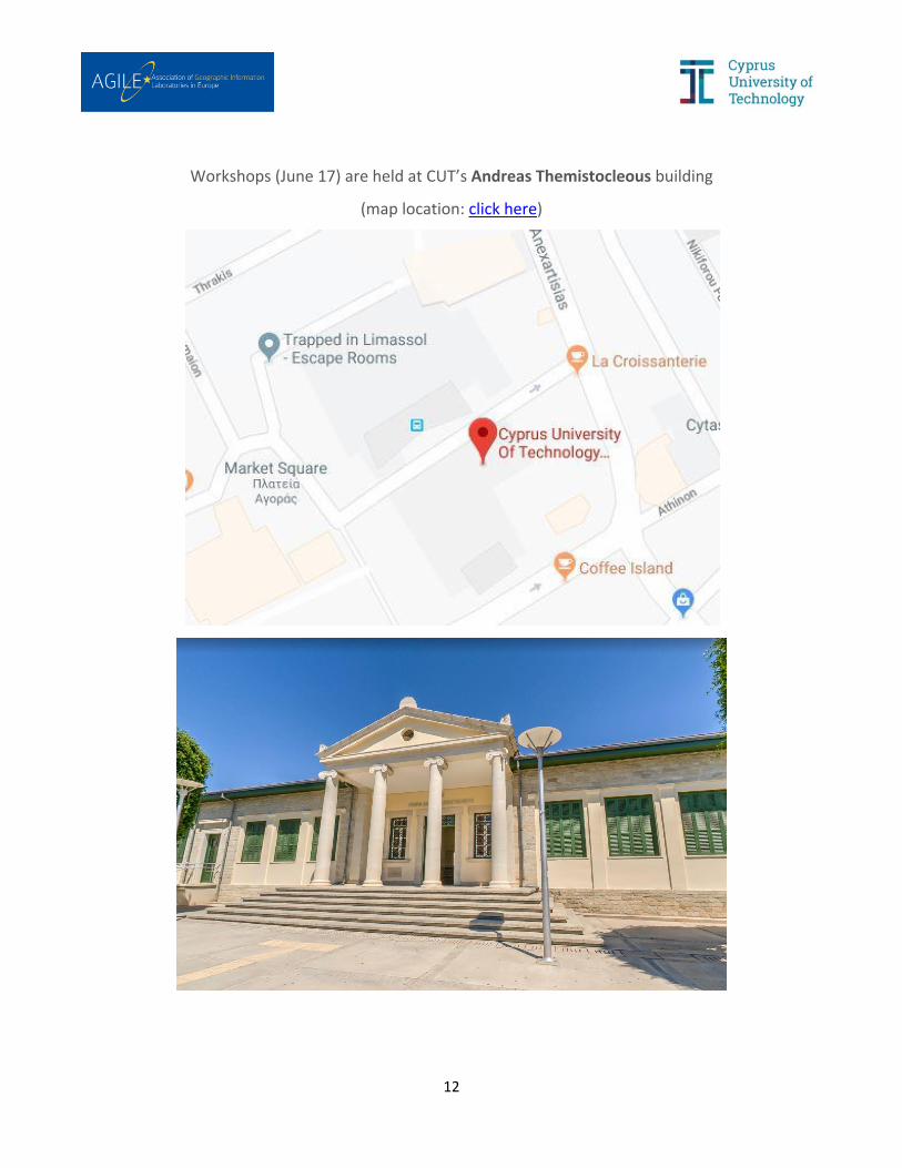
Workshops (June 17) are held at CUT’s Andreas Themistocleous building
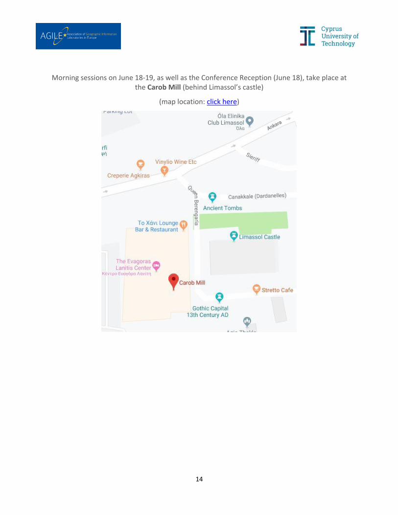
Ice-Breaker Reception (June 17), all afternoon parallel sessions (June 18-19), as well as all sessions on June 20, take place at CUT’s Tassos Papadopoulos building