8
Agisoft PhotoScan Processing Report 04 August 2017
| Date post: | 02-Jul-2018 |
| Category: |
Documents |
| Upload: | truongnhan |
| View: | 213 times |
| Download: | 0 times |

Agisoft PhotoScanProcessing Report
04 August 2017

Survey Data
50 m
1
2
3
4
5
6
7
8
9
> 9
Fig. 1. Camera locations and image overlap.
Number of images: 1,769
Flying altitude: 20.3 m
Ground resolution: 7.78 mm/pix
Coverage area: 0.0823 km²
Camera stations: 1,769
Tie points: 571,591
Projections: 2,931,420
Reprojection error: 1.76 pix
Camera Model Resolution Focal Length Pixel Size Precalibrated
FC300X (3.61 mm) 4000 x 3000 3.61 mm 1.56 x 1.56 μm No
Table 1. Cameras.

Camera Calibration
1 pix
Fig. 2. Image residuals for FC300X (3.61 mm).
FC300X (3.61 mm)
1769 images
Type Resolution Focal Length Pixel SizeFrame 4000 x 3000 3.61 mm 1.56 x 1.56 μm
Value Error F Cx Cy B1 B2 K1 K2 K3 K4 P1 P2
F 2263.65 0.44 1.00 -0.72 -0.94 -0.04 -0.12 -0.01 -0.14 0.29 -0.36 -0.05 0.05
Cx 3.0735 0.035 1.00 0.68 0.04 0.14 -0.01 0.12 -0.22 0.27 0.29 -0.04
Cy 41.0749 0.064 1.00 0.00 0.12 -0.01 0.15 -0.29 0.35 0.05 0.05
B1 -10.6814 0.011 1.00 0.01 0.01 -0.01 0.01 -0.00 0.00 -0.02
B2 0.767534 0.012 1.00 -0.00 0.02 -0.04 0.05 0.01 -0.01
K1 0.00160911 4.8e-05 1.00 -0.96 0.89 -0.82 -0.01 -0.01
K2 -0.0345384 0.00016 1.00 -0.98 0.94 0.01 -0.00
K3 0.0590483 0.00022 1.00 -0.99 -0.02 0.01
K4 -0.024278 0.0001 1.00 0.02 -0.01
P1 -0.000152054 1.7e-06 1.00 0.01
P2 0.000643677 1.3e-06 1.00
Table 2. Calibration coefficients and correlation matrix.
Camera Locations
50 m
-90 m
-72 m
-54 m
-36 m
-18 m
0 m
18 m
36 m
54 m
72 m
90 m
x 1
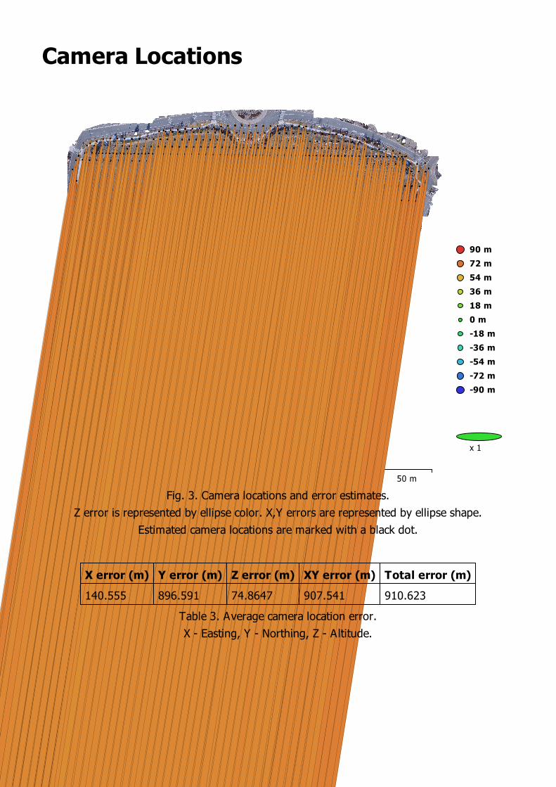
Fig. 3. Camera locations and error estimates.
Z error is represented by ellipse color. X,Y errors are represented by ellipse shape.
Estimated camera locations are marked with a black dot.
X error (m) Y error (m) Z error (m) XY error (m) Total error (m)
140.555 896.591 74.8647 907.541 910.623
Table 3. Average camera location error.
X - Easting, Y - Northing, Z - Altitude.

Ground Control Points
50 m
D1
D2
D3
D4
D5D6
D7
D8
D9
Control points Check points
-2.5 cm
-2 cm
-1.5 cm
-1 cm
-0.5 cm
0 cm
0.5 cm
1 cm
1.5 cm
2 cm
2.5 cm
x 300
Fig. 4. GCP locations and error estimates.
Z error is represented by ellipse color. X,Y errors are represented by ellipse shape.
Estimated GCP locations are marked with a dot or crossing.
Count X error (cm) Y error (cm) Z error (cm) XY error (cm) Total (cm)
9 1.23773 1.91448 1.57255 2.27974 2.7695
Table 4. Control points RMSE.
X - Easting, Y - Northing, Z - Altitude.

Label X error (cm) Y error (cm) Z error (cm) Total (cm) Image (pix)
D1 -0.124677 -3.70271 2.1619 4.28946 0.132 (12)
D2 1.96643 -1.93454 0.378182 2.78429 0.252 (12)
D3 1.80673 0.897913 -1.21429 2.35479 0.240 (16)
D4 0.653703 1.45573 -0.526376 1.68035 0.144 (18)
D5 -0.46697 1.18036 2.08291 2.43923 0.155 (15)
D6 -0.623182 0.929906 1.31372 1.72596 0.139 (22)
D7 -2.24129 0.497824 -2.29844 3.2487 0.184 (13)
D8 -0.72274 -1.88642 0.174984 2.0277 0.089 (12)
D9 -0.248113 2.55827 -2.07606 3.30399 0.166 (13)
Total 1.23773 1.91448 1.57255 2.7695 0.172
Table 5. Control points.
X - Easting, Y - Northing, Z - Altitude.

Digital Elevation Model
50 m
1.36 km
1.37 km
Fig. 5. Reconstructed digital elevation model.
Resolution: 3.11 cm/pix
Point density: 10.3 points/cm²

Processing Parameters
General
Cameras 1769
Aligned cameras 1769
Markers 9
Coordinate system NAD83(HARN) / Nevada West (ftUS) (EPSG::3431)
Rotation angles Yaw, Pitch, Roll
Point Cloud
Points 571,591 of 697,926
RMS reprojection error 0.212355 (1.7635 pix)
Max reprojection error 1.37912 (42.1543 pix)
Mean key point size 7.49583 pix
Effective overlap 5.47786
Alignment parameters
Accuracy Medium
Generic preselection Yes
Reference preselection Yes
Key point limit 20,000
Tie point limit 2,000
Constrain features by mask No
Adaptive camera model fitt ing Yes
Matching time 1 hours 3 minutes
Alignment time 44 minutes 47 seconds
Optimization parameters
Parameters f, b1, b2, cx, cy, k1-k4, p1, p2
Fit rolling shutter No
Optimization time 4 minutes 50 seconds
Dense Point Cloud
Points 107,217,455
Reconstruction parameters
Quality Medium
Depth filtering Aggressive
Depth maps generation time 5 hours 8 minutes
Dense cloud generation time 59 minutes 31 seconds
DEM
Size 16,053 x 15,077
Coordinate system NAD83(HARN) / Nevada West (ftUS) (EPSG::3431)
Reconstruction parameters
Source data Dense cloud
Interpolation Enabled
Processing time 5 minutes 56 seconds
Software
Version 1.3.2 build 4205
Platform Windows 64


![KM C308-20180327114032doctorate.uab.ro/upload/64_1885_cv_ionescu_petru.pdf · Dictionar terminologic explicativ. Bazã de date, 12 cm [1 cm=100p], Cluj-Napoca, Argonaut, 2005. ISBN](https://static.documents.pub/doc/80x56/5e2d7ff4ae3f3e53000fa989/km-c308-201-dictionar-terminologic-explicativ-baz-de-date-12-cm-1-cm100p.jpg)


