246
Al Buraimi Integrated Urban Development: A strategic approach towards resilience

Al Buraimi Integrated Urban Development:
A strategic approach towards resilience
2
All rights reserved:
Technische Universität Berlin
Urban Management Program
Editors:
Sonja Nebel
Jesús Salcedo V.
Authors:
Jesús Salcedo V.
Pedro Becerra
Panagiotis Achamnos
Florencia Carvajal
Ana Alcántara
Sonja Nebel
Proofreading:
Shane O’Hanlon
Website: www.urbanmanagement.tu-berlin.de
© Al Buraimi, A Strategic Approach towards Integrated Urban Development and Resilient Urban
Management
Layout by Jesus Salcedo V www.js-arquitectos.com

3
Al Buraimi Integrated Urban Development: A strategic approach towards resilience
Al Buraimi Integrated Urban Development:A strategic approach towards resilience
Berlin, 2015
Technische Universität BerlinUrban Management Program

4
Foreword
The aspirations of communities evolve and change with the requirements and development of
societies. Cities and towns are beautiful places that contribute to the variety of cultures and to
the quality of life of communities in our diverse world. The Buraimi governorate with a history of
intra-regional trade and a meeting ground of trading convoys was indicated as part of Twam, and
the well known Al Buraimi oasis. Out of a desire for further development in the cities of Al Buraimi
governorate, research institutions from Oman and abroad have been involved. The cooperation
between the Municipal Council in Al Buraimi Governorate and the Technical University of Berlin
brings in the Urban Management Master Program to evaluate the current situation and policies in
the sectors covered by the studies of the program.
It is our goal that such cooperation serves as a model for further efforts with academic and research
institutions of urban planning. The results of this cooperation will contribute in the formation of
better government for the civil society and to enriching the knowledge about urban planning, public
transport, tourism and architecture.

5
Al Buraimi Integrated Urban Development: A strategic approach towards resilience
Advancing the municipal sector in the cities of the world towards innovation, it is important to
localize innovative thoughts within authorities of planning and executive bodies and activate the role
of private sector as well as to encourage creative locals to play an active role in the formation of the
civil character of modern cities. Such an approach will significantly contribute to the development,
the culture and economy of the Sultanate of Oman.
On behalf of the people of Al Buraimi Governorate, myself and all municipal council and government
institutions’ staff, I extend our thanks to the Technical University of Berlin - Urban Management
Program- and all Master students that participated in the studies and co-operation with the
municipal council in the governorate. We appreciate the efforts that they have made for the success
of the co-operation and we are looking forward to further co-operations in the future. Our thanks go
to all my fellow members of the municipal council on their active role.
Ibrahim Said Al Busaidi
Governor of Al Buraimi
Chairman of Al Buraimi Municipal Council

6
Foreword
This report is intended to open a broader discourse on future development in the Governorate
of Al Buraimi, Sultanate of Oman. The country is facing high population growth and a dynamic
urbanization process that has been started about 45 years ago based on the discovery of fossil fuels.
Not only in the capital city of Muscat but as well in smaller towns and former rural areas drastic
transformation took place – and is still ongoing. An increasing need for jobs, social and health
facilities, transport infrastructure as well as for housing is confronted with limited resources such as
oil and gas but as well land and environment.
The Governorate and Municipality of Al Buraimi have started to assess and reflect ongoing processes
and invited five young architects and civil engeneers, students from the Urban Management Master
Programme of TU Berlin, Germany to research on key fields of urban and regional development in
the Governorate.
Five key fields have been selected according to emerging challenges in the Governorate, such as
how to handle the threatening decay of the historic parts of the former oasis Hamasa and Sa’ara,
how to meet the high demand for residential plots, how to get them serviced properly and in time
with fresh water, electricity and sewage systems, how to allow for appropriate transport and mobility
within the city and how to balance expanding urban structures with remaining rural ones in the
region with its particular constraints and potentials.
This report describes the current state of development in the forementioned fields and presents
recommendations towards a comprehensive strategic urban management in Al Buraimi, based
on the overall goal of a sustainable and resilient future development to be managed within cross-
sector coordination and interdepartemental cooperation. This is summarized in short-, medium-
,and longterm action plans accompanied by a chapter on further studies needed, on capacity
development and on cross cutting issues related to all five key fileds worked on.

7
Al Buraimi Integrated Urban Development: A strategic approach towards resilience
We hope to offer forwordlooking and encouraging findings that may foster a vivid dialogue - among
all parties involved- about crucial issues of Al Buraimi future development. This report could
have been elaborated thanks to the highly appreciated support –financial as well as technical and
organizational- from the Governorate and the Municipality of Al Buraimi. The joint efforts taken from
Al Buraimi Governmental Organizations and TU Berlin, Urban Management Programme made
it possible to conduct a field survey in September/October 2014 followed by intensive scientific
elaborations in form of master thesis submitted in February 2015.
We wish to express our sincere gratitude for the opportunity to carry out this report in fruitful
cooperation between Al Buraimi Governorate and Municipality and TU Berlin
Dr. Sonja Nebel / Dr. Bettina Hamann
Urban Management Program

8
Acknowledgments
The team is most grateful to the Governorate of Al Buraimi, and to the Municipal Council for the
opportunity to do research and field work, besides the generous financial support that made this
possible.
This research would not have been possible without the help and interest of His Excellency Al Sayed
Ibrahim Bin Said Al Busaidi, Governor of Al Buraimi.
The team would also like to thank the following Ministry Branches in Al Buraimi for their kindness
and welcoming during all the interviews: Al Buraimi Governorate Office, Ministry of Agriculture
and Fisheries Al Buraimi Branch, Ministry of Environment & Climate Affairs Al Buraimi Branch,
Ministry of Housing Al Buraimi Branch, Ministry of Regional Municipalities & Water Resources Al
Buraimi Branch, Ministry of Tourism Al Buraimi Branch, Ministry of Transport and Communications
Al Buraimi Branch, Ministry of Transport and Communications in Muscat, Municipal Council of Al
Buraimi, Oman Chamber of Commerce & Industry Al Buraimi Branch, and the Transit Department
of the Royal Oman Police of Al Buraimi.
Many thanks to Dr. Hammad Al Gharibi for his initiative, guidance and welcoming in Al Buraimi.
Likewise, thanks to the members of the Municipal Council of Al Buraimi for fostering this research.
Special thanks to Mohammed Al-Badi, Sheikha Al Naimi and Mohammed bin Hamed bin Miftah Al
Shamsi.
Sinicerely,
Panagiotis Achamnos, Ana Alcántara, Pedro Becerra, Florencia
Carvajal, Bettina Hamann, Sonja Nebel, Jesús Salcedo
9
Al Buraimi Integrated Urban Development: A strategic approach towards resilience
Table of contentsForeword ........................................................................................................................................................................ 6
Acknowledgments ......................................................................................................................................................8
List of figures ....................................................................................................................................................................... 12
List of boxes .......................................................................................................................................................................16
List of abbreviations and acronyms ................................................................................................................................. 18
Executive Summary ................................................................................................................................................... 20
Part 1 Current trends and challengesIntroduction ...................................................................................................................................................................... 24
Rationale .......................................................................................................................................................................27
Urbanization background in Oman and Al Buraimi ..............................................................................................................28
History and urbanization in inner Oman settlements ...........................................................................................34
History and urbanization in Al Buraimi .................................................................................................................................36
Current trends .......................................................................................................................................................................41
Current challenges ................................................................................................................................................... 44
SWOT analysis ...................................................................................................................................................................... 46
Al Buraimi 2030; a vision for a resilient future ..............................................................................................................52
The need for a paradigm shift .................................................................................................................................54
Part 2.1 Regional development & growth managementAssesment of the current state .................................................................................................................................58
Spatial analysis ...................................................................................................................................................................... 64
The setting of areas for strategic development and growth management ....................................................................... 68
The city centre of Al Buraimi ....................................................................................................................................................72
The outskirts of Al Buraimi: ....................................................................................................................................................76
As Sunainah ...................................................................................................................................................................... 80
Selected instruments for urban growth management ...........................................................................................82
Action plan for regional development through growth management ....................................................................... 86
Conclusions ...................................................................................................................................................................... 89
References ......................................................................................................................................................................90

10
Part 2.2 Sustainable transportationAssessment of the current state of transportation and mobility .......................................................................................... 96
Transportation planning procedure ............................................................................................................................... 101
Transportation legal framework ...............................................................................................................................102
Urban space for mobility ..................................................................................................................................................104
Goals ... .....................................................................................................................................................................................107
Governance / Institutional recommendations ............................................................................................................108
Technical recommendations .................................................................................................................................................. 114
Improvement of regional public transportation ............................................................................................................120
Action / management plan .................................................................................................................................................. 121
Conclusions ..................................................................................................................................................................... 122
References ..................................................................................................................................................................... 123
Part 2.3 Infrastructure DevelopmentAssesment of the current state of infrastructure ............................................................................................................ 128
Water management .................................................................................................................................................. 134
Strategies for sustainable development in water management ......................................................................................... 138
Solid waste management .................................................................................................................................................. 141
Strategies for sustainable development in solid waste management ...................................................................... 143
Wastewater management .................................................................................................................................................. 147
Strategies for sustainable development in wastewater management ...................................................................... 150
Conclusions ..................................................................................................................................................................... 152
References ......................................................................................................................................................................155
Part 2.4 Housing & urban designAssessment of the current state of housing ............................................................................................................162
Urban planning instruments – structure plans compared .........................................................................................164
Finding: Dual reality – dual dynamics of develoment .........................................................................................170
Finding: Change in urban morphology ...............................................................................................................................176
Recommendations .................................................................................................................................................. 182
Guidelines for urban design .................................................................................................................................................. 183
References ..................................................................................................................................................................... 185

11
Al Buraimi Integrated Urban Development: A strategic approach towards resilience
Part 2.5 Heritage management and responsible tourismAssesment of the current state of heritage ........................................................................................................... 190
Tourism in Al Buraimi .................................................................................................................................................. 191
Heritage assets inventory for tourism in Al Buraimi ............................................................................................................ 195
Hamasa: an example for responsible tourism development .........................................................................................201
Guidelines and Action plan towards responsible tourism in Hamasa ..................................................................... 203
Conclusions ..................................................................................................................................................................... 211
References .....................................................................................................................................................................212
Part 3 Further recommendationsCross cutting issues ..................................................................................................................................................216
Capacity Development for sustainable development Al Buraimi ......................................................................221
Further Studies recommended ...............................................................................................................................225
Conclusions .................................................................................................................................................................... 229
AnnexMethodological remarks ..................................................................................................................................................232
List of Institutions visited .................................................................................................................................................. 233
Glossary ....................................................................................................................................................................................234
Most relevant references ..................................................................................................................................................237
About the authors ................................................................................................................................................. 242

12
Figure 1. Main suq in Al Buraimi .......................................................................................25
Figure 2. Abandoned agricultural plots in the city centre ........................................ 26
Figure 3. Geographical location of Oman. ...................................................................... 29
Figure 4. Hajar mountain range, Oman. .......................................................................32
Figure 5. Urbanization process of an inner Oman oasis settlement: Nizwa ........... 33
Figure 6. Geographical location of Al Buraimi Governorate ......................................... 35
Figure 7. Villages in the Buraimi Oasis area. .......................................................................36
Figure 8. View of an aflaj channel ....................................................................................... 37
Figure 9. Current state of As Sara, ...................................................................................... 40
Figure 10. Lost oasis and heritage .......................................................................................43
Figure 11. A street in Sa ‘ara, Al Buraimi .......................................................................43
Figure 12. View of the scattered neighbourhoods ........................................................ 55
Figure 13. Maximum and minimum temperatures in Al Buraimi Governorate. ...........58
Figure 14. Average rainfall in Al Buraimi Governorate ........................................................59
Figure 15. Production of desalinated water in different Governorates. ..........................61
Figure 16. Omani population pyramid in Al Buraimi Governorate in 2012 ......................... 62
Figure 17. Expat population pyramid in Al Buraimi Governorate in 2012 ......................... 62
Figure 18. Mens tailoring and readymade clothes. ....................................................... 64
Figure 19. Spatial charachetristics in Al Buraimi ........................................................65
Figure 20. Satelite view of Al Buraimi’s .......................................................................67
Figure 21. Current land use plan .......................................................................................67
Figure 22. Strategic area 1. City centre and 2. Outskirts. ....................................................... 69
Figure 23. Strategic area 2. As Sunainah ...................................................................... 70
Figure 24. Strategic area 1. City centre satelite image ........................................................72
Figure 25. Strategic area 1. City centre: Urban growth management instruments ........... 73
List of figures

13
Al Buraimi Integrated Urban Development: A strategic approach towards resilience
Figure 26. Strategic area 1. City centre: Specialized clothing cluster ..........................74
Figure 27. Strategic area 1. City centre: Time allowed for plots to develop .......................... 75
Figure 28. Strategic area 1. City centre: Urban design intervention potential ........... 75
Figure 29. Strategic area 2. Outskirts satelite image: ........................................................76
Figure 30. Strategic area 2. Outskirts: Urban growth management instruments ...........77
Figure 31. Strategic area 2. Outskirts: New typology implementation ..........................78
Figure 32. Strategic area 2. Outskirts: Urban design intervention potential: ...........78
Figure 33. Scattered housing in the outskirts of Al Buraimi .........................................79
Figure 34. Strategic area 3. As Sunainah: satelite image ....................................................... 80
Figure 35. Strategic area 3. As Sunainah: urban growth management instruments ...........81
Figure 36. Action plan for growth management ........................................................87
Figure 37. View of Al Buraimi‘s scattered urbanism ....................................................... 89
Figure 38. Built roads in Al Buraimi ...................................................................................... 98
Figure 39. Carbon dioxide emissions in Oman ...................................................................... 98
Figure 40. Mobility creating factors .................................................................................... 100
Figure 41. Transportation planning procedure .....................................................................102
Figure 42. Sample area in Al Buraimi ..................................................................................... 105
Figure 43. Map of roads network in Al Buraimi .................................................................... 106
Figure 44. New road in Al Buraimi ..................................................................................... 112
Figure 45. Public transportation plan ..................................................................................... 116
Figure 46. Transit oriented development TOD concept ...................................................... 118
Figure 47. Activity centers .................................................................................................... 119
Figure 48. Action management plan ..................................................................................... 121
Figure 49. Technical recommendations ..................................................................... 121
Figure 50. Roundabout sign .................................................................................................... 122
14
Figure 51. Thaqbah well .................................................................................................... 133
Figure 52. Production from wells, ..................................................................................... 133
Figure 53. Total water distribution in Al Buraimi ...................................................... 137
Figure 54. Water saving campaign adds ..................................................................... 139
Figure 55. Landfill ................................................................................................................... 143
Figure 56. School children educated in recycling programmes ....................................... 145
Figure 57. Treatment plant ....................................................................................................149
Figure 58. Action plan 1984 ....................................................................................................164
Figure 59. Structure plan 1985 ..................................................................................... 165
Figure 60. Expansion plan 1986-1996 .....................................................................................166
Figure 61. Expansion plan 1987-1990 .....................................................................................167
Figure 62. Road hierarchy and town access according to structural plan ........................168
Figure 63. Current Al Buraimi map used for planning ......................................................169
Figure 64. Constructed Al Buraimi .....................................................................................170
Figure 65. Marked plots .....................................................................................................171
Figure 66. Planned vs granted plots ......................................................................................171
Figure 67. Omani and expat population in Al Buraimi Governorate ........................ 172
Figure 68. Chronological division scheme ..................................................................... 173
Figure 69. Expat on his way home ..................................................................................... 174
Figure 70. Preffered living areas .....................................................................................176
Figure 71. Neighbourhoods in the outskirts ..................................................................... 177
Figure 72. Neighbourhoods in the city centre ..................................................................... 177
Figure 73. Neighbourhoods in the city centre 2 ...................................................... 177
Figure 74. Built structure change ..................................................................................... 178
Figure 75. Public space alteration .....................................................................................179
Figure 76. Article 58 a)1 .................................................................................................... 181

15
Al Buraimi Integrated Urban Development: A strategic approach towards resilience
Figure 77. Article 58 a)2 .................................................................................................... 181
Figure 78. Recommendations. ..................................................................................... 183
Figure 79. Location of heritage sites ..................................................................................... 195
Figure 80. Decay situation in Sa´ara. .....................................................................................196
Figure 81. Decay situation in Hamasa .....................................................................196
Figure 82. Al Khandaq fort ....................................................................................................197
Figure 83. Pottery in Nizwa ....................................................................................................199
Figure 84. Basketry in Al Buraimi .....................................................................................199
Figure 85. Dry falaj in Sa´ara. ....................................................................................200
Figure 86. Interventions in Phase I .....................................................................................205
Figure 87. Interventions in Phase II .................................................................................... 207
Figure 88. Night tour walking route .................................................................................... 207
Figure 89. Interventions in Phase III, ....................................................................................209
Figure 90. Summary of the action plan ....................................................................209
Figure 91. National Fort Route .....................................................................................210
Figure 92. Ruins in Hamasa .................................................................................................... 211
Figure 93. Capacity development process .....................................................................222
Figure 94. Three levels of capacity development ......................................................222
Figure 95. Interrelation of levels in capacity development .......................................223
Figure 96. Agriculture in As Sunainah .................................................................................... 229

16
Box 1. Living conditions are changing rapidly ....................................................................... 18
Box 2. Aim of the study .................................................................................................................... 20
Box 3. Unique geographical characteristics amongst the Arabian Peninsula ..........................27
Box 4. Particularities in inner country settlements. ...................................................................... 29
Box 5. Diverse nature of challenges .......................................................................................38
Box 6. Land availability .....................................................................................................................39
Box 7. Strengths .....................................................................................................................41
Box 8. Weaknesses .................................................................................................................... 42
Box 9. Opportunities .....................................................................................................................43
Box 10. Threats ....................................................................................................................................45
Box 11. Rising problematic ..................................................................................................... 48
Box 12. Basic considerations for the instruments .......................................................................65
Box 13. Parking ratio test .................................................................................................................... 99
Box 14. Land allocation ................................................................................................................... 123
Box 15. Community survey on fresh water ..................................................................................... 134
Box 16. Community survey on solid waste management ...................................................... 138
Box 17. Community survey on wastewater management ...................................................... 147
Box 18. Additional population ................................................................................................... 160
Box 19. Social aspects of housing ....................................................................................................164
Box 20. Responsible and sustainable tourism ..................................................................... 187
Box 21. UNESCO World Heritage ....................................................................................................189
Box 22. People perceptions about Al Buraimi’s attractiveness ..................................................... 190
Box 23. Tangible assets criteria .................................................................................................... 191
Box 24. The Buraimi Oasis .................................................................................................... 193
List of boxes

17
Al Buraimi Integrated Urban Development: A strategic approach towards resilience
Box 25. Intangible assets: criteria ....................................................................................................194
Box 26. Further tangible assets examples: Falaj irrigation system .......................................196
Box 27. Tools for participation .................................................................................. 213
18
List of abbreviations and acronyms
AD Anno Domini, after Christ
APFO Adequate Public Facility Ordinance
BC Before Christ
B&B Bed & Breakfast
CDS City Development Strategy
COC Chamber of Commerce
Expats Expatriate
FYP Five-Year Development Plan
GCC Gulf Cooperation Council
GDP Gross domestic product
HDMS Highway Design Manual Standards
MECA Ministry of Environment and Climate Affairs
MENA Middle east and North Africa
MOA Ministry of Agriculture
MOH Ministry of Housing
MOM Ministry of Municipalities
MOT Ministry of Tourism
MOTC Ministry of Transport and Communication

19
Al Buraimi Integrated Urban Development: A strategic approach towards resilience
MRMWR Ministry of Regional Municipalities and Water Resources
NCSI National Centre for Statistics and Information
NGO Non-Governmental Organization
OCCI Oman Chamber of Commerce and Industry
OIFC Omani Investment and Finance Company
ONSS Oman National Spatial Strategy
PAEW Public Authority for Electricity and Water
ROP Royal Oman Police
SDG Sustainable Development Goals
ST Sustainable Transportation
STP Sewage Treatment Plant
SWOT Strengths, Weaknesses, Opportunities and Threats analysis
TOD Transport Oriented Development
UAE United Arabs Emirates
UDC Urban Development Charges
UNESCO United Nations Educational, Scientific and Cultural Organization
UN-Habitat United Nations Human Settlement Programme
UNWTO United Nations World Tourism Organization
WHO World Health Organization

20
Executive Summary
The “Al Buraimi Integrated Urban Development: A strategic approach towards resilience” report,
is the joint work of five recent graduates from the Master of Science degree in Urban Management
Programme at the Technical University of Berlin, Germany. It is a study that compiles the most
important findings of five theseses successfully submitted during February 2015 in Berlin, and that
represent the academic research done in the Governorate of Al Buraimi during September 2014.
The current state of the Al Buraimi Governorate offers the perfect field for strategies regarding
sustainability, resilience and transformation to be envisioned and formulated. Urban and rural
trends portray an emerging society and issues that start being regarded as unsuitable for long-
term development: cities are growing extendedly amongst faraway distances, traffic commuting and
congestion are increasing, pollution and availability of natural resources is being hard to tackle,
economic activities are changing, migration rates escalating, historical assets are being forgotten,
etc.
Albeit these growing concerns, population in the Governorate is young and ready to transform,
to grab the myriad opportunities that are waiting to be profited from: renewable energies are at
Al Buraimi’s doorstep, better water and waste management practices have already started, an
improvement of the transportation network can be achieved, the housing paradigm and curving of
the urban sprawl can be redirected, and the management of heritage assets in the Governorate can
fuel a revival in local identity.
These are the main sectors identified and analysed by the previous studies, and therefore propose
strategic approaches. They are presented in the current report as separated chapters. Part 1 of this
report comprises an overview of the historical context of Oman and Al Buraimi. Within this part, the
current trends and challenges are described and a possible scenario for the year 2030 is presented.

21
Al Buraimi Integrated Urban Development: A strategic approach towards resilience
Part 2 of the report is made up of five sub-chapters, each one tackling a field of urban management
that together make up a comprehensive analysis: Regional development and growth management;
Sustainable transportation, Infrastructure, Housing and urban design, and finally Heritage
management and responsible tourism.
After these chapters, Part 3 describes the next steps that are recommended for the Governorate to
take action. This third part is made up of a description of the cross-cutting issues identified and
that portray the wide spectrum of areas that need to be worked upon. They include issues such
as inter-sectoral cooperation and participation. Moreover, the topic of capacity needs assessment
and capacity development is explained in light of the recommendations made. This report ends by
mentioning a final set of studies that are still needed for the presented strategies to start.

Part 1 Current trends and challengesJesús Salcedo V
Contributors:Panagiotis AchamnosAna AlcántaraPedro BecerraFlorencia CarvajalSonja Nebel

The current chapter introduces the Governorate
of Al Buraimi, Oman with a general historic
overview, and the socio-political context
that has shaped the region. From a general
perspective within the urban and regional fields,
current trends regarding economic activities,
infrastructure, mobility, natural resources and
heritage, are presented and explained. Likewise,
the current challenges that the region faces are
portrayed and then a SWOT analysis is shown.
This chapter ends by introducing the general
idea behind this report, about a possible and
crucial change in development paradigm, and
illustrates it by proposing a future scenario
under the name „Al Buraimi Vision 2030“.
24
Part 1. Current Trends and Challenges
Introduction
Rapid urbanization processes have generated
considerable research interest in the fields
of urban management, urban sociology, and
geography amongst others. These are often
consequences of transitions in an economy and
examples around the world portray this.
In the Arabic countries of the Persian Gulf such a
process has been characterized the last 40 years,
with particular economic situations and a fast
rate. In Oman, there has been a strong transition
from rural and nomadic living conditions to a
sedentary and urban environment; this has been
promoted by the Omani government through
a series of measures and policies that rely on
fossil fuel availability, investment in education,
and the diversification of the economy.
Oman has also restructured its administrative
zones and created new Governorates, such
as Al Buraimi; thus promoting urban growth
through the development of its administration,
the creation of employment in the government
sector and the construction of housing. This
has brought about better living conditions to
the Omanis, as well as a distinct scattered and
sparse urban fabric in almost every city in the
country, the consequence of a decade-old land
allocation policy. This is strongly accentuated in
the Governorate of Al Buraimi.
Hand in hand with development, the availability
of fossil fuels has facilitated this process.
For instance, water scarcity has been solved
through the desalination of seawater as well as
its transportation from the coast to the inner
cities. Likewise, electricity sources are fossil fuel
based and consumer demand for resources is
only increasing. Nonetheless, there are signs of
improvement; there are important achievements
in the waste water system and the collection of
solid waste too.
Box 1. Living conditions are
changing rapidly
Al Buraimi, in northwest Oman,
continues to grow and the shift
from economic activities related to
agriculture, toward commerce and
services, has seen improvements in
some aspects of the living conditions
of nationals, but as a consequence
land use is very homogenous.
Besides this, migration rates are
escalating and the scarcity of natural
resources is presenting a major
problem to future development of
the region.
Previous page:
Wadi landscape in Oman
Source: (Salcedo, 2014)

25
Al Buraimi Integrated Urban Development: A strategic approach towards resilience
Additionally, large infrastructure projects in the
Governorate of Al Buraimi and its surroundings
are also opening up more opportunities, namely
the new University Campus, the highway to
Dubai and the future railway link/line/connection
between Sohar and Abu Dhabi. Therefore it is
essential to study the planning strategies that
the government undertook, and the theories
regarding urban economics and regional
development, under an urban-geography
umbrella. These have to be contextualized with
the environmental, social and political aspects
of the Governorate.
The current work is focused on a fieldwork
analysis of the problems that are a direct
consequence of the urbanization process.
Problems that affect the Governorate in many
different sector, include: spatial structures, the
management of utilities, as well as those from
heritage issues, mobility issues, and finally the
regional scale issues that are related to both the
villages and the main city. This interrelation of
issues is associated with the spatial composition
of the urban and rural areas; the use and
management of natural resources; the main
economical activities that the city is undertaking
and an analysis of the long-term scenarios.
Figure 1. Main suq in Al
Buraimi
Source: (Salcedo, 2015)

26
Part 1. Current Trends and Challenges
Box 2. Aim of the study
This study aims to provide novel strategies for an improved
regional development of Al Buraimi. This includes strategies
related to regional development, tourism, housing, transport,
and waste management. Therefore, obstacles and threats that
the region faces are analysed and the myriad possibilities to
overcome them are carefully selected in order to provide the
local Government with a sound set of strategies related to
each of these areas.
Figure 2. Abandoned
agricultural plots in the
city centre
Source: (Salcedo, 2014)

27
Al Buraimi Integrated Urban Development: A strategic approach towards resilience
Rationale
Much has been discussed about strategies for
cities and their regions; taking into account the
latest paradigms on sustainability, resilience,
and technological improvements. This has
not underlined all of the Arabic cities in the
Persian Gulf. On the contrary, city branding,
sustainability marketing, and city marketing
have been used as a mean to increase wealth
and profit of certain sectors but not as a real
framework or long-term strategy that could
improve the living conditions of many. This
is exemplified from Kuwait to Doha and Abu
Dhabi.
Urbanization in Oman has fortunately been
somehow dissonant to the rest of the Persian
Gulf Arabic states. Even though cities are
growing very fast, and urbanization issues are
on the rise, the Omanis still have a particular
sense of spatial qualities; in large urban areas
as well as on the small architectural scale. The
cities in Oman are on the verge of keeping up
with their neighbour’s modernization or falling
back and taking another path. This could be a
strategy that corresponds truly and uniquely
to its geographical, socio-economic and
environmental context.
There is the possibility that cities in Oman
will continue with development as usual, as
currently the energy sector is still proceeding
as normal. But the threshold between adopting
change early enough, and realizing that regional
problems are going to be very hard to tackle, is
still a thin line that is more and more present
in Omani institutions and the general public.
The current need is not necessarily to address
emergency issues in Oman, but to address the
growing concerns, and start to curve them all
before they become a real problem for most
of the society. The issues related to the use of
natural resources and growing concerns about
pollution, mobility and inequality, are certainly
being discussed more and more frequently.
Proof of this is the will of the government to
provide a long-term strategy for the country,
regarding spatial growth, natural resources, and
diversification of the economy, which is already
underway.
Therefore, this study can help as the starting
point of novel strategies that can be applied to
the context of one Governorate, and if proven
successful in the mid-term, could well be
replicated in other areas. The chance to propose,
promote and improve is there, and this study
takes this opportunity to its full potential.

28
Part 1. Current Trends and Challenges
Urbanization background in
Oman and Al Buraimi
Historical background of Oman
The socio-economic conditions of the Gulf
states are very different to other Middle East
and North African Countries (MENA) mainly
because they were free of a direct colonial
domination. There is a strong relationship
from the ruling families with traditional values
and Bedouin tribal traditions and nomadic
living, and finally the modern development that
shaped these countries came at the same time
as oil revenues were produced and scientific and
practical experience were on the rise.
During the 60’s Oman was characterized as
having a series of uprisings against the Sultan’s
rule in the region of Dhofar. This episode of
Oman’s history marks the start of a new era
as a country, because the former Sultan’s son,
Sultan Qaboos deposed his father and changed
the way in which the country was managed.
The former Sultan’s rule was characterized as
feudalistic and isolated, whereas Qaboos rule
was characterized by economic reforms and
modernization.
The 70´s period marks the start of Sultan
Qaboos' rule, and it was branded by a series
of policies related to development of many
areas of the economy. These were laid out in
Development Plans that structured the means
for directing oil revenues into productive
investment (Looney, 1990). The strategy was
to develop new sources of national income, to
develop infrastructure and national manpower
resources, and to improve the civil service.
Looney (1990) criticizes the fact that the
economy of Oman was very diversified before
the reliance on oil, and that since the 70’s this
development of human capital directed many
of the aforementioned diverse activities into
government or oil based industry.
One of the measures that the government
took in order to develop the urban milieu was
to provide basic infrastructure and jobs in the
government in most of the country (Janzen,
1983). For the case of Dhofar this is very relevant,
as it was important for the government to make
urban living attractive enough for nomadic
tribes to settle down, as the recent revolution
was still a major concern.
During these two decades, there was a decline
in the traditional caravan trade, and an increase
in motorization rates as people settled in urban

29
Al Buraimi Integrated Urban Development: A strategic approach towards resilience
Figure 3. Geographical
location of Oman.
The governorate of Al
Buraimi is marked in red
colour.
Source: (Salcedo, 2015)
Oman
Yemen
Somalia
Ethiopia
Eritrea
Saudi Arabia UAE
Pakistan
India
Sri Lanka
AfghanistanIrak
Kuwait
Arabian Sea
Persian Gulf
Red Sea
Iran
areas. There was also an increase in dependence
of imported goods such as food, and a shift
from traditional dwellings into new “modern”
typologies. Additionally, Omani nationals
became more skilled from the 70´s until the
90´s, and the economy grew at a rapid pace. A
consequence of this was the increased import of
low skilled workforce ever since.
Arabic urbanization processes in the
Persian Gulf
The Persian Gulf is a geographical region located
in Western Asia between the Arabian Peninsula
to the southwest and Iran to the northeast.
The relevance of this region is related to the
industrialisation and development process that
the nations located here experienced due to the
vast amounts of oil sources. This region is the
world’s largest source of crude oil. Nations such
as Bahrain, Iran, Kuwait, Qatar, Saudi Arabia,
the UAE and a part of Oman are located here.
The Gulf is also a region where 90% of the
population live in cities, making it the most
urbanized region in the world (Mohammad
and Sidaway, 2012). This process has been fast;
urbanisation started around the 60’s and 70’s
for most of these Arab Nations. Around the

30
Part 1. Current Trends and Challenges
50’s the main cities, located on the coast, were
fortified town centres with an important fishing
or pearl trade activities, and the population kept
a close relationship with the nomadic groups
such as Bedouins in the inner land settlements
and oasis (Fox et al., 2006).
The region shares more than urban typology and
commercial characteristics; it also shares Arabic
as a common language, as well as traditions,
religion, and ever since the oil economy started,
they also share a similar “oil political economy”
(Fox et al., 2006). This political organisation is
characterized by the governance figure of the
Sheikh or ruler. The Sheikh has traditionally
been the controller of the natural resource
wealth, the facilitator of the urban realm, of
modern welfare as well as better life quality.
This is also portrayed by the young history of
urbanization illustrated by the construction of
roads, housing, infrastructure such as hospitals,
schools, airports, etc.
Alongside this process, the fishermen and
farmers took positions in the newly created
bureaucratic machines, merchant families
engaged in enterprises and trade, ruling sheikhs
took important positions in the governments,
and the oil industry expanded rapidly opening
up job opportunities for foreigners as well.
During the 70’s the process took a faster pace
and the Gulf countries made better profits
during the Arab-Israeli embargo until the 80’s.
During this period, old inner Arabic cities
and towns, most of them in desert areas,
experienced decreases in population growth,
suffered the abandonment of town centres and
agricultural activities, and moved to larger cities
where employment opportunities were better.
Modernization process
Fox et. al. (2006) claims that the urbanization
period took another rhythm during the 80’s,
where attention was given to other types of
infrastructure such as universities, better road
infrastructure, diversification of the economy,
and tourism. New job opportunities in the
service and industrial sector, opened up the
doors to thousands of migrant workers. Parallel
to this, better living conditions that the local
citizens were experiencing and the wish to
move to new housing settlements outside of
the old city centres, made it possible for migrant
workers to move to the city centres and quickly
settle in smaller dwellings and most of the
time in overcrowded and poor conditions. In
time, this process degraded the image of the
city centres to the eyes of the citizenry, relating
them to a poorer sector of the population and a
decayed state.

31
Al Buraimi Integrated Urban Development: A strategic approach towards resilience
Inner city spatial-migration
Around the 90's some of the Gulf States decided
to change the decaying image of the city centres
by constructing new housing settlements for the
migrant workers in peripheral locations ; often
by demolishing old structures and making way
for modern housing projects. These housing
patterns vary a little from country to country.
Fox et al., (2006) has identified the following: in
the higher classes, rich Sheikhs have built large
palace complexes on the coast, with smaller
palaces located within an enclosing wall. This
is namely related to the family structure, several
spouses as well as housing for the children.
This structure can be found in the UAE coastal
cities as well as the inner cities such as Al Ain,
Al Buraimi’s neighbouring border city. The
main rich class has a tendency to build villas,
which can be described as palaces but smaller.
The enclosing wall typology also occurs here.
This high and middle class has been able to
build these new typologies because of the land
allocation policies, subsidized housing, and easy
loans. The necessity for larger plots in order to
accommodate this typology explains why the
wealthier portion of the population moved into
the peripheries of the town centre.
Finally, the lower strata of society, made up of a
majority of migrant workers as well as nomadic
tribes that recently settled in the cities would
live in housing compounds provided by the
government. Many of these compounds were
built by Oman and the UAE during the 80’s.
As a consequence of migration from rural into
urban areas, economic and industrial growth,
the Gulf cities are characterized by a distinctive
demographic profile. They have a numerically
small indigenous citizenry and a large number
of low-wage immigrants. In Abu Dhabi for
example, 75% of its inhabitants are foreign
workers, and of these only 1% are highly paid
(Mohammad and Sidaway, 2012). In the case
of the UAE migrant workers are referred to as
temporary workers and their salaries are usually
lower than the requirements they need to meet
for their families to be permitted to join them.
This rapid urbanization process mainly
illustrated by cities like Dubai or Abu Dhabi, but
also present in Doha, Kuwait, or Riyadh; has
produced centres for trade, culture, finance and
tourism. The spatial change has been facilitated
by the revenues from the petrol industry, and
this diversification of the economy can only be
compared to the urbanization process of cities
such as Las Vegas or Los Angeles (Mohammad
and Sidaway, 2012). Cities where segregated
patterns distinguish the class of the citizenry,
fragmentary development occurs along the main

32
Part 1. Current Trends and Challenges
Figure 4. Hajar mountain
range, Oman.
Source: (Salcedo, 2015)

33
Al Buraimi Integrated Urban Development: A strategic approach towards resilience
Figure 5. Urbanization
process of an inner Oman
oasis settlement: Nizwa
Source: (Salcedo, 2015)
Box 3. Unique geographical characteristics amongst the Arabian Peninsula
One of the reasons why Oman has a distinct history and civilization from the
rest of the Arabic Peninsula is due to the countries natural boundaries (Gangler
and Gaube, 2012). Oman is bordered to Saudi Arabia by the Rub al-Khali, or
“Empty Quarter; by the Rimal Bainuna to both Saudi Arabia and UAE; Rimal
al-Ahqaf to Yemen, and the coast line bordered by the Straight of Hormuz, the
Gulf of Oman and the Persian Gulf. The country is also divided by the Jabal
Akhdar mountain range; marking different regions of desert planes, coastal
planes, mountainous terrain and the more humid south. The arid interior of
the country, where Al Buraimi lies, is divided by this mountain range from the
coastal planes and the capital. In these regions people could only settle near a
natural spring, wadi or by artificial systems such as the falaj.

34
Part 1. Current Trends and Challenges
transportation routes, and private transport
oriented growth is completely reliant on fossil
fuels.
What distinguishes the Gulf cities rapid
urbanization process from other similar
processes is the fact that no other region
in the world has the same combination of
architecture, migratory patterns, government
initiatives and city marketing. In conclusion, the
seats of power for ruling families, the increase
of job opportunities, migration rates from the
desert settlements and from poorer emerging
economies into the cities, the inner city migration
to the periphery, and the private transportation
reliance, are common characteristics of most
Gulf cities . They are the basis for the new
modernity, culture and identity that the Gulf has
acquired; nonetheless in Oman it has managed
to permeate differently into the cultural and
spatial structure of its cities.
History and urbanization in inner
Oman settlements
Oman shares most of the characteristics
described earlier but differs to the rest of the
Gulf States in many ways. During the 90’s there
was still no definition for urban settlements in
Oman, which would differentiate between towns
or cities. The Supreme Committee for Town
Planning would make three distinctions, namely
regional centres;, main city, and tertiary centres.
During this decade the biggest settlements in
terms of populations were concentrated along
the north coastal plains and around the cities
that now make up the metropolitan Muscat.
There is little information about village
settlements of Oman during the 90’s, since
many villages in the northern part of Oman were
either difficult to consider separate from the
cities; or they were nomad Bedouin villages with
seasonal migration between the coast and the
interior.
Oman’s capital, Muscat has also experienced
a rapid urbanization process, as well as other
Omani cities in the coast. A similar oil political
economy, migrant workforce, and local citizenry
wealth has shaped the capital, whereas private
transport infrastructure has lead the direction
of growth. They are different to other Gulf cities
in the way in which some of the old spatial
structures can still be found in central areas,
where building heights are homogenous,
and there are strict architectural rules at play
concerning design, which vows for traditional
and Islamic historicist architecture (MOM).
35
Al Buraimi Integrated Urban Development: A strategic approach towards resilience
Furthermore, in Oman, inner towns can be
subdivided into geographical regions, where
some of them are at the bases or in the
mountain ranges, and some of them are located
in the desert planes farther away from the
mountains. In these inner settlements, all the
development and urbanization characteristics
described above also had consequences. The
lack of a natural topographical boundary as in
mountainous inner settlements has provided
vast amounts of flat space for the described
urbanization processes to occur. This is why
there is a greater contrast between inner
settlements such as Al Buraimi which is located
on flat territory.
Al Buraimi Governorate
OMAN
UAE
IRAN
Al BuraimiAl Ain
SoharMahda
Dubai
Persian Gulf
Gulf of Oman
Abu Dhabi
As Sunainah
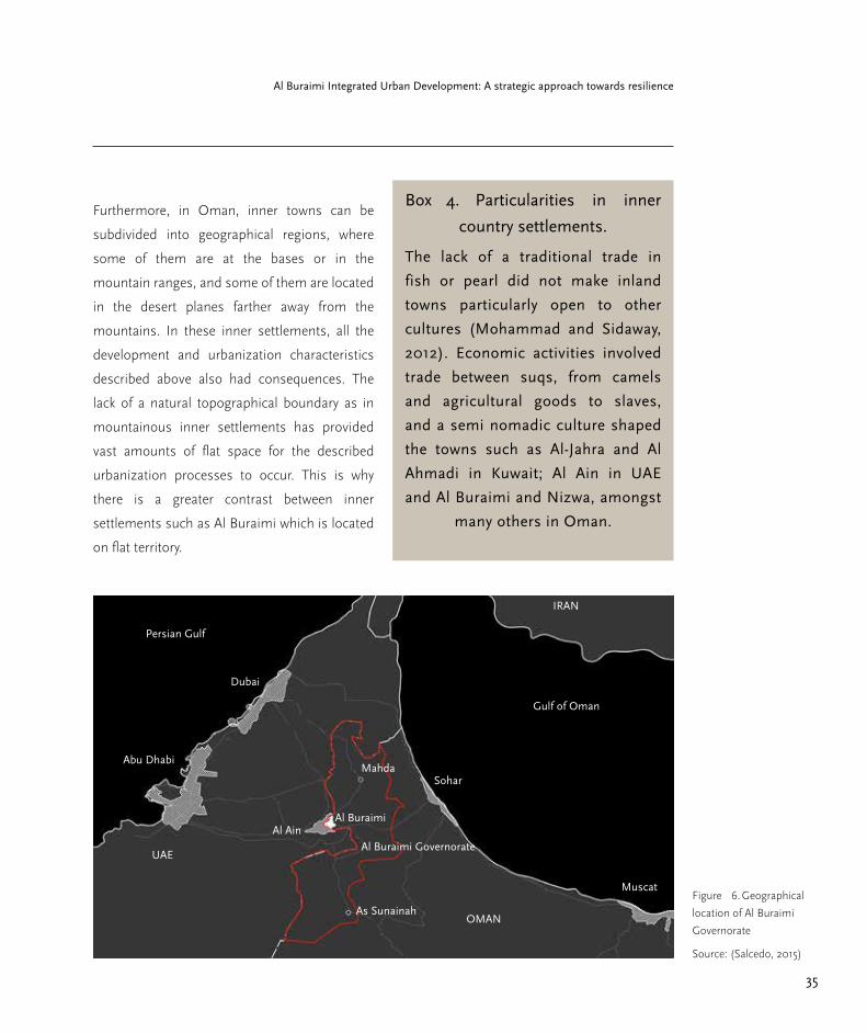
MuscatFigure 6. Geographical
location of Al Buraimi
Governorate
Source: (Salcedo, 2015)
Box 4. Particularities in inner
country settlements.
The lack of a traditional trade in
fish or pearl did not make inland
towns particularly open to other
cultures (Mohammad and Sidaway,
2012). Economic activities involved
trade between suqs, from camels
and agricultural goods to slaves,
and a semi nomadic culture shaped
the towns such as Al-Jahra and Al
Ahmadi in Kuwait; Al Ain in UAE
and Al Buraimi and Nizwa, amongst
many others in Oman.
36
Part 1. Current Trends and Challenges
History and urbanization in Al
Buraimi
The history of the area known as the Buraimi
Oasis is composed of various stages of
occupation by small groups that fought over
the control of the villages in the oasis. This was
mainly due to its geographical position linking
trading routes between the coasts of the Persian
Gulf and the Gulf of Oman.
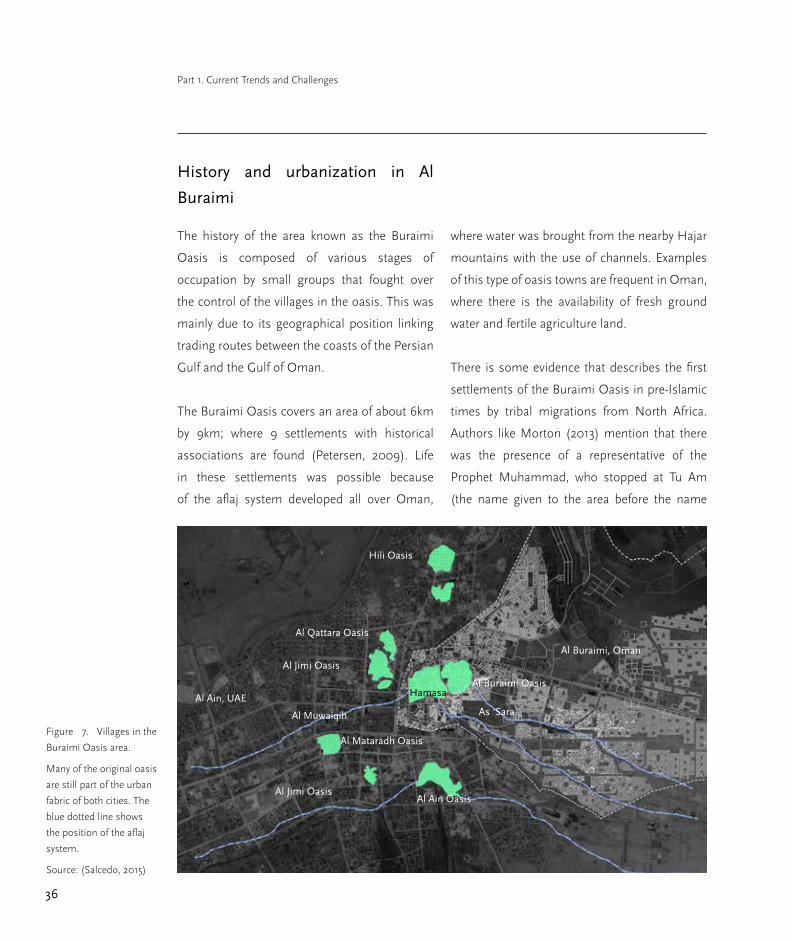
The Buraimi Oasis covers an area of about 6km
by 9km; where 9 settlements with historical
associations are found (Petersen, 2009). Life
in these settlements was possible because
of the aflaj system developed all over Oman,
where water was brought from the nearby Hajar
mountains with the use of channels. Examples
of this type of oasis towns are frequent in Oman,
where there is the availability of fresh ground
water and fertile agriculture land.
There is some evidence that describes the first
settlements of the Buraimi Oasis in pre-Islamic
times by tribal migrations from North Africa.
Authors like Morton (2013) mention that there
was the presence of a representative of the
Prophet Muhammad, who stopped at Tu Am
(the name given to the area before the name
Figure 7. Villages in the
Buraimi Oasis area.
Many of the original oasis
are still part of the urban
fabric of both cities. The
blue dotted line shows
the position of the aflaj
system.
Source: (Salcedo, 2015)
Al Buraimi, Oman
Al Ain Oasis
Al Muwaiqih
Al Mataradh Oasis
Hamasa
Al Jimi Oasis
Al Jimi Oasis
Al Qattara Oasis
Hili Oasis
Al Buraimi Oasis
As ‘SaraAl Ain, UAE

37
Al Buraimi Integrated Urban Development: A strategic approach towards resilience
Al Buraimi) in order to persuade the Sasanian
government to convert to Islam. Eventually,
Sheikhs at Nizwa agreed to convert to Islam
(Petersen, 2009) and the Sasanians were
expelled from the Oasis.
There is more information for the period
between the sixth century A.D. and 1700 where
different groups sieged and controlled the area,
expanding the few constructions present in the
oasis. The groups were very diverse; Abbasid
Caliphs of Baghdad, Ibadite and Sunni factions,
Wali’s from neighbouring villages in Oman,
and Sheikhs in the neighbouring Trucial Oman,
as well as Saudis that started to incurse to this
land around 1805. Founded on Wahhabism,
different groups led by Saudis invaded and took
over the control of the oasis. This led to several
fights between them and forces amassed by the
Sultans of Oman, in order to regain control of
the oasis.
Some of the first descriptions of the village and
its surroundings by western authors appear
around that time. Hammerton and S.B, Miles in
Petersen (2009) described Al Buraimi as a large
Figure 8. View of an aflaj
channel
still ocassionally used for
agriculture purposes in
the centre of Al Buraimi
Source: (Salcedo, 2015)

38
Part 1. Current Trends and Challenges
town with a strategic fort. They confirmed that
the surrounding villages had economic activities
that ranged from manufacturing in pottery,
weaving, ironworking, trappings, pottery trade,
farming of dates, alfalfa, oranges, mangoes and
root vegetables.
The Al Buraimi Oasis had twelve aflaj with an
average length of 7km. There were also two
main forts known as Al Illah and Al Khandaq
that comprise large rectangular structures. The
construction of this fort is attributed to the
Wahhabi’s between 1800 and 1818. The second
fort, recognizable by its moat, is considered to be
older from around 1808 to 1813. Petersen (2009)
argues that this moat typology is rather strange
in Arabia and in post-medieval fortifications.
One of the authors that describes the area
around the year 1959, is Wilfred Thessiger in
his book Arabian Sands (Thesiger and Stewart,
2008). He was in the Buraimi Oasis several
times making a four-day trip on camel from Abu
Dhabi. Thessiger mentions the existence of a fort
in Muwaiqih where his host, the Sheikh Zayid
resided. From there, he describes the existence
of enclosed spaces by mud walls, palm groves
and the stunning landscape of Jebel Hafeet, a
close by mountain, and the Omani mountains
range further away.
The “Buraimi dispute”
At those times, Saudi influence on the area was
very important, still Wahhabis were prominent
merchants and had control over slave-routes,
which flourished in two of the villages of the
Oasis. The political situation at those times
remained very delicate. Sheikhs would claim
power over its village, and not recognizing
the power that the Sultan of Oman had over
the area. This meant that power relied on the
support of tribe groups that each Sheikh would
amass by his own means.
Regionally, the Iraq Petroleum company had
already signed agreements with both the Sultan
of Oman and the Trucial Sheikhs in order to
explore the region around the Oasis, but without
any clear representation of the Sultan, and with
unstable rulings by the Sheikhs because of
disputes between the Al bu Falah of Abu Dhabi
and the bin Maktum of Dubai, the foreign
investment in petrol explorations was not
accomplished. This feudal system was a chronic
problem until the Al Buraimi dispute that ended
in the clear recognition of borders between, the
Former UAE and the Sultanate of Oman.
The events that preceded this dispute start with
the Saudi’s last incursion in 1952 when they
took over the village of Hamasa with armed

39
Al Buraimi Integrated Urban Development: A strategic approach towards resilience
forces, violating territory from Abu Dhabi.
This event known as the Buraimi Dispute was
even discussed on the United Nations Security
Council because of British and U.S. involvement
with the three governments in dispute, Oman,
Trucial Oman and Saudi Arabia. The situation
was delicate because the British had influence
and some support from both Trucial Oman and
the Sultan of Oman, and the U.S. from Saudi
Arabia.
Arbitration broke down until 1955 and Britain
encouraged the expulsion of the Saudis from the
area (Morton, 2013), ending up with the current
borders between Oman and UAE being drawn
right across the Oasis. Ever since then the area
known as the Buraimi Oasis is comprised of
nine different villages, Buraimi, As ´Sara and
Hamasa today on Oman; and Al Ain, Muwaiqih.
Mataradh. Jimi, Qattara and Hilli on UAE.
The Oasis after the conflict
Around 1955 after the Saudis had been expelled
from the Oasis, the situation for the inhabitants
was delicate. During the four years that Hamasa
was under the influence of the Saudis it had
received money and had seen its market activities
develop. With the expulsion of the Saudis, even
though the village itself was not destroyed, the
economy was left shattered (Morton, 2013).
Hamasa was estimated to have around 3,000
people, supporting the Sheikhs Rashid, Obaid
and Saqr, who under British pressure and fear
from further reprisals coming in from Muscat,
left to Saudi Arabia.
It is stated that during this short-term influence
of Saudis in Hamasa, the villagers also saw
better living standards with the investment that
the Saudis brought. They started to neglect their
agricultural activities and thus began the path
towards decadence of the Buraimi Oasis and
its agriculture. During that time, the Sultan in
Muscat spared no relief in helping the villages
in the Buraimi Oasis to be redeveloped; the aflaj
system was left in an abandoned state and even
though the Wali of Buraimi and the British were
collaborating to invest in Buraimi, the sultan
refused to cooperate financially with them
(Morton, 2013).
This is the starting point of the polarisation
in the economy of Al Ain in the UAE and Al
Buraimi in Oman. British investment came to Al
Ain in support with the Abu Dhabi Sheikh and
the aflaj was repaired and the suq became soon
a thriving place for the local economy.

40
Part 1. Current Trends and Challenges
Figure 9. Current state of
As Sara,
View of the centre of the
neighbourhood in Al
Buraimi Oasis.
Source: (Salcedo, 2015)
41
Al Buraimi Integrated Urban Development: A strategic approach towards resilience
Current trends
Linnear growth and shift in activities
The Governorate of Al Buraimi is distinguished
by being the cross point between Oman and
UAE. AL Buraimi serves as a commercial capital
where business thrives with Al Ain, Abu Dhabi
and Dubai. Al Buraimi is also a fast-growing
city; new housing areas are being laid out, as
well as commercial areas and governmental
offices. Besides this, recreational areas are being
designed and built too. Nonetheless, there is a
trend in expansion that is affecting the urban
development of the city and its villages.
Al Buraimi is growing in a linear fashion, mainly
along the highway route that connects the main
city with the UAE and with the rest of Oman.
This is due to a strong car-oriented development
and to the current land allocation policy. The
trend is that the city of Al Buraimi is becoming
linear, such as Muscat and many others in the
country, growing along a transport route, and
not oriented towards employment, education or
leisure locations.
The other trend analysed by this study is that the
shift from primary activities such as agriculture
and stockbreeding, into governmental offices
and a small percentage of the private sector.
Car dependancy
The transportation mode is car dependant due to
affordability in prices of cars and oil. Moreover,
there is a car-oriented culture embedded in
the society. This situation has led to high
automobile accident rates and considerable
areas of land dedicated to car infrastructure.
Therefore, walking distances or infrastructure
for non-motorized modes of transportation are
non-existent.
Service provision is challenging
Al Buraimi is growing horizontally and not
vertically. The people of Oman are used to
having their own land with their own house, thus
growth is happening towards the outskirts of the
city, where it is uncontrolled and very scattered,
without planned infrastructure for basic services.
The trend is that these services arrive after the
construction of houses, which creates a huge
problem to the people trying to inhabit these
areas. For this reason, infrastructure provision
and specifically the key services face a lot of
challenges.
Finally, solid waste management processes
cannot cope with the rapid growth of the city in
the absence of sustainable ways of solid waste
treatment.

42
Part 1. Current Trends and Challenges
People are living farther and more
disconnected from each other
The tendency for housing and land allocation
policy creates an urban tissue composed of
isolated single dwellings. The plots assigned
for housing are always delivered farther away
from the city centre, allowing houses to be built
disconnected from the city centre, its activities
or infrastructure systems. There is also a trend
in oversized housing plots with unnecessary
amounts of space between the designated plots.
The distance between dwellings prevents
people from bonding and cultivating a feeling of
belonging, therefore restricting social cohesion.
Physically, housing has taken an expensive and
inefficient direction as a consequence of the
city adopting typologies that do not cater to the
local environmental conditions. Consequently,
it results in high production, functional, and
maintenance costs for the city.
Traditional culture is dissapearing
The corresponding increase in internal
emigration for work has reduced the rate
of family cohabitation with the number of
inhabitants in a household decreasing. Besides
this, the introduction of novel home designs
and building materials has displaced traditional
building techniques and materials; changing the
traditional aspect of the city towards a modern
appearance.
Additionaly, Hamasa was once a major market,
but nowadays is deteriorated due to neglect and
environmental degradation. The settlement is
now largely uninhabited, offering little incentive
to potential new residents. There is a tendency
toward abandonment of heritage and cultural
assets, and the decay of the sense of identity
among the community. Besides this, new
administrations in the Ministry of Heritage and
the Ministry of Tourism do not propose actions
in order to increase the attachment towards
these assets. Sites as Hamasa are prone to
disappear.

43
Al Buraimi Integrated Urban Development: A strategic approach towards resilience
Figure 10. Lost oasis
and heritage
Source: (Salcedo, 2015)
Figure 11. A street in
Sa ‘ara, Al Buraimi
Source: (Carvajal, 2015)

44
Part 1. Current Trends and Challenges
Current challenges
Curve and re-direct growth
The future challenge is to withstand this linear
growth and try to curve it. By this, an effort
to concentrate growth on specific nodes is
necessary. Precise areas in the city centre have
to be made attractive for development to occur,
as well as some foci in the peripheries have to
be detected in order to start a clustering process
for neighbourhood creation.
There are two important things that must occur.
Firstly that growth is curved and drawn back
to shorter distances for activities to occur, and
with this: better practices and technologies for
an adequate natural and man-made resource
management get implemented. The second is
to prevent primary activities from disappearing,
resulting in the Governorate eventually being
on the verge of resource scarcity.
Review and reformulate mobility
The national policy and the legal framework
need to be reviewed to overcome the challenge
of car dependency. In addition, it is necessary to
create proximity through higher densities and
mixed land uses. Thus, the land distribution
policy and building codes might be reviewed.
Another challenge is to raise public awareness
on sustainable transportation to reduce car
use. At the same time, the implementation of
facilities for non-motorized transportation plays
an essential roll to minimize car domination.
Issues such as inaccessibility, pollution, high
noise level, high congestion, among others,
still do not represent an urgent challenge for
the city. Nevertheless, if the urban area keeps
growing at the pace of the previous years and
the new developments continue with the same
urban planning system, the city may face the
aforementioned challenges in the short and
medium term.
Box 5. Diverse nature of challenges
In order to accomplish these regional challenges, the Governorate can focus
on improving the following: building codes, natural resource management
regulations, natural resource technologies, promote better land uses in the city
centres and peripheries. Moreover, promote agriculture and livestock activities,
within better water management practices and technologies.

45
Al Buraimi Integrated Urban Development: A strategic approach towards resilience
Cope with demand
The Municipality will be unable to cope with
the demand of water and basic services, and
the ever growing population and distances
between every new household. The challenge is
to address this as well as to tackle the growing
demands of solid waste management, and the
capacity for wastewater management.
Enhance housing and neighbourhoods
Another challenge is to enhance the
constructions performance in order for them
to have better energy saving and bioclimatic
standards. The opportunity lies in utilizing
land and energy for the development of the city
environment as a whole. Housing’s contribution
for the improvement and functioning of urban
growth is achieved when it is not seen as isolated
constructions but as units within a larger
functioning organism; the neighbourhood.
Re-awaken culture
The future challenge is the revival of the
abandoned settlement of Hamasa. Mud-brick
construction is a valuable vernacular technique
in oasis settlements, and along with the physical
loss of the house structures, the knowledge of
such building traditions is also in danger of
being lost to future generations. The loss of
the intangible heritage represents the death of
a part of the community’s identity; therefore
there is a great urge to promote the importance
of heritage assets among the young population.
Finally, the challenge is to invest in capacity
building in order for community members to
have improved future input in decision-making.
Box 6. Land availability
The municipality faces the problem
of not possessing vacant land for
further plot allocation despite having
most of its territory not yet built. This
involves the setting of reforms for
land delivery procedures. Therefore
the challenge is to develop reforms
within the land delivery procedures
and to distribute plots in areas
already in an urbanized state.
46
Part 1. Current Trends and Challenges
SWOT analysis
After presenting the development of the
Governorate, its current trends and challenges,
this study presents a SWOT analysis. It is an
easy way to classify preliminary findings into
strengths, weaknesses, opportunities and
threats. It therefore identifies the strong and
weak points of the city and villages and helps to
quickly show what can be exploited and profited
from, or what can harm the region.
In the case of threats and opportunities, a wider
scope for analysis is encountered as these two
are frequently external or the city may have no
control over them. Threats can include factors
related to national urban environment, political
context, trade agreements, infrastructure, etc.
The role of the analysis is to identify if they are
contributing to the development or if they are
exposing the city to problems.
On the other hand, the SWOT analysis serves
as a guideline to propose alternative scenarios
for development. The use of scenarios is
helpful in order to present possible outcomes
to stakeholders (Cities Alliance, 2011). Similarly,
the study presents many options out of the
SWOT analysis, in order for local authorities to
work towards a collective decision and to gain
ownership whilst choosing the option that they
find more suitable.
Strengths
Geographical position and young
population
There are two main strengths on the regional
scale. One of them is the geographical position;
the Governorate lies on the Crossroads between
growing metropolitan areas, Sohar, Nizwa, Abu
Dhabi and Dubai. This is already fuelling the
economy and business of the city, but it can still
be exploited even more. The second strength
are the human resources; the Governorate has a
big young educated population that need to find
places to work and live in order not to go outside
of the region in search of better opportunities.
Sustainability awareness
There is an increasing awareness about
environmental sustainability among the
government institutions. Additionally, the
Governorate of Al Buraimi and ministries are
seriously considering the improvement of
citizens’ quality of life. This can be seen in how
the local government is open to new ideas for
urban development, protecting the local identity,
and cultural value, for instance.

47
Al Buraimi Integrated Urban Development: A strategic approach towards resilience
Investment in sustainable
infrastructure
The main strength is that the majority of
population is connected to a water system;
almost the 80 per cent. Besides this, the new
wastewater treatment plant is another strong,
which is very modern even though it still does
not cover the entire city, but marks a big leap
in the improvement of wastewater handling.
Additionally, residents’ eagerness to participate
in recycling and waste separation projects is a
good strength on which to profit.
Equality of tenure
One of the main strengths is the intention to
keep land and housing tenure possibilities equal
among citizens. This is the main reason the
lottery method was considered for distributing
land.
Another beneficial aspect is the propensity
for a more distinctive architectural style or
elements for the city making it consequently
more homogenous. Additionally, land remnant
availability can be used to link residences among
each other if given an intentional public open
space character.
Pride through identity
The main quality Hamasa possesses is the
ability to give a sense of pride to the community;
the mud brick-houses are part of the identity
and belong to the cultural heritage assets of the
area, making the site unique. Its location is also
beneficial; near to the Al Ain border in the U.A.E.
and within the city. it is also next to the Fort Al
Hillah and Fort Khandaq.
Box 7. Strengths
Geographical position and human
resources
Environmental sustainability
awareness
Water network connection
Wastewater improvement
Equality in tenure possibilities
Homogenous cityscape
Cultural identity
Location of heritage assets
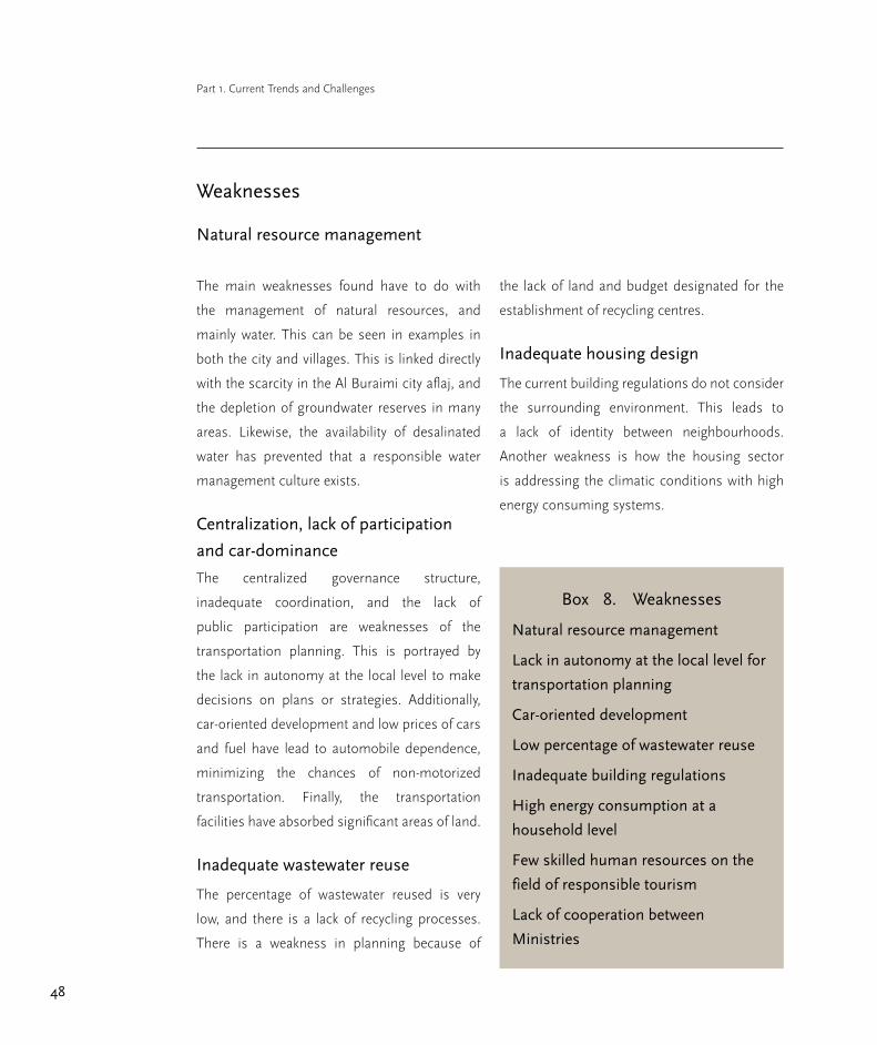
48
Part 1. Current Trends and Challenges
Weaknesses
Natural resource management
The main weaknesses found have to do with
the management of natural resources, and
mainly water. This can be seen in examples in
both the city and villages. This is linked directly
with the scarcity in the Al Buraimi city aflaj, and
the depletion of groundwater reserves in many
areas. Likewise, the availability of desalinated
water has prevented that a responsible water
management culture exists.
Centralization, lack of participation
and car-dominance
The centralized governance structure,
inadequate coordination, and the lack of
public participation are weaknesses of the
transportation planning. This is portrayed by
the lack in autonomy at the local level to make
decisions on plans or strategies. Additionally,
car-oriented development and low prices of cars
and fuel have lead to automobile dependence,
minimizing the chances of non-motorized
transportation. Finally, the transportation
facilities have absorbed significant areas of land.
Inadequate wastewater reuse
The percentage of wastewater reused is very
low, and there is a lack of recycling processes.
There is a weakness in planning because of
the lack of land and budget designated for the
establishment of recycling centres.
Inadequate housing design
The current building regulations do not consider
the surrounding environment. This leads to
a lack of identity between neighbourhoods.
Another weakness is how the housing sector
is addressing the climatic conditions with high
energy consuming systems.
Box 8. Weaknesses
Natural resource management
Lack in autonomy at the local level for
transportation planning
Car-oriented development
Low percentage of wastewater reuse
Inadequate building regulations
High energy consumption at a
household level
Few skilled human resources on the
field of responsible tourism
Lack of cooperation between
Ministries

49
Al Buraimi Integrated Urban Development: A strategic approach towards resilience
Lack of capacity building and
cooperation
There is a weakness in terms of capacity
building as there are little human resources that
are skilled in the field of responsible tourism, as
well as a weak tourism diffusion from both the
Ministry of Tourism and the Ministry of Heritage,
also portrayed by their lack of cooperation in the
matter. Finally, the lack of interest on a fraction
of the community is also a weakness for the
development of Hamasa.
Opportunities
Introspection of the economy
The closing of the border with Al Ain can
represents some negative issues, such as Al
Buraimi locals have more trouble profiting
from the opportunities Al Ain offers in terms of
commerce and education due to congestion at
the check points and vice-versa. Nonetheless,
this new border has begun a slow but good
process of introspection of economy into Al
Buraimi. This is an opportunity to invest in
businesses, local know how (i.e.: clusters) and
education; enhancing spaces inside the city so
that businesses and more types of uses appear
(i.e: worship, education, commerce).
Sunlight
Al Buraimi has unlimited amounts of sunlight
that could be used to generate renewable energy
in many different ways.
Smart growth
The Sultanate of Oman has enough financial
resources from the oil industry, which
could be invested in innovative sustainable
transportation. There is still time for smart
growth by reformulating the current planning
processes and switching into a more sustainable
mode of transportation.
Box 9. Opportunities
Investment in local know-how and
clusters
Investment in education
Investment in solar energy
Switch into sustainable transportation
Creation of a water saving culture
Creation of a recycling culture
Solar energy at a household level
Creation of jobs in the tourism sector
Re-introduction of vernacular building
and art craft techniques

50
Part 1. Current Trends and Challenges
Recycling and saving culture
The residents’ willingness in saving water could
be used to foster better water saving plans, as
well as introducing recycling at all levels. The
performance and lifetime of the current landfill
can also be improved.
Learning from abroad
There is room for change in housing, as most
of the land stock remains un-built. There is also
the possibility of learning from better practices
elsewhere, and use them as references for better
planning strategies.
New economic activities
By developing the area of Hamasa within
responsible tourism criteria, new job
opportunities can be created. Additionally,
reintroducing vernacular building techniques
and with them, a sense of identity amongst Al
Buraimi locals. Finally, art craft production can
also be re-introduced, such as basketry and
pottery.
Threats
High costs of development and
resource dependancy
This study claims that the land allocation policy,
combined with the particular oil-economy in
Oman and governmental strategy, has produced
the scattered urbanization process, and this is
the origin of most constraints, weaknesses and
eventually threats. They include the high cost
of infrastructure and service delivery, as well as
resource dependency and scarcity. The rise in
costs exists on two levels. First of all on a utilities
level including water, wastewater, electricity, etc.;
and secondly on a typological level including
roads, schools, clinics, commerce, etc. The
growing dependency on basic natural or man-
made resources such as water or food is
increasing; therefore the risk for the Governorate
of having resource scarcity in the future if ever
the economy changes abruptly is very likely.
Inequality in mobility and health risks
Inequality and unfair accessibility for vulnerable
groups are threats for community development
and social cohesion. In addition, public health
and security is permanently threatened by
the car-oriented development. This mode
entails ecological threats such as pollution,
contamination, high levels of noise, and
destruction of the local ecosystems.

51
Al Buraimi Integrated Urban Development: A strategic approach towards resilience
Box 10. Threats
Rise in infrastructure and service costs
Resource scarcity
Inequality and unfair accessibility to
transport for vulnerable groups
Costs of externalities attributed to car-
oriented development
Increased water demand
Reluctance to reuse treated water
Landfill threat to public health and the
environment
Disintegration of the urban structure
because of the land allocation policy
Loss of intangible and cultural assets
Growing water demand and waste
Issues associated with water demand include
the major drought periods caused by climate
change, and straining by the population.
Moreover, there is a general reluctance on behalf
of the community to reuse treated water i.e.: for
the irrigation of the grass in the green spaces.
Another threat is that the current landfill is very
close to the residential area and it does not fulfil
the technical requirements, posing a threat for
the environment and the health provision of the
area.
Scarce land stock
There is a lack of vacant land within Al Buraimi
to supply the housing demand for the following
lottery applicants. Talks with the neighbouring
wilayat of Mahdah have already begun to
negotiate the use of their land. The further
disintegration of the city and its residential areas
affects social cohesion and enlarges many of the
urban issues aforementioned i.e.: costs.
Loss of intangible assets
The lack of interest from the community, and
the loss of attachment to heritage and cultural
assets. Besides this, political factors affect the
creation of awareness campaigns promoting
the importance of the site. This can lead to a
permanent loss of such assets.

52
Part 1. Current Trends and Challenges
Al Buraimi 2030; a vision for a
resilient future
The Governorate of Al Buraimi can be the place
where inner land settlements revive an Omani
culture that has stagnated over the last 40
yearsVision 2030
New neighbourhood units and housing
typologies occur on a small but condensed
level, where small day-to-day activities can occur
within footsteps of each household. People can
walk through cool, shaded pedestrian streets
and head to the mosque, store, school, coffee
shop, etc. without having the need to use their
cars. Neighbourhoods also allow people to
interact on a daily basis with their neighbours;
social cohesion is constantly increasing.
On a household level, Al Buraimi produces
more than half the electricity needed with the
use of solar panels, and the remaining fraction
of electricity provided to the Governorate is used
for purposes other than housing. People have a
water conservation mind-set and everything is
recycled to the last drop. There is also a growing
trend in people growing small amounts of fruit
and vegetables in their own households.
In the villages, agriculture remains a strong
economy, and the products from local farms are
sold locally at Al Buraimi as they have the best
quality and are grown with sustainable practices.
Products that come from neighbouring Mahda
and As Sunainah are more valued than products
that come from other regions or countries, based
on their responsible and organic production
practices.
On a municipal level, Al Buraimi has a strong
control on how to deliver services. This is
done according to urban growth management
instruments, where growth is fostered in
clustered units and not in a linear or concentric
manner. This means that the Governorate
constantly monitors the growth patterns of
its city and villages and delivers utilities and
services to places where more units are built
together; likewise, it taxes the development
of land in areas outside of “adequate public
facility ordinances” (APFO) and promotes the
development of land inside them with the use of
building incentives. This is mainly governed with
a renewed building code and building permits.
Development in Al Buraimi is also encouraged
to occur rapidly in some areas. The city centre
and the oasis are places coveted for the
development of housing and commerce, and
the living conditions here are preferable for
residents that want to experience the benefits of
shorter commutes and mixed-use typologies.
53
Al Buraimi Integrated Urban Development: A strategic approach towards resilience
Al Buraimi works as a hub for business and
commerce between cities in Oman as Sohar and
Nizwa, and cities in the UAE; providing places
for conferences, meetings, as well as all types
of leisure and commercial activities surrounding
the central Oasis and reclaimed heritage zone.
Al Buraimi and its villages are now proof that the
Omani way of living is unique and can be in line
with best practices towards the environment.
The city has also adopted smart growth
strategies, minimizing land occupation for car
facilities, and reducing automobile dependency
whilst prioritizing pedestrians. In addition,
residents are made aware of the importance
of adopting environmentally friendly practices.
Furthermore, public transportation is
implemented and functioning throughout the
city with the aim of providing a sustainable
choice of transport for everyone.
Additionally, the city has minimized the use
of non-renewable resources, the impacts on
the natural environment and protects the local
biodiversity whilst fostering the use of renewable
resources. Furthermore, the city and region has
managed to secure safe access to fresh water for
all the residents through an adequate network,.
It has also managed to introduce a solid waste
management network that covers the entire
city . This system is based on recycling, and a
sewage network that has a high percentage of
reused treated wastewater. Al Buraimi residents
are aware of the importance of adopting more
environmentally friendly practices towards the
use, reuse and conservation of water, as well as
separating and recycling their solid waste.
Neighbourhoods are recognized by their
harmonized appearance, which reinforces
the community’s identity. They are also
interconnected with thoroughfares, for residents
to access the different vicinities. Moreover,
neighbourhoods are thriving with pleasant
resting squares and areas to pause from the
heat and daily stress. Al Buraimi is a city that is
used as an example in the rest of Oman, due to
its innovations with bioclimatic and high energy
savings in buildings.
Finally, the revitalization of Hamasa has
been accomplished and the involvement of
the community towards the tourism sectors
has been acknowledged. Training and skill
development became key elements in order to
revive the oasis settlement of Hamasa, so as to
become a national tourist attraction.

54
Part 1. Current Trends and Challenges
Box 11. Rising problematic
Many issues that are arising in Al Buraimi are common to other places in the
world. They have to do with rapid growth of urban areas, the shift from primary
activities into the service and governmental sector, a growing migratory profile
as well as a growing young population, a strong car oriented development, a
reliance on external natural and man-made resources, the lost of identity and
heritage, the reliance on non-renewable sources of energy. Finally , an ever
growing distance between housing units that has an overall effect of spreading
all the aforementioned problems into long distances for them to be tackled.
Besides this, rising living costs are a reality: portrayed by electricity, water, fuel,
construction costs; time spent commuting and increasing health problems.
The need for a paradigm shift
Omani development in inner settlements has
been shaped by a distinctive trade and caravan
commerce; by an amazing water system and
agricultural activities related to it, and within
architectural typologies of great value to
Omani heritage. This shaped cities such as Al
Buraimi that relied on commercial routes from
the Omani coastal towns into the UAE shores.
Towns developed around the Oasis that were
fed by the aflaj, and in turn fed the inhabitants
with produce and cooler temperatures.
This has been distorted during the last 50 years.
A shift from semi-nomadic activities into a
sedentary modernization, facilitated by a rich
oil industry and the creation of employment in
the governmental sector, has occurred rapidly
and the traditional way of living is now mere
history. Omani modern life is also shaped by
the consequences of the land allocation policy,
which has allowed equal opportunities of tenure
to arise between all Omani nationals.
This study makes the claim that Al Buraimi has
the opportunity to shift from this paradigm of
development that Omani culture has undergone
during the last 40 years, and start to direct it
toward long-term strategies. This can be framed
within the well being of the majority, an efficient
use of natural resources and conservation of the
ecosystem, a shift in household typologies, in
better technologies related to service provision,
in better transportation modes, in better
economic opportunities in the regional level and
the reconnection to lost heritage and culture.
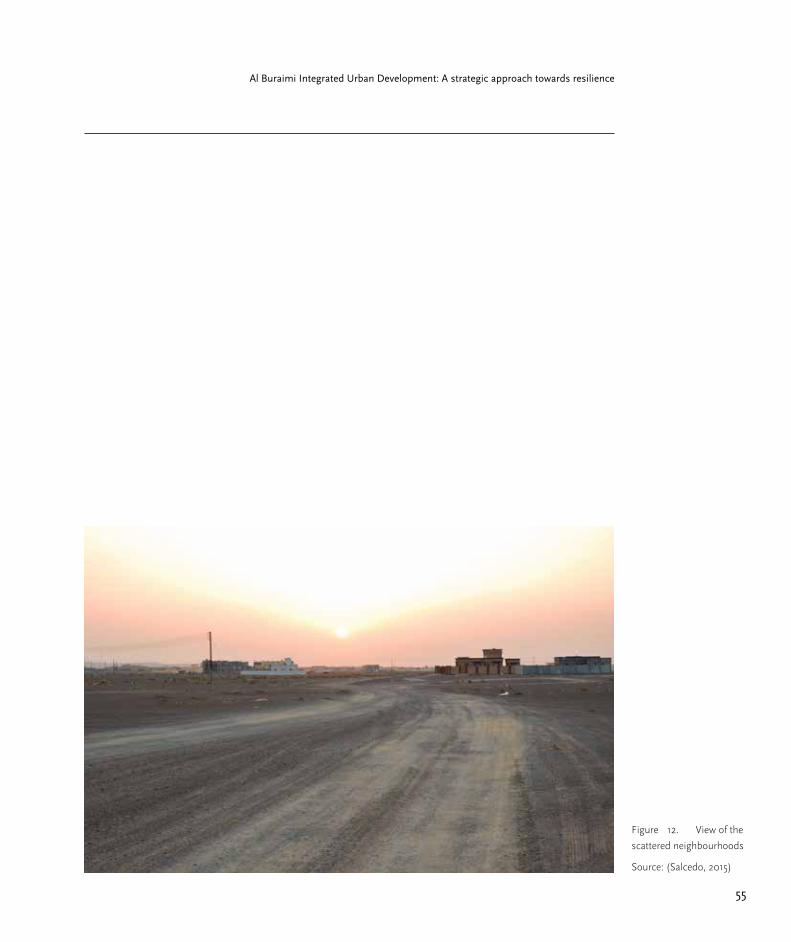
55
Al Buraimi Integrated Urban Development: A strategic approach towards resilience
Figure 12. View of the
scattered neighbourhoods
Source: (Salcedo, 2015)

Part 2.1 Regional development & growth managementJesús Salcedo V.

The following study presumes that if
development continues in the current manner,
disparities amongst social groups will grow
rapidly and the region will be reliant on external
resources; moving further apart from any
aspiring resilience thus always having the risk
of resource scarcity, worse living conditions
and disparities, as well as a deteriorating quality
of life. The following chapter sheds light on
the process that has resulted in Al Buraimi
Governorate’s urban and regional state. In
order to do so, a geographical and socio-
economical analysis is presented, as well as a
spatial overview of the urbanization process in
the Governorate. The major advantages and
disadvantages regarding spatial development
are drawn and with them, a strategy is framed.
A set of criteria that can improve the spatial
living conditions is presented. It is theoretically
framed under the urban growth management
field. Additionally, The study proposes a set of
recommendations in the shape of instruments
for urban growth management, as well as maps
that illustrate how can they be applied in the
short, medium and long term. The purpose
of the recommendations is to redirect the
Governorate’s development strategy toward
improving and profiting from its assets, to
improve its use of natural resources and public
space, as well as the policies that will curve
the ever growing sprawl, by shifting into a new
set of criteria regarding urban and regional
development.

58
Part 2.1 Regional Development and Growth Management
Assesment of the current
state
Taking into account that the problematic of
the Governorate has been presented, the
following study starts with a brief analysis of
different geographical, economic, social and
spatial factors that affect the Governorate as a
region. Afterwards it explains the strategy and
instruments recommended.
Climate, Temperature and rainfall
According to the statistics, the maximum
temperatures recorded for Al Buraimi since
2002 have risen considerably. In other terms,
the last 5 years have been the hottest; reaching
maximums of 48 C. Likewise rainfall has been
very irregular and scarce during the last five
years. From 2002 to 2006 the lowest amount
recorded was 36mm of rainfall, and from
2007 to 2012 the lowest recorded was 12mm.
Moreover, averages for these two periods are
67mm and 38.6mm. In terms of weather and
water resources Al Buraimi is one of the hottest
and underprivileged in Oman.
Water Resources
Historically the Buraimi Oasis was a source of
many products that were cultivated thanks to
Figure 13. Maximum
and minimum
temperatures in Al
Buraimi Governorate.
Source: NCSI, modified by
author
Previous page:
Agriculture in Hafeet, Al
Buraimi Governorate
Source: (NCSI, modified
by author).

59
Al Buraimi Integrated Urban Development: A strategic approach towards resilience
the aflaj system, its use being spread all around
the country. The aflaj allowed ground water
from nearby mountains to be transported as far
as the agricultural lands in the Buraimi Oasis
villages, where mainly date palm was cultivated.
Nowadays, the two main oases that are still in the
Omani side are a mere glimpse of the splendour
that the aflaj system allowed to flourish. Around
10 years ago, the water flow from the aflaj system
was almost exhausted do to a rapid increase
in water use in the surroundings. The fast
urbanization of Al Buraimi and Al Ain used most
of the ground water available until the point of
drying up the source of the aflaj (MOM, MECA).
It is still uncertain to the Al-Buraimi government
if most of the responsibility of drying up the
ground water is due to the extraction by wells.
Decline in agricultural activities
The rapid urbanization and its direct increase on
the demand for water is not the only cause of
the abandoned state of Al Buraimi’s agriculture.
The process which the country undertook since
the 1970’s to improve the industry and provide
better employment for Omanis as well as
fostering the sedentariness of many nomads
(Janzen, 1983, p.292) is also the reason why a
diversification of employment was introduced.
Later on, activities that resulted more attractive
in terms of revenues and man labour started
Figure 14. Average
rainfall in Al Buraimi
Governorate
Source: (NCSI, modified
by author)
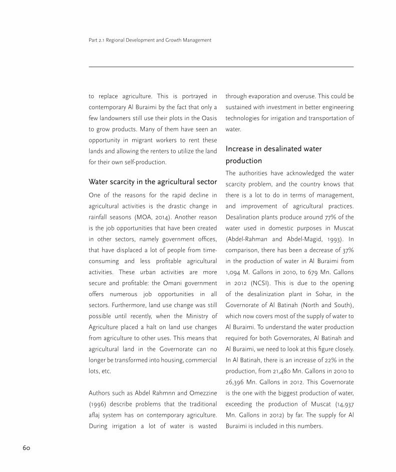
60
Part 2.1 Regional Development and Growth Management
to replace agriculture. This is portrayed in
contemporary Al Buraimi by the fact that only a
few landowners still use their plots in the Oasis
to grow products. Many of them have seen an
opportunity in migrant workers to rent these
lands and allowing the renters to utilize the land
for their own self-production.
Water scarcity in the agricultural sector
One of the reasons for the rapid decline in
agricultural activities is the drastic change in
rainfall seasons (MOA, 2014). Another reason
is the job opportunities that have been created
in other sectors, namely government offices,
that have displaced a lot of people from time-
consuming and less profitable agricultural
activities. These urban activities are more
secure and profitable: the Omani government
offers numerous job opportunities in all
sectors. Furthermore, land use change was still
possible until recently, when the Ministry of
Agriculture placed a halt on land use changes
from agriculture to other uses. This means that
agricultural land in the Governorate can no
longer be transformed into housing, commercial
lots, etc.
Authors such as Abdel Rahmnn and Omezzine
(1996) describe problems that the traditional
aflaj system has on contemporary agriculture.
During irrigation a lot of water is wasted
through evaporation and overuse. This could be
sustained with investment in better engineering
technologies for irrigation and transportation of
water.
Increase in desalinated water
production
The authorities have acknowledged the water
scarcity problem, and the country knows that
there is a lot to do in terms of management,
and improvement of agricultural practices.
Desalination plants produce around 77% of the
water used in domestic purposes in Muscat
(Abdel-Rahman and Abdel-Magid, 1993). In
comparison, there has been a decrease of 37%
in the production of water in Al Buraimi from
1,094 M. Gallons in 2010, to 679 Mn. Gallons
in 2012 (NCSI). This is due to the opening
of the desalinization plant in Sohar, in the
Governorate of Al Batinah (North and South),
which now covers most of the supply of water to
Al Buraimi. To understand the water production
required for both Governorates, Al Batinah and
Al Buraimi, we need to look at this figure closely.
In Al Batinah, there is an increase of 22% in the
production, from 21,480 Mn. Gallons in 2010 to
26,396 Mn. Gallons in 2012. This Governorate
is the one with the biggest production of water,
exceeding the production of Muscat (14,937
Mn. Gallons in 2012) by far. The supply for Al
Buraimi is included in this numbers.
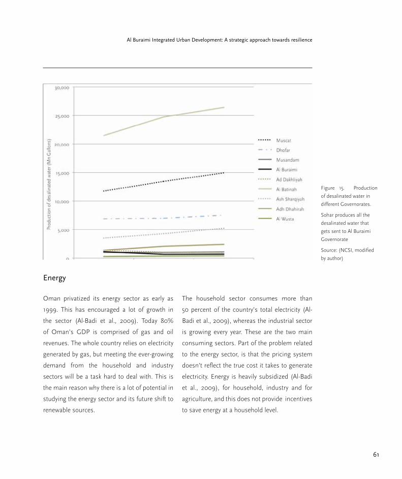
61
Al Buraimi Integrated Urban Development: A strategic approach towards resilience
Energy
Oman privatized its energy sector as early as
1999. This has encouraged a lot of growth in
the sector (Al-Badi et al., 2009). Today 80%
of Oman’s GDP is comprised of gas and oil
revenues. The whole country relies on electricity
generated by gas, but meeting the ever-growing
demand from the household and industry
sectors will be a task hard to deal with. This is
the main reason why there is a lot of potential in
studying the energy sector and its future shift to
renewable sources.
The household sector consumes more than
50 percent of the country’s total electricity (Al-
Badi et al., 2009), whereas the industrial sector
is growing every year. These are the two main
consuming sectors. Part of the problem related
to the energy sector, is that the pricing system
doesn’t reflect the true cost it takes to generate
electricity. Energy is heavily subsidized (Al-Badi
et al., 2009), for household, industry and for
agriculture, and this does not provide incentives
to save energy at a household level.
Figure 15. Production
of desalinated water in
different Governorates.
Sohar produces all the
desalinated water that
gets sent to Al Buraimi
Governorate
Source: (NCSI, modified
by author)

62
Part 2.1 Regional Development and Growth Management
Figure 16. Omani
population pyramid in Al
Buraimi Governorate in
2012
Source: NCSI and Author,
2014
Figure 17. Expat
population pyramid in Al
Buraimi Governorate in
2012
Source: NCSI and Author,
2014

63
Al Buraimi Integrated Urban Development: A strategic approach towards resilience
Population
Population has been increasing during the
previous years, mainly due to the creation
of the Governorate and the increase in
employment in the government sector. There
was a population growth of 22.8% from 72,917
people in 2010 to 89,564 in 2012. If we look at
the data in terms of nationals and expatriates
there are some interesting findings. There is
an increase in nationals of 6.93% from 43,026
in 2010 to 46,004 in 2012; and an increase of
expatriates of 45.73% from 29,891 in 2010 to
43,560 in 2012. Most of the expatriates come
from India, Pakistan, North Africa, Indonesia
and the Philippines. This means that as of 2012
expatriates make up 48% of the population in
Al Buraimi Governorate. This same growth
has been contrasting in the two villages of the
Governorate. Omani growth in As Sunainah has
been 7.19%, but expats have decreased by 86%.
In Mahda, Omani growth has been 6,92% as in
Al Buraimi; but expats have decreased by 69%.
This means that there are more employment
opportunities for expats in the city of Al Buraimi.
Trade and clusters
Oman’s economy can be regarded as a shift
from traditional trade and feudalism into
oil industries, governmental sector, and
entrepreneurship. Moreover, the economy in the
country can be separated as the activities taking
part in the coast and activities taking part in
the inner settlements. Until 1970 the economy
of the country was characterized by this duality,
where the ports traded dynamically with each
other and those of other countries (Speece,
1989); then with second category ports, and
small settlements; and only then would they
connect through the rough country’s topography
with established trade routes into the inner
settlements. These were places where caravan
trade occurred, and only if the demand for trade
and the population were large enough, bazaars
and suqs would be established as permanent
structures.
Trade in Al Buraimi
S.B. Miles in (Speece, 1989) described the
market activities in Al Buraimi in 1877 as “one
of the small markets. It had no proper bazaar;
trade was done almost entirely by barter at an
open-air market”. Today, the Al Buraimi suq is
only a remnant of any splendour that it could
have actually had in recent years. The area of
Hamassa at the middle of the 20th century had
the main buildings that hosted different types
of commerce, (Phillips, 1972) and slave trade
continued well beyond the 1950s.
Today in there is amongst smaller activities
like the construction sector and the quarries,
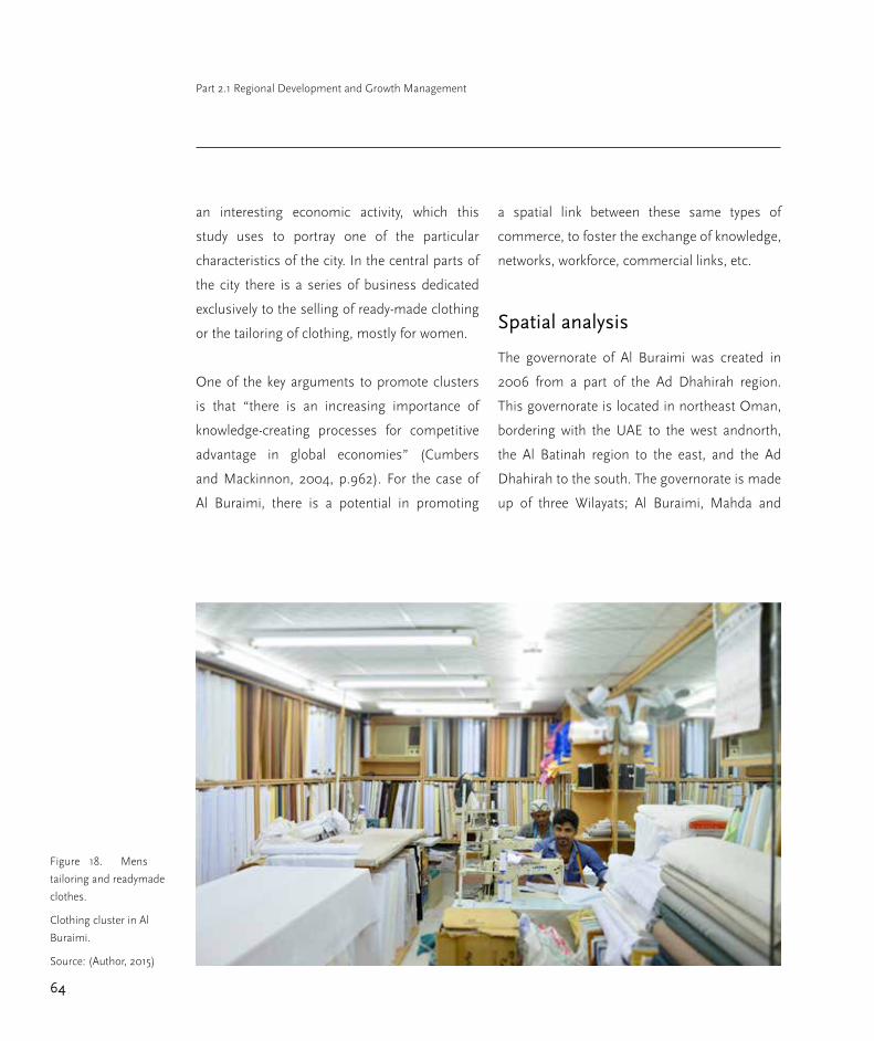
64
Part 2.1 Regional Development and Growth Management
an interesting economic activity, which this
study uses to portray one of the particular
characteristics of the city. In the central parts of
the city there is a series of business dedicated
exclusively to the selling of ready-made clothing
or the tailoring of clothing, mostly for women.
One of the key arguments to promote clusters
is that “there is an increasing importance of
knowledge-creating processes for competitive
advantage in global economies” (Cumbers
and Mackinnon, 2004, p.962). For the case of
Al Buraimi, there is a potential in promoting
a spatial link between these same types of
commerce, to foster the exchange of knowledge,
networks, workforce, commercial links, etc.
Spatial analysis
The governorate of Al Buraimi was created in
2006 from a part of the Ad Dhahirah region.
This governorate is located in northeast Oman,
bordering with the UAE to the west andnorth,
the Al Batinah region to the east, and the Ad
Dhahirah to the south. The governorate is made
up of three Wilayats; Al Buraimi, Mahda and
Figure 18. Mens
tailoring and readymade
clothes.
Clothing cluster in Al
Buraimi.
Source: (Author, 2015)

65
Al Buraimi Integrated Urban Development: A strategic approach towards resilience
Sunainah. The city of Al Buraimi is the capital of
the governorate, and it lies directly on the border
with the UAE, adjacent to the city of Al Ain on
the other side of this international border.
Land allocation policy
The main factor that has shaped the spatial
structure of cities in Oman is the land allocation
policy that was implemented in 1984. The
conditions in which people receive the plots are
very basic. Most of the time plots are allocated
in areas of the city where no development
has occurred yet, because the Ministries plan
and layout new areas where development will
expand and then distribute the land. There is no
obligation to build on the plots, people have the
choice of using these plots to build housing, to
sell, rent or trade them. In consequence, there is
a large amount of plots that get distributed but
that undergo no development.
Regarding infrastructure, the plots are normally
serviced with electricity during the first year.
Road infrastructure is not necessarily provided;
this decision is made according to the budget
allocations of the Ministry of Transport and
F
ED
G
CA
Al ainAl Buraimi
B
Figure 19. Spatial
charachetristics in Al
Buraimi
A: Minimum development
took place at the sand
dunes
B: Oasis
C: As’ Sara
D: Al Khadra
E: New park and sports
complex
F: Main east-west axis
G: large extensions of
allocated land
Source: (CNES / Astrium,
CNES/ Spot Image,
Digital Globe, modified by
author., 2014)

66
Part 2.1 Regional Development and Growth Management
Communication (MOTC) which are different in
time with the expansion plans of the Ministry of
Municipalities, from which water, sewage and
waste handling is provided. Another secondary
factor that affects the willingness to build on the
plots or not, is the preference for Omani’s to
live close to their relatives. Thus, once land is
allocated they also try to buy and sell in order to
group themselves and build close to each other.
This policy, along with its consequences in
terms of services, gave its spatial characteristics
to the urban growth of cities like Al Buraimi.
During the 1990s the policy was modified and
the standard plot size was raised. Ever since,
the areas distributed vary between 600m² to
900m²; with obvious consequences to the
rapid scattered sprawl of the cities in Oman.
Moreover, there was a turn in the events when
the scattered sprawl reached unprecedented
scales, because as of 2008 women are also
eligible to a plot (MOH, 2014). This doubled
the demand of applications, and thus the
land allocated for housing extended farther
and farther away from the city centres, around
10km of linear expansion during the last 8 years
(MOM, 2014; MOH, 2014).
Big plans, unexpected changes
The most interesting changes in Al Buraimi’s
urbanization process are related to housing.
Between 1984 and 1986 expansion plans were
laid out for the city. During that time housing and
economic activities were mainly concentrated to
the south of the Oasis, still thriving with palm
groves. Housing settlements could be found
between the Oasis and the southern border
with Al Ain. This border was just a political
one, but there was no control from either of
the countries, meaning that locals could cross
between Al Buraimi and Al Ain at any time.
Nonetheless, the main roads that used to cross
from each side to another are the same north-
south axis that still exists and where the border
checkpoints are now situated.
Another distinctive feature of the space between
Al Ain and Al Buraimi is the sand dunes situated
between the Oasis and the western border.
Regional Planning Committee laid out housing
plots during the 80’s. In this plan, there is also
the designation of residential areas around the
old city of Hamasa, but fortunately not all the
plots were built upon. Today the former villages
of Buraimi, As Sara and Hamasa are now a part
of the urban fabric of the whole city, which still
uses its names to define the neighbourhoods.
On the city’s land use plans today (MOH), we
can observe that most of the residential areas
that were planned around As’ Sarah and Al
Khadra were built upon, in comparison to the
urban scattered patterns that extend from As’
Sarah far into the west of the city limits.
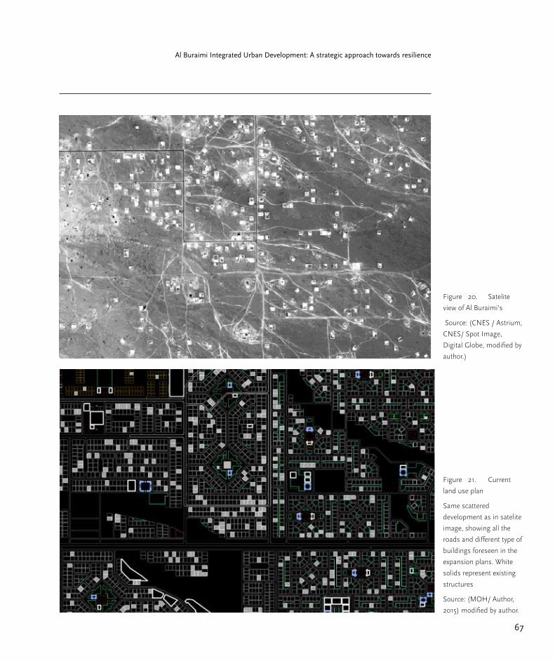
67
Al Buraimi Integrated Urban Development: A strategic approach towards resilience
Figure 20. Satelite
view of Al Buraimi’s
Source: (CNES / Astrium,
CNES/ Spot Image,
Digital Globe, modified by
author.)
Figure 21. Current
land use plan
Same scattered
development as in satelite
image, showing all the
roads and different type of
buildings foreseen in the
expansion plans. White
solids represent existing
structures
Source: (MOH/ Author,
2015) modified by author.

68
Part 2.1 Regional Development and Growth Management
There are two reasons why this happened: the
land allocation policy, and the large amounts of
plots destined for governmental offices when
Al Buraimi was made a Governorate in 2006.
These plots account for a big proportion of land,
spreading out new residential areas farther into
the west, where not much has been built yet.
The villages
The villages such as Mahda, Sunainah or Hafeet
have similar spatial structures. Many plots
in the villages are larger as many of them are
functioning as agricultural lands with houses
built inside. This older land pattern is mixed with
the land allocation policy where smaller plots,
nonetheless between 400-900m2 big, have
been allocated for the construction of housing.
These new plots are nearer to the highways that
link the towns and villages to bigger cities e.g..:
Al Buraimi, Ibris, Nizwa.
One of the striking features of Hafeet or As
Sunainah is the fact that spatial structures are
not as scattered as in the city of Al Buraimi. In
the villages a better, denser and more compact
structure seems to have prevailed. This is due
to the fact that most land allocated has been
inside the city of Al Buraimi, and not the villages,
and also because population growth in the
villages has remained either constant or slightly
decreasing.
Strikingly, both Hafeet and As Sunainah have
heritage values that are not being taken care of.
In Hafeet, the Ministry of Heritage has identified
many pre-historic graves but they remain
unknown to most Omanis, as well as their is
not a profit being acquired from their historic
potential.
Regional and common problematic
Omani lifestyle is becoming more and more
resource dependant; consequence of having
wealth from the petrol sector and imported
labour. This lifestyle is portrayed by the
simplicity which Omanis can build houses that
are detached from any urban tissue, because
there is always the possibility of commuting via
private vehicles.
The setting of areas for strategic
development and growth management
The analysis shows that Al Buraimi has the
means to provide subsidized resources and
services on an almost individual basis, such as:
water, electricity, etc.; but these living conditions
are getting farther away from what a city and
region should pursue in terms of resilient
development.
The need to supply individual services for
each household has negative economic
consequences. Nonetheless, the principal
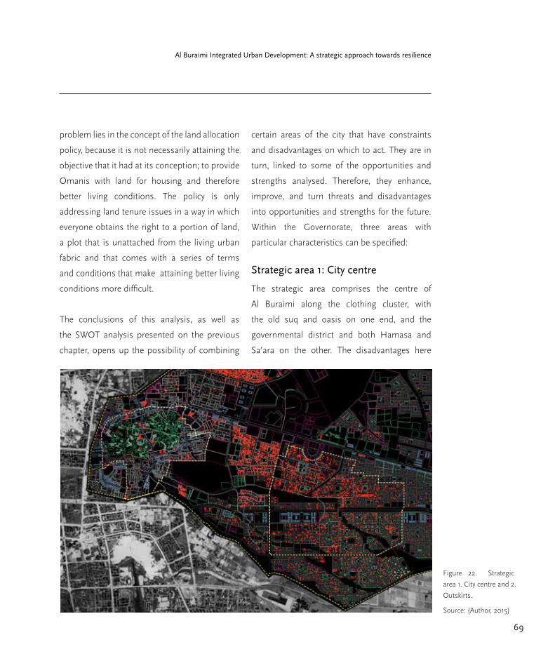
69
Al Buraimi Integrated Urban Development: A strategic approach towards resilience
problem lies in the concept of the land allocation
policy, because it is not necessarily attaining the
objective that it had at its conception; to provide
Omanis with land for housing and therefore
better living conditions. The policy is only
addressing land tenure issues in a way in which
everyone obtains the right to a portion of land,
a plot that is unattached from the living urban
fabric and that comes with a series of terms
and conditions that make attaining better living
conditions more difficult.
The conclusions of this analysis, as well as
the SWOT analysis presented on the previous
chapter, opens up the possibility of combining
certain areas of the city that have constraints
and disadvantages on which to act. They are in
turn, linked to some of the opportunities and
strengths analysed. Therefore, they enhance,
improve, and turn threats and disadvantages
into opportunities and strengths for the future.
Within the Governorate, three areas with
particular characteristics can be specified:
Strategic area 1: City centre
The strategic area comprises the centre of
Al Buraimi along the clothing cluster, with
the old suq and oasis on one end, and the
governmental district and both Hamasa and
Sa’ara on the other. The disadvantages here
Figure 22. Strategic
area 1. City centre and 2.
Outskirts.
Source: (Author, 2015)

70
Part 2.1 Regional Development and Growth Management
are related to the abandonment of agricultural
land, and congestion due to work places and
car ownership. But it also represents one of the
lively areas of the city, with plenty of work places,
combined with commerce and residential areas,
highger density and smaller commuting times.
Strategic area 2: The outskirts
The outskirts of the city or the area where
scattered development is the least dense. Where
housing units are located far away from one
another and the service of public infrastructure
is scarce. Here, the consequences of the type of
spatial development are the most striking. Most
of the issues analysed in the SWOT are present
in this area.
Strategic area 3: As Sunainah
Land is on the verge of being abandoned for
better opportunities in the city, and the public
facilities such as markets, schools, and places
of work are scarce. Future scattered housing
and growth are also a threat to the small rural
structures of the villages, thus here another
set of criteria towards strategic development
can be made. In order to produce a set of
Figure 23. Strategic
area 2. As Sunainah
Source: (Author, 2015)

71
Al Buraimi Integrated Urban Development: A strategic approach towards resilience
recommendations and finally a set of criteria
for the development of these 3 strategic areas,
a policy and instrument review regarding urban
growth management has to be presented; as
well as the specific instruments and policies
reviewed have to be contextualized.
Instrument and policy analysis for
Al Buraimi Governorate’s regional
growth management
In the following section the main tools and
instruments that are used to manage urban
growth and its pertinence to the context of Al
Buraimi are explained. Also, a conclusion that
will shed light on the establishment of a set of
criteria for further urban growth is presented.
This chapter describes briefly the general
situation of the three strategic areas, taking
into account that all of the urban issues are
already discussed and described in the SWOT
analysis, and then mentions which of the urban
growth management instruments are the most
pertinent to each area. Graphic images are
presented for each of the three strategic areas,
that portray an example of how could these
instruments be framed at an urban and rural
scale. In other words, this study identifies all the
potential places where the set of instruments
can be implemented within the strategic areas
and thus presents it in the shape of maps.
Box 12. Basic considerations for
the instruments
All of the options that are proposed here
are valid instruments for the city of Al
Buraimi and the villages, framed within
three strategic areas. Nonetheless it is
the responsibility of the policy maker
to decide which one of these options
suits the citizens better, and to decide
through consensus, with the municipal
authorities, on which ones to develop
further and finally implement. The
main objectives to have in mind when
choosing these instruments are to know
the direction, quality and pace of growth
that Al Buraimi wants.

72
Part 2.1 Regional Development and Growth Management
The city centre of Al Buraimi
The main problems analysed include plots that
are left unused, development mainly along the
highway, lack of quality and quantity of places
for gathering, increasing congestion in the main
avenues, etc. This is why a set of instruments
can be very rewarding in terms of making plots
more attractive for development, improving the
quality of urban fabric by starting “punctual”
renewal projects, regulating the sprawl of
certain commerce or office space in some areas,
as well as fostering the growth of it in others.
The instrument that identifies “areas with
urban potential use” can tackle this. Likewise,
this area is attractive for new constructions,
therefore regulatory instruments can play a
big role here, promoting the construction of
projects according to a new set of sustainable
criteria. Additionally, the municipality should
offer the opportunity for mixed use buildings to
appear along certain areas, as well as for new
architectural typologies to be tested.
There are many empty plots that need be to be
made more attractive by allowing new typologies
and uses to exist. This is why the mix-use,
building regulations, district specialization and
Figure 24. Strategic
area 1. City centre satelite
image
Highest density and most
diverse plot use in city
centre
Source: (CNES / Astrium,
CNES/ Spot Image,
Digital Globe, modified by
author., 2014)

73
Al Buraimi Integrated Urban Development: A strategic approach towards resilience
Existing building
Un-built plot
Existing street
Un-built street
New building regulations and typologies
Mixed-use
Specialized commercial district
Plots with urban design potential and connectivity
Adequate Public Facility Ordinances
Specialized agriculture district
Short time allowed for plots to develop
Medium time allowed for plots to develop
Extenden time allowed for plots to develop
Figure 25. Strategic
area 1. City centre: Urban
growth management
instruments
Source: (Author, 2015)
urban design potential instruments are relevant
for this strategic area. In the short term, it is
expected to see new projects come in the way
of the current urban fabric, but slowly a change
in paradigm is expected to occur, when citizens
have the chance to experience the benefits of
better urban conditions. They are expected
to occur in many ways: less commuting to
places of leisure, worship, commerce, study;
better building conditions and reduced costs
in electricity for air conditioning; better urban
space after urban interventions occur; and
lastly a thriving district with commerce, culture,
habitation and office space condensed in a
better and optimal way.

74
Part 2.1 Regional Development and Growth Management
The main instrument for this to occur in the long
term will be the time allowed for plots to develop.
If made possible, plot owners that don’t have
any intention to develop the land, can be offered
another plot in an area that is not affected by this
policy. Bids for projects in available plots within
the time frame policy can then be reviewed by
the authorities and then choose the projects that
fulfil the new development criteria proposed by
this study. The time frame considered for this
policy is the following: short term developments
are proposed as lasting 2 years; a medium term
5 years, and a longer term 10 years. This is why
this instrument will start transforming the city in
the mid- and long-term.
The real shift in paradigm will occur when land
in the city centre of Al Buraimi becomes more
attractive for projects to be built.
The Municipality should always keep in mind
that when making decision over a set of projects
for a given plot, the project that ensures the best
use of sustainable construction methods, and
that ensures better urban quality for its users
and its surroundings, should always be chosen,
Regarding APFOs in the city centre, new projects
that want to be developed here will have to pay a
higher price than the projects that are developed
in city areas where the distribution of services is
still not existent.
Figure 26. Strategic
area 1. City centre:
Specialized clothing
cluster
Source: (Author, 2015)
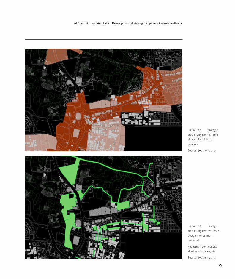
75
Al Buraimi Integrated Urban Development: A strategic approach towards resilience
Figure 27. Strategic
area 1. City centre: Urban
design intervention
potential
Pedestrian connectivity,
shadowed spaces, etc.
Source: (Author, 2015)
Figure 28. Strategic
area 1. City centre: Time
allowed for plots to
develop
Source: (Author, 2015)
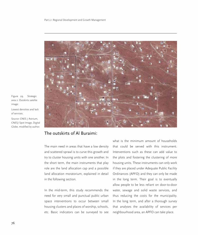
76
Part 2.1 Regional Development and Growth Management
The outskirts of Al Buraimi:
The main need in areas that have a low density
and scattered sprawl is to curve this growth and
try to cluster housing units with one another. In
the short term, the main instruments that play
role are the land allocation cap and a possible
land allocation moratorium, explained in detail
in the following section.
In the mid-term, this study recommends the
need for very small and punctual public urban
space interventions to occur between small
housing clusters and places of worship, schools,
etc. Basic indicators can be surveyed to see
what is the minimum amount of households
that could be served with this instrument.
Interventions such as these can add value to
the plots and fostering the clustering of more
housing units. These instruments can only work
if they are placed under Adequate Public Facility
Ordinances (APFO) and they can only be made
in the long term. Their goal is to eventually
allow people to be less reliant on door-to-door
water, sewage and solid waste services, and
thus reducing the costs for the municipality.
In the long term, and after a thorough survey
that analyses the availability of services per
neighbourhood area, an APFO can take place.
Figure 29. Strategic
area 2. Outskirts satelite
image:
Lowest densities and lack
of services.
Source: CNES / Astrium,
CNES/ Spot Image, Digital
Globe, modified by author.

77
Al Buraimi Integrated Urban Development: A strategic approach towards resilience
This instrument can transform the scattered
areas of Al Buraimi in the long term, because
after the APFO are functioning, development
that takes place outside the designated areas
will have to pay for the adequate fees necessary
for the provision of services in new areas.
Frequently, extra fees will induce developers and
construction to occur within the APFOs.
The designation of mixed use areas and the
fostering of new typologies will play a secondary
role in this strategic area.
Figure 30. Strategic
area 2. Outskirts: Urban
growth management
instruments
Source: (Author, 2015)
Existing building
Un-built plot
Existing street
Un-built street
New building regulations and typologies
Mixed-use
Specialized commercial district
Plots with urban design potential and connectivity
Adequate Public Facility Ordinances
Specialized agriculture district
Short time allowed for plots to develop
Medium time allowed for plots to develop
Extenden time allowed for plots to develop

78
Part 2.1 Regional Development and Growth Management
Figure 31. Strategic
area 2. Outskirts: New
typology implementation
Source: (Author, 2015)
Figure 32. Strategic
area 2. Outskirts: Urban
design intervention
potential:
pedestrian connectivity,
shadowed spaces, etc.
Source: (Author, 2015)
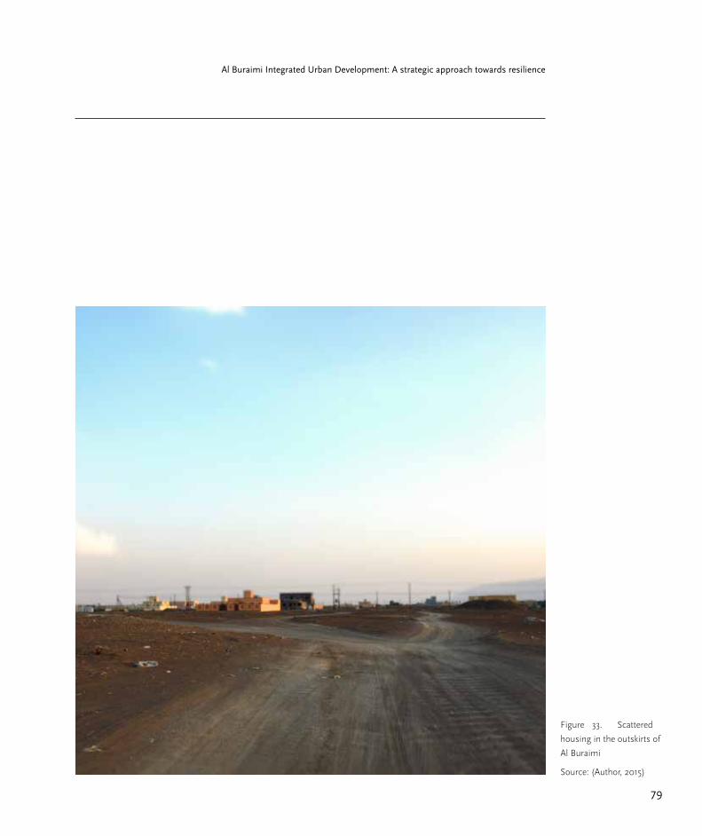
79
Al Buraimi Integrated Urban Development: A strategic approach towards resilience
Figure 33. Scattered
housing in the outskirts of
Al Buraimi
Source: (Author, 2015)
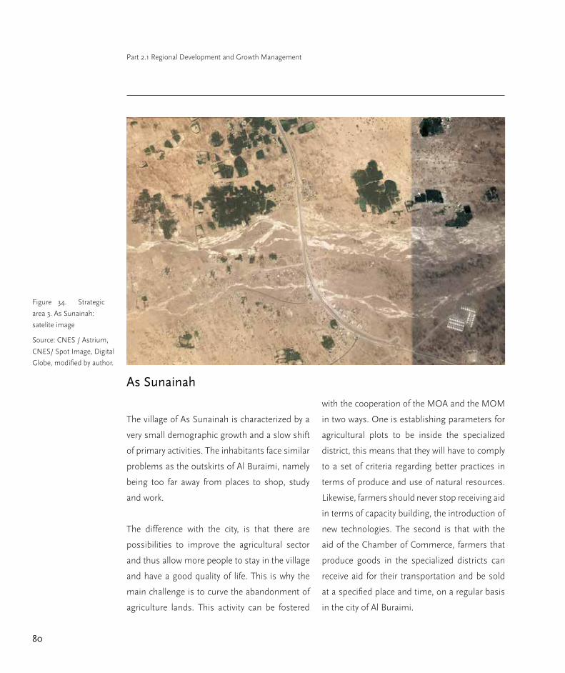
80
Part 2.1 Regional Development and Growth Management
As Sunainah
The village of As Sunainah is characterized by a
very small demographic growth and a slow shift
of primary activities. The inhabitants face similar
problems as the outskirts of Al Buraimi, namely
being too far away from places to shop, study
and work.
The difference with the city, is that there are
possibilities to improve the agricultural sector
and thus allow more people to stay in the village
and have a good quality of life. This is why the
main challenge is to curve the abandonment of
agriculture lands. This activity can be fostered
with the cooperation of the MOA and the MOM
in two ways. One is establishing parameters for
agricultural plots to be inside the specialized
district, this means that they will have to comply
to a set of criteria regarding better practices in
terms of produce and use of natural resources.
Likewise, farmers should never stop receiving aid
in terms of capacity building, the introduction of
new technologies. The second is that with the
aid of the Chamber of Commerce, farmers that
produce goods in the specialized districts can
receive aid for their transportation and be sold
at a specified place and time, on a regular basis
in the city of Al Buraimi.
Figure 34. Strategic
area 3. As Sunainah:
satelite image
Source: CNES / Astrium,
CNES/ Spot Image, Digital
Globe, modified by author.

81
Al Buraimi Integrated Urban Development: A strategic approach towards resilience
Small scale urban interventions are also
reccomended, mainly to promote connectivity
between plots and places of study, leisure and
worship. This can help in promoting a stronger
community, which will always be useful if most
of the inhabitants are dealing with the same
economic activity.
In the long term, the municipality should focus
on providing adequate services and facilities.
Likewise, the Municipality should prevent the
settling of new scattered neighbourhoods with
the creation of APFO, so that new development
outside of it will also bear the infrastructure
implementation charges.
Figure 35. Strategic
area 3. As Sunainah: urban
growth management
instruments
Source: (Author, 2015)
Existing building
Un-built plot
Existing street
Un-built street
New building regulations and typologies
Mixed-use
Specialized commercial district
Plots with urban design potential and connectivity
Adequate Public Facility Ordinances
Specialized agriculture district
Short time allowed for plots to develop
Medium time allowed for plots to develop
Extenden time allowed for plots to develop

82
Part 2.1 Regional Development and Growth Management
Selected instruments for urban
growth management
Short-term
The following selected instruments can take
place as soon as possible in order to gain time
for the mid- and long-term instruments to be
defined. They can be implemented during the
first two years of the implementation of the
whole set.
Development moratorium and land
allocation cap
One of the most drastic approaches available
is a development moratorium. The distribution
of plots further away from the centre of Al
Buraimi should be paused; likewise for the
villages. A moratorium for this policy is difficult
to implement, but can buy time, which is much
needed for the next instruments to be developed
properly. Parallel to this policy, the Ministry of
Housing needs to establish a development cap
that can decide on the pace that the city wants
to have regarding number of plots allocated
within each new period. This development cap
can be promoted as a way to give only optimal
land for development and not to continue giving
away land far away from the strategic areas
and infrastructure expansion plans. The land
allocation cap can be regarded as a short-term
instrument as it does not solve the issues related
to urban growth in the long term. Nonetheless it
should be maintained, reviewed and monitored
in order to define if the cap should allow more
plots, or constrain more plots in the future.
Middle term
In the mid-term there are many instruments that
can start to be designed. They can be divided
into two different categories: incentive type and
control type instruments. The mid-term for the
instruments to work is defined by a time frame
starting at 2 years until 10 years.
In the case of the incentive instruments, it is
important to promote the land market of plots
that are located in these centres. Additionally,
control type instruments will prevent bad
practices from continuing and gradually shift
towards a resilient and sustainable growth
paradigm.
New typology implementation
Varied uses can be allowed to appear in the city.
They can combine housing with commercial
and office space; what typically is a mix-used
typology. Even though this typology exists in
some parts of the city, there is a potential in
designing a very novel and contextualised
typology that caters to both the needs of a
growing population, authorities, and fosters
83
Al Buraimi Integrated Urban Development: A strategic approach towards resilience
better urban development. Here is where
the instrument plays a major role in a shift of
paradigm; as it has to offer the opportunity for
new typologies to be created. The typologies are
not going to be defined in this study, as it is not
in the scope. Nonetheless, this study claims
that if mixed uses are promoted via the waiving
or exemptions of taxes, or even through low
interest loans for the projects that go along this
development direction; then slowly but certainly
the areas around the strategic centres will start
to change. The Municipalities role in the matter
is to make sure that this novel typologies are
promoted and fostered.
Additionally regarding a new typology, an
increase in heights is important. An average
height of 5 or 6 storeys should be pursued as is
already evident with some of the buildings in the
centre . Single storey or two storey projects have
to be discouraged in the city centre.
Building standards:
Better building materials should include
construction materials that are produced
nearby, insulate better against the extreme
temperatures and thus allow savings in cooling
and electricity. Additionally better technologies
in the construction industry and for building
installations (e.g.: solar energy production
on a household scale for both production
of electricity and water heating) should be
supported. Likewise, the surface of windows in
buildings and quality of glass has to be carefully
reviewed so that buildings are better insulated.
Urban design interventions:
There should be small-scale urban public
space interventions, that can create adequate
shaded spaces in clustered neighbourhoods.
This is thought in order to promote the use of
endemic tree species, grey water use for their
maintenance, and the creation of connectivity
between neighbourhoods in a small scale. This
instrument is represented in the figures as a
large amount of space with the potential to be
transformed. This should be seen as an identifier
of such space and not as an urban design tool
that directs where and how this intervention
should occur.
The role of the Municipality is to identify the best
small plots and spatial remnants between them,
to start up a project that generates better public
urban space, in both Al Buraimi and the villages.
Time allowed for plots to develop:
There has to be a shift in the way in which
land is allocated without any responsibility for
development. It is understandable that the
Municipality cannot impose new regulations
on a national policy, but they can also provide

84
Part 2.1 Regional Development and Growth Management
new incentives for the owners who do develop
their plots in a determined time frame. This
will give another boost for the people who do
have the means and desire to develop plots, and
will diminish the amounts of plots that remain
undeveloped and unused. This scarred urban
tissue should be prevented as much as possible.
Likewise, plots that remain undeveloped should
be taxed in a very careful way, meaning that a set
of criteria for what a “developed plot” is, should
be established first. Another alternative is that
taxation for unused plots is implemented, and
it can be higher in city centre plots than in
peripheral plots.
If the creation of a fee for plots that are not
being used is not attractive for the Municipality,
this study also proposes that plots only be
allowed to remain unused for a maximum time
period. After which they should be transferred
to other users with proposals for them. In
this scenario, the original owner should get
another plot allocated in an area of the city
where this specific instrument is not in play.
This instrument considers three phases: by
short time to develop a plot (up to 2 years),
medium time (up to 5 years), and a maximum
of 10 years for extended time. Plots outside the
area designated by this instrument will have a
standard tenure. It is important to stress the
need for a set of criteria that can determine if a
plot is actually being developed and used, or if it
is genuinely abandoned.
Urban design control measures:
New projects should provide some open space
but always at the backside of the plots; these
areas are the ones that eventually can be used
for car parking. They should never be on the
front side of the street as it normally occurs;
conditions and specifications for car parking
spaces have to be reviewed and changed. This
also means that alignment regulations have
to be carefully reviewed by the corresponding
Ministries, namely MOH and MOM.
This instrument is not necessarily a growth
instrument but it is one that this study identifies
as necessary to complement and guide the
previous ones.
Tighter building regulations
Urban growth should be encouraged but
always within a new set of criteria, the following
instrument is also a counterpart of the incentive
type regulations, as it will discourage some
development to occur, but will foster more
sustainable projects taking place.
The gradual setting of regulations that
discourage bad practices in terms of materials
and renewable energy for housing, commerce

85
Al Buraimi Integrated Urban Development: A strategic approach towards resilience
and industry, include a more expensive building
permit for any project that does not consider the
new building standards.
This way, the waivers and tax exemptions for
the projects that are built accordingly to the
new standards can be financed by the projects
that are not. This type of instrument cannot be
applied to the already built projects in the city,
but the incentives should be available for them in
the case of refurbishment, retrofitting, building
extensions, etc. Eventually, these standards can
be turned into regulations so that all projects
comply them.
Long-term measures
The following long-term measures can be put
in place after two or three years of the first
implementation of instruments, but they will
be able to show benefits after the fifth year of
its implementation and can be elongated as
necessary as possible.
District specialization
A link between the agriculture producers of
the region and the market vendor could be
established, through the promotion of space and
financial aid for such market process to occur. It
is important to bear in mind that any investment
in this type of subsidiarity means that the region
can become more resilient towards certain
issues. Agriculture should also be fostered with
better technologies and practices in order to
have more efficient water management.
Clusters of commerce should be encouraged
further. Incentives in certain areas can be
exclusively for commerce dedicated to the
clothing industry for example; or for retail, offices,
etc. This can also make small neighbourhoods
attractive as well as social capital is encouraged
through a public policy.
APFO’s
Adequate Public Facilities Ordinances (APFO)
can help in creating an environment for the
right implementation of development projects.
A thorough study that can provide the right
indicators for the number of plots of each
type in different areas; namely the strategic
development areas and the outer parts of the
city, has to be made. Demographical surveys
need to occur in order to do this properly. Data
needed includes detailed demographical growth
per area in the Governorate.
Combined with the MOH and the MOM
development plans, a set of APFO has to be
implemented to direct further growth in the
long term. This will change the land market in Al
Buraimi drastically, but in the long term, urban
growth will be directed towards more specific

86
Part 2.1 Regional Development and Growth Management
goals, instead of uncontrolled results derived
from master planning. APFO can include the
amount of households in areas that are already
served by public sewage and waste-management
networks, as well as areas that are served by the
water network. This will make it unattractive for
developers to build outside of the areas that are
not going to be served with adequate public
facilities yet.
This instrument can also be applied to the
areas where urban development is highly
scattered. There can be an APFO that promotes
the clustering of living units in the same
area in order to receive basic infrastructure.
This strategy could foster that plots that are
scattered and undeveloped acquire different
values according to the possibility of clustering
together. Also, people can be encouraged to
organize themselves in a community of clusters,
in order to have sets of houses developed in
a certain area. The goal would be to cluster
development as much as possible in order
for the basic services to be provided by the
municipality in the future, and cut costs in water
distribution, or wastewater and solid waste
management.
A survey will be needed to obtain the necessary
indicators for an APFO to take place; done by
MOM, MOH, MOA and MOTC.
Building standards in the long-term
If a new code of building regulations for the
Governorate of Al Buraimi is done, then in the
long term it will be possible to stop projects
that don’t take advantage of renewable energy
resources, or thermic insulation for example.
Incentives can be paired with fees so that in
the long term there is always a reason to build
accordingly to new standards. Rural areas in
Al Buraimi could benefit greatly from such
measures, if ever in the long term the capacity
of ground water is even scarcer, it will be of
much help if the urban areas manage their water
consumption in a better way.
Action plan for regional
development through growth
management
The adjacent table shows the selected
instruments and differentiates them briefly
by type, name, short description, authority in
charge and measures needed for the instrument
to be implemented in the appropriate time
frame.

87
Al Buraimi Integrated Urban Development: A strategic approach towards resilience
Type Name Brief descriptionAuthority in charge Measures needed
controlDevelopment moratorium
Short pause needed to plan carefully the implementation of the next instruments
MOMTemporary halt in land allocation process.
controlLand allocation cap
Restrict the number of plots that get laidout and distributed in the next stages
MOM + MOHAnalysis of maximum number of appropriate plots that can be allocated per term.
incentiveNew typology implementation
New mixed use typologies, increase in heights, setbacks, building standards
MOM Building permit incentives.
incentiveNew building standards
Better and adequate building materials, technologies and practices according to criteria
MOM+MOHBuilding code with new incentives.
regulationNew building standards
Regulation of un-built space in plots; tighter regulations favouring urban design and pedestrian friendly setbacks; deprioritize parking lots, and prioritize mixed use street level.
MOM+MOHBuilding code regulations and penalties, controlled by building permits.
controlTime allowed for plots to develop
Plots allocated in certain areas have a time frame for a project to be developed there. Failure to comply with a project leads to the plot being re-allocated. Original owner gets a new plot in an area without a time frame.
MOM
Temporary ownership of allocated plot until project is aproved, as well as a new re-allocation scheme is needed.
designUrban design interventions
Foster the creation of shadowed public spaces that allow connectivity, with the use of endemic species and greywater.
MOM+MOTCSurvey to identify the initial small scale projects, and a call for proposals.
incentiveDistrict specialization
Foster and facilitate the creation of certain enterprise and economic activities.
MOA+COC
Waivers and financial contributions for startups, commercialization of goods from farms into the city, as well as capacity building and better technology.
control APFO
Provision of services from municipality based on a long term plan according to clustering of built units and denser development
MOT+MOM+MOH
Survey and studies needed in order to specify which areas will the APFO cover.
regulationBuilding standards
Gradually implement obligatory building standards in order to stop incentives for good practices and only continue with penalties for un-wanted building practices.
MOM+MOH Building permit regulation.
regulationResource management standards
Better wastewater reuse, solid waste management, and sustainable energy use
MOM+MOH+MOA
Incentives for projects that take advantage on sustainable technology as well as higher building permit costs for projects that do not.
Short term
Mid term
Long term
Urban growth management instruments and necessary procedures in time phases for AL Buraimi Governorate
Figure 36. Action plan
for growth management
Source: Author, 2015

88
Part 2.1 Regional Development and Growth Management
Flexibility and adaptation of
instruments in the mid and long-term
The main thing to have in mind regarding
these sets of instruments, is the fact that they
are not permanent and static, but flexible and
adjustable. This means that in the medium term,
instruments that rely on specific boundaries
have to be small-scale and site specific.
With the use of monitoring, the urban
management growth instruments can adapt to
the growing conditions of the city and villages,
and thus go along development in a periodical
and careful way. These instruments should
never be regarded as master planning or zoning
measures, but as directive, preventive and
repelling measures for identified urban growth
patterns.
Alternatives and complications for this
set of instruments
First of all, for the short term instruments,
an allocation cap will be unpopular for the
future generations that are waiting for plots.
The negative implications of this instrument
should be regarded in the following terms: the
municipality should not only allocate plots,
but also ensure that plots allocated can lead
to better living conditions. This means that
the municipality has the responsibility from
stopping the distribution of plots that hinder
development and can leave people without
adequate infrastructure and services, as well
as potential bad living conditions in the long
term. The consequences of scattered urbanism
explained earlier should always be kept on mind.
Regarding the mid-term instruments, there is a
possibility that the citizenry is reluctant to new
typologies. The introduction of this novel type of
building regulations will be slow to be adopted
from the demand side. Nonetheless, the policy
makers have to make sure that the possibility
for this type of development is there, namely
through the creation and implementation of new
sets of regulations that allow such a typology to
establish.
The Municipality has to keep in mind that
long terms measures are intended for the well-
being of the vast majority as well as for the
environment; therefore new enterprises that
want to be involved in the production of more
adequate building materials and solar energy
technology have to be considered in the further
development of Al Buraimi.

89
Al Buraimi Integrated Urban Development: A strategic approach towards resilience
Conclusions
Al Buraimi can lead the way towards a more
resilient society in economic, social and
environmental terms. It is recognized that
“governments must implement policies to
ensure that the benefits of urban growth
are shared equitably and sustainably” (UN
Department of Economic and Social Affairs,
2014). Likewise, a resilient development
implies that the city creates better employment
opportunities as well as an improved resource
and waste management, in addition to
transportation, equality and governance.
In the long-term, the living conditions can be
enhanced if the shift in the current development
paradigm occurs. This implies that management
of services are improved, better land tenure
opportunities as well as housing conditions are
ensured, reducing living costs for the people
and the municipality. Likewise, better spatial
qualities can be ensured if a typological shift
occurs, where the cities condense and provide
more spaces for encounter, leisure, worship,
study and employment. This is what is meant by
a shift in paradigm in the criteria that drives the
development of Omani cities.
Figure 37. View of
Al Buraimi‘s scattered
urbanism
Growth continues to
extend farther and farther
away into the city limits.
Source: (Author, 2014)

90
Part 2.1 Regional Development and Growth Management
References
Abdel-Rahman, H. A. & Abdel-Magid, I. M.
(1993) Water Conservation in Oman. Water
International.18 (2), 95–102.
Abdel Rahmnn, H. A. & Omezzine, A. (1996) Aflaj
Water Resources Management: Tradable Water
Rights to Improve Irrigation Productivity in Oman.
Water International. 21 (2), 70–75.
Alterman, R. & MacRae, D. (1983) Planning and
Policy Analysis Converging or Diverging Trends?
Journal of the American Planning Association. 49
(2), 200–215.
Anis, U. R. & Ali Fadaak, T. (1991) New towns
in Saudi Arabia. Habitat International. 15 (1/2),
167–179.
Al-Awadhi, T. (2007) ‘Monitoring and modeling
urban expansion using GIS & RS: Case study from
Muscat, Oman’, in Urban Remote Sensing Joint
Event, 2007. 2007 IEEE. pp. 1–5.. Available from:
Al-Badi, A. et al. (2009) Power sector of Oman—
Today and tomorrow. Renewable and Sustainable
Energy Reviews. 13 (8), 2192–2196.
Al-Badi, A. H. et al. (2009) Assessment of
renewable energy resources potential in Oman
and identification of barrier to their significant
utilization. Renewable and Sustainable Energy
Reviews. 13 (9), 2734–2739.
Al-Badi, A. H. et al. (2011) Sustainable energy
usage in Oman—Opportunities and barriers.
Renewable and Sustainable Energy Reviews. 15
(8), 3780–3788.
Baptista e Silva, J. et al. (2012) Paying as the urban
areas grow – implementing and managing urban
development charges using a GIS application.
International Journal of Geographical Information
Science. 26 (9), 1689–1705.
Bengston, D. N. et al. (2004) Public policies for
managing urban growth and protecting open
space: policy instruments and lessons learned in
the United States. Landscape and Urban Planning.
69 (2-3), 271–286.
Buerkert, A. et al. (2010) Oases of Oman:
livelihood systems at the crossroads. Muscat: Al
Roya Press & Pub. House.
Cities Alliance (2011) Guidebook for City
Development Strategies in Southern
Mediterranean Countries | Cities Alliance.
Cugurullo, F. (2013) How to Build a Sandcastle:
An Analysis of the Genesis and Development of
Masdar City. Journal of Urban Technology. 20 (1),
23–37.

91
Al Buraimi Integrated Urban Development: A strategic approach towards resilience
Cumbers, A. & Mackinnon, D. (2004)
Introduction: clusters in urban and regional
development. Urban Studies. 41 (5-6), 959–969.
Daghistani, A.-M. (1991) Urban growth
management in Jeddah. Journal of Environmental
Planning and Management. 34 (1), 2–9.
Davoudi, S. et al. (2012) Resilience: A Bridging
Concept or a Dead End? ‘Reframing’ Resilience:
Challenges for Planning Theory and Practice
Interacting Traps: Resilience Assessment of
a Pasture Management System in Northern
Afghanistan Urban Resilience: What Does it
Mean in Planning Practice? Resilience as a Useful
Concept for Climate Change Adaptation? The
Politics of Resilience for Planning: A Cautionary
Note: Edited by Simin Davoudi and Libby Porter.
Planning Theory & Practice.
Din, M. A. E. (1990) The transport importance of
the Arabian (Persian) Gulf. Transport Reviews. 10
(2), 127–148.
Dutton, R. W. (1983) Handicrafts in Oman and
their role in rural community development.
Geoforum. 14 (3), 341–352.
Fibiger, T. (2014) Heritage erasure and heritage
transformation: how heritage is created by
destruction in Bahrain. International Journal of
Heritage Studies. 1–15.
Fox, J. W. et al. (2006) Globalization and the
Gulf. Auflage: New. London; New York: Routledge
Chapman & Hall.
Frenkel, A. & Orenstein, D. E. (2012) Can Urban
Growth Management Work in an Era of Political
and Economic Change? International Lessons
From Israel. Journal of the American Planning
Association. 78 (1), 16–33.
Gangler, A. (2008) Oases settlements in Oman.
Stuttgart: Edition Esefeld & Traub.
Gangler, A. & Gaube, H. (2012) Transformation
Processes in Oasis Settlements of Oman. Al Roya
Press.
Gani, A. & Al Mawali, N. R. (2013) Oman’s trade
and opportunities of integration with the Asian
economies. Economic Modelling. 31766–774.
Glaeser, E. L. et al. (2014) Cities, Skills and
Regional Change. Regional Studies. 48 (1), 7–43.
Halper, E. B. et al. (2015) Effects of irrigated parks
on outdoor residential water use in a semi-arid
city. Landscape and Urban Planning. 134210–220.
Ben-Hamouche, M. (2013) The paradox of
urban preservation: balancing permanence and
changeability in old Muslim cities. Journal of
Urbanism: International Research on Placemaking
92
Part 2.1 Regional Development and Growth Management
and Urban Sustainability. 6 (2), 192–212.
Janzen, J. (1983) The modern development of
nomadic living space in Southeast Arabia—the
case of Dhofar, Sultanate of Oman, Geoforum. 14
(3), 289–309.
Krasnowiecki, J. & Strong, A. L. (1963)
Compensable Regulations for Open Space: A
Means of Controlling Urban Growth. Journal of
the American Institute of Planners. 29 (2), 87–97.
Leach, M. (2008) Re-framing resilience:
trans-disciplinarity, reflexivity and progressive
sustainability–a symposium report.
Locke, C. M. & Rissman, A. R. (2015) Factors
influencing zoning ordinance adoption in rural
and exurban townships. Landscape and Urban
Planning. 134167–176.
Looney, R. E. (1990) Reducing dependence
through investment in human capital: An
assessment of Oman’s development strategy.
Socio-Economic Planning Sciences. 24 (1), 65–75.
Mahgoub, Y. (2007) Architecture and the
expression of cultural identity in Kuwait. The
Journal of Architecture. 12 (2), 165–182.
Majid, N. H. A. et al. (2012) Vernacular Wisdom:
The Basis of Formulating Compatible Living
Environment in Oman. Procedia- Social and
Behavioral Sciences. 68637–648.
Mohammad, R. & Sidaway, J. D. (2012)
Spectacular Urbanization amidst Variegated
Geographies of Globalization: Learning from
Abu Dhabi’s Trajectory through the Lives of
South Asian Men: Abu Dhabi’s urbanization
trajectory from the perspective of South Asian
men. International Journal of Urban and Regional
Research. 36 (3), 606–627.
Morton, M. Q. (2013) Buraimi: The Struggle for
Power, Influence and Oil in Arabia. London ; New
York: I. B. Tauris.
Onsman, A. (2011) It is better to light a candle
than to ban the darkness: government led
academic development in Saudi Arabian
universities. Higher Education. 62 (4), 519–532.
Petersen, A. (2009) ‘Islamic urbanism in eastern
Arabia: the case of the al-ʾAyn-al-Buraymī oasis’,
in Proceedings of the Seminar for Arabian
Studies. Papers from the forty-second meeting of
the Seminar for Arabian Studies held in London.
London: Archaeopress. pp. 307–320.
Phillips, W. (1972) Unknown Oman. Intl Book
Centre.
Porter, D. R. (1997) Managing Growth in
America’s Communities. Island Press.

93
Al Buraimi Integrated Urban Development: A strategic approach towards resilience
Porter, M. E. (1994) The Role of Location
in Competition. International Journal of the
Economics of Business. 1 (1), 35–40.
Prathapar, S. A. et al. (2005) Overcoming
constraints in treated greywater reuse in Oman.
Desalination. 186 (1-3), 177–186.
Royal Oman Police & Ministry of Health (2012a)
Oman Statistics Housing.
Saines, N. (1986) ENHG Committee Abu Dhabi
Bulletin: History of the Buraimi Oasis.
Siebert, S. et al. (2005) Agricultural, architectural
and archaeological evidence for the role and
ecological adaptation of a scattered mountain
oasis in Oman. Journal of Arid Environments. 62
(1), 177–197.
Singh, S. B. (1996) New Perspectives in Urban
Geography. M.D. Publications Pvt. Ltd.
Speece, M. (1989) Aspects of Economic Dualism
in Oman 1830–1930. International Journal of
Middle East Studies. 21 (04), 495–515.
Swanstron, T. (2008) ‘Regional Resilience: A
Critical Examination of the Ecological Framework’,
in 2008 Baltimore, Maryland, USA: MacArthur
Foundation Research Network on Building
Resilient Regions.
Thesiger, W. & Stewart, R. (2008) Arabian Sands.
Revised edition. London: Penguin Classics.
Ukayli, M. A. & Husain, T. (1988) Comparative
Evaluation Of Surface Water Availability,
Wastewater Reuse And Desalination In Saudi
Arabia. Water International. 13 (4), 218–225.
UN Habitat (2012) The relevance of street
patterns and public space in urban areas.
UNITED NATIONS & Department of Economic
and Social Affairs (2014) World urbanization
Prospects 2014. Population Studies. United
Nations Publications.
Wiedmann, F. et al. (2014) Sustainable urban
qualities in the emerging city of Doha. Journal of
Urbanism: International Research on Placemaking
and Urban Sustainability. 7 (1), 62–84.
Wiedmann, F. et al. (2012) Urban Evolution
Of The City Of Doha: An Investigation Into
The Impact Of Economic Transformations On
Urban Structures. Metu Journal of the Faculty of
Architecture.
Yagoub, M. M. (2004) Monitoring of urban
growth of a desert city through remote
sensing: Al-Ain, UAE, between 1976 and 2000.
International Journal of Remote Sensing. 25 (6),
1063–1076.

Part 2.2 Sustainable transportationPedro Becerra Rodríguez

The city of Al Buraimi, located in the northwest
of the Sultanate of Oman, has experienced
rapid urban growth characterized by patchy
and unsustainable development over the last
years. As a result of this process, the city is
facing challenges in different dimensions of
the urban structure. One of these problems is
transportation, which is automobile dependent
and road based. Additionally, Al Buraimi
presents segregated land use patterns, low
densities, reduced travel choices, considerable
occupation of land for car facilities and high
accidents rates, amongst other issues. Thus
the increasing transportation needs may lead to
social, environmental and economic problems.
Additionally, the transportation planning
process is characterized by a lack of coordination
among institutions and shortage of vision.
Car dependency can be attributed to different
factors; firstly, the national transportation
policy and legal framework are focused on
roads development. Secondly, prices of cars
and oil are relatively affordable in the Sultanate,
and there is a car culture based on foreign
automobile models. Furthermore, the current
strong top down approach does not facilitate
the instruments necessary to implement a
sustainable mode of transportation. A more
balanced transportation system, achieved via
a more holistically coordinated and inclusive
planning approach would provide many
benefits to the city. This chapter has the aim
of analyzing the current transportation system
in Al Buraimi. Afterwards, this study intends to
provide proposals which are based on criteria
and concepts to adapt toward a more balanced/
sustainable transportation system in Al Buraimi.

96
Part 2.2 Sustainable Transportation
Assessment of the current
state of transportation and
mobility
The affordable prices of oil and cars in addition
to the road based transportation policy of Oman,
has led to automobile dependency in Al Buraimi.
As a result, the vast majority of residents use
cars to travel. It is estimated that 90% of citizens
move by private car, whereas 5% travel by taxi,
which is the only complementary means of
transport available for the citizens. Furthermore,
2% of the residents travel by private bus; this
number only includes certain students and
workers, who use the service provided by their
schools and companies. Meanwhile, only 2%
and 1% of the residents commute by walking or
biking respectively. The information on choice of
transportation in Al Buraimi is illustrated in the
graph below.
Low costs for car based mobility
Considering indicators such as residents’
income per month and prices of cars and oil, it is
Choice of transportation
mode in Al Buraimi
Source: (Author, 2014
(based on community
questionnaires)
Previous page:
Main street in Al Buraimi
Source: (Salcedo, 2014)

97
Al Buraimi Integrated Urban Development: A strategic approach towards resilience
evident that private transportation in Al Buraimi
is affordable for residents. For instance, in the
automobiles’ market, new cars are available
from 500 Omani Rials. Additionally, prices of
fuel are very low due to the fact the Sultanate
of Oman is an oil producing country. The price
for one litre of oil is normally 0.12 O.R. (NCSI,
2014). Meanwhile, the average minimum wage
in Oman is 325 O.R. per month (Zawya, 2013).
Additionally, the costs of car insurances and
maintenance are not expensive.
High investment into improved road
network
Over the last 3 years, there has been a
considerable increase in road building in the
Governorate of Al Buraimi. This is attributed
to the urban growth of the city and new
infrastructure built for regional linkages.
According to the National Center of Statistics
and Information of Oman (2014), only 15
kilometers of roads were built in 2011. However,
in 2012 the road length increased sharply and 103
kilometers of new roads were laid. Afterwards,
113 kilometers of new roads were laid in 2013
in Al Buraimi. The total expenditure in roads
in Oman can provide an overall idea of the
economic costs attributed to the infrastructure
for road-based developments in the Sultanate.
According to the National Center for Statistics
and Information (2014), the Oman Government
Development Expenditure for roads was 384.9
Millions in O.R. in 2011. This expenditure
decreased slightly to 373.3 Millions of O.R. in
2012. Afterwards, it increased again and the cost
was 424.3 Millions of O.R. in 2013. Furthermore,
according to the Department of the Ministry of
Transport and Communications in Al Buraimi
(2014), the budget allocated for maintenance
of the highways and regional roads is 100.000
O.R. per year. Thereby, the information on road
expenditure shows a significant amount of the
development budget invested on car-based
transportation infrastructure.
Road-related transport services in Al
Buraimi
The few available services provided are private
transport such as taxis, school buses, and buses
for workers. The operation of taxis is controlled
and regulated by the Royal Oman Police. There
are no taxi companies in charge of the service
and there is no informal transport. Moreover, the
bus service for public schools is managed by the
local government. In contrast, the bus service
for private schools, Buraimi University, and
workers is managed directly by the educational
institutions or by the companies.

98
Part 2.2 Sustainable Transportation
Furthermore, the National Oman Transportation
Company provides public bus services to travel
from Al Buraimi to Sohar-Muscat and Ibri-Nizwa.
The NOTC is the only transportation company
in the Sultanate and operates throughout the
country. However, the service does not match
the demand of regional linkages in Al Buraimi.
Environmental impacts
According to the World Bank (2014), the
carbon dioxide emissions in Oman increased
significantly over a period of only 20 years,
measuring such emissions from 1990 to 2010.
The number of metric tons in 1990 was 6.3
per capita, which rose to 20.4 per capita by the
Figure 38. Built roads
in Al Buraimi
Road executed lengths
in the Governorate of Al
Buraimi per Year
Source: (National
Center of Statistics and
Information, 2014)
Figure 39. Carbon
dioxide emissions in
Oman
Source, (World Bank, 2014
modified by author)

99
Al Buraimi Integrated Urban Development: A strategic approach towards resilience
year of 2010. Furthermore, the total number of
thousand metric tons produced in the Sultanate
of Oman in the year of 1990 was 11386, whereas
in 2010, the production of thousand metric tons
grew up 57202.The increase in carbon emissions
has negative impacts on the environment,
affects air quality and contributes to global
warming.
Road safety - accidents
The most urgent problem that transportation
presents for Al Buraimi is the high rate of
accidents. According to the Royal Oman Police
(2014), in the year 2011 the city had 318 non
serious accidents, 310 injuries and 27 deaths. In
2012, Al Buraimi had 315 non serious accidents,
360 injuries and 32 deaths. Furthermore, in
the year 2013 the city recorded 325 non serious
traffic accidents, 381 injuries, and 42 deaths due
mostly to high speeds and drivers misbehaviour.
The situation has not been effectively controlled
and the accident rates have increased slightly
over the previous years.
Mobility creating factors
This refers to the aspects which characterize
mobility in the city of Al Buraimi. It is important
to understand the aspects that influence why,
where, and how individuals in Al Buraimi
commute to their destinations.
Commercial activities
The commercial activities such as shops,
restaurants, markets, and other services
generate considerable demand for mobility in Al
Buraimi. These activities are located in the main
secondary and distributor roads of the city, where
density is higher. It is important to mention that
these commercial points are located close to the
international border with Al Ain (U.A.E).
Residents from Al Ain frequently cross the
border to go to Al Buraimi where they can find
more affordable prices of goods and services,
increasing the flow of traffic. The crossing points
of the international border between Al Buraimi
and Al Ain are critical points of traffic flow. The
information collected indicates that 27% of
Omani residents in Al Buraimi cross the border
daily, 23% cross the border more than once per
week, 13% once per week, 16 % more than once
per month, 14% once per month, and 7% never
cross.
Leisure activities
influence mobility in Al Buraimi as well. The
facilities for sports are the Buraimi Sports
Club and the Sports Complex, which attracts
significant numbers of people. Additionally, the
Buraimi Park, which is the only public green area
for recreation in the city, is another point where
people commute frequently during the evenings.
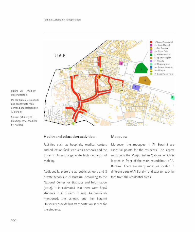
100
Part 2.2 Sustainable Transportation
Health and education activities:
Facilities such as hospitals, medical centers
and education facilities such as schools and the
Buraimi University generate high demands of
mobility.
Additionally, there are 27 public schools and 8
private schools in Al Buraimi. According to the
National Center for Statistics and Information
(2014), it is estimated that there were 8,918
students in Al Buraimi in 2013. As previously
mentioned, the schools and the Buraimi
University provide bus transportation service for
the students.
Mosques:
Moreover, the mosques in Al Buraimi are
essential points for the residents. The largest
mosque is the Masjid Sultan Qaboos, which is
located in front of the main roundabout of Al
Buraimi. There are many mosques located in
different parts of Al Buraimi and easy to reach by
foot from the residential areas.
Figure 40. Mobility
creating factors
Points that create mobility
and concentrate more
demand of accessibility in
Al Buraimi
Source: (Ministry of
Housing, 2014 Modified
by: Author)

101
Al Buraimi Integrated Urban Development: A strategic approach towards resilience
Transportation planning
procedure
The Supreme Council for Planning produces a
planning framework for the organization of the
physical development in the Sultanate of Oman.
Within this framework, the Ministry of Housing
develops Regional Plans for all regions of the
country (MOTC, 2013). Based on these Regional
Plans, the Supreme Council for Planning
designs Town Structure Plans. Such plans are
the base for development, which includes the
transportation infrastructure. In the case of Al
Buraimi, the implementing agencies are:
(1) The Department of the Ministry of
Transportation and Communications in Al
Buraimi, responsible for the highways and
regional roads, and
(2) the Buraimi Municipality, which is the branch
of the Ministry of Regional Municipalities
and Water Resources, and has the Office for
Technical Affairs regarding to the local road
network.
The Ministry of Transport and Communications
determines the priorities and schemes, thus
works such as roads improvements and
roads reconstruction are usually considered
because of poor safety conditions, congestion,
and infrastructure failure (MOTC, 2013).
Furthermore, the development of new areas
requires building more roads and transportation
facilities. The Department of the Ministry of
Transportation and Communications in Al
Buraimi and the Office of the Technical Affairs
of the Municipality have to coordinate the new
road developments, concerning the existing
and proposed services which could be affected.
Therefore, they need the information from the
agencies in charge of public services such as the
Public Authority for Electricity and Water, oil and
gas companies, telecommunication companies,
waste water companies, amongst others. The
Ministry of Housing allocates residential plots
of land to the Omani nationals. At the time that
the land is allocated, there is no transportation
or public service infrastructure. Thus, after a
considerable area has been developed then
the roads and service infrastructure are built.
There is no connection between land use and
transportation planning because they are the
responsibility of separated ministries, which find
it difficult to coordinate these two components.

102
Part 2.2 Sustainable Transportation
Figure 41. Transporta-
tion planning procedure
Source: (Author, 2014
based on the planning
procedure stated in the
Oman Highway Design
Standards)
Transportation legal framework
The Omani legislation contains 4 regulations
related to transportation:
Oman highway design manual
standards
This manual provides broad guidelines for
the responsibilities of particular authorities
and organizations involved in transportation.
This document does not only include
design standards, but also planning and
implementation procedures. These standards
have been established by a Technical Committee,
which had representation from the Ministry of
Transportation and Communications, the Royal
Police, the Supreme Council for Planning, the
Muscat Municipality, the Municipality of Dhofar,
and the Ministry of Regional Municipalities and
Water Resources (MOTC, 2013). This regulation
has been developed based on previous legal
frameworks for transportation design and
implementation. The standards were meant
for the design of highways, arterial, secondary,

103
Al Buraimi Integrated Urban Development: A strategic approach towards resilience
distributor, and access routes, which in other
words, means the hierarchy of national and
local roads. This regulation establishes some
technical codes that must be followed in the
design and implementation stages. Additionally,
it states the planning procedures for national
and regional strategies, according to the Oman
Planning Guidelines (SCTP, 2010).
Omani environmental regulations
This set of laws was created by the Ministry of
Environment and Climate Affairs in order to
prevent pollution, environmental degradation,
chemicals hazards, and damage to the
ecosystems in the Sultanate of Oman (MOECA,
2013). The law is mainly addressed to the
industrial activities which handle hazardous
chemicals. It includes the control of emissions
and noise levels, which indirectly refers to
transportation activities as well. Through
this regulation, the Ministry of Environment
and Climate Affairs issues permissions
for all activities that represent a risk to the
environment. The planning process also states
that all new roads projects need a license which
certifies that they comply with the environmental
requirements.
Oman planning guidelines
The guidelines were issued by the Ministry of
Housing; they established planning definitions
and standards for the development in the urban
and rural areas. They also set standards for
road networks and accessibility (MoH, 2014).
Furthermore, the guidelines determine the
land uses permitted along the highways and
the distances between the roads and buildings.
Moreover, the master plans must establish
the limits of the projected areas which will be
urbanized, the projected roads, and protection
areas. It also complements some of the
standards that have been established by the
Oman Highway Design Manual. The guidelines
are linked to the building codes and state the
number of required parking lots per project,
depending on the built area, land use, and
density. Finally, they determine the minimum
distances between residential areas and service
facilities.
Development control plan framework
The DCPF is a document which contains
guidelines and standards for the development
of integrated tourism projects. Consequently,
the framework encompasses standards of
transportation facilities for accessibility to
tourism complexes. They define the number
of parking lots, the type of roads and streets
to access, and traffic impact assessments.
Additionally, the standards recommend
implementing facilities such as sidewalks
and bikeways in the tourist areas, and the
preservation of the local landscape.
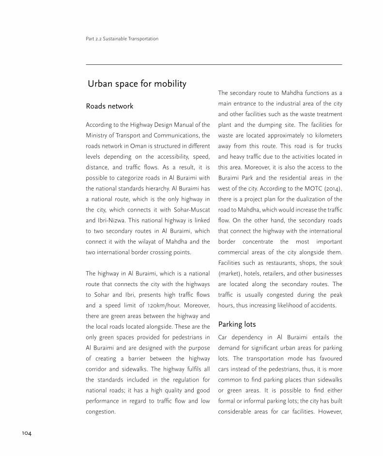
104
Part 2.2 Sustainable Transportation
Urban space for mobility
Roads network
According to the Highway Design Manual of the
Ministry of Transport and Communications, the
roads network in Oman is structured in different
levels depending on the accessibility, speed,
distance, and traffic flows. As a result, it is
possible to categorize roads in Al Buraimi with
the national standards hierarchy. Al Buraimi has
a national route, which is the only highway in
the city, which connects it with Sohar-Muscat
and Ibri-Nizwa. This national highway is linked
to two secondary routes in Al Buraimi, which
connect it with the wilayat of Mahdha and the
two international border crossing points.
The highway in Al Buraimi, which is a national
route that connects the city with the highways
to Sohar and Ibri, presents high traffic flows
and a speed limit of 120km/hour. Moreover,
there are green areas between the highway and
the local roads located alongside. These are the
only green spaces provided for pedestrians in
Al Buraimi and are designed with the purpose
of creating a barrier between the highway
corridor and sidewalks. The highway fulfils all
the standards included in the regulation for
national roads; it has a high quality and good
performance in regard to traffic flow and low
congestion.
The secondary route to Mahdha functions as a
main entrance to the industrial area of the city
and other facilities such as the waste treatment
plant and the dumping site. The facilities for
waste are located approximately 10 kilometers
away from this route. This road is for trucks
and heavy traffic due to the activities located in
this area. Moreover, it is also the access to the
Buraimi Park and the residential areas in the
west of the city. According to the MOTC (2014),
there is a project plan for the dualization of the
road to Mahdha, which would increase the traffic
flow. On the other hand, the secondary roads
that connect the highway with the international
border concentrate the most important
commercial areas of the city alongside them.
Facilities such as restaurants, shops, the souk
(market), hotels, retailers, and other businesses
are located along the secondary routes. The
traffic is usually congested during the peak
hours, thus increasing likelihood of accidents.
Parking lots
Car dependency in Al Buraimi entails the
demand for significant urban areas for parking
lots. The transportation mode has favoured
cars instead of the pedestrians, thus, it is more
common to find parking places than sidewalks
or green areas. It is possible to find either
formal or informal parking lots; the city has built
considerable areas for car facilities. However,
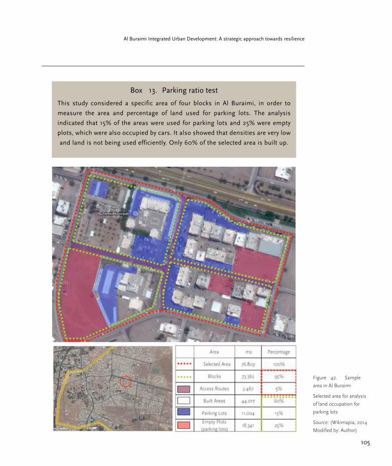
105
Al Buraimi Integrated Urban Development: A strategic approach towards resilience
Figure 42. Sample
area in Al Buraimi
Selected area for analysis
of land occupation for
parking lots
Source: (Wikimapia, 2014
Modified by: Author)
Box 13. Parking ratio test
This study considered a specific area of four blocks in Al Buraimi, in order to
measure the area and percentage of land used for parking lots. The analysis
indicated that 15% of the areas were used for parking lots and 25% were empty
plots, which were also occupied by cars. It also showed that densities are very low
and land is not being used efficiently. Only 60% of the selected area is built up.

106
Part 2.2 Sustainable Transportation
it seems that the demand for parking is higher
than the supply of available places to park. It is
common to find empty plots of land which have
not being built on within the city, these places
are usually used as parking lots when all the
other facilities are occupied. Therefore, there is
a lack of regulation to avoid the occupation of
these plots of land by cars. Areas which could
be used as public spaces with possibilities
for community interaction, enjoyment, and
cohesion are being wasted to accommodate the
high number of vehicles. Furthermore, parking
in Al Buraimi is free, lacking of regulation and
control which affects traffic congestion.
Sidewalks
Many areas have been developed without
considering pedestrians facilities, others have
either poor quality of sidewalks, reduced space
for walking, or only segments of pavement.
Moreover, the city has not built facilities for the
mobility of elderly people, children, and people
with special needs. The building codes are not
enforced to maintain the distance between
buildings and roads, there is lack of spatial
justice in the distribution of urban spaces in the
city because there is no equity for accessibility.
Additionally, prioritizing cars discourages
options for non-motorized transportation.
Figure 43. Map
of roads network in Al
Buraimi
Road network hierarchy
according to the
Highway Design Manual
criteria of the Ministry
of Transportation and
Communications
Source: (MOH, 2014
Modified by: Author)

107
Al Buraimi Integrated Urban Development: A strategic approach towards resilience
The outcomes of the survey performed within
this study show that approximately 15% of the
residents never walk, whereas 65% of them walk
below than 2 hours per week; 15% walk between
2 and 4 hours per week, while only 5% walk
more than 4 hours per week.
Development of new roads
New internal roads have been developed over
the last years in disperse/patchy developed
areas of Al Buraimi. The city has spent significant
amounts of financial resources on roads located
in the outskirts. The new infrastructure entails
high economic costs and it does not compensate
for the low benefits that it represents. The
decision makers are not considering a balanced
development and are sacrificing significant areas
of land. This is not sustainable in terms of the
environment and economy because it destroys
the local ecosystem, investing high amounts of
money without meeting the needs of the city.
Therefore, the budget for development could be
invested in a more effective manner.
Goals
The aim of this study is to propose
recommendations. Its purpose includes the
evaluation of the transportation planning
structure. Moreover, in order to fulfill the
above mentioned it is important to include the
following sub objectives:
○ To analyze the mobility patterns in Al-
Buraimi by identifying the factors which
influence urban and regional transportation.
○ To evaluate the existing transport facilities
and mobility behavior .
○ To review the current transportation laws,
regulations, strategies, planning procedures,
and how they are implemented in practice in Al
Buraimi
○ To identify the problems and challenges
that the current transportation system entails
and propose ideas on how to switch to a more
sustainable mode of transportation.
○ To establish criteria on sustainable
transportation in order to address the
dimensions of rapid uncontrolled growth.

108
Part 2.2 Sustainable Transportation
Recomendations
The analysis has provided a broad panorama
of transportation in Al Buraimi, identifying the
key issues and challenges. Thus, with the aim of
classifying the proposals, this section is divided
into governance/institutional and technical
recommendations.
Governance / Institutional
recommendations
Integration and coordination in the
planning procedure
In order to contribute to a more effective
planning procedure, it is essential to integrate
and coordinate activities among the ministries
and government institutions. Thus, the Ministry
of Transportation and Communications, the
Ministry of Housing, and the Ministry of
Regional Municipalities and Water Resources
should function using a holistic approach. By
coordinating activities, urban development
would be implemented in a more balanced
and sustainable manner. Consequently, it is
needed to establish efficient mechanisms and
instruments for the integration of development
activities. This means that plans and decisions
on housing, transportation, infrastructure,
public services, and environment should be
taken as an integrative process. Moreover, it
includes establishing a common database
for all ministries to keep all the necessary
information readily available. The planning
procedure suggests the coordination among
ministries; however, in practice it does not
function holistically and it is also necessary to
create management tools for a more efficient
implementation stage. Therefore, the Ministry of
Housing in Al Buraimi, which is the responsible
for land use administration, should integrate
the land use plan with the responsible for local
transportation network in Al Buraimi in order to
ensure more compact development.
Additionally, it is not appropriate that the
Ministry of Regional Municipalities and Water
Resources is the responsible for the local road
network in Al Buraimi. There is a disconnection
with the Ministry of Transportation and
Communications at the local level and this
is one of the reasons for the failure in the
implementation of transportation regulations.
Changing the land distribution system
The national land distribution policy should be
reformulated with the aim of using the land
more efficiently and create higher proximity. The
current system of allocating lands randomly has
led to patchy developments, wasted land, and
urban fragmentation. The process of distribution
should also enforce the construction on the plot
of land and the simultaneous development

109
Al Buraimi Integrated Urban Development: A strategic approach towards resilience
of urban facilities and services for those plots.
This process should encourage a compact
urbanization, by ensuring useful occupation of
land. It is important to consider mechanisms
that compel people who receive plots by draw
to build on them. Therefore, by refocusing the
land allocation on people who are genuinely
determined and financially able to build, the
urban areas would have higher densities, better
access to services, and an improved quality of
public spaces.
Integration of land use and
transportation planning
The integration of land use and transportation
planning is a key recommendation in order
to reduce the need for new roads, and
build infrastructure more efficiently. The
Ministry of Housing should tie land use
administration policies with transportation
planning, coordinating the planning process by
establishing strategies addressed to achieving
this holistic approach. In addition to the
integration of planning activities, two strategies
are proposed:
○ Nodal Development: Al Buraimi should
concentrate high densities and mixed land uses
in strategic points of the city, as mentioned in
part 2.1.
○ Walkable Communities: Al Buraimi
should provide the facilities for non-motorized
transportation (biking and walking) which
encourage people to adopt a healthier life style.
Review of laws and regulations
The overall national policy on transportation
should be reviewed and reformulated in order
to convert to a more transit oriented policy.
Afterwards, the Oman Highway Design Manual
Standards, the building codes, and the Omani
Environmental Regulations should be modified
in order to adjust to the needs of sustainable
development.
○ Review of the Oman Highway Design
Manual Standards: As mentioned, the national
policy on road based transportation should
be reconsidered. Therefore the standards
should be developed in more depth for the
local transportation network, defining codes
that minimize car dependency by providing
facilities for walking and biking. The regulation
should also establish clear responsibilities for
the implementation of the local network and
more efficient mechanisms for monitoring and
enforcement.
○ Review of the building codes: As a
complement to the review of the Oman Highway
Design Manual Standards, the building codes

110
Part 2.2 Sustainable Transportation
should support the allocation of the urban
spaces for pedestrians. Therefore, the codes
should consider the minimum distance between
buildings and local roads and the obligation
to build sidewalks. They should also regulate
the number of parking lots and reduce the
occupation of public spaces by cars.
○ Introduction of parking fee: This proposal
might work with the aim of regulating the use
of public spaces for parking lots. It would also
contribute to reduce car use due to the fact that
it is currently free to park anywhere in the city.
This initiative has been implemented in Muscat,
where there was a limitation of parking lots
in the city centre. Thereby, priced parking was
successfully established to reduce the demand
of parking lots, discouraging car use, and
reducing traffic.
○ Regulations to reduce car use: The
affordability of cars generates a challenging
perspective in minimizing automobile
dependency. Therefore, in order to reduce car use
and accidents rates, other actions beyond speed
controls and cameras might be considered. The
Royal Oman Police is currently doing awareness
campaigns to encourage consciousness about
driving behaviour. Nevertheless, this action
should be complemented by adopting more
thorough driving tests and procedures to
receive a driving license should be established
in Al Buraimi. Only people who demonstrate
responsibility, ability, and good driving behaviour
in the tests should be allowed to possess a
driving license.
○ Review of the Omani Environmental
Regulations: This law should encompass
the impacts of roads and transportation
infrastructure on the environment. It is currently
focused on emissions and the roads building
process; nevertheless the regulation is not
relevant in terms of protecting the ecosystems.
Moreover, the law should limit the range of
the extensions of lands that are meant to
be developed, in order to integrate all the
environmental issues. Additionally, with the aim
of supporting environmental preservation, it is
highly recommended to establish a branch of
the Environment Society of Oman in the city.
Monitoring and enforcement
It is essential to establish more efficient
and effective instruments and mechanisms
to implement at the local level in order to
comply with the national laws and regulations.
Therefore, strict enforcement, controls, and
inspections are needed in order to follow the
legal framework. By increasing monitoring and
inspections, compliance will also increase.
Thus, the implementation process will follow the

111
Al Buraimi Integrated Urban Development: A strategic approach towards resilience
guidelines, standards and codes stated in the
transportation legislation. The proposal is that
for all new transportation projects in Al Buraimi,
inspections by the Central Government and the
Governorate should be made during the different
stages of the project execution. Consequently,
the transportation implementation agencies
are forced to know the legal framework and
operate according to it. In the case of inspectors
finding an abnormality or non conformity,
the implementation agency should be made
responsible to take the corrective actions.
Decentralization
More autonomy, in the Governorate of Al
Buraimi to decide on transportation plans and
projects in their city-region, is needed. The local
government has more knowledge regarding
the actual needs, priorities, problems, and
challenges of its city-region than the Central
Government of Muscat.
The process of decentralization may take a long
time, nevertheless, efforts have to be made
and there should be more flexibility for the
governorates and municipalities in decision
making. In the process of decentralization, it
is essential to have political acceptance from
the Central Government to transfer certain
powers to the different levels. Additionally, the
transportation legal framework should define
the responsibilities among the different actors
involved.
The first step of decentralization was made in
2011 through the creation of the municipalities in
the Sultanate of Oman. Therefore, the next step
is that the National level considers distributing
additional administrative, political, and fiscal
autonomy to the regional and local levels with a
long term projection.
The process must be gradual in order to not
disrupt the current governmental structure. For
instance, the Governorate of Al Buraimi should
have the autonomy to decide on regional new
roads and linkages according to the priorities in
terms of transportation of goods, tourism and
residents mobility.
The Municipal Council of Al Buraimi should play
an essential role in strengthening the power in
the regional and local level in transportation
planning and decisions. Consequently, when
the process takes place, the levels of public
engagement and involvement will increase as
well. Decentralization is a key tool to promote
urban sustainable development by focusing
more closely in the local community.

112
Part 2.2 Sustainable Transportation
Public involvement
In order to initiate a more integrative and holistic
planning approach in Al Buraimi, it is important
to increase the level of public engagement in
planning and sustainability. Therefore, residents
in Al Buraimi should get progressively more
involved in urban planning procedures. The
residents are a key player in identifying the real
needs and priorities of the community and they
should have the right to express opinions, ideas,
and criticisms on the city’s transportation. Thus,
the decisions would be more inclusive, and
effective, in terms of benefiting the public.
This is a long process which could be started by
involving the schools and university students,
with activities such as student proposals and
competitions regarding transportation. In
the efforts to involve all groups of society, the
Municipal Council of Al Buraimi should play a
key role in attracting the residents to participate.
As a result, new ideas, concepts, and proposals
can arise from the citizens according to their
needs.
Furthermore, the process should integrate the
expatriate residents, which count for around
50% of the total population in Al Buraimi. The
immigrants are part of the city and need to be
Figure 44. New road
in Al Buraimi
Patchy developed area
with a new road for
the accessibility of only
few housing units. The
urbanization does not
follow a coherent process.
Source: (Author, 2014)

113
Al Buraimi Integrated Urban Development: A strategic approach towards resilience
included and participate in planning as well.
They also have needs for urban and regional
mobility which represents transportation
demand. According to the community surveys,
the non-nationals are the most disadvantaged
group in the city. Consequently, the process
should not marginalize any group and should be
fair and equal by providing the same conditions
for everyone.
Public / political acceptability and
adaptability
It is also necessary to establish a process which
includes the following:
○ Public and political acceptability: The aim
of reducing car dependency depends on public
support. Therefore, the community should be
aware of sustainability and the negative impacts
of the current car based mode of Al Buraimi.
Firstly, the concepts of sustainability should
be clearly conveyed to the residents through
campaigns and programs. Secondly, creating
awareness, consciousness, and education
through campaigns can encourage people to
adopt more sustainable practices.
○ The campaigns can be carried out in
cooperation with the media, schools, the
Buraimi University College, the Royal Police of
Sidewalk in Al Buraimi
There is not space for
pedestrians and there is
an insufficient distance
between the buildings
and the road. There is no
possibility to walk in an
exclusive space.
Source: (Author, 2014)

114
Part 2.2 Sustainable Transportation
Oman, the Ministry of Environment and Climate
Affairs, and the Environment Society of Oman.
Meanwhile public support for change will lead
to political acceptability because this is the main
way to influence political thinking (Banister et
al., 2007).
Adaptability: Once public and political
acceptability has been achieved, the
implementation of a more sustainable
transportation mode in Al Buraimi needs a
complementary process of adaptability. This
encompasses both residents and government.
On the one hand, the citizens need time and
guidance to adapt to walking or biking. It is
challenging to persuade people to stop using
private cars when they offer comfortable
transportation at affordable prices. Nevertheless,
this process of change of behaviour is based
on campaigns and educational programs for
raising consciousness. Thus, people need
to learn how to use the facilities for non-
motorized transportation, and how to respect
the reallocation of sidewalks and public spaces
to pedestrians. It is important to emphasize the
benefits that this shift represents for individuals
and the community in terms of health,
accessibility, environment, etc.
On the other hand, the government of Al
Buraimi needs adaptation as well because
it will be necessary to change institutions,
administration, and governance. This is the
most challenging aspect in the adaptation of
sustainable transportation as it does not only
depend on the local government of Al Buraimi,
but also on the Central Government in Muscat,
due to the strong centralized structure of the
Sultanate. Nevertheless, restructuring the
institutions and reviewing governance is needed
as part of the process.
Technical recommendations
This part is focused on the technical proposals
which would complement the governance
recommendations. Additionally, in order to
contextualize the technical recommendations
in Al Buraimi, it is necessary to consider the
weather conditions, the local identity, and the
local customs. These features will determine,
technically, how to design and implement the
facilities and infrastructure.
Facilities for walking and biking
Al Buraimi should provide the facilities for non-
motorized transportation such as walking and
biking. This effort aims to improve the local
environment and it is focused on a small scale.
Moreover, it would improve the public health,
air quality, security, and overall spatial justice.
Therefore, the following points are proposed:
115
Al Buraimi Integrated Urban Development: A strategic approach towards resilience
○ Pedestrian facilities: It is challenging to
propose pedestrianization due to the weather
conditions and car based culture of the society.
Nevertheless, efforts have to be made in order
to provide quality public spaces to the residents,
supported by the transportation and building
regulations and guidelines.
The benefits of the process of pedestrianization
in Al Buraimi is that it would definitely improve
the accessibility conditions of the community,
including the most disadvantage groups such
as people with special needs, children, elderly
people, and immigrants as well. As a result,
the city would be more inclusive for all society
groups. On the other hand, taking into account
that Al Buraimi has high temperatures over
the year and this condition might discourage
walking, it is important to provide sidewalks
and public spaces that are sheltered from direct
sunlight. As a result, it is proposed to consider
landscaping in planning and urban design.
○ Biking facilities: The network of bike lanes
could be distributed along the main routes. It is
important to point out that the Omani society
is not used to biking. Nevertheless, there is a
significant number of immigrants who do not
own a car and require mobility.
Additionally, a pilot project of renting bikes
could be implemented. In many places of the
world, renting bikes has been successfully
adopted. Al Buraimi might set up this mode as
an experiment at first, in the case that it works,
it can be set up permanently. Al Buraimi would
become a pioneer as it would be the first city in
the Sultanate of Oman to implement bikeways.
Landscaping
Landscaping should be considered in order
to provide shade, road noise attenuation,
separation between the car lanes and pedestrian
paths, improvement of air quality, and better
urban space aesthetics. Additionally, it would
be an opportunity to recover the local identity
through restoring the native species of plants.
Considering that the governorate is a dry place
with scarce water resources, the proposal
focuses on the use of trees requiring less
water which have a significant surface area to
provide shadows. According to the Environment
Society of Oman (2010), there is a group of
native trees proposed in order to conserve the
traditional cultural landscapes. As a result, the
proposed species from this group which meet
the functional needs for sidewalks are: Ghaf
(Proposis cineraria), Sidr (Ziziphus spina-christi)
and Sherish/Naim (Azadirachta indica).

116
Part 2.2 Sustainable Transportation
Furthermore, in case there are sidewalks which
are not suitable for trees or plants (i.e. due to
space constrains), another solution to provide
shade is through the installation of pergolas.
This is a traditional Omani architectural element
which could be used for this purpose in addition
to the identity value that it contains.
Al Buraimi’s own public bus system
The pilot experiment proposed is the
implementation of buses with a dedicated lane.
They should have specific stops strategically
located in the places with higher volume of
people. Additionally, they should operate on the
main distributor routes of the city.
Meanwhile, the local government should
educate the residents on how and why to use
the public transportation system through
campaigns and programs. Furthermore,
considering that Oman has traditionally strict
rules in the relation between men and women,
it is also proposed to provide separated areas in
the buses for each gender. Thus, people would
feel more comfortable when using the service.
The implementation of the public transport
system could create conflicts with the current
taxi service. As mentioned before taxis are the
only available service for local journeys, and
drivers would lose revenues in the event of
having competition. Consequently, the proposal
Figure 45. Public
transportation plan
Source, Author, 2014
117
Al Buraimi Integrated Urban Development: A strategic approach towards resilience
is to integrate the public transportation network
with the taxi service. Thus, taxis could be
rethought as semi public, sharing the bus stops
and lines.
The aim of the pilot plan is to integrate the
different modes of transportation without
excluding or compromising the existing services.
In addition, the network could be linked with
biking by installing bicycle parking racks at the
bus stops.
On the other hand, it would be important to
coordinate activities between the government
and the public sector through partnerships in
order to manage the operation of the bus service.
Thus small and medium enterprises would have
the opportunity to develop businesses with
services that are efficient for the city and support
the local economy. Another important aspect to
be considered in the implementation stage is the
service pricing. They make private transportation
very affordable for people. Therefore, efforts
have to be made in order to provide the public
transportation service with affordable prices as
well. The key point is to create awareness in the
citizens on the importance to reduce car use
and the benefits of using the public transport
network in terms of efficiency and cost.
Transit oriented development
The TOD model could be implemented
as a model for integration of land use and
transportation. According to experts, the
concept of this model is to concentrate mixed
land uses, dense areas, and pedestrian friendly
developments around the main roads to provide
walking, biking, and alternatives to the use of
private cars. Thus, TOD would be potentially
suitable in the case of Al Buraimi, considering
that the city has concentration of activities and
densities at certain points.
The current activity centers were indicated in the
analysis of local mobility creating factors. As a
result, if these strategic points are focused on
creating nuclei by increasing densities and mixed
land use, in addition to the provision of facilities
for non-motorized and public transportation,
Al Buraimi could adapt and implement this
concept. Therefore, the development process
would be more sustainable by creating a more
compact city. It should be seen as a tool to
slow down sprawl and reduce car dependency.
Moreover, in these nuclei strategically located
in the city, the bus stops proposed in the public
transportation system should be placed.

118
Part 2.2 Sustainable Transportation
On the other hand, it is essential to set a
planning strategy to implement TOD model
which responds to the local priorities. The
strategy contains key principles that must
be fulfilled to guarantee the implementation
success: (1) Make full use of urban land, (2) Plan
with communities, (3) Encourage public over
private transport, (4) Strengthen local sense of
place, and (5) Develop strategies to create local
jobs.
Thus, it is also relevant to include the concept
of “complete neighbourhood”, which provides
choices for housing and employment, as well
as retailers, schools, medical centres, worship,
public spaces, and public transportation.
Consequently, the TOD model implementation
would bring better living conditions to the
city residents by creating green corridors and
more accessibility. The concept of TOD is
schematically visualized in the graph above.
An area that can be considered to start a TOD is
where the market (souk) is located and includes
commercial corridors, hotels, restaurants and
retailers, in addition to heritage sites which will
potentially become tourist attractions.
Another site is the area located in the main
roundabout which contains the main Mosque,
Figure 46. Transit
oriented development
TOD concept
Source: (Institute for
Transportation and
Development Policy, 2013
Modified by: Author,
2014)

119
Al Buraimi Integrated Urban Development: A strategic approach towards resilience
bus terminal, Governorate office, commercial
areas, health care facilities, among others. This
is a point of the city with density and potential to
become a node in the TOD model. The proposal
is to densify these two areas, providing facilities
for walking and biking, integrating residential
use within the area of influence, as well as
limiting the occupation of public spaces for
parking lots, and using the node centres for the
bus stops.
Furthermore, there is a third area which has low
density, but is strategically located considering
the proximity of different land uses such as
commercial, residential, and recreational. This
Figure 47. Activity
centers
Potential Activity Centers
in Al Buraimi for TOD
Implementation
Source: (Wikimapia, 2014
Modified by: Author, 2014)
area contains the Buraimi Park, the Buraimi Sport
Complex, the Buraimi Hospital, the Buraimi
Hotel, shops, among others. Therefore, it could
be developed as an activity centre by integrating
more varied land uses and increasing densities,
as well as linking it with public transportation.
Additionally, these three potential activity centres
might be connected by the pilot project of public
transportation. The bus routes should operate
in the densest areas of Al Buraimi where there is
more compact development. At the same time,
the public service operation should operate
mainly along the main distributor routes and
partly on the highway.

120
Part 2.2 Sustainable Transportation
The implementation of TOD is envisioned in
the medium term if the planning structure
is reformulated and actions are taken in the
short term. On the other hand, considering the
projected growth of urbanization in Al Buraimi,
which has been planned by the Ministry of
Housing, it is proposed to include activity
centres in the new developed areas. The nodes
should be located along the main distributor
route, which according to the master plan, is
proposed to be built when the area has been
urbanized.
Improvement of regional public
transportation
The current interregional public transportation
system is not operating efficiently and needs
urgent updating. Therefore, the proposal is
to improve the regional linkages by increasing
coverage, frequencies, and punctuality through
the operation of new updated buses which also
provide better conditions for the passengers.
The Oman National Transport Company should
improve the quality and quantity of the bus fleet
operating in the region. Moreover, it is advisable
to improve the bus terminal facilities due to its
size not being appropriate for high volume of
passengers. There are no waiting spaces and the
process of tickets purchase is not functional.

121
Al Buraimi Integrated Urban Development: A strategic approach towards resilience
Figure 48. Action
management plan
Governance/Institutional
Recommendations
Source: (Author 2014)
Figure 49. Technical
recommendations
The action plans for the
implementation of the
governance and technical
proposals are illustrated in
the following page.
Source: (Author, 2014)
Action / management plan
Proposed technical actions
: proposed governance actions

122
Part 2.2 Sustainable Transportation
Figure 50. Rounda-
bout sign
Source: (Carvajal, 2015)
Conclusions
Sustainable transportation is not about radically
stopping car use, it is about reducing car
dependency through the implementation of
mixed land use, higher densities, proximity,
accessibility, public transportation, non-
motorized transportation, and alternative energy
usage. Thus, Al Buraimi should adopt a holistic
transportation approach that provides access to
citizens minimizing the social, environmental,
and economic impacts. However, it needs
reformulation of governance, planning
procedure, and the legal framework in order
to establish the basis for its implementation.
In addition, it is necessary to achieve public
and political acceptance for a new mode of
planning and transportation. Moreover, political
will in the different levels of the government
could make the difference to overcome the lack
of integration, coordination, and inadequate
planning. The community needs time to adapt
to the new ideas, and the role of the government
is essential in guiding the citizens in this process
through campaigns and programs. These ideas
could be applied to other urban areas of the
Sultanate of Oman in the event of successful
implementation in Al Buraimi, which could
become the first city in the country to adopt a
new approach to transportation.

123
Al Buraimi Integrated Urban Development: A strategic approach towards resilience
References
Banister, D. (2008). The Sustainable Mobility
Paradigm. Transport Policy, 15(2), 73–80.
Banister, D., Pucher, J., Lee-Gosselin, M. &
Lee, M. (2007). Making Sustainable Transport
Politically and Publicly Acceptable: Lessons
from the EU, USA and Canada. Institutions and
Sustainable Transport: Regulatory Reform in
Advanced Economies, Cheltenham, England:
Edward Elgar Publishing, 17–50.
Cervero, R., Bertolini, L., Curtis, C., Renne,
J. & Newman, P. (2009). Transit Oriented
Development Making It Happen.pdf.
Cohn, M. (2009) Four Attributes of the Ideal
Pilot Project. Mountain Goat Software.
Environment Society of Oman. (2010). Omani
Native Trees Species
Fausold, C. J. (1996). The Economic Value of
Open Space.pdf.
Handy, S.L. & Niemeier, D. (1997) Measuring
accessibility: an exploration of issues and
alternatives. Environment and Planning A vol.
29.
Hillman, M. (1993). Children, Transport and the
Quality of Life.
Hutton, B. (2013). Planning Sustainable
Transport.pdf.
Institute for Transportation and Development
Policy (2013) TOD
Kenworthy, J. R. & Laube, F. B. (1996).
Automobile Dependence in Cities: An
International Comparison of Urban Transport
and Land Use Patterns with Implications
for Sustainability. Environmental Impact
Assessment Review, 16(4), 279–308.
Laing, R., Tait, E. & Gray, D. (2012). Public
Engagement and Participation in Sustainable
Transport Issues.
Litman, T. (2000). Reinventing Transportation.
Victoria Transportation Policy Institute.
Retrieved November 6, 2014
Litman, T. (2002). The Costs of Automobile
Dependency. Victoria Transportation Policy
Institute
Litman, T. (2008). Well Measured. Developing
indicators for comprehensive and sustainable
transport planning. Victoria Transport Policy
Institute.
124
Part 2.2 Sustainable Transportation
McEldowney, M., Ryley, T., Scott, M. & Smyth,
A. (2005). Integrating Land-Use Planning
and Transportation in Belfast: A New Policy
Agenda for Sustainable Development? Journal
of Environmental Planning and management,
48(4), 507–526.
Mega, V., Pedersen, J. & Fondation europeenne
pour l’amelioration des conditions de vie et de
travail. (1998). Urban Sustainability Indicators.
Luxembourg: Office for Official Publications of
the European Communities.
Mobility Management Measures. (2013). C05_
Experience Public Transport.pdf.
MOECA. (2013). Omani Environmental
Regulations.pdf.
Newman, P. & Kenworthy, J. (1999).
Sustainability and Cities: Overcoming
Automobile Dependence. Island Press.
Schiller, P. L., Brun, E. C. and Kenworthy, J.
R. (2010), An Introduction to Sustainable
Transport: Policy, Planning and
Implementation, Earthscan, London.pdf.
Scott, M., McEldowney, M. & Ryley, T. (2005).
Urban Form Reducing Demand of Car Travel.
pdf.
Statistical Year Book. (2014). 2-Population.pdf.
UN Habitat. (2013). Planning and Design for
Sustainable Urban Mobility. Global Report on
Human Settlements. pdf
Weerakoon, R. & Kumar, A. (2013).
Sustainability in Post Disaster Road
Infrastructure Recovery Projects and Asset
Management, in: 4th International Conference
on Structural Engineering and Construction
Management.

125
Al Buraimi Integrated Urban Development: A strategic approach towards resilience

Part 2.3 Infrastructure DevelopmentPanagiotis Achamnos

There are a lot of factors that have contributed
to the current situation in the city of Al Buraimi,
Oman. Infrastructure provision faces a lot
of challenges in the area, serving to support
the rationale for this research, which focuses
on the three key services: fresh water supply,
solid waste management, and wastewater
treatment. These play an important role towards
the sustainable growth of a city. The land
distribution system in Oman played a major role
in contributing to this scattered development of
the city, and as a consequence to the challenges
and subsequential problems in providing basic
services to inhabitants in a timely manner.
Because of the fast growth of the city, which
happened as horizontal urban sprawl and not
increased vertical urban density, as the city
grew towards the outskirts, the basic services
have not been unable to reach the new areas
of the city in a reasonable time. This happened
because of the time needed for planning and the
expenses, which are higher due to the scattered
development of the city. As a result, the main
fresh water network covers only around 80
percent of the city, the sewage system covers
only a 30 to 35 percent of the city and is located
basically in the city centre. Regarding the solid
waste management of the city, the rapid growth
of the city has consequently led to the rapid
growth in the amount of solid waste. Thus, it
becomes more and more difficult for the city’s
solid waste management authorities to cope.

128
Part 2.3 Infrastructure
Assesment of the current
state of infrastructure
Taking into consideration the rapid growth
of the city in the last years and the weather
conditions, we can understand the risks that the
basic infrastructure faces, especially the fresh
water supply, solid waste management, and
wastewater management and treatment. These
are:
○ Services arrive after the inhabitation of
the areas in the outskirts. Because of that rapid
growth and the exploitation of the city, the
services that are currently available cannot cope
and serve in the same way they used to with a
much lower population.
○ An increase in solid waste that the city
produces, and at the same time that the solid
waste department is not capable of managing.
The city services lack in personnel and in
facilities.
○ The wastewater management of the city
faces the same problem, as the amount of daily
wastewater that has to be treated rises every
year.
○ The fresh water supply faces the same
challenges, as it has to serve every year more
and more people.
○ Increasing demand for plots to allocated
(RD 81/84 and RD 125/2008)
○ Lacking coordination between institutions
in charge
An interview with the director of the Ministry of
Regional Municipalities and Water Resources
in Al Buraimi complements and adds more
information. The central government wants
to preserve the local architecture character
and personality. There is a minor committee
searching for new ideas to build in a more
environmentally friendly way .
In the last four years, 5000 building permits
were granted from the municipality, 80 per cent
of them for residential houses and villas, and
almost 170 kilometres were added to the city’s
length. In the next five years it is expected that
the whole of Al Buraimi will be full. In 2014
alone, 800 building permits were granted.
Another point is that people working in UAE,
in Al-Ain, prefer to live in Al Buraimi because it
has a lower cost of living. There is also the case
that a lot of the population from the country is
moving to Al Buraimi. It is developing rapidly,
more than any other city in Oman.
Previous page:
Water delivery in Al
Buraimi
Source: (Salcedo, 2014)

129
Al Buraimi Integrated Urban Development: A strategic approach towards resilience
There is a five-year plan for every project-plan
in Oman, including infrastructure projects. The
municipality applies for the amount of money
they need for basic services in a five-year plan
and usually only 20-50 per cent is granted from
the central government. They are now looking
to clarify what and how many services will be
needed in the future in order to change their
perspective in a long-term plan rather than in
the short-term. Specifically for infrastructure,
there are short-term plans, for one year, but
there are also some five-year plans to apply in
the government, like the sewage system plan.
Only 30-35 per cent of the city is connected to
the sewage system, the rest of the city uses
septic tanks.
Box 14. Land allocation
The land law, Royal Decree No. 81/84, states that every Omani citizen has the
right to be granted a residential plot through a public lottery, a public draw,
which is carried out by the Ministry of Housing. Up until 2008, only men were
granted residential land through that drawing throughout the whole Sultanate.
With Royal Decree No. 125/2008, the previous Royal Decree was amended,
allowing women to also participate in the lottery and receive the rights to a
residential plot. This new Decree also stated that each participant in the public
lottery should not be less than 23 years old, or less than 21 years old if he/she
is married (Al Gharibi, 2013). These plots are between 600 square meters and
1000 square meters and when granted there are no basic services available.
There is not an entire framework where all the departments can take decisions
together and this is the main problem: a fragmentation of responsibilities. After
the people get the plots, they can apply for the basic services, but usually it takes
two to three years for the services to arrive. The distribution of land is so rapid
that at the moment there is a lack of vacant land in Al Buraimi to distribute to
people. But the main problem remains; the basic infrastructure has (yet) to join
the planning (MoH, personal communication, September 22, 2014).
130
Part 2.3 Infrastructure
Solid waste management
Currently, there are negotiations with a private
company. This was arranged by the central
government and sent to Al Buraimi, to take
charge of the whole solid waste management of
the city, as the municipality cannot cope with the
growth of the city. The municipality will just focus
on the supervision of the whole management.
The attempts of the municipality to inform people
through campaigns in schools, universities,
worship sites, newspapers, television, and by
the distribution of three different colours of
plastic bags to the people (in order for them
to recycle), seems to have had no significant
result .There is no recycling taking place in
the city (MRMWR, personal communication,
September 23, 2014).
Moreover, the fresh water supply - arguably the
most important basic service for a city and its
inhabitants - is facing a lot of risks. First of all,
there are the weather conditions and the amount
of rainfall, as previously mentioned, which
have a negative impact in the water resources
of the area. Secondly, the rapid growth of the
population and the increase on the demand of
water make the situation more problematic.
One of the main issues is the shortage of water
in Al Buraimi. That issue causes problems in
different areas of the city. It does not allow the
people to have the facilities and the leisure parks
they need, but also restrains the promotion
of the business sector, as investors are not
attracted to the area (Chambers of Commerce,
personal communication, September 29, 2014).
The Public Authority for Electricity and Water
(PAEW) is responsible for the distribution of
fresh water in the city. After 2008, the city of
Al Buraimi has been supplied with desalinated
water coming from the city of Sohar while
the water from underground resources and
wells is used only in special occasions and
circumstances. PAEW continues to follow the
Government’s policy of reducing reliance on
groundwater for drinking water, and the plans
continue to envisage increasing reliance on
large-scale desalination as the main source
of drinking water in Oman. The authority is
also focusing on the reduction of water losses
(leakages, theft, etc.) and as a result to reduce
the subsidy that is needed (Annual Report,
Public Authority for Electricity and Water, 2013).
The fact is that the access to drinking water and
sanitation has increased in the whole country in
the last 20 years, and the investment in these
facilities played a vital role in the reduction of
the child mortality rate in Oman, with a decrease
of 37.9 per cent between 1990 and 2010.

131
Al Buraimi Integrated Urban Development: A strategic approach towards resilience
In total, the three basic services are facing
challenges and inefficiencies that first arise
from the management and the administration.
There are some administrative obstacles, the
management is highly centralized and there is a
lack in planning within regions. The authorities
inside the governorate do not coordinate with a
vision and strong urban planning management
is absent.
Another side effect of the lack of infrastructure,
which was mentioned in our meeting with the
Ministry of Environment and Climate Affairs,
is that there are some industrial activities very
close to residential areas. Despite the ministry’s
attempts to relocate them into the industrial
zone, far enough from the residential areas,
this is not possible because of that lack of basic
services. People are difficult to be convinced to
shift somewhere where no basic infrastructure
is available (MECA, personal communication,
September 28, 2014).
Fresh Water Supply
Water is not only a vital element for our life
but also a resource and foundation for a lot
of different development fields. Nowadays, all
around the world, countries and people are
facing the challenge of water shortages, as well
as its ensuing limitations, and are looking for
different means and solutions to reduce the
waste of water in addition to finding more ways
to maximize the present water resources so as
to increase its availability.
In the Sultanate of Oman there are different
resources of water, but they vary depending on
the region of the country that is being referred
to. First of all, there is surface water — water
from rain and from the mountains that flows
through the rivers that are called ‘wadis.’ Due
to the low precipitation that can be affected by
some factors such as storms and low pressures,
the availability of surface water is declining
and there is a phenomenon of having more
wadis and aflaj throughout the country dry up.
Secondly, there is groundwater. The ground
aquifers can be characterized as renewable or
non-renewable, depending on whether they
can be fed through rainfall or not. Due to little
rainfall, the groundwater resources are declining
throughout the country and the government
is trying to minimize the use of underground
water as much as possible, as will be analysed
below. And thirdly, there are the water springs
where the water flows naturally from the ground
to the surface.
From the sources to the people
Besides these sources, there are different water
systems in order to acquire and transport water.
There is an ancient method, called Al Zajirah,
132
Part 2.3 Infrastructure
which operates by elevating groundwater. There
is also the famous Aflaj system, channels that
transfer and transport water, the reservoirs,
which are storage systems of rainwater, and
the different types of dams (recharge, surface
storage, flood protection, etc.). Furthermore,
there are the water desalination plants where the
salt from the seawater is removed and the water
product can be used as fresh water through
specific processing. The desalination plants
have been exploited over the last few years
in Oman and they are basically providing the
majority of fresh water. The wastewater stations
are only used to provide treated water for
irrigation purposes (MRMWR, Water Resources
in Sultanate of Oman, 2013).
Water in Al Buraimi through the years
Before the connection to the desalination plant
from the city of Sohar, which we will analyse at a
later stage of the study, the city of Al Buraimi was
supplied with water from wells, underground
water, and water coming from the aflaj (water
canals that are used in the whole region for
more than 3000 years, for human settlements
and irrigation purposes). More than a thousand
years ago the people of the Sa’ara village in
Al Buraimi brought water from more than 30
kilometres away, from springs in the mountains
that belong to Oman, making a channel from
the mountains to their settlements in order to
provide water for their farms, their products, and
their animals. That aflaj, which is going through
the Sa’ara village in Al Buraimi, has been dry for
around 30 years. Peoples perception regarding
the reasons why the aflaj is dry, are very diverse.
Religion is common to get mixed with water
issues. In a climate situation as Oman’s, where
it is mountainous and arid, the water is received
underground or below dry riverbeds, which in
Oman are called “wadis”.
Water in the aflaj was carried in open channels
and was distributed to the community firstly
to the mosque and for drinking, and secondly
for washing and irrigation purposes. The
management was so carefully made, that there
were no epidemics recorded in the whole Arab
Region (Ragette F., 2012, Traditional Domestic
Architecture of the Arab Region, American
University of Sharjah, Third, unrevised edition).
According to Parry (1998), despite the research,
no one can be sure about the origins of the aflaj
in Oman and how old the oldest channels are.
However, the aflaj in Yemen may show that those
in Oman came from necessity and not from
outside involvement. In addition, the mining
industry in Oman during the third millennium
BC required a readily available supply of water,
which could be achieved by a system such as
the aflaj.

133
Al Buraimi Integrated Urban Development: A strategic approach towards resilience
Figure 51. Thaqbah
well
Source: (Author, 2014)
Figure 52. Production
from wells,
Al Buraimi
Source: (Annual report
2013, PAEW)

134
Part 2.3 Infrastructure
Water management
The water management in Al Buraimi, as
well as in the rest of the country, is divided
into two sections: The management of the
water resources, which is overseen by the
water resources department of the MRMWR,
and the distribution of the water, which is
the responsibility of the Public Authority for
Electricity and Water (PAEW).
The department of the water resources has three
different sections. The first section handles the
monitoring and the studies that are concerned
with the natural water resources, such as
the wadis, aflaj, wells, rainfall, etc. There are
monthly or quarterly measurements and reports
regarding this monitoring.
The second section deals with the provision of
permits regarding the wells in order to protect
the sources, in accordance with the laws and
regulations of the Sultanate. These permits have
to do with different demands from the people;
such as calls for cleaning a well, making an
existing one deeper, or even digging a new one.
For any project of that kind, public or private,
a study work is needed from that section of
the department in order to proceed and for
the approval of the request. This section aims
to investigate whether the project affects the
ground and the surface water, and if the project
itself is safe from potential floods.
The third and last section of the department
deals with the dams and the aflaj, underground
or on the surface. Regarding the dams, the
studies that the department fulfils serve to
establish if a new one is needed or not. At the
moment, there are about six dams in the area,
five of them are recharging ones and one serves
as storage (above the surface).
The main challenge of the department is to
“protect the underground water and save it,
as population and demand are growing fast”
(Water Resources Department, MRMWR,
personal communication, October 1, 2014).
Extraction, desalinization and
distribution
In the whole governorate of Al Buraimi, there
are around 7000 wells, private and public, in
farms. There is no allowance to have a well in
a house, only under specific conditions and
circumstances. The department is responsible
to grant any permit only after it has conducted
a study, as mentioned above, regarding such
a request. Nevertheless, there are some
occasions during which people proceed with
the construction of their own well without the
permission of the department, but for these
cases there are fees according to the laws for the
act of illegally digging a well.

135
Al Buraimi Integrated Urban Development: A strategic approach towards resilience
The second authority, the PAEW, is responsible
for the distribution of water. PAEW works in
cooperation with the department of water
resources regarding underground and surface
water and its use.
Before 2008, the area of Al Buraimi was served
by groundwater and wells. As the population was
increasing and simultaneously the groundwater
level was declining. The government could not
depend any more on groundwater resources for
the area, and as a result they proceeded with the
connection of the city to the desalination plant of
the city of Sohar, which is the closest coastal city
to Al Buraimi. In the desalination plant in Sohar a
process called “Multiple Stage Flash Distillation”
is used. A most recently developed process for
reliable and efficient water desalination is called
“reverse osmosis”, or R.O., but that type is not
yet used in Sohar. From Sohar the desalinated
water is transported to Al Buraimi through pipes,
pump stations, and transmission connections.
After the reduction in the use of water from the
wells, it can be said that nowadays the level of
the groundwater in Al Buraimi is stable except
during the dry seasons, when that level drops.
In addition, the groundwater from the wells is
being used nowadays only in emergency cases
and in cases of high demand (PAEW, personal
communication, October 1, 2014).
Local water network
The network distribution in Al Buraimi increased
over the last few years as a result of the
improvement and the extension of the water
network system, but also due to the growth of the
population. Another fact that is more important
is the increase of the production from wells that
was very significant for the last year, as it has
increased by 34 per cent. This demonstrates that
the government’s general policy for reducing
reliance on groundwater for the supplies of
drinking water and general use, in most cases,
wells that go to support small isolated networks
Minimum water recharge
In the last 15 to 20 years there has
been a dry period in the area and
because of this there has not been
adequate recharging of the dams,
ground and underground water,
as the precipitation has been low.
Something that is obvious from the
rain gates and the measurements
of rainfall from the department. In
addition to this situation, there is
also the lack of awareness on the
part of people who do not care about
water resources (Water Resources
Department, MRMWR, personal
communication, October 1, 2014).

136
Part 2.3 Infrastructure
or tanker filling stations in areas that are not yet
connected to the main networks is working.
Another objective of the Public Authority for
Electricity and Water is to ensure the best quality
of water is provided to the people. PAEW’s water
quality teams are monitoring, controlling, and
improving the water quality by conducting a
daily sample program that takes place to check
the quality of the water. For that purpose there
is a lab in Al Buraimi’s department of PAEW
formed from a special team to accomplish this
objective. In 2013, there were 1780 samples
collected in Al Buraimi governorate and they
were checked through these monitoring
controls. By the installation of more sampling
points and the employment of more personnel,
the PAEW managed to increase the number of
samples by more than seven per cent between
2012 and 2013. For Al Buraimi, the water quality
compliance of the samples was 96 per cent. In
addition, the number of employees increased by
almost 30 per cent between 2012 and 2013, and
in the Al Buraimi branch there are currently 85
Omanis and no non-Omanis. One fact worth
mentioning is that in the whole company, there
are 1340 male and only 166 female employees.
Another important element is the training
courses that the company delivers in order to
recruit more personnel every year. In Al Buraimi,
around 200 people were trained in 2013
(Source: Annual report 2013, Public Authority for
Electricity and Water).
Nowadays, the main water connection covers
around 80 per cent of the city, whereas private
tankers serve the remaining 20 per cent. The
price for the water through the main connection
with the pipeline is 0.002 O.R./ litres for up
to 5000 litres, and 0.0025 O.R./ litres for any
amount above 5000 litres. The average usage
at the moment in the city of Al Buraimi is
approximately 150 litres/person.
Disconnected households and water
storage
On the other hand, for the houses and the
residential areas that are not being served
through the main water connection system,
there are two ways that they can be supplied
with fresh water. The first way is through the
private sector, through private tankers that
take fresh water from the PAEW and sell it to
people. There are two levels of pricing for these
tankers: below 650 litres is 0.001 O.R./ litres
and above 650 litres is 0.003 O.R./ litres. The
second way, which is applied for houses that are
far away from the city centre as well as for the
villages around the city of Al Buraimi, is the free
distribution of water with contracted tankers of
the PAEW. The PAEW do not supply the whole
amount of water that people need, but the

137
Al Buraimi Integrated Urban Development: A strategic approach towards resilience
agency helps them financially by supporting
them with a basic amount of water. Their main
source of fresh water is the private tankers.
Furthermore, people use roof tanks to store
fresh water. It is not only the houses that are
not connected to the main water network do
this, but also the ones that are being served
from the network. The reason behind that is
that people, even if they have water through
the main connection, store some water for
emergency reasons, in the cases of shortages
of water during the dry season, or even if there
are some problems with the network. Usually
the households have a period of 24 hours that
requires around 300 litres of water reserves. The
houses without a connection to the main system
need more capacity and as a result they use roof
tanks that hold between 600 and 800 litres. The
PAEW informs people to clean their tanks, but it
is up to their own volition to observe that advice
and also it is their decision to select the capacity
and the size of the tank they will have.
Moreover, there is no limitation on the amount
of water that people can use on a daily basis,
however the PAEW is trying to inform them not
to waste water and rather to save it.
Regarding the areas that are not connected to
the main water network yet, there is a committee
and some criteria that should be met in order
Figure 53. Total water
distribution in Al Buraimi
Source: (Annual report
2013, PAEW)

138
Part 2.3 Infrastructure
to decide which area is going to be connected
to the main network. The procedure nowadays
is that after the completion of construction
on a house, the owner applies for the water
service and in a short period of time the water
connection is provided. The houses that are
far away from the main network have to wait
between one and three years for the urban
planning, and ultimately the connection to reach
their area. Nevertheless, in the case that there
are any illegal connections to the main system
after any inspection from the PAEW, there are
fees, but these happen very rarely (PAEW,
personal communication, October 1, 2014).
Strategies for sustainable
development in water management
Education, Awareness, Campaigns
For the development of the city, the protection
of natural water resources, and in order to
cope with the increasing demand of fresh water
supply as a consequence of the rapidly growing
population, the understanding and cooperation
of the inhabitants of the city is essential.
The first step towards that goal is to carry out
different campaigns and programs for the
inhabitants according to different water issues
such as water use, the overuse of water, and
the pollution of the water. These campaigns
and programs should be carried out through
every available means in order to target the
whole population, people of all ages and gender.
Programs and activities should be implemented
in schools and universities to inform students,
but also outside schools through youth clubs
or student workshops and camps. In addition,
advertisements, reports, information, and tips
must be provided on a daily basis via television,
radio, newspapers, and the Internet, means of
information relay that people use every day.
Technological improvement
The second step is to inform the population
about high efficiency appliances and equipment,
modern techniques and technology, which of
course match the Omani context and have a lot
of positive effects on saving water. In the survey
that was made during the field work in Al Buraimi,
as was mentioned in the previous chapter, only
24 per cent of the people that were questioned
already have high efficiency facilities installed
in their households, 42 per cent have not, and
34 per cent are planning to have such installed.
These results show that half the population is
not familiar with high efficiency facilities but also
that quite a big portion is planning to install
such in the near future. There are different high
efficiency appliances, but only some of them
can be applied to the Omani households. There

139
Al Buraimi Integrated Urban Development: A strategic approach towards resilience
are high efficiency toilets with “stop buttons,”
or others called 6/3 l-flush toilets that have two
flush buttons in order to use half of the amount
of the water for liquid waste flushes versus solid
waste flushes. There are also shower heads
that can reduce water usage by up to 70 per
cent. The instalment of sink faucet aerators
can reduce water consumption from the tap by
about 30 to 50 per cent. These examples show
the percentages of water that can be saved in
every household with the instalment of this
equipment. Despite the fact that this equipment
is more expensive than standard equipment,
the cost can be offset in the long-term by the
reduction in water service charges in every
household. A suggestion might be to establish
some initiatives from the government and the
authorities in order to help people to afford to
install this equipment.
The last step should be the monitoring and
evaluation of all the activities, programs, and
initiatives, and to identify if they were successful,
their problems, and the ways that they can
be improved. These activities for the public
awareness are activities and programs that are
not made for one time. This process is a long
and difficult one in order to bring the expected
results in society and to change the inhabitants’
behaviour in the long run.
Figure 54. Water
saving campaign adds
Source: (www.paew.gov.
om)

140
Part 2.3 Infrastructure
Planning-Training
It is very important to establish knowledge
about water demand in a city and how this
water demand is going to change in the future.
The planning for a sustainable water supply is
needed from the authorities responsible for
the water distribution including resources and
studies of the water demand change in the
future; 5, 10, and 15 years ahead. Studies must
be conducted about the increase or decrease
of population and the expected development of
the city, new residential areas, and other relevant
circumstances that affect the water demand
and supply, such as the climate change. The city
should be prepared beforehand to deal with any
changes and increases in water demand.
Even though there is no limitation in the
water supply for households, there should be
differentiation based on the different amounts
of water each household consumes. A more
complex pricing system is needed that will
take into consideration the number of people
Box 15. Community survey on fresh water
Regarding the questions that were targeting the fresh water supply sector the
answers were varied. 63% did not know the amount of water they use daily in
their household. Furthermore, 16% replied that the current availability of water
is more than enough, 76% that it is enough, whereas only 7% responded that
the availability is low or very low. On the other hand, 23% of the respondents
recognise the price of the water supply as very expensive, 56% as expensive,
18% as being a fair price and only 3% as cheap. From these responses it is
clearly observed that the majority (almost 79%) of the people believe that the
price of the water is expensive. Moreover, to the question if they try to save
water, 93% answered yes whereas only 7% answered no. From them, almost
25% are already using high efficiency facilities, such as high efficiency toilets,
in their house whereas 42% are not using such and 33% is planning to install
such systems in the future. These answers show that people try to save water
but some of them are not familiar with more efficient ways to do such or even
that they do not have the means to do it.

141
Al Buraimi Integrated Urban Development: A strategic approach towards resilience
in every household, and not only the water
consumption. In the current system, the first
level is capped at 5000 litres but it does not take
into consideration if the household consists of
four or fifteen people. In a situation like this, the
price levels should be based on the litres per
person in the household and not per household.
It also makes more sense if considered the
differentiation of the households, as we can find
households of two persons and households of
20.
Furthermore, the country should support
programs for the training of people for water
management. The Public Authority of Electricity
and Water has such programs with a number of
annual participants, but more focus in capacity
building is needed. As an example, a very
successful training program that was carried
out in Egypt can be applied in the whole MENA
region, including Oman. It is called Training
of Trainers Program in Interdisciplinary Water
Management (TOTWAT) and it is a European
Union-funded project under the umbrella of
the TEMPUS Programme. Five partners carried
out this project: the Cairo University (Egypt),
the Alfayounm University (Egypt), the National
Water Research Centre (Egypt), the RWTH
Aachen University (Germany) and the Institute
of Advanced Studies (Austria). This project has
the development of a TOT as a main objective.
Lastly, the Aflaj in Oman represent an important
source of water supply to a major part of the rural
population. The losses from the aflaj systems as
they dry up include losses in agricultural income,
increases in domestic water expenditures
per household, and capital losses related to
changes in house and land values. Although
aflaj in Oman persisted for hundreds of years,
the flow measurements in the last few years
show a huge decline. A survey undertaken in
1996 by the Ministry of Regional Municipalities
and Water Resources (MRMWR) reported more
than 1000 aflaj have dried up. For that reason,
the Omani government, through the MRMWR,
supported 669 projects of Aflaj reparation and
maintenance (Zekri et al., 2012).
Solid waste management
The solid waste management in the city
of Al Buraimi is under the authority of the
municipality. There is a special department in
the municipality that deals with the collection
and the disposal of solid waste. At the same
time, people that work in the department of
solid waste management mentioned that the
department has been waiting for the transfer of
management to a private company since 2008.
Despite that fact, they all agreed that this needs
to be done as the department does not have
adequate personnel and equipment to cope with
142
Part 2.3 Infrastructure
the growth of the city, and as a result with the
management of solid waste. The contradiction
here is that from first glance the city seems
very clean. The main streets, the sidewalks, the
green spaces with lawns, everything is clean,
something that shows not only that the people
are eager to keep the city clean, but also that
the people working on the street cleaning are
efficient enough at their job. So the question
arises about the main problems with this service
remain and depend on the actual management
of the service, as will be analysed below.
Al Buraimi landfill
There are in total six dumps in the governorate
of Al Buraimi, five small ones in the villages
around the city and a big one that receives
the solid waste of the city. The small ones are
between 2000 and 12,000 square meters, and
the big one is 248,888 square meters. This
dump that serves the city of Al Buraimi is in a
very bad condition.
The plan in the future for this dump is that it
will be used as a collecting point for solid waste
before it reaches its final destination, which
will be a new dump further from the city. At
the moment, the Ministry of Environment and
Climate Affairs, which is responsible for granting
the permits for the new dumps, is preparing the
permission for that new dump. The actual site is
not yet decided, but according to the regulations
it should be three kilometres away from the
residential areas, or if it is less, it should be a
natural area in between, like a mountain, so that
the air does not bring the smell to the residential
area.
The authorities did not consider the future
development of the city. As a result, the dump
nowadays is located less than one kilometre
from the residential area (MECA, personal
communication, September 28, 2014). This
issue causes a lot of problems for the residential
areas, such as air pollution and hygiene issues.
Strategies for Sustainable Development
In the city of Al Buraimi, solid waste management
is inefficient and faces a lot of challenges. The
public waste bins are inadequate, there is no
waste separation; there is a total absence of
recycling or reuse of materials, and the landfill
is very close to the residential area causing
environmental and hygiene problems. In
tackling this issue, there is a need to look into
the options of reduction, reuse, and recycling.
Some early steps are likely to include the
extension of the collection to the whole city and
phasing out open dumps. An ISWM approach
is likely to include a focus on improving the
existing recycling rates and on taking measures
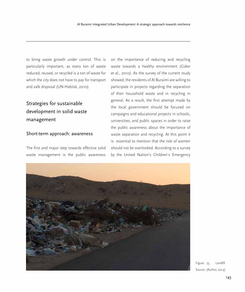
143
Al Buraimi Integrated Urban Development: A strategic approach towards resilience
to bring waste growth under control. This is
particularly important, as every ton of waste
reduced, reused, or recycled is a ton of waste for
which the city does not have to pay for transport
and safe disposal (UN-Habitat, 2010).
Strategies for sustainable
development in solid waste
management
Short-term approach: awareness
The first and major step towards effective solid
waste management is the public awareness
on the importance of reducing and recycling
waste towards a healthy environment (Coker
et al., 2010). As the survey of the current study
showed, the residents of Al Buraimi are willing to
participate in projects regarding the separation
of their household waste and in recycling in
general. As a result, the first attempt made by
the local government should be focused on
campaigns and educational projects in schools,
universities, and public spaces in order to raise
the public awareness about the importance of
waste separation and recycling. At this point it
is essential to mention that the role of women
should not be overlooked. According to a survey
by the United Nation’s Children’s Emergency
Figure 55. Landfill
Source: (Author, 2014)

144
Part 2.3 Infrastructure
Box 16. Community survey on solid waste management
A survey was carried out with questions that directly referred to the solid waste
management of the city. Almost 95% of the people said that an improvement in
the solid waste management is needed for their city. 56% responded positively
that they know and understand the meaning of composting. In the next question
regarding recycling, the 80% answered that they know this term. In addition to
that question, people were questioned if they would be willing to separate their
solid waste in order to help a recycling program to work. Almost the 72% said
“yes” whereas the 14% answered negatively. Furthermore, people were asked
if they would be willing to pay for the pickup of these recycling materials from
their houses and the 49% responded positively. Moreover, almost the 60% of
the people would like to participate in a program to compost food. The final
question was if people would participate in a program to return the plastic
bottles to the stores if they were paid for every bottle that they would return.
Almost the 78% answered positively.
Fund (UNICEF), development projects that did
not involve women failed to accomplish their
objectives.
On the same level, the prevention and the
minimization of solid waste is the most efficient
way of reducing the impacts on the environment,
as even the most efficient recycling of waste uses
resources and has impacts on the environment
(Salhofer et al., 2010). For that reason, the
campaigns in raising public awareness should
also focus on informing the people about the
importance of reducing the waste they produce.
Medium-term approach
Besides people’s eagerness to accept future
plans regarding the improvement of solid waste
management of the city and their participation
to it, the adequate equipment and vehicles
must be provided. According to Nilsson (2011),
the collection and the transport of waste from
the source to the treatment or disposal site
involve a lot of different equipment: bins and
containers, collection vehicles, routes, and an
efficient schedule for collection. Moreover, an
adequate numbers of bins should be distributed
throughout the whole city, according to the

145
Al Buraimi Integrated Urban Development: A strategic approach towards resilience
Figure 56. School
children educated in
recycling programmes
(Source: UN-Habitat,
2010)
needs of each specific area. Where the area has
higher density, a greater number of bins must
be provided to cover the residents’ needs. In
addition, those bins that will be distributed in
the city must be differentiated. There should be
bins only for paper, bins for plastic, and bins for
general waste.
Furthermore, bins or containers for the
collection of glass should be provided. Here,
there is the option that these bins are not
provided to the whole city, but larger containers
can be placed in specific spots so that people
could visit often and dispose of their glass for
recycling. These spots could be outside or near
from the supermarkets or the shopping mall or
even in some central areas in the city.
Moreover, the municipality can provide people
with different waste bags so that people can
be more motivated to separate their waste and
dispose of it in the appropriate bin.
Secondly, alongside with this equipment,
appropriate and adequate waste collection
vehicles should be provided in order to collect
all the waste from the city. These vehicles should
be differentiated according to the waste they will

146
Part 2.3 Infrastructure
collect, for plastic, paper, glass, and common
waste. Also, there could be different vehicles
regarding their size, small pick-up trucks,
medium and big, in order to serve different
parts of the city. In addition, the important
factors in the whole collection management are
the frequency of collection of solid waste, the
route planning for the vehicles, and the crew
size and truck capacity, as mentioned above.
The frequency of collection will be planned
according to the needs of the city and each area.
In order for that system to be successful the
participation of the people is required. Even
if this equipment and the vehicles exist and
operate in a very sufficient way, nothing will
change and improve if people do not separate
their waste and do not use the equipment that is
provided to do so appropriately.
Long-term approach
As was previously mentioned in the analysis
above, the existing landfill of the city is facing
problems. It is very close to the residential area
and the authorities are planning to close it down
and open a new one that will adhere to all the
regulations. It is very important to mention here
that the management of a landfill does not stop
after the termination of waste acceptance, but it
needs some provisions regarding the aftermath
before it can be retired (Scharff, 2011).
In addition, for a new landfill there are planning,
siting, and design procedures that should be
taken into consideration; these are complex
processes involving environmental issues and
technical features (Raga and Cossu, 2011).
However, except for good siting and design, a
successful landfill requires effective operation
and monitoring throughout its lifetime in order
for it to work properly. Technical equipment and
monitoring of the performance of the landfill are
required in order that a landfill be characterized
as successful and environmentally safe (Berge
et al., 2011). In addition, in the planning and
designing of a landfill it is very important to
understand the environmental impacts that
must be avoided, and that a modern landfill is
able to avoid these impacts (Christensen et al.,
2011).
As a result, a new landfill is highly necessary for
the planning and the design of the city, and at
the same time the safe termination of the use
of the current one. The current landfill, after
the termination of its use, can be used as a
collection and storing place for all the recyclable
waste that the city will produce and dispose of,
before the planning and the creation of different
recycling facilities that will accept the recyclable
waste and will treat them accordingly. This is the
next step for the improvement of solid waste
147
Al Buraimi Integrated Urban Development: A strategic approach towards resilience
management. New facilities are required that
will receive and process the recyclable materials.
It is clear that in order to create these recycling
centres adequate funding is needed from the
government. But this is a necessary step towards
the improvement of the solid waste management
for the city. Nilsson and Christensen (2011) give
the examples of a collection centre in Herning
and one in Copenhagen (both in Denmark),
where the amount of residential waste that
is being landfilled after treatment, is less than
4 percent. As a result, the life of the landfill is
extended and also the monitoring and operating
costs are reduced. In which case, funding that is
needed here will be covered in the long-term by
the positive effects of the new management and
the new facilities.
These examples show how efficient recycling
centres can be and the positive effects that
have come from an environmental point of
view, as well as from an economic one and for
unemployment or creating job opportunities.
An additional step for the improvement of
solid waste management concerns the laws
and the regulations. This step falls between a
medium- and a long-term plan, and the need
for the current laws and regulations review,
reformulation of the policies, as well as their
enforcement is essential. This procedure can
be done in more than one step and during the
different stages of the new plans. It could also be
done after the full operation of the new facilities
and of the whole network. Anyhow, new laws
and regulations are essential for the function
of any new system or for any improvement in
current state of solid waste management.
Wastewater management
The wastewater collection in the city of Al
Buraimi is done in two different ways. There
is the current sewage system network, which
covers approximately the 30-35 per cent of the
city, and the septic tanks that are used in the
rest of the city. The sewage system network is
connected directly to the wastewater treatment
plant, whereas the wastewater from the septic
tanks is collected and carried to the treatment
plant by privately owned trucks. The plans for the
sewage network and its increase of connections
throughout the city are considered to be big-
scale plans, a five-year plan (MRMWR, personal
communication, September 23, 2014). On the
other hand, any plans or proposals to increase
this network, conflicts with the fact that the city
is very scattered and of very low density. The
government is reluctant to allocate the amount
of money that is needed for this development
(MECA, personal communication, September
28, 2014).

148
Part 2.3 Infrastructure
Sewage Treatment Plant
The current sewage network consists of 3000
lines that are connected to the main network,
and 5300 household pipes that are connected
to these lines. This covers 35%of the city. The
new treatment plant, which is not far from the
city (approximately one kilometre), can receive
up to 3000 cubic meters of wastewater per day.
Out of this amount of wastewater, the treatment
plant is capable of producing around 400 to 500
cubic meters per day of clean water, which can
be used for irrigation purposes. Trucks from the
treatment plant distribute this treated water to
the irrigation sites. The only direct connection
from the treatment plant through a pipeline goes
out to the big city park. This sewage treatment
plant (STP) consists of two lift stations, one
pump station, and the actual site of the plant
(Wastewater department of MRMWR, personal
communication, October 2, 2014).
Inside this treatment plant is also a
microbiology laboratory where the wastewater
and the treated water are tested throughout the
whole procedure. The laboratory is adequately
equipped. The results from the Microbiology
Laboratory and the Water Quality Laboratory
specify that the samples of treated wastewater
are classified into Group A and therefore the
treated wastewater can be used for irrigation
purposes. For the time being, this treated water
is carried out of the treatment plant with trucks
that delivered it directly to the irrigation sites.
The sites though that receive this treated water
are only trees alongside the streets or in the park,
but not public spaces with grass that people
use. These green spaces with grass are irrigated
with fresh water. There is no clear reason of
why this is happening, as the certificates from
the laboratories specify that the treated water is
classified, as mentioned above, as Group A and
is completely safe and odourless. The reason
might be cultural, as people do not accept
sitting on grass that is being irrigated with
treated wastewater (Wastewater department of
MRMWR, personal communication, October 2,
2014).
Furthermore, further away from the city, there is
a former treatment plant, which receives daily
around 2000 M3 but delivers only around 50 M3/
day of treated wastewater and not in the same
quality as the new treatment plant does. Hence,
there are plans at the moment to increase the
capacity of the new treatment plant in order
to be able to receive also the wastewater that
the old plant receives daily. As a result the old
plant that is of lower standards will not be
needed anymore and it will be finally closed.
Nevertheless, there are currently construction
works taking place in the new plant in order to
increase its capacity (Wastewater department of
MRMWR, personal communication, 2014).
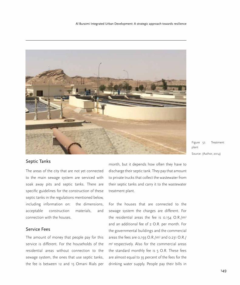
149
Al Buraimi Integrated Urban Development: A strategic approach towards resilience
Septic Tanks
The areas of the city that are not yet connected
to the main sewage system are serviced with
soak away pits and septic tanks. There are
specific guidelines for the construction of these
septic tanks in the regulations mentioned below,
including information on: the dimensions,
acceptable construction materials, and
connection with the houses.
Service Fees
The amount of money that people pay for this
service is different. For the households of the
residential areas without connection to the
sewage system, the ones that use septic tanks,
the fee is between 12 and 15 Omani Rials per
month, but it depends how often they have to
discharge their septic tank. They pay that amount
to private trucks that collect the wastewater from
their septic tanks and carry it to the wastewater
treatment plant.
For the houses that are connected to the
sewage system the charges are different. For
the residential areas the fee is 0.154 O.R./m3
and an additional fee of 2 O.R. per month. For
the governmental buildings and the commercial
areas the fees are 0,193 O.R./m3 and 0.231 O.R./
m3 respectively. Also for the commercial areas
the standard monthly fee is 5 O.R. These fees
are almost equal to 35 percent of the fees for the
drinking water supply. People pay their bills in
Figure 57. Treatment
plant
Source: (Author, 2014)

150
Part 2.3 Infrastructure
the Omani Investment and Finance Company
(OIFC) as they also do for their water bills
(Wastewater department of MRMWR, personal
communication, October 2, 2014).
Strategies for sustainable
development in wastewater
management
Inadequate provision of water and sanitation
affects hundreds of millions of people in small
urban centres. It is often assumed that it is
more difficult to support good provision of
water and sanitation in small urban centres than
in large cities due to weaker local governments,
fewer economies of scale for infrastructure
and management, and less capacity to pay.
Nevertheless, safe access for everyone is needed
to ensure the safe disposal of human excreta and
adequate wastewater treatment management.
The health and timesaving benefits that come
from good provision for water and sanitation
are well known through different examples from
around the world (McGregor, 2005).
It is essential for the government and the local
authorities to extend the main network across
the city so that every area and every new block of
houses is capable of connecting to that network
in the coming years.
Moreover, a strong advantage of the city of Al
Buraimi is the new wastewater treatment plant.
It is considered to be a modern treatment plant
that can treat wastewater and produce clean
water of good quality. The authorities at the
moment are working towards the expansion
of the new treatment plant in order to stop
using the old one, and to eventually close it
down. It is clear that these are long-term goals,
but it is something that has to be planned
and it is important that the procedures for its
implementation to begin as soon as possible.
Secondly, the issue that must be assessed is
the potential reuse of the treated wastewater
from the treatment plant. The primary problems
associated with reusing insufficiently treated
wastewater are the inherent health risks from
wastewater containing bacteria and viruses
(Sammis et al., 2001). The regulatory practices
and the necessary institutional framework
on both national and local levels need to be
reviewed (Raschid-Sally et al., 2001). In the case
of Al Buraimi, the treated wastewater, even if it
is considered to be of good quality according to
laboratories that check it daily, it is being used
only for irrigation purposes of urban greenery.
An action plan from the government must be
carried out, including regulations and criteria
for the water reuse and the implementation
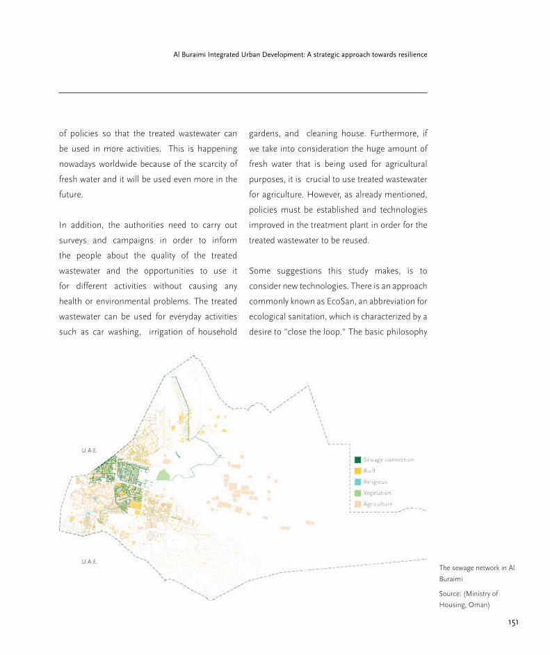
151
Al Buraimi Integrated Urban Development: A strategic approach towards resilience
The sewage network in Al
Buraimi
Source: (Ministry of
Housing, Oman)
of policies so that the treated wastewater can
be used in more activities. This is happening
nowadays worldwide because of the scarcity of
fresh water and it will be used even more in the
future.
In addition, the authorities need to carry out
surveys and campaigns in order to inform
the people about the quality of the treated
wastewater and the opportunities to use it
for different activities without causing any
health or environmental problems. The treated
wastewater can be used for everyday activities
such as car washing, irrigation of household
gardens, and cleaning house. Furthermore, if
we take into consideration the huge amount of
fresh water that is being used for agricultural
purposes, it is crucial to use treated wastewater
for agriculture. However, as already mentioned,
policies must be established and technologies
improved in the treatment plant in order for the
treated wastewater to be reused.
Some suggestions this study makes, is to
consider new technologies. There is an approach
commonly known as EcoSan, an abbreviation for
ecological sanitation, which is characterized by a
desire to "close the loop." The basic philosophy
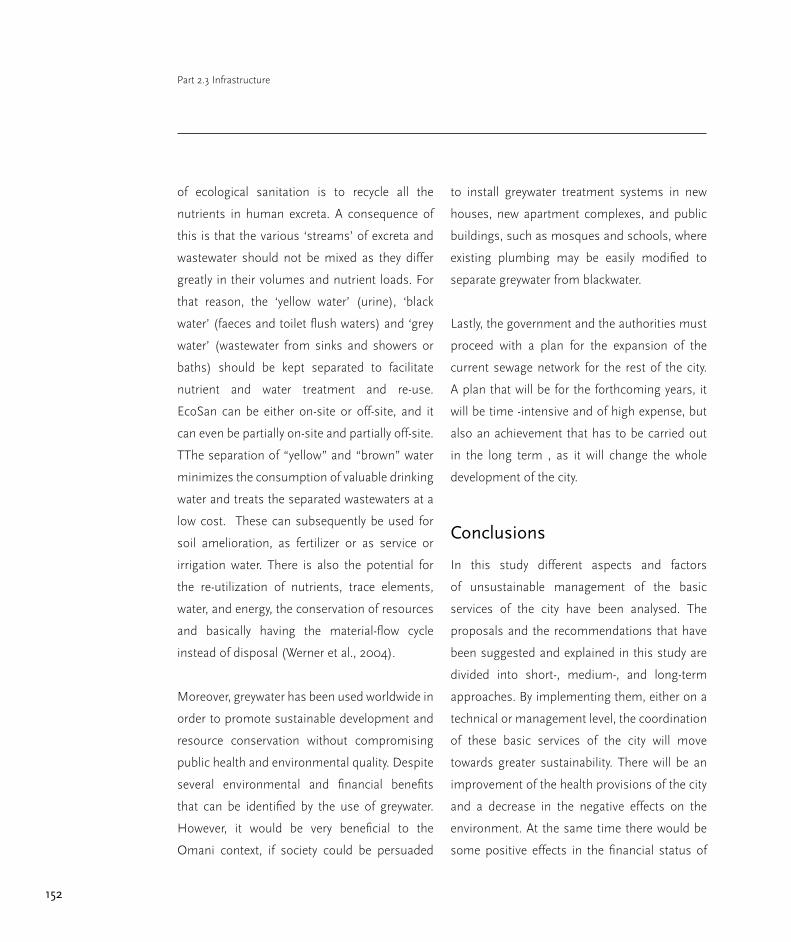
152
Part 2.3 Infrastructure
of ecological sanitation is to recycle all the
nutrients in human excreta. A consequence of
this is that the various ‘streams’ of excreta and
wastewater should not be mixed as they differ
greatly in their volumes and nutrient loads. For
that reason, the ‘yellow water’ (urine), ‘black
water’ (faeces and toilet flush waters) and ‘grey
water’ (wastewater from sinks and showers or
baths) should be kept separated to facilitate
nutrient and water treatment and re-use.
EcoSan can be either on-site or off-site, and it
can even be partially on-site and partially off-site.
TThe separation of “yellow” and “brown” water
minimizes the consumption of valuable drinking
water and treats the separated wastewaters at a
low cost. These can subsequently be used for
soil amelioration, as fertilizer or as service or
irrigation water. There is also the potential for
the re-utilization of nutrients, trace elements,
water, and energy, the conservation of resources
and basically having the material-flow cycle
instead of disposal (Werner et al., 2004).
Moreover, greywater has been used worldwide in
order to promote sustainable development and
resource conservation without compromising
public health and environmental quality. Despite
several environmental and financial benefits
that can be identified by the use of greywater.
However, it would be very beneficial to the
Omani context, if society could be persuaded
to install greywater treatment systems in new
houses, new apartment complexes, and public
buildings, such as mosques and schools, where
existing plumbing may be easily modified to
separate greywater from blackwater.
Lastly, the government and the authorities must
proceed with a plan for the expansion of the
current sewage network for the rest of the city.
A plan that will be for the forthcoming years, it
will be time -intensive and of high expense, but
also an achievement that has to be carried out
in the long term , as it will change the whole
development of the city.
Conclusions
In this study different aspects and factors
of unsustainable management of the basic
services of the city have been analysed. The
proposals and the recommendations that have
been suggested and explained in this study are
divided into short-, medium-, and long-term
approaches. By implementing them, either on a
technical or management level, the coordination
of these basic services of the city will move
towards greater sustainability. There will be an
improvement of the health provisions of the city
and a decrease in the negative effects on the
environment. At the same time there would be
some positive effects in the financial status of

153
Al Buraimi Integrated Urban Development: A strategic approach towards resilience
Box 17. Community survey on wastewater management
In the questions that were focused to the wastewater management sector
almost the 90% of the answers pointed out that an improvement in the whole
system and in the management of the wastewater is needed. Furthermore, in the
question regarding in what way do residents discharge their wastewater, almost
25% answered through the main sewage network, the 21% answered through
a septic tank and the remaining 54% did not give an answer or answered by
“Do not know”. In addition to this and likely related is the response that the
56% of the people questioned did not know how much money they spend on
their wastewater disposal. Less than the half answered with an average of 25
Omani Rials per month. The conclusions that can be made from the survey
is that maybe people are not familiar with the way their households dispose
the wastewater but they have a basic knowledge and an opinion that the whole
system needs to be improved.
the city in the long-term, as well as employment
benefits.
In addition, by investing in further research in
order to find more solutions (especially technical
ones), the city will manage to reach a point where
it can be considered as a sustainable developing
city. By applying these changes, the city will
“meet its needs without compromising the
ability of future generations to meet their own
needs,” as defined by the World Commission on
Environment and Development. It will become a
sustainable city as Haughton and Hunter (1994)
described as “one in which its people endeavour
to improve their natural, built, and cultural
environments.”
A report from the Secretary-General’s High-
Level Panel of Eminent Persons on the Post-
2015 Development Agenda (United Nations,
2013), discussed the current millennium
development goals, known as MDGs, and the

154
Part 2.3 Infrastructure
changes that are likely to take place through
2030. The recommendations of the current
study are working towards the direction of the
post-2015 targets regarding the access to water
and sanitation that are: a) to provide universal
access to safe drinking water at home and in
schools, b) to end open defecation and ensure
universal access to sanitation at school and
work, and increase access to sanitation at home,
c) to bring freshwater withdrawals in line with
supply, and d) to recycle or treat all municipal
and industrial wastewater prior to discharge
(United Nations, 2013).
After the analysis of these three basic services, it
was revealed that the most challenging is solid
waste management. The fresh water supply is at
a very strong level as the scarcity of water in the
whole MENA region is a problem from many
years ago and the government has focused
already on this issue. The sewage network
already exists, and plans for its extension in
order to cover more parts of the city are already
being discussed. In addition, there is a new
wastewater treatment plant with high technology
but also facing the challenge of not being able to
receive all the wastewater in the near future of a
rapidly growing city. In contrast to this, there is
the solid waste management area that lacks any
sustainable improvements or developments.
Recycling projects and centres are totally absent
and the current landfill causes a lot of problems
in the environment and for the health of the
residents. This service is the most challenging of
all in moving towards sustainable development.
Finally, the most important tools in a
development scheme are those employed in
the monitoring of the process, the collection
of data and their evaluation. The need to
improve access to reliable territorial data was
identified during the fieldwork in the city of Al
Buraimi, an improvement that would help in
the development of strategies to implement
the recommendations of the current thesis
and also of any future research. At the same
time, it would help to monitor and evaluate the
results and impacts of these implementations.
Moreover, monitoring of the SWOT analysis is
valuable in order to identify whether the goals
are being met or not. For these reasons, the
current mechanism that already exists in the city
of Al Buraimi, and in the whole country, should
be improved in order to obtain local and reliable
data, and also to monitor and evaluate any
future implementation.

155
Al Buraimi Integrated Urban Development: A strategic approach towards resilience
References
Abdel-Rahman, H. A. & Abdel-Magid, I. M.
(1993) Water Conservation in Oman. Water
International Vol. 18 (2), pp. 95–102.
Al Badi, A. H. et al. (2011) Sustainable energy
usage in Oman-Opportunities and barriers.
Renewable and Sustainable Energy Reviews.
Vol. 15 (8), pp. 3780–3788.
Al Gharibi, H. (2013) Urban Growth from
Patchwork to Sustainability Case Study: Muscat.
PhD Dissertation in Technische Universität
Berlin.
Angelakis, A. N. et al. (1999) The status of
wastewater reuse practice in the Mediterranean
basin: need for guidelines. Water Research Vol.
33 (10), pp. 2201–2217.
Awopetu, M. S. et al. (2012) Residents’
Knowledge Of Waste Reduction, Reusing And
Recycling In Makurdi Metropolis, Nigeria. pp.
1–9.
Bahri, A. (2009) Managing the Other Side of
the Water Cycle: Making Wastewater an Asset.
Global Water Partnership Technical Committee,
TEC Background Papers No. 13, Mölnlycke,
Sweden
Berge, N. D. et al. (2011) Landfilling: Operation
and Monitoring, in Solid Waste Technology &
Management. Blackwell Publishing Ltd. pp.
914–931
Bixio, D. et al. (2006) Wastewater reuse in
Europe. Desalination. Vol. 187 (1-3), pp. 89–101.
Christensen, T. H. et al. (2011) Landfilling:
Environmental Issues, in Solid Waste
Technology & Management. Blackwell
Publishing Ltd. pp. 695–708
Christensen, T. H. (ed.) (2011a) Solid Waste
Technology & Management. Vol. 2, 2 vols.
Blackwell Publishing Ltd.
Christensen, T. H. (ed.) (2011b) Solid Waste
Technology & Management. Vol. 1, 2 vols.
Blackwell Publishing Ltd.
Coker, A. O. et al. (2010) Assessment of
residents’ awareness, attitude and participation
in Solid Waste Management in Makurdi
Metropolis, Nigeria. International Journal of
Engineering Vol. 4(1). pp. 39–45.
Davoudi, S et al. (2009) Planning for Climate
Change: Strategies for Mitigation and
Adaptation for Spatial Planners. Earthscan
Publishing, London.

156
Part 2.3 Infrastructure
DeLoG et al. (2014) How to localize targets
and indicators of the Post- 2015 agenda. The
Development Partners Working Group on
Decentralisation & Local Governance.
Devuyst, D. (2001), How Green Is The
City? : Sustainability Assessment and The
Management of Urban Environments,
Columbia University Press.
FAO-Aquastat (2008) Oman UN-Water Country
Brief. Available: http://www.unwater.org/
publications [accessed 5 Dec 2014]
Ghneim, A. (2010) Wastewater Reuse and
Management in the Middle East and North
Africa: A Case Study of Jordan. Dissertation in
Technische Universität Berlin.
Grobbelaar, S. (2012) Urban Patterns for a
Green Economy: Leveraging density. UN-
Habitat.
Haughton, G. & Hunter, C. (1994) Sustainable
Cities. Jessica Kingsley Publishers and Regional
Studies Association, London.
Jafari, N. (2008) Water Shortages in The Middle
East. The First International Conference on
Water Resources and Climate Change in MENA
Region, Muscat, Oman.
Levine, A. D. & Asano, T. (2004) Peer reviewed:
recovering sustainable water from wastewater.
Environmental science & technology. Vol. 38
(11), pp. 201A–208A.
McGregor, D. F. (2005) The peri-urban
interface: approaches to sustainable natural
and human resource use. UN-Habitat.
Ministry of Regional Municipalities and Water
Resources (2008) Water Resources in Oman.
Moreira, R. J. (2000) Críticas ambientalistas a
Revolução Verde. Revista Estudos Sociedade e
Agricultura, pp.39-52
Moughtin, C. & Shirl, P. (2005). Urban Design:
Green Dimension. Architectural Press.
Nilsson, P. (2011) Waste Collection: Equipment
and Vehicles, in Solid Waste Technology &
Management. Blackwell Publishing Ltd. pp.
253–276
Nilsson, P. & Christensen, T. H. (2011) Waste
Collection: Systems and Organization, in Solid
Waste Technology & Management. Blackwell
Publishing Ltd. pp. 277–295
Popov, V. et al. (2012) Waste Management and
the Environment VI. WIT Press.
157
Al Buraimi Integrated Urban Development: A strategic approach towards resilience
Prathapar, S. A. et al. (2005) Overcoming
constraints in treated greywater reuse in Oman.
Desalination. Vol. 186 (1-3), pp.177–186
Public Authority for Electricity and Water (2013)
Annual Report 2013. Available: www.paew.gov.
om. [accessed 4 Dec 2014]
Raga, R. & Cossu, R. (2011) Landfilling:
Planning, Siting and Design, in Solid Waste
Technology & Management. Blackwell
Publishing Ltd. pp. 898–913
Ragette, F. (2012) Traditional Domestic
Architecture of the Arab Region. Third,
unrevised edition. American University of
Sharjah
Raschid-Sally et al. (2001) Rethinking Urban
Wastewater Re-use: Opportunities and
Challenges. Proceedings of Frontiers in
Urban Water Management: Deadlock or
Hope? Symposium of UNESCO International
Hydrological Program, 18-20 June 2001
Marseille, France
Richardson, N.H. (1989) Land Use Planning
and Sustainable Development in Canada.
Canadian Environmental Advisory Council,
Ottawa
Salhofer, S. et al. (2010) Waste Prevention and
Minimization: Concepts, Strategies and Means,
in Solid Waste Technology & Management.
John Wiley & Sons, Ltd. pp. 183–192
Samar Damluji, S. (1998) The Architecture of
Oman. London: Garnet Publishing
Sammis, T. et al. (2001) Sewage Effluent
Discharge Regulations for Irrigation
Development in the Middle East Region,
Middle East Countries Standards Site for
Sewage Treatment and Water Reuse
Scharff, H. (2011) Landfill Closure, Aftercare
and Final Use, in Solid Waste Technology &
Management. Blackwell Publishing Ltd. pp.
932–947
Sewilam, H. & Nacken, H. (2008) TOTWAT: An
Interdisciplinary Water Management Training
Program in the MENA Region. The first
international conference on water resources
and climate change in the MENA region,
Muscat, Oman
UN-Habitat (2010) Solid Waste Management
in the World’s Cities. Earthscan Publishing,
London, Washington DC.
United Nations (2013) A New Global
158
Part 2.3 Infrastructure
Partnership: Eradicate Poverty and Transform
Economies through Sustainable Development.
United Nations Publication
Werner, C. et al. (2004) Ecosan-Introduction
of Closed-Loop Approaches in Wastewater
Management and Sanitation, A Supra-Regional
GTZ-Project, in Water in the Middle East
and in North Africa. Springer. pp. 263–273.
Available: http://link.springer.com/chapt
er/10.1007/978-3-662-10866-6_22 [accessed 10
Dec 2014].
World Commission on Environment and
Development (1987) Our Common Future,
Oxford University Press, New York
Zekri, S. et al. (2012) Damage cost of drying of
Aflaj in the Sultanate of Oman. Sultan Qaboos
University Research Journal-Agricultural and
Marine Sciences.

159
Al Buraimi Integrated Urban Development: A strategic approach towards resilience

Part 2.4 Housing & urban designFlorencia Carvajal
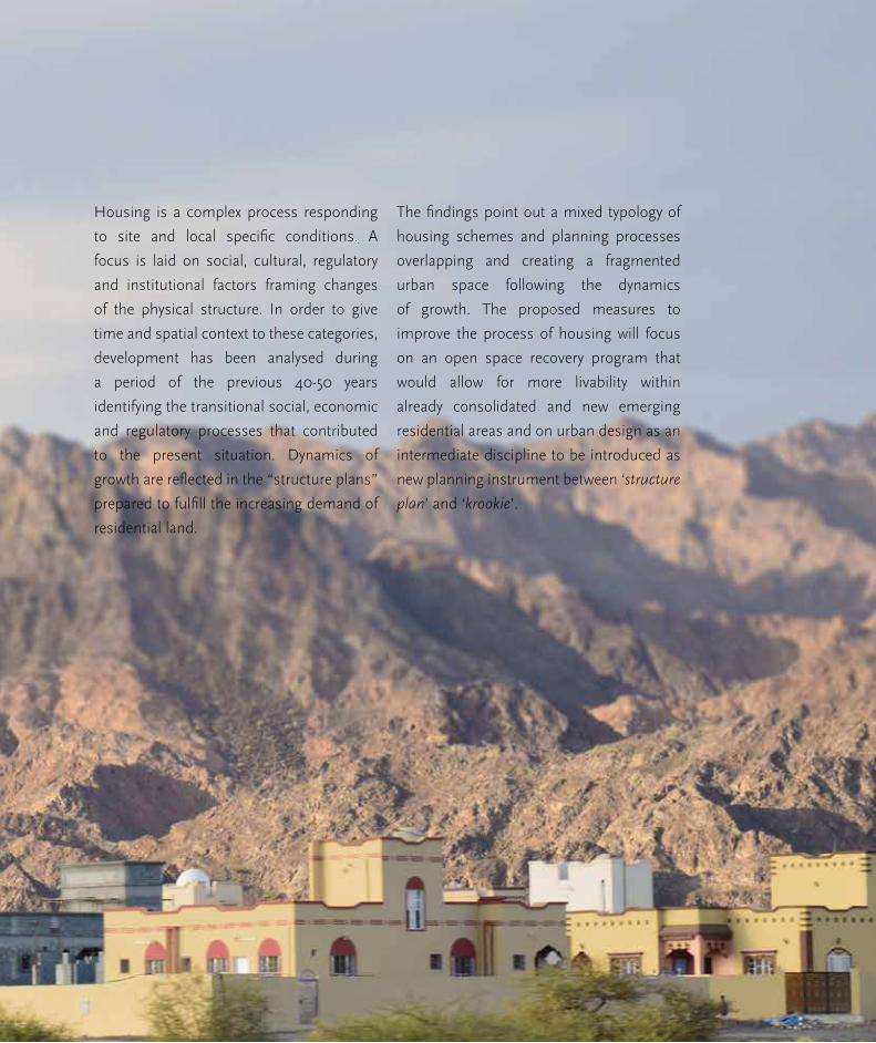
Housing is a complex process responding
to site and local specific conditions. A
focus is laid on social, cultural, regulatory
and institutional factors framing changes
of the physical structure. In order to give
time and spatial context to these categories,
development has been analysed during
a period of the previous 40-50 years
identifying the transitional social, economic
and regulatory processes that contributed
to the present situation. Dynamics of
growth are reflected in the “structure plans”
prepared to fulfill the increasing demand of
residential land.
The findings point out a mixed typology of
housing schemes and planning processes
overlapping and creating a fragmented
urban space following the dynamics
of growth. The proposed measures to
improve the process of housing will focus
on an open space recovery program that
would allow for more livability within
already consolidated and new emerging
residential areas and on urban design as an
intermediate discipline to be introduced as
new planning instrument between ‘structure
plan’ and ‘krookie’.

162
Part 2.4 Housing and Urban Design
Assessment of the current
state of housing
Introduction
This chapter summarizes Oman’s structural
changes, which influenced the housing sector
during the period of 1970 to 2014. There is a
focus on changes in contextual elements as
on regulatory and social aspects which have
resulted from the mechanisms the Sultanate
adopted to establish a nation-wide government
to guide and control urban issues in Oman.
Land regulation and allocation
The discovery of oil and natural gas in the
1960’s marked the economic growth process,
that went along with infrastructure expansion,
mainly improving the road network and it was
the starting point for urbanisation. The year
of 1970 had set the most crucial turning point
in the history of Oman, considered as the
beginning of the ‘modern Omani state’. This
implied the intention to establish basic rights
and duties in an equitable manner. It required
adjusting the accustomed tribal management
of the territory to a single centralized national
government. Since 1970 providing land tenure
to the Omanis has been considered crucial to
development policy.
The first land law (Royal Decree No. 5/80),
announced that all land belonged to the state,
unless possession was proven as owned or
inherited (by providing documents stating
otherwise from the local sheikh or legal courts)
prior to the first of January, 1970. The land law
Royal Decree No 81/84 announced the right of
every male Omani citizen to have a residential
plot granted from the government to him.
The strategy of land allotment required the
creation of the Department of Lands in 1975.
This was to manage the new progressive
urban policies, along with the execution of
operations for urban development purposes
being established in the first Royal Decree, No.
26/1975. These operations went from planning
to preparing, coordinating, distributing, defining,
registering and settling all land issues. The Land
Affairs Committee was formed to regulate the
claiming of lands. Its members were appointed
sheikhs from the Department of Lands for every
province (wilayat).
Previous page:
Housing projects in the
outskirts
Source: (Salcedo, 2014)

163
Al Buraimi Integrated Urban Development: A strategic approach towards resilience
Equal tenure rights for women
An important event in Oman, which determined
a change of pace for the planned expansion
of cities was women being given the right to
land in 2008 via Royal Decree No.(125/2008),
issued the 16th of November. Considering
the percentage of population, which women
represented in the country in 2012, twice as
much plots were required to accomplish the
equality decree. In addition, the sites to be
granted have increased to a minimum area of
600sqm; almost double the initial area. The
reason for this increase was due to the high
demand from the citizens requiring larger areas
to cope with their bigger internal living space,
as mentioned by the authority Head of Urban
Planning section in Al Buraimi, MOH.
Land allocation procedure
The process of land distribution began granting
benefits to a single plot of land (in the vicinity
of the place of birth or work), to male Omani
nationals after they had reached 21 years of
age. The time necessary to wait for the draw to
happen could not be determined, hence it was
strongly related to the number of applications.
The drawing system was proposed to achieve
transparency and fairness between the people,
in relation to the location within the city where
the plot was granted. To mark out the future
allotted plots for development, the MOH must
first survey, identify, measure, and record with
a specific nomenclature in the land record
document. Further steps needed to finish with
a physical house were not described as the
responsibility of the MOH. Neither was the
relationship to other infrastructure or basic
services needed for the plot. During that initial
time of implementation, after the lottery, the
people received a temporary contract which
would be switched to an ownership certificate
only after developing the site,
Priority is only given to the house as a legal unit
for every male Omani to manage the family and
perpetuate the societal system. The haphazard
results of the lottery sent the male Omanis to
possess land in remote areas of the city being
separated from their initial family. With the
progression of land allocation throughout the
country during the following years, in 1990
a strategic development effort with a 2020
planning vision came forward.

164
Part 2.4 Housing and Urban Design
Urban planning instruments –
structure plans compared
The zoning distribution which was once
traditionally handled by the local tribes in
response to its contextual needs is now in the
responsibility of the Supreme Committee for
Town Planning based in Muscat. Historical
data available from the MOH helps overview
the development and planning of designated
housing areas in Al Buraimi during the years of
1984 to 2014.
Action plan of 1984
The intention of the action plan was to provide
a broad view of the spatial organization of the
city's development, without presenting details.
The initial zoning categories were: residential,
commerce, industry, roads, services and
individual projects. Health and education were
established in the five year development plans
mentioned earlier. The existing settlements are
encompassed by short, medium and long time
planned roads combined with the electricity
network. Fortunately, there are no plans for road
building within the former villages of Hamasa,
Buraimi or Saara.
Figure 58. Action plan
1984
Source: (Ministry of
Housing 1984)

165
Al Buraimi Integrated Urban Development: A strategic approach towards resilience
An offset from the border is also set in this
plan, almost 2km at the furthest point, and the
intention is to fill the buffer space with housing.
The scale of this is not aligned with the existing
settlements, but rather to the scale of the
proposed new highways that will intersect the
city. Commerce is set along the planned road
connecting with Al Ain, across almost all Al
Buraimi.
In this plan, the intersection of highways is
marked as hierarchy points in the city and the
classification of blocks in the structure plan
is not set. Areas indicating future residential
character have not assigned in detail the number
of blocks they will contain, nor how they will be
distributed within the city.
The first land draw came into force in 1984
granting the Omanis plots ranging in size
from 320 to 350 square meters. According to
this year’s plan, the average number of plots
designated for future housing in the long term is
2600, located at the mentioned buffer area. The
short term plan's housing plots were already
complete in design but not yet constructed. The
medium term plan proposes 574 housing plots.
They corresponded mainly to the New Saara
neighborhood.
Figure 59. Structure
plan 1985
Source: (Ministry of
Housing 1985)

166
Part 2.4 Housing and Urban Design
Structure plan of 1985
In relation to the previous map, the structure
plan of 1985 provides more detailed
information on how the city will be structured
with its corresponding operations. However,
specifications are not provided in the plan due
to its focus and purpose. A specific grid can
already be recognized dividing the spaces the
main road infrastructure had left. Within those
areas the streets correspond to a medium road
hierarchy being less wide. Still, the plan does
not manage to establish roads at the dwelling
level, even though ‘Neighbourhood centres’ are
proposed; 6 in total. Regardless of this, they are
not detailed further. There is also a tendency to
repeat Al Buraimi’s main road pattern from the
previous year's action plan at the immediate
smaller scale, especially for the New Saara area.
This structure plan does not intend to design all
elements until its completion. 8 neighbourhoods
are identified and 2830 plots will be introduced;
totalling 95 hectares of expansion. Most of
them are intended for the area between the
international border and the main highway.
Several others are intended to settle within the
inner borders of the initial villages of the city,
at the north of the Oasis. New consolidated
service structures supply the residential needs
of New Saara and Al Khadara. The outline of the
Figure 60. Expansion
plan 1986-1996
Source: (Ministry of
Housing 1985)

167
Al Buraimi Integrated Urban Development: A strategic approach towards resilience
service areas correspond to the roads, whenever
they are attached to them. When not, the shape
still remains geometrical; however the reference
they follow are not easily distinguishable. The
layout does not intend to specify inner block
space or even neighbourhoods. The priority is
to determine the road network. This defines the
limits of the future buildable area needing buffer
zones or open spaces as sidewalks or setbacks.
Expansion plan 1986- 1996 & 1987-
1990
The figures shown correspond to the previous
official planning which determines the structure
of Al Buraimi nowadays. The performance
of the plans show the set development
prioritizing displacement within the city
by motorized vehicles, and not dividing or
distributing the terrain for a pedestrian scale.
The pattern of further expansion of the grid
eastwards establishes subdivisions within
designated neighbourhood areas. They continue
appearing disconnected among each other in
between areas for other uses, and all together
disconnected from the main hierarchy of roads.
An area of temporary housing is established
at the north of Al Khadra and more expansion
towards the east; two major areas designated
for residential growth. Yet there is no intention
to set a clear network, distributing from the
Figure 61. Expansion
plan 1987-1990
Source: (Ministry of
Housing 1985)

168
Part 2.4 Housing and Urban Design
main roads to the new subdivisions or existing
neighbourhood centres areas.
The arrangement of plots is noticeable
however, there is no clarity on whether they
are contained in a block or not. Areas to be
extensions of the city are shown by surrounding
new infrastructure networks. They have started
to be occupied with construction works which
disregard any potential future expansion or
design of secondary/ internal access roads or
public spaces to serve the area.
On an individual scale, foreign influence over
the residential buildings is observed on Al
Buraimi’s architecture. Also, privacy and security
characteristics remain a constant need.
Figure 62. Road
hierarchy and town access
according to structural
plan
Source: (Ministry
of Transport and
Communications, 2014)
Interpretation: Author,
2015.
The management of territory for the Governorate
occurs within the national level. This is organized
by the Supreme Committee for Planning. Within
this framework the MOH structures regional
plans for the SCP to draw Town Structure Plans,
which will be implemented in Al Buraimi by two
lateral partners at the local level: the Ministry of
Transport and Communications and Ministry of
Regional Municipalities and Water Resources,
MRMWR.
Regarding road design: the main road
connection and town access strategy prevents
direct traffic contact with residential or quiet
areas. Towns and core areas are connected
inside by internal and secondary roads with no
physical link to upper road levels typologies.

169
Al Buraimi Integrated Urban Development: A strategic approach towards resilience
Figure 63. Current
Al Buraimi map used for
planning
This map is used by
different Ministry
branches in Al Buraimi
that are responsible
for development and
planning.
Source: (Ministry of
Housing, Modified by
author, 2014)

170
Part 2.4 Housing and Urban Design
Finding: Dual reality – dual dynamics
of develoment
The development of the city, triggered mainly by
land policies in Oman and guided by the main
road network, generated ambitious perspective
plans of vast lands, marked with plots and
functions even before the need for them had
appeared.
Al Buraimi city shape is based on two realities.
The first refers to the current city and its
occupied area, driven by the needs and priorities
of the individual plot owners. It is up to them to
decide about when to built up their lands.
The second reality refers to the designed areas
made up of marked plots that have not been
granted yet or have been allocated but not yet
developed. This reality is driven by demand and
supply policy following the land law.
As it is visible in the figures on the previous
page and above, there is fragmentation between
the pace of development and that of planning.
Zoning planning of the country was designated
as responsibility of the Supreme Committee
for Town Planning. The new land management
bodies have been under the supervision of
the Consultative Council (Majlis al- Shura)
Figure 64. Construct-
ed Al Buraimi
Latest built situation
Source: (Ministry of
Housing 2014/ Author,
2014)
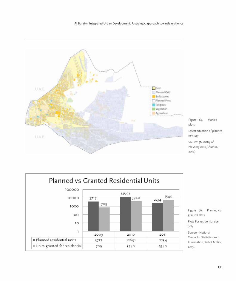
171
Al Buraimi Integrated Urban Development: A strategic approach towards resilience
Figure 65. Marked
plots
Latest situation of planned
territory
Source: (Ministry of
Housing 2014/ Author,
2014)
Figure 66. Planned vs
granted plots
Plots For residential use
only
Source: (National
Center for Statistics and
Information, 2014/ Author,
2015)

172
Part 2.4 Housing and Urban Design
since 1991, when it was created to serve as a
channel of information between the Omanis
and the governmental ministries. Their role
is to review works on social, environmental
and economic broad development projects,
with residential land designation being a part
of this. This council operates centrally from
Muscat. All the established departments and
ministries are under the authority of the Sultan.
The Department of Lands continued evolving in
scope and name until becoming the MOH in
1985.
Emerging socio-spatial disparities
The border closing in 2014 was a governmental
strategy to force Al Buraimi’s own development
instead of depending on Al Ain’s. One month
before Buraimi obtained its autonomy from the
Ad Dhahirah Region by becoming a governorate,
two checkpoints were implemented and the
border was relocated 8 km to the east, around
Hilli, within the new governorate. One of the
first major shifts this caused was from people
interested in acquiring land for dwelling
purposes in Al Khadra (next to the border). They
were now looking at areas like New Saara to
Figure 67. Omani
and expat population in Al
Buraimi Governorate
Source: (National
Center for Statistics and
Information, 2014/ Author,
2014)

173
Al Buraimi Integrated Urban Development: A strategic approach towards resilience
Figure 68. Chronologi-
cal division scheme
Marked in squares: Al
Khadra and Al Guraifa
Source: (Author, 2015)
the east. The new limitations for movement to
Al Ain created the conditions for the citizens to
start considering relocation to the new planned
schemes of previous years.
Expat population
The expatriates are segregated in the city, living
adjacent to or at the rear of the commerce
areas where they are employed. In Al Buraimi
commercial clusters are located mainly within
the centre. Despite the lack of specific data
that would indicate the provenance of the
expatriates, during the on-site research, it was
noticed that the great majority of the work force
of the city does not come from GCC nationals.

174
Part 2.4 Housing and Urban Design
Figure 69. Expat on
his way home
Source: (Author, 2015)
175
Al Buraimi Integrated Urban Development: A strategic approach towards resilience
They mostly come from the Indian subcontinent,
as well as other central Asian countries and
Middle Eastern. This creates a gap among the
standards of dwelling conditions in the city,
and it is reflected in the immediate areas in
which they settle. Besides this, foreigners are
not allowed to buy land freely in Oman. As
a result of this, the only option for them is to
rent; either houses or empty terrain. However,
groups tend to share the accommodation in
the traditional quarters; hence the areas have
been left by the Omani owners who moved
to better-off new constructions with modern
improvements as electricity, water and drainage.
The expatriates split the costs of rent which
result in overcrowding. This has the potential to
lead to slum like conditions, influencing the way
in which the city operates.
Box 18. Social aspects of housing
The MOH also includes a department in charge of social housing. There are four
ways the government addresses the need for the physical housing structure,
besides granting a plot of land to people. The first is by providing capital
for people to build on their own, with supervision of the MOH. Second, the
Department manages the process and dispenses the final product. Third, the
Department purchases the desired dwelling to provide and fourth, an interest
free loan (30,000 Omani Riyals) is awarded to the applicant. All the options
for aid apply for low-income nationals, defined to this day as someone earning
more than 300 but less than 500 Omani Riyals a month. This is verified after the
application is submitted. Information from the local authority of the Department
states in total there are between 200 - 300 applications each year for these
options. The process takes a year and the construction of the dwellings usually
takes 8 months.

176
Part 2.4 Housing and Urban Design
Finding: Change in urban morphology
The growth of Al Buraimi until 1990 had not
boosted accordingly to the proposed plans in
order to require such extensive highways for city
delimitation causing a morphological turning
point. As a consequence of the land allocation
system, the built areas begin to appear unevenly
among the city. The loose scheme of plots
generates empty and large spaces whose
functions are undefined and interrupt the
continuous urban layout. Noticeable contrasts
exist between the compactness of the initial
settlements and the loose sprawl setting the
norm of the current settlements
No subdivision of land on a smaller scale is
found from the plots among each other. Or
from these to blocks, to neighbourhoods and
to its extensions which would fill the spaces
enclosed by roads connecting the city with the
country. Also gaps in the city morphology began
to appear as soon as the first proposed action
plan. Large gaps of unused land contradict the
initial settlement’s morphological structure.
The notion of periphery is set thoughtlessly
but as a consequence of surrounding the initial
settlements with roads.
Figure 70. Preffered
living areas
Source: (Ministry of
Housing 2014/ Author,
2015)

177
Al Buraimi Integrated Urban Development: A strategic approach towards resilience
Figure 71. Neighbour-
hoods in the outskirts
Figure 72. Neighbour-
hoods in the city centre
Figure 73. Neighbour-
hoods in the city centre 2
Source: (Author, 2014)
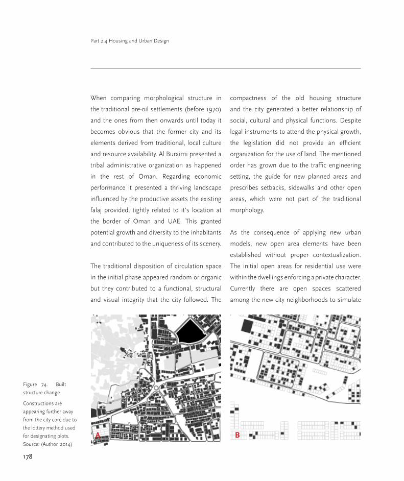
178
Part 2.4 Housing and Urban Design
Figure 74. Built
structure change
Constructions are
appearing further away
from the city core due to
the lottery method used
for designating plots.
Source: (Author, 2014)
When comparing morphological structure in
the traditional pre-oil settlements (before 1970)
and the ones from then onwards until today it
becomes obvious that the former city and its
elements derived from traditional, local culture
and resource availability. Al Buraimi presented a
tribal administrative organization as happened
in the rest of Oman. Regarding economic
performance it presented a thriving landscape
influenced by the productive assets the existing
falaj provided, tightly related to it’s location at
the border of Oman and UAE. This granted
potential growth and diversity to the inhabitants
and contributed to the uniqueness of its scenery.
The traditional disposition of circulation space
in the initial phase appeared random or organic
but they contributed to a functional, structural
and visual integrity that the city followed. The
compactness of the old housing structure
and the city generated a better relationship of
social, cultural and physical functions. Despite
legal instruments to attend the physical growth,
the legislation did not provide an efficient
organization for the use of land. The mentioned
order has grown due to the traffic engineering
setting, the guide for new planned areas and
prescribes setbacks, sidewalks and other open
areas, which were not part of the traditional
morphology.
As the consequence of applying new urban
models, new open area elements have been
established without proper contextualization.
The initial open areas for residential use were
within the dwellings enforcing a private character.
Currently there are open spaces scattered
among the new city neighborhoods to simulate
A B
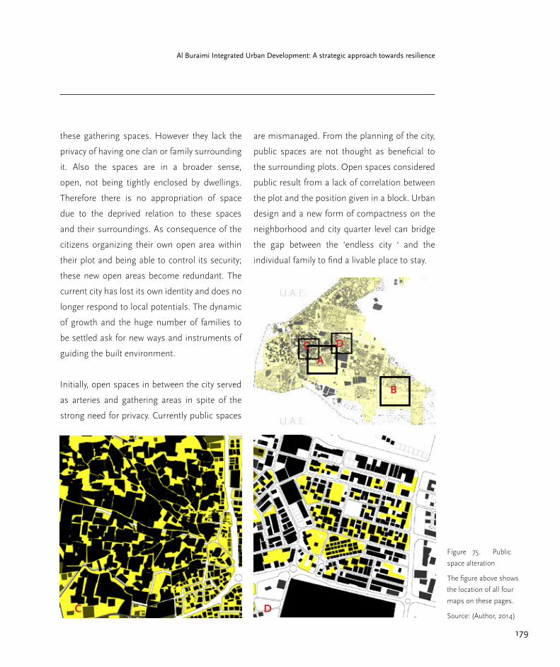
179
Al Buraimi Integrated Urban Development: A strategic approach towards resilience
Figure 75. Public
space alteration
The figure above shows
the location of all four
maps on these pages.
Source: (Author, 2014)
these gathering spaces. However they lack the
privacy of having one clan or family surrounding
it. Also the spaces are in a broader sense,
open, not being tightly enclosed by dwellings.
Therefore there is no appropriation of space
due to the deprived relation to these spaces
and their surroundings. As consequence of the
citizens organizing their own open area within
their plot and being able to control its security;
these new open areas become redundant. The
current city has lost its own identity and does no
longer respond to local potentials. The dynamic
of growth and the huge number of families to
be settled ask for new ways and instruments of
guiding the built environment.
Initially, open spaces in between the city served
as arteries and gathering areas in spite of the
strong need for privacy. Currently public spaces
are mismanaged. From the planning of the city,
public spaces are not thought as beneficial to
the surrounding plots. Open spaces considered
public result from a lack of correlation between
the plot and the position given in a block. Urban
design and a new form of compactness on the
neighborhood and city quarter level can bridge
the gap between the ‘endless city ‘ and the
individual family to find a livable place to stay.
A
B
C D
C D

180
Part 2.4 Housing and Urban Design
Regulations and building codes
Taking into account the standardized process of
plot lottery which began in 1984, there was a gap
of 14 years in which no consideration was given
to build homogeneity in the city. Al Buraimi was
accustomed to clustered spaces within the city,
designated to specific functions with a uniform
character. With the new expansion planning,
directions arranging the operations along road
infrastructure axes needed standards. They
intended to preserve the traditional Omani
features while combining modern ones in the
developing city. Nevertheless these permits
and certificates were only for the built elements
individually and not seen as a composition to
make up the city. This code is not the extension
of the urban plans linking both urban scales
from the city to its final built dwelling elements.
Traffic engineering sets the key for new
community planning, requiring setbacks and
other open areas to set large scale limits
between the network and the city.
The existing building code from the Municipality
to regulate the built environment of the city is
focused on the house unit Little is established
regarding its relation to the city context
surrounding it. As Article 58, section a) about
residential buildings establishes: “1 (. . .)
passages and corridors between two rows of
different residential units of width (1.50) meters
to a passage up to (15) meters long, if the length
exceeded that, then the width shall increase to a
maximum of (2.20) meters. It can be illustrated
in the adjacent figure.
This contributes to the second reality in which
there is a divergence from the real situation
in the city and the utilized plan in which the
MOH bases subsequent city planning, “2 A
main corridor in front of one row of different
residential units of width (1.40) meters for five
units, if the units exceeded this number, then
the width shall be increased by (5%) for every
additional unit provided that the maximum
width shall be (2.0) meters.”
The next, Article (59) displays the car park
situation allowed within the legal boundaries
of the plot specifying at least one car park
for every flat or single family residence for
residential areas. On-site research of the current
specifically in New Saara does not establish this
regulation coming into force. Considering this
neighbourhood being mostly consolidated, we
can infer other areas of the city present more
extreme counterexamples to the article.
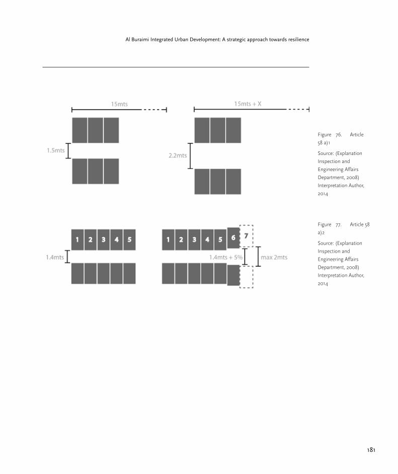
181
Al Buraimi Integrated Urban Development: A strategic approach towards resilience
Figure 76. Article
58 a)1
Source: (Explanation
Inspection and
Engineering Affairs
Department, 2008)
Interpretation Author,
2014
Figure 77. Article 58
a)2
Source: (Explanation
Inspection and
Engineering Affairs
Department, 2008)
Interpretation Author,
2014
182
Part 2.4 Housing and Urban Design
Recommendations
Urban planning instruments are developed
to guide and control physical and spatial
development. In the Omani context the
given land law as well as land allocation and
distribution practice together with the high
population growth rates have created a situation
where priority is given to supply the demand
of land, according to the law. Designation of
new residential areas to repond to the ever
increasing demand are reflected in the structure
plans, showing more and more a horizontally
expanding city. Qualitative physical planning
however, with guidelines on what kind of urban
qualities are going to be developed, which
density is considered to be appropriate, how
the open space should be integrated and other
qualitative aspects of physical planning were
not met by the structure plans. They focus on
the main road network to structure the city and
assign areas for expansion within a given time
frame.
The second planning instrument in use is the
so called krookie that translates the building
regulations to any single building to be errected.
The krookie only looks on one single plot and
on one single building and prescribes the
percentage of plot surface allowed to be built up,
the setbacks, the maximum number of storeys,
the maximum height of the building and the use
of the building.
A missing link between the city planning level
(structure and expansion) and the building
planning level (individual house) becomes
obvious and has been identified as crucial for
urban sprawl and low quality of life in Al Buraimi
and in other Omani cities as well.
Thus two strategic approaches are proposed
that would react on the current challenges:
First steps to foster quality of life in residential
areas: Open space recovery program in
consolidated areas and areas currently under
construction
○ Open or non-built-up urban space is to be
divided into‚ public open space, meaning that
access is free to everybody and ‚private open
space’ where access is restricted to a selected
number of people.
○ Public open space includes space
dedicated to transportation (roads, car parking
lots), sidewalks, green space and parks, setback
(distance space between road and plot, distance
between two neighbouring plots (sikkha).
○ Private open space is limited to the
non-built-up space within an individual plot,
including roof terraces or balconies that form
part of the build-up space itself.

183
Al Buraimi Integrated Urban Development: A strategic approach towards resilience
○ The open space recovery program would
follow a specific process, starting with an
inventory of public space, physical performance
and patterns of use.
Second steps to foster quality of life in residential
areas: Introducing the discipline of Urban
Design to mediate between the “structural
plan’” and the “krookie”.
Guidelines for urban design
○ Compactness and connectivity: Social and
spatial units of the city are neighbourhoods
instead of single buildings.
○ Neighbourhoods are organized and
designed in size and in shape (a cluster/
block of a limited, but not too small, number
of plots (about 40-50) and houses, that allow
internal open space for ventilation, shaded
sitting areas, shaded pedestrian walkways,
children's playgrounds, social gathering space
for neighbouring families and friends...)
○ Priority is given to building permits within
one designated neighbourhood, to foster a joint
building process within a limited time span and
to counteract sprawl.
○ A certain number of adjacent
neighbourhoods are interconnected by internal
roads, internal walkways (shown in figure
below). They may even share car parking areas.
○ A cluster of neighbourhoods share their
mosques, small shopping facilities, a health
care point, and other required daily services. Figure 78. Recom-
mendations.
On the left side, open
and un-built space is
highlighted. On the
right hand side, urban
design interventions are
proposed.
Source: (Author, 2014)

184
Part 2.4 Housing and Urban Design
○ Within the neighbourhoods traffic speed is
limited to 30 km/h. Roads are limited in width,
corresponding to the idea of mixed use street
space (e.g. car, pedestrians, and bikes).
○ Privacy within the neighbourhood is
given to the individual family residences
through respective designs and setbacks. A
neighbourhood may show different house types,
though the attached twin villa, or row-houses or
other compact building complexes should be
preferred in order to save land and to cope with
new regulations on proportional density. (FSR/
FAR)
Further studies are recommended on review
of planning standards and building codes,
and how to adapt them to the envisaged new
neighbourhood design. Best practice cases from
neighbouring countries with similar climatic,
cultural and historic background might be
included.
Moreover a competition on new housing types
for compact settlements could be launched.
This would include better building technologies
and the use of renewable energies.
A pilot project could test urban design on
the neighbourhood level using new housing
types. Through this, strengths and weaknesses
could be explored and documented within a
comprehensive monitoring process. It would
also help to formulate appropriate new building
guidelines.

185
Al Buraimi Integrated Urban Development: A strategic approach towards resilience
References
Akbar, J. (1989) ‘Khatta and the Territorial
Structure of the Early Muslim Towns’, in
Muqarnas: An Annual on Islamic Art and
Architecture. pp. 6, 22–32.
Batty, M. (2012) Building a science of cities.
Cities. 29S9– S16.
Burckhardt, T. et al. (2009) Art of Islam:
language and meaning. Bloomington, Ind.:
World Wisdom.
Burton, E. et al. (1996) The Compact City A
Sustainable Urban Form?. Routledge.
Cohen, M. (1983) The challenge of replicability.
World Bank Reprint Series. (287), . [online].
Available from: http://www-wds.worldbank.org/
external/default/WDSContentServer/WDSP/
IB/2002/11/11/000178830_98101903362316/
Rendered/PDF/multi0page.pdf (Accessed 16
January 2015).
Ebrahim, M. S. (2009) Can an Islamic model
of housing finance cooperative elevate the
economic status of the underprivileged? Journal
of Economic Behavior & Organization. [Online]
72 (3), 864–883.
Edwards, B. et al. (2006) Courtyard Housing:
Past, Present and Future. Taylor & Francis.
Al Gharibi, H. (2013) Urban Growth from
Patchwork to Sustainability Case Study: Muscat.
Technische Universität Berlin.
Gordon, P. & Richardson, H. W. (2007) Are
Compact Cities a Desirable Planning Goal?
Journal of the American Planning Association.
[Online] 63 (1), 95–106.
Ben-Hamouche, M. (n.d.) Corners-Sell
Regulations A Pioneer experience in The
Municipal Work and Sustainability. [online].
(Accessed 8 November 2014).
Ben-Hamouche, M. (2013) The paradox of
urban preservation: balancing permanence
and changeability in old Muslim cities. Journal
of Urbanism: International Research on
Placemaking and Urban Sustainability. [Online]
6 (2), 192–212.
Inspection and Engineering Affairs Department
(2008) Regulations for Organizing Building.
p.33.
National Center for Statistics and Information
(2014) Section 3 Housing.pdf.

186
Part 2.4 Housing and Urban Design
Krier, L. (1984) Urban Components. Vol. 54.
Architectural Design.
Abu-Lughod, J. L. (1987) The Islamic
city–Historic myth, Islamic essence, and
contemporary relevance. International Journal
of Middle East Studies. 19 (02), 155–176.
Mortada, H. (2003) Traditional Islamic
Principles of the Built Environment. Routledge
Cruzon.
Petersen, J. E. (2004) Oman: Three and a Half
Decades of Change and Development. Middle
East policy. 11 (2), 125–137.
Punter, J. & Carmona, M. (1997) The Design
Dimension of Planning: Theory, Content, and
Best Practice for Design Policies. Taylor &
Francis.
Ragette, F. (2003) Traditional domestic
architecture of the Arab Region. [Stuttgart]:
Edition Axel Menges.
Salat, S. & Bourdic, L. (2011) Urban Complexity,
Efficiency and Resilience. Urban Morphology.
[online]. Available from: http://cdn.intechopen.
com/pdfs/31591/InTech-Urban_complexity_
efficiency_and_resilience.pdf (Accessed 16
January 2015).
Salingaros, N. A. (2007) Mathematical Theory
of the Urban Web. Journal of Urban Design.
[Online] 3 (1), 53–71.
Soloman, S. (2013) Good Governance
and Sustainability in Residential Land
Administration in Muscat Oman.
Scholz, F., 1978. Sultanate of Oman: A
geographical introduction of Oman, its natural
resources, its people, its settlements, its
economy, and its modern development. Part I
ed. Stuttgart: Ernst Klett Printing.
Unwin, R. (1909) Town planning in practice:
an introduction to the art of designing cities
and suburbs. reprint. London: Princeton
Architectural Press, 1994.

187
Al Buraimi Integrated Urban Development: A strategic approach towards resilience

Part 2.5 Heritage management and responsible tourismAna Alcántara

Rapid economic development and social
changes in Oman have led to a neglection of
heritage. In an effort to carry out the overall
“Vision 2020” focusing on diversifying the
economy, it has been identified that the tourism
sector is crucial to develop. Tourism in Oman
is supposed to be diverse responding to the
huge variety of natural and socio-cultural
backgrounds of the many tribes. Despite being
neglected this far, the remaining heritage in
Al Buraimi might be able to contribute to
locally responsible tourism development that
can improve the lifestyle of the community,
increase the income of the families, preserve
the natural and cultural heritage, and reinforce
local attachment to the heritage area. This study
proposes a set of criteria and management plan
for the implementation of responsible tourism.

190
Part 2.5 Heritage Management and Responsible Tourism
Assesment of the current
state of heritage
“Over the last fifty years tourism has become
one of the largest economic sectors globally,
accounting for some 9% of the world’s GDP
and over 200 million jobs” (United Nations
World Tourism Organization, 2013, p.14). Also
in Oman tourism is considered one of the most
progressive economic activities that can benefit
other economic activities due to its wide scope.
Different assets give value to the tourist sector
such as culture, heritage and art and enable it to
become a key sector to the economic growth of
a country and reduce poverty levels.
In June 2004, the Omani Ministry of Tourism
(MOT) was created (i) to increase the
contribution to the GDP by the tourism sector,
(ii) to increase the level of employment of
Omani nationals in the sector, (iii) to increase
the average annual growth rate for the income
from tourism, and (iv) to be responsible for the
promotion and marketing of Oman as a tourist
destination(Ministry of Tourism, Sultanate of
Oman, 2005).
The MOT has the duty to preserve cultural
integrity and preserve Omani identity; to
promote the historic, cultural and natural
heritage and ethos of traditional hospitality.
Different goals are set for the tourism sector
such as (i) achieving an annual average
growth rate of at least seven percent, (ii)
improvement of employment opportunities
for Omani nationals, and (iii) to continue with
balanced regional development. The MOT’s
strategy also outlines how Oman will achieve
maximum benefits for local communities,
activate domestic tourism, encourage the role of
the private sector in tourism development, and
commit to sustainable tourism development”
(‘Oman: Focusing on diversification’, 2010).
Travel and Tourism in Oman generated 37,000
jobs directly in 2013 (3.3 percent of total
employment) and this is forecast to grow by
11.4 percent in 2014 to 41,000 (3.6 percent of
total employment). This includes employment
by hotels, travel agents, airlines and other
passenger transportation services (excluding
commuter services). It also includes the
activities of the restaurant and leisure industries
directly supported by tourists (World Travel and
Tourism Council, 2013).
In order to promote the importance and benefits
of the tourist sector many educational programs
have been established, such as the annual
schools’ education program with presentations
to around 40 schools and colleges.
Previous page:
The ruins of Hamasa
Source: (Salcedo, 2014)
191
Al Buraimi Integrated Urban Development: A strategic approach towards resilience
Tourism in Al Buraimi
The development of Al Buraimi in the tourism
sector has been different than that in the national
context. Part of the national budget goes to
tourism in the Governorate of Al Buraimi, but it
has to be distributed to Al Buraimi, Mahdah and
Al Sunaynah.
The workforce in the hotel sector in Al Buraimi
Municipality totaled 168 in 2011 and decreased
to 137 by 2012. The increase in the number of
expats living in the area can be reflected in the
Omani Ratio of workforce in the tourism sector
which was 25.5 percent in 2012 down from 36.9
percent in 2011 (National Center for Statistics
and Information Sultanate of Oman, 2013).
Even though efforts have been made to improve
the “Omanisation” in the tourism sector, the
amount of foreigners working in this sector is
still higher.
Minor projects run by locals and young people
are required. The Chamber of Commerce and
Industry in Al Buraimi wants to encourage young
citizens to become entrepreneurs and to enter
into the private sector, by providing them training
and financing for facilities. “The Ministry of
Tourism...[is] making efforts to support tourism
development, encourage entrepreneurship and
provide the Omani youth with opportunities to
establish their own projects. [sic] The projects
announced to be built at Al Buraimi include a
166,991 square meters hotel and shopping and
entertainment center, an environmental tourism
camp spread over 107,077 square meters, and a
four-star hotel and villas project stretching over
50,000 square meters at Hay Al Nafahat. […] The
Oman Development Bank (ODB) is expected to
Box 19. Responsible and
sustainable tourism
According to the UNWTO
sustainable tourism should “(i) use
environmental sources in an optimal
way, keeping a balance with the
natural ecological processes without
threatening nature due to tourism
development, minimizing adverse
impacts on the environment and
preserving heritage and biodiversity,
(ii) maintain the cultural identity of
the host communities, preserving
their heritage and traditional values
and encourage tolerance and
understanding between the host and
visitor, and (iii) to provide long term
economic benefits to all stakeholders
involved in the tourism sector and to
the destination, and to contribute to
poverty reduction” (United Nations
World Tourism Organization, 2005).

192
Part 2.5 Heritage Management and Responsible Tourism
play a big role in turning these opportunities
into reality by providing the required funding to
the Omani entrepreneurs (Times News Service,
2014).
Heritage as an asset for responsible
tourism
Oman is a country with a long tradition in
human settlements, handmade art crafts and
the use of oral traditions and expressions to
pass on knowledge, cultural and social values
and collective memory.
According to UNESCO, heritage is defined as
“our legacy from the past, what we live with
today, and what we pass on to future generations.
Our cultural and natural heritage are both
irreplaceable sources of life and inspiration”
(UNESCO World Heritage Center, 2008, p.5).
Cultural heritage refers to monuments, groups
of buildings and sites with historical, aesthetic,
archaeological, scientific, ethnological or
anthropological value and natural heritage
refers to outstanding physical, biological and
geological formations, habitats of threatened
species of animals and plants and areas with
scientific, conservation or aesthetic value.
The preservation of tangible heritage assets
ensures that the memories of the community of
the past and the qualities that provide identity
to places and enable future generations to
have a glance of how the past used to look
like and to create a sense of continuity that is
an essential part of cultural identity. Tangible
heritage assets have an advantage over their
intangible counterparts, as the preservation
and conservation of the tangible assets can
be reached by taking proper care to preserve
their authenticity, while for intangible assets to
be preserved they have to be transferred from
generation to generation.
In order for intangible cultural heritage to be
preserved and conserved, legal measurements
have to be taken in order to maintain their
cultural property, folklore and traditions relative
to the culture.
Negative effects of tourism and
solutions to them
Even though tourism is considered a means to
improve the living conditions of communities,
negative features can be also emphasized such
as (i) the increase of local pollution in the air,
water and land that can be produced by the
tourism facilities, (ii) the use of non-renewable
resources in a mindless way by hotels and
resorts, (iii) the damage of the flora and fauna
around a site, (iv) the degradation to the heritage
site, and (v) the poor working conditions some
of the workers in travel and tourism can face.

193
Al Buraimi Integrated Urban Development: A strategic approach towards resilience
Thus worldwide and in Oman much attention
is given to more sustainable or responsible
forms of tourism, that take “full account of
its current and future economic, social and
environmental impacts, addressing the needs of
visitors, the industry, the environment and host
communities” (United Nations World Tourism
Organization, 2005).
Sustainable or responsible tourism is tourism
“which minimizes negative social, economic
and environmental impacts, generates greater
economic benefits for local people and
enhances the well-being of host communities,
improves working conditions and access to the
industry, involves local people in decisions that
affect their lives and life chances, makes positive
contributions to the conservation of natural and
cultural heritage embracing diversity, provides
more enjoyable experiences for tourists through
more meaningful connections with local people,
and a greater understanding of local cultural,
social and environmental issues, provides
access for physically challenged people, is
culturally sensitive, encourages respect between
tourists and hosts, and builds local pride and
confidence.” (Responsible Tourism Partnership,
2002). The interaction between host and visitor
is promoted to enable a broader understanding
of the local cultural and social patterns.
Box 20. UNESCO World Heritage
The formal effort to safeguard intangible cultural heritage through UNESCO
began in 1972 with the Convention for the Protection of World Cultural and
Natural Heritage and the creation of the World Heritage List (Kurin, 2004).
The World Heritage list gives international recognition and national support for
the restoration, conservation, preservation of tangible monuments, sites and
landscapes.
According to UNESCO, “tangible heritage” includes buildings and historic
places, monuments, artifacts, etc., which are considered worthy of preservation
for the future. These include objects significant to the archaeology, architecture,
science or technology of a specific culture”(‘Tangible Cultural Heritage | United
Nations Educational, Scientific and Cultural Organization’, n.d.) and “intangible
cultural heritage” was described in the form of a list, as oral traditions and
expressions […] and traditional craftsmanship, as well as the sites and spaces
in which culturally significant activities and events occur” (Kurin, 2004, p.67).

194
Part 2.5 Heritage Management and Responsible Tourism
Box 21. People perceptions about Al Buraimi’s attractiveness
To understand how the community perceives Al Buraimi, an open question was
posed on the community questionnaires to determine the reasons why people
should go to Al Buraimi. The outcomes were very different, while some of the
survey respondents consider Al Buraimi a place with great commercial activity
and considered it to be a tourist attraction; most of the community prefers to go
to Al Ain for shopping. The ladies tailor shops are very famous in the area with
clients from all around Oman. Also, the repair of cars has become a growing
industry in Al Buraimi.
Even though the community considered the Forts as part of the attractions of Al
Buraimi, only 44 percent of the survey respondents have visited the Al Khandaq
Fort and 37 percent the Al Hillah Fort.
While the living conditions are stated as part of the reasons for visiting Al Buraimi,
since the establishment of the physical border between Al Ain and Al Buraimi in
2009, the free transit between the two cities has become more difficult, and the
advantage of Al Buraimi being cheaper than Al Ain is no longer considered as a
priority because of the long commute.

195
Al Buraimi Integrated Urban Development: A strategic approach towards resilience
Heritage assets inventory for tourism in Al Buraimi
Figure 79. Location of
heritage sites
Source: (Author, 2014)
This study identifies the
following inventory of
tangible heritage sites
and intangible heritage
features was identified
during the fieldwork in
autumn 2014.
Box 22. Tangible assets criteria
1. Cultural traditions, the assets have to be part of the cultural traditions and belong to
Al Buraimi´s identity.
2. Ancient traditional human settlement should represent human interaction and the
land-use of Al Buraimi.
3. Example of a type of building or architectural typology specific to Al Buraimi; .
4. Significant natural habitats for conservation of biological diversity, including those
containing threatened species.
5. Economic value for the future benefit of the community, if the asset is developed as a
tourist attraction and new job opportunities appear.
The following map shows the location of the
tangible and intangible assets described ahead.

196
Part 2.5 Heritage Management and Responsible Tourism
Ancient residential village Sa´ara
Located close to the border with the United Arab
Emirates, and part of the Buraimi Oasis, Sa´ara
was occupied by around four to five thousand
people and used to be a very important site for
farming and leisure in the summer; since it was
located in the Buraimi Oasis, the abundance of
palm trees for farming with the use of the aflaj
system around the area provided a very shaded
and comfortable place.
Today, the site is mostly abandoned, due to a
shift in economic activities. Few plots are still
being used for farming.
Ancient residential and market village
Hamasa
It used to be an important market in the area
ruled by the Al Shamsi family. People from
As Sunaynah, Sohar, Dubai and Ibri came to
Hamasa to buy goods, trade animal, fruits,
vegetables, and slaves. There are no existing
written records of the way Hamasa used to look
or how the inhabitants used to live, nor about
the number of inhabitants or market shops. The
use of tents as households was very common;
families used to live all together.
Few structures remain today. It is known that the
market and the houses were separated by the
wadi that crossed through Hamasa.
Figure 80. Decay
situation in Sa´ara.
Sa´ara is mostly
abandoned and is
occupied by eastern
Asian people who pay
a small amount to the
land owners of the plots
in order to use them as
shelter and as small farms
Source: (Author 2014)
Figure 81. Decay
situation in Hamasa
Source: (Author 2014)
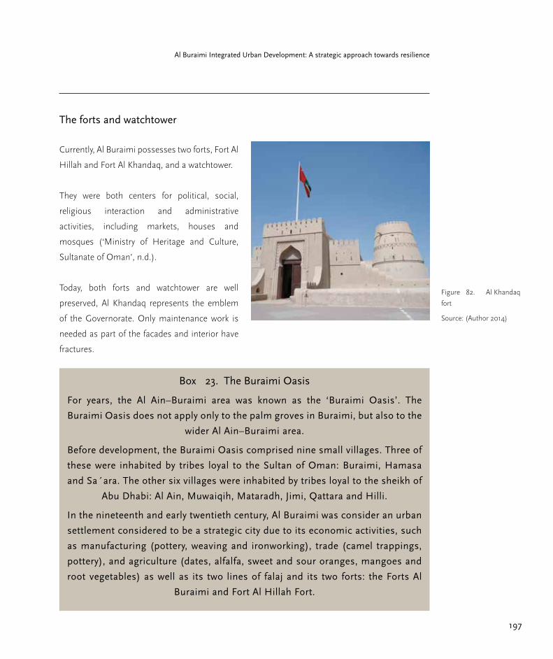
197
Al Buraimi Integrated Urban Development: A strategic approach towards resilience
Figure 82. Al Khandaq
fort
Source: (Author 2014)
The forts and watchtower
Currently, Al Buraimi possesses two forts, Fort Al
Hillah and Fort Al Khandaq, and a watchtower.
They were both centers for political, social,
religious interaction and administrative
activities, including markets, houses and
mosques (‘Ministry of Heritage and Culture,
Sultanate of Oman’, n.d.).
Today, both forts and watchtower are well
preserved, Al Khandaq represents the emblem
of the Governorate. Only maintenance work is
needed as part of the facades and interior have
fractures.
Box 23. The Buraimi Oasis
For years, the Al Ain–Buraimi area was known as the ‘Buraimi Oasis’. The
Buraimi Oasis does not apply only to the palm groves in Buraimi, but also to the
wider Al Ain–Buraimi area.
Before development, the Buraimi Oasis comprised nine small villages. Three of
these were inhabited by tribes loyal to the Sultan of Oman: Buraimi, Hamasa
and Sa´ara. The other six villages were inhabited by tribes loyal to the sheikh of
Abu Dhabi: Al Ain, Muwaiqih, Mataradh, Jimi, Qattara and Hilli.
In the nineteenth and early twentieth century, Al Buraimi was consider an urban
settlement considered to be a strategic city due to its economic activities, such
as manufacturing (pottery, weaving and ironworking), trade (camel trappings,
pottery), and agriculture (dates, alfalfa, sweet and sour oranges, mangoes and
root vegetables) as well as its two lines of falaj and its two forts: the Forts Al
Buraimi and Fort Al Hillah Fort.

198
Part 2.5 Heritage Management and Responsible Tourism
Intangible assets
Building techniques and materials
Due to the modernization in the 1970s, the
ancient building techniques and building
materials have lost their traditional importance.
New houses with modern building materials
and amenities have appeared, such as air-
conditioning. The cities were left abandoned
and traditional settlements are nowadays in
a very precarious condition. The restoration
of the mud-brick houses is crucial, since they
are a trace of history that could potentially be
transferred to a younger generation.
The main building materials previously
employed in Oman are mud brick, baked brick,
stone, mangrove poles, palm trees and lime,
Box 24. Intangible assets: criteria
○ In order to identify the intangible heritage assets, a set of criteria were established. These
assets have to be related to the following categories:
○ Cultural traditions; the assets have to be part of the cultural traditions.
○ Ownership of cultural property; should belong to the Al Buraimi´s identity.
○ Example of a type of building or craft technique; example of a unique building technique
as well as part of the ancient craft and arts in Al Buraimi.
○ Risk of disappearing; due to modernization, part of the knowledge is in risk of being lost.
○ Economic value for the future benefit of the community; if the asset is developed as part
of a tourist attraction and new job opportunities appear.
used for mortar and plaster. This traditional
earth architecture of has climatic properties that
ensure constant temperature within the building
during the whole year without the existence of
windows.
The traditional summer houses were usually
larger with higher ceilings where small windows
can be seen for the entrance of light; winter
houses were more compact, having lower
ceilings to preserve the warmth inside. “In
the mud-brick houses, the ground floor was
commonly used for storing and the upper floors
for living. Walls were up to 80 centimeters thick
on the ground level (Gaube, Heinz and Gangler,
Anette, 2012, p.80).

199
Al Buraimi Integrated Urban Development: A strategic approach towards resilience
Traditional craft and arts
Various traditional crafts are inspired by the
local environment and the local resources.
For instance, Pottery making in the interior of
Oman was a highly commercial practice, the
production got into high volume with the use
of the pottery wheel and the creation of small
factories (Richardson, Neil and Dorr, Marcia,
2003).
As in other areas of the country where dates
are found, basketry is a widely practiced craft.
Different types of plaited–strip baskets are
needed at different times of the year, for date-
collection or storage, or for special occasions
like Eid; the request for the large rectangular-
storage basket which also serves as a cooking
bag for shuwa´, the traditional Omani dish of
roasted goat meat (Richardson, Neil and Dorr,
Marcia, 2003).
The conservation of the intangible heritage
assets provides traditions, practices, and forms
of knowledge that help cultural identity survive to
subsequent generations. Due to modernization,
building techniques and everyday appliances
local traditions are devaluated or endangered or
both.
Figure 83. Pottery in
Nizwa
Source: (Author 2014)
Figure 84. Basketry in
Al Buraimi
Source: (Author 2014)

200
Part 2.5 Heritage Management and Responsible Tourism
Figure 87. Dry falaj in
Sa´ara.
Due to over exploitation
and lack of research
from side of the Omani
authorities on the field, the
falaj stopped supplying
water.
Source: (Salcedo 2014)
Box 25. Further tangible assets examples: Falaj irrigation system
In 2006, the Falaj Daris Falaj Al Khatmeen in Willayat Nizwa, the Falaj Al Malaki in Willayat Izki,
the Falaj al Mayssar in Willayat Al Rustaq and the Falaj Al Jeena in Willayat Sur were inscribed in
the World Heritage List due to their ancient engineering technologies, sustainable use of water
resources for the irrigation of palms and crops, the strengthening of the community values and
the mutual community collaboration.
The conservation of the tangible heritage assets provides the future generation with a
concrete notion of the past. They have the greater potential to provide economic benefit to
the community, providing new job opportunities as a tourism attraction. Proper management,
including information centers and staff, is required in order to increase the tourism value as well
as to preserve the economic, social and environmental responsibility stated previously in this
study.

201
Al Buraimi Integrated Urban Development: A strategic approach towards resilience
Hamasa: an example
for responsible tourism
development
The area of Hamasa can exemplify how to
preserve cultural heritage, and how to put
heritage into value for a responsible tourism
concept that would improve the entire
community, increase the income of the families,
and reinforce the local attachment.
Hamasa is overlooked by the Hamasa
Watchtower and divided by the wadi into the
residential area and the market area. The
remains of two falaj entering into the area can
be tracked with the remaining inspections wells,
one leading north to south across the wadi
towards the Hillah Fort and the other directly in
the middle of the Hamasa area.
The remaining buildings are precious in value
due to the building techniques used to construct
them. The actual physical situation of the mud-
brick houses however is very critical, shifting
sands has covered most of the remaining
buildings.
According to the Ministry of Housing, the land
use of Hamasa still remains as agricultural;
reason why some farms are still in use.
Nowadays, other types of economic activities are
taking place in Hamasa, such as coffee shops,
restaurants and small grocery shops, mostly run
by expatriates though owned by Omanis.
New markets have absorbed the role of the
Hamasa market, such as the souqs close to the
Al Hillah Fort. These are not only considered as
trade centers but as important meeting points
for the local community. The new souq is a small
white building with a watchtower in the center.
While inside the market mostly male expatriate
vendors sell imported products mainly from
China; including earth and clay artifacts, spices,
shoes, food and traditional walking sticks that
can be found outside the stalls. Female vendors
sell plaited-strip baskets, traditional goods and
some pottery. Fresh fish from Sohar and other
ports of Oman can also be bought daily.
Spatial configuration
Hamasa used to be a very compact village,
mainly accessed by donkeys/camels to enable
the transport of goods into and out of the
market. The construction of asphalt roads inside
Hamasa was stopped in order to preserve the
traditional identity of the place.

202
Part 2.5 Heritage Management and Responsible Tourism
Vernacular architecture
The remaining mud-brick houses in Hamasa
can be categorized by location, type of
building, (residential, mosques, shops) and by
construction materials such as stones, baked
bricks, and mud bricks.
Most of the mud-brick houses used to have
pitched palm-frond (barristi) roofs and the
bigger houses had flat earth roofs supported
by palm trunks or mangrove poles. They had
rooms with high ceilings for the hot weather
season and low ceilings for the cold weather.
Few windows can be found on ground level due
to the importance of privacy; whereas many
can be found above. Some renovations can be
observed and appreciated where earth roofs
have been changed to wooden roofs.
The foundations are shallow or have been built
directly on the ground. Only the houses as
well as the shops close to the wadi, had higher
foundations made of irregular stones. This was
to protect them from the high water levels during
the rainy season. The falaj system infrastructure
is still noticeable in some households, although
in a bad condition.
Tenure
Since plots in Hamasa have been inherited, the
delimitation of some plots can be distinguished
by stone fences or concrete walls recently built
in order to delimitate property. Even though
abandoned, plots in Hamasa are extremely
valuated because of the long history of
inheritance they posses.
Identity at stake
In general, the new lifestyle in Hamasa and in
Al Buraimi has led to the threat of the loss of
the intangible assets mentioned above. The
oral transmission of knowledge was considered
a tradition, covering literature, graphic arts
and performed arts. Moreover, the knowledge
related to building techniques using mud-brick
is liable to get lost if it is no longer preserved
and transmitted. Hamasa is an extraordinary
example of how vernacular architecture used
to look like, thus if it is not safeguarded it is
possible that this part of the Al Buraimi identity
will become extinct.

203
Al Buraimi Integrated Urban Development: A strategic approach towards resilience
Guidelines and Action plan
towards responsible tourism
in Hamasa
The purpose of this section is to provide a set
of strategies towards responsible tourism based
on the heritage assets in Hamasa, addressing
the issues of management, revitalization
centered on re-habitation, conservation, training
and skill development.
In order to become a tourist attarction based
on these assets, the guidelines include ancient
settlements for housing purpose, the agriculture
and animal breeding as economic activity and
the reuse of ancient handicraft techniques.
It is important to tackle the characteristics of
responsible tourism, and to cover the aims of
the Omani “Vision 2020” by increasing the
importance of the tourism sector, fostering the
preservation of social, cultural and environmental
resources of the country, including more
Omanis in the tourism sector and improving
the lifestyle of the host community.
For the sake of elaborating guidelines and
recommendations for responsible tourism, a set
of criteria have been taken into consideration:
a. The identification of opportunities and
weaknesses
b. The recognition of the stakeholders
involved and the development of
linkages between them
c. The design of specific projects,
including a trial area
d. The impact on the local community
e. The creation of new job opportunities
f. The improvement of capacity building
g. The raising of awareness
One of the main purposes is to promote active
collaboration between the state, the private
sector and civil society. It is for the sake of the
diversification of the tourist sector, to develop
high qualified and well-trained human resources.
The following action plan is developed in three
different phases. The responsibilities and
interactions between the diverse stakeholders
vary.
204
Part 2.5 Heritage Management and Responsible Tourism
Phase I (short term)
Physical planning
For Phase I, it is required to select a trail
area, where the remaining buildings will be
categorized in three degrees of preservation, the
ones that are in an adequate state, those that
can be preserved, and those where only small
intervention are needed, such as refurbishments.
The ones that are in an adequate state, that
needs to be restored, and the ones that are in
ruins. The classification of the buildings has to
be coordinated with the Ministry of Heritage
and Culture in order to have accurate criteria of
classification.
The trial area, Hamasa I, should be restored,
preserving the heritage resources and
minimizing further destruction.
Actions and activities
The creation of man-made attractions is required
such as a small-scale museum, for the display
of local artwork as well as local handicrafts.
Small restaurants and coffee shops should be
run inside the trial area. These places should
provide local food and be run by the community.
New gift shops should be established where
local handicrafts can be sold and workshops can
take place.
Parallel to these actions, awareness programs
have to be implemented to encourage local
communities to participate; capacity building
is also required to improve the hospitality, and
tourism management skills to provide quality
services. Additionally, training for the community
is required for the development, management
and operation of small businesses.

205
Al Buraimi Integrated Urban Development: A strategic approach towards resilience
Stakeholders involved
In this phase, an active collaboration between
most of the stakeholders is required from the
beginning of the action plan and for its overall
success. Even though building interventions
are needed in Hamasa; the Ministry of Heritage
and Culture is the main entity responsible for
the protection and preservation of the ancient
building; the ministry has to provide guidelines
on how intervention should proceed. The
involvement of the civil society is essential
to run the new local activities. The Chamber
of Commerce and Industry has the ability to
provide trainees with capacity building in the
tourist sector and for the creation of small
businesses. The media, academia and the
Ministry of Tourism are the bodies responsible
for awareness programs and campaigns to
promote participation in tourism. The media
in collaboration with the Ministry of Tourism is
also responsible for the marketing of the newly
developed pilot project.
Outputs/Goal
A certain number of jobs will be created with
the new economic activities The promotion
of tourism will increase the community
involvement in the sector, giving them the tools
to have a say in the development of their own
home area.
Figure 88. Interven-
tions in Phase I
Source: (Author 2014)

206
Part 2.5 Heritage Management and Responsible Tourism
Phase II (medium term)
Physical planning
Phase II will follow the same guidelines as
in Phase I, Hamasa II will be created. The
restoration of the decayed buildings, the
preservation of the heritage resources as well as
the minimization of further destruction remain
as the main priorities.
Actions and activities
In phase II, linkages are developed to local
agriculture and local products as part of the
activities. The falaj system should be also
included in order to revive the Oasis’ life, and
provide an example of how life used to be. The
breeding of animals should also be integrated
as part of the activities.
To develop a structured holistic tourism
experience based on the available heritage
resources, walking night tours can be
established to visit the Old souq – the Al
Hillah Fort – the New souq – the Al Khandaq
Fort – and the Hamasa Tower – Hamasa. In
every spot, informational brochures as well as
trained representatives should be available.
This includes the establishment of a tourist
information centre.
Stakeholders involved
In this phase, the labor of the local community,
mainly the ones with agricultural knowledge, is
required. The main responsibility of the Ministry
of Heritage and Culture remains the protection
and preservation of the ancient buildings. The
creation, promotion and enhancing of cultural
events, such as festivals in Hamasa have to be
run and supervised by the Ministry of Tourism,
with the aim to involve the community in
cultural events as well as to attract more tourists
to Al Buraimi.
The cooperation between the Ministry of Tourism
and the private sector in this phase is important
for the promotion of tourism though the private
enterprises and for the development of tourism
products, such as maps and brochures.
Outputs/Goal
New jobs will be created with the new economic
activities and with the integration of agriculture.
With new tourist activities created, trained people
will be required for the delivery of information
along the different spots of the walking tour,
as well for running the tourist information
center. Providing economic incentives in
tourism, agriculture and the production of local
merchandise, will add value to Hamasa and to
Al Buraimi.

207
Al Buraimi Integrated Urban Development: A strategic approach towards resilience
Figure 89. Interven-
tions in Phase II
including interventions in
Phase I
Source: (Author 2014)
Figure 90. Night tour
walking route
The Walking night tours
are intended to provide
and holistic tourism
experience based on
the available heritage
resources. Trained people
will be required for the
delivery of information
along the different spots
of the walking tour.
Source: (Author 2014)

208
Part 2.5 Heritage Management and Responsible Tourism
Phase III (long term)
Physical planning
Phase III will follow the same guidelines as in
Phase I, Hamasa III will be created. Small-scale
accommodation facilities can be established,
such as “Bed and Breakfasts” and small scale
hotels. Large-scale renovation will be required to
enable the provision of high quality service.
Actions and activities
With the trial project running in different areas
in Hamasa, the provision of accommodation
can be made in order to extend the visit of the
tourist to more than a day.
Stakeholders involved
The private sector is the main actor in this phase,
for running accommodations that fulfill the need
of the tourist and reach high quality standards.
The engagement of the entire community in
of high importance for the success of phase
III since the aim is to provide an example of
responsible tourism in an Oasis settlement.
Outputs/Goal
The number of new jobs will increase in the
different areas of the accommodation facilities.
The objective is to improve quality standards
in the tourism sector and to extend the stay of
visitors by providing an example of traditional
way of life.
Further actions: festivals
According to the outcomes from the survey
conducted in Al Buraimi, different actions have
to be taken in consideration of attracting more
tourists to the area. 56% percent of the survey
respondents have not visited the Al Khandaq
Fort and 63 % have also not visited the Al
Hillah Fort. In order to foster more visits, the
Ministry of Tourism in collaboration with the
local authorities, could promote the creation of
festivals in the area taking place in both forts.
As part of the areas to improvement, the lack
of information provided on the heritage assets
in Al Buraimi make it difficult for visits by non-
Arabic speakers to partake, since information is
only transmitted orally.

209
Al Buraimi Integrated Urban Development: A strategic approach towards resilience
Figure 91. Interven-
tions in Phase III,
including interventions in
Phase I and Phase II
Source: (Author 2014)
Figure 92. Summary
of the action plan
Source: (Author 2014)
Action plan
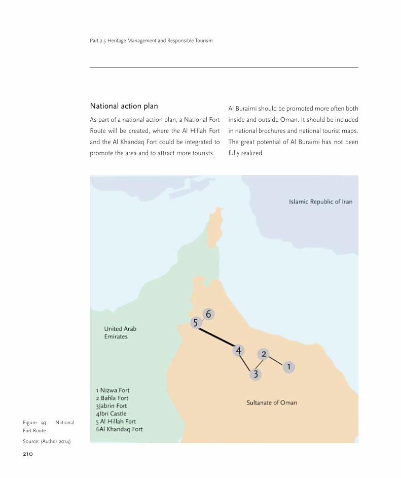
210
Part 2.5 Heritage Management and Responsible Tourism
National action plan
As part of a national action plan, a National Fort
Route will be created, where the Al Hillah Fort
and the Al Khandaq Fort could be integrated to
promote the area and to attract more tourists.
Al Buraimi should be promoted more often both
inside and outside Oman. It should be included
in national brochures and national tourist maps.
The great potential of Al Buraimi has not been
fully realized.
Figure 93. National
Fort Route
Source: (Author 2014)

211
Al Buraimi Integrated Urban Development: A strategic approach towards resilience
Conclusions
Modernization has played an enormous role in
the transformation of lifestyle and economical
behavior in Al Buraimi. The “Vision 2020” has
been taken on as criteria for the diversification
of the economy, and tourism has been selected
as the main sector for development.
How might this apply to some heritage assets,
such as those in Al Buraimi, which have
remained in a long state of abandon and decay?
How can proper heritage management recover
and preserve the tangible/intangible assets to
become part responsible tourism development
for the sake of the improvement of the lifestyle of
the community, in order to increase the income
for the families, to preserve of the natural and
cultural heritage assets and the reinforcement of
the local attachment to the heritage area?
This study shows that Al Buraimi has substantial
tangible and intangible heritage assets thereby
making it an ideal segment of a responsible
tourism development plan. The benefits gained
will involve not only the civil society, but the
private sector and the local government. Most
notably the improvements required for the
development of the traditional settlement of
Hamasa must go beyond it and involve the
oasis as a whole and Al Buraimi as an exemplary
part of it. It is crucial to reinforce the sense
of ownership and cultural identity in the new
generations.
Figure 94. Ruins in
Hamasa
Source: (Salcedo, 2014)

212
Part 2.5 Heritage Management and Responsible Tourism
References
Anon (n.d.) Chronicle of the Middle East &
North Africa. Available from: http://fanack.
com/en/countries/oman/history/
Anon (n.d.) Ministry of Heritage and Culture,
Sultanate of Oman. Available from: http://www.
mhc.gov.om/tabid/358/Default.aspx
Anon (n.d.) Tangible Cultural Heritage | United
Nations Educational, Scientific and Cultural
Organization. Available from: http://www.
unesco.org.
Bertelsmann Stiftung, BTI 2014 (2014) Oman
Country Report. Available from: http://www.
bti-project.org.
Debouchet, Sophie (2012) Oman Migration
Profile. Available from: http://cmrsdb.
aucegypt.edu/index.php/eng/content/
download/1900/11324/file/10.%20Oman_2012.
pdf.
Ennis, Crystal A. & Al-Jamali, Ra’id Z. (2014)
Development Planning and Labour Market
Trends in Oman. Available from: http://www.
chathamhouse.org
Gaube, Heinz & Gangler, Anette (eds.) (2012)
Transformation Processes in Oasis Settlements
of Oman. Muscat, Oman: Al Royal Press and
Pulishing Hoswe.
Gössling, S. (1999) Ecotourism: a means
to safeguard biodiversity and ecosystem
functions? Ecological Economics. 29 (2),
303–320.
Kurin, R. (2004) Safeguarding Intangible
Cultural Heritage in the 2003 UNESCO
Convention: a critical appraisal. Museum
International. [Online] 56 (1-2), 66–77.
Ministry of Tourism, Sultanate of Oman (2005)
Tourism Strategy in Oman. Available from:
http://www.omantourism.gov.om
National Center for Statistics and Information
Sultanate of Oman (2013) Statistics Tourism.
Available from: http://www.ncsi.gov.om
Responsible Tourism Partnership (2002) Cape
Town Declaration. Available from: http://www.
responsibletourismpartnership.org/CapeTown.
html.
Richardson, Neil & Dorr, Marcia (2003) The
Craft Heritage of Oman. Vol. 1, 2 vols. Dubai,
UAE: Motivate Publishing for the Omani Craft
Heritage Documentation Project.

213
Al Buraimi Integrated Urban Development: A strategic approach towards resilience
Smith, David & Talwar, Rohit (2007) The Future
of Travel & Tourism in the Middle East - A
Vision to 2020. Available from: http://www.
thegff.com/Publisher/File.aspx?id=14985.
Times News Service (2014) Oman tourism
ministry declares details of 22 locations,
projects development plans. Times of Oman.
Available from: http://www.timesofoman.com
UNESCO World Heritage Center (2008) World
Heritage Information Kit. Available from: http://
whc.unesco.org.
United Nations World Tourism Organization
(2005) Definition | Sustainable Development
of Tourism [online]. Available from: http://sdt.
unwto.org.
United Nations World Tourism Organization
(2013) Sustainable Tourism for Development
Guidebook. Available from: http://www.ilo.org.
World Travel and Tourism Council (2013) Travel
and Tourism Economic Impact 2014 Oman.
Available from: http://www.wttc.org
WWF International (2001) Guidelines for
community-based ecotourism development.
Available from: http://www.widecast.org

Part 3 Further recommendationsSonja Nebel
contributors: Panagiotis AchamnosAna AlcántaraPedro BecerraFlorencia CarvajalJesús Salcedo

The key fields of strategic interventions as
presented in the preceding chapters demand
besides the “what to do” also for the “how to
do”. Urban governance reffers to “the sum of the
many ways individuals and institutions, public
and private, plan and manage the common
affairs of the city. It is a continuing process
through which conflicting or diverse interests
may be accommodated and cooperative action
can be taken. It includes formal institutions as
well as informal arrangements and the social
capital of citizens”.
We follow hereby this definition of urban
governance given by UN-Habitat and would
like to focus on a few key aspects that have
been turned out as cross-sector or cross-cutting
issues to be mentioned as crucial for a successful
process towards a resilient urban development
in Al Buraimi. The following chapter presents the
issues and also recommends a set of tools that
can be implemented. Next, the topic of capacity
development is explained and recommendations
are made as well. Finally, a recommended list of
further studies is presented.

216
Part 3. Further Recommendations
Cross cutting issues
Cross-cutting issue: Decentralization
It has been proved that the strong top-down
decision-making process is (i) a time-consuming
one and (ii) often not responding properly to the
local needs and potentials. The legal framework
i.e. physical planning standards, building codes
or road design manuals, is supposed to allow
equal living conditions nation wide but do not
consider diverse natural-geographic settings
within the country, diverse micro-cultural
background and diverse economic conditions.
Any sustainable future development concept
however would rely rather on local needs
and potentials than on general regulations.
Interviews with experts from different local
governmental institutions in Al Buraimi have
proved the importance of locally based human
resource and revealed the high expertise and
knowledge of the governmental staff.
Locally based decision-making power might
be able to react faster on dynamics of change,
might understand better and exploit the local
potentials for development. It may also be
better prepared for planning and managing
the common affairs of the city. Establishing
the Municipal Council in Al Buraimi seems to
be a good precondition for a locally based and
promising urban governance for sustainability.
Cross-cutting issue: Inter-sectoral
cooperation and coordination
All sector-related assessments have mentioned
the difficulties arising from uncoordinated
planning and implementation and from
missing interdepartmental coordination and
cooperation. When it comes to strategic planning
for a sustainable development, coordination and
cooperation however becomes crucial. As all
relevant Ministries are represented with their Al
Buraimi branches, we recommend to establish
an interdisciplinary and interdepartmental
council, kind of “task-force resilient Buraimi”.
This council representing all governmental
bodies involved will discuss and decide about
priorities of action and implementation and will
accompany the strategic procedure. The council
should also decide about further responsibilities.
Cross-cutting issue: Participation
The many interviews that could have been
conducted with residents during the field
studies in autumn 2014 have proved besides
the citizens’ vital interest in urban issues
as well competent attitudes and ideas on
what quality of life would mean to them.
Furthermore people expressed their willingness
and readiness to actively contribute i.e. in new
forms of waste collecting and recycling, their
openness towards appropriate forms of public
transport, and a strong identification towards
Previous page:
Mountain range in the
south-east border of Al
Buraimi Governorate
Source: (Salcedo, 2014)

217
Al Buraimi Integrated Urban Development: A strategic approach towards resilience
the place of residence. Thus one main challenge
regarding governance is enhancing the citizen
participation in a general strategy towards
resilient development. The Municipality has to
keep in mind that the measures proposed in
this study are intended for the well being of the
vast majority as well as for the environment;
therefore the active participation of the citizenry
is encouraged in order to strengthen the strategy
as well as finding points to be re-formulated.
This study recommends the following activities
to take place once the Municipality agrees with
the Municipal Council on the steps to be taken
in order to proceed with the strategy.
Participatory approaches in urban development
and urban planning include phases of
information, dialogues and consultation for
participatory decision-making and long term
involvement of all parties concerned. A few
tools are presented below that might foster a
participatory urban management process.
Tool: Public urban talks
Urban development is a public affair. Thus
city planning and urban design are topics
of general public interest. The media in
Oman is continiously reporting on envisaged
projects in the urban sector and their stage of
implementation. Also the local media in Al
Buraimi has started to inform about the ongoing
studies on the future development in Al Buraimi
Municipality and Governorate.
This important channel of communication
between the Governmental institutions and the
citizens could be fostered and complemented
by series of urban talks to be organized by the
Municipal Council and the respective Buraimi
branches of the Ministries concerned in
cooperation with Buraimi University.
Urban talks could cover a variety of topics,
emphasizing i.e. on the heritage assets, on
possibilities of waste recycling, on renewable
Box 26. Tools for participation
○ Public urban talks: heritage assets,
waste and recycling, renewable energies,
urban design.
○ Urban design and planning
competitions: new open spaces, new mixed
typologies, etc.
○ Pilot projects and campaigns: public
transport, bike rental, environmental and
heritage awareness campaigns, open space
recovery.
○ e-Governance: Al Buraimi’s web portal
218
Part 3. Further Recommendations
energies, on public transport, on urban
design and local identity, just to mention a
few. Introducing the formate of urban talks as
an instrument to address local communities,
professionals and citizens alike would highlight
the importance of a public discourse on urban
development.
Tool: Urban design and planning
competitions
Competitions in urban planning, urban design,
and architectural design have a long standing
tradition worldwide and are highly estimated as
an instrument to create a variety of proposals
and thus show the scope of alternatives. They
also offer interesting incentives for professionals
to prove their capabilities and expertise.
Competitions need to be prepared carefully by
a committee that clearly defines the tasks to
be fulfilled and the goals to be achieved. A jury
out of experts will evaluate the contributions
and decide about a ranking. The results will
be displaced to the interested public in an
exhibition.
Muscat Municipality had started in 2011 a
widely recognized initiative for 24 selected
locations in Greater Muscat to be developed by
international and national companies including
i.e. the Muttrah Fish Market where realization
is close to be finished. An exhibition under the
title “Magestic Muscat –our city our future”
exposed the results to the public. Similar
initiatives adapted to the local context could be
realized in Al Buraimi as well. Competitions can
be launched on an international level, or region
wide (GCC, Arab countries) or on a national and
local level. Also students’ competitions should
be thought of, to explore young professionals’
creativity. Focussing on the local capacities
through competitions and projects would as
well strengthen the private sector for diversifying
economy and encourage young Omani
professionals to invest in their hometown
creating ownership and responsibility for their
city.
Tool: Pilot projects and campaigns
A pilot project is a small-scale preliminary project
conducted in order to clarify and test conditions
and impacts of the project prior to a full-scale
intervention. Whenever new approaches are
proposed where less or even no experience
has been achieved before, it is recommendable
to go through that kind of test phase before
establishing bigger programs and projects.
Pilot projects have another useful secondary
effect that is their potential for creating awareness
among the public. As they are conducted during
limited time, and they are carefully evaluated the

219
Al Buraimi Integrated Urban Development: A strategic approach towards resilience
results can be discussed within professionals
and governmental institutions but as well
with representatives from citizens, and from
the private economic sector. It is an efficient
instrument to foster a broad dialogue and a
consensus on future ways to go. Pilot projects
have been suggested in the sector of solid waste
management (see part 2.3.) and in the sector of
heritage management (see part 2.5).
Example: Public transport pilot project
The city of Al Buraimi is growing fast and the
urban area will be much bigger according to
current projections. Therefore, it is important
to consider the implementation of alternative
modes of transportation than private cars.
As a first step, a pilot project is suggested in
order to measure the service performance and
adjust the proper size and scale for the public
transportation system operation.
Example: Bike rental pilot project
A pilot project in bike rentals could be
established in order to measure the performance
of biking. This initiative is aimed at the foreign
residents in the city, which could be included
in their transportation mode as it is currently
challenging for them to own a car. The bike
rental points could be located in strategic points
of the city that concentrate residential areas of
immigrants.
Example: “Save the environment”
campaign
Re-launch the national energy and water saving
campaign (started in 2009) on the local Al
Buraimi level
Example: plastic bottles collection
campaign
A pilot project of returning plastic bottles to
specific collection points could be established,
as the residents are willing to participate in
such a project. This initiative will succeed in a
first attempt of separating the solid waste by
collecting all the plastic bottles for recycling
purposes. Moreover, people will be more eager
to participate if by returning the plastic bottles
they get back a small refund.
Example: Smart Car wash campaign
Another pilot project that can be introduced
and promoted is a facility where the residents
can have their cars washed by using treated
wastewater from the sewage treatment plant
(STP). The residents could be charged a small
fee and save potable water from their own
domestic supply.

220
Part 3. Further Recommendations
Example: Open space recovery
campaign
it is important to reduce car dependency by
providing facilities for pedestrians. This means
that the improvement of public spaces is a
must. Thus, capacity on urban design and
landscaping is requested in order to minimize
automobile use. There is also a need for a more
compact development by increasing densities
and mixed land uses in the urban area, which
would facilitate proximity and accessibility.
Tool: e-governance/ internet
performance/social media
During the past years more and more families
and individuals use the internet for easier
access to information and communication.
E-government plays a vital role in Oman as well.
Oman’s e-Governance initiative has the vision
of transforming Oman into an advanced, world-
class e-Government by seamlessly integrating all
Ministries and Government entities to provide
faster and more effective public services online.
“eOman seeks to empower people and
transform Oman for the better. Be a part of
eOman today, and discover a brighter future”
(http://www.oman.om).
By facilitating better interaction between
citizens, businesses and Government, eOman
will take Oman forward to a new age of progress
and prosperity.
Following the omanuna /e-oman web page Al
Buraimi Governorate und Municipality may
become a strong member of the e-governance
movement and establish their regional and local
e-governance frame. A particular website on Al
Buraimi could be linked to the overall e-oman
web, informing about ongoing activities, services
and about the urban projects undertaken by the
local government.
Interviews with residents during the field
research in September/October 2014 have
proved the willingness of the citizens to play
an active role in the development of their
daily living environment. Thus the interest
in communication and dialogue via internet
and via social media is increasing in particular
among the younger population that takes over a
high percentage of the residents.

221
Al Buraimi Integrated Urban Development: A strategic approach towards resilience
Capacity Development for
sustainable development Al
Buraimi
“Problems cannot be solved with the same mind
set that created them.” Albert Einstein
Why capacity development?
The paradigm shift that has been elaborated
and argued for in this report would be followed
by changed overall urban development goals
as well as changed planning methods and
instruments. Thus we suppose an emerging
need for additional professional skills and further
capacity that go beyond the current planning and
management practice in Al Buraimi in particular
and in the Sultanate of Oman in general.
Current challenges have been identified such as
low experience in participatory and cooperative
planning, lacking skills in best practice methods
and management tools including integrated
monitoring, highly centralized and time
consuming decision making processes, low
technical skills in up to date GIS an CAD, to
name a few. Long term successful interventions
in the urban sector however rely to a great
extend on the professional qualification of
individuals, their personal skills and abilities
and their power to trigger down their capacities
to the institutions and organizations they
work with. Both individuals and organisations
will need what is often called an “enabling
environment” that is given by the nations
political and legal background where institutions
and organizations are embedded in.
What is meant by “capacity” and
“capacity development”?
We follow the definition of UNDP defining
capacity as: “the ability of individuals,
institutions, and societies to perform functions,
solve problems, and set and achieve objectives
in a sustainable manner.” (UNDP 2007)
“Capacity development is the process whereby
individuals, groups, and organisations enhance
their abilities to mobilize and use resources in
order to achieve their objectives on a sustainable
basis”. (UNDP 2007)
Whenever starting a capacity development
pogram it has to respond to the specific Al
Buraimi/Omani context but we would however
recommend to follow the well experienced
methodological steps within the process of
capacity development as proposed by UNDP.

222
Part 3. Further Recommendations
STEP 1Engage stakeholders in
capacity building
Capacity
development
process
STEP 2Asses capacity assets
and needs
STEP 3Formulate a capa-city development
program
STEP 4Implement a ca-
pacity development response
STEP 5Evaluate capacity
development
Enabling environment• Policy and legal framework• Policy commintment and accountability framework• Economic framework and national public budget allocations
• Governance and power
Organizations• Motivation• Strategic, organizational and managements functions (strategic leadership, inter/intra
institutional linkages, programme management).• Operational capacity (processes, systems, procedures)• Human and financial resource• Knowledge and information
• Infrastructure
Individuals• Job requirements and skill levels (technical and managerial skills)• Training and competency development
Figure 95. Capacity
development process
(Source: Salcedo 2015 /
based on UNFAO)
Figure 96. Three levels
of capacity development
(Source: Salcedo 2015 /
based on UNFAO)

223
Al Buraimi Integrated Urban Development: A strategic approach towards resilience
Individual level• Experience, knowledge, technical skills
Organizational level• Internal policies, arrangements, procedures, frameworks
Enabling environment• Policies, legislation, power relations, social norms
Capacity can be identified and
developed on three levels:
○ level of individuals (human resource/
human skills/ knowledge/ experience/ values)
○ level of groups and organisations
(management systems/ management culture/
work processes
○ level of society (legal administrative
framework/ policies/ cooperation between state,
private sector and civil society)
The Food and Agriculture Organization of the
United Nations describes the three levels as
the figure on the previous page shows, and
these three levels are interrelated and mutually
influence each other as shown in the graph
below.
Efforts to strengthen abilities of individuals,
groups, and organisations can comprise a
combination of (i) human skills development;
(ii) changes in organisations and networks; and
(iii) changes in governance/institutional context
(ADB 2004)
Figure 97. Interrela-
tion of levels in capacity
development
(Source: Salcedo 2015 /
based on UNFAO)

224
Part 3. Further Recommendations
Capacity needs assessment
In order to identify the appropriate interventions
for capacity development in Al Buraimi a
systematic and comprehensive capacity
needs assesssment is recommended. “Needs
assessment” is a process targeting all parties
involved in strategic urban development, urban
planning and management.
Without anticipating future results we assume
certain gaps between the academic background
of the professionals (no bachelor nor master
programs run in the Sultanate in the field of
sustainable urban management) and their
qualification needed; there might be a lack
of methodological competency in meeting
the challenges of rapid growth management,
infrastructure and land management,
participatory decision making, planning and
implementation; there might be out-dated
regulations that don’t cope anymore with
dynamic needs and changes; there might
be highly centralized and top-down decision
making procedures that don’t respond to local
needs and potentials.
Pilot training program
Output of the training needs assessment for
sustainable urban management in Buraimi
could lead to a Pilot Training Program to test
and specify training needs and to answer the
crucial questions of:
○ Who is in need for training?
○ What kind of training is needed?
○ Who will do the training?
Without anticipating a capacity development
program that has to be tailormade for the
Buraimi/Omani context after a comprehensive
capacity needs assessment process we
recommend in general a capacity development
program that would start on the individual level
with a training program comprising:
○ advanced training courses combining
international experience with locally acquainted
know-how („tandem training“ through 1
international and 1 local expert in order to train
future trainers as well).
○ advanced training should combine
external training with on-the-job training carried
out during working hours and closely related to
real life tasks and challenges of the trainees;

225
Al Buraimi Integrated Urban Development: A strategic approach towards resilience
○ advanced training should be held for a
group of interdisciplinary professionals to foster
cross-sector thinking and problem-solving,
and to support inter-departmental and inter-
institutional cooperation;
○ advanced training modules should be
developed within a participatory process among
trainers and trainees to better achieve ownership
among the trainees.
○ advanced training should be based on state
of the art teaching and learning methods and
techniques including case studies, workshops,
self-directed studies, internships, site visits, role
plays, teamwork, et al.
These few remarks may emphasize the
importance of life-long learning of professionals,
within flexible and adaptive structures and
institutions backed by state policies and legal
frames that are a precondition of long term
sustainable development based on resource
efficient and responsible management for a
high quality of life for all citizens.
Further Studies recommended
The presented studies –which had to be carried
out within a limited time span and limited man-
power- revealed further in depth studies to be
conducted in order to promote and sustain
the recommended approaches towards a
more resilient development for AL Buraimi
Governorate and Municipality.
Of foremost need seems to be a critical review
of urban planning standards and building
regulations, as they are not in all points of
view responding to the urban and regional
development goals aiming at a particular and
locally relevant sustainable growth management,
sustainable transport, and sustainable housing
design and construction standards.
A general review of current environmental laws
and regulations should be included in order
to verify if the law is taking into account the
long-term conservation of natural resources
for the Governorate. This is linked to the
water management of the Governorate within
the Ministry of Municipalities and the Public
authority for Water and Electricity. If a sound
review of the general environmental law is
made, weaknesses in it can be identified, and
opportunities for better practices regarding
water can be made possible.
226
Part 3. Further Recommendations
Exploring the possible use of
renewable energies:
The Sultanate of Oman has the potential to
exploit renewable energy resources (wind,
sun, tidal power) due to its advantageous
geographical location and climate. Other
countries in the region -foreseeing the long-term
oil depletion- have already seriously considered
alternative energies. It is important that Oman
starts taking into account the consumption of
non-renewable energies to face the challenges
of oil dependency. Though this might be an
issue on the national level, there are some local
and regional aspects that should be studied
more in depth. Related to the hereby presented
urban development strategy we mainly refer to
research on the implementation of alternative
energy sources in the transportation sector.
The availability of updated technologies
and renewable sources of energy provide
opportunities to reduce emissions and
contamination of the environment.
The Municipality of Al Buraimi could also aim
at adopting clean energies at the household
level. This shall not be understood as simply
implementing innovative technologies and
supplying the energy demand harnessing solar
or wind resources. Urban design, building design
principles and construction techniques, as well
as use of appropriate materials and insulation
favour decreasing the energy demand to achieve
interior living comfort, commonly known as
bioclimatic architecture. It intends to balance
the design and natural environmental elements
such as rain and vegetation, in addition to the
sun and wind for the optimization of resources.
Heritage preservation manual
In order to make the most accurate decision on
the classification of the remaining buildings in
Hamasa (for the development of responsible
tourism), the Ministry of Heritage and Culture
has to develop regulations and codes related to
the preservation and conservation of heritage
buildings in a decaying state. It is important to
have a detailed inventory of the current state of
the remaining buildings in order to maintain
records for future studies.
Physical planning law review
The existing physical planning regulatory
instrument has a traffic fluidity planning criteria
in the projection of several year times which
explains today’s scenery of over dimensioned
roadways. Regarding residential areas, a study
to develop a physical planning instrument to
address dwelling areas is necessary. It would
help setting the restrictions and standards for
different areas in the city. For example: the speed
limit around neighbourhoods, sidewalk width,
etc. It would constitute spatial considerations
lacking in the current codes.
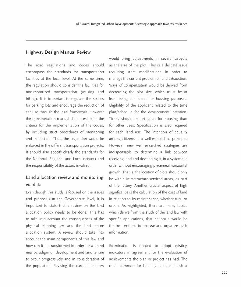
227
Al Buraimi Integrated Urban Development: A strategic approach towards resilience
Highway Design Manual Review
The road regulations and codes should
encompass the standards for transportation
facilities at the local level. At the same time,
the regulation should consider the facilities for
non-motorized transportation (walking and
biking). It is important to regulate the spaces
for parking lots and encourage the reduction of
car use through the legal framework. However
the transportation manual should establish the
criteria for the implementation of the codes,
by including strict procedures of monitoring
and inspection. Thus, the regulation would be
enforced in the different transportation projects.
It should also specify clearly the standards for
the National, Regional and Local network and
the responsibility of the actors involved.
Land allocation review and monitoring
via data
Even though this study is focused on the issues
and proposals at the Governorate level, it is
important to state that a review on the land
allocation policy needs to be done. This has
to take into account the consequences of the
physical planning law, and the land tenure
allocation system. A review should take into
account the main components of this law and
how can it be transformed in order for a brand
new paradigm on development and land tenure
to occur progressively and in consideration of
the population. Revising the current land law
would bring adjustments in several aspects
as the size of the plot. This is a delicate issue
requiring strict modifications in order to
manage the current problem of land exhaustion.
Ways of compensation would be derived from
decreasing the plot size, which must be at
least being considered for housing purposes.
Eligibility of the applicant related to the time
plan/schedule for the development intention.
Times should be set apart for housing than
for other uses. Specification is also required
for each land use. The intention of equality
among citizens is a well-established principle.
However, new well-researched strategies are
indispensable to determine a link between
receiving land and developing it, in a systematic
order without encouraging piecemeal horizontal
growth. That is, the location of plots should only
be within infrastructure-serviced areas, as part
of the lottery. Another crucial aspect of high
significance is the calculation of the cost of land
in relation to its maintenance, whether rural or
urban. As highlighted, there are many topics
which derive from the study of the land law with
specific applications, that nationals would be
the best entitled to analyse and organize such
information.
Examination is needed to adopt existing
indicators in agreement for the evaluation of
achievements the plan or project has had. The
most common for housing is to establish a

228
Part 3. Further Recommendations
relationship between housing and the market
in terms of affordability. Quantity and quality
is more subjective and its parameters need
specific contextualization.
Finally, in order for this to occur, this study
identifies the need for the following statistics
and information to be produced with the use of
geographical information systems, surveys, etc.
○ Geographical data of all land plots
allocated and whether they are developed or not,
in order to obtain a ratio between how much land
is allocated and how much land is developed
within a determinated time span. In addition
information that shows where land is developed
the fastest, with what density (people/km2), and
at what rate (time) are needed.
○ Data on where are the fastest poles of
development, regarding: housing, agriculture,
commerce and industry; in order to know where
are this activities prosperous. Likewise, similar
studies are needed for the areas where the same
activities are decreasing or even disappearing.
○ Data on where people are living and
working, studying, spending time, etc.; in order
to portray how this land allocation is fostering or
preventing livelihoods to occur.

229
Al Buraimi Integrated Urban Development: A strategic approach towards resilience
Conclusions
Integrated strategies are essential for
sustainable urban development. For the five
intersecting topics presented in this report:
regional development, transportation, service
infrastructure, housing and heritage; the
consideration on the government with its
top-down decision-making structure makes
evidence of its key contribution for hindrances
in urban management redirection.
Mechanisms to structure new criteria for the
regional development of Al Buraimi Governorate
recognize three scenarios to empower, first by
small scale actions. The objectives set are for
the city to lead the way towards a more resilient
society in economic, social and environmental
terms, for both the major city and its
surrounding town and villages. In the long-
term, improved management of public services
guarantee enhanced delivery of city systems as
living conditions and economic opportunities.
Figure 98. Agriculture
in As Sunainah
Source: (Salcedo 2015)


Annex
232
Annex
Methodological remarks
This report developed from five master
degree theseses corresponding to the Urban
Management program from the Technische
Universität Berlin. The research engaged in
writing each thesis stemmed from the joint
interest between the Governorate of Al Buraimi
and the university. The goal, to produce an
assessment of the urban condition of the city
from five specific topics: Regional development,
Transportation, Infrastructure, Housing and
Heritage.
Both empirical and theoretical methodological
approaches were utilized for the analysis in all
topics. Qualitative data from semi structured
interviews with a wide range of Governorate
Ministries and their sub-departments, official
institutions, academics, the private sector, local
population, all contributed to the development
of the five subjects. Besides this, quantitative
data obtained from governmental statistics,
site visits, photographic documentation and
mapping support the qualitative evaluation on
site.
233
Al Buraimi Integrated Urban Development: A strategic approach towards resilience
List of Institutions visited
Al Buraimi Governorate Office
Ministry of Agriculture and Fisheries Al Buraimi Branch
Ministry of Environment & Climate Affairs Al Buraimi Branch
Ministry of Housing Al Buraimi Branch
Ministry of Regional Municipalities & Water Resources Al Buraimi Branch
Ministry of Tourism Al Buraimi Branch
Ministry of Transport and Communications Al Buraimi Branch
Ministry of Transport and Communications in Muscat
Municipal Council of Al Buraimi
Oman Chamber of Commerce & Industry Al Buraimi Branch
Transit Department of the Royal Oman Police of Al Buraimi

234
Annex
Glossary
Accessibility
It is the ability to reach desired goods, services,
activities and destinations (collectively called
opportunities). Access is the ultimate goal of
most transportation, except a small portion of
travel in which movement is an end in itself
(jogging, pleasure drives), with no destination.
Bioclimatic architecture
The design of built structures considering the
local climatic context to harness thermal and
visual comfort using the natural resources
at hand the most as possible while reducing
artificial systems.
Compact city
An urban design and planning concept that
considers compactness more sustainable than
sprawl by means of high density. It aims for
closer relations and improved accessibility via
mixed land use and preference on short walking
distances. It concentrates on the human scale
dictated by community oriented guidance.
Compactness
A characteristic recognized by the tightness
of space between objects or the relations
in systems. The tight space translates to a
proximate fixed distance for all the containing
aspects.
Connectivity
The state or quality represented by the capacity
of establishing a direct link to form a closed
network. It is measurable by the density of
bonded relationships in a system or between
objects.
Density
It is the number of people or jobs per unit of
land area. It increases the proximity of common
destinations, and the number of people who
use each mode, increasing demand for walking,
cycling and transit.
Ecotourism
Is environmentally responsible travel and
visitation to relatively undisturbed natural areas,
in order to enjoy, study and appreciate nature,
that promotes conservation, has low visitor
impact, and provides for beneficially active socio-
economic involvement of local populations.
Heritage
Is that which is inherited from past generations,
maintained in the present and bestowed for the
benefit of future generation.
Inclusive Transportation Planning
It considers all significant objectives, impacts
and options. Moreover, it is integrated (decision-
making is coordinated among different sectors,
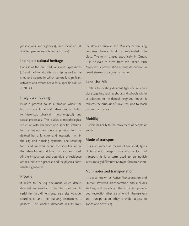
235
Al Buraimi Integrated Urban Development: A strategic approach towards resilience
jurisdictions and agencies), and inclusive (all
affected people are able to participate).
Intangible cultural heritage
Consist of the oral traditions and expressions
[…] and traditional craftsmanship, as well as the
sites and spaces in which culturally significant
activities and events occur for a specific culture.
(UNESCO).
Integrated housing
Is as a process so as a product where the
house is a cultural and urban product linked
to historical, physical (morphological) and
social processes. This builds a morphological
structure with character and specific features.
In this regard, not only a physical form is
defined but a function and interaction within
the city and housing systems. The resulting
form and function define the specification of
the urban layout and how it is read and used.
All the imbalances and potentials of residence
are related to this process and the physical form
which it generates.
Krookie
It refers to the A4 document which details
different information from the plot as its
serial number, dimensions, area, site location,
coordinates and the building restrictions it
possess. The krooki’s metadata results from
the detailed surveys the Ministry of Housing
performs before land is subdivided into
plots. The term is used specifically in Oman.
It is believed to stem from the French term
“croquis”: a presentation of brief description in
broad strokes of a current situation.
Land Use Mix
It refers to locating different types of activities
close together, such as shops and schools within
or adjacent to residential neighbourhoods. It
reduces the amount of travel required to reach
common activities.
Mobility
It refers basically to the movement of people or
goods.
Mode of transport
It is also known as means of transport, types
of transport, transport modality or form of
transport. It is a term used to distinguish
substantially different ways to perform transport.
Non-motorized transportation
It is also known as Active Transportation and
Human Powered Transportation and includes
Walking and Bicycling. These modes provide
both recreation (they are an end in themselves)
and transportation (they provide access to
goods and activities).
236
Annex
Paradigm
A theory or a group of ideas about how
something should be done, made, or thought
about.
Proximity
The concept of urban proximity requires that
cities should be built with appropriate population
and landmark density so that destinations
are reached with reduced time. This reduced
commuting allows for reduced fuel expenditure
and also opens the door to alternative means of
transportation such as bike riding and walking
Replicability
A literal and conceptual approach on the ability
of replicating or reproducing in other location
and also in a different scale. The approach can
be literal or conceptual.
Resilience
An ability to recover from or adjust easily to
misfortune or change. In the planning field
the term resilience studies human actions as
cycles that are adaptive, just as in ecology. The
interest in resilience, in acquiring this capacity
to regain the original state or form, to withstand
change or to recover quickly from a problematic;
lies in the fact that resilient planning strategies
acknowledge that this natural adaptive cycles
can be modified with planning intervention.
Responsible tourism
Is tourism which minimizes negative social,
economic and environmental impacts, generates
greater economic benefits for local people and
enhances the well-being of host communities,
improves working conditions and access to the
industry, involves local people in decisions that
affect their lives and life chances, makes positive
contributions to the conservation of natural and
cultural heritage embracing diversity, provides
more enjoyable experiences for tourists through
more meaningful connections with local people,
and a greater understanding of local cultural,
social and environmental issues, provides
access for physically challenged people, is
culturally sensitive, encourages respect between
tourists and hosts, and builds local pride and
confidence.

237
Al Buraimi Integrated Urban Development: A strategic approach towards resilience
Most relevant references
Al Gharibi, H. (2013) Urban Growth from
Patchwork to Sustainability Case Study: Muscat.
PhD Dissertation in Technische Universität
Berlin.
Anis, U. R. & Ali Fadaak, T. (1991) New towns
in Saudi Arabia. Habitat International. 15 (1/2),
167–179.
Anon (n.d.) Tangible Cultural Heritage | United
Nations Educational, Scientific and Cultural
Organization [online]. Available from: http://
www.unesco.org/new/en/cairo/culture/
tangible-cultural-heritage.
Banister, D., Pucher, J., Lee-Gosselin, M. &
Lee, M. (2007). Making Sustainable Transport
Politically and Publicly Acceptable: Lessons
from the EU, USA and Canada.
Banister, D. (2008). The Sustainable Mobility
Paradigm. Transport Policy, 15(2), 73–80.
Buerkert, A. et al. (2010) Oases of Oman:
livelihood systems at the crossroads. Muscat:
Al Roya Press & Pub. House.
Bürkert, A. et al. (2007) Times of change in
Omani oases. German Research. 29 (3), 4–9.
Christensen, T. H. (ed.) (2011b) Solid Waste
Technology & Management. Vol. 1, 2 vols.
Blackwell Publishing Ltd.
Cities Alliance (2011) Guidebook for City
Development Strategies in Southern
Mediterranean Countries | Cities Alliance.
Davoudi, S. et al. (2012) Resilience: A Bridging
Concept or a Dead End? ‘Reframing’ Resilience:
Challenges for Planning Theory and Practice
Interacting Traps: Resilience Assessment of
a Pasture Management System in Northern
Afghanistan Urban Resilience: What Does it
Mean in Planning Practice? Resilience as a
Useful Concept for Climate Change Adaptation?
The Politics of Resilience for Planning: A
Cautionary Note: Edited by Simin Davoudi and
Libby Porter. Planning Theory & Practice. 13 (2),
299–333.
DeLoG et al. (2014) How to localize targets
and indicators of the Post- 2015 agenda. The
Development Partners Working Group on
Decentralisation & Local Governance.
Firley, E. & Stahl, C. (2011) The Urban Housing
Handbook. 1st edition. Hoboken, N.J: Wiley.
238
Annex
Fox, J. W. et al. (2006) Globalization and
the Gulf. Auflage: New. London; New York:
Routledge Chapman & Hall.
Gangler, A. (2008) Oases settlements in Oman.
Stuttgart: Edition Esefeld & Traub.
Golubchikov, O. et al. (2012) Sustainable
housing for sustainable cities: a policy
framework for developing countries. Nairobi,
Kenya: UN-HABITAT.
Gössling, S. (1999) Ecotourism: a means
to safeguard biodiversity and ecosystem
functions? Ecological Economics. 29 (2),
303–320.
Hakim, B. S. (2007) Generative processes for
revitalizing historic towns or heritage districts.
Urban Design International. [Online] 12 (2-3),
87–99.
Haughton, G. & Hunter, C. (1994) Sustainable
Cities. Jessica Kingsley Publishers and Regional
Studies Association, London.
Hutton, B. (2013). Planning Sustainable
Transport.pdf.
Institutions and Sustainable Transport:
Regulatory Reform in Advanced Economies,
Cheltenham, England: Edward Elgar Publishing,
17–50.
Kenworthy, J. R. & Laube, F. B. (1996).
Automobile Dependence in Cities: An
International Comparison of Urban Transport
and Land Use Patterns with Implications
for Sustainability. Environmental Impact
Assessment Review, 16(4), 279–308.
Lamprakos, M. (2005) Rethinking Cultural
Heritage: Lessons from Sana’a, Yemen.
Traditional Dwellings and Settlements Review.
17–37.
Larice, M. & Macdonald, E. (2012) The Urban
Design Reader. Urban Reader. 2nd edition.
Routledge.
Leriche, F. & Daviet, S. (2010) Cultural
Economy: An Opportunity to Boost
Employment and Regional Development?
Regional Studies. 44 (7), 807–811.
Litman, T. (2002). The Costs of Automobile
Dependency. Victoria Transportation Policy
Institute. Retrieved November 4, 2014,
Litman, T. (2008). Well Measured. Developing
indicators for comprehensive and sustainable
transport planning. Victoria Transport Policy
Institute.
239
Al Buraimi Integrated Urban Development: A strategic approach towards resilience
Liu, Z. (2003) Sustainable tourism
development: A critique. Journal of sustainable
tourism. 11 (6), 459–475.
Markandya, A. et al. (2003) ‘Tourism and
sustainable development: Lessons from
recent World Bank experience’, in International
Conference On Tourism and Sustainable
Economic Development. 2003 pp.1–22.
McEldowney, M., Ryley, T., Scott, M. & Smyth,
A. (2005). Integrating Land-Use Planning
and Transportation in Belfast: A New Policy
Agenda for Sustainable Development? Journal
of Environmental Planning and management,
2014,
McGregor, D. F. (2005) The peri-urban
interface: approaches to sustainable natural
and human resource use. UN-Habitat.
Morton, M. Q. (2013) Buraimi: The Struggle for
Power, Influence and Oil in Arabia. London ;
New York: I. B. Tauris.
Nations, U. (2012) The State of Arab Cities
2012: Challenges of Urban Transition. Nairobi,
Kenya: United Nations Pubn.
Neto, F. (2003) ‘A new approach to
sustainable tourism development: Moving
beyond environmental protection’, in Natural
Resources Forum. 2003 Wiley Online Library.
pp. 212–222.
Newman, P. & Kenworthy, J. (1999).
Sustainability and Cities: Overcoming
Automobile Dependence. Island Press.
Retrieved November 4, 2014.Program
Development and Evaluation. (1998).
Questionnaires Design.pdf.
Owtram, F. (2004) A Modern History of Oman:
Formation of the State Since 1920. I.B.Tauris.
Petersen, A. (2009) ‘Islamic urbanism in
eastern Arabia: the case of the al-ʾAyn-al-
Buraymī oasis’, in Proceedings of the Seminar
for Arabian Studies. Papers from the forty-
second meeting of the Seminar for Arabian
Studies held in London. London: Archaeopress.
pp. 307–320.
Petersen, T. T. (2014) Review – Buraimi: The
Struggle for Power, Influence and Oil in Arabia
[online].
Phillips, W. (1972) Unknown Oman. Intl Book
Centre.
Public Authority for Electricity and Water (2013)
Annual Report 2013. Available: www.paew.gov.
om.

240
Annex
Responsible Tourism Partnership (2002) Cape
Town Declaration.
Salat, S. et al. (2011) Cities and Forms on
Sustainable Urbanism. Hermann Editeurs des
Sciences et des Arts.
Saleh, M. A. E. (2004) Planning issues in
the Middle East, an introduction. Habitat
International. [Online] 28 (4), 501–503.
Samar Damluji, S. (1998) The Architecture of
Oman. London: Garnet Publishing.
Saoud, R. (2002) Introduction to the Islamic
City.
Schiller, P. L., Brun, E. C. and Kenworthy, J.
R. (2010), An Introduction to Sustainable
Transport: Policy, Planning and
Implementation, Earthscan, London.pdf.
UN Habitat. (2013). Planning and Design for
Sustainable Urban Mobility. Global Report on
Human Settlements. Pdf
Serageldin, Ismail et al. (n.d.) In Historic Cities
and Sacred Sites: Cultural Roots for Urban
Futures
Singh, S. B. (1996) New Perspectives in Urban
Geography. M.D. Publications Pvt. Ltd.
Speece, M. (1989) Aspects of Economic
Dualism in Oman 1830–1930. International
Journal of Middle East Studies. 21 (04), 495–
515.
UN-Habitat (2010) Solid Waste Management
in the World’s Cities. Earthscan Publishing,
London, Washington DC.
United Nations World Tourism Organization
(2005) Definition | Sustainable Development of
Tourism

241
Al Buraimi Integrated Urban Development: A strategic approach towards resilience

242
Annex
Dr. Sonja Nebel
graduated in architecture and urban planning
from RWTH Aachen-Germany. She earned her
PhD at the same university. Sonja has been
teaching for more than 25 years at different
universities in Europe and in Arab Countries in
the field of urban design, urban planning and
urban conservation.
She is currently lecturer at the Urban
Management Masters Programme of Berlin
University of Technology (TU Berlin) where
she has been teaching since 2000. From 2008-
2014 she was Professor for Urban Planning
and Urban Design at GUtech Oman - German
University of Technology and principal
investigator of an interdisciplinary research
project on “Sustainable Urbanization Patterns
in Oman“. Sonja has focused for many years
on cross cultural and interdisciplinary scientific
research i.e. in Zambia, Bolivia, Thailand, China,
Syria, Oman and other Arab countries.
Furthermore, she works as a consultant within
the international development cooperation
in the field of urban development and urban
management, sustainable urban conservation,
strategic and participatory planning.
Jesús Salcedo Villanueva
graduated in architecture at the National
Autonomous University Mexico, at the Max
Cetto School and has experience on social
development projects in Mexico’s rural areas
with NGO “Natura y Ecosistemas Mexicanos
A.C.”. He is also a DAAD scholar who recently
obtained a Master of Science degree in Urban
Management at the Technische Universität Berlin
with a thesis on Omani Regional Development.
Further work includes an internship with the
Institute for Transport Research at the German
Air-Space Centre and research on the fields of
resilience and regional development.
About the authors

243
Al Buraimi Integrated Urban Development: A strategic approach towards resilience
Pedro Becerra Rodriguez
is an architect from Colombia. He has worked in
projects related to landscape architecture, design
and construction in Bogota. He has recently
obtained a Master of Science degree in Urban
Management at the Technische Universität
Berlin. During the last stage of his studies he
was selected to conduct an investigation on
sustainable transportation in Al Buraimi for the
Government of Oman.
Panagiotis Achamnos
is a civil engineer from Greece. He studied at
the National and Technical University of Athens.
He started his career in civil engineering as an
assistant civil engineer in construction sites in
Athens. He has recently obtained a Master of
Science degree in Urban Management at the
Technische Universität Berlin. He was selected
to conduct his master thesis on infrastructure
provision in Al Buraimi for the government of
Oman.

244
Annex
Florencia Carvajal S.
is an architect from Ecuador. She studied
at the Pontificia Universidad Católica in
Quito. She has built her professional career
in urban design with architecture firms in
China in addition to having independent work
experience in design-related projects. She
has recently graduated as an urban manager.
During her preparation time she participated
in the Knowledge and Innovation Community
of the European Institute of Innovation and
Technology and was selected to conduct her
master thesis on housing in Al Buraimi for the
government of Oman.
Ana Alcántara
is an architect from the Instituto Tecnológico
y de Estudios Superiores de Monterrey,
Mexico. She has been working in a Canadian-
Mexican Architecture Firm and gained
experience in the development of urban and
architectural plans. During her studies she
was CONACYT scholarship holder given by
the Mexican government. She has recently
obtained a Master of Science degree in Urban
Management at the Technische Universität
Berlin. She was selected to conduct her master
thesis on heritage sites and responsible
tourism in Al Buraimi for the government of
Oman.

245
Al Buraimi Integrated Urban Development: A strategic approach towards resilience
Panagiotis Achamnos, Pedro Becerra, Mohammed Al-Bhadi, Dr. Hammad Al Gharibi, Florencia
Carvajal, Ana Alcántara, Jesús Salcedo, Dr. Johannes Kuechler, HE Al Sayed Ibrahim Bin Said Al
Busaidi, Dr. Sonja Nebel, Dr. Bettina Hamann.


