44
ALBERT PARK AND LINTHORPE ROAD CONSERVATION AREA Appraisal and Management Plan April 2013

ALBERT PARK AND LINTHORPE ROAD CONSERVATION AREA Appraisal and Management Plan
April 2013

CONTENTS Section Content Page 1.00 Introduction 1 CONSERVATION AREA BOUNDARY 2.00 Conservation Area Boundary 2 APPRAISAL 3.00 Location and Population 3 4.00 Origins and Development 6-7 5.00 Archaeology 12 6.00 Character, Architectural Qualities, Materials & Details 13
(Street-by-Street Analysis) 14-17 7.00 Buildings that make a Positive Contribution 18 8.00 Spaces and Views 19-20 9.00 Trees and Soft Landscaping 21 10.00 Setting of the Conservation Area 23 11.00 Negative Factors 23 12.00 Neutral Factors 23 MANAGEMENT PLAN 13.00 Management Plan 24 14.00 Preservation 25-29 15.00 Enhancement 30 APPENDIX I Albert Park List Description APPENDIX II Listed Buildings APPENDIX III Local List Buildings APPENDIX IV Tree Preservation Orders REFERENCES LIST OF MAPS Map 1 - Conservation Area Boundary 4 Map 2 – Aerial photograph 5 Map 3 – Historical Development 8 Map 4 – Historic Map c.1850 9 Map 5 – Historic Map c.1890 10 Map 6 – Historic Map c.1914 11 Map 7 – Tree Preservation Orders 22
Albert Park and Linthorpe Road Conservation Area Appraisal and Management Plan
1
1 INTRODUCTION 1.01 Section 69 of the Planning (Listed Buildings and Conservation Areas) Act 1990 requires
local planning authorities to designate as conservation areas any “areas of special architectural or historic interest the character or appearance of which it is desirable to preserve or enhance”. Also from time to time authorities are required to review the extent of conservation areas within their districts.
1.02 Section 71 of the Act requires local planning authorities to formulate and publish
proposals for the preservation and enhancement of conservation areas and to submit them for consideration to a public meeting. Following designation, the local authority in exercising its planning powers, must pay special attention to the desirability of preserving or enhancing the character or appearance of the conservation area (Section 72 of the Act).
1.03 This document, in three sections, sets out the results of a study of the proposed Albert
Park and Linthorpe Road Conservation Area. The first section (Chapter 2.0) discusses the Conservation Area boundaries and recommends a number of amendments to the designated area. The second section (Chapters 3.0 to 12.0) is an appraisal of the special architectural and historic interest of the Conservation Area. The final section (Chapters 13.0 to 15.0) sets out recommendations for a Management Plan, including policies that would assist in the process of preserving and enhancing the Conservation Area.
1.04 This Appraisal and Management Plan is based on fieldwork carried out to March 2012. At
the time that the fieldwork was undertaken three development sites were under construction. These sites are identified on the maps within this document but in view of their evolving nature are not included within this appraisal.
1.05 There are a number of invaluable sources which have been used in producing the
Conservation Area Appraisal and Management Plan including Norman Moorsom’s ‘Middlesbrough’s Albert Park’, Paul Stephenson’s ‘A Short History of Middlesbrough’ and the Bulmer’s Trade Directory of 1890. Fieldwork carried out by Postgraduate Students from the School of Architecture Planning and Landscape at Newcastle University have made a important contribution to the assessment of character and the proposed boundary, under the supervision of Dr Zan Gunn.
A SUMMARY OF SPECIAL INTEREST 1.06 The character of the Conservation Area is made up of high quality open spaces, mature
trees, superior Victorian, Edwardian and 1930s housing, traditional shops, and landmark buildings, of which have a number have towers and domes which can be seen from great distances.

Albert Park and Linthorpe Road Conservation Area Appraisal and Management Plan
2
2 CONSERVATION AREA BOUNDARY 2.01 The Conservation Area Boundary is shown in Figure 1. 2.02 The northern boundary runs along Linthorpe Road up to, and including, the Yorkshire
Bank on the corner of Gresham Road. It continues to the rear of the properties on Albert Terrace and includes Park Lane.
2.03 To the east the boundary runs behind numbers 1-27 Clairville Road, and the eastern
boundary of Clairville Common. 2.04 To the south the boundary runs behind the properties on Park Road South including the
Fire Station, and includes 2-28 St Barnabas Road. The furthest extent of the boundary on Linthorpe Road southwards is 414 Linthorpe Road on the eastern side, and 411 Linthorpe Road on the western side.
2.05 To the west, the boundary runs behind St Barnabas Church Hall, Sacred Heart Parochial
Hall, and the United Reform Church Hall. The boundary continues behind the terraces at 325-373 Linthorpe Road, the Forbes Building and the Yorkshire Bank, also taking in Ayresome Gardens and School.

Albert Park and Linthorpe Road Conservation Area Appraisal and Management Plan
3
3 LOCATION AND POPULATION 3.01 Albert Park and Linthorpe Road Conservation Area is situated approximately 1.5km to the
south of Middlesbrough town centre. It is estimated that approximately 50 business and 1500 residents within the proposed Conservation Area.

Albert Park and Linthorpe Road Conservation Area Appraisal and Management Plan
4
Map 1: Conservation Area Boundary

Albert Park and Linthorpe Road Conservation Area Appraisal and Management Plan
5
Map 2: Aerial photograph and Conservation Area boundary

Albert Park and Linthorpe Road Conservation Area Appraisal and Management Plan
6
4 ORIGINS AND DEVELOPMENT
‘In the 1890’s there was still a distinct country atmosphere about the place. The last of the old laneside hedgerows, dotted with mature trees where fields were just giving way to redevelopment; the Old Cemetery represented something of a border between urban encroachments and the open fields of Oldgate Farm, in those days approached by a private driveway about to be re-constructed and named Kensington Road. The Park Gates stood in a quiet, almost rural setting with no housing westwards to Newport, where most of the farmlands of Oldgate and Ayresome Grange had become allotments, bringing revenue to the Owners of the Middlesbrough Estate, destined for eventual redevelopment, still in the future. Behind and eastwards, 70 acres of well laid-out parkland extended to the fields of Marton Grove Farm reaching out into the open, unspoiled, North Yorkshire countryside.’
(A Short History of Middlesbrough – P. Stephenson, 2002)
Figure 1: Looking northwards down Linthorpe Road with Park Methodist Church in the background c.1900
Figure 2: Looking southwards down Linthorpe Road with the Albert Park Hotel on the left of the photograph c.1900

Albert Park and Linthorpe Road Conservation Area Appraisal and Management Plan
7
4.01 Up until the 1850s this part of Linthorpe Road was rural, consisting of large fields,
interspersed with the occasional house. At this time, before industrialisation, Linthorpe was part of the ancient parish of Acklam. Linthorpe Road has been an important thoroughfare since at least the medieval period, leading from old Middlesbrough (and the site of the Priory), through to the earlier village of Linthorpe, south of the Conservation Area. A Sailor’s trod (marked on some historic maps) passes through the site of Albert Park from east to west.
4.02 Before the 1850s the cemetery is the only development in the area, and it is only when
the development of Albert Park begins in the 1860s that new buildings appeared in the area, including the park lodges, the Albert Park Hotel, workers cottages on St Barnabas Road, the Villas surrounding the park, and on Linthorpe Road. There were only six families in Park Road South in 1889 (Stephenson, P. 2002). St Barnabas and Park Methodist Churches, Ayresome School and Nazareth House orphanage we not built until around 1900. Around the same time high quality terraced housing began to appear in the area as the town of Middlesbrough development southwards, including Linthorpe Road and Clairville Road.
4.03 Due to the boulder clay, there were a number of brickworks to the south of the proposed
Conservation Area which brought with it workers housing in the mid-19th Century. The brickworks declined in the late 19th Century, and that land was reclaimed, ponds filled with ballast, and houses built upon them. The former brickworks are just outside the Conservation Area boundary.
4.04 A number of buildings in the area date from the interwar period including the Park
Presbyterian and Sacred Heart Churches, and the semi detached housing and Fire Station on Park Road South.

Albert Park and Linthorpe Road Conservation Area Appraisal and Management Plan
8
Map 3: Historic Development

Albert Park and Linthorpe Road Conservation Area Appraisal and Management Plan
9
Map 4: 1st Edition Ordnance Survey Map (c.1850)
Albert Park and Linthorpe Road Conservation Area Appraisal and Management Plan
10
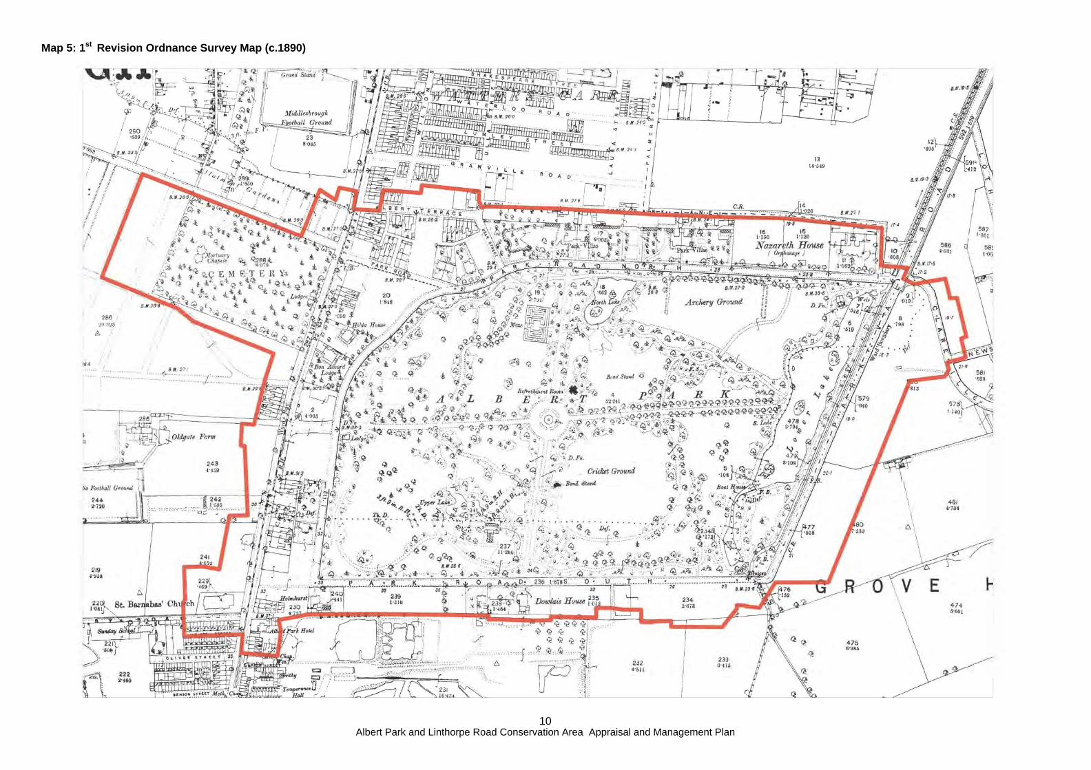
Map 5: 1st Revision Ordnance Survey Map (c.1890)

Albert Park and Linthorpe Road Conservation Area Appraisal and Management Plan
11
Map 6: 2nd Edition Ordnance Survey Map (c.1914)

Albert Park and Linthorpe Road Conservation Area Appraisal and Management Plan
12
5 ARCHAEOLOGY 5.01 Prehistoric, Roman, Anglo-Saxon and Medieval
There are no recorded archaeological sites of these periods within the study area. It is however likely that the line of Linthorpe Road was established by at least the 11th century to provide transport to the village at Middlesbrough close to the River Tees near the site of the Old Town Hall. The sailor’s trod (mentioned in paragraph 4.01) is also of note in this area.
5.02 17th century At some time in the early 17th century the landscape of this area would have become enclosed with a semi-regular pattern of fields defined by hedgerows. Some of these may survive within the park, particularly where there are fragmentary rows of hedge species such as hawthorns.

Albert Park and Linthorpe Road Conservation Area Appraisal and Management Plan
13
6 CHARACTER, ARCHITECTURAL QUALITIES, MATERIALS & DETAILS 6.01 The central section of the Conservation Area is dominated by Albert Park the character of
which is made up of a designed landscape, mature trees, and views into and out of the area. The larger buildings including the Museum and the Churches are situated on Linthorpe Road, with Nazareth house on Park Road North.
6.02 To the south of the Conservation Area is the inter war development of Park Road South,
interspersed with occasional villas, and punctuated with the Fire Station with its iconic tower. The housing is typical of the period, however they are set within large front gardens, and have boundary walls, gate piers and original windows and doors intact. There have been some unsympathetic alterations such as extensions and loss of original features, but by and large these houses are excellent examples of this type of architecture and designed with the park setting in mind with large front gardens.
6.03 The traditional materials are typical of the period of development such as red engineering
brick, some sandstone dressings, and the earlier buildings are of handmade brick as can be seen on St Barnabas Road where the bricks are unusual in Middlesb rough being mottled grey, similar to the Old Town Hall.
6.04 The character of each street and space is analysed in Chapter 7.

Albert Park and Linthorpe Road Conservation Area Appraisal and Management Plan
14
7 STREET-BY-STREET ANALYSIS 7.02 Albert Park: The character of Albert Park is
made up of the formal designed landscape covering an area of just over 71 acres (28.4 hectares). The avenues and clusters of mature trees, monuments and pathways, and views into and out of the park all contribute to it’s character. The various towers around the park are important eye catchers from within the park (although many of the towers post-date the creation of the park).
There are several buildings which were designed with their setting with ‘Park views’ being of great importance, Park Villas are the most notable. The original park buildings, East and West Lodges, are an important part of the character and appearance of the Park. This is a key open space in Middlesbrough, and provides recreational space and facilities including a lake, tennis courts, accessible paths, and pleasure grounds. The register entry can be seen in Appendix I. The historic structures are an important part of the character of the Park including the fountain, bandstand, clock and memorials. The park is of great historic interest, given to the town by Ironmaster and the town’s first Mayor, and was named in memory of Prince Albert who died in 1861, seven years before the park opened.
7.03 Albert Terrace: Large two and three storey
terraced houses with two storey bays, elegant brick door surrounds and timber canopies. Some of the properties are semi-detached, and most retain the dwarf brick boundary walls and gate piers. Many architectural features have been lost, and some properties have been rendered, but what survives is high quality. Number 46 and 48 are particularly high quality, with decorative brickwork, elaborate chimneystacks and door cases.
Figure 5: Albert Terrace
Figure 3: West Lodge and the Clock Albert Park
Figure 4: Open space in the middle of Albert Park

Albert Park and Linthorpe Road Conservation Area Appraisal and Management Plan
15
7.04 Ayresome Gardens: The character here is derived from the open space fronting onto Linthorpe Road, and the views of nearby historic buildings such as the Grade II listed Forbes Buildings adjacent, and the historic Ayresome School to the rear of the gardens. Mature trees also make an important contribution to the character of the area. The site is of historic interest as the former Ayresome Cemetery.
7.05 Clairville Road: There are a number of
interesting historic properties on Clairville Road and in the streets behind. Only the terrace, 1- 27 Clairville Road, is included in the Conservation Area due to the high quality of the surviving historic fabric and the relationship with Albert Park. The houses have small balconies and decorative metal railings to the first floor between two storey bays. Some original doors and sliding sash windows with leaded lights survive, but many have been replaced with PVC-u. The properties have small front gardens with low brick walls. Some original gate piers survive which add great character to the Streetscene.
7.06 Linthorpe Road: A small section of
Linthorpe Road has been included in the Conservation Area. Despite a number of recent developments, such as medical centres, this part of Linthorpe Road retains some high quality Victorian buildings, and concentration of landmark buildings such as the churches and the Dorman Museum. Whilst alterations which are detrimental to the character of the area have taken place, a large number of architectural features, and historic buildings survive. Shop buildings on Linthorpe Road are largely 2 ½ storey terraces with bay windows above the shop front. Some original shop fronts survive in the buildings opposite the Dorman Museum. These terraces of shops are interspersed by larger buildings such as the former bakery, the Forbes Building, the many churches, the Albert park Hotel and the Dorman Museum. In addition to the smaller commercial terraces, former houses on the east side of Linthorpe Road, adjacent to Sacred Heart Church survive. These are large 21/2 storey terraces with two
Figure 8: Linthorpe Road looking north
Figure 9: Shops on Linthorpe Road
Figure 7: Clairville Road
Figure 6: Entrance into Ayresome Gardens
Albert Park and Linthorpe Road Conservation Area Appraisal and Management Plan
16
storey bays, large door surrounds and detailed hood moulds. 7.07 Park Lane: There is little character to Park Lane compared to the rest of the
Conservation Area. The section of Park Lane included in the Conservation Area contains mature trees and a detached building, adjacent to large gate piers, which appears to have been linked with Park Villas.
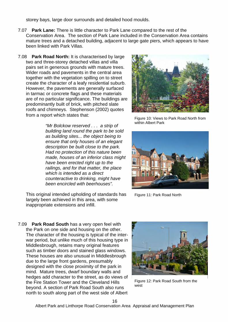
7.08 Park Road North: It is characterised by large
two and three-storey detached villas and villa pairs set in generous grounds with mature trees. Wider roads and pavements in the central area together with the vegetation spilling on to street create the character of a leafy residential suburb. However, the pavements are generally surfaced in tarmac or concrete flags and these materials are of no particular significance. The buildings are predominantly built of brick, with pitched slate roofs and chimneys. Stephenson (2002) quotes from a report which states that:
“Mr Bolckow reserved . . . a strip of building land round the park to be sold as building sites... the object being to ensure that only houses of an elegant description be built close to the park. Had no protection of this nature been made, houses of an inferior class might have been erected right up to the railings, and for that matter, the place which is intended as a direct counteractive to drinking, might have been encircled with beerhouses”.
This original intended upholding of standards has largely been achieved in this area, with some inappropriate extensions and infill.
7.09 Park Road South has a very open feel with the Park on one side and housing on the other. The character of the housing is typical of the inter-war period, but unlike much of this housing type in Middlesbrough, retains many original features such as timber doors and stained glass windows. These houses are also unusual in Middlesbrough due to the large front gardens, presumably designed with the close proximity of the park in mind. Mature trees, dwarf boundary walls and hedges add character to the street, as do views of the Fire Station Tower and the Cleveland Hills beyond. A section of Park Road South also runs north to south along part of the west side of Albert
Figure 12: Park Road South from the west
Figure 11: Park Road North
Figure 10: Views to Park Road North from within Albert Park

Albert Park and Linthorpe Road Conservation Area Appraisal and Management Plan
17
Park and includes two former villas, one of which is now the presbytery to Sacred Heart Church. Park Road South also includes views of the well-designed rear of Sacred Heart Church.
7.10 Park Vale Road: There are no buildings on
this stretch of Park Vale Road, and the character of the area is made up of the open space on Clairville Common and views into the Park.
7.11 St Barnabas Road: Some of the earliest
buildings in the Conservation Area are on St Barnabas Road. Of grey mottled, hand made brick, the have red brick string courses, elaborate timber door surrounds and are unique in character. St Barnabas Church and it’s grounds provides attractive entrance to the Conservation Area from the south.
Figure 14: St Barnabas Road
Figure 15: St Barnabas Church
Figure 13: Park Vale Road

Albert Park and Linthorpe Road Conservation Area Appraisal and Management Plan
18
8 BUILDINGS THAT MAKE A POSITIVE CONTRIBUTION 8.02 The range of listed buildings (see Appendix II) make a huge contribution to the
character of the Conservation Area, and those with towers contribute to the wider townscape also. Listed buildings within the Conservation Area include Park Methodist and Sacred Heart Church, the Dorman Museum, Nazareth House on Park Road North, West Lodge in Albert Park and structures such as the Cenotaph, War Memorial and Clock, in and around the Park.
8.03 Local List buildings also make an important contribution to the character of the area and
range from the United Reform Church, to the terrace of shops on Linthorpe Road. 34 Park Road North is locally listed as an excellent example of the villas looking over the park, East Lodge within Albert Park is included on the local list for architectural interest, townscape value, and group value alongside the West Lodge which is Grade II listed.
8.04 There are a number of other buildings which are not listed or locally listed which also
make an important contribution to the character of the Conservation Area. The terrace on Clairville Road has a consistency of style and quality with Oxford Road in Linthorpe Conservation Area. Park Villas (now part of the University Campus) are large former dwellings set overlooking Albert Park, whilst their symmetry and character has been altered by inappropriate extensions, they still make an important contribution to the character and historic interest of the of Conservation Area. Due to the consent for demolition approved in 2010, the Fire Station on Park Road South has not been included on the Local List, however, it is felt the training tower in particular makes a very important contribution to the character of the area.

Albert Park and Linthorpe Road Conservation Area Appraisal and Management Plan
19
9 SPACES AND VIEWS 9.02 The majority of the open space within the area is
formed by pubic open space, Albert Park, Clairville Common and Ayresome Gardens. There is also a great deal of open space in private gardens on Park Road North and South. Mature trees are an important feature of the character of the area and soften the urban landscape. The open spaces in the Conservation Area are so important for recreational use, particularly at the weekends, for residents and visitors alike.
9.03 Views into the Conservation Area are
concentrated along the highway network. From within the Park views are largely framed by iconic buildings or trees in the Park.
9.04 There are significant views throughout the
Conservation Area including: North and south through along Linthorpe
Road; South along Linthorpe Road, the views of
the Dorman, the setting of the Cenotaph, ornamental gardens and the park gates come into view at the junction with Ayresome Road and Linthorpe Road. From here the views of the Dorman Museum and church towers are important;
North up Linthorpe Road on entering the Conservation Area, the views of the towers at Sacred Heart and Park Methodist Church are important;
From Albert Park looking outwards, particularly along the avenues;
From Park Vale Road into the Conservation Area. This is a tree-lined designed view, opening out at the junction of Park Road North affording views of the East Lodge and the open space at Clairville common; and,
From Park Vale Road to Clairville Road. The views through the trees to the terrace on Clairville Road are important.
Figure 18: Views along Linthorpe Road (Sacred Heart Church in the foreground)
Figure 17: Views northwards along Linthorpe Road - with Park Methodist Church in the centre of the photograph
Figure 16: Open spaces are important to the character of the Conservation Area

Albert Park and Linthorpe Road Conservation Area Appraisal and Management Plan
20
9.05 Views of the surrounding historic buildings, and associated towers are important to the character of the Conservation Area, enclosing the park within its urban setting. Buildings outside the Conservation Area, such as St Joseph’s church tower, and out to the Cleveland Hills beyond, are also important.
Figure 20: Views outside the Conservation Area are also important (St Joseph’s Church tower)
Figure 19: Views from within Albert Park

Albert Park and Linthorpe Road Conservation Area Appraisal and Management Plan
21
10 TREES AND SOFT LANDSCAPING 10.02 The Conservation Area has large areas of
open space with many trees and other soft landscaping. Within the area there are 79 Tree Preservation Orders (Map 7) for single or groups of trees located in gardens and grounds of the University Campus on Park Road North and Park Lane. See Appendix IV for details of the Tree Preservation Orders in the Conservation Area.
10.03 Within the Conservation Area there are many
important groups of trees, including those on Clairville common, and groups within Albert Park and Ayresome Gardens. All these trees are an important feature of the area and establish its character.
Figure 21: Trees are fundamental to the character of Albert Park
Figure 22: Trees on the edge of the Park also make a very important contribution to the streetscene
Figure 23: Trees outside the park (such as these on the edge of Clairville Common) contribute to the character of the Conservation Area

Albert Park and Linthorpe Road Conservation Area Appraisal and Management Plan
22
Map 7: Tree Preservation Orders

Albert Park and Linthorpe Road Conservation Area Appraisal and Management Plan
23
11 SETTING OF THE CONSERVATION AREA 11.02 The Conservation Area is generally surrounded by a combination of Victorian terraced
housing and later 1930s housing, which is of more limited interest. Linthorpe Road, both north and south of the Conservation Area, is an important part of the setting of the Conservation Area, so too is the approach on the tree lined Park Vale Road.
12 NEGATIVE FACTORS 12.02 There are a number of negative features of the Conservation Area including the
buildings on the corner of Park Road South and Linthorpe Road, Robertswood apartments on Park Road South, and the infill development on Park Road North. The Porthole Café, just outside the Conservation Area boundary, does not reflect the character of the area.
12.03 There are a number of alterations to the terrace on Linthorpe Road (325-337), where
the buildings have been extended to the front having a negative impact on the architectural interest of the building.
13 NEUTRAL FACTORS 13.02 In addition to the negative factors noted in
the previous section, there are also a number of neutral areas and factors within the Conservation Area. Neutral factors include Albert Gate Apartments on Park Road South and the new Doctor’s Surgery on Linthorpe Road. These neutral factors neither detract from, nor enhance the character of the Conservation Area.
Figure 24: Albert Gate Apartments have a neutral impact on the character of the Conservation Area.

Albert Park and Linthorpe Road Conservation Area Appraisal and Management Plan
24
14 MANAGEMENT PLAN 14.02 This section sets out a possible management plan for Albert Park and Linthorpe Road
Conservation Area. These proposals should be read in conjunction with the appraisal of the designated area, set out in the previous Chapters.
14.03 The proposed policies and recommendations are intended to preserve the character
and appearance of the Conservation Area, assist in managing change without compromising the historic environment and make proposals for its enhancement. In order to implement these policies they would need to be incorporated in either the Local Plan or the Local Development Framework.
14.04 Conservation area designation reduces permitted development rights and the
following policies apply:- The National Planning Policy Framework
Section 12: Conserving and Enhancing the Historic Environment English heritage: PPS 5 Planning Practice Guide
Middlesbrough Local Development Framework Core Strategy
CS4 SUSTAINABLE DEVELOPMENT All development will be required to contribute to achieving sustainable development principles by, where appropriate: K protecting and enhancing Middlesbrough’s historic heritage and townscape character L delivering development of a high quality design that contributed to improvements in the quality of townscape. CS5 DESIGN All development proposals will be required to demonstrate a high quality of design in terms of layout, form and contribution to the character and appearance of the area. Proposals will be required to contribute to achieving the following: A enhancement of the best characteristics of Middlesbrough’s build environment to create a positive identity for the town and improve the quality of life of its population; F ensuring a quality of new development that enhances both the built and natural environments: H the preservation or enhancement of the character or appearance of conservation areas and other areas of special interest and character; I Safeguarding buildings identified as being of special historic or architectural interest, and ensuring that any adaptation or reuse is undertaken sympathetically and protect, or, where possible, enhances, the special characteristics of the building;
Albert Park and Linthorpe Road Conservation Area Appraisal and Management Plan
25
15 PRESERVATION 15.02 The Planning (Listed Buildings and Conservation Areas) Act 1990 and other planning
legislation contain various powers that assist local planning authorities with their responsibility to preserve the character and appearance of conservation areas.
Demolition of buildings 15.03 14.02 Section 74 of the Act provides for control over the demolition of buildings in
conservation areas (subject to various exceptions). The National Planning Policy Framework (NPPF) states that ‘Significance can be harmed or lost through alteration or destruction of the heritage asset or development within its setting. As heritage assets are irreplaceable, any harm or loss should require clear and convincing justification.’
15.04 Buildings which make a positive contribution are generally the churches, Museum,
Orphanage, large detached villas, villa pairs and terraces constructed in the nineteenth and early twentieth century, and the interwar housing which establish the character of the conservation area. There should be a presumption against the demolition of any of these buildings.
Policy: The Council will only grant conservation consent for the demolition of a building
that makes a positive contribution to the townscape of the Conservation Area if it has been fully justified against the criteria laid out in the NPPF.
15.05 In addition, the Conservation Area includes several listed buildings (see Map 6), the
demolition and alteration of which is controlled by the provisions of the Planning (Listed Buildings and Conservation Areas) Act 1990.
Local List 15.06 The appraisal identified that there are a number of buildings in the Conservation Area
included on the Council’s Local List of buildings and sites of local importance. Many of these buildings are iconic local landmarks, and make a very important contribution to townscape and sense of place.
Policy: External alterations or extensions to locally listed buildings will only be permitted
where the proposals are in keeping with architectural and historic character and the appearance of the original building.
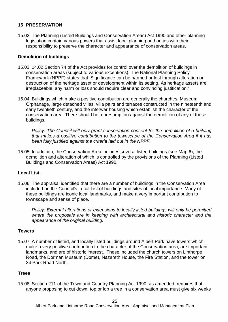
Towers 15.07 A number of listed, and locally listed buildings around Albert Park have towers which
make a very positive contribution to the character of the Conservation area, are important landmarks, and are of historic interest. These included the church towers on Linthorpe Road, the Dorman Museum (Dome), Nazareth House, the Fire Station, and the tower on 34 Park Road North.
Trees 15.08 Section 211 of the Town and Country Planning Act 1990, as amended, requires that
anyone proposing to cut down, top or lop a tree in a conservation area must give six weeks

Albert Park and Linthorpe Road Conservation Area Appraisal and Management Plan
26
notice to the local planning authority. The purpose of this requirement is to give the authority an opportunity to make a tree preservation order.
15.09 Trees make an important contribution to the character and appearance of the
Conservation Area and to its setting. Only some are covered by tree preservation orders but it is recommended that the Council undertake a comprehensive tree survey of the whole of the Conservation Area, plus it’s setting, to determine whether additional tree preservation orders are required.
Policy: The Council will generally resist proposals to cut down, top or lop a tree in the Conservation Area. Open Spaces and Gardens 15.10 The open space within the Conservation Area is formed by a number of public open
spaces such as Albert Park, Clairville Common and Ayresome Gardens. Open space is also found in private gardens and other private grounds associated with various organisations such as Teesside University. The latter areas of open space are identified on Map 7. In the Local Development Framework the Albert Park and Ayresome gardens are defined as Primary Open Space, and Clairville Common as Secondary Open Space.
15.11 The character of the area is partly established by the pattern of past development,
which generally consists of substantial houses in large plots. Proposals for re-development should maintain the ratio of built-form (footprint and volume) to plot size that is typical of the area.
Land Use 15.12 The character of the Conservation Area relies upon the existing pattern of land uses.
Any major changes to these land uses will affect this character. Policy: The Council will resist proposals that would result in the over-development of
plots and loss of gardens to the detriment of the character of the Conservation Area. Policy: The Council will generally resist proposals for the change of use of existing
residential land or buildings within the Conservation Area. 15.13 In order to retain the character of the area it is recommended that any original shop
fronts in the local centre should be retained. Policy: Where change of use to other commercial uses is accepted any original shop
fronts should be retained or a new shop front of an appropriate design provided.

Albert Park and Linthorpe Road Conservation Area Appraisal and Management Plan
27
Minor Alterations 15.14 Any work that materially affects the external appearance of a building requires planning
permission, subject to “permitted development” rights. Under normal planning control certain works are classified as “permitted development” and do not require planning permission. This includes small alterations and extensions to dwelling houses, the erection of buildings, enclosures or pools required for a purpose incidental to the enjoyment of a dwelling house (such as a swimming pool), the provision of hard surfaces, and the erection of and alterations to boundaries.
15.15 Within conservation areas some developments (that in other areas would be “permitted
development”) are not classified as “permitted development”. This includes various types of cladding; the insertion of dormer windows; and the erection of satellite dishes on walls, roofs and chimneys fronting a highway. Also, within conservation areas the size of extensions that may be erected without specific planning permission is more restricted.
15.16 The traditional materials used for the external walls of the buildings establish the
appearance of the Conservation Area. These are primarily brick and render. It is important to retain the consistency and unity of buildings that were designed as either a pair or terrace by resisting proposals to render, paint or otherwise alter parts of a designed group.
Policy: The Council will resist all proposals to clad buildings with materials that are not appropriate to the appearance of the Conservation Area or which will adversely affect
the appearance of any pair or group of buildings in the Conservation Area. 15.17 Small dormer windows with either a pitched slate roof or lead clad vault are a feature of
some of the larger buildings such as Nazareth House, and also many of the shops on Linthorpe Road, however, the introduction of inappropriate dormers of either a large-scale or non-traditional design should be resisted.
Policy: The Council will generally resist all proposals that involve the construction of
inappropriate large or non-traditional dormer windows. 15.18 The widespread erection of satellite dishes and radio equipment on buildings would
have a detrimental impact on the appearance of the Conservation Area. Policy: The Council will generally resist all proposals that involve the erection of satellite
dishes and radio equipment in prominent locations, such as roadside frontages, within the Conservation Area.
15.19 Extensions can be detrimental to the appearance of buildings either because of their
location, size or design. Extensions (including porches and canopies) on the front or principal elevations of buildings should be avoided as these elevations have usually been carefully designed. Extensions at the side or rear are generally to be preferred, except where these elevations have also been carefully designed or are open to public view.
15.20 Extensions should be subordinate to the building to which they are attached, should use
similar or complimentary materials, and should reflect or compliment its style and appearance.

Albert Park and Linthorpe Road Conservation Area Appraisal and Management Plan
28
Policy: The Council will resist proposed extensions that are over-large, in a prominent location, or are otherwise detrimental to the character of the building to which they are attached or to the character or appearance of the wider Conservation Area.
Article 4 Directions 15.21 Local planning authorities may remove (or apply for approval to remove) “permitted
development” rights by way of an Article 4 Direction. This means that certain developments that previously did not require a planning application to be submitted, would be bought under the control of the Council and now require planning permission.
15.22 The existence of and the detailed design of porches, canopies and verandahs is an
important feature of the Conservation Area and therefore the development of new features or alteration to existing should be carefully considered. The effect of the alterations and extensions that are possible under “permitted development” rights, such as the erection of extensions, the creation of hardstandings, and the removal of boundary walls, have already damaged the character and appearance of the Conservation Area. The accumulative effect of further alterations of this nature will seriously erode the special interest of the area, which is the reason for its designation.
15.23 It is therefore recommended that the Council consider an Article 4 Direction removing
the following “permitted development” rights set out in Part 1 of Schedule 2 of the Town and Country Planning General Development Order 1995, as amended, from all houses within the Conservation Area:
Class A - The enlargement, improvement or other alteration of a dwelling house, Class D - The erection or construction of a porch, Class E - The provision of a building or enclosure, swimming or other pool required for a purpose incidental to the enjoyment of a dwelling house, Class F - The provision within the curtilage of a dwelling house of a hard surface,
and Class G - The provision within the curtilage of a dwelling house of a container for the
storage of oil for domestic heating. 15.24 If such an Article 4 Direction were to be made the following policies would be possible. Policy: The Council will resist all proposals for extensions and alterations to dwelling
houses and the erection of buildings and structures within the curtilage of dwelling houses that would be detrimental to the character of the building or to the character or appearance of the wider Conservation Area.
Policy: The Council will resist all proposals for the formation of a hard surface within the
front gardens of dwelling houses that would be detrimental to the character or appearance of the wider Conservation Area.
Policy: The Council will resist the replacement of timber doors and windows which would
affect the appearance of the building, where the proposal would be detrimental to the character and appearance of the building or to the wider Conservation Area.
Albert Park and Linthorpe Road Conservation Area Appraisal and Management Plan
29
Policy: The Council will generally resist proposals to paint any buildings which were not originally designed to be painted, where the proposal would be detrimental to the character or appearance of the building or to the character or appearance of the wider
Conservation Area. 15.25 It is also recommended that the Council consider an Article 4 Direction removing the
following “permitted development” rights set out in Part 2 of Schedule 2 of the Town and Country Planning General Development Order 1995, as amended, from all residential properties within the Conservation Area:
Class A – The erection, construction, maintenance, improvement or alteration of a
gate, fence, wall or other means of enclosure. Class B - The formation, laying out and construction of a means of access to a
highway.
15.26 If such an Article 4 Direction were to be made the following policies would be possible. Policy: The Council will resist all proposals for alterations to (including demolition of)
boundary walls, gate piers, fences and gates that would be detrimental to the character or appearance of the Conservation Area.
Policy: The Council will resist all proposals for the creation of new accesses to the
highway that would be detrimental to the character or appearance of the Conservation Area.
Development Opportunities 15.27 Within the Conservation Area all proposals for development are opportunities to
enhance the character and appearance of the designated area. It is therefore important for full details (including detailed plans, sections, elevations and landscape proposals) to be available as part of a planning application.
Policy: The Council will not consider an application for planning permission for development within the Conservation Area unless it includes full details of the proposal.
Policy: The Council will expect any proposal for a development within the Conservation Area to be supported by a Design Statement which should include a full analysis of the surrounding area. Proposals should respond to the surrounding development in terms of scale, height, massing, alignment and materials. All proposals should enhance the character and appearance of the Conservation Area.
Trees 15.28 Trees are a particular feature of the Conservation Area but they mature and die.
Therefore every effort should be made to provide for new and replacement tree planting within new developments.
Policy: The Council will encourage the planting of new and replacement trees where appropriate as part of all developments within the Conservation Area.
15.29 Also, it is recommended that the Council should consider the maintenance and
replacement of the trees within the pavements.

Albert Park and Linthorpe Road Conservation Area Appraisal and Management Plan
30
16 ENHANCEMENT Boundary walls and hedges 16.02 Boundary walls and hedges are also features of the Conservation Area on Park Roads
North and South, and Clairville Road, but they have been removed from some properties. Every opportunity should be taken to provide or restore walls and/or hedges to property boundaries. It is recommended that the Council produce a design guide for boundary walls and fences in the Conservation Area.
Policy: The Council will encourage the provision and/or reinstatement of boundary walls,
railings and/or hedges. Reinstatement of features 16.03 Many of the buildings within the Conservation Area have lost their original doors,
windows and other features. As a result their character has been eroded, together with that of the wider area. As proposals come forward for alterations and extensions to these buildings there may be an opportunity to encourage the reinstatement of such features.
Policy: The Council will encourage the reinstatement of doors, windows and other features to reflect their original pattern and materials.
16.04 In order to encourage the reinstatement or repair of original features, it is recommended
that the Council consider sources of financial support for works to reinstate or repair original features.
Commercial Frontages 16.05 There are many commercial frontages on Linthorpe Road. Some of these have poorly
considered shop fronts and signage, such as the off-license and take away, which detract from the character and appearance of the area. It is recommended that the Council consider sources of financial support for works to reinstate or repair traditional shop fronts.
Street furniture 16.06 An important feature of the area are the views along pavements and roads which are
simply defined by the boundary walls to the buildings. It is recommended that the Council prepare design guidance for appropriate street furniture in the Conservation Area.

Albert Park and Linthorpe Road Conservation Area Appraisal and Management Plan
1
Appendix I Albert Park List Entry Description Grade: II (Registered Park and Garden) A public park designed by William Barratt of Wakefield and opened in 1868, with war memorial entrance screen walls and a cenotaph of 1922. HISTORIC DEVELOPMENT The idea of creating a public park in Middlesbrough was raised in the Borough Council in 1859, but no immediate action was taken. In 1864, a local industrialist, Henry Bolckow, bought land off Linthorpe Road and presented it to the Council for use as a public park. An agreement drawn up between Bolckow and the Council in 1865 specified that the park should be called Albert Park and that £3000 should be spent on laying it out. Work commenced in 1865 to a design by William Barratt, using trees and shrubs from his nursery in Wakefield. A plan of the park design of 1868 shows the proposals and a plan of 1875 probably reflects the executed layout. DESCRIPTION Albert Park is situated c 1.5km south of the centre of Middlesbrough on the east side of Linthorpe Road, in an area which is predominantly residential. The c 29ha park is on level land which falls away to the east at the extreme eastern end of the site. The park is enclosed by railings, probably of mid C20 date, on all but the east side where there is a stone wall. It is bounded by roads called Park Road North, Park Vale Road, and Park Road South. ENTRANCES AND APPROACHES The principal entrance is from Linthorpe Road to the west, where there is a forecourt flanked by lawns and a central war memorial in the form of a cenotaph which is aligned with the main gates. The entrance is flanked by walls of Portland stone surmounted by urns with inset bronze plaques bearing the names of the dead (Brierly & Rutherford 1922, walls and cenotaph listed together grade II). The entrance with screen walls replaced walls and ornamental ironwork gates which were the gift of Bolckow. The gates erected in 1922 were found to be unsafe in 1978 and were removed, finally being replaced in 1982. The Dorman Museum (1901-4, listed grade II) lies on the south side of the forecourt. It was set up as a natural history museum and memorial to the men of the 3rd Battalion Yorkshire Regiment, and the grounds around it were laid out (and subsequently maintained) by the Park Committee in 1904. West Lodge (C J Adams 1866, listed grade II) is situated within the park immediately to the south of the main entrance. Attached to the west side is a wall with a plaque commemorating the opening of the park and a niche for a bust of Bolckow which has been removed. A second entrance at the north-east tip of the park has a lodge called East Lodge which was built in 1871; this is set close to the shore of Lower Lake c 50m south-west of the entrance. There are entrances at each end of the north/south axial path; that to the north has stone gate piers, and the southern one has brick gate piers of C20 date. There are a number of other informal entrances to the park. GARDENS AND PLEASURE GROUNDS Albert Park is roughly rectangular in shape and it is divided into quadrants by axial paths. A large lake, called Lower Lake, lies along the extreme eastern side of the park. The main entrance leads to the West Walk, which was originally lined with Wellingtonias planted by

Albert Park and Linthorpe Road Conservation Area Appraisal and Management Plan
2
Bolckow and other dignitaries at ceremonial tree plantings at the park's inception. These have been replaced by horse chestnut trees, many of which have plaques beneath them recording ceremonial plantings to commemorate national and local events during the 1930s. A cast-iron clock of c 1900 (listed grade II) is situated c 30m east of the entrance alongside the Walk, and c 20m east of this is a stone sundial (1876, listed grade II). A South African War Memorial (1904, listed grade II) in the form of an obelisk on a pedestal lies alongside the Walk c 120m east of the entrance. At the point at which the axial paths cross there is a circular area with a fountain, erected in 1869 and altered and repaired in the late C19 and C20. This area was designated by Barrett for the display of sculptures, though none was erected. The Walk continues eastwards as East Walk, which is also lined with horse chestnuts, as it was in 1881 (Moorsom 1997). At the eastern end of the Walk steps lead down to the shore of Lower Lake. There are views of the lake with the largest of its islands along most of the length of East Walk. South Walk is planted with a C20 avenue of ornamental cherry trees and North Walk is flanked by planting which includes some cherries. The North and South Walks were called the Italian Gardens in the C19 and were planted with floral bedding backed by a screen of shrubs and trees. An intricate pattern of beds is shown on the 1868 plan alongside the Walks. A sinuous perimeter path links the axial paths, much as shown on the 1868 plan, apart from the section along the north-east quadrant which follows a fairly straight route, as shown on the 1875 plan. The area between this path and the park wall is shown thickly planted on the C19 plans and OS maps. The planting is now represented by scattered trees at various stages of maturity, and some areas of thicker planting, including a row of Turkey oaks along the perimeter path in the north-east quadrant. The north-west quadrant of the park is largely occupied by sports facilities, with tennis courts to the west and bowling greens to the east. A tennis court which lies c 50m north-east of the main entrance is on the site of a bowling green shown on the 1875 plan, and two more tennis courts to the north of this were constructed in the mid and late C20. A large pavilion of late C20 date lies on the east side of the northernmost court. A bowling green on the south-east side was constructed in 1913, and another to the north in 1948, on the site of a croquet ground and a maze. These features are shown on the 1868 plan c 250m and 300m north-east of the main entrance respectively. The north-east quadrant has informal playing fields on the north-west side in an area where the small North Lake, shown on the 1875 plan, was situated. This was constructed in 1869, extended in 1878, and finally filled in in 1951. Immediately east of the lake was an archery ground, also shown on the 1875 map, which had been taken over for use as a football pitch by 1876, with Middlesbrough Football Club playing its first match there in 1877 (Moorsom 1997). To the south of this there is an area of planted mounds which would have commanded views of the lake and were probably formed from spoil generated by the excavation of the lakes. The largest of these is called Bell Hill because it was once the site of the bell rung to signal park closing time. A path known as the Swiss Walk led through this area and is faintly discernible as a track. There is a late C20 fenced children's playground between the mounds and the East Walk, and a miniature golf course, opened in 1950, on the north-east side of the quadrant which is bounded by a hedge and railings. Lower Lake runs along most of the eastern side of the park. It is stone lined with an irregular elongated shoreline which is followed by paths. Three islands are shown on the 1894 OS map, but only the two to the north appear on the 1875 plan. At the southern tip of the lake is a fenced area of tarmac which was formerly a playground. The lake originally extended along the west side of this area but this part of it was filled in during the late C20. A pavilion of 1955 overlooks the lake from the south end of the western banks and a late C20 boathouse, also on the western shore, lies immediately south of the precincts of East Lodge. The lake was formed

Albert Park and Linthorpe Road Conservation Area Appraisal and Management Plan
3
by damming the Marton West Beck, which runs as an overflow along a diverted course between the eastern lakeside walk and the boundary wall. The south-east quadrant consists mainly of grassland with clumps of trees and shrubs encircling an area of open grassland formerly used as a cricket pitch which is shown on the 1868 maps and subsequent maps through to 1915. In the north-east corner, immediately behind the lakeside pavilion, there is a roller-skating rink of 1947, fenced and screened by hedges and surrounded by low terraced seating areas. The south-west quadrant also consists mainly of lawns with a network of curving paths running through them. In the south-east corner there is a maintenance yard surrounded by a fence and screened by planting. This was occupied by nurseries shown on the 1894 OS map. Immediately north of this area was a lake, called Upper Lake or Cannon Lake, which is shown on the 1868 plan. The lake was ornamented by a number of rustic stone arches, including the remains of a Norman archway, and a cannon captured during the Crimean War stood on its north shore. The lake was filled in and its associated structures removed in 1947. In the north-west corner of the quadrant there is a lake crossed by bridges and overlooked by rockeries; this feature was created during the 1980s. REFERENCES G Chadwick, The Park and the Town (1966), p 109 H Conway, People's Parks (1991), pp 102-03 N Moorsom, Albert Park, Middlesbrough, (report for Middlesbrough Borough Council 1997) Maps (reproduced in Moorsom 1997) Conveyance plan, 1867 Plan of Albert Park, 1868 Plan of Albert Park, 1875
OS 25" to 1 mile: 1st edition published 1894 2nd edition published 1915 1929 edition

Albert Park and Linthorpe Road Conservation Area Appraisal and Management Plan
2
© Crown Copyright and database right 2012. All rights reserved. Ordnance Survey Licence
number 100019088.

Albert Park and Linthorpe Road Conservation Area Appraisal and Management Plan
3
Appendix II: Listed Buildings in Albert Park and Linthorpe Road Conservation Area
No. Photographs Building name & address Grade (date)
Current use (Previous use)
1.
Forbes Buildings, Linthorpe Road II (1899-1900)
Shopping Arcade (Bakery with shops and offices)
2.
Church of the Sacred Heart, Linthorpe Road II (1931-32)
Roman Catholic Church
3.
Park Methodist Church, Linthorpe Road II (1903 –05)
Residential apartments (Wesleyan Church, Night-club)
4.
Dorman Museum II (1901-04)
Museum
5.
Dorman Museum, Roman Coffin II

Albert Park and Linthorpe Road Conservation Area Appraisal and Management Plan
4
6.
Cenotaph with memorial gates, gate piers and screen wall, Albert Park II (1922)
7.
West Lodge, Albert Park II (1866)
Vacant (Park Lodge)
8.
Memorial Clock, Albert Park II (c.1900)
9.
Sundial, Albert Park II (1876)

Albert Park and Linthorpe Road Conservation Area Appraisal and Management Plan
5
10.
South African Memorial, Albert Park II (1904)
11.
Nazareth House gates, gate piers and walls, Park Road South II (1904-05 / 1894)
Home for the elderly (Girls School & Chapel)
12.
Gate Piers Nazareth House, Park Road South II (1905)
13.
Church of St. Barnabas II (1888/1892)
Church of England Church

Albert Park and Linthorpe Road Conservation Area Appraisal and Management Plan
6
Appendix III: Locally Listed Heritage Assets in Albert Park and Linthorpe Road Conservation Area
No. Photographs Building name & address
Current use (Previous use)
1.
East Lodge, Albert Park (1867)
Middlesbrough Sea Cadets Headquarters
2.
Linthorpe United Reform Church (Park Presbyterian Church) (1923)
United Reform Church
3.
The Park Public House (Albert Park Hotel) (c.1868)
Public House
4.
34 Park Road North (1879)
Sheltered Housing (Villa for Alderman Thomas Keay)
5.
353-359 Linthorpe Road (opposite Dorman Museum) (c.1890-1900)
Shops and accommodation

Albert Park and Linthorpe Road Conservation Area Appraisal and Management Plan
7
Appendix IV: Tree Preservation Orders
TREE NO. DESCRIPTION
0369 Lime (Tilia) 0370 Cherry (Prunus) 0371 Purple Plum (Prunus) 0372 Lime (Tilia) 0373 Poplar (Populus) 0374 Holly (Ilex) 0375 Whitebeam (Sorbus) 0376 Willow (Salix) 0377 Sycamore (Acer) 0378 Sycamore (Acer) 0379 Sycamore (Acer) 0380 Grey Poplar (Populus) 0381 Grey Poplar (Populus) 0382 Grey Poplar (Populus) 0383 Willow (Salix) 0384 Sycamore (Acer) 0385 Sycamore (Acer) 0386 Whitebeam (Sorbus) 0387 Poplar (Populus) 0388 Sycamore (Acer) 0389 Sycamore (Acer) 0390 Hawthorn (Crataegus) 0391 Sycamore (Acer) 0392 Yew (Taxus) 0393 Sycamore (Acer) 0394 Whitebeam (Sorbus) 0395 Horse Chestnut (Aesculus) 0396 Poplar (Populus) 0397 Beech (Fagus) 0398 Whitebeam (Sorbus) 0399 Norway Maple (Acer) 0400 Whitebeam (Sorbus) 0401 Holly (Ilex) 0402 Whitebeam (Sorbus) 0403 Purple Beech (Fagus) 0404 Horse Chestnut (Aesculus) 0405 Lime (Tilia) 0406 Poplar (Populus) 0407 Sycamore (Acer) 0408 Sycamore (Acer) 0409 Holly (Ilex) 0410 Whitebeam (Sorbus) 0411 Holly (Ilex) 0412 Sycamore (Acer)

Albert Park and Linthorpe Road Conservation Area Appraisal and Management Plan
8
0413 Whitebeam (Sorbus) 0414 Poplar (Populus) 0415 Whitebeam (Sorbus) 0416 Sycamore (Acer) 0417 Sycamore (Acer) 0418 Ash (Fraxinus) 0419 Lime (Tilia) 0420 Cherry (Prunus) 0421 Lime (Tilia) 0422 Sycamore (Acer) 0423 Sycamore (Acer) 0424 Whitebeam (Sorbus) 0425 Holly (Ilex) 0426 Ash (Fraxinus) 0427 Sycamore (Acer) 0428 Holly (Ilex) 0429 Whitebeam (Sorbus) 0430 Horse Chestnut (Aesculus) 0431 Horse Chestnut (Aesculus) 0432 Horse Chestnut (Aesculus) 0433 Hawthorn (Crataegus) 0434 Sycamore (Acer) 0435 Hawthorn (Crataegus) 0436 Mountain Ash (Sorbus) 0437 Weeping Ash (Fraxinus)

Albert Park and Linthorpe Road Conservation Area Appraisal and Management Plan
9
References English Heritage Conservation Areas Guidance. Available on the English Heritage website: www.english-heritage.org.uk English Heritage (2012) National Heritage List Online: www.englishheritage. org.uk/list English Heritage-Conservation Areas: http://www.englishheritage. org.uk/caring/listing/local/conservation-areas/ Middlesbrough Council (2011) Middlesbrough Local List www.middlesbrough.gov.uk/locallist Moorsom, N (2002) Middlesbrough’s Albert Park Stephenson, P (2000) A Short History of Middlesbrough. Remember Middlesbrough Society.

Conservation Team Planning Services Middlesbrough Council Middlesbrough TS1 2QQ Email: [email protected] Website: www.middlesbrough.gov.uk/conservation


