e-Perimetron, Vol. 9, No. 2, 2014 [78-96] www.e-perimetron.org | ISSN 1790-3769 [78] David Y. Allen * Alexander von Humboldt and the Mapping of Mexico Keywords: Alexander von Humboldt, MapAnalyst, Mexico, history of cartography, cartometrics Summary: Alexander von Humboldt's landmark map of New Spain is widely regarded as marking a major turning point in the cartography of present-day Mexico and the Southwestern United States. The map is unusually well documented for its time, and it marks an important step towards the application of modern "scientific" methods to the mapping of much of North America. Nonetheless, a careful analysis of the sources Humboldt used reveals a great deal of continuity between Humboldt's map and those of his predecessors, particularly José Antonio de Alzate y Ramírez and Aaron Arrowsmith. Humboldt's methodological sophistication and conscientious work were unable to overcome many of the numerous obstacles to producing a planimetrically accurate map of New Spain. Introduction Alexander von Humboldt's overview map of New Spain (Fig. 1), first published in 1808, is widely recognized as a landmark in the history of cartography. 1 It was seen by contemporaries as superseding all previous maps of Mexico, and it heavily influenced later maps of that country through the first half of the nineteenth century. Aside from its intrinsic importance, this map poses significant questions about its construction. Like most small or medium-scale maps made prior to the middle of the nineteenth century, it was cobbled together from various sources, including a large number of Spanish or Mexican maps, along with Humboldt's own surveys and observations in central Mexico. This makes one wonder: How original was Humboldt's work? What sources did he actually use, and how did he use them? How accurate was his work in comparison with that of his predecessors and successors? * Map Librarian (Emeritus), Stony Brook University (State University of New York) [[email protected]] 1 Alexander von Humboldt, Carte générale du royaume de la Nouvelle Espagne depuis le parallele de 16° jusqu'au parallele de 38° (latitude nord). dressée sur des observations astronomiques et sur l'ensemble des materiaux qui existoient a Mexico, au commencement de l'annee 1804. The earliest printed edition of this map appeared in 1808, and was published as two sheets of his Atlas géographique et physique du royaume de la Nouvelle-Espagne, fondé sur des observations astronomiques, des mesures trigonométriques et des nivellemens barométriques (Paris: F. Schoell and Tubingen: J.G. Cotta). The 1808 edition is available online from the University Complutense (Madrid) at http://dioscorides.ucm.es/proyecto_digitalizacion/index.php?doc=b23177585&y=2010&p=1. An 1811 printing of the atlas by Schoell, which is sometimes cited as the first edition of this work, is available in its entirety from the David Rumsey Collection. To confuse matters further, the map is dated 1809 in both the 1808 and the 1811 editions of the atlas. Used for this project is a composite of the two sheets from the 1811 printing made available on the Web by David Rumsey at http://www.davidrumsey.com/luna/servlet/s/p616lm.
Keywords: Alexander von Humboldt, MapAnalyst, Mexico, history of cartography, cartometrics
Summary: Alexander von Humboldt's landmark map of New Spain is widely regarded as marking a major turning point in the cartography of present-day Mexico and the Southwestern United States. The map is unusually well documented for its time, and it marks an important step
towards the application of modern "scientific" methods to the mapping of much of North America. Nonetheless, a careful analysis of the sources Humboldt used reveals a great deal of
continuity between Humboldt's map and those of his predecessors, particularly José Antonio de Alzate y Ramírez and Aaron Arrowsmith. Humboldt's methodological sophistication and conscientious work were unable to overcome many of the numerous obstacles to producing a
planimetrically accurate map of New Spain.
Introduction
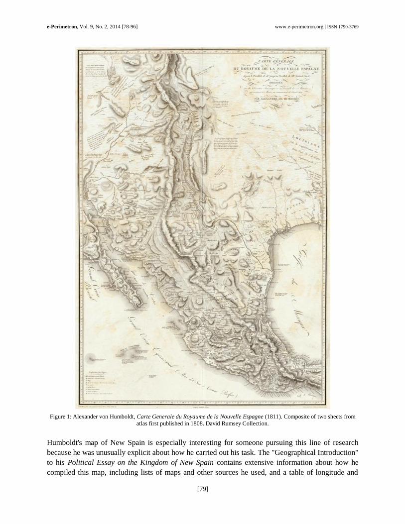
Alexander von Humboldt's overview map of New Spain (Fig. 1), first published in 1808, is widely
recognized as a landmark in the history of cartography.1 It was seen by contemporaries as superseding
all previous maps of Mexico, and it heavily influenced later maps of that country through the first half
of the nineteenth century.
Aside from its intrinsic importance, this map poses significant questions about its construction. Like
most small or medium-scale maps made prior to the middle of the nineteenth century, it was cobbled
together from various sources, including a large number of Spanish or Mexican maps, along with
Humboldt's own surveys and observations in central Mexico. This makes one wonder: How original
was Humboldt's work? What sources did he actually use, and how did he use them? How accurate
was his work in comparison with that of his predecessors and successors?
* Map Librarian (Emeritus), Stony Brook University (State University of New York) [[email protected]]
1 Alexander von Humboldt, Carte générale du royaume de la Nouvelle Espagne depuis le parallele de 16° jusqu'au
parallele de 38° (latitude nord). dressée sur des observations astronomiques et sur l'ensemble des materiaux qui
existoient a Mexico, au commencement de l'annee 1804. The earliest printed edition of this map appeared in 1808,
and was published as two sheets of his Atlas géographique et physique du royaume de la Nouvelle-Espagne, fondé
sur des observations astronomiques, des mesures trigonométriques et des nivellemens barométriques (Paris: F.
Schoell and Tubingen: J.G. Cotta). The 1808 edition is available online from the University Complutense (Madrid)
at http://dioscorides.ucm.es/proyecto_digitalizacion/index.php?doc=b23177585&y=2010&p=1. An 1811 printing of
the atlas by Schoell, which is sometimes cited as the first edition of this work, is available in its entirety from the
David Rumsey Collection. To confuse matters further, the map is dated 1809 in both the 1808 and the 1811 editions
of the atlas. Used for this project is a composite of the two sheets from the 1811 printing made available on the Web
by David Rumsey at http://www.davidrumsey.com/luna/servlet/s/p616lm.
which it was based was largely compiled during his visit to Mexico in 1803 and 1804.6 Only a few
changes appear to have been made later based on information that Humboldt received after 1804.
Humboldt maintained that all previously published maps of New Spain were deficient and
unreliable.7 There is considerable substance to this criticism, for much of Mexico was poorly
explored, and mapmakers based in Europe, or even in Mexico City, were not in a good position to
collect and evaluate what evidence existed. They often uncritically copied from earlier maps, thereby
perpetuating for centuries egregious errors, such as the notion that California is an island. According
to Humboldt, there had been little improvement over the years, and he had especially unkind words
for the two recent maps that came closest to rivaling his own-one by José Antonio Alzate y Ramírez
(1737-99), and the other by Aaron Arrowsmith (1750-1823). It is worth examining these two maps to
see in what ways they resembled and differed from Humboldt's production.
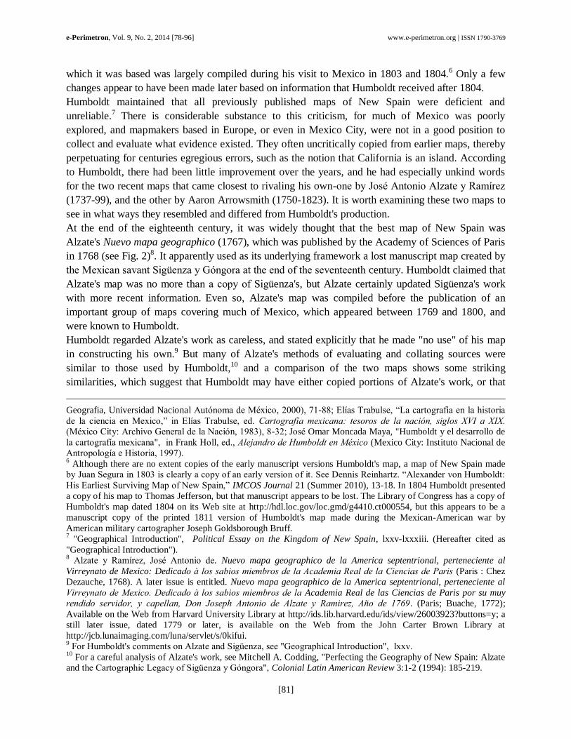
At the end of the eighteenth century, it was widely thought that the best map of New Spain was
Alzate's Nuevo mapa geographico (1767), which was published by the Academy of Sciences of Paris
in 1768 (see Fig. 2)8. It apparently used as its underlying framework a lost manuscript map created by
the e ican savant Si üenza y n ora at the end of the seventeenth century. Humboldt claimed that
Alzate's map was no more than a copy of Si üenza's, but Alzate certainly updated Sigüenza's work
with more recent information. Even so, Alzate's map was compiled before the publication of an
important group of maps covering much of Mexico, which appeared between 1769 and 1800, and
were known to Humboldt.
Humboldt regarded Alzate's work as careless, and stated explicitly that he made "no use" of his map
in constructing his own.9 But many of Alzate's methods of evaluating and collating sources were
similar to those used by Humboldt,10 and a comparison of the two maps shows some striking
similarities, which suggest that Humboldt may have either copied portions of Alzate's work, or that
Geografia, Universidad Nacional Aut noma de é ico, 2000 , 7 - ; lías Trabulse, “ a carto rafia en la historia
de la ciencia en e ico,” in lías Trabulse, ed. Cartografía mexi ana: tesoros de la na ión, siglos XVI a XIX.
é ico City Archivo eneral de la Naci n, 3 , -32; José Omar Moncada Maya, "Humboldt y el desarrollo de
la carto rafía me icana", in rank Holl, ed., Alejandro de Humboldt en éxi o (Mexico City: Instituto Nacional de
Antropolo ía e Historia, 7 . 6 Although there are no extent copies of the early manuscript versions Humboldt's map, a map of New Spain made
by Juan Se ura in 03 is clearly a copy of an early version of it. See ennis Reinhartz. “Ale ander von Humboldt
His arliest Survivin ap of New Spain,” IMCOS Journal 21 (Summer 2010), 13-18. In 1804 Humboldt presented
a copy of his map to Thomas Jefferson, but that manuscript appears to be lost. The Library of Congress has a copy of
Humboldt's map dated 1804 on its Web site at http://hdl.loc.gov/loc.gmd/g4410.ct000554, but this appears to be a
manuscript copy of the printed 1811 version of Humboldt's map made during the Mexican-American war by
American military cartographer Joseph Goldsborough Bruff. 7 "Geographical Introduction", Political Essay on the Kingdom of New Spain, lxxv-lxxxiii. (Hereafter cited as
"Geographical Introduction"). 8 Alzate y Ramírez, José Antonio de. Nuevo mapa geographico de la America septentrional, perteneciente al
Virreynato de Mexico: Dedicado los sabios miembros de la A ademia eal de la Cien ias de aris (Paris : Chez
Dezauche, 1768). A later issue is entitled. Nuevo mapa geographico de la America septentrional, perteneciente al
Virreynato de exi o. Dedi ado los sabios miembros de la Academia Real de las Ciencias de Paris por su muy
rendido servidor, y apellan, Don Joseph Antonio de Alzate y amirez, Año de 1 69. (Paris; Buache, 1772);
Available on the Web from Harvard University Library at http://ids.lib.harvard.edu/ids/view/26003923?buttons=y; a
still later issue, dated 1779 or later, is available on the Web from the John Carter Brown Library at
http://jcb.lunaimaging.com/luna/servlet/s/0kifui. 9 or Humboldt's comments on Alzate and Si üenza, see " eo raphical Introduction", l v.
10 For a careful analysis of Alzate's work, see Mitchell A. Codding, "Perfecting the Geography of New Spain: Alzate
and the Carto raphic e acy of Si üenza y n ora", Colonial Latin American Review 3:1-2 (1994): 185-219.
both cartographers relied on the same sources. The similarities and differences between the two maps
will be discussed in the following section.
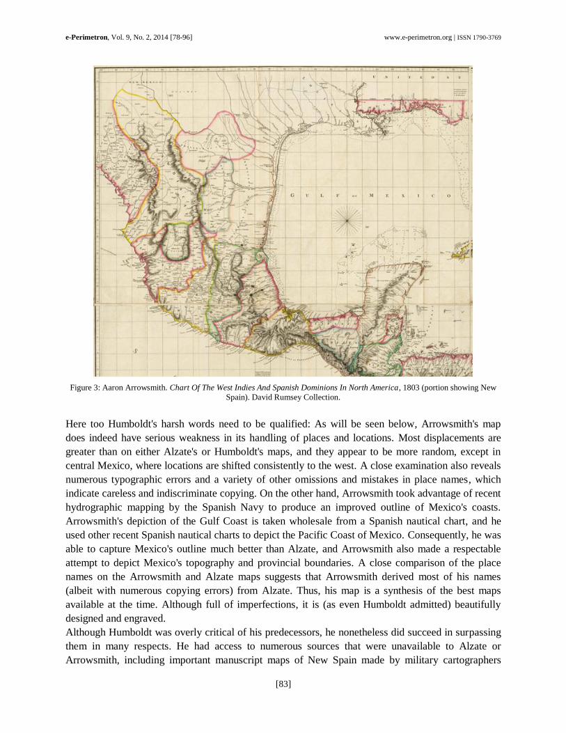
Figure 2: José Antonio de Alzate y Ramírez, Nuevo mapa geographico de la America septentrional, perteneciente al Virreynato de Mexico, 1769. Harvard University Library.
Humboldt was also very critical of all other recent published maps of Mexico, including those of such
highly regarded cartographers as Delisle, Jeffreys, Bonne, and Arrowsmith. Regarding Arrowsmith's
1803 map of Mexico, he remarked: “It appears astonishing that the most recent map which we
possess of that part of New Spain which we are analyzing, and which bears the name of a justly
esteemed author, should be the falsest of all. I speak of the large English map, which has for title,
Chart of the West Indies and Spanish Dominions in North America, by Arrowsmith, published in June
1803" (Fig. 3). He specifically criticized Arrowsmith for his errors in place names and locations:
"From Mexico to Vera Cruz the names appear to be scattered at random", and he added for good
measure that Arrowsmith's mislocation of the Pic d'Orizaba "might prove dangerous to navigators".11
11
"Geographical Introduction", xliv-xlvii. Compare with Aaron Arrowsmith, Chart of the West Indies and Spanish
Dominions In North America (London: Arrowsmith, 1803), http://www.davidrumsey.com/luna/servlet/s/7ib6ip.


![[Alexander Von Humboldt] Letters of Alexander Von Humboldt](https://static.documents.pub/doc/80x56/577c79791a28abe05492c6ea/alexander-von-humboldt-letters-of-alexander-von-humboldt.jpg)