42
Amalfi ESA–SPPA Landsat Add-on User Manual amalfi-esa-sppa-landsat-1.0.10 GAEL-P255-SUM-002-01-04 February 2014 Copyright © GAEL Systems
Amalfi ESA–SPPA Landsat
Add-on User Manual
amalfi-esa-sppa-landsat-1.0.10
GAEL-P255-SUM-002-01-04
February 2014
Copyright © GAEL Systems
2 / 42
Copyright © GAEL Systems – GAEL-P255-SUM-002-01-04, 2014-02-14 This document discloses subject matter in which GAEL Systems has proprietary rights. Recipient of this document shall not duplicate, use or disclose in whole or in part, information disclosed here on except for or on behalf of GAEL Systems to fulfill the purpose for which the document was delivered to him.
Table of Content
Introduction ................................................................................................................................. 3
Anatomy of the Add-on ................................................................................................................ 4
Physical View ...................................................................................................................................... 4
Dependencies - Logical View .............................................................................................................. 4
Amalfi configuration for Landsat USGS products ............................................................................... 5
Landsat DRB Cortex Topic for Landsat USGS products ...................................................................... 6
Classes of Items ............................................................................................................................ 8
Landsat Products Coverage ........................................................................................................... 9
Landsat Quality Control Plans ..................................................................................................... 10
Landsat TM GeoTIFF Products .......................................................................................................... 10
Landsat ETM+ GeoTIFF Products ...................................................................................................... 19
Landsat MSS GeoTIFF Products ........................................................................................................ 28
Appendix – System Requirements ............................................................................................... 38
System Requirements ...................................................................................................................... 38
Software Requirements ................................................................................................................... 38
Acronyms and Abbreviations ...................................................................................................... 39
Glossary of Terms ....................................................................................................................... 40
Bibliography ............................................................................................................................... 41
Document Change Log ................................................................................................................ 42
3 / 42
Copyright © GAEL Systems – GAEL-P255-SUM-002-01-04, 2014-02-14 This document discloses subject matter in which GAEL Systems has proprietary rights. Recipient of this document shall not duplicate, use or disclose in whole or in part, information disclosed here on except for or on behalf of GAEL Systems to fulfill the purpose for which the document was delivered to him.
Introduction
This document describes the Amalfi Add-on named "ESA–SPPA Landsat" dedicated to the quality
control of Landsat TM, ETM+ and MSS products distributed by the European Space Agency (ESA) and
formatted in GeoTIFF respectively according to the USGS Data Format Control Books [LS-DFBC-20],
[LS-DFCB-04] and [LS-DFCB-22]. This documents includes a general description of the add-on
composing files, an overview of the actually controlled files and the complete definitions of the
inspections applied. The document is structured as follow:
Chapter 1 – Introduction The present chapter
Chapter 2 – Anatomy of the Add-on Logical and Physical description of the Add-on files
Chapter 3 – Classes of Items Description of the Ontology supporting the file types
Chapter 4 – Landsat Products Coverage Overview of files actually controlled
Chapter 5 – Landsat Quality Control Plans The Quality Control plans applied for each product type
Appendix – System Requirements Requirements for installing this add-on
Appendix – Acronyms and Abbreviation Those abbreviations used in this document
Appendix – Glossary of Terms Definition of terms used in this document
Appendix – Bibliography Complete description of referenced books or articles
Appendix – Document Change Log This document change log
Note: it is expected that readers of this document have some familiarity with Amalfi general concepts
and potentially with related technologies as DRB API®, XML, XML Schema, XQuery, etc. This
knowledge can be acquired through the Amalfi – Software User Manual [AMALFI-SUM].
4 / 42
Copyright © GAEL Systems – GAEL-P255-SUM-002-01-04, 2014-02-14 This document discloses subject matter in which GAEL Systems has proprietary rights. Recipient of this document shall not duplicate, use or disclose in whole or in part, information disclosed here on except for or on behalf of GAEL Systems to fulfill the purpose for which the document was delivered to him.
Anatomy of the Add-on
Physical View
The add-on is composed of the following files, usually installed under the "addons" sub-directory of
the main installation folder:
├── amalfi-config-landsat-usgs-1.0.10.jar
├── drbx-cortex-topic-landsat-usgs-1.0.9.jar
├── DRBx-impl-image-1-0-beta-5.jar
├── DRBx-impl-netcdf-1-0-rc-6-SNAPSHOT.jar
├── DRBx-impl-text-1-0-beta-1.jar
└── DRBx-impl-tiff-1.1.jar
The entry point of the add-on is the amalfi-config-landsat-usgs-<version>.jar file
described in the section "Amalfi configuration for Landsat products" below.
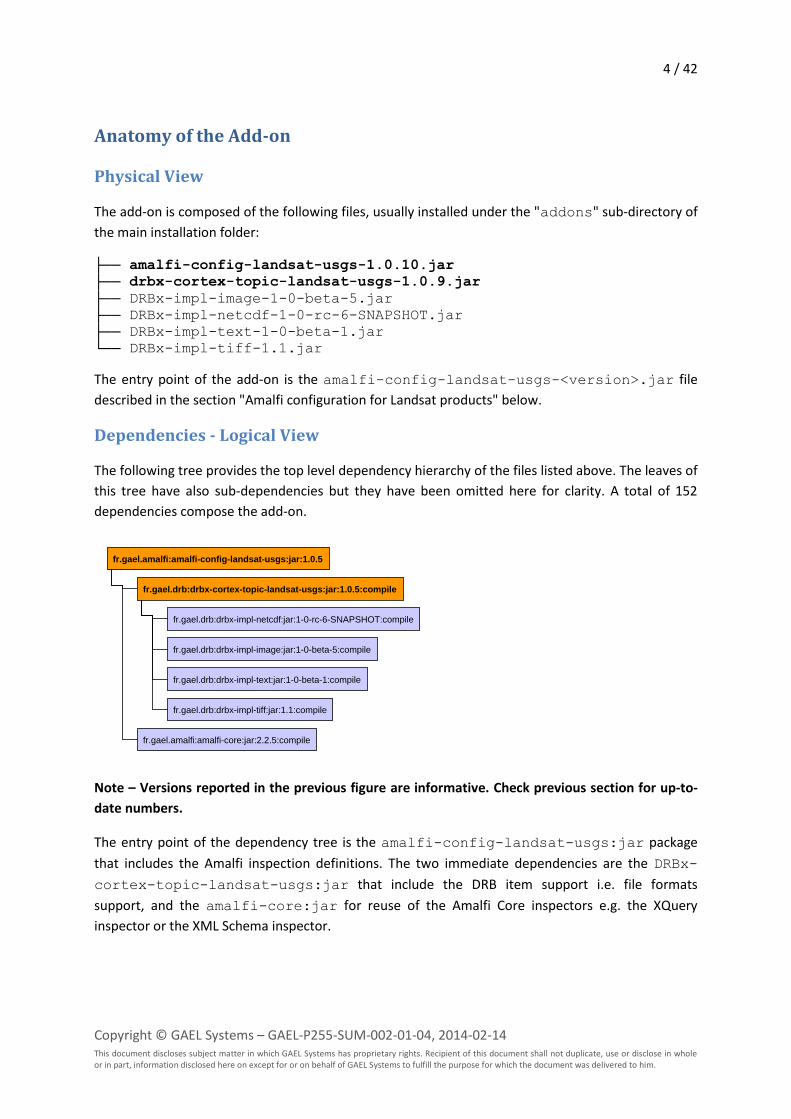
Dependencies - Logical View
The following tree provides the top level dependency hierarchy of the files listed above. The leaves of
this tree have also sub-dependencies but they have been omitted here for clarity. A total of 152
dependencies compose the add-on.
Note – Versions reported in the previous figure are informative. Check previous section for up-to-
date numbers.
The entry point of the dependency tree is the amalfi-config-landsat-usgs:jar package
that includes the Amalfi inspection definitions. The two immediate dependencies are the DRBx-
cortex-topic-landsat-usgs:jar that include the DRB item support i.e. file formats
support, and the amalfi-core:jar for reuse of the Amalfi Core inspectors e.g. the XQuery
inspector or the XML Schema inspector.
fr.gael.amalfi:amalfi-config-landsat-usgs:jar:1.0.5
fr.gael.drb:drbx-cortex-topic-landsat-usgs:jar:1.0.5:compile
fr.gael.drb:drbx-impl-text:jar:1-0-beta-1:compile
fr.gael.drb:drbx-impl-tiff:jar:1.1:compile
fr.gael.drb:drbx-impl-image:jar:1-0-beta-5:compile
fr.gael.drb:drbx-impl-netcdf:jar:1-0-rc-6-SNAPSHOT:compile
fr.gael.amalfi:amalfi-core:jar:2.2.5:compile
5 / 42
Copyright © GAEL Systems – GAEL-P255-SUM-002-01-04, 2014-02-14 This document discloses subject matter in which GAEL Systems has proprietary rights. Recipient of this document shall not duplicate, use or disclose in whole or in part, information disclosed here on except for or on behalf of GAEL Systems to fulfill the purpose for which the document was delivered to him.
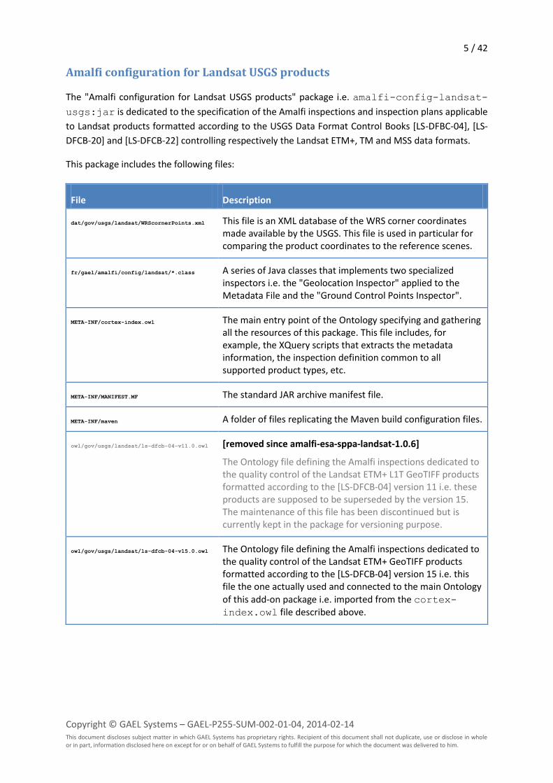
Amalfi configuration for Landsat USGS products
The "Amalfi configuration for Landsat USGS products" package i.e. amalfi-config-landsat-
usgs:jar is dedicated to the specification of the Amalfi inspections and inspection plans applicable
to Landsat products formatted according to the USGS Data Format Control Books [LS-DFBC-04], [LS-
DFCB-20] and [LS-DFCB-22] controlling respectively the Landsat ETM+, TM and MSS data formats.
This package includes the following files:
File Description
dat/gov/usgs/landsat/WRScornerPoints.xml This file is an XML database of the WRS corner coordinates made available by the USGS. This file is used in particular for comparing the product coordinates to the reference scenes.
fr/gael/amalfi/config/landsat/*.class A series of Java classes that implements two specialized inspectors i.e. the "Geolocation Inspector" applied to the Metadata File and the "Ground Control Points Inspector".
META-INF/cortex-index.owl The main entry point of the Ontology specifying and gathering all the resources of this package. This file includes, for example, the XQuery scripts that extracts the metadata information, the inspection definition common to all supported product types, etc.
META-INF/MANIFEST.MF The standard JAR archive manifest file.
META-INF/maven A folder of files replicating the Maven build configuration files.
owl/gov/usgs/landsat/ls-dfcb-04-v11.0.owl [removed since amalfi-esa-sppa-landsat-1.0.6]
The Ontology file defining the Amalfi inspections dedicated to the quality control of the Landsat ETM+ L1T GeoTIFF products formatted according to the [LS-DFCB-04] version 11 i.e. these products are supposed to be superseded by the version 15. The maintenance of this file has been discontinued but is currently kept in the package for versioning purpose.
owl/gov/usgs/landsat/ls-dfcb-04-v15.0.owl The Ontology file defining the Amalfi inspections dedicated to the quality control of the Landsat ETM+ GeoTIFF products formatted according to the [LS-DFCB-04] version 15 i.e. this file the one actually used and connected to the main Ontology of this add-on package i.e. imported from the cortex-index.owl file described above.
6 / 42
Copyright © GAEL Systems – GAEL-P255-SUM-002-01-04, 2014-02-14 This document discloses subject matter in which GAEL Systems has proprietary rights. Recipient of this document shall not duplicate, use or disclose in whole or in part, information disclosed here on except for or on behalf of GAEL Systems to fulfill the purpose for which the document was delivered to him.
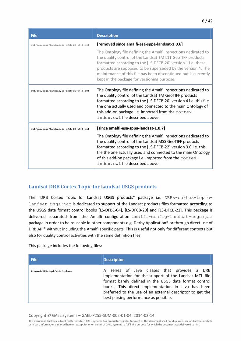
File Description
owl/gov/usgs/landsat/ls-dfcb-20-v1.0.owl [removed since amalfi-esa-sppa-landsat-1.0.6]
The Ontology file defining the Amalfi inspections dedicated to the quality control of the Landsat TM L1T GeoTIFF products formatted according to the [LS-DFCB-20] version 1 i.e. these products are supposed to be superseded by the version 4. The maintenance of this file has been discontinued but is currently kept in the package for versioning purpose.
owl/gov/usgs/landsat/ls-dfcb-20-v4.0.owl The Ontology file defining the Amalfi inspections dedicated to the quality control of the Landsat TM GeoTIFF products formatted according to the [LS-DFCB-20] version 4 i.e. this file the one actually used and connected to the main Ontology of this add-on package i.e. imported from the cortex-index.owl file described above.
owl/gov/usgs/landsat/ls-dfcb-22-v3.0.owl [since amalfi-esa-sppa-landsat-1.0.7]
The Ontology file defining the Amalfi inspections dedicated to the quality control of the Landsat MSS GeoTIFF products formatted according to the [LS-DFCB-22] version 3.0 i.e. this file the one actually used and connected to the main Ontology of this add-on package i.e. imported from the cortex-index.owl file described above.
Landsat DRB Cortex Topic for Landsat USGS products
The "DRB Cortex Topic for Landsat USGS products" package i.e. DRBx-cortex-topic-
landsat-usgs:jar is dedicated to support of the Landsat products files formatted according to
the USGS data format control books [LS-DFBC-04], [LS-DFCB-20] and [LS-DFCB-22]. This package is
delivered separated from the Amalfi configuration amalfi-config-landsat-usgs:jar
package in order to be reusable in other components e.g. Derby Application® or through direct use of
DRB API® without including the Amalfi specific parts. This is useful not only for different contexts but
also for quality control activities with the same definition files.
This package includes the following files:
File Description
fr/gael/DRB/impl/mtl/*.class A series of Java classes that provides a DRB implementation for the support of the Landsat MTL file format barely defined in the USGS data format control books. This direct implementation in Java has been preferred to the use of an external descriptor to get the best parsing performance as possible.
7 / 42
Copyright © GAEL Systems – GAEL-P255-SUM-002-01-04, 2014-02-14 This document discloses subject matter in which GAEL Systems has proprietary rights. Recipient of this document shall not duplicate, use or disclose in whole or in part, information disclosed here on except for or on behalf of GAEL Systems to fulfill the purpose for which the document was delivered to him.
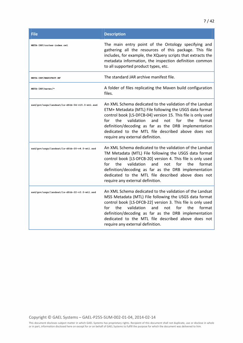
File Description
META-INF/cortex-index.owl The main entry point of the Ontology specifying and gathering all the resources of this package. This file includes, for example, the XQuery scripts that extracts the metadata information, the inspection definition common to all supported product types, etc.
META-INF/MANIFEST.MF The standard JAR archive manifest file.
META-INF/maven/* A folder of files replicating the Maven build configuration files.
xsd/gov/usgs/landsat/ls-dfcb-04-v15.0-mtl.xsd An XML Schema dedicated to the validation of the Landsat ETM+ Metadata (MTL) File following the USGS data format control book [LS-DFCB-04] version 15. This file is only used for the validation and not for the format definition/decoding as far as the DRB implementation dedicated to the MTL file described above does not require any external definition.
xsd/gov/usgs/landsat/ls-dfcb-20-v4.0-mtl.xsd An XML Schema dedicated to the validation of the Landsat TM Metadata (MTL) File following the USGS data format control book [LS-DFCB-20] version 4. This file is only used for the validation and not for the format definition/decoding as far as the DRB implementation dedicated to the MTL file described above does not require any external definition.
xsd/gov/usgs/landsat/ls-dfcb-22-v3.0-mtl.xsd An XML Schema dedicated to the validation of the Landsat MSS Metadata (MTL) File following the USGS data format control book [LS-DFCB-22] version 3. This file is only used for the validation and not for the format definition/decoding as far as the DRB implementation dedicated to the MTL file described above does not require any external definition.
8 / 42
Copyright © GAEL Systems – GAEL-P255-SUM-002-01-04, 2014-02-14 This document discloses subject matter in which GAEL Systems has proprietary rights. Recipient of this document shall not duplicate, use or disclose in whole or in part, information disclosed here on except for or on behalf of GAEL Systems to fulfill the purpose for which the document was delivered to him.
Classes of Items
This chapter dedicated to the description of the DRB Items e.g. files, product types, etc. is to be
developed in a successive version of this document. The section should also cover the properties
associated to each item and for example, the signature of the items, the image descriptors, the
hierarchy of classes, the item identification methods, image rending operators, etc.
9 / 42
Copyright © GAEL Systems – GAEL-P255-SUM-002-01-04, 2014-02-14 This document discloses subject matter in which GAEL Systems has proprietary rights. Recipient of this document shall not duplicate, use or disclose in whole or in part, information disclosed here on except for or on behalf of GAEL Systems to fulfill the purpose for which the document was delivered to him.
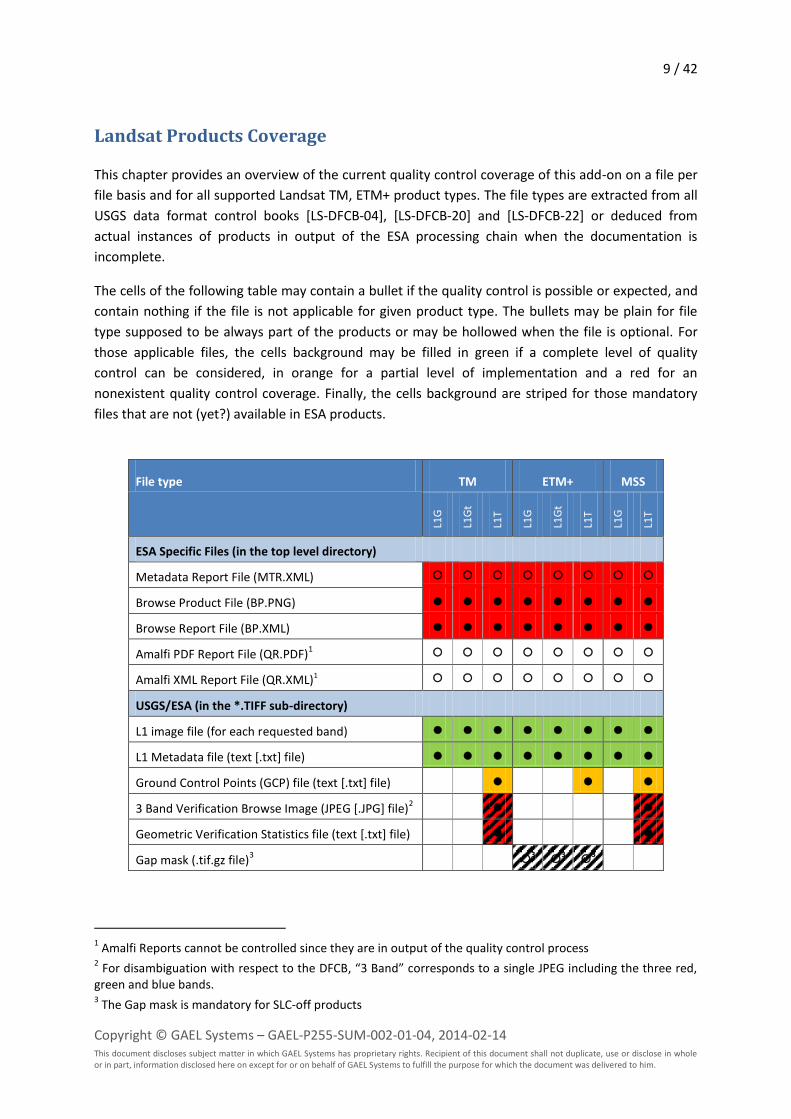
Landsat Products Coverage
This chapter provides an overview of the current quality control coverage of this add-on on a file per
file basis and for all supported Landsat TM, ETM+ product types. The file types are extracted from all
USGS data format control books [LS-DFCB-04], [LS-DFCB-20] and [LS-DFCB-22] or deduced from
actual instances of products in output of the ESA processing chain when the documentation is
incomplete.
The cells of the following table may contain a bullet if the quality control is possible or expected, and
contain nothing if the file is not applicable for given product type. The bullets may be plain for file
type supposed to be always part of the products or may be hollowed when the file is optional. For
those applicable files, the cells background may be filled in green if a complete level of quality
control can be considered, in orange for a partial level of implementation and a red for an
nonexistent quality control coverage. Finally, the cells background are striped for those mandatory
files that are not (yet?) available in ESA products.
File type TM ETM+ MSS
L1G
L1G
t
L1T
L1G
L1G
t
L1T
L1G
L1T
ESA Specific Files (in the top level directory)
Metadata Report File (MTR.XML)
Browse Product File (BP.PNG)
Browse Report File (BP.XML)
Amalfi PDF Report File (QR.PDF)1
Amalfi XML Report File (QR.XML)1
USGS/ESA (in the *.TIFF sub-directory)
L1 image file (for each requested band)
L1 Metadata file (text [.txt] file)
Ground Control Points (GCP) file (text [.txt] file)
3 Band Verification Browse Image (JPEG [.JPG] file)2
Geometric Verification Statistics file (text [.txt] file)
Gap mask (.tif.gz file)3
3
3
3
1 Amalfi Reports cannot be controlled since they are in output of the quality control process
2 For disambiguation with respect to the DFCB, “3 Band” corresponds to a single JPEG including the three red,
green and blue bands. 3 The Gap mask is mandatory for SLC-off products
10 / 42
Copyright © GAEL Systems – GAEL-P255-SUM-002-01-04, 2014-02-14 This document discloses subject matter in which GAEL Systems has proprietary rights. Recipient of this document shall not duplicate, use or disclose in whole or in part, information disclosed here on except for or on behalf of GAEL Systems to fulfill the purpose for which the document was delivered to him.
Landsat Quality Control Plans
The following sections describe the inspection plans applicable for:
Landsat TM GeoTIFF Products (p. 10)
Landsat ETM+ GeoTIFF Products (p. 19) and
Landsat MSS GeoTIFF Products (p. 28)
Landsat TM GeoTIFF Products
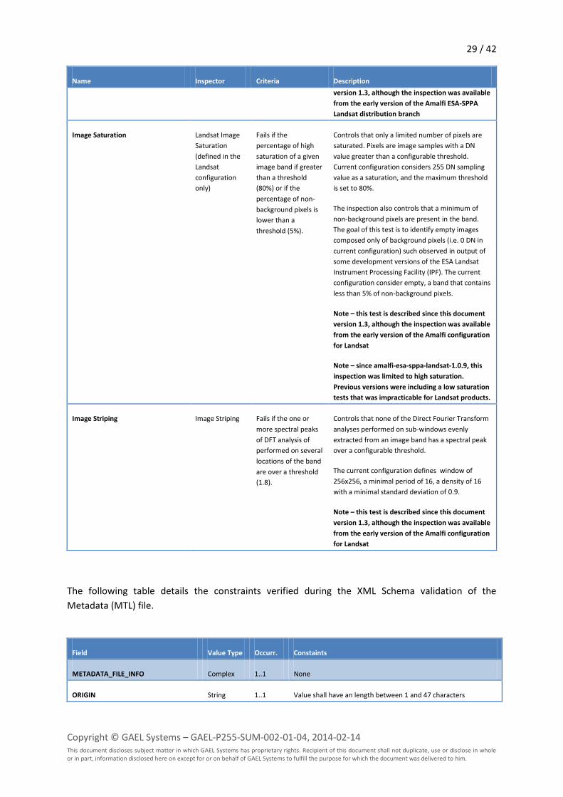
The following inspection plan is applied to any Landsat TM L1T GeoTIFF Product:
Name Inspector Criteria Description
TM L1 Metadata (MTL) Inspection
Plan
Plan Fails upon any sub-
inspection failure
The top level inspection plan for TM L1 Metadata
(MTL) file
TM File Name Pattern XQuery Fails if the pattern
does not match the
specifications
Controls that the actual metadata file name
conforms to the one specified in the [LS-DFCB-20]
XML Schema Validation XML Schema Fails upon any
validation error
Applies the Metadata file XML Schema included in
the DRB Cortex Topic and applicable to the TM
Metadata file i.e. the ls-dfcb-20-v4.0-mtl.xsd file
included in the drbx-cortex-topic-landsat-usgs:jar
package (introduced in earlier chapters). The
quality controlled applied to each element is
defined in the table following the present one.
Creation Time XQuery Fails if the data
structure does not
conform to ISO 8601
standard
Extracts and verifies that the
METADATA_FILE_INFO/FILE_DATE field conforms
to the ISO 8610 standard
Sensor Mode Inspection XQuery Fails if the sensor
mode does not
match the allowed
period for the
acquiring platform
Extracts and verifies that the
PRODUCT_METADATA /SENSOR_MODE field is
correct according to the
PRODUCT_METADATA/DATE_ACQUIRED. For
Landsat 5 TM, the sensor mode is supposed to be
SAM up to 2002-03-01T00:00:00 and BUMPER
after this date. For Landsat 4 the mode shall
always be SAM.
Acquisition Date Inspection XQuery Fails if the acquisition
date is outside the
actual operational
period of the
acquiring platform
Extracts and verifies that the
PRODUCT_METADATA /DATE_ACQUIRED field is
correct according to the actual operational period
of acquiring platform i.e.
PRODUCT_METADATA/SPACECRAFT_ID field.
For Landsat 4, the acquisition date shall be after
1982-07-16T00:00:00 and before 1993-12-
14T00:00:00.
For Landsat 5, the acquisition date shall be after
11 / 42
Copyright © GAEL Systems – GAEL-P255-SUM-002-01-04, 2014-02-14 This document discloses subject matter in which GAEL Systems has proprietary rights. Recipient of this document shall not duplicate, use or disclose in whole or in part, information disclosed here on except for or on behalf of GAEL Systems to fulfill the purpose for which the document was delivered to him.
Name Inspector Criteria Description
1984-03-01T00:00:00 and before 2012-05-
08T00:00:00.
Geolocation Inspection MTLGeolocation Fails if the
overlapping ratio is
over 75%
(configurable)
Reads the Landsat World Reference System (WRS)
path/row and geographic coordinates from the
Metadata file, validates all of them and check their
consistency with respect to a reference WRS
database of corner points made available by USGS.
The consistency is estimated by the overlapping
percentage between the product footprint and the
one of the expected by the reference WRS. Any
distance or surface are computed over the WGS84
ellipsoid. The report includes a map of the product
image and WRS geographical extents for a better
comprehension of the adherence with the
reference positions.
L1 GCP Inspection Plan Plan Fails upon any sub-
inspection failure
The top level inspection plan for TM L1 Ground
Control Point (GCP) file
GCP File Name Pattern XQuery Fails if the pattern
does not match the
specifications
Controls that the actual GCP file name conforms to
the one specified in the [LS-DFCB-20]
Ground Control Points GCP Fails if any residual
exceeds 35 m or if
less than 15 ground
control points have
been found.
Extracts all GCPs and verifies that more than 14
have been found and that any of the along and
across scan residuals are not greater than 35
metres. The report includes a map of the GCPs
over the product image geographical extents for a
better comprehension of the GCP distribution. The
GCPs are plotted in green if they have correct
residuals and in red otherwise.
L1 Image Inspection Plan Plan Fails upon any sub-
inspection failure
The top level inspection plan for TM L1 Ground
Control Point (GCP) file
File Name Pattern Inspection XQuery Fails if the pattern
does not match the
specifications
Controls that the actual BAND file name conforms
to the one specified in the [LS-DFCB-20].
Note – this test is described since this document
version 1.3, although the inspection was available
from the early version of the Amalfi ESA-SPPA
Landsat distribution branch
Image Saturation Landsat Image
Saturation
(defined in the
Landsat
configuration
only)
Fails if the
percentage of high
saturation of a given
image band if greater
than a threshold
(80%) or if the
percentage of non-
background pixels is
lower than a
threshold (5%).
Controls that only a limited number of pixels are
saturated. Pixels are image samples with a DN
value greater than a configurable threshold.
Current configuration considers 255 DN sampling
value as a saturation, and the maximum threshold
is set to 80%.
The inspection also controls that a minimum of
non-background pixels are present in the band.
The goal of this test is to identify empty images
composed only of background pixels (i.e. 0 DN in
current configuration) such observed in output of
some development versions of the ESA Landsat
Instrument Processing Facility (IPF). The current
configuration consider empty, a band that contains

12 / 42
Copyright © GAEL Systems – GAEL-P255-SUM-002-01-04, 2014-02-14 This document discloses subject matter in which GAEL Systems has proprietary rights. Recipient of this document shall not duplicate, use or disclose in whole or in part, information disclosed here on except for or on behalf of GAEL Systems to fulfill the purpose for which the document was delivered to him.
Name Inspector Criteria Description
less than 5% of non-background pixels.
Note – this test is described since this document
version 1.3, although the inspection was available
from the early version of the Amalfi configuration
for Landsat
Note – since amalfi-esa-sppa-landsat-1.0.9, this
inspection was limited to high saturation.
Previous versions were including a low saturation
tests that was impracticable for Landsat products.
Image Striping Image Striping Fails if the one or
more spectral peaks
of DFT analysis of
performed on several
locations of the band
are over a threshold
(1.8).
Controls that none of the Direct Fourier Transform
analyses performed on sub-windows evenly
extracted from an image band has a spectral peak
over a configurable threshold.
The current configuration defines window of
256x256, a minimal period of 16, a density of 16
with a minimal standard deviation of 0.9.
Note – this test is described since this document
version 1.3, although the inspection was available
from the early version of the Amalfi configuration
for Landsat
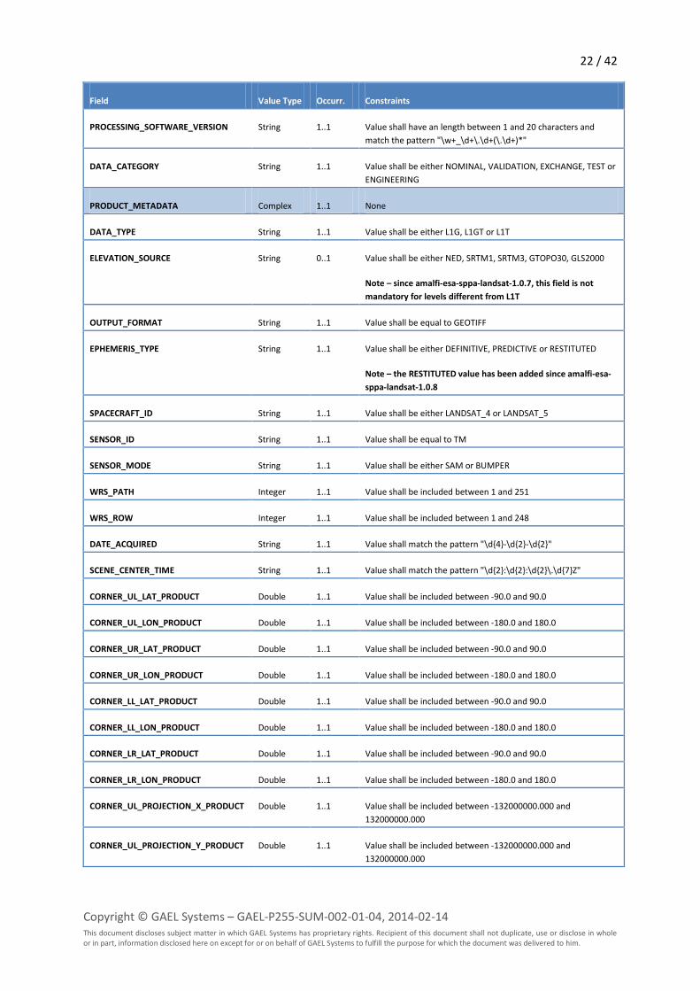
The following table details the constraints verified during the XML Schema validation of the
Metadata (MTL) file.
Field Value Type Occurr. Constraints
METADATA_FILE_INFO Complex 1..1 None
ORIGIN String 1..1 Value shall have an length between 1 and 47 characters
REQUEST_ID String 1..1 Value shall have an length between 1 and 20 characters
LANDSAT_SCENE_ID String 1..1 Value shall match the pattern "LT[45]\d{3}\d{3}\d{4}\d{3}...\d{2}"
FILE_DATE dateTime 1..1 ISO 8610 formatted
STATION_ID String 1..1 Value shall have a length equal to 3
PROCESSING_SOFTWARE_VERSION String 1..1 Value shall have an length between 1 and 20 characters and
match the pattern "\w+_\d+\.\d+(\.\d+)*"
DATA_CATEGORY String 1..1 Value shall be either NOMINAL, VALIDATION, EXCHANGE, TEST or
ENGINEERING
PRODUCT_METADATA Complex 1..1 None
DATA_TYPE String 1..1 Value shall be either L1G, L1GT or L1T
DATA_TYPE_L0R String 0..1 Value shall be either TMA_L0RP or TMR_L0RP
13 / 42
Copyright © GAEL Systems – GAEL-P255-SUM-002-01-04, 2014-02-14 This document discloses subject matter in which GAEL Systems has proprietary rights. Recipient of this document shall not duplicate, use or disclose in whole or in part, information disclosed here on except for or on behalf of GAEL Systems to fulfill the purpose for which the document was delivered to him.
Field Value Type Occurr. Constraints
ELEVATION_SOURCE String 0..1 Value shall be either NED, SRTM1, SRTM3, GTOPO30, GLS2000
Note – since amalfi-esa-sppa-landsat-1.0.7, this field is not
mandatory for levels different from L1T
OUTPUT_FORMAT String 1..1 Value shall be equal to GEOTIFF
EPHEMERIS_TYPE String 1..1 Value shall be either DEFINITIVE, PREDICTIVE or RESTITUTED
Note – the RESTITUTED value has been added since amalfi-esa-
sppa-landsat-1.0.8
SPACECRAFT_ID String 1..1 Value shall be either LANDSAT_4 or LANDSAT_5
SENSOR_ID String 1..1 Value shall be equal to TM
SENSOR_MODE String 1..1 Value shall be either SAM or BUMPER
WRS_PATH Integer 1..1 Value shall be included between 1 and 251
WRS_ROW Integer 1..1 Value shall be included between 1 and 248
DATE_ACQUIRED String 1..1 Value shall match the pattern "\d{4}-\d{2}-\d{2}"
SCENE_CENTER_TIME String 1..1 Value shall match the pattern "\d{2}:\d{2}:\d{2}\.\d{7}Z"
CORNER_UL_LAT_PRODUCT Double 1..1 Value shall be included between -90.0 and 90.0
CORNER_UL_LON_PRODUCT Double 1..1 Value shall be included between -180.0 and 180.0
CORNER_UR_LAT_PRODUCT Double 1..1 Value shall be included between -90.0 and 90.0
CORNER_UR_LON_PRODUCT Double 1..1 Value shall be included between -180.0 and 180.0
CORNER_LL_LAT_PRODUCT Double 1..1 Value shall be included between -90.0 and 90.0
CORNER_LL_LON_PRODUCT Double 1..1 Value shall be included between -180.0 and 180.0
CORNER_LR_LAT_PRODUCT Double 1..1 Value shall be included between -90.0 and 90.0
CORNER_LR_LON_PRODUCT Double 1..1 Value shall be included between -180.0 and 180.0
CORNER_UL_PROJECTION_X_PRODUCT Double 1..1 Value shall be included between -132000000.000 and
132000000.000
CORNER_UL_PROJECTION_Y_PRODUCT Double 1..1 Value shall be included between -132000000.000 and
132000000.000
CORNER_UR_PROJECTION_X_PRODUCT Double 1..1 Value shall be included between -132000000.000 and
132000000.000
CORNER_UR_PROJECTION_Y_PRODUCT Double 1..1 Value shall be included between -132000000.000 and
132000000.000
CORNER_LR_PROJECTION_X_PRODUCT Double 1..1 Value shall be included between -132000000.000 and
132000000.000
CORNER_LR_PROJECTION_Y_PRODUCT Double 1..1 Value shall be included between -132000000.000 and
132000000.000
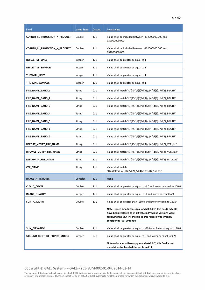
14 / 42
Copyright © GAEL Systems – GAEL-P255-SUM-002-01-04, 2014-02-14 This document discloses subject matter in which GAEL Systems has proprietary rights. Recipient of this document shall not duplicate, use or disclose in whole or in part, information disclosed here on except for or on behalf of GAEL Systems to fulfill the purpose for which the document was delivered to him.
Field Value Type Occurr. Constraints
CORNER_LL_PROJECTION_X_PRODUCT Double 1..1 Value shall be included between -132000000.000 and
132000000.000
CORNER_LL_PROJECTION_Y_PRODUCT Double 1..1 Value shall be included between -132000000.000 and
132000000.000
REFLECTIVE_LINES Integer 1..1 Value shall be greater or equal to 1
REFLECTIVE_SAMPLES Integer 1..1 Value shall be greater or equal to 1
THERMAL_LINES Integer 1..1 Value shall be greater or equal to 1
THERMAL_SAMPLES Integer 1..1 Value shall be greater or equal to 1
FILE_NAME_BAND_1 String 0..1 Value shall match "LT[45]\d{3}\d{3}\d{4}\d{3}...\d{2}_B1\.TIF"
FILE_NAME_BAND_2 String 0..1 Value shall match "LT[45]\d{3}\d{3}\d{4}\d{3}...\d{2}_B2\.TIF"
FILE_NAME_BAND_3 String 0..1 Value shall match "LT[45]\d{3}\d{3}\d{4}\d{3}...\d{2}_B3\.TIF"
FILE_NAME_BAND_4 String 0..1 Value shall match "LT[45]\d{3}\d{3}\d{4}\d{3}...\d{2}_B4\.TIF"
FILE_NAME_BAND_5 String 0..1 Value shall match "LT[45]\d{3}\d{3}\d{4}\d{3}...\d{2}_B5\.TIF"
FILE_NAME_BAND_6 String 0..1 Value shall match "LT[45]\d{3}\d{3}\d{4}\d{3}...\d{2}_B6\.TIF"
FILE_NAME_BAND_7 String 0..1 Value shall match "LT[45]\d{3}\d{3}\d{4}\d{3}...\d{2}_B7\.TIF"
REPORT_VERIFY_FILE_NAME String 0..1 Value shall match "LT[45]\d{3}\d{3}\d{4}\d{3}...\d{2}_VER\.txt"
BROWSE_VERIFY_FILE_NAME String 0..1 Value shall match "LT[45]\d{3}\d{3}\d{4}\d{3}...\d{2}_VER\.jpg"
METADATA_FILE_NAME String 1..1 Value shall match "LT[45]\d{3}\d{3}\d{4}\d{3}...\d{2}_MTL\.txt"
CPF_NAME String 1..1 Value shall match
"L[45]CPF\d{4}\d{2}\d{2}_\d{4}\d{2}\d{2}\.\d{2}"
IMAGE_ATTRIBUTES Complex 1..1 None
CLOUD_COVER Double 1..1 Value shall be greater or equal to -1.0 and lower or equal to 100.0
IMAGE_QUALITY Integer 1..1 Value shall be greater or equal to -1 and lower or equal to 9
SUN_AZIMUTH Double 1..1 Value shall be greater than -180.0 and lower or equal to 180.0
Note – since amalfi-esa-sppa-landsat-1.0.7, this fields extents
have been restored to DFCB values. Previous versions were
following the ESA IPF that up to this release was wrongly
considering -90, 90 range.
SUN_ELEVATION Double 1..1 Value shall be greater or equal to -90.0 and lower or equal to 90.0
GROUND_CONTROL_POINTS_MODEL Integer 0..1 Value shall be greater or equal to 0 and lower or equal to 999
Note – since amalfi-esa-sppa-landsat-1.0.7, this field is not
mandatory for levels different from L1T
15 / 42
Copyright © GAEL Systems – GAEL-P255-SUM-002-01-04, 2014-02-14 This document discloses subject matter in which GAEL Systems has proprietary rights. Recipient of this document shall not duplicate, use or disclose in whole or in part, information disclosed here on except for or on behalf of GAEL Systems to fulfill the purpose for which the document was delivered to him.
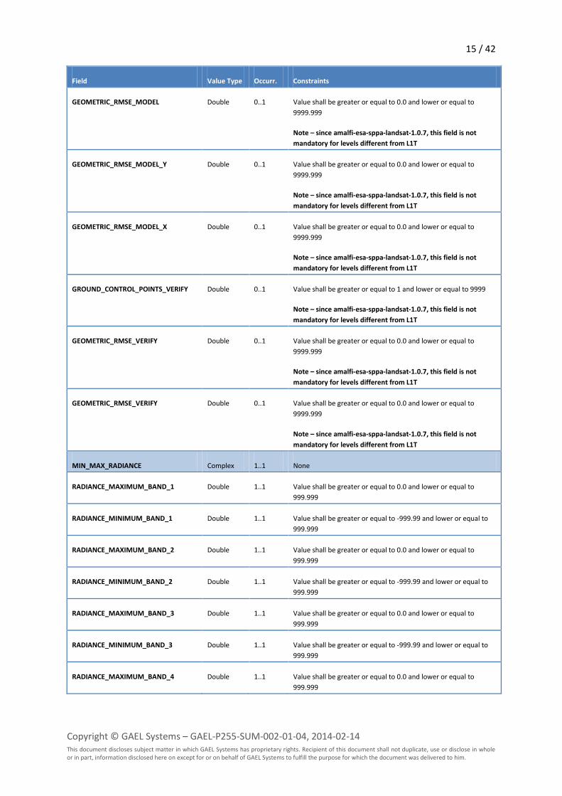
Field Value Type Occurr. Constraints
GEOMETRIC_RMSE_MODEL Double 0..1 Value shall be greater or equal to 0.0 and lower or equal to
9999.999
Note – since amalfi-esa-sppa-landsat-1.0.7, this field is not
mandatory for levels different from L1T
GEOMETRIC_RMSE_MODEL_Y Double 0..1 Value shall be greater or equal to 0.0 and lower or equal to
9999.999
Note – since amalfi-esa-sppa-landsat-1.0.7, this field is not
mandatory for levels different from L1T
GEOMETRIC_RMSE_MODEL_X Double 0..1 Value shall be greater or equal to 0.0 and lower or equal to
9999.999
Note – since amalfi-esa-sppa-landsat-1.0.7, this field is not
mandatory for levels different from L1T
GROUND_CONTROL_POINTS_VERIFY Double 0..1 Value shall be greater or equal to 1 and lower or equal to 9999
Note – since amalfi-esa-sppa-landsat-1.0.7, this field is not
mandatory for levels different from L1T
GEOMETRIC_RMSE_VERIFY Double 0..1 Value shall be greater or equal to 0.0 and lower or equal to
9999.999
Note – since amalfi-esa-sppa-landsat-1.0.7, this field is not
mandatory for levels different from L1T
GEOMETRIC_RMSE_VERIFY Double 0..1 Value shall be greater or equal to 0.0 and lower or equal to
9999.999
Note – since amalfi-esa-sppa-landsat-1.0.7, this field is not
mandatory for levels different from L1T
MIN_MAX_RADIANCE Complex 1..1 None
RADIANCE_MAXIMUM_BAND_1 Double 1..1 Value shall be greater or equal to 0.0 and lower or equal to
999.999
RADIANCE_MINIMUM_BAND_1 Double 1..1 Value shall be greater or equal to -999.99 and lower or equal to
999.999
RADIANCE_MAXIMUM_BAND_2 Double 1..1 Value shall be greater or equal to 0.0 and lower or equal to
999.999
RADIANCE_MINIMUM_BAND_2 Double 1..1 Value shall be greater or equal to -999.99 and lower or equal to
999.999
RADIANCE_MAXIMUM_BAND_3 Double 1..1 Value shall be greater or equal to 0.0 and lower or equal to
999.999
RADIANCE_MINIMUM_BAND_3 Double 1..1 Value shall be greater or equal to -999.99 and lower or equal to
999.999
RADIANCE_MAXIMUM_BAND_4 Double 1..1 Value shall be greater or equal to 0.0 and lower or equal to
999.999
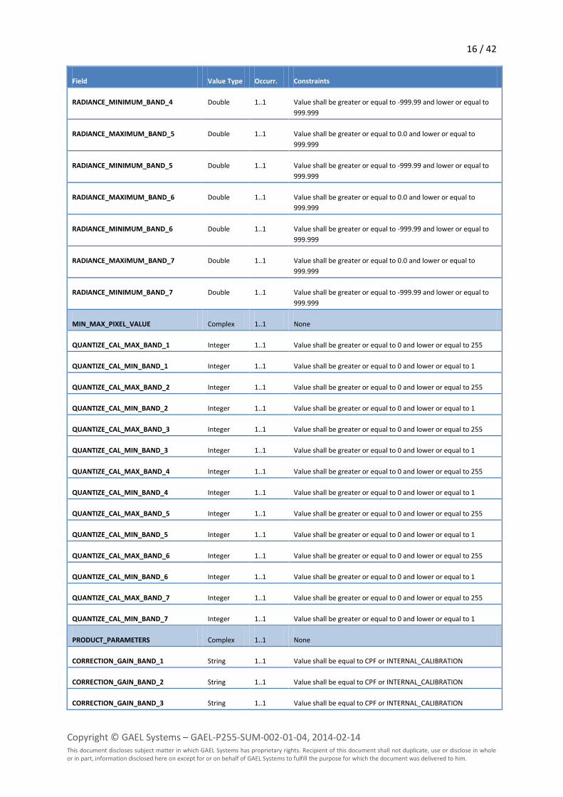
16 / 42
Copyright © GAEL Systems – GAEL-P255-SUM-002-01-04, 2014-02-14 This document discloses subject matter in which GAEL Systems has proprietary rights. Recipient of this document shall not duplicate, use or disclose in whole or in part, information disclosed here on except for or on behalf of GAEL Systems to fulfill the purpose for which the document was delivered to him.
Field Value Type Occurr. Constraints
RADIANCE_MINIMUM_BAND_4 Double 1..1 Value shall be greater or equal to -999.99 and lower or equal to
999.999
RADIANCE_MAXIMUM_BAND_5 Double 1..1 Value shall be greater or equal to 0.0 and lower or equal to
999.999
RADIANCE_MINIMUM_BAND_5 Double 1..1 Value shall be greater or equal to -999.99 and lower or equal to
999.999
RADIANCE_MAXIMUM_BAND_6 Double 1..1 Value shall be greater or equal to 0.0 and lower or equal to
999.999
RADIANCE_MINIMUM_BAND_6 Double 1..1 Value shall be greater or equal to -999.99 and lower or equal to
999.999
RADIANCE_MAXIMUM_BAND_7 Double 1..1 Value shall be greater or equal to 0.0 and lower or equal to
999.999
RADIANCE_MINIMUM_BAND_7 Double 1..1 Value shall be greater or equal to -999.99 and lower or equal to
999.999
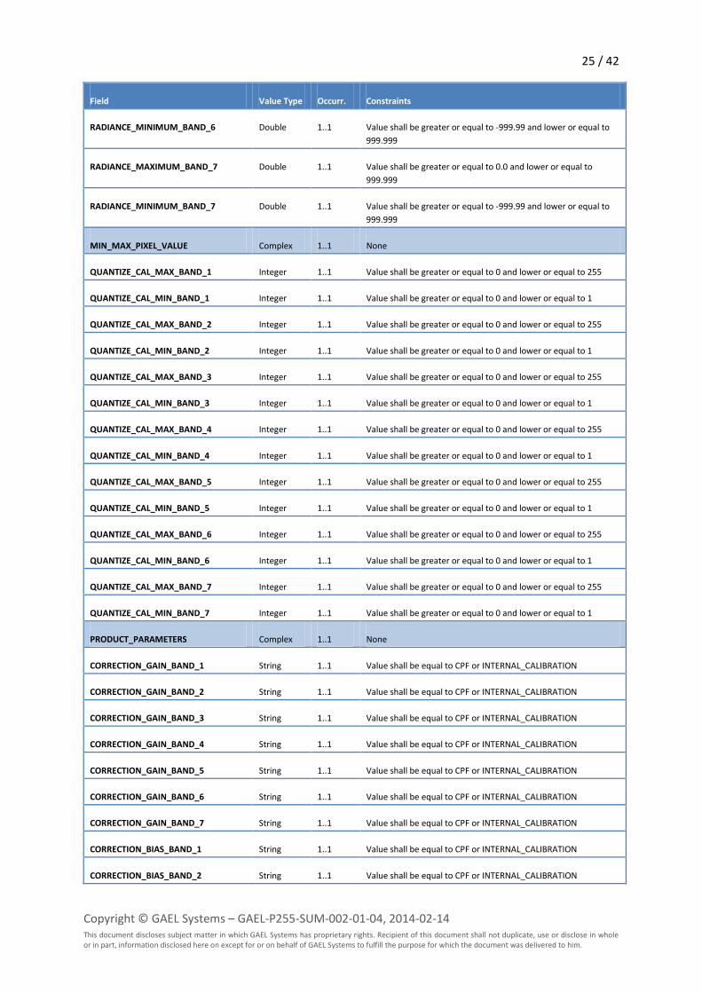
MIN_MAX_PIXEL_VALUE Complex 1..1 None
QUANTIZE_CAL_MAX_BAND_1 Integer 1..1 Value shall be greater or equal to 0 and lower or equal to 255
QUANTIZE_CAL_MIN_BAND_1 Integer 1..1 Value shall be greater or equal to 0 and lower or equal to 1
QUANTIZE_CAL_MAX_BAND_2 Integer 1..1 Value shall be greater or equal to 0 and lower or equal to 255
QUANTIZE_CAL_MIN_BAND_2 Integer 1..1 Value shall be greater or equal to 0 and lower or equal to 1
QUANTIZE_CAL_MAX_BAND_3 Integer 1..1 Value shall be greater or equal to 0 and lower or equal to 255
QUANTIZE_CAL_MIN_BAND_3 Integer 1..1 Value shall be greater or equal to 0 and lower or equal to 1
QUANTIZE_CAL_MAX_BAND_4 Integer 1..1 Value shall be greater or equal to 0 and lower or equal to 255
QUANTIZE_CAL_MIN_BAND_4 Integer 1..1 Value shall be greater or equal to 0 and lower or equal to 1
QUANTIZE_CAL_MAX_BAND_5 Integer 1..1 Value shall be greater or equal to 0 and lower or equal to 255
QUANTIZE_CAL_MIN_BAND_5 Integer 1..1 Value shall be greater or equal to 0 and lower or equal to 1
QUANTIZE_CAL_MAX_BAND_6 Integer 1..1 Value shall be greater or equal to 0 and lower or equal to 255
QUANTIZE_CAL_MIN_BAND_6 Integer 1..1 Value shall be greater or equal to 0 and lower or equal to 1
QUANTIZE_CAL_MAX_BAND_7 Integer 1..1 Value shall be greater or equal to 0 and lower or equal to 255
QUANTIZE_CAL_MIN_BAND_7 Integer 1..1 Value shall be greater or equal to 0 and lower or equal to 1
PRODUCT_PARAMETERS Complex 1..1 None
CORRECTION_GAIN_BAND_1 String 1..1 Value shall be equal to CPF or INTERNAL_CALIBRATION
CORRECTION_GAIN_BAND_2 String 1..1 Value shall be equal to CPF or INTERNAL_CALIBRATION
CORRECTION_GAIN_BAND_3 String 1..1 Value shall be equal to CPF or INTERNAL_CALIBRATION
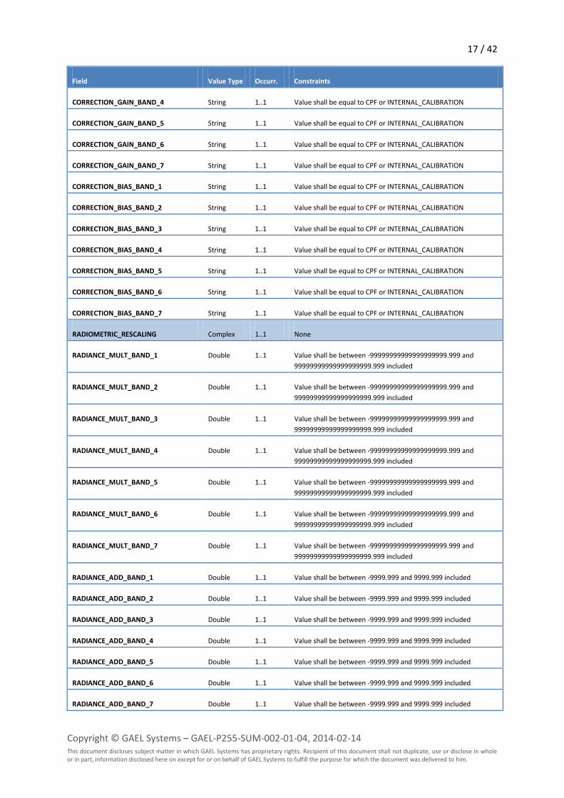
17 / 42
Copyright © GAEL Systems – GAEL-P255-SUM-002-01-04, 2014-02-14 This document discloses subject matter in which GAEL Systems has proprietary rights. Recipient of this document shall not duplicate, use or disclose in whole or in part, information disclosed here on except for or on behalf of GAEL Systems to fulfill the purpose for which the document was delivered to him.
Field Value Type Occurr. Constraints
CORRECTION_GAIN_BAND_4 String 1..1 Value shall be equal to CPF or INTERNAL_CALIBRATION
CORRECTION_GAIN_BAND_5 String 1..1 Value shall be equal to CPF or INTERNAL_CALIBRATION
CORRECTION_GAIN_BAND_6 String 1..1 Value shall be equal to CPF or INTERNAL_CALIBRATION
CORRECTION_GAIN_BAND_7 String 1..1 Value shall be equal to CPF or INTERNAL_CALIBRATION
CORRECTION_BIAS_BAND_1 String 1..1 Value shall be equal to CPF or INTERNAL_CALIBRATION
CORRECTION_BIAS_BAND_2 String 1..1 Value shall be equal to CPF or INTERNAL_CALIBRATION
CORRECTION_BIAS_BAND_3 String 1..1 Value shall be equal to CPF or INTERNAL_CALIBRATION
CORRECTION_BIAS_BAND_4 String 1..1 Value shall be equal to CPF or INTERNAL_CALIBRATION
CORRECTION_BIAS_BAND_5 String 1..1 Value shall be equal to CPF or INTERNAL_CALIBRATION
CORRECTION_BIAS_BAND_6 String 1..1 Value shall be equal to CPF or INTERNAL_CALIBRATION
CORRECTION_BIAS_BAND_7 String 1..1 Value shall be equal to CPF or INTERNAL_CALIBRATION
RADIOMETRIC_RESCALING Complex 1..1 None
RADIANCE_MULT_BAND_1 Double 1..1 Value shall be between -99999999999999999999.999 and
99999999999999999999.999 included
RADIANCE_MULT_BAND_2 Double 1..1 Value shall be between -99999999999999999999.999 and
99999999999999999999.999 included
RADIANCE_MULT_BAND_3 Double 1..1 Value shall be between -99999999999999999999.999 and
99999999999999999999.999 included
RADIANCE_MULT_BAND_4 Double 1..1 Value shall be between -99999999999999999999.999 and
99999999999999999999.999 included
RADIANCE_MULT_BAND_5 Double 1..1 Value shall be between -99999999999999999999.999 and
99999999999999999999.999 included
RADIANCE_MULT_BAND_6 Double 1..1 Value shall be between -99999999999999999999.999 and
99999999999999999999.999 included
RADIANCE_MULT_BAND_7 Double 1..1 Value shall be between -99999999999999999999.999 and
99999999999999999999.999 included
RADIANCE_ADD_BAND_1 Double 1..1 Value shall be between -9999.999 and 9999.999 included
RADIANCE_ADD_BAND_2 Double 1..1 Value shall be between -9999.999 and 9999.999 included
RADIANCE_ADD_BAND_3 Double 1..1 Value shall be between -9999.999 and 9999.999 included
RADIANCE_ADD_BAND_4 Double 1..1 Value shall be between -9999.999 and 9999.999 included
RADIANCE_ADD_BAND_5 Double 1..1 Value shall be between -9999.999 and 9999.999 included
RADIANCE_ADD_BAND_6 Double 1..1 Value shall be between -9999.999 and 9999.999 included
RADIANCE_ADD_BAND_7 Double 1..1 Value shall be between -9999.999 and 9999.999 included
18 / 42
Copyright © GAEL Systems – GAEL-P255-SUM-002-01-04, 2014-02-14 This document discloses subject matter in which GAEL Systems has proprietary rights. Recipient of this document shall not duplicate, use or disclose in whole or in part, information disclosed here on except for or on behalf of GAEL Systems to fulfill the purpose for which the document was delivered to him.
Field Value Type Occurr. Constraints
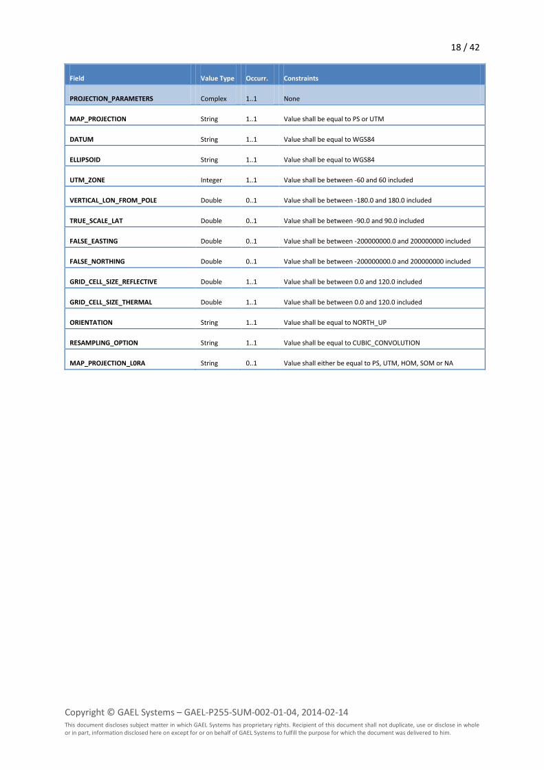
PROJECTION_PARAMETERS Complex 1..1 None
MAP_PROJECTION String 1..1 Value shall be equal to PS or UTM
DATUM String 1..1 Value shall be equal to WGS84
ELLIPSOID String 1..1 Value shall be equal to WGS84
UTM_ZONE Integer 1..1 Value shall be between -60 and 60 included
VERTICAL_LON_FROM_POLE Double 0..1 Value shall be between -180.0 and 180.0 included
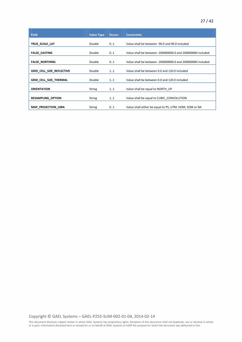
TRUE_SCALE_LAT Double 0..1 Value shall be between -90.0 and 90.0 included
FALSE_EASTING Double 0..1 Value shall be between -200000000.0 and 200000000 included
FALSE_NORTHING Double 0..1 Value shall be between -200000000.0 and 200000000 included
GRID_CELL_SIZE_REFLECTIVE Double 1..1 Value shall be between 0.0 and 120.0 included
GRID_CELL_SIZE_THERMAL Double 1..1 Value shall be between 0.0 and 120.0 included
ORIENTATION String 1..1 Value shall be equal to NORTH_UP
RESAMPLING_OPTION String 1..1 Value shall be equal to CUBIC_CONVOLUTION
MAP_PROJECTION_L0RA String 0..1 Value shall either be equal to PS, UTM, HOM, SOM or NA
19 / 42
Copyright © GAEL Systems – GAEL-P255-SUM-002-01-04, 2014-02-14 This document discloses subject matter in which GAEL Systems has proprietary rights. Recipient of this document shall not duplicate, use or disclose in whole or in part, information disclosed here on except for or on behalf of GAEL Systems to fulfill the purpose for which the document was delivered to him.
Landsat ETM+ GeoTIFF Products
The following inspection plan is applied to any Landsat ETM+ L1T GeoTIFF Product.
Note – First complete version since amalfi-esa-sppa-landsat-1.0.8.
Note – since amalfi-esa-sppa-landsat-1.0.10, output reports of products acquired in SLC-OFF mode
(i.e. acquired after 2003-05-31T21:30:00 excluded) include the following disclaimer in a headline
section:
“On May the 31st, 2003, the Scan Line Corrector (SLC) on board the Landsat 7 instrument suffered a total failure, which
impacted the quality of the acquired images, with areas in the centre of the image being acquired twice and those at the
edge of the image not being acquired at all. More information on the behaviour of the SLC can be found on the USGS site
here: http://landsat.usgs.gov/products_slcoffbackground.php.
As a result of this failure, and its impact on products, routine acquisition of Landsat ETM+ data by ESA was halted in May
2003. This product is not part of a routine acquisition, therefore should be used with caution.
Additional information on methods to overcome the gaps within products resulting from the failure in the SLC can be found
here: http://landsat.usgs.gov/using_Landsat_7_data.php.”
Name Inspector Criteria Description
TM L1 Metadata (MTL) Inspection
Plan
Plan Fails upon any sub-
inspection failure
The top level inspection plan for TM L1 Metadata
(MTL) file
TM File Name Pattern XQuery Fails if the pattern
does not match the
specifications
Controls that the actual metadata file name
conforms to the one specified in the [LS-DFCB-04]
XML Schema Validation XML Schema Fails upon any
validation error
Applies the Metadata file XML Schema included in
the DRB Cortex Topic and applicable to the ETM+
Metadata file i.e. the ls-dfcb-04-v15.0-mtl.xsd file
included in the DRBx-cortex-topic-landsat-usgs:jar
package (introduced in earlier chapters). The
quality controlled applied to each element is
defined in the table following the present one.
Creation Time XQuery Fails if the data
structure does not
conform to ISO 8601
standard
Extracts and verifies that the
METADATA_FILE_INFO/FILE_DATE field conforms
to the ISO 8610 standard
Sensor Mode Inspection XQuery Fails if the sensor
mode does not
match the allowed
period for the
acquiring platform
Extracts and verifies that the
PRODUCT_METADATA /SENSOR_MODE field is
correct according to the
PRODUCT_METADATA/DATE_ACQUIRED. For
Landsat 5 TM, the sensor mode is supposed to be
SAM up to 2002-03-01T00:00:00 and BUMPER
after this date. For Landsat 4 the mode shall
always be SAM.
Acquisition Date Inspection XQuery Fails if the acquisition
date is outside the
actual operational
Extracts and verifies that the
PRODUCT_METADATA /DATE_ACQUIRED field is
correct according to the actual operational period
20 / 42
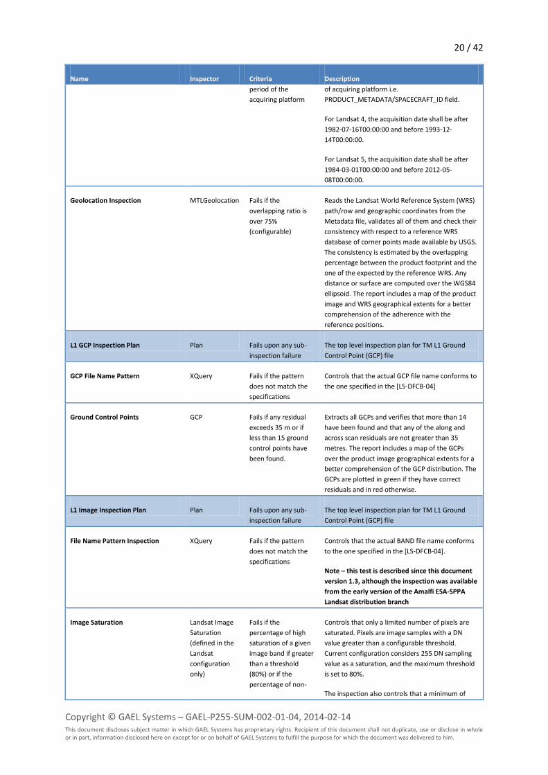
Copyright © GAEL Systems – GAEL-P255-SUM-002-01-04, 2014-02-14 This document discloses subject matter in which GAEL Systems has proprietary rights. Recipient of this document shall not duplicate, use or disclose in whole or in part, information disclosed here on except for or on behalf of GAEL Systems to fulfill the purpose for which the document was delivered to him.
Name Inspector Criteria Description
period of the
acquiring platform
of acquiring platform i.e.
PRODUCT_METADATA/SPACECRAFT_ID field.
For Landsat 4, the acquisition date shall be after
1982-07-16T00:00:00 and before 1993-12-
14T00:00:00.
For Landsat 5, the acquisition date shall be after
1984-03-01T00:00:00 and before 2012-05-
08T00:00:00.
Geolocation Inspection MTLGeolocation Fails if the
overlapping ratio is
over 75%
(configurable)
Reads the Landsat World Reference System (WRS)
path/row and geographic coordinates from the
Metadata file, validates all of them and check their
consistency with respect to a reference WRS
database of corner points made available by USGS.
The consistency is estimated by the overlapping
percentage between the product footprint and the
one of the expected by the reference WRS. Any
distance or surface are computed over the WGS84
ellipsoid. The report includes a map of the product
image and WRS geographical extents for a better
comprehension of the adherence with the
reference positions.
L1 GCP Inspection Plan Plan Fails upon any sub-
inspection failure
The top level inspection plan for TM L1 Ground
Control Point (GCP) file
GCP File Name Pattern XQuery Fails if the pattern
does not match the
specifications
Controls that the actual GCP file name conforms to
the one specified in the [LS-DFCB-04]
Ground Control Points GCP Fails if any residual
exceeds 35 m or if
less than 15 ground
control points have
been found.
Extracts all GCPs and verifies that more than 14
have been found and that any of the along and
across scan residuals are not greater than 35
metres. The report includes a map of the GCPs
over the product image geographical extents for a
better comprehension of the GCP distribution. The
GCPs are plotted in green if they have correct
residuals and in red otherwise.
L1 Image Inspection Plan Plan Fails upon any sub-
inspection failure
The top level inspection plan for TM L1 Ground
Control Point (GCP) file
File Name Pattern Inspection XQuery Fails if the pattern
does not match the
specifications
Controls that the actual BAND file name conforms
to the one specified in the [LS-DFCB-04].
Note – this test is described since this document
version 1.3, although the inspection was available
from the early version of the Amalfi ESA-SPPA
Landsat distribution branch
Image Saturation Landsat Image
Saturation
(defined in the
Landsat
configuration
only)
Fails if the
percentage of high
saturation of a given
image band if greater
than a threshold
(80%) or if the
percentage of non-
Controls that only a limited number of pixels are
saturated. Pixels are image samples with a DN
value greater than a configurable threshold.
Current configuration considers 255 DN sampling
value as a saturation, and the maximum threshold
is set to 80%.
The inspection also controls that a minimum of

21 / 42
Copyright © GAEL Systems – GAEL-P255-SUM-002-01-04, 2014-02-14 This document discloses subject matter in which GAEL Systems has proprietary rights. Recipient of this document shall not duplicate, use or disclose in whole or in part, information disclosed here on except for or on behalf of GAEL Systems to fulfill the purpose for which the document was delivered to him.
Name Inspector Criteria Description
background pixels is
lower than a
threshold (5%).
non-background pixels are present in the band.
The goal of this test is to identify empty images
composed only of background pixels (i.e. 0 DN in
current configuration) such observed in output of
some development versions of the ESA Landsat
Instrument Processing Facility (IPF). The current
configuration consider empty, a band that contains
less than 5% of non-background pixels.
Note – this test is described since this document
version 1.3, although the inspection was available
from the early version of the Amalfi configuration
for Landsat
Note – since amalfi-esa-sppa-landsat-1.0.9, this
inspection was limited to high saturation.
Previous versions were including a low saturation
tests that was impracticable for Landsat products.
Image Striping Image Striping Fails if the one or
more spectral peaks
of DFT analysis of
performed on several
locations of the band
are over a threshold
(1.8).
Controls that none of the Direct Fourier Transform
analyses performed on sub-windows evenly
extracted from an image band has a spectral peak
over a configurable threshold.
The current configuration defines window of
256x256, a minimal period of 16, a density of 16
with a minimal standard deviation of 0.9.
Note – this test is described since this document
version 1.3, although the inspection was available
from the early version of the Amalfi configuration
for Landsat
Note – since amalfi-esa-sppa-landsat-1.0.10, this
inspection is applied only for products acquired in
SLC-ON mode i.e. acquired before 2003-05-
31T21:30:00 included.
The following table details the constraints verified during the XML Schema validation of the
Metadata (MTL) file.
Field Value Type Occurr. Constraints
METADATA_FILE_INFO Complex 1..1 None
ORIGIN String 1..1 Value shall have an length between 1 and 47 characters
REQUEST_ID String 1..1 Value shall have an length between 1 and 20 characters
LANDSAT_SCENE_ID String 1..1 Value shall match the pattern "LT[45]\d{3}\d{3}\d{4}\d{3}...\d{2}"
FILE_DATE dateTime 1..1 ISO 8610 formatted
STATION_ID String 1..1 Value shall have a length equal to 3
22 / 42
Copyright © GAEL Systems – GAEL-P255-SUM-002-01-04, 2014-02-14 This document discloses subject matter in which GAEL Systems has proprietary rights. Recipient of this document shall not duplicate, use or disclose in whole or in part, information disclosed here on except for or on behalf of GAEL Systems to fulfill the purpose for which the document was delivered to him.
Field Value Type Occurr. Constraints
PROCESSING_SOFTWARE_VERSION String 1..1 Value shall have an length between 1 and 20 characters and
match the pattern "\w+_\d+\.\d+(\.\d+)*"
DATA_CATEGORY String 1..1 Value shall be either NOMINAL, VALIDATION, EXCHANGE, TEST or
ENGINEERING
PRODUCT_METADATA Complex 1..1 None
DATA_TYPE String 1..1 Value shall be either L1G, L1GT or L1T
ELEVATION_SOURCE String 0..1 Value shall be either NED, SRTM1, SRTM3, GTOPO30, GLS2000
Note – since amalfi-esa-sppa-landsat-1.0.7, this field is not
mandatory for levels different from L1T
OUTPUT_FORMAT String 1..1 Value shall be equal to GEOTIFF
EPHEMERIS_TYPE String 1..1 Value shall be either DEFINITIVE, PREDICTIVE or RESTITUTED
Note – the RESTITUTED value has been added since amalfi-esa-
sppa-landsat-1.0.8
SPACECRAFT_ID String 1..1 Value shall be either LANDSAT_4 or LANDSAT_5
SENSOR_ID String 1..1 Value shall be equal to TM
SENSOR_MODE String 1..1 Value shall be either SAM or BUMPER
WRS_PATH Integer 1..1 Value shall be included between 1 and 251
WRS_ROW Integer 1..1 Value shall be included between 1 and 248
DATE_ACQUIRED String 1..1 Value shall match the pattern "\d{4}-\d{2}-\d{2}"
SCENE_CENTER_TIME String 1..1 Value shall match the pattern "\d{2}:\d{2}:\d{2}\.\d{7}Z"
CORNER_UL_LAT_PRODUCT Double 1..1 Value shall be included between -90.0 and 90.0
CORNER_UL_LON_PRODUCT Double 1..1 Value shall be included between -180.0 and 180.0
CORNER_UR_LAT_PRODUCT Double 1..1 Value shall be included between -90.0 and 90.0
CORNER_UR_LON_PRODUCT Double 1..1 Value shall be included between -180.0 and 180.0
CORNER_LL_LAT_PRODUCT Double 1..1 Value shall be included between -90.0 and 90.0
CORNER_LL_LON_PRODUCT Double 1..1 Value shall be included between -180.0 and 180.0
CORNER_LR_LAT_PRODUCT Double 1..1 Value shall be included between -90.0 and 90.0
CORNER_LR_LON_PRODUCT Double 1..1 Value shall be included between -180.0 and 180.0
CORNER_UL_PROJECTION_X_PRODUCT Double 1..1 Value shall be included between -132000000.000 and
132000000.000
CORNER_UL_PROJECTION_Y_PRODUCT Double 1..1 Value shall be included between -132000000.000 and
132000000.000

23 / 42
Copyright © GAEL Systems – GAEL-P255-SUM-002-01-04, 2014-02-14 This document discloses subject matter in which GAEL Systems has proprietary rights. Recipient of this document shall not duplicate, use or disclose in whole or in part, information disclosed here on except for or on behalf of GAEL Systems to fulfill the purpose for which the document was delivered to him.
Field Value Type Occurr. Constraints
CORNER_UR_PROJECTION_X_PRODUCT Double 1..1 Value shall be included between -132000000.000 and
132000000.000
CORNER_UR_PROJECTION_Y_PRODUCT Double 1..1 Value shall be included between -132000000.000 and
132000000.000
CORNER_LR_PROJECTION_X_PRODUCT Double 1..1 Value shall be included between -132000000.000 and
132000000.000
CORNER_LR_PROJECTION_Y_PRODUCT Double 1..1 Value shall be included between -132000000.000 and
132000000.000
CORNER_LL_PROJECTION_X_PRODUCT Double 1..1 Value shall be included between -132000000.000 and
132000000.000
CORNER_LL_PROJECTION_Y_PRODUCT Double 1..1 Value shall be included between -132000000.000 and
132000000.000
REFLECTIVE_LINES Integer 1..1 Value shall be greater or equal to 1
REFLECTIVE_SAMPLES Integer 1..1 Value shall be greater or equal to 1
THERMAL_LINES Integer 1..1 Value shall be greater or equal to 1
THERMAL_SAMPLES Integer 1..1 Value shall be greater or equal to 1
FILE_NAME_BAND_1 String 0..1 Value shall match "LT[45]\d{3}\d{3}\d{4}\d{3}...\d{2}_B1\.TIF"
FILE_NAME_BAND_2 String 0..1 Value shall match "LT[45]\d{3}\d{3}\d{4}\d{3}...\d{2}_B2\.TIF"
FILE_NAME_BAND_3 String 0..1 Value shall match "LT[45]\d{3}\d{3}\d{4}\d{3}...\d{2}_B3\.TIF"
FILE_NAME_BAND_4 String 0..1 Value shall match "LT[45]\d{3}\d{3}\d{4}\d{3}...\d{2}_B4\.TIF"
FILE_NAME_BAND_5 String 0..1 Value shall match "LT[45]\d{3}\d{3}\d{4}\d{3}...\d{2}_B5\.TIF"
FILE_NAME_BAND_6 String 0..1 Value shall match "LT[45]\d{3}\d{3}\d{4}\d{3}...\d{2}_B6\.TIF"
FILE_NAME_BAND_7 String 0..1 Value shall match "LT[45]\d{3}\d{3}\d{4}\d{3}...\d{2}_B7\.TIF"
REPORT_VERIFY_FILE_NAME String 0..1 Value shall match "LT[45]\d{3}\d{3}\d{4}\d{3}...\d{2}_VER\.txt"
BROWSE_VERIFY_FILE_NAME String 0..1 Value shall match "LT[45]\d{3}\d{3}\d{4}\d{3}...\d{2}_VER\.jpg"
METADATA_FILE_NAME String 1..1 Value shall match "LT[45]\d{3}\d{3}\d{4}\d{3}...\d{2}_MTL\.txt"
CPF_NAME String 1..1 Value shall match
"L[45]CPF\d{4}\d{2}\d{2}_\d{4}\d{2}\d{2}\.\d{2}"
IMAGE_ATTRIBUTES Complex 1..1 None
CLOUD_COVER Double 1..1 Value shall be greater or equal to -1.0 and lower or equal to 100.0
IMAGE_QUALITY Integer 1..1 Value shall be greater or equal to -1 and lower or equal to 9

24 / 42
Copyright © GAEL Systems – GAEL-P255-SUM-002-01-04, 2014-02-14 This document discloses subject matter in which GAEL Systems has proprietary rights. Recipient of this document shall not duplicate, use or disclose in whole or in part, information disclosed here on except for or on behalf of GAEL Systems to fulfill the purpose for which the document was delivered to him.
Field Value Type Occurr. Constraints
SUN_AZIMUTH Double 1..1 Value shall be greater than -180.0 and lower or equal to 180.0
Note – since amalfi-esa-sppa-landsat-1.0.7, this fields extents
have been restored to DFCB values. Previous versions were
following the ESA IPF that up to this release was wrongly
considering -90, 90 range.
SUN_ELEVATION Double 1..1 Value shall be greater or equal to -90.0 and lower or equal to 90.0
GROUND_CONTROL_POINTS_MODEL Integer 0..1 Value shall be greater or equal to 0 and lower or equal to 999
Note – since amalfi-esa-sppa-landsat-1.0.7, this field is not
mandatory for levels different from L1T
GEOMETRIC_RMSE_MODEL Double 0..1 Value shall be greater or equal to 0.0 and lower or equal to
9999.999
GEOMETRIC_RMSE_MODEL_Y Double 0..1 Value shall be greater or equal to 0.0 and lower or equal to
9999.999
GEOMETRIC_RMSE_MODEL_X Double 0..1 Value shall be greater or equal to 0.0 and lower or equal to
9999.999
MIN_MAX_RADIANCE Complex 1..1 None
RADIANCE_MAXIMUM_BAND_1 Double 1..1 Value shall be greater or equal to 0.0 and lower or equal to
999.999
RADIANCE_MINIMUM_BAND_1 Double 1..1 Value shall be greater or equal to -999.99 and lower or equal to
999.999
RADIANCE_MAXIMUM_BAND_2 Double 1..1 Value shall be greater or equal to 0.0 and lower or equal to
999.999
RADIANCE_MINIMUM_BAND_2 Double 1..1 Value shall be greater or equal to -999.99 and lower or equal to
999.999
RADIANCE_MAXIMUM_BAND_3 Double 1..1 Value shall be greater or equal to 0.0 and lower or equal to
999.999
RADIANCE_MINIMUM_BAND_3 Double 1..1 Value shall be greater or equal to -999.99 and lower or equal to
999.999
RADIANCE_MAXIMUM_BAND_4 Double 1..1 Value shall be greater or equal to 0.0 and lower or equal to
999.999
RADIANCE_MINIMUM_BAND_4 Double 1..1 Value shall be greater or equal to -999.99 and lower or equal to
999.999
RADIANCE_MAXIMUM_BAND_5 Double 1..1 Value shall be greater or equal to 0.0 and lower or equal to
999.999
RADIANCE_MINIMUM_BAND_5 Double 1..1 Value shall be greater or equal to -999.99 and lower or equal to
999.999
RADIANCE_MAXIMUM_BAND_6 Double 1..1 Value shall be greater or equal to 0.0 and lower or equal to
999.999
25 / 42
Copyright © GAEL Systems – GAEL-P255-SUM-002-01-04, 2014-02-14 This document discloses subject matter in which GAEL Systems has proprietary rights. Recipient of this document shall not duplicate, use or disclose in whole or in part, information disclosed here on except for or on behalf of GAEL Systems to fulfill the purpose for which the document was delivered to him.
Field Value Type Occurr. Constraints
RADIANCE_MINIMUM_BAND_6 Double 1..1 Value shall be greater or equal to -999.99 and lower or equal to
999.999
RADIANCE_MAXIMUM_BAND_7 Double 1..1 Value shall be greater or equal to 0.0 and lower or equal to
999.999
RADIANCE_MINIMUM_BAND_7 Double 1..1 Value shall be greater or equal to -999.99 and lower or equal to
999.999
MIN_MAX_PIXEL_VALUE Complex 1..1 None
QUANTIZE_CAL_MAX_BAND_1 Integer 1..1 Value shall be greater or equal to 0 and lower or equal to 255
QUANTIZE_CAL_MIN_BAND_1 Integer 1..1 Value shall be greater or equal to 0 and lower or equal to 1
QUANTIZE_CAL_MAX_BAND_2 Integer 1..1 Value shall be greater or equal to 0 and lower or equal to 255
QUANTIZE_CAL_MIN_BAND_2 Integer 1..1 Value shall be greater or equal to 0 and lower or equal to 1
QUANTIZE_CAL_MAX_BAND_3 Integer 1..1 Value shall be greater or equal to 0 and lower or equal to 255
QUANTIZE_CAL_MIN_BAND_3 Integer 1..1 Value shall be greater or equal to 0 and lower or equal to 1
QUANTIZE_CAL_MAX_BAND_4 Integer 1..1 Value shall be greater or equal to 0 and lower or equal to 255
QUANTIZE_CAL_MIN_BAND_4 Integer 1..1 Value shall be greater or equal to 0 and lower or equal to 1
QUANTIZE_CAL_MAX_BAND_5 Integer 1..1 Value shall be greater or equal to 0 and lower or equal to 255
QUANTIZE_CAL_MIN_BAND_5 Integer 1..1 Value shall be greater or equal to 0 and lower or equal to 1
QUANTIZE_CAL_MAX_BAND_6 Integer 1..1 Value shall be greater or equal to 0 and lower or equal to 255
QUANTIZE_CAL_MIN_BAND_6 Integer 1..1 Value shall be greater or equal to 0 and lower or equal to 1
QUANTIZE_CAL_MAX_BAND_7 Integer 1..1 Value shall be greater or equal to 0 and lower or equal to 255
QUANTIZE_CAL_MIN_BAND_7 Integer 1..1 Value shall be greater or equal to 0 and lower or equal to 1
PRODUCT_PARAMETERS Complex 1..1 None
CORRECTION_GAIN_BAND_1 String 1..1 Value shall be equal to CPF or INTERNAL_CALIBRATION
CORRECTION_GAIN_BAND_2 String 1..1 Value shall be equal to CPF or INTERNAL_CALIBRATION
CORRECTION_GAIN_BAND_3 String 1..1 Value shall be equal to CPF or INTERNAL_CALIBRATION
CORRECTION_GAIN_BAND_4 String 1..1 Value shall be equal to CPF or INTERNAL_CALIBRATION
CORRECTION_GAIN_BAND_5 String 1..1 Value shall be equal to CPF or INTERNAL_CALIBRATION
CORRECTION_GAIN_BAND_6 String 1..1 Value shall be equal to CPF or INTERNAL_CALIBRATION
CORRECTION_GAIN_BAND_7 String 1..1 Value shall be equal to CPF or INTERNAL_CALIBRATION
CORRECTION_BIAS_BAND_1 String 1..1 Value shall be equal to CPF or INTERNAL_CALIBRATION
CORRECTION_BIAS_BAND_2 String 1..1 Value shall be equal to CPF or INTERNAL_CALIBRATION
26 / 42
Copyright © GAEL Systems – GAEL-P255-SUM-002-01-04, 2014-02-14 This document discloses subject matter in which GAEL Systems has proprietary rights. Recipient of this document shall not duplicate, use or disclose in whole or in part, information disclosed here on except for or on behalf of GAEL Systems to fulfill the purpose for which the document was delivered to him.
Field Value Type Occurr. Constraints
CORRECTION_BIAS_BAND_3 String 1..1 Value shall be equal to CPF or INTERNAL_CALIBRATION
CORRECTION_BIAS_BAND_4 String 1..1 Value shall be equal to CPF or INTERNAL_CALIBRATION
CORRECTION_BIAS_BAND_5 String 1..1 Value shall be equal to CPF or INTERNAL_CALIBRATION
CORRECTION_BIAS_BAND_6 String 1..1 Value shall be equal to CPF or INTERNAL_CALIBRATION
CORRECTION_BIAS_BAND_7 String 1..1 Value shall be equal to CPF or INTERNAL_CALIBRATION
RADIOMETRIC_RESCALING Complex 1..1 None
RADIANCE_MULT_BAND_1 Double 1..1 Value shall be between -99999999999999999999.999 and
99999999999999999999.999 included
RADIANCE_MULT_BAND_2 Double 1..1 Value shall be between -99999999999999999999.999 and
99999999999999999999.999 included
RADIANCE_MULT_BAND_3 Double 1..1 Value shall be between -99999999999999999999.999 and
99999999999999999999.999 included
RADIANCE_MULT_BAND_4 Double 1..1 Value shall be between -99999999999999999999.999 and
99999999999999999999.999 included
RADIANCE_MULT_BAND_5 Double 1..1 Value shall be between -99999999999999999999.999 and
99999999999999999999.999 included
RADIANCE_MULT_BAND_6 Double 1..1 Value shall be between -99999999999999999999.999 and
99999999999999999999.999 included
RADIANCE_MULT_BAND_7 Double 1..1 Value shall be between -99999999999999999999.999 and
99999999999999999999.999 included
RADIANCE_ADD_BAND_1 Double 1..1 Value shall be between -9999.999 and 9999.999 included
RADIANCE_ADD_BAND_2 Double 1..1 Value shall be between -9999.999 and 9999.999 included
RADIANCE_ADD_BAND_3 Double 1..1 Value shall be between -9999.999 and 9999.999 included
RADIANCE_ADD_BAND_4 Double 1..1 Value shall be between -9999.999 and 9999.999 included
RADIANCE_ADD_BAND_5 Double 1..1 Value shall be between -9999.999 and 9999.999 included
RADIANCE_ADD_BAND_6 Double 1..1 Value shall be between -9999.999 and 9999.999 included
RADIANCE_ADD_BAND_7 Double 1..1 Value shall be between -9999.999 and 9999.999 included
PROJECTION_PARAMETERS Complex 1..1 None
MAP_PROJECTION String 1..1 Value shall be equal to PS or UTM
DATUM String 1..1 Value shall be equal to WGS84
ELLIPSOID String 1..1 Value shall be equal to WGS84
UTM_ZONE Integer 1..1 Value shall be between -60 and 60 included
VERTICAL_LON_FROM_POLE Double 0..1 Value shall be between -180.0 and 180.0 included
27 / 42
Copyright © GAEL Systems – GAEL-P255-SUM-002-01-04, 2014-02-14 This document discloses subject matter in which GAEL Systems has proprietary rights. Recipient of this document shall not duplicate, use or disclose in whole or in part, information disclosed here on except for or on behalf of GAEL Systems to fulfill the purpose for which the document was delivered to him.
Field Value Type Occurr. Constraints
TRUE_SCALE_LAT Double 0..1 Value shall be between -90.0 and 90.0 included
FALSE_EASTING Double 0..1 Value shall be between -200000000.0 and 200000000 included
FALSE_NORTHING Double 0..1 Value shall be between -200000000.0 and 200000000 included
GRID_CELL_SIZE_REFLECTIVE Double 1..1 Value shall be between 0.0 and 120.0 included
GRID_CELL_SIZE_THERMAL Double 1..1 Value shall be between 0.0 and 120.0 included
ORIENTATION String 1..1 Value shall be equal to NORTH_UP
RESAMPLING_OPTION String 1..1 Value shall be equal to CUBIC_CONVOLUTION
MAP_PROJECTION_L0RA String 0..1 Value shall either be equal to PS, UTM, HOM, SOM or NA
28 / 42
Copyright © GAEL Systems – GAEL-P255-SUM-002-01-04, 2014-02-14 This document discloses subject matter in which GAEL Systems has proprietary rights. Recipient of this document shall not duplicate, use or disclose in whole or in part, information disclosed here on except for or on behalf of GAEL Systems to fulfill the purpose for which the document was delivered to him.
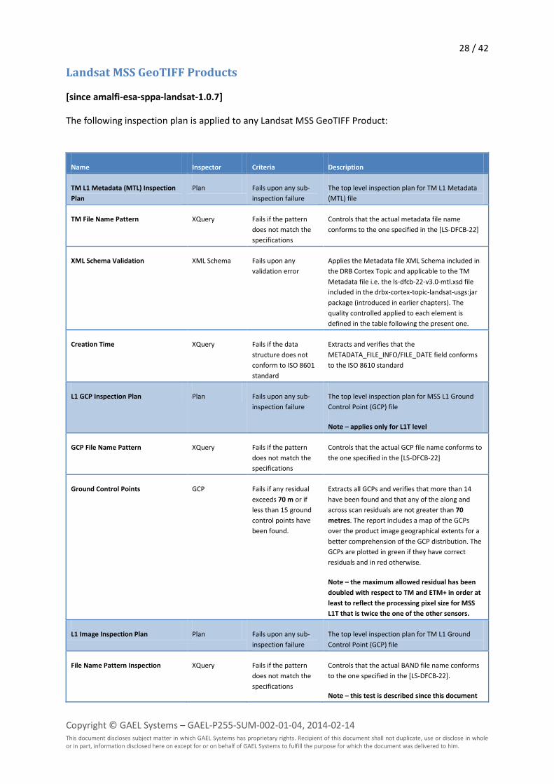
Landsat MSS GeoTIFF Products
[since amalfi-esa-sppa-landsat-1.0.7]
The following inspection plan is applied to any Landsat MSS GeoTIFF Product:
Name Inspector Criteria Description
TM L1 Metadata (MTL) Inspection
Plan
Plan Fails upon any sub-
inspection failure
The top level inspection plan for TM L1 Metadata
(MTL) file
TM File Name Pattern XQuery Fails if the pattern
does not match the
specifications
Controls that the actual metadata file name
conforms to the one specified in the [LS-DFCB-22]
XML Schema Validation XML Schema Fails upon any
validation error
Applies the Metadata file XML Schema included in
the DRB Cortex Topic and applicable to the TM
Metadata file i.e. the ls-dfcb-22-v3.0-mtl.xsd file
included in the drbx-cortex-topic-landsat-usgs:jar
package (introduced in earlier chapters). The
quality controlled applied to each element is
defined in the table following the present one.
Creation Time XQuery Fails if the data
structure does not
conform to ISO 8601
standard
Extracts and verifies that the
METADATA_FILE_INFO/FILE_DATE field conforms
to the ISO 8610 standard
L1 GCP Inspection Plan Plan Fails upon any sub-
inspection failure
The top level inspection plan for MSS L1 Ground
Control Point (GCP) file
Note – applies only for L1T level
GCP File Name Pattern XQuery Fails if the pattern
does not match the
specifications
Controls that the actual GCP file name conforms to
the one specified in the [LS-DFCB-22]
Ground Control Points GCP Fails if any residual
exceeds 70 m or if
less than 15 ground
control points have
been found.
Extracts all GCPs and verifies that more than 14
have been found and that any of the along and
across scan residuals are not greater than 70
metres. The report includes a map of the GCPs
over the product image geographical extents for a
better comprehension of the GCP distribution. The
GCPs are plotted in green if they have correct
residuals and in red otherwise.
Note – the maximum allowed residual has been
doubled with respect to TM and ETM+ in order at
least to reflect the processing pixel size for MSS
L1T that is twice the one of the other sensors.
L1 Image Inspection Plan Plan Fails upon any sub-
inspection failure
The top level inspection plan for TM L1 Ground
Control Point (GCP) file
File Name Pattern Inspection XQuery Fails if the pattern
does not match the
specifications
Controls that the actual BAND file name conforms
to the one specified in the [LS-DFCB-22].
Note – this test is described since this document
29 / 42
Copyright © GAEL Systems – GAEL-P255-SUM-002-01-04, 2014-02-14 This document discloses subject matter in which GAEL Systems has proprietary rights. Recipient of this document shall not duplicate, use or disclose in whole or in part, information disclosed here on except for or on behalf of GAEL Systems to fulfill the purpose for which the document was delivered to him.
Name Inspector Criteria Description
version 1.3, although the inspection was available
from the early version of the Amalfi ESA-SPPA
Landsat distribution branch
Image Saturation Landsat Image
Saturation
(defined in the
Landsat
configuration
only)
Fails if the
percentage of high
saturation of a given
image band if greater
than a threshold
(80%) or if the
percentage of non-
background pixels is
lower than a
threshold (5%).
Controls that only a limited number of pixels are
saturated. Pixels are image samples with a DN
value greater than a configurable threshold.
Current configuration considers 255 DN sampling
value as a saturation, and the maximum threshold
is set to 80%.
The inspection also controls that a minimum of
non-background pixels are present in the band.
The goal of this test is to identify empty images
composed only of background pixels (i.e. 0 DN in
current configuration) such observed in output of
some development versions of the ESA Landsat
Instrument Processing Facility (IPF). The current
configuration consider empty, a band that contains
less than 5% of non-background pixels.
Note – this test is described since this document
version 1.3, although the inspection was available
from the early version of the Amalfi configuration
for Landsat
Note – since amalfi-esa-sppa-landsat-1.0.9, this
inspection was limited to high saturation.
Previous versions were including a low saturation
tests that was impracticable for Landsat products.
Image Striping Image Striping Fails if the one or
more spectral peaks
of DFT analysis of
performed on several
locations of the band
are over a threshold
(1.8).
Controls that none of the Direct Fourier Transform
analyses performed on sub-windows evenly
extracted from an image band has a spectral peak
over a configurable threshold.
The current configuration defines window of
256x256, a minimal period of 16, a density of 16
with a minimal standard deviation of 0.9.
Note – this test is described since this document
version 1.3, although the inspection was available
from the early version of the Amalfi configuration
for Landsat
The following table details the constraints verified during the XML Schema validation of the
Metadata (MTL) file.
Field Value Type Occurr. Constaints
METADATA_FILE_INFO Complex 1..1 None
ORIGIN String 1..1 Value shall have an length between 1 and 47 characters

30 / 42
Copyright © GAEL Systems – GAEL-P255-SUM-002-01-04, 2014-02-14 This document discloses subject matter in which GAEL Systems has proprietary rights. Recipient of this document shall not duplicate, use or disclose in whole or in part, information disclosed here on except for or on behalf of GAEL Systems to fulfill the purpose for which the document was delivered to him.
Field Value Type Occurr. Constaints
REQUEST_ID String 1..1 Value shall have an length between 1 and 20 characters
Note – DFCB limits the length of this field to 19. The maximum
length has however been set to 20, as for TM, on request of ESA
LANDSAT_SCENE_ID String 1..1 Value shall match the pattern "LM[1-
5]\d{3}\d{3}\d{4}\d{3}...\d{2}"
FILE_DATE dateTime 1..1 ISO 8610 formatted
STATION_ID String 1..1 Value shall have a length equal to 3
PROCESSING_SOFTWARE_VERSION String 1..1 Value shall have an length between 1 and 20 characters and
match the pattern "\w+_\d+\.\d+(\.\d+)*"
DATA_CATEGORY String 1..1 Value shall be either NOMINAL, VALIDATION, EXCHANGE, TEST or
ENGINEERING
PRODUCT_METADATA Complex 1..1 None
DATA_TYPE String 1..1 Value shall be either L1G, L1GT or L1T
Note – DFCB allows L1GT pattern also MS products are not
supposed to be generated at this level
DATA_TYPE_L0R String 0..1 Value shall be either MSSA_L0RP, MSSX_L0RP or MSSP_L0RP
ELEVATION_SOURCE String 0..1 Value shall be either GLS2000 or RAMP
OUTPUT_FORMAT String 1..1 Value shall be equal to GEOTIFF
EPHEMERIS_TYPE String 1..1 Value shall be either DEFINITIVE, PREDICTIVE or RESTITUTED
Note – the RESTITUTED value has been added since amalfi-esa-
sppa-landsat-1.0.8
SPACECRAFT_ID String 1..1 Value shall be either LANDSAT_1, LANDSAT_2, LANDSAT_3,
LANDSAT_4 or LANDSAT_5
SENSOR_ID String 1..1 Value shall be equal to MSS
WRS_PATH Integer 1..1 Value shall be included between 1 and 251
WRS_ROW Integer 1..1 Value shall be included between 1 and 248
DATE_ACQUIRED String 1..1 Value shall match the pattern "\d{4}-\d{2}-\d{2}"
SCENE_CENTER_TIME String 1..1 Value shall match the pattern "\d{2}:\d{2}:\d{2}\.\d{7}Z"
CORNER_UL_LAT_PRODUCT Double 1..1 Value shall be included between -90.0 and 90.0
CORNER_UL_LON_PRODUCT Double 1..1 Value shall be included between -180.0 and 180.0
CORNER_UR_LAT_PRODUCT Double 1..1 Value shall be included between -90.0 and 90.0
CORNER_UR_LON_PRODUCT Double 1..1 Value shall be included between -180.0 and 180.0
CORNER_LL_LAT_PRODUCT Double 1..1 Value shall be included between -90.0 and 90.0

31 / 42
Copyright © GAEL Systems – GAEL-P255-SUM-002-01-04, 2014-02-14 This document discloses subject matter in which GAEL Systems has proprietary rights. Recipient of this document shall not duplicate, use or disclose in whole or in part, information disclosed here on except for or on behalf of GAEL Systems to fulfill the purpose for which the document was delivered to him.
Field Value Type Occurr. Constaints
CORNER_LL_LON_PRODUCT Double 1..1 Value shall be included between -180.0 and 180.0
CORNER_LR_LAT_PRODUCT Double 1..1 Value shall be included between -90.0 and 90.0
CORNER_LR_LON_PRODUCT Double 1..1 Value shall be included between -180.0 and 180.0
CORNER_UL_PROJECTION_X_PRODUCT Double 1..1 Value shall be included between -132000000.000 and
132000000.000
CORNER_UL_PROJECTION_Y_PRODUCT Double 1..1 Value shall be included between -132000000.000 and
132000000.000
CORNER_UR_PROJECTION_X_PRODUCT Double 1..1 Value shall be included between -132000000.000 and
132000000.000
CORNER_UR_PROJECTION_Y_PRODUCT Double 1..1 Value shall be included between -132000000.000 and
132000000.000
CORNER_LR_PROJECTION_X_PRODUCT Double 1..1 Value shall be included between -132000000.000 and
132000000.000
CORNER_LR_PROJECTION_Y_PRODUCT Double 1..1 Value shall be included between -132000000.000 and
132000000.000
CORNER_LL_PROJECTION_X_PRODUCT Double 1..1 Value shall be included between -132000000.000 and
132000000.000
CORNER_LL_PROJECTION_Y_PRODUCT Double 1..1 Value shall be included between -132000000.000 and
132000000.000
REFLECTIVE_LINES Integer 1..1 Value shall be greater or equal to 1
REFLECTIVE_SAMPLES Integer 1..1 Value shall be greater or equal to 1
THERMAL_LINES Integer 1..1 Value shall be greater or equal to 1
FILE_NAME_BAND_1 String 0..1 Value shall match "LM[1-5]\d{3}\d{3}\d{4}\d{3}...\d{2}_B1\.TIF"
FILE_NAME_BAND_2 String 0..1 Value shall match "LM[1-5]\d{3}\d{3}\d{4}\d{3}...\d{2}_B2\.TIF"
FILE_NAME_BAND_3 String 0..1 Value shall match "LM[1-5]\d{3}\d{3}\d{4}\d{3}...\d{2}_B3\.TIF"
FILE_NAME_BAND_4 String 0..1 Value shall match "LM[1-5]\d{3}\d{3}\d{4}\d{3}...\d{2}_B4\.TIF"
FILE_NAME_BAND_5 String 0..1 Value shall match "LM[1-5]\d{3}\d{3}\d{4}\d{3}...\d{2}_B5\.TIF"
FILE_NAME_BAND_6 String 0..1 Value shall match "LM[1-5]\d{3}\d{3}\d{4}\d{3}...\d{2}_B6\.TIF"
FILE_NAME_BAND_7 String 0..1 Value shall match "LM[1-5]\d{3}\d{3}\d{4}\d{3}...\d{2}_B7\.TIF"
GROUND_CONTROL_FILE_NAME String 0..1 Value shall match "LM[1-5]\d{3}\d{3}\d{4}\d{3}...\d{2}_GCP\.txt"
REPORT_VERIFY_FILE_NAME String 0..1 Value shall match "LM[1-5]\d{3}\d{3}\d{4}\d{3}...\d{2}_VER\.txt"
BROWSE_VERIFY_FILE_NAME String 0..1 Value shall match "LM[1-5]\d{3}\d{3}\d{4}\d{3}...\d{2}_VER\.jpg"
METADATA_FILE_NAME String 1..1 Value shall match "LM[1-5]\d{3}\d{3}\d{4}\d{3}...\d{2}_MTL\.txt"
CPF_NAME String 1..1 Value shall match "LM[1-
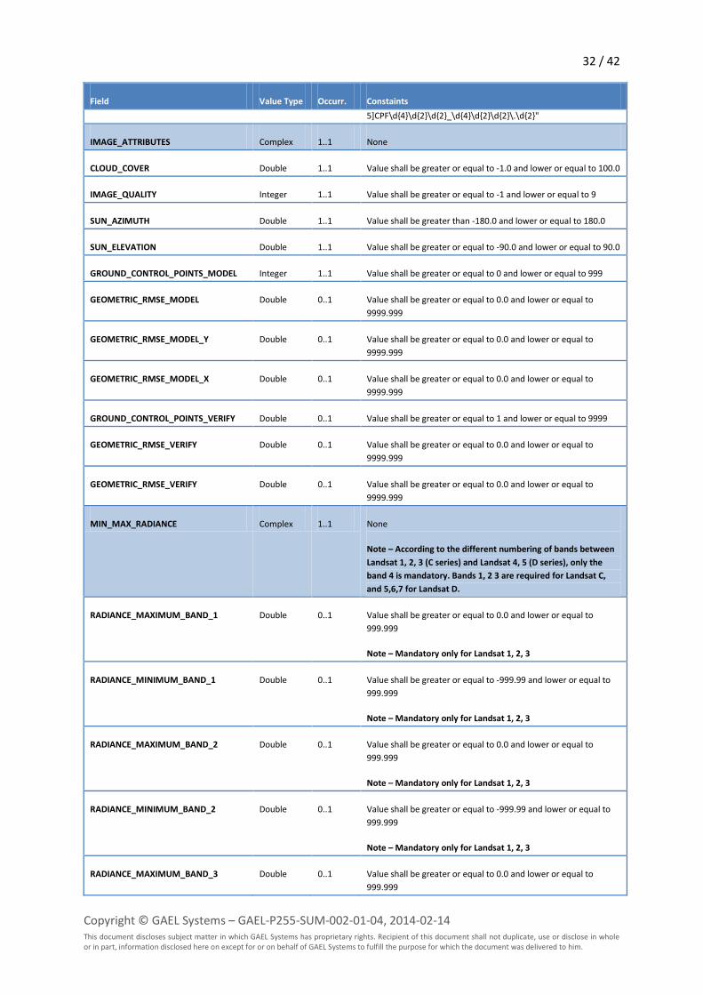
32 / 42
Copyright © GAEL Systems – GAEL-P255-SUM-002-01-04, 2014-02-14 This document discloses subject matter in which GAEL Systems has proprietary rights. Recipient of this document shall not duplicate, use or disclose in whole or in part, information disclosed here on except for or on behalf of GAEL Systems to fulfill the purpose for which the document was delivered to him.
Field Value Type Occurr. Constaints
5]CPF\d{4}\d{2}\d{2}_\d{4}\d{2}\d{2}\.\d{2}"
IMAGE_ATTRIBUTES Complex 1..1 None
CLOUD_COVER Double 1..1 Value shall be greater or equal to -1.0 and lower or equal to 100.0
IMAGE_QUALITY Integer 1..1 Value shall be greater or equal to -1 and lower or equal to 9
SUN_AZIMUTH Double 1..1 Value shall be greater than -180.0 and lower or equal to 180.0
SUN_ELEVATION Double 1..1 Value shall be greater or equal to -90.0 and lower or equal to 90.0
GROUND_CONTROL_POINTS_MODEL Integer 1..1 Value shall be greater or equal to 0 and lower or equal to 999
GEOMETRIC_RMSE_MODEL Double 0..1 Value shall be greater or equal to 0.0 and lower or equal to
9999.999
GEOMETRIC_RMSE_MODEL_Y Double 0..1 Value shall be greater or equal to 0.0 and lower or equal to
9999.999
GEOMETRIC_RMSE_MODEL_X Double 0..1 Value shall be greater or equal to 0.0 and lower or equal to
9999.999
GROUND_CONTROL_POINTS_VERIFY Double 0..1 Value shall be greater or equal to 1 and lower or equal to 9999
GEOMETRIC_RMSE_VERIFY Double 0..1 Value shall be greater or equal to 0.0 and lower or equal to
9999.999
GEOMETRIC_RMSE_VERIFY Double 0..1 Value shall be greater or equal to 0.0 and lower or equal to
9999.999
MIN_MAX_RADIANCE Complex 1..1 None
Note – According to the different numbering of bands between
Landsat 1, 2, 3 (C series) and Landsat 4, 5 (D series), only the
band 4 is mandatory. Bands 1, 2 3 are required for Landsat C,
and 5,6,7 for Landsat D.
RADIANCE_MAXIMUM_BAND_1 Double 0..1 Value shall be greater or equal to 0.0 and lower or equal to
999.999
Note – Mandatory only for Landsat 1, 2, 3
RADIANCE_MINIMUM_BAND_1 Double 0..1 Value shall be greater or equal to -999.99 and lower or equal to
999.999
Note – Mandatory only for Landsat 1, 2, 3
RADIANCE_MAXIMUM_BAND_2 Double 0..1 Value shall be greater or equal to 0.0 and lower or equal to
999.999
Note – Mandatory only for Landsat 1, 2, 3
RADIANCE_MINIMUM_BAND_2 Double 0..1 Value shall be greater or equal to -999.99 and lower or equal to
999.999
Note – Mandatory only for Landsat 1, 2, 3
RADIANCE_MAXIMUM_BAND_3 Double 0..1 Value shall be greater or equal to 0.0 and lower or equal to
999.999

33 / 42
Copyright © GAEL Systems – GAEL-P255-SUM-002-01-04, 2014-02-14 This document discloses subject matter in which GAEL Systems has proprietary rights. Recipient of this document shall not duplicate, use or disclose in whole or in part, information disclosed here on except for or on behalf of GAEL Systems to fulfill the purpose for which the document was delivered to him.
Field Value Type Occurr. Constaints
Note – Mandatory only for Landsat 1, 2, 3
RADIANCE_MINIMUM_BAND_3 Double 0..1 Value shall be greater or equal to -999.99 and lower or equal to
999.999
Note – Mandatory only for Landsat 1, 2, 3
RADIANCE_MAXIMUM_BAND_4 Double 1..1 Value shall be greater or equal to 0.0 and lower or equal to
999.999
RADIANCE_MINIMUM_BAND_4 Double 1..1 Value shall be greater or equal to -999.99 and lower or equal to
999.999
RADIANCE_MAXIMUM_BAND_5 Double 0..1 Value shall be greater or equal to 0.0 and lower or equal to
999.999
RADIANCE_MINIMUM_BAND_5 Double 0..1 Value shall be greater or equal to -999.99 and lower or equal to
999.999
Note – Mandatory only for Landsat 4 and 5
RADIANCE_MAXIMUM_BAND_6 Double 0..1 Value shall be greater or equal to 0.0 and lower or equal to
999.999
Note – Mandatory only for Landsat 4 and 5
RADIANCE_MINIMUM_BAND_6 Double 0..1 Value shall be greater or equal to -999.99 and lower or equal to
999.999
Note – Mandatory only for Landsat 4 and 5
RADIANCE_MAXIMUM_BAND_7 Double 0..1 Value shall be greater or equal to 0.0 and lower or equal to
999.999
Note – Mandatory only for Landsat 4 and 5
RADIANCE_MINIMUM_BAND_7 Double 0..1 Value shall be greater or equal to -999.99 and lower or equal to
999.999
Note – Mandatory only for Landsat 4 and 5
MIN_MAX_PIXEL_VALUE Complex 1..1 None
Note – According to the different numbering of bands between
Landsat 1, 2, 3 (C series) and Landsat 4, 5 (D series), only the
band 4 is mandatory. Bands 1, 2 3 are required for Landsat C,
and 5,6,7 for Landsat D.
QUANTIZE_CAL_MAX_BAND_1 Integer 0..1 Value shall be greater or equal to 0 and lower or equal to 255
Note – Mandatory only for Landsat 1, 2, 3
QUANTIZE_CAL_MIN_BAND_1 Integer 0..1 Value shall be greater or equal to 0 and lower or equal to 1
Note – Mandatory only for Landsat 1, 2, 3
QUANTIZE_CAL_MAX_BAND_2 Integer 0..1 Value shall be greater or equal to 0 and lower or equal to 255
Note – Mandatory only for Landsat 1, 2, 3
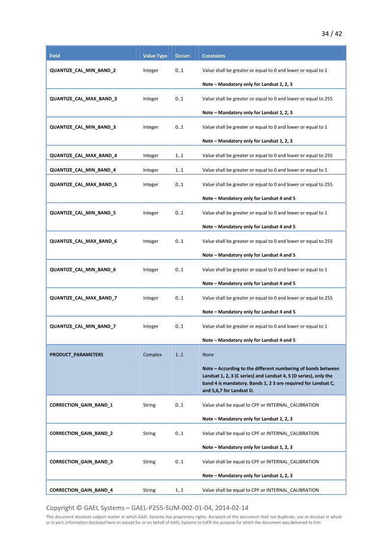
34 / 42
Copyright © GAEL Systems – GAEL-P255-SUM-002-01-04, 2014-02-14 This document discloses subject matter in which GAEL Systems has proprietary rights. Recipient of this document shall not duplicate, use or disclose in whole or in part, information disclosed here on except for or on behalf of GAEL Systems to fulfill the purpose for which the document was delivered to him.
Field Value Type Occurr. Constaints
QUANTIZE_CAL_MIN_BAND_2 Integer 0..1 Value shall be greater or equal to 0 and lower or equal to 1
Note – Mandatory only for Landsat 1, 2, 3
QUANTIZE_CAL_MAX_BAND_3 Integer 0..1 Value shall be greater or equal to 0 and lower or equal to 255
Note – Mandatory only for Landsat 1, 2, 3
QUANTIZE_CAL_MIN_BAND_3 Integer 0..1 Value shall be greater or equal to 0 and lower or equal to 1
Note – Mandatory only for Landsat 1, 2, 3
QUANTIZE_CAL_MAX_BAND_4 Integer 1..1 Value shall be greater or equal to 0 and lower or equal to 255
QUANTIZE_CAL_MIN_BAND_4 Integer 1..1 Value shall be greater or equal to 0 and lower or equal to 1
QUANTIZE_CAL_MAX_BAND_5 Integer 0..1 Value shall be greater or equal to 0 and lower or equal to 255
Note – Mandatory only for Landsat 4 and 5
QUANTIZE_CAL_MIN_BAND_5 Integer 0..1 Value shall be greater or equal to 0 and lower or equal to 1
Note – Mandatory only for Landsat 4 and 5
QUANTIZE_CAL_MAX_BAND_6 Integer 0..1 Value shall be greater or equal to 0 and lower or equal to 255
Note – Mandatory only for Landsat 4 and 5
QUANTIZE_CAL_MIN_BAND_6 Integer 0..1 Value shall be greater or equal to 0 and lower or equal to 1
Note – Mandatory only for Landsat 4 and 5
QUANTIZE_CAL_MAX_BAND_7 Integer 0..1 Value shall be greater or equal to 0 and lower or equal to 255
Note – Mandatory only for Landsat 4 and 5
QUANTIZE_CAL_MIN_BAND_7 Integer 0..1 Value shall be greater or equal to 0 and lower or equal to 1
Note – Mandatory only for Landsat 4 and 5
PRODUCT_PARAMETERS Complex 1..1 None
Note – According to the different numbering of bands between
Landsat 1, 2, 3 (C series) and Landsat 4, 5 (D series), only the
band 4 is mandatory. Bands 1, 2 3 are required for Landsat C,
and 5,6,7 for Landsat D.
CORRECTION_GAIN_BAND_1 String 0..1 Value shall be equal to CPF or INTERNAL_CALIBRATION
Note – Mandatory only for Landsat 1, 2, 3
CORRECTION_GAIN_BAND_2 String 0..1 Value shall be equal to CPF or INTERNAL_CALIBRATION
Note – Mandatory only for Landsat 1, 2, 3
CORRECTION_GAIN_BAND_3 String 0..1 Value shall be equal to CPF or INTERNAL_CALIBRATION
Note – Mandatory only for Landsat 1, 2, 3
CORRECTION_GAIN_BAND_4 String 1..1 Value shall be equal to CPF or INTERNAL_CALIBRATION
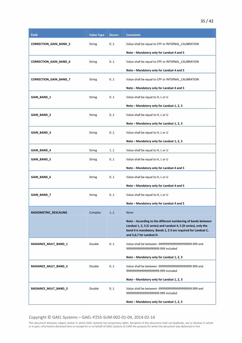
35 / 42
Copyright © GAEL Systems – GAEL-P255-SUM-002-01-04, 2014-02-14 This document discloses subject matter in which GAEL Systems has proprietary rights. Recipient of this document shall not duplicate, use or disclose in whole or in part, information disclosed here on except for or on behalf of GAEL Systems to fulfill the purpose for which the document was delivered to him.
Field Value Type Occurr. Constaints
CORRECTION_GAIN_BAND_5 String 0..1 Value shall be equal to CPF or INTERNAL_CALIBRATION
Note – Mandatory only for Landsat 4 and 5
CORRECTION_GAIN_BAND_6 String 0..1 Value shall be equal to CPF or INTERNAL_CALIBRATION
Note – Mandatory only for Landsat 4 and 5
CORRECTION_GAIN_BAND_7 String 0..1 Value shall be equal to CPF or INTERNAL_CALIBRATION
Note – Mandatory only for Landsat 4 and 5
GAIN_BAND_1 String 0..1 Value shall be equal to H, L or U
Note – Mandatory only for Landsat 1, 2, 3
GAIN_BAND_2 String 0..1 Value shall be equal to H, L or U
Note – Mandatory only for Landsat 1, 2, 3
GAIN_BAND_3 String 0..1 Value shall be equal to H, L or U
Note – Mandatory only for Landsat 1, 2, 3
GAIN_BAND_4 String 1..1 Value shall be equal to H, L or U
GAIN_BAND_5 String 0..1 Value shall be equal to H, L or U
Note – Mandatory only for Landsat 4 and 5
GAIN_BAND_6 String 0..1 Value shall be equal to H, L or U
Note – Mandatory only for Landsat 4 and 5
GAIN_BAND_7 String 0..1 Value shall be equal to H, L or U
Note – Mandatory only for Landsat 4 and 5
RADIOMETRIC_RESCALING Complex 1..1 None
Note – According to the different numbering of bands between
Landsat 1, 2, 3 (C series) and Landsat 4, 5 (D series), only the
band 4 is mandatory. Bands 1, 2 3 are required for Landsat C,
and 5,6,7 for Landsat D.
RADIANCE_MULT_BAND_1 Double 0..1 Value shall be between -99999999999999999999.999 and
99999999999999999999.999 included
Note – Mandatory only for Landsat 1, 2, 3
RADIANCE_MULT_BAND_2 Double 0..1 Value shall be between -99999999999999999999.999 and
99999999999999999999.999 included
Note – Mandatory only for Landsat 1, 2, 3
RADIANCE_MULT_BAND_3 Double 0..1 Value shall be between -99999999999999999999.999 and
99999999999999999999.999 included
Note – Mandatory only for Landsat 1, 2, 3

36 / 42
Copyright © GAEL Systems – GAEL-P255-SUM-002-01-04, 2014-02-14 This document discloses subject matter in which GAEL Systems has proprietary rights. Recipient of this document shall not duplicate, use or disclose in whole or in part, information disclosed here on except for or on behalf of GAEL Systems to fulfill the purpose for which the document was delivered to him.
Field Value Type Occurr. Constaints
RADIANCE_MULT_BAND_4 Double 1..1 Value shall be between -99999999999999999999.999 and
99999999999999999999.999 included
RADIANCE_MULT_BAND_5 Double 0..1 Value shall be between -99999999999999999999.999 and
99999999999999999999.999 included
Note – Mandatory only for Landsat 4 and 5
RADIANCE_MULT_BAND_6 Double 0..1 Value shall be between -99999999999999999999.999 and
99999999999999999999.999 included
Note – Mandatory only for Landsat 4 and 5
RADIANCE_MULT_BAND_7 Double 0..1 Value shall be between -99999999999999999999.999 and
99999999999999999999.999 included
Note – Mandatory only for Landsat 4 and 5
RADIANCE_ADD_BAND_1 Double 0..1 Value shall be between -9999.999 and 9999.999 included
Note – Mandatory only for Landsat 1, 2, 3
RADIANCE_ADD_BAND_2 Double 0..1 Value shall be between -9999.999 and 9999.999 included
Note – Mandatory only for Landsat 1, 2, 3
RADIANCE_ADD_BAND_3 Double 0..1 Value shall be between -9999.999 and 9999.999 included
Note – Mandatory only for Landsat 1, 2, 3
RADIANCE_ADD_BAND_4 Double 1..1 Value shall be between -9999.999 and 9999.999 included
RADIANCE_ADD_BAND_5 Double 0..1 Value shall be between -9999.999 and 9999.999 included
Note – Mandatory only for Landsat 4 and 5
RADIANCE_ADD_BAND_6 Double 0..1 Value shall be between -9999.999 and 9999.999 included
Note – Mandatory only for Landsat 4 and 5
RADIANCE_ADD_BAND_7 Double 0..1 Value shall be between -9999.999 and 9999.999 included
Note – Mandatory only for Landsat 4 and 5
PROJECTION_PARAMETERS Complex 1..1 None
MAP_PROJECTION String 1..1 Value shall be equal to PS or UTM
DATUM String 1..1 Value shall be equal to WGS84
ELLIPSOID String 1..1 Value shall be equal to WGS84
UTM_ZONE Integer 1..1 Value shall be between -60 and 60 included
VERTICAL_LON_FROM_POLE Double 0..1 Value shall be between -180.0 and 180.0 included
TRUE_SCALE_LAT Double 0..1 Value shall be between -90.0 and 90.0 included
FALSE_EASTING Double 0..1 Value shall be between -200000000.0 and 200000000 included
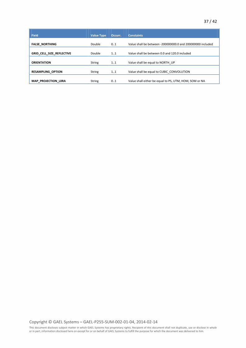
37 / 42
Copyright © GAEL Systems – GAEL-P255-SUM-002-01-04, 2014-02-14 This document discloses subject matter in which GAEL Systems has proprietary rights. Recipient of this document shall not duplicate, use or disclose in whole or in part, information disclosed here on except for or on behalf of GAEL Systems to fulfill the purpose for which the document was delivered to him.
Field Value Type Occurr. Constaints
FALSE_NORTHING Double 0..1 Value shall be between -200000000.0 and 200000000 included
GRID_CELL_SIZE_REFLECTIVE Double 1..1 Value shall be between 0.0 and 120.0 included
ORIENTATION String 1..1 Value shall be equal to NORTH_UP
RESAMPLING_OPTION String 1..1 Value shall be equal to CUBIC_CONVOLUTION
MAP_PROJECTION_L0RA String 0..1 Value shall either be equal to PS, UTM, HOM, SOM or NA
38 / 42
Copyright © GAEL Systems – GAEL-P255-SUM-002-01-04, 2014-02-14 This document discloses subject matter in which GAEL Systems has proprietary rights. Recipient of this document shall not duplicate, use or disclose in whole or in part, information disclosed here on except for or on behalf of GAEL Systems to fulfill the purpose for which the document was delivered to him.
Appendix – System Requirements
This add-on requires an Amalfi instance and therefore inherit from the system requirements of this
latter.
System Requirements
Operating Systems: all supporting Java 6
CPU: equivalent to 500 MHz Pentium 3 or higher speed
System Memory (RAM): 512 Mb free minimum, 1024 Mb or greater free RAM recommended for extensive use
Screen: 1024x768, "16 bit High Color" screen
Network: required only for deployed installations, 128 Kbits/s recommended
Because all components of the Amalfi software are based on Java™, the supported Operating
Systems are those required for installing a Java™ Virtual Machine. For up to date information,
report to the following Web page: http://www.oracle.com/technetwork/java/javase/system-
configurations-135212.html
Software Requirements
This add-on requires an installed Amalfi v2.0.5 already installed on the target system.

39 / 42
Copyright © GAEL Systems – GAEL-P255-SUM-002-01-04, 2014-02-14 This document discloses subject matter in which GAEL Systems has proprietary rights. Recipient of this document shall not duplicate, use or disclose in whole or in part, information disclosed here on except for or on behalf of GAEL Systems to fulfill the purpose for which the document was delivered to him.
Acronyms and Abbreviations
ASCII American Standard Code for Information Interchange
CCSDS Consultative Committee for Space Data Systems
DOM Document Object Model
DRB Data Request Broker
EBV Effective Boolean Value
FTP File Transfer Protocol
ISO International Organization for Standardization
JAR Java ARchive
OWL Web Ontology Language
POM Project Object Model
RDF Resource Description Framework
RPM RedHat Package Manager
SDF Structured Data File
TAR Tape ARchive
W3C World Wide Web Consortium
XML eXtensible Markup Language
XSD XML Schema Description
ZIP Compression format

40 / 42
Copyright © GAEL Systems – GAEL-P255-SUM-002-01-04, 2014-02-14 This document discloses subject matter in which GAEL Systems has proprietary rights. Recipient of this document shall not duplicate, use or disclose in whole or in part, information disclosed here on except for or on behalf of GAEL Systems to fulfill the purpose for which the document was delivered to him.
Glossary of Terms
add-on Amalfi package containing the entire configuration to perform dataset inspection.
Data A reinterpretable representation of information in a formalized manner suitable for communication, interpretation, or processing. Examples of data include a sequence of bits, a table of numbers, the characters on a page, the recording of sounds made by a person speaking, or a moon rock specimen – [CCSDS-OAIS].
DRB Cortex Extension DRB Cortex is an extension to DRB able to provide semantic information inside DRB items.
Format Format is a way of encoding data in a file.
Inspection Conformity evaluation by observation and judgment accompanied as appropriate by measurement, testing or gauging – [ISO 9000:2000].
Item (DRB scope) Item in DRB is the most abstract element managed by DRB. Existing implementations of items is Node, Value or Attribute.
Ontology Ontology is usually shown as a graph defining relationship between simple element, and given semantic to.
Ontology Model The model above an ontology. DRB Cortex API uses RDF/OWL model to provides semantics to DRB items.
Quality Control Part of quality management focused on fulfilling quality requirements – [ISO 9000:2000]
Physical Object An object (such as a moon rock, bio-specimen, microscope slide) with physically observable properties that represent information that is considered suitable for being adequately documented for preservation, distribution, and independent usage – [CCSDS-OAIS]
Reporting Returning a formatted set of results.
Representation Information The information that maps a Data Object into more meaningful concepts. An example is the ASCII definition that describes how a sequence of bits (i.e., a Data Object) is mapped into a symbol - [CCSDS-OAIS]
Result Persistency A way of keeping result. (database, mail ...)
Structure Information The information that imparts meaning about how other information is organized. For example, it maps bit streams to common computer types such as characters, numbers, and pixels and aggregations of those types such as character strings and arrays – [CCSDS-OAIS]
Topic DRB package containing configuration able to decode dataset.

41 / 42
Copyright © GAEL Systems – GAEL-P255-SUM-002-01-04, 2014-02-14 This document discloses subject matter in which GAEL Systems has proprietary rights. Recipient of this document shall not duplicate, use or disclose in whole or in part, information disclosed here on except for or on behalf of GAEL Systems to fulfill the purpose for which the document was delivered to him.
Bibliography
[AMALFI-SUM] Amalfi 2.1 – User Manual. GAEL-P255-SUM-001. Version 3.4. March 1, 2013.
GAEL Systems.
[LS-DFCB-04] Landsat 7 (L7) – Enhanced Thematic Mapper Plus (ETM+) – Level 1 (L1). Data
format Control Book (DFCB). Version 15.0. September 2012. Department of
the Interior. U.S. Geological Survey (USGS).
[LS-DFCB-20] Landsat Thematic Mapper (TM) – Level 1 (L1). Data format Control Book
(DFCB). Version 4.0. August 2012. Department of the Interior. U.S. Geological
Survey (USGS).
[LS-DFCB-22] Landsat Multispectral Scanner (MSS) – Level 1 (L1). Data format Control Book
(DFCB). Version 3.0. August 2012. Department of the Interior. U.S. Geological
Survey (USGS).
[ISO 9000:2000] Quality management systems. Fundamentals and vocabulary. ISO Standard.
September 20, 2005. Revision 2. Copyright © 2005 International Organization
for Standardization (ISO).
[OWL] OWL Web Ontology Language: Reference. W3C Recommendation. February
10, 2004. Version 1.0. Copyright © 2004 World Wide Web Consortium (W3C).
[RDF] RDF/XML Syntax Specification (Revised). W3C Recommendation. February 10,
2004. Version 1.0. Copyright © 2004 World Wide Web Consortium (W3C).
[XML] eXtensible Markup Language (XML) 1.0 (Second Edition). W3C
Recommendation. October 6, 2000. Version 1.0. Copyright © 2000 World
Wide Web Consortium (W3C).
[XML-SCHEMA] XML Schema: Primer. W3C Recommendation. May 2, 2001. Version 1.0.
Copyright © 2001 World Wide Web Consortium (W3C).
[XML-SCHEMA-STRUCT] XML Schema: Structures. W3C Recommendation. May 2, 2001. Version 1.0.
Copyright © 2001 World Wide Web Consortium (W3C).
[XML-SCHEMA-TYPES] XML Schema: Data Types. W3C Recommendation. May 2, 2001. Version 1.0.
Copyright © 2001 World Wide Web Consortium (W3C).
[XQUERY] XQuery 1.0: An XML Query Language. W3C Recommendation. January 23,
2007. Version 1.0. Copyright © 2007 World Wide Web Consortium (W3C).
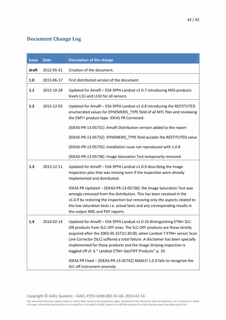
42 / 42
Copyright © GAEL Systems – GAEL-P255-SUM-002-01-04, 2014-02-14 This document discloses subject matter in which GAEL Systems has proprietary rights. Recipient of this document shall not duplicate, use or disclose in whole or in part, information disclosed here on except for or on behalf of GAEL Systems to fulfill the purpose for which the document was delivered to him.
Document Change Log
Issue Date Description of the change
draft 2012-05-31 Creation of the document.
1.0 2013-06-17 First distributed version of the document
1.1 2013-10-28 Updated for Amalfi – ESA SPPA Landsat v1.0.7 introducing MSS products
levels L1G and L1Gt for all sensors
1.2 2013-12-03 Updated for Amalfi – ESA SPPA Landsat v1.0.8 introducing the RESTITUTED
enumerated values for EPHEMERIS_TYPE field of all MTL files and reviewing
the EMT+ product type. IDEAS PR Corrected:
[IDEAS-PR-13-05731]: Amalfi Distribution version added to the report
[IDEAS-PR-13-05732]: EPHEMERIS_TYPE field accepts the RESTITUTED value
[IDEAS-PR-13-05735]: Installation issue not reproduced with 1.0.8
[IDEAS-PR-13-05736]: Image Saturation Test temporarily removed
1.3 2013-12-11 Updated for Amalfi – ESA SPPA Landsat v1.0.9 describing the Image
Inspection plan that was missing even if the inspection were already
implemented and distributed.
IDEAS PR Updated – [IDEAS-PR-13-05736]: the Image Saturation Test was
wrongly removed from the distribution. This has been resolved in the
v1.0.9 by restoring the inspection but removing only the aspects related to
the low saturation tests i.e. actual tests and any corresponding results in
the output XML and PDF reports.
1.4 2014-02-14 Updated for Amalfi – ESA SPPA Landsat v1.0.10 distinguishing ETM+ SLC-
ON products from SLC-OFF ones. The SLC-OFF products are those strictly
acquired after the 2003-05-31T21:30:00, when Landsat 7 ETM+ sensor Scan
Line Corrector (SLC) suffered a total failure. A disclaimer has been specially
implemented for those products and the Image Striping inspection is
toggled off cf. § “ Landsat ETM+ GeoTIFF Products” p. 19.
IDEAS PR Fixed – [IDEAS-PR-13-05742] AMALFI 1.0.9 fails to recognize the
SLC off instrument anomaly.


