An Agenda for Information Theory Research in Sensor Networks Outline • Introduction • The Conventional Paradigm • The Emerging Paradigm • New Theory Challenges Greg Pottie UCLA EE Department Center for Embedded Networked Sensing [email protected]
Transcript
An Agenda for Information Theory Research in Sensor Networks
Outline
• Introduction• The Conventional Paradigm• The Emerging Paradigm• New Theory Challenges
• Much research has focused upon sensor networks with some alternative assumption sets:– Memory, processing, and sensing will be cheap, but
communications will be dear; thus in deploying large numbers of sensors concentrate on algorithms that limit communications but allow large numbers of nodes
– For the sensors to be cheap, even the processing should be limited; thus in deploying even larger numbers of sensors concentrate on algorithms that limit both processing and communications
• In either case, compelling theory can be constructed for random deployments with large numbers and flat architectures
Theory for Dense Flat Networks of Simple Nodes
• Redundant communications pathways given unreliable radios
• Data aggregation and distributed fusion– Combinations with routing, connections with network rate distortion
• Early research concentrated on short-term military deployments– Can imagine that leaving batteries everywhere is at least as
acceptable as leaving depleted uranium bullets; careful placement/removal might expose personnel to danger
– Detection of vehicles (and even ID of type) and detection of personnel can be accomplished with relatively inexpensive sensors that don’t need re-calibration or programming in the field
• Story was plausible…
But was this ever done?
• Military surveillance– Largest deployment (1000 nodes or so) was in fact hierarchical and
required careful placement; major issues with radio propagation even on flat terrain
– Vehicles are really easy to detect with aerial assets, and the major problem with personnel is establishment of intent; this requires a sequence of images
– Our major problems are not battles, but insurgencies, which demand much longer-term monitoring as well as concealment
• Science applications diverge even more in basic requirements– Scientists want to know precisely where things are; cannot leave
heavy metals behind; many other issues
• Will still want dense networks of simple nodes in some locations, but will be system component
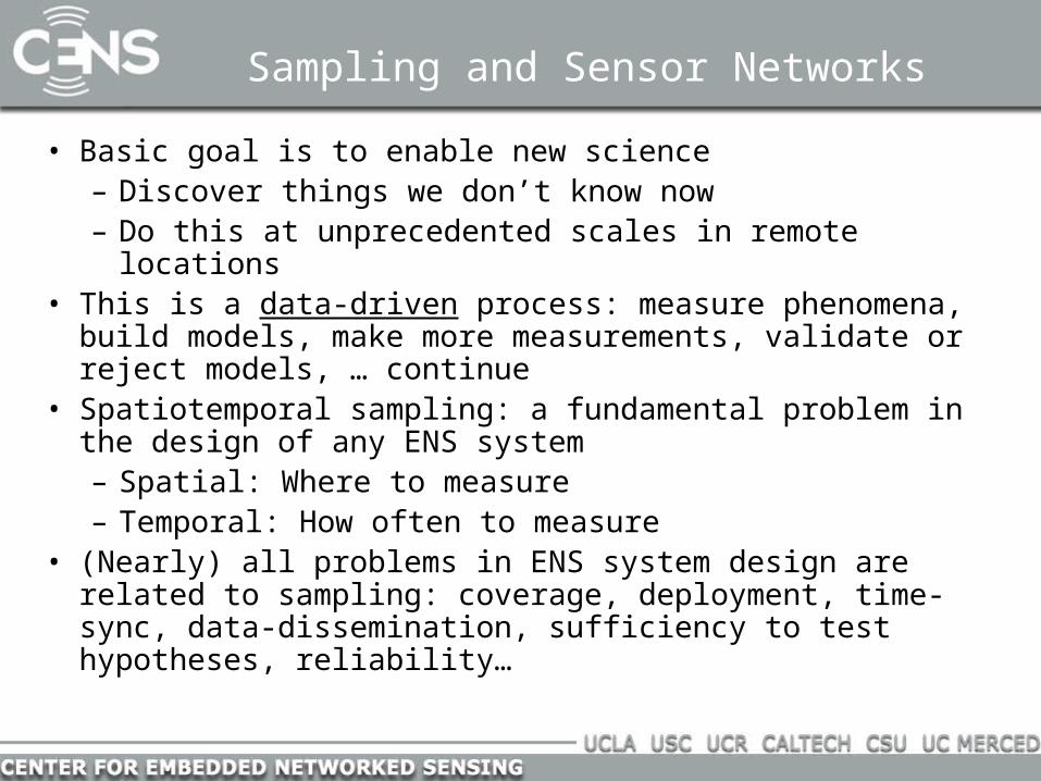
Sampling and Sensor Networks
• Basic goal is to enable new science– Discover things we don’t know now– Do this at unprecedented scales in remote locations
• This is a data-driven process: measure phenomena, build models, make more measurements, validate or reject models, … continue
• Spatiotemporal sampling: a fundamental problem in the design of any ENS system– Spatial: Where to measure– Temporal: How often to measure
• (Nearly) all problems in ENS system design are related to sampling: coverage, deployment, time-sync, data-dissemination, sufficiency to test hypotheses, reliability…
Adaptive Sampling Strategies
• Over-deploy: focus on scheduling which nodes are on at a given time
• Actuate: work with smaller node densities, but allow nodes to move to respond to environmental dynamics
• Our apps are at large scales and highly dynamic: over-deployment not an option– Always undersampled with respect to some
phenomenon– Focus on infrastructure supported mobility– Passive supports (tethers, buoyancy)– Small number of moving nodes
• Will need to extend the limited sets of measurements with models
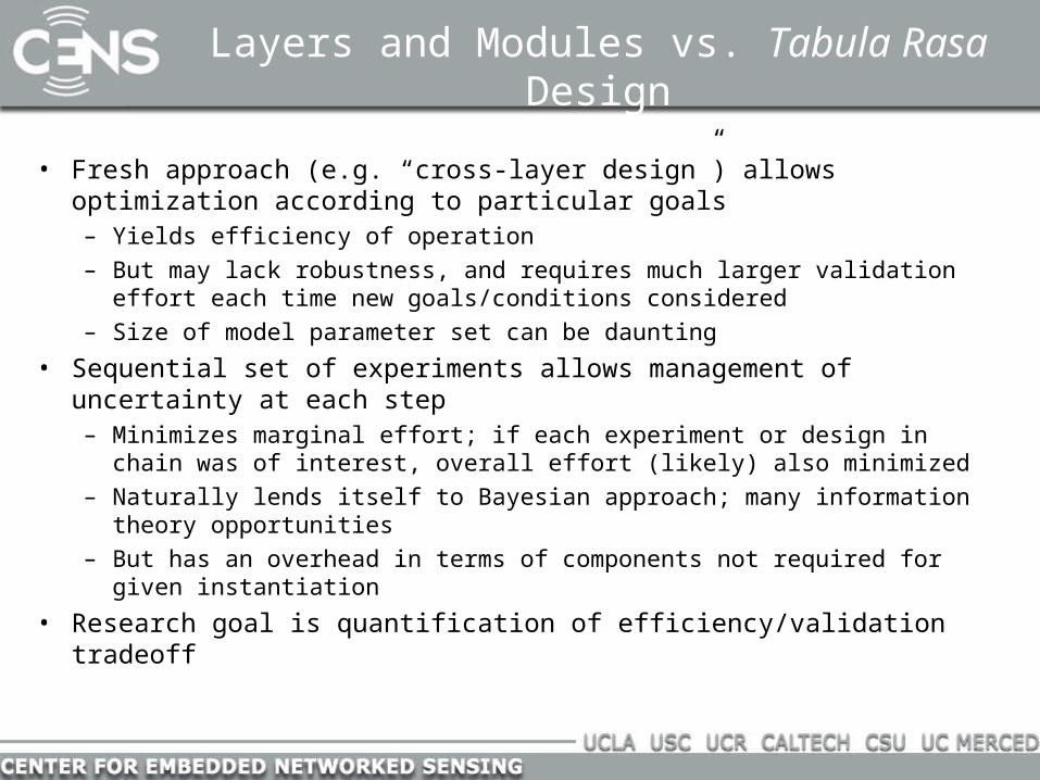
Evolution to More Intelligent Design
• Early sensor network research focused on resource constrained nodes and flat architecture– High density deployments with limited application set
• Many problems with this flat architecture– Software is nightmarish– Always undersample physical world in some respect– Logistics are very difficult; usually must carefully place, service,
and remove nodes
• The major constraint in sustained science observations is the sensor– Biofouling/calibration: must service the nodes
• Drives us towards tiered architecture that includes mobile nodes– Many new and exciting theory problems
Some Theory Problems
• Data Integrity– Sufficiency of network components/measurements to trust
results
• Model Uncertainty– Effects on deployment density, number of measurements
needed given uncertainty at different levels
• Multi-scale sensing– Information flows between levels; appropriate populations at
the different levels given sensing tasks– Local interactions assume increased importance
• Logistics management– Energy mules– Mobile/fixed node trades
Many Models
• Source Phenomena– Discrete sets vs. continuous, coupling to medium,
propagation medium, noise and interference processes
• Sensor Transduction– Coupling to medium, conversion to electrical signal, drift and
error sources
• Processing Abstractions– Transformation to reduced representations, fusion among
diverse sensor types
• System Performance– Reliability of components, time to store/transport data at
different levels of abstraction
Much Uncertainty
• Observations (Data)– Noisy, subject to imperfections of signal conversion,
interference, etc.
• Model Parameters– Weighting of statistical and deterministic components;
selection of model order
• Models– Particular probability density function family, differential
equation set, or in general combination of components
• Goals and System Interactions– Goals can shift with time, interactions with larger system not
always well-defined
Model and Data Uncertainty in Sensor Networks
• How much information is required to trust either data or a model?
• Approach: multi-level network and corresponding models; evaluation of sequence of observations/experiments
Multiple nodes observe source, exchangereputation information, and then interactwith mobile audit node
Data Uncertainty
How many nodes must sample a field to determine it is caused by one (or more) point sources?
Model Uncertainty
A Few Problems
• Validation (=debugging) is usually very painful– One part design, 1000 parts testing– Never exhaustively test with the most reliable method
• So how can we trust the result given all the uncertainties?– Not completely, so the design process deliberately minimizes the
uncertainties through re-use of trusted components
• But is the resulting modular model/design efficient?– Fortunately not for academics; one can always propose a more
efficient but untestable design
• Our goal: quantifying this efficiency vs. validation effort tradeoff in model creation for environmental applications
Universal Design Procedure
• Innovate as little as possible to achieve goals– Applies to surprisingly large number of domains of human
activity.
• Begin with what we know– E.g., trusted reference experiment, prior model(s)
• Validate a more efficient procedure– Exploit prior knowledge to test selected cases
• Bake-off the rival designs or hypotheses– Use your favorite measure of fitness
• Iterate– Result is usually a composite model with many components
Example: Radio Propagation
• Model from First Principles: Maxwell’s Equations– Complete description (until we get to the scale of quantum dynamics)
– Economy of principles
– Computationally intractable for large volumes
– Many parameters that must be empirically determined