PROCEEDINGS 11 TH INTERNATIONAL RESEARCH CONFERENCE 70 GENERAL SIR JOHN KOTELAWALA DEFENCE UNIVERSITY PROOF AN ANALYSIS OF LAND USE SUITABILITY OF A SELECTED ZONE IN WATTALA LOCAL AREA PLAN WDDP Withanage 1 , CP Ranawaka 2 1, 2 Department of Spatial Sciences, Faculty of Built Environment and Spatial Sciences, General Sir John Kotelawala Defence University, Sri Lanka 1 [email protected]Abstract - e Development Plan of an area is a main legal document that is prepared for development of that area, integrating Social, Economic, Physical and Environmental aspects with the views of stakeholders in addition to general public and Local Authority. Zoning is one of the tools used to control land use change on plots and it is defined based on existing potentials and possible impacts due to the rapid urbanization with the agglomeration of various economic activities which may take place in the area in future. is study area is confined to Handala Grama Niladhari Division which is identified as “Moderate Residential Zone” in Wattala Development Plan that encompasses Wattala Urban Council area which is still in draſt level. rough this development plan, it is expected to create a sustainable development with the prime objective of upliſting the living standards of people living in the area by improving efficient environment for the residing people and preparation of strategies. Aim of this study is to carry out suitability analysis of existing land uses in the selected area, to find out incompatible land uses and why it has taken place in an area within the development plan. Finally, this research analyses to what extent this Development Plan is effective for harnessing existing potentials and how far it can regulate the land use activities. is study reveals that 79% of the area is used for Residential or Commercial activities. 19 % of the area is consisted with water and marshy lands. 12.5% of the area has been neglected as barren or Waste lands. It is highlighted that development plan prepared for such a rapidly developing area is still being at draſt level and is hindering the effectiveness of the enforcement of new planning regulation. Keywords: Development Plan, Zoning, Land use, planning Regulation I. INTRODUCTION Sri Lanka is a developing country with annual increase in population at a highly considerable rate (Sampath Pathikada, 2012), especially in the urban areas. Systematic town planning could ideally be the deciding factor of what a town should be like before it is built to fulfil the needs of its people. While some local areas show the urban characteristics, some urban directly show the developing characteristics like rural characteristics. erefore, we are not able to define a clear margin for rural areas and urban areas. e urban areas could be defined according to the following common factors. ➢ Administrative boundaries (Municipal Council, Urban Council) ➢ Declare areas under the Urban Development Authority (UDA) ➢ Population Density ➢ Land Use Pattern (Commercial, Industrial uses, primary residential and mixed residential) ➢ Available Infrastructure (Water, Electricity, Road, Sewerage…etc. Based on the above control parameters or any other means, urban development is the improvement of existing facilities to achieve the maximum benefits to upgrade living standards of residents. Analysing land use pattern is important to spatial planners. As a professional in surveying, who are engaging with land
Transcript
PROCEEDINGS
11TH INTERNATIONAL RESEARCH CONFERENCE70 GENERAL SIR JOHN KOTELAWALA DEFENCE UNIVERSITY
PROOF
AN ANALYSIS OF LAND USE SUITABILITY OF A SELECTED ZONE IN
WATTALA LOCAL AREA PLAN WDDP Withanage1, CP Ranawaka2
1, 2 Department of Spatial Sciences, Faculty of Built Environment and Spatial Sciences, General Sir John Kotelawala Defence University, Sri Lanka
Abstract - The Development Plan of an area is a main legal document that is prepared for development of that area, integrating Social, Economic, Physical and Environmental aspects with the views of stakeholders in addition to general public and Local Authority. Zoning is one of the tools used to control land use change on plots and it is defined based on existing potentials and possible impacts due to the rapid urbanization with the agglomeration of various economic activities which may take place in the area in future. This study area is confined to Handala Grama Niladhari Division which is identified as “Moderate Residential Zone” in Wattala Development Plan that encompasses Wattala Urban Council area which is still in draft level. Through this development plan, it is expected to create a sustainable development with the prime objective of uplifting the living standards of people living in the area by improving efficient environment for the residing people and preparation of strategies.
Aim of this study is to carry out suitability analysis of existing land uses in the selected area, to find out incompatible land uses and why it has taken place in an area within the development plan. Finally, this research analyses to what extent this Development Plan is effective for harnessing existing potentials and how far it can regulate the land use activities. This study reveals that 79% of the area is used for Residential or Commercial activities. 19 % of the area is consisted with water and marshy lands. 12.5% of the area has been neglected as barren or Waste lands. It is highlighted that development plan prepared for such a rapidly developing area is still being at draft level and is hindering the effectiveness of the enforcement of new planning regulation.
Keywords: Development Plan, Zoning, Land use, planning Regulation
I. INTRODUCTION
Sri Lanka is a developing country with annual increase in population at a highly considerable rate (Sampath Pathikada, 2012), especially in the urban areas. Systematic town planning could ideally be the deciding factor of what a town should be like before it is built to fulfil the needs of its people. While some local areas show the urban characteristics, some urban directly show the developing characteristics like rural characteristics. Therefore, we are not able to define a clear margin for rural areas and urban areas. The urban areas could be defined according to the following common factors.
➢ Declare areas under the Urban Development Authority (UDA)
➢ Population Density
➢ Land Use Pattern (Commercial, Industrial uses, primary residential and mixed residential)
➢ Available Infrastructure (Water, Electricity, Road, Sewerage…etc.
Based on the above control parameters or any other means, urban development is the improvement of existing facilities to achieve the maximum benefits to upgrade living standards of residents.
Analysing land use pattern is important to spatial planners. As a professional in surveying, who are engaging with land
PROCEEDINGS
11TH INTERNATIONAL RESEARCH CONFERENCE 71GENERAL SIR JOHN KOTELAWALA DEFENCE UNIVERSITY
PROOF
sub divisions process and allied works like various maps preparing, understanding how \ land use changes become evident with the physical development and the fact that land use changes are the everlasting process that may lead to more and more land fragmentation are more important for efficiency of the planning process. Understanding planning requirements according to the national, regional and especially local area planning will be helpful to expedite cumbersome planning approval process and minimize gap between planning professionals and survey professionals.
For this study, Wattala UDA area in Gampaha district has been selected as a case study area. Due to the population distribution and agglomeration of economic activities of the area, there is a huge demand on lands for residential, industrial and commercial purposes. UDA is regulating existing development for minimizing those incompatible land uses while improving quality of life of the residents and efficiency of the environment. It is important to analyse the human impact on land use changes in an area since this phenomenon is happening in whole urban areas in the country, affecting locally, within immediate regions and ultimately to the whole country.
This research mainly analyses the gap between present possible land use changes taking place in the area and expected land use changes according to the “Development Plan” which is being implemented. Thus, an analysis is carried out to find to what extent this Development Plan is effective for harnessing existing potentials and how far to regulate the land use activities in the area. In Wattala UDA area there are 46 Grama Niladhari divisions which enforce different regulations according to the existing development plan, promoting compatible land use activities while discouraging and/or prohibiting incompatible land uses such as residential, commercial, industrial uses, primary residential, mixed development, tourism, industrial etc.
This research focuses on “one selected zone” in Wattala area, existing land uses in that area in consequence with the prevailing development. Then it analyses the present land use changes within the zone and the driving forces for the land use changes taken place within the selected zone.In order to analyse changes in land uses pattern, below factors will be studied as main driving factors of human activities.
01) Population Density02) Existing Road Network03) Main Industries04) Institutions (Schools/Courts/Government Offices)05) Geography06) Infill Migration
According to the livelihood engaged, expected quality of the life and image of the city, people tend to select an area to build their own houses. People those who can’t afford such a land, are settled within the urban fringe either marshy land or low laying areas only for accessing infrastructure facilities (Land use data, 2012). When this process happens continuously, area can be subjected to natural disasters like flash floods and sanitary issues that lead to health issues within the community who are living in those areas. Highly sensitive wetlands like Muturajawela which is situated close-proximity of the area will get affected by illegal constructions. This negative impact can affect the endangered species in those areas. As a result some native organisms face a threat of extinction. This situation will directly affect the Environmental Sustainability. I. LITERATURE REVIEWA. Applying Zoning Regulations Internationally
Zoning for sustainability- this research tells how communities comply with zoning regulations to achieve their goals in sustainable manner and how to understand zoning plan regulated by the development plan. The study approach is in four phases. In the first phase a sample of the zoning plan is selected to evaluate. In the second phase, items that may be present in a zoning plan are identified to implement sustainability principles. The third phase determines if the regulatory items identified are presented in our sample of zoning plan and measures the extent to which sustainability has been included in zoning. The final phase reviews selected regulatory items which are considered to be important and which appear only rarely in the zoning plan. (Zoning for Sustainability, 2014) “Effectiveness of the Development Control System for the city of Colombo, Sri Lanka” -In this research paper, researcher analyses the regulations that specify the standards related to lot sizes, width of the access, parking requirements, reservations for open space and building densities. They are divided into nine land use zones, such as, primary residential, mixed Residential, commercial, General industrial, special industrial, Public and Semi-public, parks, play grounds and open space and agricultural
PROCEEDINGS
11TH INTERNATIONAL RESEARCH CONFERENCE72 GENERAL SIR JOHN KOTELAWALA DEFENCE UNIVERSITY
PROOF
and Deferred Zones. Researcher says if development control is to be effective the standards stipulated in the regulations must be in accordance with the social, economic and environmental context of the particular city concerned. (Effectiveness of the Development Control System for the City of Colombo, Sri Lanka, 1987)
B. What are the good practices in Zoning?
Zoning and urban planning -In this research researcher declares the good planning practices in zoning. Many economies require the obtaining of a construction permit. This has been done to ensure the intended building located in the appropriate zone (industrial, commercial, residential) according to the city’s zoning requirements. Some city authorities have completed the process efficiently and effectively by making zoning maps of cities accessible to builders, and then they can include the information in the building permit applications. In other economies the permits-issuing authority checks the zoning compliance after receiving the building permit applications. (Zoning and urban planning, 2015) and this research declares the sustainable principals, such as, encourage the higher density development, encourage mixed use, encourage local food production, protect ecosystem and natural functions, encourage transportation alternatives, preserve/ create a sense of place, increase housing diversity and affordability. (Zoning for Sustainability, 2014)
C. Identify land use changes “Monitoring Land Use Change in Rural Sri Lanka from Sequential Aerial Photography” -Researcher uses number of methods to illustrate changing patterns of Urban Land Use. The researcher uses black and white panchromatic photography supplemented by Field checks. Preliminary air photointerpretation stereoscopic pairs of photographs were used to improve the accuracy of interpretation and assessment of agricultural land and water and resources. In 1956 air photos (scale 1: 40,000) and in 1982 air photos (Scale 1: 20,000) were used in this research. (monitoring land use change in rural Sri Lanka from sequential aerial photography, 1983) In “Spatial and Temporal Changes of the Green Cover of Colombo City in Sri Lanka from 1956 to 2010”- Satellite images were not available for research during the years from 1956 to 1982. Therefore, Aerial Photographs of 1: 20,000 scale were used during that period. High Resolution IKONS images (4m spatial resolution) were used from 2001 to 2010. They were georeferenced two IKONS images, and they were digitized by “on screen Digitizing” method using Arc GIS 9.3
software. The rate of green cover change was estimated by calculating the green cover change during each period and then dividing it by number of years consisted in that particular period. (Spatial and Temporal Changes of the Green Cover of Colombo City in Sri Lanka from 1956 to 2010, 2016) “Detection of Land Use Changes through GIS Functionality a Case Study in Randenigala and Kotmale Sub catchments” - Research used workstation Arc/Info version 7.12 as the GIS software. In addition, TIN module and Grid module of Arc/Info software were used to delineate catchment boundaries, and used map generalized procedure. However, it is not realistic due to the errors uncontended in process and time taken for such a process which was very high. In research digital land use map of 1956 and land use map of 1992 were reclassified into a unified legend. (Detection of Land Use Changes Through GIS Functionality: A Case Study in Randenigala and Kotmale Sub catchments, 2000)
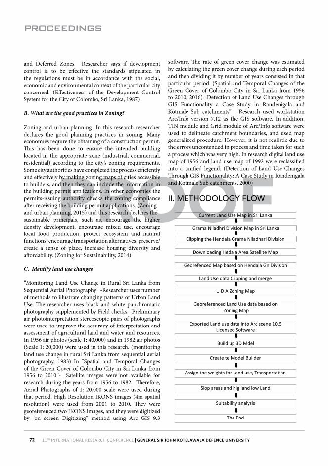
II. METHODOLOGY FLOW
Build up 3D Mdel
Current Land Use Map in Sri Lanka
Grama Niladhri Division Map in Sri Lanka
Clipping the Hendala Grama Niladhari Division
Downloading Hedala Area Satellite Map
Georefenced Map based on Hendala Gn Division
Land Use data Clipping and merge
U D A Zoning Map
Georeferenced Land Use data based on Zoning Map
Create te Model Builder
Assign the weights for Land use, Transportation
Slop areas and hig land low Land
Suitability analysis
The End
Exported Land use data into Arc scene 10.5 Licensed Software
PROCEEDINGS
11TH INTERNATIONAL RESEARCH CONFERENCE 73GENERAL SIR JOHN KOTELAWALA DEFENCE UNIVERSITY
PROOF
III. DATA COLLECTIONA. Primary data collection
The primary data collection was done by the questionnaires as well as by personal observations and interviewing the Executive persons, and the Data was generated by one Divisional Secretariat in Wattala. In this area there are 46 Grama Niladhari Divisions. Data was collected from those sample households through referring to past 10 years Documents.
B. Secondary data collection
The secondary Data was collected from the published and unpublished sources in Urban Development Authority and Survey Department. Published Sources are available at the Survey Department. Land use information and the zoning regulations related to the Hendala area ware obtained by Urban Development Authority, District office, Gampaha. Unpublished information is in the Wattala Zoning Map.
IV. DATA ANALYSING
Data analysis was done using the GIS 10.5 Licensed Software. Current land use map prepared by Survey Department, few satellite images taken in past 10 years of the Area and shape file of Hendala Grama Niladhari Division were used for analysis. Using clip function, the GN Division Map was extracted. Thereafter satellite Maps were Georeferenced based on the said Hendala GN Division Map. Land use Data were merged and clipped based on the GN Division Map. Zoning map prepared by UDA was used for georeferenced land use data and past satellite maps were georeferenced based on the Zoning map in the Area. It enables to identify what zoning regulations apply to this area (moderate Density Residential Zone).
V. RESULT AND DISCUSSION
All the details are exported to the Arc Scene 10.5 and formed 3D model. The possible changes in area, present land use changes taking place in the area and expected land use changes according to the development plan can be identified through this analysis. Finally Suitability analysis was done using ArcGIS Licensed software. Possible changes of land use area.
Barren land
Scrub land
Marshy Land
Garden Area
PROCEEDINGS
11TH INTERNATIONAL RESEARCH CONFERENCE74 GENERAL SIR JOHN KOTELAWALA DEFENCE UNIVERSITY
PROOF
Waste Land
Water Areas
Commercial Buildings
Factory Building
Other Government Buildings
Model Builder
PROCEEDINGS
11TH INTERNATIONAL RESEARCH CONFERENCE 75GENERAL SIR JOHN KOTELAWALA DEFENCE UNIVERSITY
PROOF
Suitability for Slope Area
Suitability of Topography
Weighted allocated for suitability analysis
Suitability for Transport
Raster Influence field Scalevalue
Transport 40% 0 - 50m 7
50 -100m 9
100 - 200m 5
200 - 555m 3
Slope 10% 0.001106- 1m 8
2 - 8.75846m 8
Land use 40% HOMSA 7
All Water 1
Marsh Land Restricted
Barren Land 8
Hydro Area Restricted
Waste Land 3
Coconut Land 3
Scrub Land 6
PROCEEDINGS
11TH INTERNATIONAL RESEARCH CONFERENCE76 GENERAL SIR JOHN KOTELAWALA DEFENCE UNIVERSITY
PROOF
Suitability analysis for Hendala Area
In this division have many kind of land uses, such as, garden areas, all water areas, marshy land, barren land, waste land, coconut land and scrub land.
Garden area – 79.0960%All water area- 9.6011%Marshy land- 9.6011%Barren Land-7.8739%Waste Land- 0.33745%Coconut land- 0.0218%Scrub land- 0.8053%hydra – 1.727%
VI. CONCLUSION
When considering the suitability analysis, we can review this zone how to regulate so far. This zone is allocated for ‘Moderate density residential zone’. Hendala Grama Niladharie division is in this zone. This division has many kind of land uses, such as, garden areas, all water areas, marshy land, barren land, waste land, coconut land and scrub land.
In this situation we can identify how to regulate the zoning plan in the area. Since the community participation is a major event of the planning process, suggestion and
proposals of the people of the area have been considered by the planning team in the preparation of the development plan of Wattala city and development objectives have been decided as follows.
Improve the Efficiency of the city
➢ Establishment of a systematic vehicle management System.
➢ Separation of mismatching usages of one another through zoning
➢ Improving the efficiency of Roads ➢ Improving the junctions of cities Creating a suitable living environment for the residing
people➢ Introduce the tube water system to the area.➢ Establish infrastructure facilities necessary for the
development of residencies➢ Encourage developers for the development of houses ➢ Introduce a systematic waste management system➢ Introduce a systematic sewer system ➢ Encourage fishery and tourism industries ➢ Establish basic post structural facilities for low-income
people ➢ Introduce community development programs by the
social development committees for the up liftmen of the social status of the people.
➢ Develop environmental facilities.
Preparation of strategies
The following strategies have been identified for the implementation of the development plan of the Wattala city systematically and efficiently.
➢ Implementation of zoning plan
➢ Implementation of planning and building regulations
➢ Implementation of identified active projects
➢ Strengthening the implementation process
According to the suitability analysis shown in the figure (36) 72.4063% can be used for residential area, 81.5070% area can be protected by natural disasters. Furthermore 12.24324% is not good for use residential purposes or any other construction purposes. Therefore these facts prove that the planners’ selection of this area as ‘Moderate Density residential areas’ is correct decision.
PROCEEDINGS
11TH INTERNATIONAL RESEARCH CONFERENCE 77GENERAL SIR JOHN KOTELAWALA DEFENCE UNIVERSITY
PROOF
Acknowledgement
Firstly, I would like to acknowledge the support of Senior Lecture Mr.C.P. Ranawaka, Head of the Department of Spatial Sciences for their supervision and encouragement.I also wish to give my sincere gratitude to Mr. Ranjana Geethalankara, Ms. Chathurnika Samanthilaka, Mrs. Chithrani Abeyakoon, Ms. Minoli Perera, Mr. W.D.C.S Kumarasiri, Mr.J.M.I Karaliadaa, Mr. K.M.D.P Kulathunga, Mr. K.A.I.M Jayathilaka, Ms. C.D Iddagoda and Ms. D.S.N Jayakodi for providing necessary data and their assistance in preparing this report.
References
Kaleel, M. (2018). Land use changes in Kalmunai Municipal Council (KMC), Sri Lanka. [online] Ir.lib.seu.ac.lk. Available at: http://ir.lib.seu.ac.lk/handle/123456789/2051 [Accessed 5 Apr. 2018].
Detection of Land Use Changes Through GIS Functionality: A Case Study in Randenigala and Kotmale Sub catchments. (2000). University of Peradeniya, Sri Lanka.
MONITORING LAND USE CHANGE IN RURAL SRI LANKA FROM SEQUENTIAL AERIAL PHOTOGRAPHY. (1983). Land & Water Use Division Sri Lanka Department of Agriculture Peradeniya Sri Lanka.
Spatial and Temporal Changes of the Green Cover of Colombo City in Sri Lanka from 1956 to 2010. (2016). Journal of Environmental Professionals Sri Lanka, 2016 – Vol. 5 – No. 1 – 53-66, pp.53-66.
Weerakoon, P. (2018). Geovisualization of urban densities using GIS: Case Study in Colombo Metropolitan Area, Sri Lanka. Senior Lecturer. Department of Estate Management and Valuation University of Sri Jayewardenepura, Sri Lanka.
An Analysis of Land Use Change Dynamics and Its Impacts on Hydrological Processes in the Jialing River Basin. (2014). water, (ISSN 2073-4441 www.mdpi.com/journal/water).
Zoning and urban planning. (2015). Doing Business 2015 Going Beyond Efficiency.
Zoning for Sustainability. (2014). Journal of the American Planning Association, (ISSN: 0194-4363 (Print) 1939-0130).
Effectiveness of the Development Control System for the City of Colombo, Sri Lanka. (1987)