Page 1
An Archaeological Analysis of Anglo-Saxon Shropshire
A.D. 600 – 1066:
With a catalogue of artefacts
By
Esme Nadine Hookway
A thesis submitted to the
University of Birmingham
for the degree of
MRes
Classics, Ancient History and Archaeology
College of Arts and Law
University of Birmingham
March 2015
Page 2
University of Birmingham Research Archive
e-theses repository This unpublished thesis/dissertation is copyright of the author and/or third parties. The intellectual property rights of the author or third parties in respect of this work are as defined by The Copyright Designs and Patents Act 1988 or as modified by any successor legislation. Any use made of information contained in this thesis/dissertation must be in accordance with that legislation and must be properly acknowledged. Further distribution or reproduction in any format is prohibited without the permission of the copyright holder.
Page 3
ii
Abstract
The Anglo-Saxon period spanned over 600 years, beginning in the fifth century with
migrations into the Roman province of Britannia by peoples’ from the Continent, witnessing
the arrival of Scandinavian raiders and settlers from the ninth century and ending with the
Norman Conquest of a unified England in 1066. This was a period of immense cultural,
political, economic and religious change.
The archaeological evidence for this period is however sparse in comparison with the
preceding Roman period and the following medieval period. This is particularly apparent in
regions of western England, and our understanding of Shropshire, a county with a notable
lack of Anglo-Saxon archaeological or historical evidence, remains obscure. This research
aims to enhance our understanding of the Anglo-Saxon period in Shropshire by combining
multiple sources of evidence, including the growing body of artefacts recorded by the
Portable Antiquity Scheme, to produce an over-view of Shropshire during the Anglo-Saxon
period.
This approach has revealed that Shropshire was evolving throughout the period. The
research demonstrates that through engagement with the Anglo-Saxon Mercian
administration, the Catholic Church, Scandinavians and Normans, there were marked
changes in religious practices, settlement and trade centres, and political and cultural
structures.
Page 4
iii
Contents
1. Introduction......................................................................................................................................... 1
2. Literature Review ................................................................................................................................ 7
3. Method .............................................................................................................................................. 15
4.1 Settlement ....................................................................................................................................... 20
4.1.1 Analysis ..................................................................................................................................... 26
4.2 Religion ............................................................................................................................................ 39
4.2.1 Analysis ..................................................................................................................................... 46
4.3 Economy .......................................................................................................................................... 61
4.3.1 Analysis ..................................................................................................................................... 66
5 Discussion ........................................................................................................................................... 79
6 Conclusion .......................................................................................................................................... 93
Bibliography .......................................................................................................................................... 96
Appendix 1. A Catalogue of Anglo-Saxon Objects from Shropshire.................................................... 103
Appendix 2. Locations and evidence for Anglo-Saxon churches ......................................................... 194
Appendix 3. Major Place-names of Shropshire ................................................................................... 199
Page 5
iv
List of Tables
Table 4.1.1: Rural population of Shropshire recorded in Domesday Book ........................................... 22
Table 4.1.2: Details of the 'Miscellaneous' population of Shropshire recorded in Domesday Book. ... 23
Table 4.1.3: Artefacts associated with settlements. ............................................................................. 25
Table 4.2.1: Stone sculpture found within church locations. ............................................................... 43
Table 4.2.2: Stone sculpture found outside church locations. .............................................................. 44
Table 4.2.3: Artefacts with a religious association. ............................................................................... 44
Table 4.2.4: The number of churches recorded in the various sources. ............................................... 46
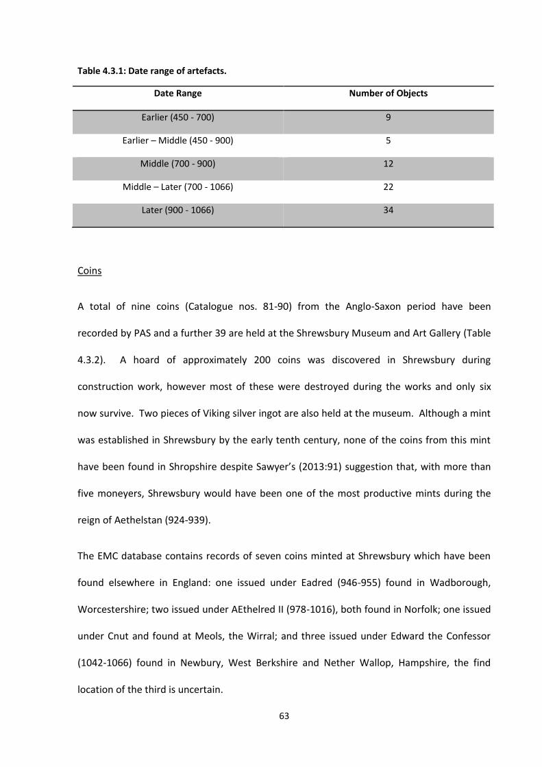
Table 4.3.1: Date range of artefacts. ..................................................................................................... 63
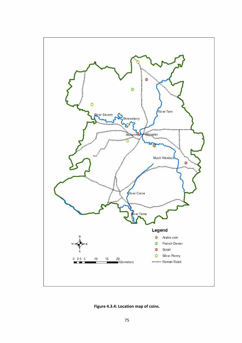
Table 4.3.2: Anglo-Saxon coins found in Shropshire. ............................................................................ 64
Table 4.3.3: Place-names related to economic function. ..................................................................... 65
List of Figures
Figure 1.1: Shropshire location map. ...................................................................................................... 1
Figure 1.2: PAS finds by period. .............................................................................................................. 5
Figure 4.1.1: Household figures for settlements in Shropshire recorded in Domesday Book. ............. 22
Figure 4.1.2: Map of woodland coverage. ............................................................................................ 28
Figure 4.1.3: The size and distribution of Anglo-Saxon settlements recorded in Domesday Book. ..... 29
Figure 4.1.4: Early Anglo-Saxon forts and settlement locations. .......................................................... 33
Figure 4.2.1: Map of place-name, architectural and artefact evidence, 7th - 9th centuries. ............... 50
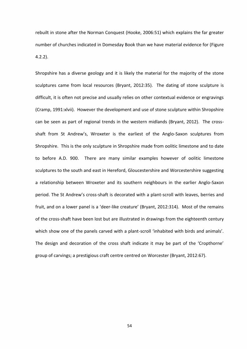
Figure 4.2.2: Location map of churches and sculpture identified in Shropshire, A.D. 700-1066. ........ 55
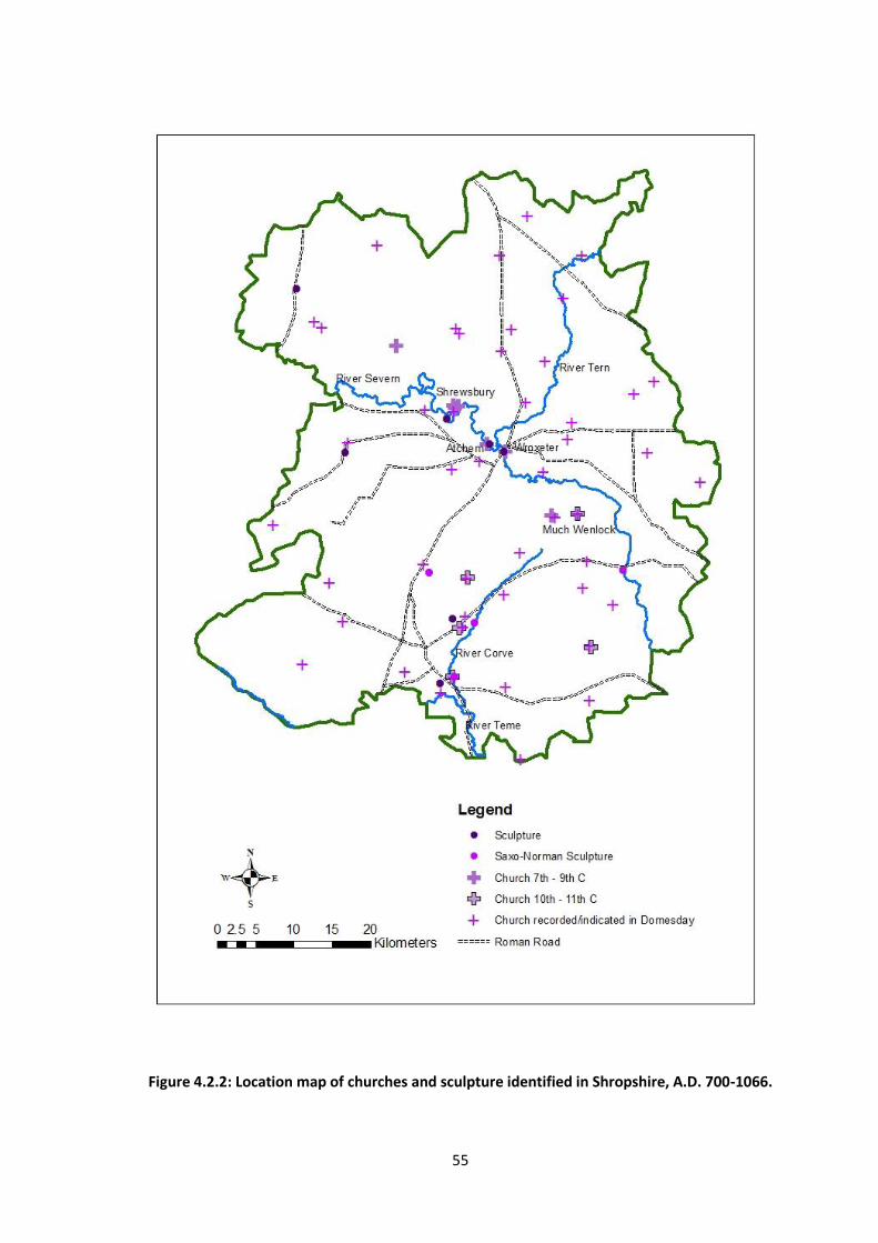
Figure 4.2.3: Map of the collected evidence for religion in Shropshire, A.D. 700 – 1066. ................... 60
Figure 4.3.1: The number of objects made from different material types. .......................................... 62
Figure 4.3.2: Map of evidence for the earlier Anglo-Saxon economy. ................................................. 68
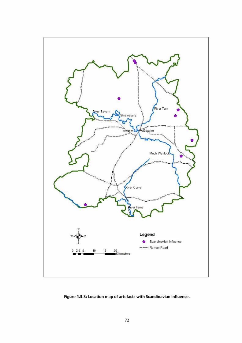
Figure 4.3.3: Location map of artefacts with Scandinavian influence. ................................................. 72
Figure 4.3.4: Location map of coins. ..................................................................................................... 75
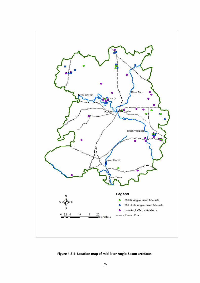
Figure 4.3.5: Location map of mid-later Anglo-Saxon artefacts. .......................................................... 76
Figure 4.3.6: Location map of PAS Early Medieval finds ....................................................................... 77
Figure 5.1: The numbers of Anglo-Saxon artefacts recorded by PAS for English regions. .................... 79
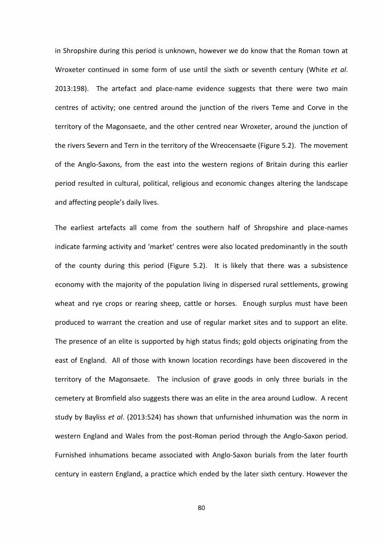
Figure 5.2: Map of evidence from the earlier Anglo-Saxon period. ...................................................... 83
Figure 5.3: Location of Shropshire in relation to the Diocese of Lichfield and the Danelaw ................ 87
Figure 5.4: Map of evidence from the mid-later Anglo-Saxon period. ................................................. 88
Figure 5.5: Map of evidence from the end of the Anglo-Saxon period. ............................................... 91
Page 6
1
1. Introduction
This research focuses on the use of combining new artefact data from the Portable
Antiquities Scheme database with existing sources of archaeological and historical data to
create an overview of the religious, economic and settlement changes in Shropshire during
the Anglo-Saxon period.
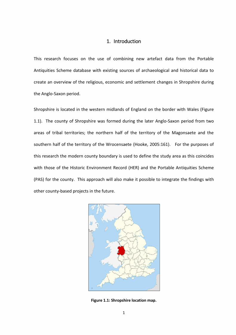
Shropshire is located in the western midlands of England on the border with Wales (Figure
1.1). The county of Shropshire was formed during the later Anglo-Saxon period from two
areas of tribal territories; the northern half of the territory of the Magonsaete and the
southern half of the territory of the Wrocensaete (Hooke, 2005:161). For the purposes of
this research the modern county boundary is used to define the study area as this coincides
with those of the Historic Environment Record (HER) and the Portable Antiquities Scheme
(PAS) for the county. This approach will also make it possible to integrate the findings with
other county-based projects in the future.
Figure 1.1: Shropshire location map.
Page 7
2
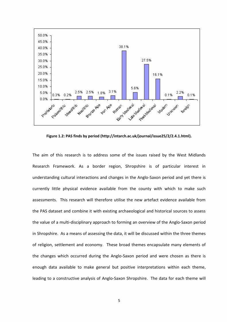
The usefulness of the PAS database to archaeological studies is becoming increasingly
recognised with 422 research projects currently utilising the record
(http://finds.org.uk/research). The Viking and Anglo-Saxon Landscape and Economy (VASLE)
project has used the PAS dataset in a national study of Anglo-Saxon England which
demonstrated the comparatively low level of artefacts from this period discovered in
Shropshire and West Central England in general. The authors suggest this may be due to
differences in the use of dress accessories in different regions, arguing higher levels of
migration in eastern England resulted in a greater use of material objects to display cultural
identity (Richards et al, 2009:69). The majority of finds recorded by PAS are discovered by
metal-detectorists resulting in an inherent bias in the dataset which needs to be considered.
The quantity and location of metal-detectorist finds are subject to numerous factors
including the number of detectorists within a given area and the accessibility of land.
For this research finds recorded by PAS for Shropshire will be combined with artefact
records from the Historic Environment Records (HER) to create a catalogue of Anglo-Saxon
finds for the county. This will be combined with other data sources including place-name
studies, stone sculpture and architectural studies, excavation reports and historical records.
This data will be entered into ArcMap to create both spatial and temporal distribution maps
which can be analysed to contribute to our knowledge of the Anglo-Saxon period in
Shropshire.
This study is focused on the date range A.D. 600-1066. Prior to this there is little information
available for the Anglo-Saxon period from which a character assessment could be formed.
The seventh century however marks the beginning of a ‘revival’
(http://www.york.ac.uk/archaeology/vasle/vasleoverview.html); an increase in trade,
Page 8
3
settlement and production, as well as the re-emergence of coinage, all seen in England by
the end of this century. The spread of Christianity was an important religious, social and
economic factor which shaped the development of religious activities and also stimulated
the economy and prompted the establishment of new settlements. Although the west of
England and Wales remained largely Christian after the end of the Roman period the
emergence of a new wave of Christian evangelism following the arrival of Augustine in Kent
in 596 and the conversion of Anglo-Saxon kings resulted in a strong bond between Church
and State. This powerful combination was to influence both the religious and secular
aspects of people’s lives. The construction of Church buildings and the subsequent
development of markets along with the creation of urban centres changed the landscape of
England dramatically during the period.
The ninth century was also a time of immense change as Shropshire became subject to
incursions by the Vikings as did the rest of England. Although there are not thought to have
been any Viking settlements in Shropshire, the Anglo-Saxon Chronicle (ASC) does record
sporadic Viking attacks from the later ninth century into the early tenth century when
Aethelflaed responded by constructing fortresses at Bridgnorth and Chirbury. An increase in
the number of artefacts found dating to the later Anglo-Saxon period is seen in Shropshire as
elsewhere in England, suggesting an increase in wealth, or in the display of wealth, and a
stabilisation in the trade of raw materials and finished objects, further suggesting political
and social stabilisation.
The Norman Conquest of 1066 is the traditional date marking the end of the Anglo-Saxon
period. The Conquest brought social, political and economic changes, some of which are
recorded in the Domesday Book of 1086. The Domesday survey provides a valuable
Page 9
4
snapshot of England at the end of the Anglo-Saxon period recording landholders and their
tenants, the number of households, buildings and resources.
The Anglo-Saxon period covers over 600 years and as Pelteret (2000:xix) states ‘change was
inevitable, in mental and religious outlook, in material culture, in social organisation, in
political and legal practice’. However as a ‘proto-historic’ period often less is known about
the Anglo-Saxon period than the earlier Roman period. There are many forms of
documentation from the Anglo-Saxon period, notably the Anglo-Saxon Chronicle and Bede’s
Ecclesiastical History of England. But even these respected writings are limited in their
geographical and political scope with the authors being constrained by their own beliefs,
experiences and social contacts (Pelteret, 2000:xxii). Hines (2002) has argued that
archaeology can tell a ‘better’ story for this period than can history and indeed archaeology
is shedding new light on the period. In the West Midlands region Research Framework
(Hines, 2002) it is suggested that finds recorded by PAS will be an important and significant
contribution to studies on the Anglo-Saxon period. Recent finds such as the Staffordshire
Hoard (www.staffordshirehoard.org.uk) are leading to radical changes in the way in which
we think about power, wealth and warfare at this time. However the VASLE project has
shown that the finds recorded by PAS for the Anglo-Saxon (Early Medieval) period are
considerably lower than those for the preceding Roman period and the following Late
Medieval period (Figure 1.2). Due to the lower level of artefact finds, the usefulness of
place-name studies and aerial photography were also highlighted in the West Midlands
Research Framework. It was concluded that the combined use of these sources together
with results from excavations, placed within a regional and national context will be a positive
contribution to the study of the Anglo-Saxon period of the West Midlands region.
Page 10
5
Figure 1.2: PAS finds by period (http://intarch.ac.uk/journal/issue25/2/2.4.1.html).
The aim of this research is to address some of the issues raised by the West Midlands
Research Framework. As a border region, Shropshire is of particular interest in
understanding cultural interactions and changes in the Anglo-Saxon period and yet there is
currently little physical evidence available from the county with which to make such
assessments. This research will therefore utilise the new artefact evidence available from
the PAS dataset and combine it with existing archaeological and historical sources to assess
the value of a multi-disciplinary approach to forming an overview of the Anglo-Saxon period
in Shropshire. As a means of assessing the data, it will be discussed within the three themes
of religion, settlement and economy. These broad themes encapsulate many elements of
the changes which occurred during the Anglo-Saxon period and were chosen as there is
enough data available to make general but positive interpretations within each theme,
leading to a constructive analysis of Anglo-Saxon Shropshire. The data for each theme will
Page 11
6
be considered separately before the analysis from all three sections will be brought together
in the discussion chapter.
Page 12
7
2. Literature Review
The general dearth of written and material evidence from Mercia led Hodgkin (1939:194) to
conclude that ‘the early history of Mercia is so dark that it is better to pass it by and admit
the impossibility of putting together any trustworthy story’. By the 1970s new approaches
to studying the past led Dornier (1977:11) in the edited volume Mercian Studies to pose a
more optimistic view of piecing together our knowledge of Mercia with many chapters
based on re-readings and new interpretations of the historical evidence (Davies, 1977; Hart,
1977; Kirby, 1977; Phythian-Adams, 1977). The archaeological evidence available for
consideration in the 1970s consisted primarily of coins (Metcalf, 1977) and earthworks,
which, as Rahtz (1977:127) acknowledged has increased our knowledge of the economy and
urbanisation of western Mercia. However, low levels of excavation meant the evidence was
far less substantial than that in eastern England.
At the beginning of the twenty-first century the quantity and range of archaeological finds
from western Mercia had not greatly improved. During a series of conferences arranged to
discuss the archaeology of the West-Midlands, Hines (2002) pointed out the challenges of
the scarcity of finds; leading to a reliance on historical evidence for a region which is at best
‘para-historical’. Stamper (2003) further argued that Shropshire in particular, is one of the
more under-researched counties for medieval archaeology. Hines (2002) concluded
however by arguing that through the integration of historical, place-name and
archaeological evidence, we can create a ‘meaningful, composite picture’.
Baker (2010) has produced a comprehensive volume on the archaeology of Shrewsbury,
from the prehistoric to post-medieval period, addressing issues raised by Hines (2002) and
Stamper (2003). The origins of Shrewsbury are currently unknown, but its location on a
Page 13
8
hilltop within a naturally defensive loop of the River Severn may have made it an attractive
settlement site to the first communities (Baker, 2010:89). Finds from the Anglo-Saxon
period are sparse however pottery finds have indicated the Anglo-Saxon town was of a
similar extent to the late medieval town (Baker, 2010:99). Shrewsbury is first mentioned in a
royal charter, signed in 901, awarding a grant of land to Wenlock Abbey by Aethelred and
Aethelfled. Baker (2010:89) has interpreted the signing of the document in Shrewsbury as
testament to the existence of a royal hall. Baker (2010:89) further suggests that Shrewsbury
may have had a ‘ceremonial importance’ by 1006, when according to the Anglo-Saxon
Chronicle, King Aethelred spent midwinter there. The evidence for a mint by the tenth
century and Bassett’s (1991) study of six pre-Conquest churches within the town,
demonstrate the importance of Shrewsbury ‘in the secular sphere, as well as the
ecclesiastical – which was out of all proportion to its surviving recorded history’ (Bassett,
1991:17). Baker’s study has created a fuller and rounder understanding of the development
and role of Shrewsbury through the Anglo-Saxon period and Stamper (2003) has called for
similar work to be conducted in Bridgnorth and Ludlow to further enhance our
understanding of the development of the county as a whole.
W.G. Hoskins’ (1955) seminal work The Making of the English Landscape, was perhaps the
first volume to draw together historical studies with place-name studies, archaeology and
field work to create an account of the development of the English landscape. Hoskins
(1955:45) realised the significance of charter bounds in tracing the boundaries of estates and
understanding the Anglo-Saxon landscape and the hierarchies of settlements, work that has
been continued by Della Hooke. Hooke has written extensively on the landscape of the
West Midlands region, using charter boundary evidence for studies on the Anglo-Saxon
Page 14
9
landscapes of Staffordshire (1983), Warwickshire (1999) and Worcestershire (1990). Such
detailed evidence does not survive for Shropshire however Hooke (2006:52) does believe
that a general picture of whole of the West Midlands region can be postulated; as a
landscape dominated by dispersed farmsteads in the early Anglo-Saxon period with new
estates centres forming nuclei around which settlements became concentrated by the late
8th century.
The use of place-name evidence in archaeological studies has become increasingly common
as landscape archaeology has developed. Ryan (2011:5) argues that place-names were
important in the Anglo-Saxon period, to the extent that ‘historical’ figures were created in
order to explain a place-name. Stenton (1969:37) believed habitative place-names were of
most value in understanding the social history of the Anglo-Saxon period, considering
topographical names to be ‘intrinsically trivial’. Margaret Gelling’s ground-breaking work
since the 1970s has emphasised the importance of topographical place-names and the
subtleties of Anglo-Saxon place-names which is often lost in crude translations. Gelling
(1997:131) has illustrated the importance of place-names as a means of accessing how
Anglo-Saxon settlers interpreted their landscape. Hare (2012:7) suggests that place-names
found in charters from 670 onwards, suggest that English was being used in the border
region from at least the 7th century, although Gelling (1990:xiv) believes this may represent
an initial small group of English administrators in the area, with an increasing English
population from the eighth century as Mercia expanded westwards. Gelling’s (1990 et seq.)
volumes on Shropshire place-names are particularly informative as to the origins and
meanings of place-names. They demonstrate how place-names can be used to re-create the
Page 15
10
landscape of natural and built features, activities and settlements, and understand how
people in the Anglo-Saxon period engaged and interacted with their environment.
Through the 8th century minsters were significant developments in the Anglo-Saxon
landscape, only gradually losing their importance to the developing network of local
churches in the eleventh century (Blair, 2005:505). Blair (2005:6) has argued ecclesiastical
centres were dynamic initiators in changing the economic and social structures of secular life
in Anglo-Saxon England; whilst hugely variable in size and wealth, they were centres around
which communities gathered, and agriculture, industry and urbanism developed. Higham
(1997) has described how the organisational, ideological and authoritarian structure of the
Christian Church attracted even secular Kings in the early Anglo-Saxon period to convert to
Christianity as a means of unifying their subjects and solidifying and displaying their own
power. The arrival of the Vikings impacted on many ecclesiastical institutions in the east of
England but Blair (2005:306) argues that the west of Mercia remained a far more stable
region with a greater level of continuity within minster communities. Archives from
Worcester demonstrate the successful continuation of the minster here during the later
Anglo-Saxon period and Blair (2005:207) believes the archaeological evidence for other
mother-churches in the region demonstrates steady development, with many Mercian
towns, including Shrewsbury, having multiple ministers by the eleventh century.
The burh name element in Scropesbyrig is indicative that Shrewsbury was fortified at some
point, although exactly when is debated; Baker (2010:89) believes this would have occurred
during the 930s when the town was appointed a mint. Bassett (2008:232) argues the
original defences may have been earlier; his study of the Mercian defences at Hereford,
Tamworth, Winchcombe and Worcester suggests that initial defences were constructed at
Page 16
11
these sites during the period of Mercian over-lordship in England, with second stage
defences constructed during the reigns of Aethelred and Aethlflaed in the early tenth
century, with further enhancement during the reign of Aethelred II (975-1016). Bridgnorth
was fortified in 912 by Aethelflaed, possibly making use of an earlier fortress constructed
here by the Vikings in 895, securing an important crossing point on the River Severn and
consolidating Mercian control (Walker, 2000:100). As Hooke (2006:57) states, the
construction of minsters and burhs would have made ‘a considerable impression on the
landscape’. This is especially true in the early medieval rural landscape of Shropshire where
the majority of settlements would have consisted of a few small buildings of timber and
thatch construction as indicated by the excavations of a settlement at Atcham (Hannaford,
1998).
There are two primary databases which record the material culture of Shropshire: the
Historic Environment Record (HER) and the Portable Antiquity Scheme (PAS). With an
increase in urban development in the 1960s it was realised that much of the historic
environment was being damaged or lost, resulting in the establishment by the end of the
decade in the first county archaeologists and the creation of the Sites and Monuments
Records (SMR’s) (RCHME, 1993:2). Now referred to as the Historic Environment Record
(HER), the database contains a broader scope of information including archaeological sites,
finds and features, historic buildings, structures and landscapes
(http://shropshire.gov.uk/environment/historic-environment/shropshire-historic-
environment-record/).
The HER for Shropshire holds over 23,000 records although only a small percentage of these
relate to the Anglo-Saxon period. Of these, many have broad date ranges beyond the
Page 17
12
generally accepted A.D. 410 – 1066 dates of the period; only 26 records have been
confirmed as dating to the later Anglo-Saxon period. This supports Baker’s (2010:xiii)
argument that there are so few artefacts due to the lack of excavation, associated with the
low level of modern construction within the county, and also the scarcity of finds from
excavations which have taken place.
The Portable Antiquity Scheme (PAS) was launched as a pilot scheme in 1997 as a means of
encouraging the voluntary reporting of archaeological finds made by members of the public,
the majority of which are found by metal-detector hobbyists, which are not covered by the
Treasure Act of 1996 (http://finds.org.uk/info/advice/aboutus). The success of the pilot PAS
resulted in an expansion of the scheme to encompass the whole of England and Wales in
2003 (Bland, 2004:272). Over the past decade, the finds recovered and recorded from
Shropshire by non-professionals has increased due to the establishment of the PAS;
currently totalling 62 artefacts dating from 600 – 1066. The majority of these are small
metal finds, which can be broadly categorised into horse fittings (strap ends, stirrups, bridle
fittings etc.), dress fittings (brooches, pins etc.) and coins.
PAS’s contribution to archaeological studies and knowledge has been controversial with
some believing it has created a situation in which artefacts are valued primarily as
commodities rather than for their ‘scholarly and social values’ (Saville, 2006:71). However
the PAS has currently recorded almost 700,000 objects, forming a valuable collection of
artefacts and enhancing our understanding of the past (www.finds.org.uk/research). The
standardisation of recording and the improvements in accessing data over the past decade
has led increasingly to the PAS data being used by both commercial and academic
archaeologists, bringing new avenues of insight into their work (Pett, 2010). This has been
Page 18
13
demonstrated by McLean and Richardson’s (2010) study of Anglo-Saxon brooches from Kent.
The study found that artefacts recovered by metal-detectorists are more likely to have been
deposited due to casual loss and come from areas frequently used but not cleaned, for
example on the fringes of settlements or the routes between settlements (McLean and
Richardson, 2010:170). In contrast, finds from archaeological excavations are more
representative of deliberate deposition of objects in a funerary context or from settlement
contexts (McLean and Richardson, 2010:163). Through comparison of finds, McLean and
Richardson (2010:170) were able to discern that certain types of brooches were worn in life
and others associated with the dead, demonstrating the significance of particular styles of
brooches with aspects of cultural behaviour and belief.
Although the numbers of objects from Shropshire for the Anglo-Saxon period are still
relatively limited in comparison with counties in the south and east of England, excavations
from the surrounding region have revealed finds that indicate the type of objects that were
coming into the region. The site of Meols on the Wirral Peninsular was a settlement and
trading port, with over 5000 finds recovered dating from the Mesolithic to the post-medieval
period (Griffiths et al. 2007). The proportion of finds dating to the Anglo-Saxon period are
again scarce in comparison to finds from the Roman and later medieval periods (Griffiths et
al. 2007:15). Griffiths (2007b:402) believes the pattern of finds suggest a decline in activity
in the area in the 7th and 8th centuries but an upsurge from the end of the 9th century
possibly due to the expulsion of Vikings from Ireland at this time. Although there is no
evidence of Viking activity or settlement within Shropshire, it is possible that the increase in
activity and prosperity in the Wirral would have had an impact on people in the surrounding
area.
Page 19
14
Another useful source of information providing an insight into the lives of people in the
Anglo-Saxon period is sculpture. Although Anglo-Saxon stone sculptures have been an area
of study since the late 19th century, the focus has generally been on the more numerous
sculptures from eastern and northern England (Hare and Bryant, 2012:1). In Brown’s (1937)
The Arts in Early England, he estimated a total of only 37 sculptures survived for the entire
Western Midlands region. The Corpus of Anglo-Saxon Stone Sculpture is a series of regional
volumes which catalogues and investigates both previously published and unpublished stone
sculptures. Volume X (Hare and Bryant, 2012) covers the Western Midlands area, and is the
first comprehensive publication of sculptures from western Mercia recording seventeen
pieces of Anglo-Saxon stone sculpture and a further seven pieces from the Saxo-Norman
period for Shropshire alone. The various influences on art and sculptures within the region
and the development of the Mercian art style are charted. The volume demonstrates that
even after the ‘fall’ of Mercia and the unification of England, the craftsmen within Mercia
continued to produce high quality stone sculptures.
In Cramp’s (2009:49) discussion of the developments of artefact studies over the last 50
years of medieval archaeology, she argues for the importance of the movement within
archaeology away from studying artefacts within the context of a single site to interpreting
them within the context of an entire landscape. By bringing together contemporary
approaches to the interpretation of material culture with landscape studies, it is hopefully
possible to develop an account of the lives of people within later Anglo-Saxon Shropshire
which is currently absent from the Anglo-Saxon literature.
Page 20
15
3. Method
Several sources of data were used to analyse activity in Shropshire during the Anglo-Saxon
period with the two primary sources of artefact records being the PAS and HER online
databases (http://finds.org.uk/; http://www.heritagegateway.org.uk/). In addition the
Corpus of Anglo-Saxon Stone Sculpture vol. X (Bryant et al. 2012) was used as it is the most
complete and recent catalogue of stone sculpture identified within the county. Gelling’s
(1990) Place-Names of Shropshire part 1 was also used as a comprehensive survey of the
meanings of the major place-names of Shropshire. This volume only was used as it includes
all of the place-names recorded in Domesday Book and to have attempted to have included
all the minor place-names would have resulted in a project beyond the scope of this current
research. Domesday Book as translated by Thorn and Thorn (1986) was also utilised to
obtain data relating to the population of Shropshire.
The results of two projects were used to provide a means of cross-checking the data from
the sources above and to provide a national context to the data for Shropshire. The Central
Marches Historic Towns Survey 1992-6 was funded by English Heritage as part of the
Extensive Urban Survey project; the project reports can be found at
http://archaeologydataservice.ac.uk/archives/view/marches_eus_2005/. A total of sixty-
four towns (excluding county towns) were surveyed across Herefordshire, Worcestershire
and Shropshire. The study utilised a range of sources including HER, historic buildings
listings, archaeological reports, museum collections, published historical sources, place-
name studies and fieldwork data to identify the archaeological potential of towns relevant
local planning authorities. Twenty-nine towns were surveyed within Shropshire, at least
Page 21
16
twenty-three of which were found to have existed in some form during the Anglo-Saxon
period.
Results from the Viking and Anglo-Saxon Landscape and Economic project (VASLE) were also
consulted to provide a national context to the findings from Shropshire. Based at York
University and funded by the Arts and Heritage Research Council (AHRC), the digital archive
can be found at http://archaeologydataservice.ac.uk/archives/view/vasle_ahrc_2008/. The
study focused on artefacts recorded by PAS and the Early Medieval Corpus (EMC)
(http://www-cm.fitzmuseum.cam.ac.uk/emc) in England and Wales, mapping the finds and
using the data to ‘write a new economic and landscape history of England c.AD700-1000’.
Additional sources of data used to supplement those above were:
Early Medieval Corpus of Coin Finds (EMC)
Shrewsbury Museum
Aerial Photography
Excavation Reports
Anglo-Saxon Architecture
In order to analyse the data it was inputted into ArcMap to map the data both spatially and
temporally. Patterns and trends within the data could then be identified and interpreted.
Before this could be done the data from the various sources was used to create databases.
This process involved a standardisation of the data and once completed provided a quick
and simple means of grouping and selecting data based on a given criteria such as date
range.
Page 22
17
The artefact data from the PAS and HER was compiled into a single database with the
following fields:
• PAS / HER Record ID
• Object Type
• Classification
• Length
• Height
• Width
• Thickness
• Diameter
• Weight
• From Date
• To Date
• Description
• Notes
• Date Found
• District
• Parish
• Known As
• Grid Reference
• Subsequent Action
• Current Location
• Discovery Method
In addition the following fields were also used for coins:
• Ruler Name
• Mint Name
• Denomination
• Category Term
• Type
• Obverse Description and Legend
• Reverse Description and Legend
The information from this database was then combined with artefact records from
excavation reports to create an illustrated catalogue of the artefacts that have been
discovered in Shropshire which date from A.D. 600 – 1066 (Appendix 1). Three further
objects have been discovered near Wroxeter during the Wroxeter Hinterland Project.
Page 23
18
However these have not been included here as detailed descriptions of the objects have not
yet been recorded. Where artefacts were recorded on multiple sources the data from all
sources was used in order to create a catalogue with the most complete information
possible.
Where alternative date ranges were given for objects or differing interpretations of objects
have been made, these have been noted in the catalogue. Records for some artefacts were
incomplete and in some instances the find location is restricted on the PAS website.
Therefore the level of information in the database and catalogue is not as consistent as
would have been desired and objects without a spatial reference have not been entered on
ArcMap but have been included within the analysis and discussion sections below. An
additional record of coins found within Shropshire and held by Shrewsbury Museums was
obtained from the museum services. These objects have also been discussed where relevant
but have not been mapped as they did not have find locations recorded.
The sources relating to church evidence was combined into a single database (Appendix 2) to
list all the named churches for which there is evidence and the types of evidence recorded
for each church with the following fields:
• Church, Location
• Grid Reference
• Architectural Evidence (from Taylor and Taylor, 1978)
• CMHTS
• Domesday Book
• Sculpture (from Bryant et al. 2012)
Page 24
19
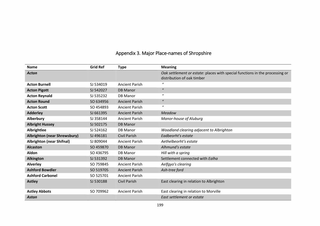
118 major place-names taken from Gelling (1990) were also recorded in a database
(Appendix 3) with the following fields:
• Place-name
• Grid Reference
• Ancient Parish or Manor
• Meaning of name
The Ordnance Survey 2014 edition 1:50 000 map of Shropshire was downloaded from Edina
Digimap to use as a base-map within ArcMap. Line shape files were created to digitise the
county border, the four main rivers (Severn, Teme, Corve and Tern) and the Roman road
network. Point shape files were created for the various categories of data. Individual point
shape files were created for artefacts by type and also by date. The data indicating religious
activity, settlements, fortifications, production sites and markets was also mapped using
point shape files.
Once digitised the data could then be manipulated to analyse patterns and changes within
the religious, settlement and economic practices within Shropshire from A.D. 600 - 1066.
Page 25
20
4.1 Settlement
Anglo-Saxon settlements can be notoriously difficult to identify. Before A.D. 900 there were
very few settlements that could be considered ‘towns’ in England; small rural settlements
were scattered across the landscape. In the early tenth century the urbanisation of
settlements intensified across England due in part to the combination of two factors; the
establishment of minsters which stimulated the growth of new settlements and trade, and
new laws enacted by Aethelstan (924-39) which limited trade involving transactions over
twenty pennies to within towns (Griffiths, 2011:160). Hamerow (2012:2) points out that
most Anglo-Saxon settlements now consist only of ‘postholes, pits and ditches’ and are often
‘disappointingly clean’ in terms of material remains. Hamerow (2012:3) argues that the
scarcity and unpredictable nature of the distribution of settlements during this period
compounds the difficulty of identifying potential sites for archaeological investigation.
However it is possible to develop a picture of Anglo-Saxon settlement in Shropshire by using
a range of information sources.
The sources of data used to assess the settlement character of Shropshire were the Central
Marches Historic Town Survey, Domesday Book (Saunders, 1954; Thorn and Thorn, 1986),
place-name evidence (Gelling, 1990), evidence from archaeological excavations in
Shrewsbury (Carver, 1983), aerial photography, and artefacts recorded with the PAS and the
HER.
Central Marches Historic Town Survey
A total of 29 towns in Shropshire were surveyed as part of this project, 23 of which were
found to have evidence for some form of settlement during the Anglo-Saxon period. A
Page 26
21
further two towns, Ludlow and Wem, are thought to have originated after the Anglo-Saxon
period but manors are recorded in Domesday at Ludford, near to Ludlow, and at Wem which
CMHTS argue were likely to have contained earlier settlements. Evidence for the presence
of Anglo-Saxon settlements came primarily from Domesday Book and place-name evidence.
Field-walking was undertaken as part of the project but no artefacts dating to the Anglo-
Saxon period were recovered.
Domesday Book
The Domesday Book was compiled in 1086 as a consequence of the Norman Conquest and
was initiated as a means for the new King William I and his barons to have an accurate
record of whom owned what land, the income generated from that land and the taxes due
to the King (Loyn, 2003:19). As a result of this the Domesday survey is not a comprehensive
account of the population in the later eleventh century; Loyn (2003:24) warns that caution is
required when Domesday is used to attempt to calculate population levels due to the
‘uncertainties, omissions, variations in procedure and assumptions’ in the Book. The
Domesday Book records 440 separate places within the modern county of Shropshire
(Saunders, 1954:115), of which 410 have the number of households recorded (Figure 4.1.1).
The recorded population was listed under five major categories, giving a total recorded
population of 4,907 (Tables 4.1.1 and 4.1.2). Saunders (1954:127) also records 88
bondwomen, 9 female cottars and 2 widows who are not included in the major categories,
giving a total recorded population of 5,006. However, it needs to be remembered that this
figure reflects the recorded tax-paying population and cannot be assumed to reflect the
actual population of Shropshire at the time. The population of Shrewsbury is considered
Page 27
22
separately in Domesday with 252 houses recorded, three moneyers and a total tax payment
of £30 per annum.
Figure 4.1.1: Household figures for settlements in Shropshire recorded in Domesday Book.
Table 4.1.1: Rural population of Shropshire recorded in Domesday Book (after Saunders, 1954:127).
Category Recorded Population
Villeins (the wealthiest dependant manorial
peasantry)
1,987 (40%)
Borders (dependant manorial peasantry with less
land than a villein)
1,196 (24%)
Serfs (or slaves) 922 (19%)
Oxmen (drove the plough beasts) 361 (7.5%)
Radmen (riding escort for a lord) 168 (3.5%)
Miscellaneous 273 (6%)
Total 4,907
146
114
62
2429
13 14
4 2 2
0
20
40
60
80
100
120
140
160
1-5 6-10 11-15 16-20 21-30 31-40 41-60 61-80 81-100 100+
Nu
mb
er o
f Se
ttle
men
ts
Number of Households
Page 28
23
Table 4.1.2: Details of the 'Miscellaneous' population of Shropshire recorded in Domesday Book (after Saunders, 1954:127).
Category Population Category Population
Welshman 64 Smiths 8
Priests 53 Coscets 8
Frenchmen 34 Reeves 7
Freemen 23 Hospites 7
Men 17 Serjeants 6
Cottars 16 French serjeants 3
Coliberts 13 Bee-keeper 1
Knights 12 Miller 1
Total 273
Place-name Evidence
There are 126 major place-names related to the Anglo-Saxon period recorded in The Place-
Names of Shropshire, Part 1 (Gelling, 1990). Gelling (1990:xi) defines ‘major’ place-names as
those of ‘all parishes and all identifiable Domesday manors’. There are surprisingly few pre-
English names in Shropshire which Gelling (1990:xii) argues is probably due to an effective
Mercian administration rather than a dominant Anglo-Saxon population.
Place-names are derived from a range of sources including personal names, geographic
locations, topographical features and economies. There are several major place-names
which can indicate settlement patterns; eight place-names contain the Old English element
ac-tun, ‘oak settlement or estate’, 10 containing leah, ‘woodland clearing’, five containing
byrig, ‘settlement associated with a fort’ and three containing burweard, ‘fort guardian’. A
Page 29
24
more detailed study by Gelling (1992:15) maps all of the major and minor place-names in
Shropshire containing the leah element which shows two predominant clustering’s of
woodland, one running across the central belt of Shropshire and the other in the south-
eastern corner.
Archaeological Excavations
There have been few archaeological excavations of Anglo-Saxon period sites in Shropshire.
Excavations in the early 1970s in Shrewsbury at the sites of two medieval houses, Pride Hill
Chambers and Rigg’s Hall, did provide evidence for occupation from the 10th century (Carver,
1983). Stake-lined cess-pits dating to the 10th or 11th centuries were identified at Pride Hill
Chambers and were found to contain eighty-six fragments of animal bone predominantly
cattle and pig. The majority of the fragments came from body parts conventionally
designated as slaughter or waste (Noddle, 1983:34). A bone tool, 12.6cm in length, and one
sherd of Stamford-type ware dating from the 10th-12th centuries were discovered at Pride
Hill Chambers (Morris, 1983:27). The pits found at Rigg’s Hall also contained domestic and
butchery waste; 185 bones from ox, sheep, horse, goose, frog and fish were present and also
a partially complete skeleton of a dog (Locker, 1983:61). Plant remains were recovered,
predominately containing cultivated oat and also barley and wheat (Colledge, 1983:62).
Stafford-type ware, Stamford-type ware and St Neots-type ware, generally dated to the 10th
– 12th centuries were recovered from an earth bank, the construction of which possibly
occurred c. 1150 – 1220, which Baker (1983:63) argues makes it likely that the pottery also
belongs to the 12th century.
Page 30
25
Artefacts
The majority of Anglo-Saxon artefacts have been discovered in or near to settlements with
the exceptions of two clusters; one in the north of the county (south of Whitchurch) and the
other in the north-west near Oswestry.
A total of 11 artefacts have been discovered which could be interpreted as being directly
associated with settlements or domestic activities (Table 4.1.3).
Table 4.1.3: Artefacts associated with settlements.
Object Location Date
Spindle whorl Albrighton 410 – 1066
Furniture fitting Market Drayton 700 – 1200
Handle mount Prees 700 – 1066
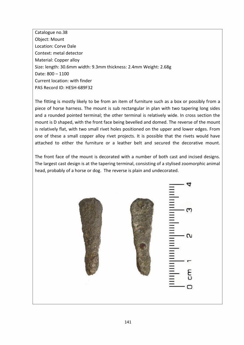
Furniture mount Corve Dale 800 – 1100
Pottery rim sherd Wroxeter and Uppington 750 – 850
Pottery sherds Shrewsbury 800 – 1499
Pottery body sherd Newport 900 – 1100
Pottery body sherd Wroxeter and Uppington 1000 – 1200
Pottery Shrewsbury Late Saxon
Pottery Shrewsbury Late Saxon
Pottery Shrewsbury Late Saxon
Page 31
26
Aerial Photography
Air reconnaissance in 1975 showed crop marks located at SJ 552115, in the parish of Atcham.
The crop marks revealed the outlines of what has been interpreted as two timber buildings,
running north-east – south-west, set along the axis of a gravel ridge with a group of
overlapping enclosures to the north-east (St. Joseph, 1975:293). Both buildings are
rectangular; one has a porch addition giving a total dimension of 8m x 21m, the other has
small subdivisions at either end giving a total dimension of 8m x 24m. Faint marks along the
interior may be post holes suggesting this structure was an aisled building (St. Joseph,
1975:294). The scale and plan of these buildings is comparable with great halls in the 7th
century at Yeavering (Hope-Taylor, 2009) and the 9th century at Cheddar (Rahtz, 1979)
leading to the suggestion that the Atcham site may be a royal palace (St. Joseph, 1975:295).
4.1.1 Analysis
A major issue in analysing settlement in Shropshire during the Anglo-Saxon period is the lack
of specific dating evidence for the origins of settlements. However the Domesday Book
provides a detailed source of evidence for settlement in Shropshire at the end of the period
and as some place-names can be seen to have evolved from pre-English names or to have
originated with the arrival of an Anglo-Saxon administrative unit, these settlements can be
assumed to have been in existence from the earlier Anglo-Saxon period.
Environment
Shropshire can be viewed as a county of two halves with the River Severn forming the
dividing line. The northern half of the county is the southern end of the Cheshire plain, a flat
Page 32
27
expanse of land, extending northwards to the River Mersey. The upland southern half of the
county has a different topography with parallel ridges of hills and valleys running north-east
to south-west.
Place-names suggest that the eastern half of the county was more heavily wooded than the
west, with concentrations of leah place-names in the north-eastern and south-eastern
corners, and two belts of woodland, one running north – south from Leegomery to
Meadowley, and the other running east – west from Farley to Leigh (Figure 4.1.2). The
dispersal of leah place-names corresponds with Hooke’s (1998:162) argument that during
the Anglo-Saxon period woodland was likely to be of an ‘open’ character, which would have
been more productive for stock grazing.
Hooke (1998:162) argues that settlements in wooded areas across England tended to remain
dispersed through the Anglo-Saxon period rather than forming nucleated settlements. This
is possibly due to the predominance of pastoral as opposed to arable farming in this type of
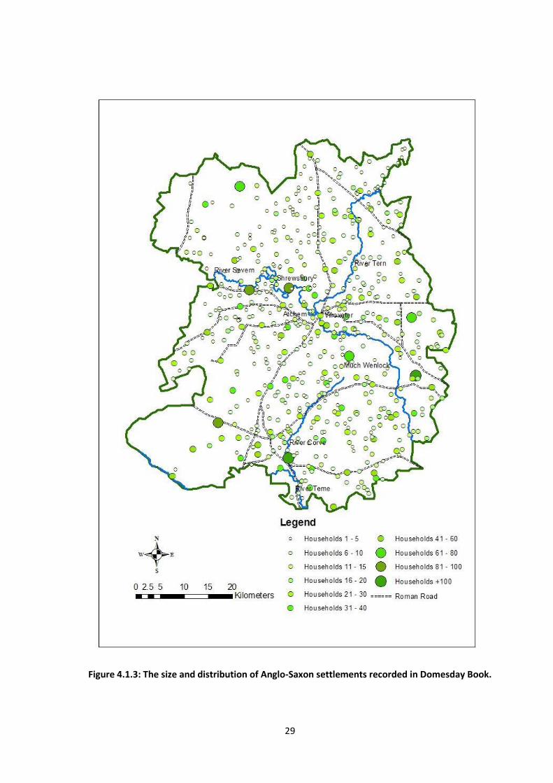
environment. This is a settlement pattern which can be recognised in Shropshire (Figure
4.1.3) with the vast majority of people living in dispersed settlements with fewer than 10
households at the time of the Domesday survey (Table 4.1.1). Animal bones found at Pride
Hill Chambers, Shrewsbury indicate that there was hunting of red and roe deer suggesting
open woodland in the vicinity. The variety of other animal bones and plant remains also
demonstrate that ‘there was a dependency on mixed farming, not dissimilar to modern
Shropshire’ (Carver, 1983:42). Place-name evidence also gives support to this type of
landscape with many places named after the farming which occurred at the site; Bitterley,
meaning ‘butter pasture’, Cheswardine, meaning a ‘cheese-producing settlement’, Ryton
Page 33
28
meaning ‘rye farm’, and Shipley and Shipton meaning ‘sheep clearing or pasture’ (Gelling,
1990).
Figure 2.1.2: Map of woodland coverage.
Page 34
29
Figure 4.1.3: The size and distribution of Anglo-Saxon settlements recorded in Domesday Book.
Page 35
30
Earlier Anglo-Saxon Period
During the Iron Age the hillfort on the Wrekin was the capital of the Cornovii, this moved to
Wroxeter in the Roman period, becoming the fourth largest town in Britain. Although the
town declined during the fourth and fifth century’s, recent evidence suggests the site
continued in use beyond the end of the Roman period, with occupation finally ending
around 650 (White et al. 2013:194). Shrewsbury later became the central settlement within
the region, developing at some point during the ninth century. This gives a potential gap of
approximately two centuries between the functional uses of the two sites. Aerial
photographs of crop marks at Atcham may reveal the missing link in the movement of the
power base in the region during the earlier Anglo-Saxon period (pers. comm. Dr R. White).
The photographs show the outlines of two structures which have been interpreted as an
Anglo-Saxon palace site (St. Joseph, 1975:293). The site has been scheduled but no
excavation has yet been conducted which could improve our knowledge of the site.
However if the site is a palace, one hypothesis is that it could have been constructed in the
early – mid seventh century when Penda was enlarging Mercia and the region came under
Anglo-Saxon control. Excavations at Wroxeter have shown that it continued in use after the
Roman period, however Barker et al (1997:247) have argued that control may have passed
to a local ‘powerful magnate of some kind’, but one with little contact with the outside
world. The establishment of a new Anglo-Saxon royal power in the region, in need of
displaying their own authority could explain the establishment of a new, central royal
settlement at Atcham.
The kingdoms of the Hwicce and the Magonsaete were subsumed into Mercia during the
reign of Penda (c.626-655). Following this accession there is no record of Penda having
Page 36
31
fought against the Welsh of Powys, indeed they became allied against the Northumbrian
Kingdom. However a dynasty of Welsh kings ruled Ergyng (south Herefordshire) through the
sixth and early seventh centuries and actively fought against the Saxons (Hooke, 2006:43). A
battle is recorded in 760 at Hereford and it may have been this threat from the south which
resulted in the need for the construction of forts to protect important centres.
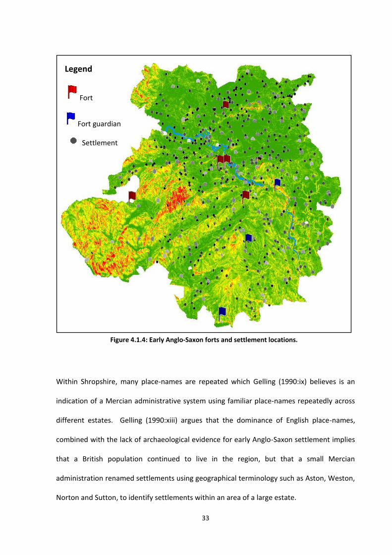
Place-name evidence suggests that there were five sites where forts were located in the
earlier Anglo-Saxon period (Figure 4.1.4). Dating evidence would be incredibly valuable in
determining when these forts were initially constructed and any subsequent periods of use.
The forts are spread throughout the county and Gelling (1990:39) has argued they may have
formed part of a system of Mercian defence posts. There are also three place-names,
Broseley, Burwarton, and Burford, which refer to ‘fort-guardians’. These names form a line
along the ridge of the Clee Hills and could indicate this area of land belonged to the fort-
guardians or that there was a series of forts in the south-eastern corner of Shropshire. The
place-names are located on the lower slopes of hills, but it is not certain whether these
locations represent the actual forts or settlements associated with the forts. These positions
overlooked access routes along valleys and the River Severn, suggesting that the hills may
have provided a natural defence. The forts do not appear to have been situated as central
places of protection or refuge for the population at large; given the dispersed nature of
settlement this may have been a practical impossibility. The three forts in southern
Shropshire are located within the vicinity of important centres and may have been sited to
defend these particular locations; the fort at Broughton, on the Welsh border, is 8km away
from Lydbury North, the fifth largest population centre in Shropshire at the time of
Domesday. The fort at Bourton is only 4km away from Much Wenlock, and may have served
Page 37
32
to give warning to and protect the monastery there and the forts at Berrington and Boreton
were also 4km away from Atcham. If there was a palace site at Atcham, it would seem
appropriate that the site would have been protected from potential raiders. The fort at
Baschurch, to the north of Shrewsbury is located on the southern end of a ridge of high land
and may have been similarly placed to guard against attacks from the Cheshire Plain.
The relationship between the English and the Welsh deteriorated possibly as Hooke
(2006:45) argues, as a consequence of the former fragmented units of the border region
developing into a consolidated political entity under Mercian rule. Welsh raids into Mercia
are recorded throughout the eighth century. In response to this, the most enduring of the
Anglo-Saxon fortifications, Offa’s Dyke was constructed. The dyke is thought to have been
constructed c.780 during the reign of King Offa (757-796) who had consolidated and then
expanded Mercia to its largest extent. There is currently no archaeological evidence to date
the construction of the dyke, but Worthington (2005:94) argues there is little reason to
doubt that is was constructed under Offa’s rule; at this time a ‘strong and ambitious’ king,
Eliseg, ruled Powys and Worthington (2005:93) argues the dyke may have been built as a
formidable barrier to protect Mercia from Welsh raids. Despite the massive scale of the
dyke, over 100 kilometres in length, there is no evidence that it was heavily garrisoned and
Worthington (2005:94) believes it may only have functioned for a short time whilst a threat
from Powys existed. Gelling’s (1992:105) landscape studies demonstrate that land units in
the border region were already established before the construction of the dyke as the
boundaries of the majority of settlements do not correlate with the dyke. This indicates that
this area was already settled and being farmed before the later eighth century.
Page 38
33
Within Shropshire, many place-names are repeated which Gelling (1990:ix) believes is an
indication of a Mercian administrative system using familiar place-names repeatedly across
different estates. Gelling (1990:xiii) argues that the dominance of English place-names,
combined with the lack of archaeological evidence for early Anglo-Saxon settlement implies
that a British population continued to live in the region, but that a small Mercian
administration renamed settlements using geographical terminology such as Aston, Weston,
Norton and Sutton, to identify settlements within an area of a large estate.
Legend
Fort
Fort guardian
Settlement
Figure 4.1.4: Early Anglo-Saxon forts and settlement locations.
Page 39
34
Place-names were also formed from the function of a settlement indicating that certain
activities were centralised; Smethcott means ‘cottages of the smiths’, and Acton, ‘oak
settlement or estate’ occurs eight times in Shropshire, twice more than in any other county
in England (Gelling, 1990:3). Gelling (1990:3) suggests that these sites may have been
component parts of large estates with a specialised function of processing or distributing oak
timber. Most of the Acton sites lie within relatively close proximity of ‘leah’ settlements
indicting they were in or near woodland areas. The only exception to this is Acton in Lydbury
parish, north of Clun, around which there are no other place-names indicating woodland.
However it is within a valley of the Shropshire hills north of Clun which was designated as a
Royal Hunting Forest during the medieval period suggesting there may well have been an
open woodland environment here in the earlier Anglo-Saxon period.
Later Anglo-Saxon period
Gelling (1990:40) believes the early Anglo-Saxon forts would have been functioning until the
Viking invasions of the ninth century. These attacks appear to have been a far greater threat
than the Welsh raids; undoubtedly the Mercian rulers would have been aware of the extent
of the Viking attacks in eastern England and would have realised the need for stronger
defences in the western regions. The origins of Shrewsbury are unknown, but from
documentary accounts, we know it was of sufficient status to be the location of a signing of a
royal charter in 901 and Baker (2010:89) argues that the use of the term civitate in the
charter instead of burh suggests the administrative and ecclesiastical role of the settlement
was sufficient for it to be considered as a town even if the population was not particularly
high. In 907 AEthelred and AEthelflaed did established a burh here, a term that became
synonymous with important urban centres (Draper, 2008:247). The natural topography of
Page 40
35
the location, on a spur surrounded on three sides by a river meander would have made it an
attractive location for a new defensible administrative and economic centre in the face of
the threat of attack. Aethelflaed constructed further fortifications at or near Bridgnorth in
912 and at Chirbury in 915 (Gelling, 1992:129). The forts are all thought to have been
constructed in direct response to Viking raids; the Anglo-Saxon Chronicle records a Viking
presence in the region of the Wreocensaete in 855 and Danes reportedly over-wintered and
crossed the Severn at Cwatbrycg (possibly Bridgnorth or Quatt) in 895 - 6. The place-name
evidence however does not suggest that there was ever any permanent Norse settlement
within Shropshire (Gelling, 1992:134).
Administratively, during the later Anglo-Saxon period land was divided into manors and
owned by manorial lords. The majority of the population who lived within these manors
were tied to the lord, owing him allegiance and also rent, which could be paid in the form of
cash, produce or labour. The Domesday Book provides evidence of the nature of the
population of Shropshire at the end of the Anglo-Saxon period. It is clear to see the
importance and power that the manorial lords would have had at this time; 83% of the
recorded population are described as villeins, borders or serfs. Only 0.5% of the recorded
population are described as freemen, owning and working their own land. There was a small
percentage of the population who did not work the land but were employed by the lord or
king as senior officials with seven reeves, or magistrates, recorded in the Domesday Book.
Domesday also records 34 Frenchmen who probably arrived in Shropshire as part of the
Conquest. 64 Welshmen are recorded in Shropshire and this distinction is also seen in the
place-name Walcot, ‘cottages of the Britons’. This could indicate that ethnic groups were
being distinguished when place-names were formed however Gelling (1990:298) believes
Page 41
36
that here, the furthest west example of this type of place-name in the country, it is likely to
refer to a continuation of the Welsh language, rather than an ethnic characterisation of the
population.
Gelling (1992:128) argues that the shire system developed as a consequence of the Danish
wars, creating administrative units around the new central burhs. Without consideration to
former territorial boundaries, Shropshire was created by bringing together the northern half
of the Magonsaete territory with that of the Wreocensaete, placing Shrewsbury physically at
the centre of the shire.
Of the known Anglo-Saxon settlements in Shropshire, Shrewsbury is one of the few which
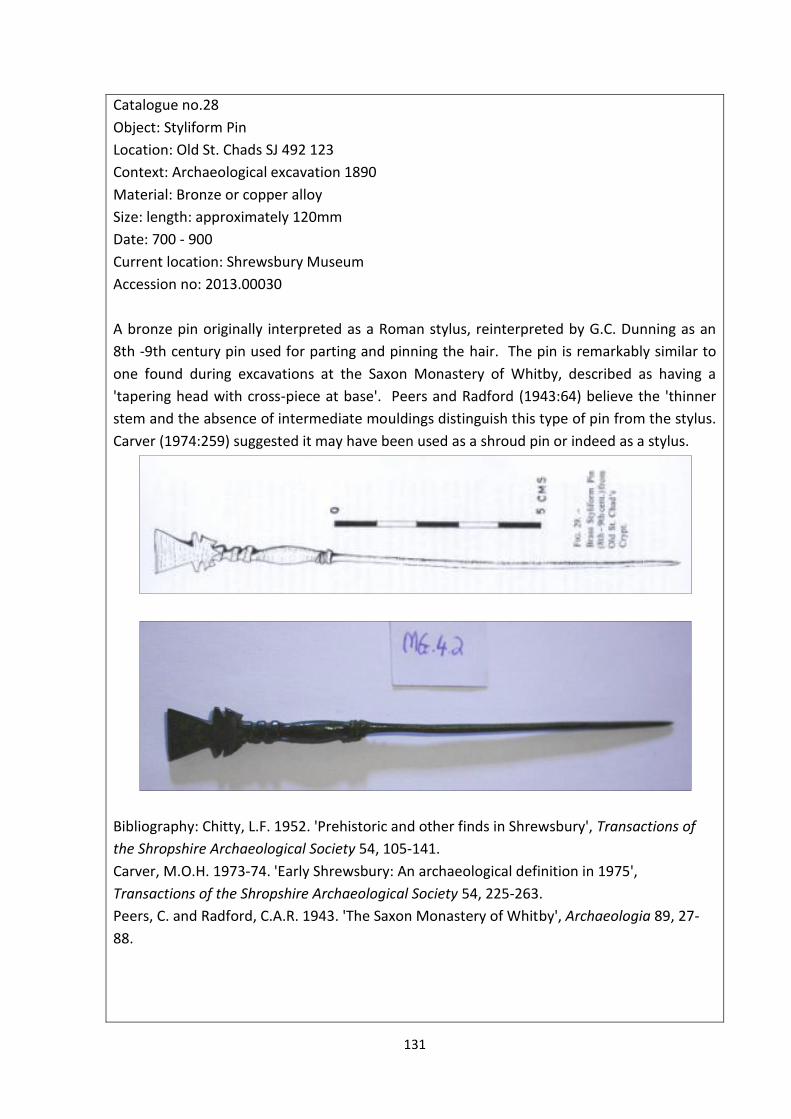
has been excavated and produced artefacts from the period. A pin or stylus (Catalogue no.
28) dated to the 8th – 9th centuries was discovered at Old St Chads and pottery has been
found at a total of 13 sites. With the exception of pottery sherds found at the abbey in the
eastern suburb, all other pieces were found within the river loop and demonstrate that the
extent of occupation was at least as extensive as that of the late medieval town (Baker,
2010:98-100). Just over half of the finds come from stratified contexts and although Stafford
ware pottery has generally been dated from the late eighth to the late eleventh centuries
Baker (2010:100) believes it was likely to have been used during the tenth and first half of
the eleventh century in Shrewsbury. Baker (2010:101) argues there is no evidence for town
planning as has been identified in Hereford and Worcester, except for the areas of Pride Hill
and Dogpole. Here houses had attended plots which ran down to the river and would have
provided land for animal husbandry which Carver (1983:42) believes would have taken place
on the peninsula.
Page 42
37
The other artefacts which could be associated with settlements contribute towards a picture
of domestic settlements which would have been familiar across Anglo-Saxon England. The
spindle whorl (Catalogue no. 32) would have been a common household object, but
although a practical functioning object, this example is decorated with incised lines and
circular indentations. The decoration is described as ‘crude’ (PAS) but displays a desire for
even common objects to be visibly attractive or perhaps personalised. Similarly the
furniture fitting (Catalogue no. 36) and handle mounts (Catalogue no’s. 37-40) are
decorative as well as functional. This suggests that whilst we do not have the physical
remains of the structures which comprised the homes of Anglo-Saxon people, it is possible
to suggest that settlements, or at least the objects used within them, may have been
decorative, individualised places.
Conclusion
The lack of specific dating material for Anglo-Saxon settlements does make it difficult to
establish a sequence of development in Shropshire. However we can see a system of small
dispersed settlements, many of which can be identified as early settlements through their
place-names, which continue throughout the Anglo-Saxon period to be recorded in the
Domesday Book. We can however plot the development of the formation of central places
as a need to display and establish new power regimes and as a response to the need for
greater defences against Viking attacks. The majority of the population would have farmed
the land as villeins or serfs for manorial lords. Within larger settlements, including the
county town, people would have lived a subsistence lifestyle, growing many of their own
plant food staples and rearing animals for meat and milk.
Page 43
38
The location, size and function of settlements was influenced in part, by the establishment
and expansion of the Roman Catholic Church throughout the Anglo-Saxon period. The
Church brought with it many changes to people’s lives, and the role of religion will be
explored in the next chapter.
Page 44
39
4.2 Religion
Religion played a key role in the transformation of Anglo-Saxon England. During the sub-
Roman period the west of England remained Christian whilst regions in the east, under the
influence of the incoming Germanic tribes became pagan (Gelling, 1992:95). Through the
seventh century missionaries from both Ireland and Rome once again spread the Christian
religion throughout England and Scotland. Many Anglo-Saxon kings converted to Christianity,
but Penda king of Mercia (626 – 655) remained pagan. When his son Wulfhere (658 – 675)
became king he became the first Christian King of Mercia. Continuing the practices of kings
elsewhere in the country Wulfhere began to endow monasteries, a practice which saw
Merewalh, a king of the Magonsaete who is believed to have converted to Christianity about
660, found the first English monastery in Shropshire at Much Wenlock in 680 with his
daughter Milburge in place as abbess (Gelling, 1992:95). There is little archaeological or
historical evidence for religious practices in Shropshire before the seventh century, however
following the conversion of Anglo-Saxon kings to Christianity and their patronage of the
Church evidence for religious practice begins to appear in the form of place-names, stone
buildings and sculptures, and objects bearing the symbol of the cross. The Church came to
dominate many aspects of people’s lives; they were often wealthy institutions with
members of royal families in senior positions. The construction of monastic sites would have
dramatically altered landscapes and the activities of the monastery would have generated a
need for workers, goods and markets more often associated with towns. The Roman Church
also brought with it literacy and although there are no surviving Church records from
Shropshire, monks such as the Venerable Bede did begin to record important religious and
Page 45
40
political events in Chronicles and Life stories which provide a detailed insight into the affairs
of Church and State during the Anglo-Saxon period.
The sources of data used to assess the religious character of Early Medieval Shropshire were
Anglo-Saxon Architecture (Taylor and Taylor, 1965), the Central Marches Historic Town
Survey (CMHTS), Domesday Book (Thorn and Thorn, 1986), the Corpus of Anglo-Saxon Stone
Sculpture (Bryant, 2012), place-name evidence (Gelling, 1990) and artefacts recorded with
the PAS and the HER.
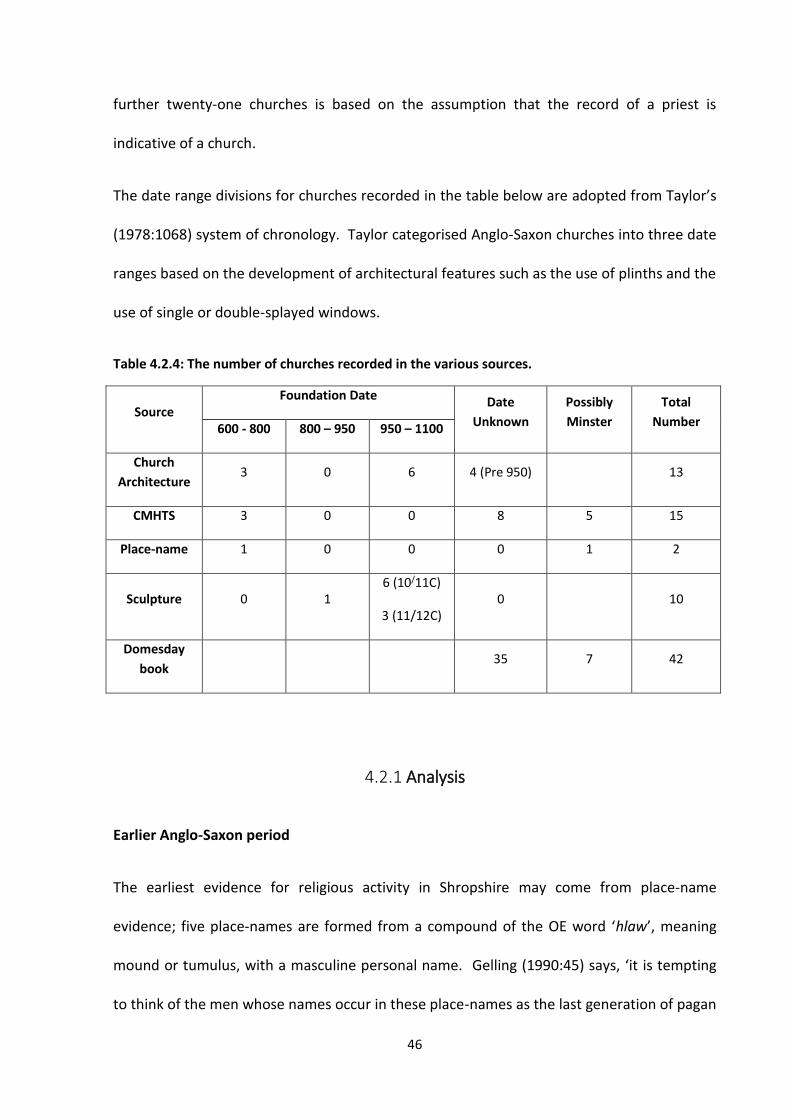
Domesday Book
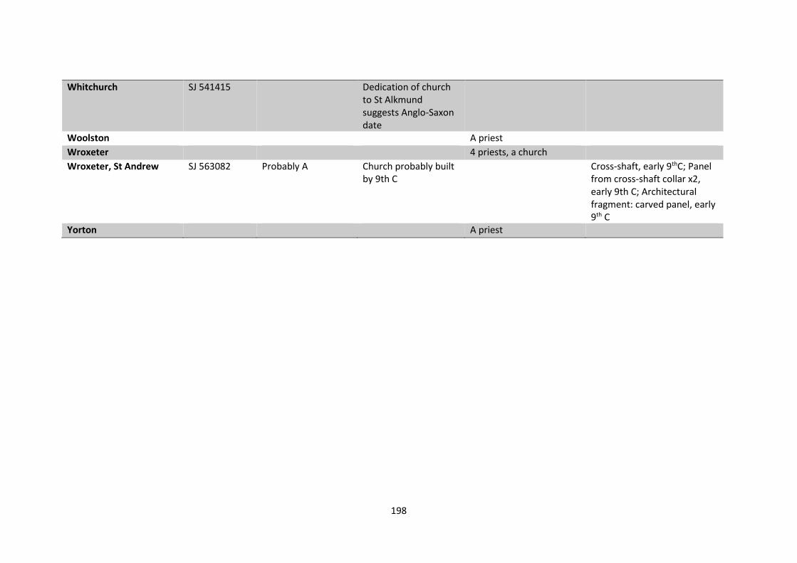
The Domesday Book records physical churches at twenty-one locations. However a further
seventeen locations are recorded as having ‘a priest’ and four entries record two or more
priests. Gelling (1990) believes that the identification of ‘a priest’ in Domesday indicates the
presence of a church and that two or more priests may indicate a minster, giving a total of
42 locations with a church in 1086. Bassett (1992:9) further argues there were some
locations for which neither a church or priest were recorded in Domesday but for which we
can still identify the presence of a church; Bassett (1992:9) cites the example of a probable
church at Upton Magna ‘shown by the gift of two-thirds of the tithes of Upton to the
Shrewsbury church of St. Peter & St. Paul before 1066’.
Place-names
The place-name evidence for churches is slight with only two place-names indicating the
presence of a church in the Anglo-Saxon period, Baschurch and Ellesmere. Seven place-
names indicate areas of land owned by the Church, including five Prestons, meaning ‘estate
of the priest’ (Gelling, 1990:242). Two place-names Wistanstow and Cressage are names
Page 46
41
associated with Christian ‘Holy places’. There are also five place-names related to ‘hlaw’, the
OE word meaning barrow or tumulus.
Church Architecture
A total of 13 churches have been identified through the remains of Anglo-Saxon architecture.
The church of St Milburga, Much Wenlock was perhaps the earliest foundation with
documentary sources confirming it was founded by St Milburga, the daughter of Merewald,
king of the Magonsaetan, in the later seventh century (Finberg, 1972:197). On the site now
are substantial remains of a later Norman abbey, but excavations by Cranage (1922:107) in
1901 revealed the remains of two earlier foundations, one of which was dated to the mid
eleventh century. The other, located in the centre of the abbey, was of a ‘confused layout’
(Taylor and Taylor, 1965a:454) but appeared to define a small rectangular building
approximately 11.6m x 8.5m. Cranage believed this to be the foundations of the original
seventh century church foundation although Woods (1987:58) has since argued the
evidence suggests an earlier Roman foundation on the site. Woods interpretation was
rebuked by Biddle and Kjolbye-Biddle (1988:181) who argue convincingly for an Anglo-Saxon
date for the foundation of Wenlock Priory.
The churches of St Eata, Atcham and St Andrew’s, Wroxeter contain building material reused
from the ruins of the Roman town Viroconium indicating an early date for the construction
of these churches. Taylor and Taylor (1965a:32) also believe St Eata to be of an early date
due to the characteristics of a triangular head of a north wall window and tall, thin walls.
The date of origin of St Andrew’s, Wroxeter is uncertain; the original north wall has a
horizontal string-course which is generally used to date churches to the later Anglo-Saxon
Page 47
42
period however Taylor and Taylor (1965b:695) have dated it to the earlier Anglo-Saxon
period on the basis of the original ‘simple’ window in the north wall.
Some of the churches of Shrewsbury are also thought to have an early foundation date in
the middle Saxon period, but the physical evidence is based primarily on observations made
during the course of works in the 19th century (Taylor and Taylor, 1965b:546). At St Mary’s,
earlier foundations were discovered below the nave which were interpreted by Archdeacon
Lloyd as an apse belonging to the original church and a nave (21m x 8m) dating to a period of
enlargement in the tenth century. Parts of the original fabric of St Alkmund’s and St Julian’s
are thought to have survived until the later eighteenth century when both churches were
rebuilt. A mid-Saxon styliform pin or stylus (Catalogue no. 28) was discovered in the original
church of St. Chad’s which partially collapsed in 1788. The church was subsequently
relocated to the north and east of the original church and rebuilt in 1793 (Baker, 2010:202).
Cranage dated the foundation of St Giles’, Barrow to the eighth century but Taylor and
Taylor (1965a:49) have ascribed it to the 10th century on the basis of a double-splayed
window and a pilaster strip on the north wall which are characteristic of this later period. St
Peter’s, Stanton Lacy is also dated to the later Anglo-Saxon period on the basis of pilaster
strips on the north and west walls of the nave and the north transept (Taylor and Taylor,
1965b:569). St Peter’s, Rushbury (Taylor and Taylor, 1965b:526) and St Peter’s, Diddlebury
(Taylor and Taylor, 1965a:211) have been dated to the pre-Conquest period based on other
characteristic features of later Anglo-Saxon churches. Herring-bone masonry is in the lower
section of the nave walls at Rushbury and can also be seen in the nave and west annexe at
Diddlebury which also has a later Anglo-Saxon double-splayed, round headed window. Both
churches and also St. Mary’s, Stottesdon (Taylor and Taylor, 1965b:580) have Norman period
Page 48
43
features which abut the original church fabric, further supporting the interpretation of the
original construction date as pre-Conquest.
Sculpture
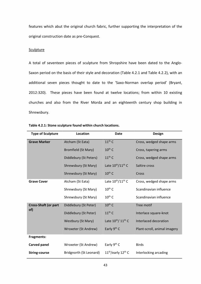
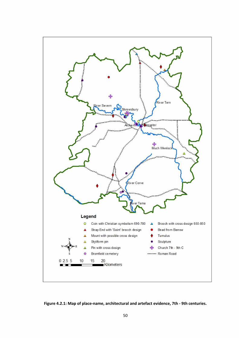
A total of seventeen pieces of sculpture from Shropshire have been dated to the Anglo-
Saxon period on the basis of their style and decoration (Table 4.2.1 and Table 4.2.2), with an
additional seven pieces thought to date to the ‘Saxo-Norman overlap period’ (Bryant,
2012:320). These pieces have been found at twelve locations; from within 10 existing
churches and also from the River Morda and an eighteenth century shop building in
Shrewsbury.
Table 4.2.1: Stone sculpture found within church locations.
Type of Sculpture Location Date Design
Grave Marker Atcham (St Eata)
Bromfield (St Mary)
Diddlebury (St Peters)
Shrewsbury (St Mary)
Shrewsbury (St Mary)
11th C
10th C
11th C
Late 10th/11th C
10th C
Cross, wedged shape arms
Cross, tapering arms
Cross, wedged shape arms
Saltire cross
Cross
Grave Cover Atcham (St Eata)
Shrewsbury (St Mary)
Shrewsbury (St Mary)
Late 10th/11th C
10th C
10th C
Cross, wedged shape arms
Scandinavian influence
Scandinavian influence
Cross-Shaft (or part of)
Diddlebury (St Peter)
Diddlebury (St Peter)
Westbury (St Mary)
Wroxeter (St Andrew)
10th C
11th C
Late 10th/ 11th C
Early 9th C
Tree motif
Interlace square-knot
Interlaced decoration
Plant-scroll, animal imagery
Fragments:
Carved panel
String-course
Wroxeter (St Andrew)
Bridgnorth (St Leonard)
Early 9th C
11th/early 12th C
Birds
Interlocking arcading
Page 49
44
Panel x3
Stanton Lacy (St Peter)
11th C Relief cross, slightly wedged shape arms
Figure carving Church Stretton (St Laurence)
11th C or earlier Figure, possibly Pan or fertility symbol
Table 4.2.2: Stone sculpture found outside church locations.
Type of Sculpture Location Date Design
Part of Cross-Shaft River Morda 10th/early 11th C Interlace pattern
String-course fragment Shrewsbury (Mardol)
x3
10th C Interlace decoration
Artefacts
A total of twenty-three objects, including seven coins, have been identified which can be
interpreted as having a religious association in terms of function or symbolism (Table 4.2.3).
Table 4.2.3: Artefacts with a religious association.
Object Location Date Religious Association
Amber bead Hoare Edge Anglo-Saxon Found within a Bronze Age Barrow
Sundial Holly Waste Anglo-Saxon Interpreted as a means of observing the
canonical hours
Spearhead Bromfield 410 – 800 Found within a Christian cemetery
Knife Bromfield 7th – 10th C Found within a Christian cemetery
Buckle Bromfield 7th – 10th C Found within a Christian cemetery
Brooch Whitchurch area 650 – 850 Central cross design
Pin Worfield 700 – 900 Vertical cross design
Styliform pin Shrewsbury, Old St.
Chads
700 – 900 Interpretations include a shroud pin or
stylus
Pendant Oswestry 700 – 1050 Image may represent a Norse God or
hero, the object may have been a good-
luck charm
Page 50
45
Furniture mount Market Drayton 700 – 1200 On the reverse of the object are incised
a vertical cross and a saltire cross,
interpreted as possibly representing a
Chi Rho symbol
Strap end Prees 9th C Design re-worked to depict a human
figure in the style of a ‘Saint brooch’
Disc brooch Shrewsbury 800 – 1000 Central vertical cross design
Harness fitting Oswestry 800 – 1100 Complex cross design
Stylus Whitchurch 800 - 1200 Cross hatching decoration, use as a
writing instrument
Staff terminal Hodnet 1000 - 1200 Interpreted as a terminal for an
ecclesiastical short staff
Hooked tag Norbury Parish Post 1016 Short cross design
Coin, Sceatta ? 690 – 700 Bird and cross design (forgery)
Coin Sheinton 786 – 809 Possibly Islamic design
Coin Wem 822 – 840 Contains the legend ‘Christiana religio’
Coin Oswestry 979 – 985 Depiction of the Hand of Providence and
A (alpha) and W (omega)
Coin Condover 979 – 985 Depiction of the Hand of Providence and
A (alpha) and W (omega)
Coin Whitchurch 1000 - 1010 Hiberno-Norse long cross design
Coin Sheinton 1050 - 1053 Short cross design
A total of 62 churches (Appendix 2) were identified across the county with only 11 of these
identified through multiple sources of evidence (Table 4.2.4). The source of data with the
most prolific evidence for churches is the Domesday Book. However there may have been
omissions from the Book and whilst the record does confirm the presence of twenty-one
physical churches it does not indicate the date of their foundation. The existence of a
Page 51
46
further twenty-one churches is based on the assumption that the record of a priest is
indicative of a church.
The date range divisions for churches recorded in the table below are adopted from Taylor’s
(1978:1068) system of chronology. Taylor categorised Anglo-Saxon churches into three date
ranges based on the development of architectural features such as the use of plinths and the
use of single or double-splayed windows.
Table 4.2.4: The number of churches recorded in the various sources.
Source Foundation Date Date
Unknown
Possibly
Minster
Total
Number 600 - 800 800 – 950 950 – 1100
Church
Architecture 3 0 6 4 (Pre 950) 13
CMHTS 3 0 0 8 5 15
Place-name 1 0 0 0 1 2
Sculpture 0 1 6 (10/11C)
3 (11/12C) 0 10
Domesday
book 35 7 42
4.2.1 Analysis
Earlier Anglo-Saxon period
The earliest evidence for religious activity in Shropshire may come from place-name
evidence; five place-names are formed from a compound of the OE word ‘hlaw’, meaning
mound or tumulus, with a masculine personal name. Gelling (1990:45) says, ‘it is tempting
to think of the men whose names occur in these place-names as the last generation of pagan
Page 52
47
Angles in Shropshire’. However there has been no excavation at any of these locations
which could test such a hypothesis, many of the sites have been damaged by ploughing and
at Whittingslow there is a quarry which has destroyed any potential archaeological evidence.
An amber bead (Catalogue no. 1) was discovered in a Bronze Age barrow on Hoare Edge at
some point before 1851, however there is no record of the discovery; it is first recorded by
the Secretary of the Society for Antiquaries in 1851 who believed it to be ‘Celtic’. The bead
was reclassified as Anglo-Saxon by Chitty (1934:111) due to its description as ‘large’. The
current location of the bead is unknown so it is not possible to carry out any further analysis
of the object. If the bead was from the Anglo-Saxon period and had been inserted into the
barrow as part of a burial ceremony, then, combined with the place-name evidence, it could
suggest that pagan burial practices were occurring in the area in the early Anglo-Saxon
period. These potential ‘pagan’ sites are located across the region, the bead was found in
the north-west and of the place-names one is located in the north-east, two in the central
belt and a further two sites are in the south-west. Bronze Age barrows and other existing
landscape features are known to have been used as important boundaries and meeting
places in the Anglo-Saxon period (Pantos, 2003:43). The distribution of the ‘hlaw’ sites
suggests this may have been their purpose and could have been the reason behind the
choice of place-name rather than indicating pagan burials.
There has been no definitive archaeological evidence for pagan burials within Shropshire;
the indigenous population remained Christian after the end of the Roman period and it is
generally assumed that Anglo-Saxons had converted to Christianity before they reached
Shropshire. However the discovery of furnished burials in what has been identified as a
seventh century Christian cemetery at Bromfield, north of Ludlow, has prompted debates
Page 53
48
about the religious practices conducted here. A total of 31 burials were discovered within
the cemetery, three of which contained grave goods (Stanford, 1985:4). Although grave-
goods are associated with pagan burial practices, the Church did not explicitly ban the use of
grave goods and the practice did continue into the seventh century, only really ceasing in the
eighth century (Owen-Crocker, 2004:26). A recent study into Anglo-Saxon burial practices
(Hines and Bayliss, 2013) has concluded that whilst the practice of using grave goods cannot
be used to distinguish pagan from Christian burials, the use of grave goods is a defining
characteristic of the ‘Early’ Anglo-Saxon Period (Hines et al, 2013:517)
The architectural and sculptural evidence suggests the earliest churches in Shropshire were
built in a corridor from Much Wenlock to Baschurch, bearing no relation to the location of
the barrow sites (Figure 4.2.1). The Church is known to have used earlier Roman and pagan
sites to construct its own ecclesiastical centres (Blair, 2005:65) and the lack of evidence for
this further suggests that the barrow sites were secular meeting places rather than places
associated with pagan practices. Much Wenlock was founded before 690 and Gelling
(1990:31) suggests the unusual inclusion of ‘church’ within the place-name of Baschurch, the
most north-westerly church site is a significant indicator of the early origin and hence
importance of a church at this location. St Andrew’s, Wroxeter is also thought to have had
an early foundation; stone sculpture dating to the early ninth century, the earliest in
Shropshire has been found here. The concentration of sites along the River Severn clusters
in Shrewsbury. This may illustrate the move of the capital of the Wreocensaete from
Wroxeter to Shrewsbury during the early Anglo-Saxon period and demonstrates the
importance of Shrewsbury as an ecclesiastical centre. Bassett (1991:3) argues that St Chad’s
is likely to have been the earliest of the churches in Shrewsbury, possibly an episcopal
Page 54
49
foundation in the middle Saxon period established as a see of the Wreocensaete. This was
closely followed by the royal foundation of St Mary’s when the region was absorbed by the
Mercian kingdom. The increasing number and the importance of the churches at Shrewsbury
throughout the Anglo-Saxon period demonstrates the increasing high status of the town.
Bassett (1991:11-13) believes St Alkmund’s and St Juliana’s were pre-Conquest royal
foundations established by the early ninth century, possibly part of an early minster complex
linked to St Mary’s. Bassett (1991:17) also argues that it is likely the churches of St Michael’s
and St Peter & St Paul’s were founded as minor minster churches also prior to the Norman
Conquest. Blair (2005:307) believes the foundation of a second minster church in many of
the main towns in Western England was part of a drive by Aethelflaed around A.D. 900 to
‘restore the prestige and efficacy of the Mercian Church’. St Mary’s was reconstituted by
King Edgar in the later tenth century and at some point became the senior church of
Shrewsbury (Bassett, 1991:8). The largest number of surviving grave covers and markers
from a single church are from St Mary’s which may also indicate its importance and status as
a senior church.
Page 55
50
Figure 4.2.1: Map of place-name, architectural and artefact evidence, 7th - 9th centuries.
Page 56
51
Place-names indicate other sites associated with Christianity for which we have no other
sources of evidence. Wistanstow means ‘the Holy place of St Wigstan’, who was a member
of the Mercian royal family murdered in 849 or 850 (Gelling, 1990:318). Wistanstow was
reported as the site of St Wigstan’s murder during the medieval period but Gelling (1990:318)
believes it was more likely to have been the site of a hermitage associated with St Wigstan
during his lifetime. Cressage meaning ‘Christ’s oak tree’ (Gelling, 1990:103), is located to the
south-east of Shrewsbury on the Bridgnorth to Shrewsbury road. Gelling (1990:103)
suggests this place-name may have originated from a tree located beside the road which
may have had a crucifix attached, identifying the settlement as Christian and providing an
edifice where travellers could stop and pray (Rumble, 2006:39). Wilks (1972:111) suggests
the symbolism of trees associated with pagan traditions were easily accommodated within
the new Christian religion through the ‘Tree of Life’ concept. Wilks (1972:111) states that
another oak tree at Bridgnorth, known as the Quatford Oak, was reputed to have been a
‘meeting place between Augustine and the Celtic Bishops of the older faith in A.D. 597’.
Again, place-names can provide unique insights into the beliefs and practices of people, and
the visibility of religious affiliation within the landscape; if crucifix’ or other symbols were
attached to trees it is likely they would have been made of wood and not have survived in
the archaeological record.
There are relatively few artefacts from Shropshire dating to the Anglo-Saxon period however
artefacts bearing Christian religious symbols do appear in Shropshire, as in the rest of
England, during the seventh century. Objects had a practical purpose but the forms of
decoration on them also conveyed powerful messages; ‘the cross as an object or gesture
was a powerful weapon taken from the liturgical arsenal of the church and applied to
Page 57
52
pragmatic concerns.’ (Jolly, 2006:58). A brooch (Catalogue no. 4) found in the Whitchurch
area has a typical design of a central cross, formed with five settings or cups which would
have held a gem or paste setting. An animal, probably a hound, is depicted in the panel in-
between the arms of the cross. The brooch demonstrates high quality workmanship and
had an applied gilt surface, a significant display of its value in the ninth century when gold on
brooches was rare due to a shortage in the supply of gold (Owen-Crocker, 2004:198). Dr
Kevin Leahy has suggested that ‘the object is of the ninth century Insular (Irish) metalwork,
brought to Shropshire under the aegis of the Vikings’. If this interpretation is correct then
this piece would demonstrate the presence of Scandinavians or contact with them at this
time. As this piece was found in the north of the county it could demonstrate a link with the
trading centre at Meols on the Wirral.
Also found in the north of the county was an unusual strap-end (Catalogue no. 67) dating to
the ninth century. This was another well-made object, made from silver and originally
decorated in Trewhiddle style with niello inlay, which was re-worked to depict a human
figure, possibly in imitation of a Germanic style ‘Saint’ brooch. A pin (Catalogue no. 27)
‘ornately decorated’ with a chip-carved vertical cross and interlocking scrolls was discovered
near Worfield, in the east of the county. During the seventh century, changes in artistic
design brought the pin to prominence as a ‘luxury’ decorative item of dress with the
cruciform design becoming fashionable during the eighth century (Owen Crocker, 2004:141).
The high quality of craftsmanship and materials involved in the creation of these objects
indicates that they were valued and valuable high-status pieces. The use of the cross symbol
and ‘saint’ depiction demonstrates the importance of the public display of religious belief
and affiliation to Christianity during the eighth and ninth centuries.
Page 58
53
As the Church spread across England so it brought with it literacy. In Old St. Chad’s,
Shrewsbury an object was discovered with a cross-piece at the base and has been
interpreted as either a hair or shroud pin or a stylus (Catalogue no. 28). The object is
remarkably similar to a pin found at the Saxon monastery at Whitby, suggesting a religious
association for this type of object. If the object is a hair pin it is further evidence of the use
of the cross as decoration on personal objects to display Christian beliefs. If it was a stylus, it
may well have been used in the creation of manuscripts within one of the religious houses in
Shrewsbury. Another stylus (Catalogue no. 34) was discovered near Whitchurch. The church
here is dedicated to St Alkmund which the CMHTS argue indicates an Anglo-Saxon
foundation, and could suggest a relationship with St Alkmund’s, Shrewsbury.
Later Anglo-Saxon period
The stone sculptures, which predominantly date to the tenth and early eleventh centuries
are associated either directly with the sites of minster churches or with their holdings (Figure
4.2.2). Exceptions are the fragment found in the River Morda but this is thought to have
originally come from St Chad’s, Shrewsbury, and the sculpture at St Leonard’s, Bridgnorth
which is from the Saxon-Norman period and likely to be post-Conquest (Bryant, 2012:320).
It is notable that surviving sculptures are also found predominantly near major river routes
(the Severn, the Corve and the Morda) with the exception of pieces identified at Westbury
which is located on a Roman road. This indicates that communication routes were
important factors in the choice of the location for establishing churches as is also seen in the
locations of early minsters in Northumbria and south-east England (Blair, 2005:150). The
presence of stone sculptures within minster churches is an indication of their wealth and
status. It is argued that the majority of churches were constructed of timber, only being
Page 59
54
rebuilt in stone after the Norman Conquest (Hooke, 2006:51) which explains the far greater
number of churches indicated in Domesday Book than we have material evidence for (Figure
4.2.2).
Shropshire has a diverse geology and it is likely the material for the majority of the stone
sculptures came from local resources (Bryant, 2012:35). The dating of stone sculpture is
difficult, it is often not precise and usually relies on other contextual evidence or engravings
(Cramp, 1991:xlvii). However the development and use of stone sculpture within Shropshire
can be seen as part of regional trends in the western midlands (Bryant, 2012). The cross-
shaft from St Andrew’s, Wroxeter is the earliest of the Anglo-Saxon sculptures from
Shropshire. This is the only sculpture in Shropshire made from oolitic limestone and to date
to before A.D. 900. There are many similar examples however of oolitic limestone
sculptures to the south and east in Hereford, Gloucestershire and Worcestershire suggesting
a relationship between Wroxeter and its southern neighbours in the earlier Anglo-Saxon
period. The St Andrew’s cross-shaft is decorated with a plant-scroll with leaves, berries and
fruit, and on a lower panel is a ‘deer-like creature’ (Bryant, 2012:314). Most of the remains
of the cross-shaft have been lost but are illustrated in drawings from the eighteenth century
which show one of the panels carved with a plant-scroll ‘inhabited with birds and animals’.
The design and decoration of the cross shaft indicate it may be part of the ‘Cropthorne’
group of carvings; a prestigious craft centre centred on Worcester (Bryant, 2012:67).
Page 60
55
Figure 4.2.2: Location map of churches and sculpture identified in Shropshire, A.D. 700-1066.
Page 61
56
Similarly to the cross-shaft from St Andrew’s, Wroxeter the cross-shaft from Diddlebury has
an elaborate tree scroll decoration incorporating human figures and fruit. Bryant (2012:307)
argues this could depict ordinary people frightening away birds from their ripening harvest
or be a reminder of the original sin of Adam and Eve getting the forbidden fruit. A deer is
depicted on the cross-shaft from St Andrews representing God, whilst another panel shows
three geese, birds associated with aggression pecking at snakes, a familiar representation of
Satan (Hicks, 1993). A grave-cover also from St Mary’s is decorated with an equal-arm cross,
to one side of which is a simple plant form with two buds at the top, on the other side is a
heavy, flat-bodied serpentine creature biting its own tail. Although the serpent is often
associated with the devil, within funerary contexts they can be illustrated biting their own
tails, forming a continuous circle, representing immortality and resurrection (Hicks, 1993:83).
The saltire cross carved on the grave-marker from St Mary’s, Shrewsbury may also represent
the ‘rising sun of resurrection’ (Bryant, 2012:309) reinforcing the message of salvation to be
found in Christianity.
Blair (2005:5) has argued that this ‘middle zone’, located between the Anglo-Saxons in the
East and the Britons in the West developed an insular art style that can be seen to have
multiple influences from within the British Isles and beyond. The section of cross-shaft found
in the River Morda was decorated with an interlace deign similar to that seen on several
sculptures from western Mercia and also from Wales (Bryant, 2012:308). The decoration on
the grave-marker and grave-cover found at St Eata, Atcham has parallels with regional styles
in Gloucestershire and further afield in the south-east of England (Bryant, 2012:305). Grave-
markers from Bromfield and St Mary’s, Shrewsbury are very similar in form and decoration
(Bryant, 2012: illustrations 542, 552) indicating they may have come from the same
Page 62
57
workshop and the calvary on which each cross stands displays influences from the north-
east sculptures of Northumberland and County Durham.
The cross-shaft from Westbury was decorated with an interlace design typical of west
Mercian sculpture, although Bryant (2012:314) has suggested the design could be
interpreted as a ‘free ring’ design indicating a Scandinavian influence. A grave-cover from St
Mary’s appears to be influenced from the Anglian tradition and is also similar to sculptures
found on the Isle of Man (Bryant, 2012:310). This may be a rare example of Scandinavian
artistic influence in Shropshire which could have originated either from the Isle of Man or a
Scandinavian colony in the Wirral established in the early tenth century. The decoration on
this cover consists of a cross and shaft with a plant engraving to one side and a serpent on
the other. Another grave-cover from St Mary’s also has a cross carving similar to that found
on tenth century crosses on the Isle of Man which reinforces the argument for a
Scandinavian influence from there.
As Hawkes (2003:27) has argued the form of many sculptures as a cross would have taken
this powerful Christian symbol outside of the confines of the church building and placed it
prominently and visibly within the landscape. The symbols and images depicted on stone
sculptures would also have had meanings which conveyed the beliefs and teachings of the
Church. Despite the range of influences which changed the style of sculptures, many
symbols such as snakes, deer, fish, birds and tree scrolls were used repeatedly throughout
the Anglo-Saxon period and their significance would have been understood by the people
who saw them (Hicks, 1993:26).
The small artefacts from Shropshire indicate that Christian symbolism was important in
people’s everyday lives; whether for personal worship or protection or to display to others a
Page 63
58
belief in Christianity. The cross would have been a visible, powerful symbol that would have
been seen not only fixed within the landscape on church buildings and in cemeteries, on
sculptures and on trees, but also as a portable symbol on personal items of clothing,
jewellery and on horse fittings such as that found in Oswestry.
A brooch (Catalogue no. 7) from Shrewsbury was decorated with a vertical cross. The
brooch was made from lead pewter, a trend which became popular in York workshops from
the late ninth century as a growing urban population demanded affordable jewellery
imitating that worn by the elite (Owen-Crocker, 2004:140). Nummular (coin) brooches were
also popular in the later Anglo-Saxon period, often exhibiting ‘rare and exotic connections’
(Owen-Crocker, 2004:207). A hooked tag (Catalogue no. 15) found near Norbury was made
by adding a hook to the obverse of coin so that the reverse, decorated with a saltire cross,
was displayed. It is possible that this style of jewellery was part of a fashionable trend but it
is also probable given the importance of the Church within society that the display of a
Christian symbol was of significance to the wearer.
The personal significance of the cross symbol can be illustrated by the furniture mount
(Catalogue no. 36) found in Market Drayton. The original object was created with ‘a great
deal of skill’ (PAS) but on the reverse were crudely carved a crucifix and saltire which have
been interpreted by the PAS as a possible attempt to depict the Chi Rho symbol. This would
not have been created for public display but to create an object of intimate meaning for the
owner. A silver strap end (Catalogue no. 67) discovered in Prees, also well made, had
originally been decorated in Trewhiddle style but was re-worked shortly after its initial
manufacture to depict a human figure; the result was an object which resembled the
German style ‘Saint’ brooch. This may have been used in a similar fashion to a pendant
Page 64
59
(Catalogue no. 19) found near Oswestry, again a re-worked object, originally decorated with
a figure leading a horse and used as a die for creating gold foil mounts. The piece was
clipped, redecorated with an incised bird and pierced to form a pendant. It has been
suggested by the PAS that the original figure may represent a hero or God from one of the
sagas and the object may have been worn as a good luck charm.
Conclusion
The collected evidence for religion in Shropshire shows the expansion of the Christian church
throughout the Anglo-Saxon period (Figure 4.2.3). The problems with accurately dating
sculpture and artefacts makes it difficult to interpret the rate of expansion and the effect the
arrival of the Church would have had on the people living in Shropshire. The construction of
all the churches indicated in Domesday Book may have occurred over several hundred years;
what can appear to be a dramatic transformation of the landscape from what we encounter
at AD 700 to AD 1066 may not have appeared particularly dramatic to people at the time.
However, we can say that during the period, Christianity and its symbols would have been
increasingly visible throughout the county. The discovery of many of the small finds in
locations not associated with settlements indicates that people were travelling around the
county and carrying symbols of Christianity with them.
The spread of the Church and the foundation of monasteries stimulated, contributed to and
influenced the economy of Shropshire throughout the Anglo-Saxon period. The
development of the economy will be the topic of the next chapter.
Page 65
60
Figure 4.2.1: Map of the collected evidence for religion in Shropshire, A.D. 700 – 1066.
Page 66
61
4.3 Economy
The decline of the Roman Empire brought about the decline of the network of trade routes
established and maintained by the Empire. The use of coinage ceased and in sub-Roman
and early Anglo-Saxon Britain it is thought that the economy was based on barter, gift
exchange and the exaction of tribute (Sawyer, 2013:31). The economy of England remained
closely related to and influenced by the economies on the Continent, in particular those of
Frisia and Germania. From the eighth century there was a general increase in the demand
for imported goods from the newly established monasteries and emerging market centres.
Fluctuations in the economy occurred frequently throughout the eighth to eleventh
centuries in response to Viking attacks and their demands for tribute, which reduced the
availability of silver but, Sawyer (2013:110) argues, by the eve of the Conquest England was
a prosperous country with a ‘remarkably sophisticated monetary control’.
The sources of data used to assess the economic character of Shropshire were the artefacts
and coins recorded by the PAS, the HER and Shrewsbury Museum, the database of the Early
Medieval Corpus of Coin Finds (EMC), place-name evidence (Gelling, 1990) and the Viking
and Anglo-Saxon Landscape and Economy (VASLE) project (Richards et al. 2009).
Artefacts
Excluding coins, 92 artefacts have been discovered in Shropshire which probably date to
between 600-1066, although some are possibly earlier. The majority of the artefacts have
been discovered by metal detectorists and therefore most of the objects are made of metal
which does present a bias in the record but still enables trends in the economy and wealth of
Shropshire to be identified (Figure 4.3.1). All objects would have to have been
Page 67
62
manufactured and as there is currently no archaeological evidence for metal working in
Shropshire, it is likely they would have been given as gifts, traded or sold and therefore
comprised part of the economy.
Figure 4.3.1: The number of objects made from different material types.
Ten of the objects have date ranges which cover the entire Anglo-Saxon period and are
therefore not particularly useful in analysing the temporal distribution of artefacts. Many of
the objects have forms and designs which were commonly used for centuries and so there is
an overlap in the period divisions (Table 4.3.1). However, as a general rule it is possible to
see that the number of objects dated to this period increase in the middle and later date
ranges. There are also three additional objects, two strap ends and a penannular brooch,
which were discovered during the Wroxeter Hinterland project but are not yet published
(pers. comm. Dr R. White).
3 4
62
8
47
3
0
10
20
30
40
50
60
70
Gold Silver Copper Alloy Lead Iron Ceramic Other
Nu
mb
er o
f O
bje
cts
Material
Page 68
63
Table 4.3.1: Date range of artefacts.
Date Range Number of Objects
Earlier (450 - 700) 9
Earlier – Middle (450 - 900) 5
Middle (700 - 900) 12
Middle – Later (700 - 1066) 22
Later (900 - 1066) 34
Coins
A total of nine coins (Catalogue nos. 81-90) from the Anglo-Saxon period have been
recorded by PAS and a further 39 are held at the Shrewsbury Museum and Art Gallery (Table
4.3.2). A hoard of approximately 200 coins was discovered in Shrewsbury during
construction work, however most of these were destroyed during the works and only six
now survive. Two pieces of Viking silver ingot are also held at the museum. Although a mint
was established in Shrewsbury by the early tenth century, none of the coins from this mint
have been found in Shropshire despite Sawyer’s (2013:91) suggestion that, with more than
five moneyers, Shrewsbury would have been one of the most productive mints during the
reign of Aethelstan (924-939).
The EMC database contains records of seven coins minted at Shrewsbury which have been
found elsewhere in England: one issued under Eadred (946-955) found in Wadborough,
Worcestershire; two issued under AEthelred II (978-1016), both found in Norfolk; one issued
under Cnut and found at Meols, the Wirral; and three issued under Edward the Confessor
(1042-1066) found in Newbury, West Berkshire and Nether Wallop, Hampshire, the find
location of the third is uncertain.
Page 69
64
Table 4.3.2: Anglo-Saxon coins found in Shropshire.
Coin Ruler Name / Type Date No.
Coin Base metal with pellet decoration 500 - 700 1
Silver Sceat Series E, possibly a Continental issue 675 – 750 1
Silver Sceat Series E (Variety G3) 680 - 710 1
Silver Sceat Forgery of Series B 690 - 700 1
Silver Penny Offa, King of Mercia 774 - 796 1
Silver Coin Arabic, Harum-al-Rashid 786 - 809 1
Denier Merovingian Francia, Louis the Pious 814 - 840 1
Silver Penny AEthelwulf, King of Wessex (New Portrait Issue) 839 - 856 1
Coin Edward the Elder 899 - 925 6
Silver Penny Eadred, King of All England 946 - 955 1
Silver Penny AEthelred II (the Unready), Coin of the Kings of All England, N
766 (First Hand)
979 – 985 3
Silver Penny AEthelred II (Long Cross) 978 - 1016 7
Silver Penny Aethelred II (Crux) 978 - 1016 1
Silver Penny AEthelred II (Small Crux) 978 - 1016 2
Silver Penny AEthelred II (Helmet) 978 - 1016 1
Silver Penny Hiberno-Norse (Long Cross) 1000 - 1010 1
Silver Penny Cnut (Pointed Helmet) 1016 - 1035 1
Silver Penny Harold I, Coin of the Kings of All England (Fleur-de-Lys) 1035 - 1040 1
Silver Penny Edward the Confessor, Coin of the Kings of All England, N 823
(Expanding Cross, Heavy)
1050 - 1053 1
Silver Penny Edward the Confessor (Pyramid) 1042 - 1066 7
Silver Penny Edward the Confessor (Hammer Cross) 1042 - 1066 4
Silver Penny Edward the Confessor (Small Cross) 1042 - 1066 2
Silver Penny Edward the Confessor (Sovereign/Eagles) 1042 - 1066 1
Silver Penny Harold II (PAX) 1066 1
Page 70
65
Place-name Evidence
There are numerous place-names which relate to the economic function of locations (Table
4.3.3). Within Shropshire there are place-names related to arable and pastoral farming, food
production, river transport and markets.
Table 4.3.3: Place-names related to economic function.
Place-name Meaning
Barlow Barley clearing
Berwick Grove Outlying or dependant farm
Bitterley Butter pasture
Cheswardine Cheese producing settlement
Eaton Control point for ferry or water transport
Eaton Constantine “
Eaton Mascott “
Eaton-under-Heywood “
Yeaton “
Middleton Settlement with a central function e.g. market-place
Middleton (in Chirbury Parish) “
Middleton (in Bitterley Parish) “
Middleton Scriven “
Ruyton of the Eleven Towns Rye Farm
Ryton Rye Farm
Shipley Sheep clearing or pasture
Shipton Sheep clearing or pasture
Smethcott Cottages of the smiths
Stottesdun ‘Horseman’s Hill’ where a man looked after a herd of horses
Welbatch Wheel stream – probably a mill wheel
Wigwig Probably ‘Wicga’s dairy farm’
Page 71
66
VASLE
The VASLE project examined the data derived from the vast increase in the number of
artefacts and coins which have been found by metal detectorists since 1997 and recorded by
PAS and the EMC. It has used this data to investigate the Anglo-Saxon and Viking economy
and landscape, 700 – 1000. The results of this study provide a context for the economy of
Shropshire during this period; the density of the distribution of artefacts and coins giving an
indication of the relationship between the economies of Shropshire and that of what
became England and Wales.
4.3.1 Analysis
Earlier Anglo-Saxon Period
The evidence for the economy of Shropshire during the earlier Anglo-Saxon period is sparse
(Figure 4.3.2). Gelling (1990:xv) argues that the time-scale of the transition from British to
English place-names is unknown and could have occurred throughout the period. It could be
assumed that the language of place-names changed whilst retaining the original meaning of
the name; this is by no means certain but does, perhaps conveniently provide a starting
point for exploring the economy of Shropshire. The place-name evidence we have related to
the economic functions of locations suggests the local economy was essentially based on
rural activities, with place-names referring to pastoral and arable farming activities or the
production of dairy foods associated with the keeping of livestock. From early documentary
sources and environmental archaeological evidence we know that wool was a valuable
commodity, exported from England and prized on the Continent (Hamerow, 2012:157). Two
Page 72
67
place-names refer to sheep farming and it is possible that these were associated with the
wool industry. Sawyer (2013:73) has suggested that the finds of ‘porcupine’ sceattas, found
in the east of England are representative of Frisian traders travelling to markets to buy wool.
The two genuine sceattas (Catalogue nos. 81-82) that have been found in Shropshire are
both porcupine types and whilst it would not seem logical for a Frisian trader to travel all the
way to Shropshire, it is conceivable that Shropshire wool was traded indirectly with Frisians
through the markets in eastern England.
Following the Roman withdrawal coins were not struck in Britain until c.650. In the earlier
Anglo-Saxon period there were only half a dozen or so mints, all located on or near the
eastern coast to take advantage of the continental trade (Blackburn, 1996:160). Very few
early coins have been found in western England and little can be said about the earliest coin
find from Shropshire and indeed, the identification of this object as a coin is questionable.
However the other coin (Catalogue no.83) from this early period, thought to be a
contemporary forgery, suggests that coins would have had considerable value, and also that
controls over the production of official coinage were in place in the eighth century.
Page 73
68
Figure 4.3.2: Map of evidence for the earlier Anglo-Saxon economy.
Page 74
69
The place-name evidence indicates three ‘central function’ places and four river-crossing or
control points. Three of the river-control points are located on tributaries of the River
Severn and the fourth is on a tributary of the River Corve. As the three main central places
of the Roman and Anglo-Saxon periods, Wroxeter, Atcham and Shrewsbury, were all located
on or near to the Severn it is likely that the river points could have been used at various
times to control the movement of people or goods into and out of these centres. A mill is
located on the River Corve and a central market location is also nearby. It is likely that rivers
would have served as quick and convenient routes to transport goods through the area.
The central places, which Gelling (1990:205) believes may have functioned as market sites,
are all in the south of the county, one in the west, one in the south and one in the south-east.
If these sites did have an early foundation as markets their location could be explained as
being within the northern borders of the territory of the Magonsaete and may have been
places where the people of the Magonsaete could trade with each other and with the
neighbouring people. All of the objects dating to this early period for which the find location
is known, have been discovered in the south of the county, with objects dating to the early-
middle period being more evenly distributed across the county. This may indicate that the
south of the county was the focus of trading activity in the sub-Roman and early Anglo-
Saxon periods, however three of the objects all come from the cemetery at Bromfield and on
the basis of such a small number of objects it is difficult to be confident of any interpretation.
Of the 92 artefacts recorded by PAS and the HER only nine can be dated securely to this
period, with a further five dating to the early – middle Anglo-Saxon period. However these
objects do indicate some form of exchange between Shropshire and areas in the east of
England, further supporting the idea of the movement of goods between Shropshire and the
Page 75
70
Continent via markets in eastern England. Gold was used in the manufacture of objects
primarily in the earlier Anglo-Saxon period, particularly the late sixth and seventh centuries
when supplies from Byzantium via Merovingian kings and south-east England, were still
available (Leahy, 2003:153). All three gold items from Shropshire are dated to this period.
The gold ring (Catalogue no. 20) found in South Shropshire is unusual and, as a parallel is
unknown, it’s dating is questionable. However a pendant and pommel held by Shropshire
Museum Services are classic examples of early Anglo-Saxon gold and garnet work.
Shropshire Museum Services have suggested that the gold pendant, dated to the early
seventh century, may have been part of a dowry or gift in a marriage alliance between elite
families in the Shropshire region and Kent, or that it may have been looted by the armies of
Mercia during its expansion in the later seventh century when client kings were established
in Kent. Whatever their origins these pieces indicate that there were wealthy and powerful
people in Shropshire with the ability to acquire high status gold objects. Sawyer (2013:53)
has argued that the value of gold would have meant great care would have been taken not
to lose gold objects and efforts made to retrieve those which had been lost. With this in
mind, it is possible to suggest that there would have been many more gold objects
circulating in Shropshire and the three which have been recovered are the results of
accidental losses which the owners were unable to retrieve. A bead (Catalogue no. 2) found
near Clun was made from Whitby jet and may also represent trade, gift exchange or tribute
between Shropshire and the north-east of England.
Viking Period
There is an increase in the number of artefacts that have been found dating to after c.800
compared to the earlier period. Eight artefacts have been identified as being of
Page 76
71
Scandinavian manufacture or design influence. With the exception of a strap end (Catalogue
no. 74) found in Stowe, all of these objects have been found to the north and east of the
River Severn (Figure 4.3.3). The distribution of the artefacts suggests that for some reason,
Scandinavians, or their goods, rarely passed to the south and west of the Severn.
The distribution could suggest that objects were coming into Shropshire from the coastal
market site of Meols on the Wirral. This site has now been extensively studied and found to
have been the site of a trading port possibly originating in the Iron Age and continuing into
the later medieval period. Activity at the site seems to have declined during the earlier
Anglo-Saxon period increasing again from the tenth century (Griffiths, 2007b:402). Over 100
Anglo-Saxon period objects have been discovered at Meols, making it probably the densest
concentration of Anglo-Saxon finds in the west of England (excluding hoards) and gives a
good indication of the type of objects that were being traded (Griffiths, 2007a:58). The
majority of finds from the site are a range of dress accessories. Also found were domestic
and agricultural tools and implements, horse equipment and a scale attachment associated
with the activities of trade (Griffiths, 2003a:61-71). A significant number of the Meols finds
from this period, including pins, strap ends and hooked tags are similar to those discovered
in Shropshire. Leahy (PAS website) believes a highly ornate and crafted disc mount brooch
(Catalogue no. 4) discovered near Whitchurch was made in Ireland and brought to
Shropshire by the Vikings. These objects demonstrate that there was some form of contact
between Scandinavians, possibly coming to England from Ireland, and the people of
Shropshire. However whether these objects were part of an active trade or were lost by
Scandinavians passing through the region is unknown.
Page 77
72
Figure 4.3.3: Location map of artefacts with Scandinavian influence.
Page 78
73
An Arabic coin (Catalogue no. 84) has been discovered to the north of Much Wenlock, on the
River Severn. This coin and two pieces of bars of silver ingot (held by the Shropshire
Museum Services) are again associated with ‘Viking’ trade and suggests that trade of some
form was occurring here.
Later Anglo-Saxon Period
In the later Anglo-Saxon period the use of coins increased as the introduction of silver
coinage meant that coinage could be used in less valuable transactions than the gold coinage
of the earlier period. By the 920s there were 35 – 40 mints in England, established by Alfred
(871-99) and Edward the Elder (899-924), which were all located within burhs, a royal policy
which continued through the period. The date of the establishment of the mint in
Shrewsbury is unknown but coins were minted here during the reign of Aethelstan (925-39)
and Baker (2010:98) argues that the space between the churches of St Alkmund’s and St
Juliana’s may have been a market place from the early tenth century. None of the
Shrewsbury coins have been found within Shropshire although the EMC database records
seven coins minted at Shrewsbury, the location of one find is uncertain but two were found
in Eastern England, two in southern England and two closer to Shropshire, one in
Worcestershire and one in the Wirral. The coins date from 946 – 1066 indicating that trade
was being conducted between Shropshire and regions across England during this time.
The find spot location for the coins held by Shropshire Museums are not known, but the
distribution of the coins which have been found in Shropshire and recorded by PAS do show
a pattern (Figure 4.3.4). It can be seen that they are located within a corridor of the River
Severn and in the north of the county, possibly showing a route which could have been used
by those travelling from the Wirral through northern Shropshire to Shrewsbury. The
Page 79
74
distribution pattern of the coins could possibly indicate the extent of an area in which there
were Scandinavian cultural influences and economic activity between Scandinavians and the
inhabitants of Shropshire. It is likely this indicates an active economic relationship between
Scandinavians and the diocese of Lichfield which included the northern and eastern half of
Shropshire, discussed further below.
The general distribution pattern of artefact finds from the Middle – Later Anglo-Saxon
periods show a similar distribution to that of the coins (Figure 4.3.5) with the vast majority of
objects being found in Shrewsbury and to the north and east of the River Severn. Clusters of
finds occur in Shrewsbury, Oswestry in the north-west, Whitchurch and Prees in the north,
and Worfield and Claverly in the east-south-east. The clustering may in part be subject to
the locations in which metal detectorists are active but as a number of single finds have also
been made, especially in the east of the county, the clusters could indicate areas which were
repeatedly used as meeting or trading sites. Many of the single finds in the east are located
near to the main Roman road which connected the region with London and may be the
result of the casual losses of travellers. The majority of the pottery which has been
identified from Shrewsbury is Stafford ware which also indicates trade with regions to the
east of the county.
From the analysis of PAS finds conducted by VASLE we can see a national pattern of finds
indicating a far greater level of trade and use of metal objects in the eastern half of England
than in the west (Figure 4.3.6). However there is a general increase in finds from the later
period compared to the earlier period across England. Shropshire, despite not being as
wealthy as areas in Eastern England, does appear to fit into this pattern of greater prosperity,
wealth and trade.
Page 80
75
Figure 4.3.4: Location map of coins.
Page 81
76
Figure 4.3.5: Location map of mid-later Anglo-Saxon artefacts.
Page 82
77
Figure 4.3.6: Location map of PAS Early Medieval finds (http://intarch.ac.uk/journal/issue25/2/2.5.1.html).
From this later period we can see a general increase in the display of wealth through an
increase in the occurrence of finds such as a variety of horse fittings (Catalogue nos. 51-63)
and strap ends (Catalogue nos. 64-78). Most of these objects were made of copper alloy,
not as expensive as gold or silver, but many were elaborately decorated and the ownership
of a horse itself was a significant symbol of wealth and status. The objects from Shropshire
follow a trend identified in York, in which an increasingly successful merchant class wished
Page 83
78
to emulate the objects worn by the elite and so copper-alloy objects were made which could
be afforded by this new class of people. The increasing number of these types of finds in
Shropshire suggests that, as elsewhere in England, there was an increasing amount of wealth
and trade in Shropshire during the later Anglo-Saxon period.
Conclusion
The combined data suggests that during the earlier Anglo-Saxon period trade and also
wealth were predominantly to be found in the southern half of the county, within an area
which would have been within the northern territory of the Magonsaete. Due to the
combination of multiple factors; integration of the area within Mercia, the founding of the
Minster at Much Wenlock in the early eighth century and the development of Shrewsbury as
the main commercial centre by the late ninth century, coupled with the arrival of new
avenues of trade with Scandinavians from the north of the region, the signs of trade and
economic prosperity move to the central and northern areas of the county. Despite the
relative lack of urbanisation and wealth in Shropshire compared to areas in the east of
England the general pattern of increasing material objects and coinage in the later period
corresponds with a general increase in wealth and a successful trading economy in England
from the tenth century.
Page 84
79
5 Discussion
The VASLE project has demonstrated that the number of Anglo-Saxon artefacts discovered in
West Central England is considerably lower than the numbers found in eastern regions,
although comparable with finds from the northern region (Figure 5.1). However as Hines
(2002:2) commented, the increase in recorded finds from PAS and the integration of
historical and place-name evidence with archaeological evidence means archaeologists can
be ‘positive’ about researching the Anglo-Saxon period in the West Midlands region. By
drawing together the data analysis from the three previous sections it is possible to begin to
discuss the development of Shropshire through the Anglo-Saxon period.
Figure 5.1: The numbers of Anglo-Saxon artefacts recorded by PAS for English regions.
Earlier Anglo-Saxon Period
The evidence we have for the earlier Anglo-Saxon period is largely inferred from place-
names and a relatively low number of artefact finds. The number and extent of settlements
420 457
21652348
1357
1220
500
1000
1500
2000
2500
WestCentral
Northern EastCentral &
Lincs
East Anglia South-east South-west
Nu
mb
er
of
Art
efa
cts
English Region
Page 85
80
in Shropshire during this period is unknown, however we do know that the Roman town at
Wroxeter continued in some form of use until the sixth or seventh century (White et al.
2013:198). The artefact and place-name evidence suggests that there were two main
centres of activity; one centred around the junction of the rivers Teme and Corve in the
territory of the Magonsaete, and the other centred near Wroxeter, around the junction of
the rivers Severn and Tern in the territory of the Wreocensaete (Figure 5.2). The movement
of the Anglo-Saxons, from the east into the western regions of Britain during this earlier
period resulted in cultural, political, religious and economic changes altering the landscape
and affecting people’s daily lives.
The earliest artefacts all come from the southern half of Shropshire and place-names
indicate farming activity and ‘market’ centres were also located predominantly in the south
of the county during this period (Figure 5.2). It is likely that there was a subsistence
economy with the majority of the population living in dispersed rural settlements, growing
wheat and rye crops or rearing sheep, cattle or horses. Enough surplus must have been
produced to warrant the creation and use of regular market sites and to support an elite.
The presence of an elite is supported by high status finds; gold objects originating from the
east of England. All of those with known location recordings have been discovered in the
territory of the Magonsaete. The inclusion of grave goods in only three burials in the
cemetery at Bromfield also suggests there was an elite in the area around Ludlow. A recent
study by Bayliss et al. (2013:524) has shown that unfurnished inhumation was the norm in
western England and Wales from the post-Roman period through the Anglo-Saxon period.
Furnished inhumations became associated with Anglo-Saxon burials from the later fourth
century in eastern England, a practice which ended by the later sixth century. However the
Page 86
81
authors argue that the use of grave goods cannot be used to identify religious belief as by
the end of the furnished burial phase, objects were also placed in Christian graves, including
that of St. Cuthbert (Bayliss et al. 2013:526). The deposition of valuable items in graves is
therefore more likely to demonstrate a display of the wealth or prestige of those conducting
the burial. The inclusion of three furnished burials within an otherwise Christian cemetery
suggests that the use of grave goods was an acceptable practice by the Christian community
at Bromfield and that the use of grave goods was employed to mark out these individuals as
different from the rest of the community.
The evidence suggests that in the early Anglo-Saxon period there was an organised,
hierarchical society in the south of the county, possibly within the Magonsaete territory,
who lived in dispersed settlements, practised Christianity and who had an organised
economic system based around the local markets. The likely use of tumuli as meeting
locations suggests there was a formal system for debate and the dealing of dispute, which
also suggests a politically or ‘legally’ organised society.
The subjugation of the Magonsaete and Wrocensaete territories by Mercia during the
seventh century may be evidenced by a shift in activity within the region which appears to
have increased around the Severn, whilst declining in the southern half of the county. The
arrival of the Anglo-Saxon Church would also have had a considerable impact on the
settlement and economy of the region. Walker (2000:164) has argued that it is possible that
the reforms which led to the creation of shires may have been initiated earlier than is often
thought, by Mercian rulers and not by the later West Saxon rulers. Although the shire units
were designed to bring a form of stability and create a bond within the population to their
Mercian overlords (Walker, 2000:165), it is likely that the tribal allegiances of the
Page 87
82
Magonsaete and the Wrocensaete were maintained to some degree. Kirby has described
the Magonsaete as a ‘satellite folk group’ (1977:35) of Mercia who continued to be in
conflict with the kingdom of Erging, south of Herefordshire. Penda (634-56) forged an
alliance with the Britons of Wales and it was not until the reign of his son, Wulfhere (659-75)
that conflict arose between Mercia and Powys.
The ‘byrig’ place-name evidence suggests the location of the forts and fort-guardians are,
with the exception of the fort at Baschurch, all located to the south of the River Severn. The
location of three of the forts, to the south of Atcham and Much Wenlock, suggests that the
forts were built after the palace and minster had been constructed respectively at these
locations. The fort at Baschurch is located on the southern end of a ridge, the first point of
high land to the north of Shrewsbury. Although the fort is approximately 10km from
Shrewsbury, its location on a ridge means it may have been positioned as an initial defensive
or look-out post for Shrewsbury. Another fort was constructed on the Shropshire – Powys
border near to the relatively large settlement of Lydbury North. The use of English place-
names and the locations of the forts suggest that they were built in the latter half of the
seventh century when Mercia was in conflict with Powys.
Page 88
83
Figure 5.2: Map of evidence from the earlier Anglo-Saxon period.
Page 89
84
The evidence for the forts plus a strong possibility of an Anglo-Saxon palace site at Atcham
coupled with the foundation of the minster at Much Wenlock before 690 suggests the
display of a consolidated political and religious power base in this area in the second half of
the seventh century. Combined with the establishment of the earliest churches along the
River Severn and the founding of Shrewsbury at some point during the ninth century it
becomes clear that this area became the central power base for the region following the
absorption of the area into the Mercian kingdom. Although few artefacts date to this early –
mid period there is a general pattern of artefact discovery locations also moving away from
the south of the county towards the central and northern areas during this time. This could
suggest a fundamental change in the power base and relationships between social groupings
when the Mercian kingdom subjugated the territories of the Magonsaete and the
Wreocensaete.
Many minsters were founded by secular royal families from the later seventh century with
the result that the political, social and economic power of the Church increased (Blair,
2005:84). This is seen in Shropshire with the founding of Much Wenlock and the
construction of stone churches. The use of stone sculpture in the early ninth century at St
Andrew’s, Wroxeter demonstrates that there was an elite who founded or donated to this
Church, and used their wealth to ensure their closeness to God and to publicly display their
devotion to the Christian Church. The development and construction of churches,
particularly those constructed of stone, would have had a significant physical and visual
impact on the landscape (Blair, 2011:732). To what extent the initial spread of the Anglo-
Saxon Church would have affected the local population is debateable. It is likely however
that the church would have impacted not only on the religious life of communities but also
Page 90
85
on the settlement and economy of the surrounding area. Many churches were endowed
with land from which to gain revenue and it is likely that by the middle Anglo-Saxon period
the arrival of the Church would have stimulated the need for labourers, produce markets
and settlement clusters which had not previously existed.
Middle – Later Anglo-Saxon period
The influence of the Vikings is clearly seen in Shropshire from the early ninth century
onwards. From this period it is possible to see a far greater number of artefacts have been
recovered from the north and east of Shropshire than from the south and west. No longer is
the predominating cultural influence in Shropshire coming from the east and the Anglo-
Saxons, but from Scandinavians arriving to the north of the region. Artefacts originating
from Ireland, often with a Scandinavian artistic style have been discovered at the site of a
beach market located at Meols on the Wirral, where following a decline, activity increased
again from the middle Anglo-Saxon period. The artefacts found in Shropshire which have a
Scandinavian influence have been found to the north of the River Severn, with only one
exception, making it probable that Scandinavians were trading with people in this area or
moving through the northern half of Shropshire, possibly from Meols to the Danelaw. This
could suggest that Scandinavians had different relationships with people in the north and
east of the county to those living in the south and west. It is interesting to note the locations
of the fortifications constructed by Aethelflaed in the beginning of the tenth century. These
forts are recorded as being constructed in direct response to Viking raids and are located at
the central settlement of Shrewsbury and two additional sites, Bridgnorth and Chirbury,
both in the south of the county. Attacks on Shrewsbury could indicate changing relations
between the Vikings and English, but the location of the forts in the south contrasts with
Page 91
86
evidence for trade in the north possibly suggesting that territory south of the Severn was
more hostile to Scandinavian traders or more vulnerable to attack from Scandinavian raiders.
The Church may also have played a role in these differing relations; the north and east of
Shropshire (the region of the Wrocensaete) were part of the diocese of Lichfield whilst the
south and west (the region of the Magonsaete) were part of Hereford diocese (Gelling,
1992:98). By placing the evidence into a regional setting it is possible to see that Lichfield,
located near to the border of the Danelaw, had a more proactive cultural and economic
relationship with Scandinavians than people in the diocese of Hereford (Figure 5.3).
From the artefacts we can see that people in Shropshire were trading not only dress
accessories with Scandinavians from Meols but also with the Staffordshire ceramic industries.
The distribution of coins found across England which were minted at Shrewsbury and the
origins of the coins found in Shropshire also indicate trade was continuing between
Shropshire and southern regions of England. It is also possible to see economic influences
from the Danelaw. The use of particular materials for objects follows the national pattern at
the end of the seventh century in a decline in the use of gold, with elite objects instead being
made of silver with niello decoration. During the ninth century we again see a change in the
material of objects with the introduction of lead or pewter objects; a fashion which appears
to have started in York as a general increase in prosperity resulted in a new class of people
wishing to emulate the styles of the elite in an affordable manner.
Page 92
87
Figure 5.3: Location of Shropshire in relation to the Diocese of Lichfield and the Danelaw.
Page 93
88
Figure 5.4: Map of evidence from the mid-later Anglo-Saxon period.
Page 94
89
Generally the increase in the number of finds from this period in comparison with the earlier
period may reflect a greater level of wealth and improved economy (Figure 5.4). It may also
be the case that status or wealth were displayed in differing ways during the earlier period
but in this later period there appears to be a desire for those in positions of power or wealth
to display their status through material objects, particularly portable objects such as dress
and horse fittings which would have been clearly visible to people seeing these individuals.
Increased trade with Scandinavians bringing new styles of Scandinavian and Irish objects into
the area may also have stimulated a new, or different, consumer society. Many of the
objects from this period have been decorated with Christian symbols and imagery indicating
that it was also important to people to display their belief in or affiliation with the Church.
Many of the finds have been found in relative close proximity to others, particularly within
Shrewsbury, and within clusters on the Roman roads which run from the north of the county
towards Wroxeter, the road from Wroxeter running south-east, the road in the north-west
of the county and an area in the south of the county on the River Corve. These clusters may
indicate settlements, meeting places or markets where people would have regularly
gathered, thereby increasing the likelihood of a greater number of objects being lost within
the area. In contrast, the individual scattered finds may represent areas through which
people travelled between locations and lost objects in more isolated places.
It is also during the ninth and tenth centuries that we have evidence for an increase in the
number of stone churches being constructed and stone sculptures being made. This also
suggests an increase in wealth in the area which may also have resulted in an increase in
Viking attacks. Following on from the initial location of churches along the River Severn, the
location of these later stone churches is focused on the south-east of the county. The only
Page 95
90
evidence for stone built churches in the west of the county from this period are two cross
shafts, one found at St May’s, Westbury and the other found in the River Morda. The
increase in the construction of churches from the tenth century probably reflects the
fragmentation of large estates into smaller units within which new manorial lords
established their own churches (Hooke, 2005:165).
Hooke (2005:165) argues that the break-up of large ecclesiastical and secular estates would
have also impacted on local economies, societies and the political framework across England.
The gathering of tribute as had occurred under the large estates was replaced by the
rendering of services and money, raised from individual estates. In rural areas with low
populations such as Shropshire, it is thought that an infield-outfield system of farming
developed as opposed to the open field system which developed in more densely populated
areas (Hooke, 2005:169). This resulted in the continuation of smaller dispersed settlements
as is reflected in the accounts of the Domesday survey for Shropshire.
The End of the Anglo-Saxon period
The Domesday Survey of 1086 provides an insight into the settlement pattern, population,
number of churches and the value of landholdings and taxes shortly after the Norman
Conquest. Many people and places would have been affected by the Conquest, the cultural,
political and economic influences on the region once again coming from invaders pushing
from the east into the west. Subsequently there were new divisions and owners of land,
however as the new Norman lords were to hold the same responsibilities as well as rights as
their English predecessors (Williams, 1977:51) it is likely that the picture of the general
population we get from Domesday is similar to that before the Conquest.
Page 96
91
Figure 5.5: Map of evidence from the end of the Anglo-Saxon period.
Page 97
92
From the Domesday account for Shropshire we can see a county towards the end of the
eleventh century comprised primarily of small scattered settlements, the majority with
fewer than five households, with populations who were economically tied to the estate on
which they lived and worked. The number of burgesses recorded in Domesday for
Shrewsbury along with the multiple churches and the mint demonstrate the development
and importance of this town through the later Anglo-Saxon period. Most of the smaller
settlements appear to be scattered across the county, but we can see that many of the
larger settlements, the churches recorded in Domesday and many of the artefacts recorded
by PAS are located on or near to the routes of Roman roads illustrating that these remained
important communication routes throughout the Anglo-Saxon period (Figure 5.5).
There is still much to be learnt about the detail of political, social, religious and economic
developments in Shropshire during the Anglo-Saxon period. However the compilation and
analysis of evidence from various sources has shown that Shropshire was not an isolated
region. It was connected to other regions throughout England, Ireland and Wales and
through trade with these regions was also connected to the worlds of the Continent and
Scandinavia. The people of Shropshire would have been affected by the spread of the
Church, the Viking raids, the Norman Conquest, economic fluctuations and developments of
urbanisation as people were across all of England.
Page 98
93
6 Conclusion
This study has focused on the use of combining multiple sources of data to investigate the
character of Shropshire A.D. 600 – 1066. The findings demonstrate that throughout the
Anglo-Saxon period Shropshire was a highly active, evolving and integrated part of England.
It did not have a central economic, political or religious role as seen in Southampton, York or
Canterbury, but the people of Shropshire were engaged with, influenced and affected by the
events and trends that occurred across England.
Much of the general literature on Anglo-Saxon England focuses primarily on eastern regions
of England. Whilst there is a valuable range of literature on western England, in particular
the kingdom of Mercia, these sources also generally focus on the geographical or thematic
areas for which there is the greatest amount of evidence. Whilst there is relatively little
archaeological evidence from Shropshire dated to the Anglo-Saxon period, this study has
sought to address the current gap in knowledge about Anglo-Saxon Shropshire by combining
multiple sources of data to create an overview of Shropshire through the Anglo-Saxon period.
This study has looked at three specific thematic areas; religion, settlement and the economy,
before integrating these themes in the discussion chapter to develop a broad character
assessment for Shropshire.
This method has brought to light new insights into this period. Primarily, the artefact
evidence demonstrates the changing frontiers or zones of cultural contact and influence in
the county; in the 5th – 7th centuries a border ran north-south as the Anglo-Saxon influence
came into the west from the east. Then, through the 10th and 11th centuries the frontier ran
along the river Severn as contact with Scandinavians arriving across the Irish Sea became a
Page 99
94
dominant cultural influence, and then following the Norman Conquest, the north – south
frontier returned as the Normans moved from east to west.
The limit of Scandinavian contact or influence is demonstrated in the apparent differences in
the trade and economies of the region to the north and east of the River Severn in
comparison with the region to the south and west of the Severn. This could suggest that
tribal affiliations within the Magonsaete and Wrocensaete continued into the later Anglo-
Saxon period, governing the relationship between the peoples of the two regions and the
Scandinavians. The inclusion of the region of the Wrocensaete in the diocese of Lichfield
and the region of the Magonsaete within the diocese of Hereford may also have resulted in
differing trade and cultural contact with the Scandinavians. Given the relative scarcity of
artefacts from Shropshire, the proportion of those with Scandinavian or Irish origin or
influence is surprisingly high. No Scandinavian settlements have been discovered in
Shropshire but the high proportion of artefacts does indicate a considerable presence, which
could be explored in future studies.
This study has demonstrated that combining data for PAS finds from Shropshire with
multiple other sources can make a valuable contribution to our knowledge of the county
during the Anglo-Saxon period. The contribution of the PAS database will continue to
increase in value as more artefacts are discovered and recorded. However restrictions on
access to the find location information for some of the objects may have influenced the
results of this current research which may have been particularly relevant when making
interpretations based on such a low total number of artefacts. Aerial photography is
another avenue of exploration which may reveal other potential Anglo-Saxon sites such as
Page 100
95
the possible palace site identified at Atchem, which if excavated, could vastly improve our
current state of knowledge.
This study has produced an over-view of Anglo-Saxon Shropshire, the results of which have
the potential to be incorporated into a larger study on western Anglo-Saxon England.
Combined with studies from other western counties, issues such as the extent of
Scandinavian contact and influence, the wider regional economy and the expression of
identity in the border region could be addressed. Such studies could then be used to create
both a broader and more subtle body of information and go some way towards balancing
our knowledge of eastern and western England during the Anglo-Saxon period.
Page 101
96
Bibliography
Primary Sources
Anglo-Saxon Chronicle, trans. and ed. M. Swanton (London 2000).
Bede, The Ecclesiastical History of the English People, trans. P. Hereford (London, 1935).
Domesday Book, F. Thorn and C. Thorn (eds), trans. C. Parker (Chichester, 1986).
Secondary Sources
Baker, N.J. 1983. ‘Dating the Sequence’, in M.O.H. Carver (ed.), Two Town Houses in
Medieval Shrewsbury, Transactions of the Shropshire Archaeological Society 61, Gloucester,
63-64.
Baker, N. 2010. Shrewsbury: an archaeological assessment of an English border town, Oxford.
Barker, P., White, R., Pretty, K., Bird. H. and Corbishley, M. 1997. The Baths Basilica Wroxeter:
Excavations 1966-90, English Heritage Archaeological Report 8, London.
Bassett, S. 1991. ‘Anglo-Saxon Shrewsbury and its Churches’, Midland History 16,
Birmingham, 1-23.
Bassett, S. 1992. ‘Medieval Ecclesiastical Organisation in the Vicinity of Wroxeter and Its
British Antecedents’, Journal of the British Archaeological Association 145, London, 1-28.
Bassett, S. 2008. ‘The Middle and Late Anglo-Saxon Defences of West Mercian Towns’,
Anglo-Saxon Studies in Archaeology and History 15, Oxford, 180-239.
Bayliss, A., Hines, J., Høilund Nielsen, K., McCormac, F.G. and Scull, C. 2013. Anglo-Saxon
Graves and Grave Goods of the Sixth and Seventh Centuries AD: A Chronological Framework,
Society of Medieval Archaeology Monograph, London.
Biddle, M. and Kjolbye-Biddle, B. 1988. ‘The So-Called Roman Building at Much Wenlock’,
Journal of the British Archaeological Association 141, London, 178-183.
Blackburn, M. 1996. ‘Mints, burhs, and the Grately code, cap. 14.2’, in D. Hill and A.R.
Rumble (eds), The Defence of Wessex: the Burghal Hidage and Anglo-Saxon fortifications,
Manchester, 160-175.
Blair, J. 2005. The Church in Anglo-Saxon Society, Oxford.
Page 102
97
Blair, J. 2011. ‘Overview: The Archaeology of Religion’, in H. Hamerow, D.A. Hinton and S.
Crawford (eds), The Oxford Handbook of Anglo-Saxon Archaeology, Oxford, 727-741.
Bland, R. 2004. ‘The Treasure Act and the Portable Antiquities Scheme: A case study in
developing public archaeology’, in N. Merriman (ed.), Public Archaeology, London, 272-291.
Brown, G. 1937. The arts in early England, Vol.6: Anglo-Saxon sculpture, London.
Bryant, R. 2012. Corpus of Anglo-Saxon Stone Sculpture. Vol. X, the Western Midlands:
Gloucestershire, Herefordshire, Shropshire, Warwickshire and Worcestershire, Oxford.
Carver, M.O.H. 1983. Two Town Houses in Medieval Shrewsbury, Transactions of the
Shropshire Archaeological Society 61, Gloucester.
Chitty, L.F. 1934. ‘Amber beads found in Shropshire’, Archaeologia Cambrensis, London, 110-
111.
Colledge, S. 1983. ‘The Plant Remains’, in M.O.H. Carver (ed.), Two Town Houses in Medieval
Shrewsbury, Transactions of the Shropshire Archaeological Society 61, Gloucester, 62-63.
Cramp, R. 1991. Grammar of Anglo-Saxon Ornament: a general introduction to the corpus of
Anglo-Saxon stone sculpture, Oxford.
Cramp, R. 2009. ‘Milestones in Medieval Archaeology over the Last 50 Years’, in R. Gilchrist
and A. Reynolds (eds), Reflections: 50 years of medieval archaeology, 1957-2007, London,
47-64.
Cranage, D.H.S. 1922. ‘The Monastery of St. Milburge at Much Wenlock, Shropshire’,
Archaeologia 72, 105-132.
Davies, W. 1977. ‘Annals and the origin of Mercia’, in A. Dornier (ed.), Mercian Studies,
Leicester, 17-30.
Dornier, A. 1977. ‘Introduction’, in A. Dornier (ed.), Mercian Studies, Leicester, 11-13.
Draper, S. 2008. ‘The significance of the Old English Burh in Anglo-Saxon England’, in S.
Crawford and H. Hamerow (eds), Anglo-Saxon Studies in Archaeology and History 15, Oxford,
240-253.
Finberg, H.P.R. 1972. The Early Charters of the West Midlands, Leicester.
Gelling, M. 1990. The Place-Names of Shropshire: Part 1 The Major names of Shropshire,
Nottingham.
Gelling, M. 1992. The West Midlands in the Early Middle Ages, Leicester.
Gelling, M. 1997. Signposts to the Past, Chichester.
Page 103
98
Griffiths, D. 2007a. ‘Early medieval material: AD 400-450 to 1050-1100’, in D. Griffiths, R.A.
Philpott and G. Egan (eds), Meols: the archaeology of the North Wirral coast: discoveries and
observations in the 19th and 20th centuries, with a catalogue of collections, Oxford, 58-77.
Griffiths, D. 2007b. ‘The early medieval period’, in D. Griffiths, R.A. Philpott and G. Egan (eds),
Meols: the archaeology of the North Wirral coast: discoveries and observations in the 19th
and 20th centuries, with a catalogue of collections, Oxford, 399-406.
Griffiths, D. 2011. ‘Towns and their Hinterlands’, in J. Crick and E. van Houts (eds), A Social
History of England 900 – 1200, Cambridge, 152-178.
Griffiths, D., Philpott, A. and Egan, G. 2007. Meols, The Archaeology of the North Wirral
Coast: Discoveries and observations in the 19th and 20th centuries, with a catalogue of
collections, Oxford.
Hamerow, H. 2012. Rural Settlements and Society in Anglo-Saxon England, Oxford.
Hannaford, H.R. 1998. Archaeological Investigations at Atcham, Shropshire,
http://www.shropshirehistory.org.uk/html/search/verb/GetRecord/theme:20110224110503
(accessed 10 Sep 2014).
Hare, M. and Bryant, R. 2012. ‘Earlier Research’, in R. Bryant, Corpus of Anglo-Saxon Stone
Sculpture Volume X, The Western Midlands: Gloucestershire, Herefordshire, Shropshire,
Warwickshire and Worcestershire, Oxford, 1-4.
Hare, M. 2012. ‘Historical Introduction’, in R. Bryant, Corpus of Anglo-Saxon Stone Sculpture
Volume X, The Western Midlands: Gloucestershire, Herefordshire, Shropshire, Warwickshire
and Worcestershire, Oxford, 5-18.
Hart, C. 1977. ‘The Kingdom of Mercia’, in A. Dornier (ed.), Mercian Studies, Leicester, 43-62.
Hawkes, J. 2003. ‘Reading Stone’, in C.E. Karkov and F Orton (eds), Theorizing Anglo-Saxon
Stone Sculpture, Morgantown, 5-30.
Hicks, C. 1993. Animals in Early Medieval Art, Edinburgh.
Higham, N.J. 1997. The Convert Kings: Power and religious affiliation in early Anglo-Saxon
England, Manchester.
Hines, J. 2002. ‘The West Midlands Region: Towards a Research Framework for the Post-
Roman to Conquest Period’, West Midlands Regional Research Framework for Archaeology:
Seminar 4.
http://www.birmingham.ac.uk/schools/historycultures/departments/caha/research/arch-
research/wmrrfa/seminar4.aspx (accessed 27 Aug 2013).
Page 104
99
Hines, J. and Bayliss, A. (eds). 2013. Anglo-Saxon Graves and Grave Goods of the 6th and 7th
Centuries AD: A Chronological Framework, London.
Hines, J., Scull, C. and Bayliss, A. 2013. ‘The results and their implications’, in J. Hines and A.
Bayliss (eds), Anglo-Saxon Graves and Grave Goods of the 6th and 7th Centuries AD: A
Chronological Framework, London, 517.
Hodgkin, R.H. 1939. A History of the Anglo-Saxons, Vol. 1, London.
Hooke, D. 1983. The Landscape of Anglo-Saxon Staffordshire: The Charter Evidence, Keele.
Hooke, D. 1990. Worcestershire Anglo-Saxon Charter Bounds, London.
Hooke, D. 1998. The Landscape of Anglo-Saxon England, London.
Hooke, D. 1999. Warwickshire Anglo-Saxon Charter Bounds, Woodbridge.
Hooke, D. 2005. ‘Mercia: Landscape and Environment’, in M.P. Brown and C.A. Farr (eds),
Mercia: an Anglo-Saxon Kingdom in Europe, London, 161-172.
Hooke, D. 2006. England’s Landscape, Volume 6: The West Midlands, London.
Hope-Taylor, B. 2009. Yeavering: An Anglo-British centre of early Northumbria, Swindon.
Hoskins, W.G. 1955. The Making of the English Landscape, London.
Jolly, K.L. 2006. ‘Tapping the Power of the Cross: Who and for Whom?’, in C.E. Karkov, S.L.
Keefer and K.L. Jolly (eds), The Place of the Cross in Anglo-Saxon England, Woodbridge, 58-79.
Kirby, D.P. 1977. ‘Welsh bards and the Border’, in A. Dornier (ed.), Mercian Studies, Leicester,
31-42.
Leahy, K. 2003. Anglo-Saxon Crafts, Stroud.
Locker, A. 1983. ‘The Animal Bones from Pit F71’, in M.O.H. Carver (ed.), Two Town Houses
in Medieval Shrewsbury, Transactions of the Shropshire Archaeological Society 61,
Gloucester, 61.
Loyn, H.R. 2003. ‘A General Introduction to the Domesday Book’, in R.W.F. Erskine and A.
Williams (eds), The Story of Domesday Book, Chichester, 1-28.
McLean, L. and Richardson, A. 2010. ‘Early Anglo-Saxon Brooches in Southern England: the
contribution of the Portable Antiquities Scheme’, in S. Worrell, G. Egan, J. Naylor, K. Leahy
and M. Lewis (eds), A Decade of Discovery: Proceedings of the Portable Antiquities Scheme
Conference 2007, BAR British Series 520, Oxford, 161-171.
Metcalf, D.M. 1977. ‘Monetary affairs in Mercia in the time of AEthelbald’, in A. Dornier
(ed.), Mercian Studies, Leicester, 87-106.
Page 105
100
Morris, E.L. 1983. ‘The Pottery’, in M.O.H. Carver (ed.), Two Town Houses in Medieval
Shrewsbury, Transactions of the Shropshire Archaeological Society 61, Gloucester, 27-30.
Noddle, B. 1983. ‘Animal Bones from Area A (East)’, in M.O.H. Carver (ed.), Two Town
Houses in Medieval Shrewsbury, Transactions of the Shropshire Archaeological Society 61,
Gloucester, 34-36.
Owen-Crocker, G.R. 2004. Dress in Anglo-Saxon England, Woodbridge.
Pantos, A. 2003. ‘On the edge of things: the boundary locations of Anglo-Saxon assembly
sites’, in D. Griffiths, A. Reynolds and S. Semple (eds), Boundaries in Early Medieval Britain:
Anglo-Saxon Studies in Archaeology and History 12, Oxford, 38-49.
Pelteret, D.A.E. 2000. ‘Introduction’, in D.A.E. Pelteret (ed.), Anglo-Saxon History: Basic
Readings, London, xix – xxx.
Pett, D.E.J. 2010. ‘The Portable Antiquities Scheme’s Database: its development for research
since 1998’, in S. Worrell, G. Egan, J. Naylor, K. Leahy and M. Lewis (eds), A Decade of
Discovery: Proceedings of the Portable Antiquities Scheme Conference 2007, BAR British
Series 520, Oxford, 1-18.
Phythian-Adams, C. 1977. ‘Rutland reconsidered’, in A. Dornier (ed.), Mercian Studies,
Leicester, 63-86.
Rahtz, P.A. 1977. ‘The archaeology of West Mercian towns’, in A. Dornier (ed.), Mercian
Studies, Leicester, 107-130.
Rahtz, P. A. 1979. The Saxon and Medieval Palaces at Cheddar: Excavations 1960 – 62, BAR
British Series 65, Oxford.
Richards, J.D., Naylor, J. and Holas-Clark, C. 2009. 'Anglo-Saxon Landscape and Economy:
using portable antiquities to study Anglo-Saxon and Viking Age England', Internet
Archaeology 25, http://dx.doi.org/10.11141/ia.25.2.
Royal Commission on the Historical Monuments of England (RCHME), 1993. Recording
England’s Past: A review of national and local Sites and Monuments Records in England,
London.
Rumble, A. 2006. ‘The Cross in English Place-Names’, in C.E. Karkov, S.L. Keefer and K.L. Jolly
(eds), The Place of the Cross in Anglo-Saxon England, Woodbridge, 29-40.
Ryan, M.J. 2011. ‘Place-names, Language and the Anglo-Saxon Landscape’, in N.J. Higham
and M.J. Ryan (eds), Place-names, Language and the Anglo-Saxon Landscape, Woodbridge,
1-21.
Page 106
101
Saunders, V.A. 1954. ‘Shropshire’, in H.C. Darby and I.B. Terrett (eds), The Domesday
Geography of Midland England, Cambridge, 113-159.
Saville, A. 2006. ‘Portable Antiquities’, in J. Hunter and I. Ralston (eds), Archaeological
Resource Management in the UK: An Introduction, Stroud, 69-84.
Sawyer, P.H. 2013. The Wealth of Anglo-Saxon England, Oxford.
St. Joseph, J.K. 1975. ‘Air Reconnaissance: recent results, 39’, Antiquity 49, 293-295.
Stamper, P. 2003. ‘Medieval Shropshire: Research Priorities’, West Midlands Regional
Research Framework for Archaeology: Seminar 5,
http://www.birmingham.ac.uk/schools/historycultures/departments/caha/research/arch-
research/wmrrfa/seminar5.aspx (accessed 10 Jul 2013).
Stanford, S.C. 1985. ‘Bromfield Excavations: From Neolithic to Saxon Times’, Transactions of
the Shropshire Archaeological Society 64, 1-8.
Stenton, F.M. 1969. ‘The English Element’, in A. Mawer and F.M. Stenton (eds), Introduction
to the Survey of English Place-Names: Part 1, Cambridge, 36-54.
Taylor, H.M. and Taylor, J. 1965a. Anglo-Saxon Architecture Vol.1, Cambridge.
Taylor, H.M. and Taylor, J. 1965b. Anglo-Saxon Architecture Vol.2, Cambridge.
Taylor, H.M. 1978. Anglo-Saxon Architecture Vol.3, Cambridge.
Tilley, C. 1994. A Phenomenology of Landscape; places, paths and monuments, Oxford.
Walker, I.W. 2000. Mercia and the Making of England, Stroud.
White, R.H., Gaffney, C and Gaffney, V.L. 2013. Wroxeter, the Cornovii and the Urban Process,
Vol. 2: Characterizing the City, Oxford.
Williams, A. 1977. ‘How land was held before and after the Norman Conquest’, in A. Dornier
(ed.), Mercian Studies, Leicester, 50-53.
Wilks, J.H. 1972. Trees of the British Isles in History and Legend, London.
Woods, H. 1987. ‘Excavations at Wenlock Priory, 1981-6’, Journal of the British
Archaeological Association 140, 36-75.
Worthington, M. 2005. ‘Offa’s Dyke’, in D. Hill and M. Worthington (eds), AEthelbald and
Offa: Two Eighth-Century Kings of Mercia, BAR British Series 383, Oxford, 91-96.
Page 107
102
http://archaeologicaldataservice.ac.uk/archives/view/marches_eas_2005/ (accessed 17 Nov
2013).
http://archaeologicaldataservice.ac.uk/archives/view/vasle_ahrc_2008/ (accessed 21 Nov
2013).
http://www-cm.fitzmuseum.cam.ac.uk/emc (accessed 6 Dec 2013).
http://finds.org.uk (accessed 30 Sep 2013).
http://finds.org.uk/info/advice/aboutus (accessed 12 Oct 2013).
http://finds.org.uk/research (accessed 22 Sep 2014).
http://intarch.ac.uk/journal/issue25/2/2.4.1.html (accessed 4 Oct 2014).
http://shropshire.gov.uk/environment/historic-environment/shropshire-historic-
environment-record/ (accessed 13 Oct 2013).
http://www.heritagegateway.org.uk (accessed 5 Oct 2013).
http://www.staffordshirehoard.org.uk (accessed 22 Sep 2014).
http://www.york.ac.uk/archaeology/vasle/vasleoverview.html (accessed 15 Sep 2014).
Page 108
103
Appendix 1. A Catalogue of Anglo-Saxon Objects from Shropshire Images courtesy of the Portable Antiquities Scheme.
Dress Accessories
BEADS
Catalogue no.1
Object: Bead
Location: Hoare Edge SO 5963 7683.
Context: Found within a barrow before 1851.
Material: Amber
Size: unknown
Date: Anglo-Saxon?
Current location: unknown
The amber beads were thought to be 'Celtic' by the Secretary of the Society of Antiquaries in
1851 and have been reassigned to the Anglo-Saxon period by Chitty due to their description
as 'large' (Chitty, 1932:111).
Catalogue no.2
Object: Bead
Location: Hollybush, Clun SO 2736 8350.
Context: Found near a pond before 1966.
Material : Jet
Size: unknown
Date: 410 – 799
Current location: unknown, previously in the AJ Bird collection
HER ID: 03010
A Whitby jet bead of the Offan period, examined by Christopher Hawkes.
No Image Available
No Image Available
Page 109
104
BROOCHES
Catalogue no.3
Object: Brooch
Location: Bridgnorth
Context: metal detector 2011
Material: Copper
Size: length: 30.47mm width: 19.81mm thickness: 2.38mm Weight: 4.4g
Date: 450 – 900
Current location: with finder
PAS Record ID: WMID-60E178
A fragment possibly from a bow brooch. A rectangular shaped object with moulded
decoration comprising two circles (or rings), side by side, whilst part of a third circle is visible
below and between the others at the break. There is a dark green patina on the reverse and
on much of the front, although areas of brown colouration are perhaps the remains of a
mercury/gold amalgam for gilding.
Page 110
105
Catalogue no.4
Object: Disc mount
Location: Whitchurch area
Context: metal detector
Material: Copper alloy
Size: length: 45.4mm width: 34.9mm thickness: 4mm Weight: 11.59g
Date: 650 - 850
Current location: Ludlow Museum, Accession Number 2011.00109
PAS Record ID: HESH-E9D295
A gilt decorative mount, originally circular with a diameter of around 49mm. The face of the
brooch bears chip-carved and inlaid decoration, the main feature of which is a central cross
dividing the field into four equal parts. The reverse is undecorated and corroded with a
much distorted oval, raised fitting.
The face of the mount has a symmetrical design, which has been constructed around a
central cross and recessed panels. The cross is formed from four circular settings (or cups)
positioned on the outer edge of the brooch. Only two of these outer settings survive. Each
setting is joined to its neighbour by curvi-linear raised ribs creating a four armed cross with a
large central panel. These ribs are decorated with incised horizontal lines creating a rope-like
pattern. At the centre of the cross is a large setting bordered by four semi-circles defined by
curvi-linear ribs. The central setting is raised above the other settings, almost like a small
boss. The sockets on the face of the mount are empty; it is likely that they would have held a
gem, semi-precious stone, or paste setting and their profile suggests that the stone would
have been placed in the recessed central cup, around the edge of which is a slight ledge
which rises to the circular outer rib. This suggests that the central fitting was not meant to
fill the outer setting but solely the inner cup. The face of the mount is further decorated by
a series of four recessed panels (of which only one survives) positioned between the arms of
the central cross. The surviving panel has an intricate chip-carved design depicting an animal
(probably a hound) with open mouth and protruding tongue, with a small nose and eye. The
animal's body consists of an interlaced design formed with curvi-linear lines filled with small
incised diagonal lines (similar to the rope-work) possibly depicting hair. The adjoining panel
is incomplete and cannot be interpreted but it is thought that two animals would have been
depicted on the four panels of the mount. The workmanship of this design (and the brooch
as a whole) is especially high. Each element and panel seems to have an applied gilt (or gold)
surface, which has decayed to a mid-brown yellow colour. The brooch is a mid-green brown
colour with a much corroded and abraded patina.
From the style of the decoration Dr Kevin Leahy has suggested that it is a piece of ninth
century Insular (Irish) metalwork which was probably brought to Shropshire under the aegis
of the Vikings.
Page 111
106
Regional Importance.
Page 112
107
Catalogue no.5
Object: Ansate Brooch
Location: Telford
Context: metal detector (found 2010)
Material: Copper
Size: length: 52.5mm height: 14.66mm width: 20.04mm thickness: 5014mm Weight: 20.5g
Date: 700 – 900
Current location: with finder
PAS Record ID: WAW-EF0D50
The brooch consists of two sub-square terminals, joined together by a slightly domed
rectangular central bow. The bow has a broad recessed groove running its full length, with a
ridge to either side. Each terminal has two similar broad grooves running transversely, each
with a ridge at each side, so there is a single ridge at each end of the terminal and two
parallel ridges in the centre. No traces of enamel or other inlay are present in any of the
grooves.
The back of the brooch is undecorated. The remains of a coiled iron spring are present
between a double pin bar lug on the back of the headplate, but the actual pin is lost. The
catchplate is present on the foot; it has a central circular perforation and a hooked end.
Page 113
108
Catalogue no.6
Object: Disc Brooch
Location: South Shropshire
Context: metal detector
Material: lead alloy
Size: length: 28.9mm width: 21.2mm thickness: 3.4mm Weight: 8.35g
Date: 800 – 1000
Current location: with finder
PAS Record ID: HESH-3AC4C6
It is debated whether this is part of a brooch or possibly a post medieval lead token. If the
artefact is a brooch it would have originally been circular, however it is now more oval or
sub-rectangular in plan and is slightly domed in profile.
The front face is decorated with a cast design based around a central boss formed by a
raised pellet, which is enclosed by a series of concentric circles formed from cast low relief
curvi-linear ribs. From the outer concentric circle a series of vertical and horizontal ribs
extend. It is probable that these extend around the outer edge of the brooch. The reverse
face of the brooch is plain and undecorated. There is no evidence of either a hinge fitting or
catchplate associated with a brooch although these may have been lost through abrasion.
Page 114
109
Catalogue no.7
Object: Disc Brooch
Location: Shrewsbury
Context: metal detector
Material: lead alloy (pewter?)
Size: length: 38.9mm width: 31.1mm thickness: 2.4mm Weight: 14.14g
Date: 800 – 1000
Current location: with finder
PAS Record ID: HESH-C34EB7
The brooch would have originally been circular, however it is now more oval or sub-
rectangular in plan. It is slightly domed in profile and is convex in cross section. The front
face is decorated with a cast design based around a vertical cross which is enclosed within a
circle. The arms of the cross are formed from vertical and horizontal cast ribs and the
enclosing circle is formed from a similar curvi-linear rib. At the centre of the cross, is a large
raised dome like pellet to either side of which are further decorative elements. These consist
of a single smaller dome like pellet enclosed by a circlet of smaller circular pellets in a flower
like pattern. In the triangular areas created by the cross and containing circlet are further
decorations consisting of single raise annulets. Outside the contained design are a series of
concentric circles. The inner of the concentric circles is undecorated whilst the outer one is
decorated with a series of vertical radiating lentoid ribs. The outer most of the ribs is much
larger and forms an enclosing raised rim / edge. The reverse face of the brooch is plain. On
the upper edge are two vertical raised lugs (each 8.2mm x 2.5mm x 2.8mm) which have been
pierced. Through this piercing an axis bar would have passed to hold a hinged or possibly
sprung pin. On the lower edge of the reverse is a single vertical raised lug (9.8mm x 3.2mm
x1.9mm), which has been much abraded. This would have originally been rolled over to form
a catch plate and pin rest for the pin. Neither the axis bar, pin or spring survive.
Page 115
110
Catalogue no.8
Object: Brooch
Location: Tong, Bridgnorth
Context: metal detector
Material: copper
Size: length: 34mm width: 23mm thickness: 7mm Weight: 6.86g
Date: 850 – 1000
Current location: with finder
PAS Record ID: WMID-F8C502
This brooch is in the form of a dog or hound whose head is turning round over the back of its
body to grip its tail in its open mouth. Although the brooch is in a worn condition, the
ribbon or scrolled and ridged linear decoration curls around the outside edge of the hind leg
with an irregularly sub-rectangular recessed area in the centre of this feature where there
appears to be the remains of black or dark enamel. The main torso of the animal has two
strips of rectangular recessed areas where there are also remains of dark enamel, with a
wavy scratched line appearing on one of the enamelled strips, but this has probably been
recently done. At the front of the body, one of the front legs seems to be tucked into the
body and the neck of the animal curves backwards as the head bends back over the body.
One small ear and the large curved mouth with curled upper lip holding the tail is clearly
visible. Additionally, there is a small rounded protrusion underneath the bottom jaw. There
is also some enamelled remains in two adjacent and recessed rectangular sections on the
neck, as well as a recessed area above the front leg, where there is no enamel remaining.
The back is plain, undecorated and relatively flat, apart from a hollow and arched probable
suspension loop or catch plate where a pin or fitting may have been secured to keep the
artefact in place.
Page 116
111
DRESS FASTNERS
Catalogue no.9
Object: Dress accessory or strap fitting
Location: Pontesbury SJ 4108
Context: metal detector
Material: copper alloy
Size: length: 21.4mm width: 23.8mm thickness: 1.9mm Weight: 4.01g
Date: 500 - 1050
Current location: with finder
PAS Record ID: HESH-260152
The fitting is irregular in plan, bowed in profile and D shaped in cross section. The edges of
the fitting are bevelled. The shape of the fitting in plan is broadly sub triangular with the
apex of the triangle tapering and then expanding into a semi-circular projection. The upper
part of the fitting curves back to form a sub-rectangular U shaped hook. The front face of the
fitting is decorated with a series of punched decorations. The only clear and complete
element is an irregular ring and dot style motif. This is formed from a central annulet (hollow
ring) within a punched broken circle / ring. It seems that this ring is made up of 5 curvi-linear
parts. The reverse of the fitting is undecorated and plain.
Page 117
112
Catalogue no.10
Object: Dress accessory or strap fitting
Location: Westbury SJ 3406
Context: metal detector
Material: copper alloy
Size: length: 29.3mm width: 25.2mm thickness: 2.1mm Weight: 6.08g
Date: 500 - 1050
Current location: with finder
PAS Record ID: HESH-6E0600
The fitting is irregular in plan, bowed in profile and D shaped in cross section. The edges of
the fitting are beveled. The shape of the fitting in plan is broadly sub triangular with the apex
of the triangle tapering and then expanding into a semi-circular projection. The upper part of
the fitting curves back to form a sub-rectangular U shaped hook. The front face of the fitting
is decorated with a series of evenly spaced deeply punched ring and dot decorations. Each of
these ring and dots is formed from a central annulet (hollow ring) within a punched ring.
There are ten ring and dot motifs on the fitting; five along the top edge, two on each side
and one at the apex of the triangle. The reverse of the fitting is undecorated and plain.
The fitting is also asymmetrical in plan this may be partially caused by abrasion but it
probably also reflects its use.
Page 118
113
HOOKED TAGS
Catalogue no.11
Object: Dress hook
Location: Prees
Context: metal detector
Material: Copper alloy
Size: length: 24.13mm width: 14.4mm thickness: 6.45mm Weight: 1.1g
Date: 500 – 1050
Style: Class G, Type 1
Current location: with finder
PAS Record ID: LVPL-D7F7E1
The object is made from a one-piece copper alloy sheet. The upper face is decorated with
three small drilled-holes each of which is within an annulet. At the top of the object two
drilled attachment holes are within an annulet. The outer frame of the object is decorated
by dividing into two ornamental angular knops. The hook is rearward facing and contains a
small incision resulting in a forked terminal. The rear of the object is undecorated. The upper
face and hook have been filed.
Page 119
114
Catalogue no.12
Object: Hooked tag
Location: Sheinton SJ 6103
Context: metal detector
Material: Copper alloy
Size: length: 18.02mm width: 12.88mm thickness: 0.62mm Weight: 0.3g
Date: 600 – 1100
Type: Read, Class A, Type 2
Current location: unknown
PAS Record ID: NARC-DCA2A7
A sub-circular tag with a thin hook, missing its tip. It is damaged and missing a section which
may have had one or two attachment holes. There is a piercing in the centre around which
are four concentric circles in low relief, probably cast.
Page 120
115
Catalogue no.13
Object: Hooked tag
Location: Worfield SO 7394
Context: metal detector
Material: Copper alloy
Size: length: 20.58mm width: 15.06mm thickness: 2.1mm Weight: 1.2g
Date: 700 – 1000
Current location: unknown
PAS Record ID: WMID-AFE646
An incomplete copper alloy hooked tag. Approximately 95% of the brooch is present, with
the hook being incomplete. The plate is triangular (shield) shaped, with ring and dot
decoration. The ring and dot decoration is centred around the two circular attachment
holes. The holes have an internal diameter of 1.7 mm.
Page 121
116
Catalogue no.14
Object: Hooked Tag
Location: Prees
Context: metal detector
Material: Silver
Size: length: 21.45mm width: 17.3mm thickness: 1.27mm Weight: 2.5g
Date: 800 - 900
Current location: Submitted for consideration as Treasure
PAS Record ID: LVPL-A65F43
Hooked tag with a drop-shaped plate, with rounded projections at the upper corners, each
perforated with a circular sewing hole. The plate has an elegant concave taper towards the
base to meet a small but complete backwards-bending hook. The panel of engraved
ornament is set inside an undecorated frame and consists of a single Trewhiddle-style animal
in flat counter-relief, whose head points towards the hook. The animal is seen in profile, with
a head set on a long neck, with rounded brow, square snout with a nick on the underside of
the nose, and a dot eye within a circular surround with a little tail extending backwards and
downwards. The mouth is open and the lower jaw is also square-ended; the animal is biting
at a rounded lobe at the end of one of the interlace tendrils.
The body is basically triangular, with a rounded belly; there is a shoulder emphasised by two
curving grooves, from where a foreleg issues, ending in a two-toed foot. The rump is
emphasised by a single curving groove, and a rear leg ends in a similar two-toed foot. The
animal is enmeshed in interlace which originates from a tail of two strands; each strand then
goes on to branch at least twice, and each strand ends in a rounded lobe. There are further
detached dots which act as space-fillers. The grooves are all keyed to hold niello, none of
which now survives. The reverse is undecorated.
Page 122
117
Catalogue no.15
Object: Hooked tag
Location: Norbury CP
Context: metal detector
Material: Silver
Size: not recorded Weight: not recorded
Date: 1016 – 1035
Current location: Potteries Museum and Art Gallery, declared treasure
PAS Record ID: WMID-2DA711
The object is a silver hooked tag, commonly used as a dress fastening in the later Anglo-
Saxon period. This particular example has been made by re-using a coin of the Short Cross
type of Cnut (1016-35), issued in the latter part of the reign. The coin appears to have been
struck in Derby, since the only letters visible are __NDE__, from ON DEORABY ('at Derby').
Another possibility would be that this represents the middle of LVNDENE for London, but
what little is visible of the letter following the E appears to be curved, suggesting an O. The
majority of the outer part of the coin, where the remainder of the inscription was located,
has been broken off. Most if not all of this loss apparently occurred comparatively recently.
The coin has been riveted to a hooked attachment with two rivets, and was pierced to allow
the fastener to be sewn on to a garment. Only one hole survives, but it is likely that a further
hole or holes were located in the missing outer section of the coin.
Page 123
118
BUCKLES
Catalogue no.16
Object: Buckle
Location: Bromfield SO 4835 7764
Context: Found in the 1970s during rescue excavations of a Roman farmstead which was
reused as an Anglo-Saxon inhumation cemetery.
Material: iron
Size: unknown
Date: Anglo-Saxon
Current location: Shrewsbury Museum
Accession no: A.00870
The only finds from the cemetery were two scramasax-type iron knives and fragments of an
iron buckle. Stanford (1978:46) interpreted the site as a Christian cemetery, dating from the
7th - 10th centuries.
Page 124
119
Catalogue no.17
Object: Buckle
Location: Oswestry
Context: metal detector
Material: Copper alloy
Size: length: 18.2mm width: 27.9mm thickness: 3.9mm Weight: 6.23
Date: 900 – 1100
Current location: unknown
PAS Record ID: HESH-892D22
A buckle with an integrally cast plate. The fragment consists of the plate and a small section
of the rear of the frame. Broadly the fragment is sub rectangular in plan and profile. The
frame of the buckle is heavily worn and the two breaks are much abraded. The plate is
pierced by three holes, two at the end of the plate and one centrally at the centre nearest
the frame. This central hole (diameter 3mm) is likely to have held a sheet metal pin for the
buckle. The other two holes are filled with iron rivets and would have aided the attachment
of the plate to a leather strap. The front face of the plate is also decorated with an incised
chip carved design. This design consists of a series of interlaced loops which delimit and
respect the holes. The overall design is not clear however it is possible it might represent
two C shaped interlocking scrolls. The reverse of the plate is plain and undecorated. It is
possible that a rectangular iron rove was present on the reverse face as corrosion is limited
to a distinct area and not associated with the central pin hole.
Page 125
120
Catalogue no.18
Object: Buckle Plate
Location: Telford
Context: metal detector
Material: copper alloy
Size: length: 71.9mm width: 44.6mm thickness: 2.1mm Weight: 27.09
Date: 1000 – 1200
Current location: unknown
PAS Record ID: HESH-8C9F76
The plate is broadly sub-rectangular in plan and is decorated with cast open-work. Along
one short edge is the fixing point for the plate to attach to the buckle frame. This fixing is
formed by two edges of the plate being rolled back upon themselves to form an irregular
tubular hinge, one of which has broken off. At the centre of this junction is a rectangular
recess in the plate; the purpose of this is to hold the pin of the buckle. The plate was
attached to the leather belt by a series of iron rivets; these are pierced through the corners
of the plate and also through the central bar.
The overall pattern consists of three bars which descend from a top plate and connect with
the base. The design consists mostly of irregular contractions and expansions in width. It has
been suggested that the design is similar to that of the contorted beasties seen on
contemporary metalwork. The design of the central bar is similar to some tree-like motifs
seen on stirrup strap mounts. The junction between the hinge and openwork is also
decorated with three incised vertical grooves. The reverse is plain and undecorated.
Page 126
121
PENDANTS
Catalogue no.19
Object: Pendant
Location: Oswestry
Context: metal detector
Material: Copper alloy
Size: length: 46.3mm width: 27.6mm thickness: 4.3mm Weight: 22.89g
Date: 700 – 1050
Current location: with finder
PAS Record ID: HESH-4844A4
The pendant has been formed from a larger decorative panel which may have originally
been used as a die for creating gold foil mounts. This die has subsequently been trimmed,
further decorated, and pierced to form a pendant. It is sub-triangular in plan and sub-
rectangular in cross section.
The design on the front face of the pendant is likely to be that of a bird or bird's head,
formed from a series of deeply incised curvi-linear lines. The design of the body, based
around an inverted irregular V, is relatively crude and the incised lines have a clear relatively
shallow V shaped profile which changes along their length. The head is located around a
pierced hole positioned on the outer edge of the pendant in such a way that it does not
greatly affect the design on the opposite face. The beak is shown by a single incised line
which divides into two parts. Above this division is a single circular incised dot, which
presumably represents an eye.
The design on the reverse of the pendant is very different from that on the front face. It is
applied with much more skill and may originally have been cast and then augmented by
incised (chip?) carving. The central design is shown in relief and consists of a walking figure
(advancing from left to right) with its arm over the saddle / back of a horse. The figure
(probably a man) is holding a pair of reins attached to a bridle around the muzzle of the
horse. The figure has lost the upper part of its head due to the trimming of the pendant. The
head and jaw of the figure are clearly elongated and the eye is depicted by an incised
annulet. It seems likely that the figure is wearing a hood with a long tassel which is looped in
a loose figure of eight knot or the hood may in fact be stylised hair. Depicted beneath the
belly of the horse is the lower part of the figures (long) tunic with a pair of legs. The reins are
depicted as two twisting curvi-linear ribs, one of which loops beneath the muzzle of the
horse. Much of the detail of the horse has been lost through a combination of the pierced
(and worn) suspension hole and subsequent trimming of the pendant. The eye of the horse
is shown by an incised annulet; however the ears and muzzle are poorly defined. The body of
the horse is relatively long and sinuous. The front legs are shown walking with the right leg
Page 127
122
before the left. Both the rear legs are shown again the right before the left. The right leg is
irregularly shaped whilst the left is rather stocky. The tail is short (possibly docked?).
It seems that this pendant was formed from a die for making pressblech foil appliqués. The
edges of the pendant generally have a good patina present suggesting that all the trimming
occurred prior to deposition. The stylised bird design was applied to the reverse, and as it is
relatively crude and of different style of decoration to that on the front face, it is likely to
come from either a different workshop or less skilled craftsman. The presence of the
suspension loop (and the damage through wear) suggests the pendant was worn upright in
the same plane as the bird design. This may imply that although the image on the die was
important and curated it was not for public display. This theory may be reinforced if the
image on the die is of one of the God's or a hero from one of the sagas. It is suggested that
the symbolic importance of the die may also be significant; it would have been used to make
prestige or highly prized goods linked to wealthy families within society. It is likely that as a
pendant it may have fulfilled the role of a good luck charm or lucky touch-piece.
Page 128
123
RINGS
Catalogue no.20
Object: Finger ring
Location: South Shropshire
Context: metal detector
Material: Gold (93%), Silver (6%), Copper (1%)
Size: width: 3.5mm thickness: 3.6mm diameter: 26mm Weight: 8.2g
Date: 410 – 750
Current location: submitted for consideration as Treasure
PAS Record ID: HESH-B61048
The ring consists of a plain, butt-jointed, circular band to the outer surface of which beaded
filigree wires have been soldered right round in four diminishing tiers including a single
beaded wire running round the apex, giving the ring a triangular section; diameter 26mm.
It has not been possible to find a close parallel for the construction of the ring in the Roman
period. The ring is probably datable to the Early Medieval period, while there is nothing in its
construction to suggest a later date.
(B.M. Ager, Curator, Department of Prehistory & Europe, British Museum)
The finger-ring is entirely decorated with beaded wire, made by hand-rolling under a swage.
Filigree is a conservative art and so a date and cultural context are still uncertain; it might be
seventh century, but there is also a possibility that it could be late Roman. Beaded-wire
'carpeting' is used on some of the Staffordshire hoard pommels (parallel rows concealing the
rivets at either end), giving good Anglo-Saxon parallels. No other Anglo-Saxon finger-ring
seems to have multiple rows of beaded-wire filigree on the hoop. (Niamh Whitfield)
Page 129
124
Catalogue no.21
Object: Finger ring
Location: Bitterley
Context: metal detector
Material: Copper alloy
Size: length: 18.5mm width: 16.2mm thickness: 2.4mm Weight: 1.21g
Date: 750 – 950
Current location: with finder
PAS Record ID: HESH-C47F31
The finger ring is cast in one piece, all that survives is the bezel and shoulder and hoop on
one edge. The opposite shoulder is removed by an old break, whilst the break on the hoop
seems more recent. The bezel is circular in plan, expanding at the surviving shoulder, and
lentoid in section. It is decorated by a horizontal cast ridge or rib that divides the bezel in
two. This ridge is further decorated by incised diagonal lines producing a rope, or twisted,
pattern. Either side of the raised ridge are pierced and punched decoration. This decoration
is the same above and below each panel and consists of three drilled oval holes that are
encircled by a slight incised double ring (forming a classic ring and dot 18.5style decoration).
These rings are then over-punched by a circlet of punched dots. The exterior edge of the
bezel is also notched and a continuous band of punched dots respects the edge. Many of
these punched dots overlap and the overall design is slightly irregular or 'messy'. The
surviving shoulder is decorated with four cast transverse ridges. The hoop also seems to
have incised circumferential lines / bands respecting the upper and lower edges of the
exterior. The internal face of the ring is plain and undecorated. The hoop of the ring is very
slight but elegantly flares at the shoulders into the bezel.
The discovery of a mid-to-late Saxon ring in Shropshire is of note, as material dating to the
later part of the early medieval period is very unusual.
Page 130
125
PINS
Catalogue no.22
Object: Pin
Location: Prees
Context: metal detector
Material: Copper alloy
Size: length: 23.79mm width: 6.34mm thickness: 6.25mm Weight: 2.1g
Date: 400 – 1066
Type: Hinton and Parsons, Type B, Bb2i.
Current location: with finder
PAS Record ID: LVPL-D7E3A4
The pinhead is polyhedral with ten faces each decorated with a punched ring-and-dot motif,
and with a circular transverse collar below the head. The shaft is circular in cross-section
and measures 0.072mm in diameter, terminating in a modern break. The top of the head is
lozenge shaped and undecorated.
Page 131
126
Catalogue no.23
Object: Pin
Location: North East Shropshire
Context: metal detector
Material: Silver
Size: height: 10.3mm width: 9.2mm Weight: 1.76g
Date: 600 – 700
Current location: Shropshire County Museum
PAS Record ID: HESH-12A843
Cuboid silver pin head with square settings inside a filigree border on its outer and upper
faces. Only a short portion of the silver shank remains. Each setting is inlaid with a square
glass slip and there are two separate slips and a foil fragment in a separate box. (Treasure
report from Dr. Sonja Marzinzik, M.A., F.S.A)
Non-destructive X-ray fluorescence analysis of the surface of the mercury gilt pin head
indicated a silver content of 43-47%, with copper and lead. Raman spectrometry identified
the red settings as glass.
This find qualifies as Treasure under the Treasure Act of 1996. Acquired by Shropshire
County Museum after being declared Treasure
This has been noted as an interesting find by the recorder.
Page 132
127
Catalogue no.24
Object: Pin
Location: Knockin SJ3521
Context: metal detector
Material: Copper alloy
Size: length: 45.42mm width: 3.65mm thickness: 2.1mm Weight: 3.1g
Date: 600 – 750
Current location: unknown
PAS Record ID: CPAT-076382
A well-executed example of an Anglo-Saxon dress pin. A zoomorphic pinhead which may
depict a frog above a circular collar. It has been worked after casting with small punch
marks to give some texture to the surface.
The pin is now bent at right angles just below the collar and the lower point of the pin is
missing. It also has a slightly swollen section to the pin shaft. The head of the pin is 14.5
mm in length, if straightened the total length of the pin would be around 61 mm.
There is now less than 10% gold in the artefact.
Page 133
128
Catalogue no.25
Object: Pinhead
Location: Prees SJ 5733
Context: metal detector
Material: Copper alloy
Size: length: 16.58mm diameter: 8.94mm Weight: 2.9g
Date: 700 – 900
Type: Hinton and Parsons, Type C, Ca2i.
Current location: with finder
PAS Record ID: WMID-1DCC87
The pinhead is bi-conical with a ring collar under the head, it is undecorated.
Page 134
129
Catalogue no.26
Object: Pinhead
Location: Claverly SO 8095
Context: metal detector
Material: Copper alloy
Size: length: 16.63mm width: 6.97mm Weight: 1.6g
Date: 700 – 900
Current location: with finder
PAS Record ID: WMID-1BCE05
A head fragment from an early medieval ring. The head is faceted orthorhombic in design,
with ring and dot decoration on all facets that are well enough preserved for it to be visible;
the rest are badly worn. There is a double collar at the top of the shaft, although most of the
shaft is missing.
County / local importance
Page 135
130
Catalogue no.27
Object: Pin
Location: Worfield
Context: metal detector
Material: Copper alloy
Size: length: 42.6mm width: 34mm thickness: 1.7mm Weight: 7.8g
Date: 700 – 900
Current location: unknown
PAS Record ID: HESH-543615
The pin fragment consists of a highly decorated chip carved flat oval head, from which a pin
shaft, now incomplete, extends. The head is broadly oval in plan with very worn and
fragmentary broken edges; in profile the pinhead is relatively flat. From the lower edge of
the head a small sub-rectangular stepped projection extends, forming the shoulders of the
pin shank from which the pin shaft descends. This is broken close to the shoulder and has a
broadly oval shaped cross section. The cross section of the shaft measures 3.8mm x 2.1mm.
The front face of the pin is ornately decorated with a well-executed but non-symmetrical
design, based around a multi stranded vertical cross which extends into four interlocking C
shaped scrolls. The only surviving terminal has a wedge shaped end which links to the scrolls.
The four C shaped scrolls are positioned within the angles of the cross. At the centre of the
cross is a lozenge shaped cell with a small recessed hole, possibly used to set the original
design out. Enclosed by the C shaped scrolls are further chip carved sub-oval / faceted
pellets, which are positioned between the arms of the cross and contained by a curvi-linear
line. In a number of places the design has pierced through creating small irregular holes,
probably caused by corrosion. The reverse is plain and undecorated.
A rare Shropshire find.
Page 136
131
Catalogue no.28
Object: Styliform Pin
Location: Old St. Chads SJ 492 123
Context: Archaeological excavation 1890
Material: Bronze or copper alloy
Size: length: approximately 120mm
Date: 700 - 900
Current location: Shrewsbury Museum
Accession no: 2013.00030
A bronze pin originally interpreted as a Roman stylus, reinterpreted by G.C. Dunning as an
8th -9th century pin used for parting and pinning the hair. The pin is remarkably similar to
one found during excavations at the Saxon Monastery of Whitby, described as having a
'tapering head with cross-piece at base'. Peers and Radford (1943:64) believe the 'thinner
stem and the absence of intermediate mouldings distinguish this type of pin from the stylus.
Carver (1974:259) suggested it may have been used as a shroud pin or indeed as a stylus.
Bibliography: Chitty, L.F. 1952. 'Prehistoric and other finds in Shrewsbury', Transactions of
the Shropshire Archaeological Society 54, 105-141.
Carver, M.O.H. 1973-74. 'Early Shrewsbury: An archaeological definition in 1975',
Transactions of the Shropshire Archaeological Society 54, 225-263.
Peers, C. and Radford, C.A.R. 1943. 'The Saxon Monastery of Whitby', Archaeologia 89, 27-
88.
Page 137
132
BRACELET
Catalogue no.29
Object: Bracelet
Location: Worfield
Context: metal detector
Material: Copper alloy
Size: length: 56.1mm width: 15.9mm thickness: 11.2mm Weight: 19.83g
Date: 750 - 1100
Current location: unknown
PAS Record ID: HESH-A5C584
A fragment probably of a bracelet or armlet terminal in Anglo-Scandinavian zoomorphic
design. The fragment is irregular in plan and profile expanding from a sub-triangular section.
The internal edge has a very pronounced curve, whist the outer edge is more angular. The
break is relatively unabraded and may result from movement in the soil. Near the break the
fragment is relatively narrow, expanding slightly in width and thickness along its length. At a
point ¾ along the length the fragment narrows considerably; here much of the decoration is
present, positioned on the two outer edges and consists of a series of both cast and chip-
carved motifs forming what is best described as a beasts (possibly a cat or dog's) head. The
cast elements are mostly geometric lozenges, forming the ears, eyes, nose and mouth which
are embellished with incised or chip carved lines. From this narrowing a small sub-triangular
projection extends, tapering in thickness to a wide edge. In shape it forms what may be best
described as a tongue which extends from the mouth of the beast behind. The tongue is not
decorated and would form the terminal of the bracelet.
Page 138
133
Personal Objects
KEYS (Locking)
Catalogue no.30
Object: Key
Location: North Shropshire
Context: metal detector
Material: Copper alloy
Size: length: 90mm width: 27mm thickness: 8mm Weight: 72.5g
Date: Saxon
Current location: with finder
PAS Record ID: CPAT-DAD880
A Saxon key, broken at the bit. The bow is in the shape of a bay leaf or perhaps a fish. The
collar is rectangular in cross section and the stem is circular in cross section.
Page 139
134
Catalogue no.31
Object: Slide Key
Location: Astley
Context: metal detector
Material: Copper alloy
Size: length: 47.1mm width: 17.2mm thickness: 3.3mm Weight: 5.49g
Date: 900 - 1100
Current location: with finder
PAS Record ID: HESH-D2D0A6
The key is irregular in plan and sub-rectangular in profile. It is cast in one piece and formed
around a central D shaped shank with a sub-circular looped terminal, now incomplete. This
looped terminal would have had a number of small knop like projections possibly three
around the edge. The junction between the loop and shank is decorated with small shoulder
like projections. Similar shoulders are present at the opposite end of the shank at the
junction with the bit. The bit is broadly triangular in plan. Through the centre of the bit is a
sub-rectangular cast hole. At the centre of the two long edges is a small sub-triangular notch
cut into the bit. In line with the shank, on the lower edge of the bit, is a small sub-
rectangular projection. This projection is broadly I shaped and uniform in thickness. The
base of the projection is slightly rounded. The only other decoration present is a small cast
raised horizontal ridge on the shank of the key above the junction with the bit.
The broken edge on the terminal of the key has a similar patina present to that on the rest
of the key suggesting that the damage originally occurred in antiquity. The profile of the key
is slightly warped and the ‘I’ shaped projection is slightly bent.
Page 140
135
SPINDLE WHORL
Catalogue no.32
Object: Spindle Whorl
Location: Albrighton
Context: metal detector
Material: Lead
Size: length: 13.5mm diameter at base: 29.5mm diameter at top: 15mm Weight: 48.9g
Date: 410 - 1066
Current location: with finder
PAS Record ID: WMID-A1C5D3
This flat-based spindle whorl is conical in plan with a drilled central and cylindrical hole
(diameter of hole: 9mm) running through the artefact from the top to the bottom. The
artefact tapers upwards and inwards from a large base to a narrow and flat top.
The spindle whorl is decorated around the outside at approximately halfway between the
top and bottom with nine crude circular indentations that appear to have been drilled and
they continue deeply into the artefact. Additionally, there are multiple incised lines in
between and around the indentations, mostly surrounding them in triangular or square
outlines.
Page 141
136
SUNDIAL
Catalogue no.33
Object: Sundial
Location: Holly Waste SO 64 75
Context: Ploughing 1816
Material: Sandstone
Size: length: 89mm width: 82mm thickness: 38mm Weight: unknown
Date: 10th C
Type: Pocket sundial
Current location: unknown
A sandstone object, shaped like a scallop with one side flat and one convex. There is a hole
c.1cm in diameter in the centre of the object with an incised circle c.5.7cm in diameter
around it, incised lines radiate out from the central hole towards the circumference of the
circle. There are seven holes spaced evenly around the top half of the object. Originally
interpreted as part of a 'barbaric necklace' (Anon. 1868:448), Du Noyer (1869:87)
interpreted the object as a portable or pocket sundial comparable with Irish pillar sun-dials,
dated to the 'early Christian age ... to the twelth century', and used as a means of observing
the canonical hours.
Bibliography: Anon. 1868. 'Uncertain Stone Implement', Archaeologia Cambrensis, 446-448.
Du Noyer, G.V. 1869. 'Uncertain Stone Implement Explained', Archaeologia Cambrensis, 87-
88.
Page 142
137
STYLUS
Catalogue no.34
Object: Stylus
Location: Whitchurch
Context: metal detector
Material: Lead
Size: length: 43.84mm width: 7.12mm thickness: 5.84mm Weight: 9.7g
Date: 800 – 1200
Current location: with finder
PAS Record ID: LVPL-2DE8D7
Tin plated lead stylus. It tapers towards one end where the tip, which is much thinner and
has a slightly squared off end, has been folded over. The other end of the stylus has been
broken but is smooth due to ware. There is cross hatching decoration on each side
beginning half way down the object and terminating at the break.
Page 143
138
STAFF
Catalogue no.35
Object: Staff terminal
Location: Hodnet SJ 6127
Context: metal detector
Material: Copper alloy
Size: length: 51.69mm width: 49.62mm thickness: 15.3mm Weight: 45.3g
Date: 1000 – 1200
Current location: with finder
PAS Record ID: WMID-201E34
The terminal is circular in form, rectangular in section, hollow and with a short integrally
cast rectangular socket projecting from its base. It has openwork decoration on both sides
consisting of six evenly spaced sub-oval perforations arranged around a central projecting
knop. On both sides between and around these perforations are punched ring and dot
motifs. When viewed under a microscope very faint traces of possible gilding survive on
both faces. The socket has an oval apeture. The top of the terminal has four sub-oval
perforations, whilst each side has a sub-rectangular perforation. There is also a sub-circular
perforation on each side of the socket.
A number of very similar objects are recorded on the PAS database, most of which are
almost identical in form to this example, but with somewhat differing decoration (see for
example SF-03EDE7, LIN-D03FB1, BH-F48C72, NMS-F28FF6, BUC-69D596 and SOMDOR-
AF3CC7). These objects were initially identified as sword pommels in the London Museum
catalogue (LMMC: fig. 2 no. 2). More recently, however, they have been interpreted as
terminals for ecclesiastical short staffs (Bailey, 1994: 171-175). Based upon comparison with
other examples an 11th to 12th century date seems likely for the object.
Page 144
139
Fixtures and Fittings
FURNITURE FITTING
Catalogue no.36
Object: Furniture fitting
Location: Market Drayton
Context: metal detector
Material: Copper alloy
Size: length: 26.8mm width: 18.7mm thickness: 4.7mm Weight: 4.05g
Date: 700 – 1200 (700 – 900)
Current location: with finder
PAS Record ID: HESH-616176
An incomplete fitting, probably deliberately trimmed as the majority of the design is
complete. The fitting is broadly oval in plan, the front face is convex in profile, the reverse is
concave and the cross-section is broadly C shaped. The design on the front is of a
moustached and bearded face; executed with a great deal of skill, entirely formed through
casting. The eye-brows, brows and nose are formed from a single curvi-linear line cast in
high relief. Below the brows are two oval eyes formed from a single high-relief irregular
curvi-linear line with a single round cast pellet for the pupil. Below the nose is an irregular
oval depicting the mouth. Two long diagonal low relief cast lines expand from the nose to
the edge of the plate, representing the moustache. In-filled between these are more
diagonal lines depicting the beard.
The reverse of the plate is irregular in profile with a relatively flat edge forming a ledge
which may have aided the attachment to a vessel. The reverse has a relatively crude
scratched design formed from two vertical and two horizontal lines forming a cross (crucifix)
over which two single diagonal lines form a second cross (saltire). These crosses are
enclosed by a single curvi-linear incised line. This design seems similar to the Christian
symbol of a Chi Rho, however, if this were the case it is very poorly achieved.
Page 145
140
MOUNTS
Catalogue no.37
Object: Mount
Location: Prees
Context: metal detector
Material: Copper alloy
Size: length: 59.06mm width: 29.13mm thickness: 3.49mm Weight: 10.4g
Date: 700 – 1066
Current location: with finder
PAS Record ID: LVPL-C14513
A handle mount from a bucket, sub-lozenge shaped in plan and flat. The top of the lozenge
extends into an oval which contains a circular rivet hole for an attachment. Below the
lozenge are two incised worn zoomorphic heads. The opposite end flares outwards forming
a sub-triangular plate with a rounded knop in each corner. This plate also contains a rivet
hole. The points of the lozenge on either side of the object form circular knops in the centre
of which is a rivet hole. The rivet holes are surrounded by two incised circles. All of the rivet
holes are infilled with corrosion. The body of the object is decorated with openwork
decoration in the centre of which is an openwork triquetra knot. The upper face is silvered.
The lower face of the object is undecorated.
Page 146
141
Catalogue no.38
Object: Mount
Location: Corve Dale
Context: metal detector
Material: Copper alloy
Size: length: 30.6mm width: 9.3mm thickness: 2.4mm Weight: 2.68g
Date: 800 – 1100
Current location: with finder
PAS Record ID: HESH-689F32
The fitting is mostly likely to be from an item of furniture such as a box or possibly from a
piece of horse harness. The mount is sub rectangular in plan with two tapering long sides
and a rounded pointed terminal; the other terminal is relatively wide. In cross section the
mount is D shaped, with the front face being bevelled and domed. The reverse of the mount
is relatively flat, with two small rivet holes positioned on the upper and lower edges. From
one of these a small copper alloy rivet projects. It is possible that the rivets would have
attached to either the furniture or a leather belt and secured the decorative mount.
The front face of the mount is decorated with a number of both cast and incised designs.
The largest cast design is at the tapering terminal, consisting of a stylised zoomorphic animal
head, probably of a horse or dog. The reverse is plain and undecorated.
Page 147
142
Catalogue no.39
Object: Mount fragment
Location: Myddle
Context: metal detector
Material: Copper alloy
Size: length: 16.6mm width: 17.9mm thickness: 4mm Weight: 5.08g
Date: 900 – 1100
Current location: with finder
PAS Record ID: HESH-00EAF2
A possible Irish mount. The fragment is an irregular sub-rectangular shape in plan and is
rectangular in cross section. Three original edges are extant; the fourth is an irregular
abraded old break with similar patination to the rest of the artefact, suggesting damage pre-
deposition. The two long edges are relatively straight and parallel to one another. The upper
edge has a regular scalloped edge. The upper surface is decorated with a chip carved design
comprising; a central sub-rectangular lozenge which is encircled with a heavy border. This is
flanked by four chip carved C shaped scrolls.
The use of C shaped scrolls is common on Hiberno-Norse metalwork but it is impossible to
attribute such a small fragment with any accuracy.
County / local importance
Page 148
143
Catalogue no.40
Object: Mount
Location: Worfield
Context: metal detector
Material: Copper alloy
Size: length: 44mm width: 44mm thickness: 1.5mm Weight: 15g
Date: 850 – 1066
Current location: with finder
PAS Record ID: WMID-E0C914
This mount is sub-rectangular in plan and flat in section. At one end of the artefact, there is
a broken and incomplete rivet hole with a diameter of 3.5mm. There is a very elaborate
scrollwork design immediately below and around this rivet hole, which is comprised of
multiple small, incised and punched marks. At approximate 7mm below this decoration,
there are two rivet holes with a diameter of 4.5mm, which are situated 3mm above a
straight decorative border across the width of the artefact. The border is decorated with a
series of six geometric shapes in a row, which are in turn made of small multiple incised
punches. These shapes are bordered at the top and bottom by a single line of small
punches, which appear elsewhere on the artefact to form decoration. The back of the
mount is undecorated and flat.
Page 149
144
Pottery
VESSELS
Catalogue no.41
Object: Rim Sherd
Location: Wroxeter and Uppington SJ 6009
Context: chance find
Material: Ceramic
Size: length: 35mm width: 29mm thickness: 10mm Weight: 11.8g
Date: 700 - 850
Current location: with finder
PAS Record ID: LANCUM-62AD97
The sherd is probably mid Saxon but may be late Iron Age. There is external black burnishing
and an external groove, halving the thickness of the rim, and a broken off rib or flange
immediately below that. The body fabric is a red brown colour with a grey black reduced
core, slightly hackly, with fine well sorted inclusions, it appears to have been tempered with
sand. It may have been wheel thrown.
Page 150
145
Catalogue no.42
Object: Pottery sherds
Location: The Central Hotel SJ 49264 12544
Context: Archaeological excavation
Material: Ceramic
Size: unknown
Date: 800 - 1499
Current location: Rowley’s House Museum, Shrewsbury
Sherds of pottery were discovered from five different objects; 2 cooking pots, 2 bases of
cooking pots and 1 rim of a bowl. The pottery is dated to the late Anglo-Saxon period by
Toms (1969:40) due to its similarity with 'Chester Ware' which has been found in 10th
century contexts in Chester, along the Welsh Marches and into the West Midlands.
Bibliography: Toms, G.S.G. 1969. 'St. Alkmunds Place - A Late Saxon and Medieval Site in
Shrewsbury', Transactions of the Shropshire Archaeological Society 54, 32-42.
Page 151
146
Catalogue no.43
Object: Body Sherd
Location: Newport
Context: agricultural or drainage work
Material: Earthen ware
Size: length: 53.7mm width: 40.1mm thickness: 4.5mm Weight: 12.27g
Date: 900 - 1100
Current location: unknown
PAS Record ID: HESH-68F9E4
The body sherd is likely to be from a large Stamford ware pottery vessel. The sherd is
unglazed and un-sooted. The sherd is relatively large with no abraded edges, suggesting it
has come from an undisturbed archaeological context. The fabric is a hard earthen ware
which is mica rich, having abundant angular and sub-angular white quartz, and relatively
sparse mid buff orange coloured inclusions. The fabric is a buff white colour, the outside
surface is abraded. No decoration is present.
Page 152
147
Catalogue no.44
Object: Body Sherd
Location: Wroxeter and Uppington SJ 6009
Context: Chance find
Material: Ceramic
Size: length: 37mm width: 33mm thickness: 5mm Weight: 7.9g
Date: 1000 – 1200
Current location: with finder
PAS Record ID: LANCUM-320C64
A body sherd of a wheel made vessel of gritty ware with a pale green glaze. Probably an
experimental early slip or glaze.
Page 153
148
Catalogue no.45
Object: Pottery
Location: Rigg’s Hall, Shrewsbury SJ 49349 12811
Context: Archaeological excavation
Material: Ceramic
Size: unknown
Date: Late Saxon
Current location: unknown
A number of fragments were discovered during archaeological excavations at Rigg’s Hall,
Shrewsbury within a context dated to the Late Saxon period.
Page 154
149
Weapons
KNIVES
Catalogue no.46
Object: Knife
Location: Bromfield SO 4835 7764
Context: Rescue excavation
Material: Iron
Size: unknown
Date: Anglo-Saxon
Current location: Shrewsbury Museum
Accession no: A.00871
Found during rescue excavations in the 1970s of a Roman farmstead which was reused as
Anglo-Saxon inhumation cemetery.
The only finds from the cemetery were two scramasax-type iron knives and fragments of an
iron buckle. Stanford (1978:46) interpreted the site as a Christian cemetery, dating from the
7th - 10th centuries.
Page 155
150
Catalogue no.47
Object: Knife Terminal
Location: Albrighton
Context: metal detector
Material: Copper alloy
Size: length: 27.5mm width: 8.5mm thickness: 13mm Weight: 10.8g
Date: 600 – 1066
Current location: with finder
PAS Record ID: WMID-A2CE88
A knife terminal with the remains of the iron blade. The terminal is in the form of a male
human head wearing a slanted sub-triangular hat, which points forwards above the face and
is slightly pinched to the sides at the front. The head is very narrow with two small and
crude recesses for the eyes, a slightly protruding and ridged nose, a single incised line
curved downwards at the sides represents the mouth, and what appears to be a forked
beard, which terminates in a triangular point. To either side of the face, there are sub-
triangular raised areas that may indicate the shoulders, giving the face and upper body a
hunched appearance. To the back of the head there is a single protruding rib between the
bottom of the hat and the shoulders. The base of the terminal appears flat and has the small
remains of an iron blade protruding out from the centre (length of iron blade: 6.5mm; width
of blade: 10.5mm; thickness of blade: 2.5mm). The blade has an uneven break immediately
below the base of the knife handle.
Page 156
151
Catalogue no.48
Object: Handle fitting
Location: Sheriffhales
Context: metal detector
Material: Copper alloy
Size: length: 31mm width: 20.7mm thickness: 15.4mm Weight: 11.2g
Date: 1000 – 1100
Current location: unknown
PAS Record ID: HESH-4B4686
The fitting is irregular in both plan and profile being broadly formed from an oval hoop, with
sub-triangular projections (prongs) from one edge. The projections from the long sides of
the hoop are much longer than those from the short edges. Movement in the soil is likely to
have resulted in the compression of the two longer triangular extensions. The inner edge of
the fitting has a relatively rough, unfinished surface. There are a number of sub-rectangular
cell like recesses on the inner edge of the projections which may have aided the fitting of
the artefact to the knife handle or sword grip.
The external face of the fitting has been decorated with an intricate relief design consisting
of a series of geometric patterns which fill both the triangular projections and the hoop. The
base of the hoop is decorated with a circumferential band of sub-rectangular panels, from
this a series of curvilinear swirls and spirals extend into the projections. The entire area of
decoration is bordered by deep carved lines which follow the edges of the fitting. The
designs on each face differ slightly, probably due to the craftsman rather than design. The
overall design could possibly be described as a zoomorphic head, with the crescentic swirls
being eyes and the frond-like projections decorating a snout.
Page 157
152
SPEARHEAD
Catalogue no.49
Object: Spearhead
Location: Titterstone Clee Hill Camp SO 5951 7797
Context: Quarrying, 1928
Material: Iron
Size: length: 23.4mm
Date: 600 - 800
Current location: British Museum
Accession no: 1933,0508.1
An iron spear-head with a leaf-shape blade and split socket. Date confirmed by Dr. R.E.M.
Wheeler as 7thC - 9thC but dated at the British Museum to 6thC - 7thC.
Bibliography: O'Neil, B.H. 1934. 'Excavations at Titterstone Clee Hill Camp, Shropshire, 1932',
reprinted from The Antiquaries Journal XIV, 1-32.
http://www.britishmuseum.org/research/collection_online/collection_object_details.aspx?o
bjectId=65846&partId=1&place=39391&object=20255&matcult=8832&page=1 (accessed 09
JAN 2014).
Page 158
153
SCABBARD
Catalogue no.50
Object: Scabbard chape
Location: Claverley SO 8195
Context: metal detector
Material: Copper alloy
Size: length: 27mm width: 11.5mm thickness: 5.4mm Weight: 3.1g
Date: 1000 – 1100
Current location: with finder
PAS Record ID: WMID-7940D3
A possible openwork scabbard chape. The fragment consists of two irregular shaped pieces
of copper alloy. A circular sectioned copper alloy rivet holds both pieces together at one
end, located towards the edge of an offset semi circle. Beneath this is another offset semi
circle. At the base of the second semi circle, a vertical rectangle is positioned.
It is probable that this fragment comes from an end protector for an 11th Century
openwork scabbard chape.
Page 159
154
Horse Equipment
HARNESS FITTINGS
Catalogue no.51
Object: Harness Fitting
Location: Oswestry
Context: metal detector
Material: Copper alloy
Size: thickness: 2.55mm diameter: 27.57mm Weight: 18.4g
Date: 800 - 1100
Current location: unknown
PAS Record ID: LVPL-D9F581
A harness fitting, circular in plan and oval in section. The upper surface is decorated with a
complex design representing a cross. Enamel is used to create the darker lines of
decoration. The central decoration is in the shape of a square; four decorative lines radiate
out from the corners of the square to the outer border. Four short lines radiate out from
each side of the square, then split to the left and right of the main line and continue to the
outer border of the object.
Three short projections link the upper surface to the circular ring at the back of the object.
This creates the voids for the straps to fit through. The ring at the base of the object is
broken creating a small gap, however the ring is also bent outwards and if straightened the
gap would be bridged. The ring at the base is circular in plan and in section and is 27.57mm
in diameter. The small tab is possibly the remains of one of the strap attachments. There are
small lines incised down one edge of the tab.
Page 160
155
Catalogue no.52
Object: Harness Pendant
Location: Claverley SO 8095
Context: metal detector
Material: Copper alloy
Size: length: 31.45mm width: 50.15mm thickness: 2.89mm Weight: 17.7g
Date: 1000 – 1200
Current location: with finder
PAS Record ID: WMID-19C852
A possible late early-medieval or early high medieval harness pendant. The object is
incomplete but was apparently triangular or pentagonal in shape originally. The complete
end terminates in three knobbly projections, none of which seem to be broken. It tapers
from 50.15 mm wide at this end to 38.7 mm wide at the broken end. It is decorated with 13
irregularly spaced and shaped perforations and there appears to have been a larger central
perforation where the break is. The green/brown patina of the object is perhaps suggestive
of an eleventh to twelfth century date, although this is not absolutely certain. An alternative
suggestion from other finds liaison officers is that this may be part of a late medieval to
post-medieval dagger or sword chape. This identification is also not certain as there appears
to be no groove for slotting the blade of the weapon in, nor is there any obvious means of
attachment.
Page 161
156
Catalogue no.53
Object: Harness link buckle
Location: Bridgnorth
Context: metal detector
Material: Copper alloy
Size: length: 56.1mm width: 16.4mm thickness: 5mm Weight: 7.66g
Date: 1000 – 1250
Current location: with finder
PAS Record ID: HESH-35BB80
Cast single looped buckle with copper alloy inlaid plate. This artefact was probably originally
used as part of a horse harness link. The buckle frame is broadly an oval D shape in plan and
cross section. The pin is missing but it is likely that it would have been formed from a sub-
rectangular length of copper alloy. There is a small V shaped notch on the frame to enable
the pin to lie flat. The frame is relatively small in size with stylised zoomorphic terminals.
The axis bar is offset and has a circular cross section. The plate is sub-rectangular in both
plan and cross section. The sheet has been attached to the buckle frame by folding it in half
and securing it to a leather strap with three rivets. The remains of an organic (probably
leather) material are contained between the plates. The rivet holes must be countersunk as
the heads of the rivets do not protrude above the plate. A rectangular shaped hole has been
cut from the plate at its junction with the frame to hold the missing pin.
The zoomorphic decoration is cast and each head consists of two oval shaped ears, eyes and
two small pellets for the nose. The plate is also decorated with a cast geometric design
which has been inlaid with neillo. The geometric design respects the rivet heads and consists
of a series of interlocking ¬ and T shapes. There is also some evidence for the plate being
once silvered or tinned. Small areas of this decayed applied surface are evident on both
faces of the plate.
Page 162
157
Catalogue no.54
Object: Strap union
Location: Bridgnorth
Context: metal detector
Material: Copper alloy
Size: length: 67.5mm width: 21.2mm thickness: 9.4mm Weight: 17.57g
Date: 1000 – 1400
Current location: with finder
PAS Record ID: HESH-FE12E4
The strap fitting is irregular in plan and D shaped in cross section. It consists of a central
raised circular boss with rounded knobs extending on two axis; to either side of the central
boss, two D sectioned bars extend. These bars have lozenge-shaped terminals at the centres
of which are sub-rectangular apertures/holes. The reverse of the artefact is plain. At the
centre of the artefact, beneath the raised boss, is a sub-oval convex hollow.
A similar strap union from Waterhouses, Staffordshire has been recorded by the PAS
(WMID-061CE4) this has been dated to the period 900-1100 AD.
Page 163
158
STIRRUP TERMINALS
Catalogue no.55
Object: Stirrup terminal
Location: Newport
Context: metal detector
Material: Copper alloy and Iron
Size: length: 32.4mm width: 11.6mm thickness: 15.5mm Weight: 17.78g
Date: 950 - 1150
Current location: with finder
PAS Record ID: HESH-8480A3
A large portion of the iron stirrup survives within the outer decorated copper alloy sheath.
In plan the terminal is broadly sub-rectangular (cylindrical); the copper alloy sheath is
presumably hollow enclosing the iron arm of the stirrup.
The upper face of the stirrup terminal has a moulded zoomorphic decoration. From what
survives it is possible to suggest the terminal is decorated with a series of raised cast ridges
and the terminal has a cast small rounded snub-like snout at the foot of the terminal. The
only other decoration present is a series of deeply cast circumferential transverse bands
positioned near the terminal of the mount. The stirrup terminal is a mid-green colour with a
poorly preserved abraded and corroded patina. The iron remains of the stirrup are relatively
well preserved although in areas iron corrosion encases the copper alloy terminal.
Williams suggests that this form of terminal is of Early-Medieval date and of Anglo-
Scandinavian manufacture with influences from the Ringerike and Urnes styles. It is most
likely to date from the 11th century AD, however a wider date range is given by the PAS.
Page 164
159
Catalogue no.56
Object: Terminal
Location: Worfield
Context: metal detector
Material: Copper alloy
Size: length: 40.8mm width: 12.1mm thickness: 14.6mm Weight: 13.6g
Date: 1000 - 1100
Current location: with finder
PAS Record ID: WAW-43A0F2
The zoomorphic terminal is roughly D-shaped in section with a hollow reverse where the
stirrup arms would have slotted into the terminal. At the top of the terminal is a horizontal
raised band, below this is a small perforation due to wear. The terminal depicts a beast's
head with lozenge-form eyes and a long snout. Above the snout are two V shaped raised
bands. The reverse is hollow, at the tip where the arms would have slotted in is a small
projection (c.5.15mm in length). A pair of such stirrup terminals would have been attached
to the bottom corners of a stirrup, where they would have served to hold together the
horizontal and near vertical arms.
Regional Importance.
Page 165
160
Catalogue no.57
Object: Terminal
Location: Worfield
Context: metal detector
Material: Copper alloy
Size: length: 45.5mm width: 14mm thickness: 12.5mm Weight: 28.3g
Date: 1000 - 1100
Current location: with finder
PAS Record ID: WMID-637852
The terminal has a semi-cylindrical and hollow casing (which the stirrup would have
originally fitted into) with a narrowed but rounded snout at one end. At the opposing end,
the semi-cylindrical terminal is marked by two parallel linear ridges running around the
outside edge. The terminal’s zoomorphic decoration below these ridges is evident although
the artefact is worn and corroded. There are two slightly raised ears, which appear to slant
backwards above two or three raised ridges, which possibly indicate other facial features.
The zoomorphic art style appears to resemble a dog or similar animal. The hollow casing at
the back of the artefact (length: 37mm; width: 11mm) is completely empty and terminates
10mm from the tip of the snout.
Page 166
161
Catalogue no.58
Object: Terminal
Location: Unknown
Context: metal detector
Material: Copper alloy
Size: length: 44.45mm width: 27.25mm thickness: 11.01mm Weight: 27.2g
Date: 1050 – 1100
Current location: with finder
PAS Record ID: WMID-097191
The terminal is sub triangular in shape. The terminal has an incomplete and hollow U-
shaped back face that terminates in old breaks. This contains traces of a white solder that
would have enabled attachment to the iron arm of the stirrup. From the base of the
terminal projects the stylised beast, which has a long neck that curves round to face back up
the stirrup, creating a circular aperture. Two flattened and rounded crests run from the top
of the beast's head towards the foot of the terminal and on both faces of the terminal
above the central aperture are moulded oval shaped indentations representing the eyes.
Regional Importance.
Page 167
162
STRAP MOUNTS
Catalogue no.59
Object: Strap Mount
Location: Telford and Wrekin
Context: metal detector
Material: Copper alloy
Size: length: 52.3mm width: 28.8mm thickness: 13.5mm Weight: 20.98g
Date: 1000 – 1100
Type: Williams’ Class A, Type 10A.
Current location: with finder
PAS Record ID: HESH-0D6D94
The stirrup-strap mount is sub-triangular in plan with a convex front and a concave rear
face. The edges of the mount are slightly bevelled. In profile the mount is sub-rectangular (D
Shaped) and in cross section is arched (C shaped). At the apex of the mount is an oval
projection/knop with a cast or pierced rivet hole. Through this hole is a small rivet with an
oval head. On the reverse of the lower edge is a prominent integral cast sub-rectangular
flange which projects at right angles from the surface of the mount forming a projecting lip.
Above this flange through the upper face of the mount are two further cast rivet holes.
The front face of the mount is decorated with a series of cast raised curvi-linear ribs
depicting a single zoomorphic beast in plan. The animal has a long head (located beneath
rivet hole) with snout and long ears. The head is joined to a wide neck, which extends into a
sub-rectangular body, formed from an interlocking woven pattern of curvi-linear ribs. These
ribs extend into four legs and a tail. The legs are situated one at each corner of the design,
the front two are extended and run parallel with the neck, and the two rear ones are tucked
under the body. The tail is looped back upon itself and interwoven into the body of the
beast; it terminates in a short point or arrow tip. The reverse of the mount is undecorated.
Page 168
163
Catalogue no.60
Object: Strap Mount
Location: North Shropshire
Context: metal detector
Material: Copper alloy
Size: length: 45.5mm width: 31mm thickness: 7.9mm Weight: 26.26g
Date: 1000 – 1100
Type: Williams’ Class A, Type 6.
Current location: with finder
PAS Record ID: HESH-2B3DC7
The strap mount is sub-triangular in plan with a slight convex front and a concave rear face.
The edges of the mount are slightly bevelled. The body of the mount has relief decoration
of a pair of sinuous snake-like beasts which are joined at the top of the mount by a single
collar. The tails of the beasts are forked and terminate in lobes, forming the wide shoulders
of the mount. The bodies of the beasts form the edges of the mount and the heads
terminate at the base of the mount where they are cut through by two rivet holes.
In the centre of the mount is a multi-branched symmetrical tree-like shape, which grows
from the base of the frame and runs up to the apex. Each of the lower rivet holes has a
diameter of 2.5mm. The remains of both iron rivets are present. On the reverse of the lower
edge below the two rivets is a prominent integral cast sub-triangular flange which projects
at right angles from the surface of the mount, forming a projecting lip. Above this is a large
amount of orange iron corrosion. The design on the apex is cast in the shape of an animal
head, which is now badly abraded. It would originally have ended in a loop to allow
attachment to the stirrup leathers. The damage to the mount occurred during its functional
life, as there is evidence of a later repair, consisting of a single rivet hole cut through the
left-hand shoulder of the mount. The iron rivets have corroded in the mount and areas of
preserved mineralised organic fibres are present, possibly the remains of the leather stirrup-
strap. The mount was clearly much better made than most examples of the type.
Page 169
164
Catalogue no.61
Object: Strap Mount
Location: Whitchurch Rural
Context: metal detector
Material: Copper alloy
Size: length: 43.9mm width: 35.8mm thickness: 9.9mm Weight: 31.13g
Date: 1000 – 1100
Type: Williams’ Class C, Group 2.
Current location: with finder
PAS Record ID: WMID-C6C5F6
This complete openwork mount with side plates has a design consisting of rounded spirals
and interlace design with three arms or 'ribs' extending out at the upper part of the
decoration. There are eleven openwork holes in total, including the apex loop at the top
which is still present, but worn, presumably from use as well as corrosion. On the back of
the mount, there are remains and corrosion of an iron fitting or strap with two intact rivets
still in place at the lower fixing holes.
Page 170
165
Catalogue no.62
Object: Strap Mount
Location: Upton Cressett SO 6690
Context: metal detector
Material: Copper alloy
Size: length: 38.7mm width: 29.2mm thickness: 6.8mm Weight: 14.6g
Date: 1000 – 1100
Type: Williams’ Class B, Type 3, Group 8.
Current location: with finder
PAS Record ID: HESH-53B977
The stirrup-strap mount is sub-rectangular in plan with a convex front and a slight concave
rear face. In profile the mount is sub-rectangular (D Shaped) and in cross section the mount
is arched (C shaped).
The front face of the mount is decorated with a series of pierced and cast designs. The
central decoration consists of a single sub-triangular raised boss. On this boss are a series of
cast designs in the shape of a crude head, with sub-oval eyes, a triangular nose and mouth.
On either side of this and attached to the face / boss are two semi-circular ribs, presumably
ears, which have both been pierced by circular holes. The rest of the design is made up of
pierced circular holes of varying sizes; one large central hole at the top with two smaller
holes either side of it, below this is a row of four holes, under this row are the two pierced
ears. Below the ears are two very small holes on the very edge of the mount. Under these
are two more pierced holes either side of the mouth; finally at the base of the mount are
two small holes. The upper edges of both of these holes are slightly counter sunk,
suggesting the rivets (not present) would be flush with the surface of the mount. These
small holes were likely to have attached the mount to the stirrup. The reverse of the stirrup
mount is undecorated.
Page 171
166
BRIDLE FITTINGS
Catalogue no:63
Object: Cheek piece
Location: Cleobury Mortimer SO 6775
Context: metal detector
Material: Copper alloy
Size: length: 53.07mm width: 23.08mm thickness: 8.47mm
Date: 1000 – 1100
Current location: with finder
PAS Record ID: WMID4392
The central boss is a lozenge shape in plan with a knop at the upper and lower corner. An
arm protrudes from the side corners which are semi-circular in cross section and terminate
with a lozenge shape, with a large oval shaped hole. Both loops are incomplete, this does
not appear to be recent damage. The surface of the item is slightly corroded.
No Image Available
STRAP ENDS
Catalogue no.64
Object: Strap End
Location: Baschurch SJ 4222
Context: metal detector
Material: Pewter
Size: unknown
Date: 410 - 1066
Current location: with finder
PAS Record ID: CPAT-B14AE7
An Anglo-Saxon strap end. Pewter with silver plates and rivets.
Item not photographed, weighed or measured.
No Image Available
Page 172
167
Catalogue no.65
Object: Strap end
Location: Claverley SO 8095
Context: metal detector
Material: Copper alloy
Size: length: 31.8mm width: 9.7mm thickness: 4.2mm Weight: 7.3g
Date: 700 – 950
Class: Thomas, Class A, Type 1, Trewhiddle Style
Current location: with finder
PAS Record ID: WMID-C0BB26
The strap end is damaged and worn, missing its attachment loops at the top and the edges
are heavily abraded. The front is decorated with incised curvilinear decoration, and part of a
possible beast is visible at the top. Although it is now worn and indecipherable, the strap
end probably terminated in a moulded zoomorphic head. The reverse is plain and
unadorned. It has a green to brown patina.
Page 173
168
Catalogue no.66
Object: Strap end
Location: Worfield SO 7294
Context: metal detector
Material: Copper alloy
Size: length: 57.78mm width: 15.38mm thickness: 3.56mm Weight: 10.6g
Date: 800 – 1000
Type: Thomas Class A, Type 2 (patterned).
Current location: with finder
PAS Record ID: WMID-A58487
A cast zoomorphic strap end, sub oval in plan. The majority of the strap end is cast as a solid
piece, with the exception of the widest part of the terminal which divides, in profile, forming
a 'V' shape. The leather strap would have been attached to the strap end by two circular
sectioned rivets. Both parts of the V shaped union are present. The front of the strap end is
decorated, however due to corrosion the original decoration is hard to identify. The pointed
terminal is decorated with an incomplete debased animal, dog or horses head. The reverse
of the strap end is flat and probably undecorated.
Page 174
169
Catalogue no.67
Object: Strap End
Location: Prees
Context: metal detector
Material: Silver
Size: length: 50.54mm width: 15.87mm thickness: 2.65mm Weight: 6.7g
Date: 800 - 900
Type: Thomas Class A, Type 1.
Current location: submitted for consideration as Treasure
PAS Record ID: LVPL-7EE655
A silver strap-end originally decorated in Trewhiddle style, but later re-worked to depict a
human figure, perhaps imitating a 'Heiligenfibel' or 'Saint' brooch.
The original strap-end is extremely well made. It has a split attachment end shaped around
two rivet holes, c. 0.8mm in diameter, with a tiny point in between. A fan- or pelta-shaped
motif below this has a central drop-shaped field (whose pointed end echoes the point
between the two rivet holes) and a sub-triangular field to either side which are deeply chip-
carved to form inverted pyramids but do not appear to have any gilding. The long edges are
smoothly curved and have undecorated borders around a central field of well-preserved
niello inlay around a reserved pattern of symmetrical Trewhiddle-style plant interlace.
The design was at a later stage cut through to form fields with flat bases in the shape of a
human figure. The fields all have a yellowish tinge, especially around the edges, but this is
not gilding or gold solder (see Analysis, below). The recesses may originally have held glass
or organic inlays rather than separate gold sheet inlays. The recessed fields appear to match
the central drop-shaped field within the fan-shaped field, which may also therefore be a
modification.
The uppermost cut-out field within the central panel is oval, with the lower end slightly
narrower, and probably represents a human head. It has cut through and removed both
silver and niello. Around the top of this recess is a reserved silver curve ending in a circle to
either end; this is part of the original design, but may have been re-used to represent a
nimbus. Below are a pair of slightly curving drop shapes, with the points uppermost, which
probably represent sleeved arms. There is a little niello missing to one side of the head and
the arm, probably incidental damage caused by the modification. The lowest field, cut
through the interlace, is harder to interpret. It is roughly S-shaped, reminiscent of the head
and rump of a backward-looking beast, but with no legs. It may be intended to represent the
curved legs of a sitting or kneeling figure.
The animal-head terminal is beautifully made, with long sub-triangular ears ending in
outward-turning scrolls and originally inlaid with niello, tiny fragments of which appear at
Page 175
170
the edges of one of the ears; the rest appears to have been engraved away, similarly to the
fields in the main panel. Between the ears is a drop-shaped silver boss, and below are
domed eyes, one with an empty setting c. 1.1mm in diameter, the other set with a tiny
surviving dark glass cabochon. The nose is short, ending in a widely spaced pair of nostrils
which are similar empty settings, c. 1mm in diameter. The reverse is undecorated but
scratched.
Analysis: Non-destructive X-ray fluorescence analysis of the surface indicated a silver
content of 93-96%, copper content of 3-5%, and trace levels of lead and gold. There is no
trace of the original inlay material in the empty cells and there is no evidence for solder; the
edges were undercut to hold the inlay mechanically. The cells are c. 0.2 mm deep,
considerably deeper than the channels cut in the silver for the niello. There is no keying at
the bottom of the cells, unlike for the niello. Whatever material was in the cells seems to
have been removed with little disruption to the undercut edges of the cell, suggesting it
decayed during burial rather than being removed by physical intervention.
Discussion: The shapes of the recessed fields are reminiscent of the enamelled designs on
'Heiligenfibeln' or 'Saint' brooches, a predominantly German brooch type used in the late
8th or 9th centuries. As scientific analysis has identified the likely materials for the inlay to
include glass, this parallel becomes increasingly pertinent, but the strap-end remains
extremely unusual. It may never have been finished and why its design was so radically
revised, apparently quite close in time to its manufacture, is a mystery.
As this object is made of more than 10% precious metal and is over 300 years old, it
constitutes potential Treasure under the Treasure Act 1996.
Page 176
171
Catalogue no.68
Object: Strap End
Location: Worfield
Context: metal detector
Material: Copper alloy
Size: length: 40mm width: 14.5mm thickness: 4mm Weight: 5.77g
Date: 800 - 900
Current location: with finder
PAS Record ID: WMID-DFCCD4
A complete cast copper alloy flat zoomorphic strap end. The front is highly decorated in
Trewhiddle-style with an animal head in relief. The animal has large sub-rectangular ears,
noticeable by an incised crescent decoration in each sub-rectangular area and a recessed
section in between. The nose and eye ridges are deeply moulded with an elaborate V
shaped decoration in relief between the eyes. Above the animal head terminal, the main
rectangular and central section of the strap end is slightly bowed at the sides and is highly
decorated with a singular and probable intertwining beast either side of a seven-armed
wheel or circular flower decoration, surrounding by a raised oval border. At the opposing
end to the animal head and just below the split attachment end there is part of another
wheel/flower decoration. Most of this decoration is hidden by corrosion from the two partly
remaining iron rivets that would have originally attached the strap end to a leather belt. The
border to the left and right of the main rectangular area is regularly marked with small
incised lines. The back of the strap end is plain and undecorated, with the iron rivets still
visible. A small area of silvering indicates that the whole artefact was originally silvered.
Page 177
172
Catalogue no.69
Object: Strap End
Location: Tong
Context: metal detector
Material: Copper alloy
Size: length: 31mm width: 11mm thickness: 1.5mm Weight: 2.4g
Date: 800 - 900
Current location: with finder
PAS Record ID: WMID-4CC935
An incomplete cast copper alloy flat zoomorphic strap end. This Trewhiddle-style strap end
has an old break just below where the rivets and split end would have functioned as the
attachment terminal. The front of the strap end is decorated with the characteristic animal
head forming the opposing terminal. The tip of the animal head terminal is broken and all of
the facial features of the beast are absent apart from large oval ears with half-circle
indentations in each of them. Above the beasts ears and in the main central section of the
strap end are two touching, billeted cords of a half-circle curving inwards to form a curved X
border in the centre. To the left and right within the half-circular fields is a singular
scrollwork design facing away from each other towards the edge of the artefact. The X
shaped border dividing the four areas is incised with numerous small irregular hatched lines.
The fields to the top and bottom of the hatched border are undecorated. There is a hatched
incised line down the left side of the length of the strap end edge, and there is likely to have
been one down the right side but the artefact is slightly worn in this area. The back of the
strap end is undecorated.
Page 178
173
Catalogue no.70
Object: Strap End
Location: Shrewsbury Context: metal detector
Material: Lead alloy
Size: length: 16.7mm width: 7.2mm thickness: 2.6mm Weight: 1.21g
Date: 800 – 1000
Type: Thomas Class A, Type II?
Current location: with finder
PAS Record ID: HESH-892F38
It is suggested that this very small fragment is from the central part of a strap-end. The
fragment is broadly sub-rectangular in plan with two parallel long sides which taper slightly
at one end. Both ends terminate in broken, unabraded edges. The cross section is sub-
rectangular with the edges of the strap-end being slightly bevelled.
The surviving fragment is cast as a solid piece. The upper split terminal is lost. The
decoration on the upper surface is formed from two vertical parallel lines of raised discs with
central pellets, in the ring and dot style. These two lines of annulets are bordered by a
double vertical cast line of pellets which respects both edges of the strap end and form a
rope like pattern. At the lower edge of the fragment a different pattern emerges, however
the detail of this has been lost due to the damage present. The reverse of the strap end is
flat and undecorated.
Similar parallels can be seen in Thomas's paper on Late Anglo-Saxon and Viking Age strap-
ends, specifically in his Class A type II. However the amount of wear present on this example
is considerable and therefore the certainty of the Thomas classification is highly subjective.
Page 179
174
Catalogue no.71
Object: Strap End
Location: Corve Dale
Context: metal detector
Material: Copper alloy
Size: length: 31.4mm width: 9.7mm thickness: 2.1mm Weight: 2.72g
Date: 800 - 1000
Current location: with finder
PAS Record ID: HESH-692923
An incomplete zoomorphic strap end, the majority of which was cast as a solid piece. The
strap-end is sub-rectangular in plan with two parallel sides which taper to a blunt point. The
profile is sub-rectangular and slightly bowed. The cross section is sub-rectangular. The edges
of the strap-end are slightly bevelled.
Page 180
175
Catalogue no.72
Object: Strap End
Location: Corve Dale
Context: metal detector
Material: Copper alloy Size: length: 22.6mm width: 9.4mm thickness: 2.1mm Weight: 1.44g
Date: 800 – 1000
Current location: with finder
PAS Record ID: HESH-690413
The strap-end is sub-rectangular in plan with two parallel sides which tapers to a blunt point
at one end and a broken edge at the other. The cross section is sub-rectangular and the
profile is slightly bowed. The edges of the strap-end are slightly bevelled.
Only the lower section of the strap end survives. The largest decorative area is a sub-
rectangular chip-carved panel with bowed edges; the inner design has been executed with
much skill and care. The overall design in this area is probably that of a zoomorphic
interlaced beast in the Trewiddle style. The chip carved areas have been filled with a silver
coloured applied surface, possibly neillo. This has decayed and is only present in very small
areas. Below the central panel is the second area of decoration, positioned close to the
blunted terminal of the strap end. This consists of a series of chip carved linear and curvi-
linear lines, again probably filled with neillo. The overall design is that of a zoomorphic head,
with details of wide eyes, a sub-rectangular nose and two nostrils. This design is cruder than
that on the main body and probably represents either a horse or possibly a hounds head.
The reverse of the strap end is flat and undecorated. A small section of silver coloured
applied surface is present on the reverse, this is likely to be some form of white metal.
Page 181
176
Catalogue no.73
Object: Strap end
Location: Whittingham
Context: metal detector
Material: Copper alloy
Size: length: 45.1mm width: 12.4mm thickness: 2.3mm Weight: 5.28g
Date: 800 – 1000
Class: Thomas Class A, Type 1
Current location: with finder
PAS Record ID: HESH-D0DF34
An incomplete cast zoomorphic strap end. The strap-end is sub-rectangular in plan with two
parallel sides which taper at both ends to blunt points. The cross section is sub-rectangular
and the profile is slightly bowed. The edges of the strap-end are slightly bevelled.
The upper most decorated zone, closest to the rivet holes, has been largely lost due to
abrasion and other damage. The largest decorative area is a sub-rectangular chip-carved
panel which has bowed edges and an inner design, executed with much skill and care. The
design is of a zoomorphic interlaced beast in the Trewhiddle style. The upper head of the
beast has an open mouth, possibly with a forked tongue. The body of the beast is decorated
with small incised dots and carved linear lines. The chip carved areas have been filled with a
silver coloured applied surface, possibly neillo. This has decayed and is only present in very
small areas. Either side of the central panel are a series of small sub-triangular notches
which form a serrated edge along both the long edges of the strap end. Below the central
panel is the second area of decoration consisting of a series of chip carved linear and curvi-
linear lines, again probably filled with neillo. The overall design is that of a zoomorphic head,
with details of wide eyes a sub-rectangular nose and two nostrils. The reverse of the strap
end is flat and undecorated.
Page 182
177
Catalogue no.74
Object: Strap End
Location: Stowe SO 3173
Context: metal detector
Material: Lead alloy
Size: length: 47.1mm width: 12.01mm thickness: 6.04mm Weight: 11.7g
Date: 800 – 1000
Style: Thomas, Class F (design originated in Ireland)
Current location: with finder
PAS Record ID: HESH-E814B2
The strap end is heavily abraded and a rivet hole is damaged. The strap end has a square
split end with a tapering plate which is broadly triangular in plan. Both sides of the split end
have a rivet hole in each corner (4 rivet holes altogether). There is a large perforation in the
centre of the plate with an internal diameter of 3.92mm and another perforation, with an
internal diameter of 2.05mm at the tip of the plate. The central perforation suggests that
this may be a book strap end. The reverse of the strap end is flat. The face of the strap end
has a small step defining the split end from the plate and some abraded moulded decoration
at the tip.
Page 183
178
Catalogue no.75
Object: Strap end
Location: Albrighton
Context: metal detector
Material: Copper alloy
Size: length: 22.3mm width: 23mm thickness: 2.9mm Weight: 5.17g
Date: 850 – 1100
Type: Thomas, Class E, Type 4.
Current location: with finder
PAS Record ID: HESH-B84126
A fragment of a cast strap end or strap fitting formed from a single sheet of cast copper
alloy. Part of the upper surface has been chip-carved with an intricate, but incomplete,
design. The strap end is sub-rectangular in both plan and cross section. The profile is
stepped with a small rectangular tab / tongue being recessed on the upper surface. This tab
is devoid of decoration and the upper edge is pierced by two small rivet holes (diameter
1.9mm). The external edges of the tab are bevelled or faceted on the upper face. The lower
section of the strap end is extensively decorated - this design is contained within a raised
rectangular border that respects the edges of the fitting. The design within consists of a
series of curvi-linear and linear ribs and wedges all chip carved. The overall design has been
identified by Dr Kevin Leahy as 'Viking Borre style' and is part of a pattern known as 'ring
chain'. The reverse is plain and undecorated. The break is unworn but patinated suggesting
that it was damaged in antiquity.
Page 184
179
Catalogue no.76
Object: Strap End
Location: North Shropshire
Context: metal detector
Material: Copper alloy
Size: length: 41.8mm width: 17.6mm thickness: 2.2mm Weight: 6.5g
Date: 900 - 1100
Type: Thomas, Class E.
Current location: with finder
PAS Record ID: CPAT-9CCC47
A lancet, or tongue-shaped strap end, similar in style to the Type 1 (Winchester) and Type 2
(Anthropomorphic) styles, with openwork decoration comprising a symmetrical
arrangement of circular holes. However, this example is not in sufficiently good condition to
allow recognition of the detail of the decoration, if it ever had any. The surface is heavily
corroded and the strap-end is broken at both the terminal and fixing ends.
Page 185
180
Catalogue no.77
Object: Strap End
Location: Worfield SO 7395
Context: metal detector
Material: Copper alloy
Size: length: 34mm width: 8.4mm thickness: 4.91mm Weight: 2.3g
Date: 900 – 1200
Current location: with finder
PAS Record ID: WMID-B21B07
The artefact was originally constructed of two pieces: a solid upper plate, with projecting
basal terminal; and an attached back plate, which is now missing. The upper plate has a
horizontal top side; its long sides are straight and converge towards the bottom. A narrower
neck projects vertically downwards from the base of the plate, its height increasing as it
extends into a terminal in the form of a forward-facing zoomorphic head. This head is
heavily stylised, its ears, eyes and muzzle depicted through a series of grooves and low
ridges, with three lobes at its base indicating an open mouth with projecting tongue. A right-
angled rim projects downwards on either side of the upper plate's underside; this, in
conjunction with the missing back plate, would have created a shallow socket for the strap.
At either end of this socket is a copper-alloy rivet, which would have held the strap in place.
The strap end is a mid to dark green colour, with an uneven surface patina. Abrasion, caused
by movement whilst within the plough soil, has resulted in a loss of some of the original
surface detail.
Page 186
181
Catalogue no.78
Object: Strap End
Location: Oswestry Rural SJ 3025
Context: metal detector
Material: Copper alloy
Size: length: 21mm width: 17.55mm thickness: 1.53mm Weight: 18g
Date: 930 - 1050
Type: Winchester
Current location: with finder
PAS Record ID: CPAT-9658C4
This cast copper alloy object is most likely a fragment of a Winchester style strap end. Only
the pointed tongue-shaped section remains with the attachment section missing. Strap
ends, with this symmetrical openwork ornamentation are illustrated in Mainman & Rogers
(2000, the Archaeology of York vol. 17) and are dated to AD 930-975. This piece is now
heavily worn away and fragmented to one edge, some pale green patina remains.
Page 187
182
SPURS
Catalogue no.79
Object: Spur
Location: Claverley SO 8095
Context: metal detector
Material: Copper alloy
Size: length: 138.4mm width: 72.4mm thickness: 22.83mm Weight: 99.8g
Date: 900 – 1000
Current location: with finder
PAS Record ID: WMID-FD7021
A complete cast copper alloy prick spur. Both arms of the spur are straight sided, with a D
shaped section. Both terminals are complete and consist of a circular end, with two semi
circular voids, with the straight edges facing each other. The goad or prick is located off
centre between the two arms, and is angled downwards. It is 31 mm in length, is circular
sectioned and gradually tapers to a flat blunt point, which has a diameter of 11.04 mm. The
spur is a mid to dark green colour, with an uneven surface patina. Abrasion, caused by
movement whilst within the plough soil, has resulted in a loss of some of the original surface
detail.
A similar prick spur was found at Rhuddlan, Clwyd, Wales, from within a 10th Century
grubenhaus (sunken floored building) fill. That example was iron, unlike this example which
has been made from copper alloy, but the goad and the shape of the terminals are almost
identical.
Page 188
183
Economy
COINS
Catalogue no.81
Object: Sceatta
Location: Darliston
Context: metal detector
Material: Silver
Size: thickness: 1mm diameter: 12 mm Weight: 0.95g
Date: 675 – 750
Mint: unknown
Series: Series E (uncertain subtype)
Current location: with finder
PAS Record ID: LANCUM-AB9693
Sceatta, possibly dating to AD695-740 if it is a Continental issue from the Rhine area,
especially Frisia. On the obverse side is a degraded bust, resembling a porcupine.
Obverse Description: degraded bust, resembling a porcupine
Obverse Legend: standard
Reverse Description: none
Reverse Legend: none
Page 189
184
Catalogue no.82
Object: Sceatta
Location: Worfield, Bridgnorth
Context: metal detector
Material: Silver
Size: diameter: 11.86mm Weight: 1.18g
Date: 680 – 710
Mint: unknown
Series: Series E (Variety G3) (Type 4) (N 45)
Current location: unknown
PAS Record ID: HESH-110A69
On the obverse is a degraded bust resembling a porcupine facing right and on the reverse is
a standard with pellet in annulet in the centre. The coin has been clipped.
Obverse Description: degraded bust resembling a porcupine facing right
Obverse Legend: none
Reverse Description: standard with pellet in annulet in the centre
Reverse Legend: possible blundered legend around standard
Page 190
185
Catalogue no.83
Object: Coin, Sceatta
Location: Atcham
Context: metal detector
Material: Silver
Size: thickness: 1.6mm diameter: 12.4mm Weight: 1.12g
Date: 690 - 700
Mint: unknown
Series: Primary Series B
Current location: with finder
PAS Record ID: HESH-C595B2
A probable contemporary copy (forgery) of a silver sceatta of a Primary Series B, Bird Type:
Bird and Cross design.
This has been noted as an interesting find by the recorder.
Obverse description: Diademed bust right
Obverse inscription: Illegible / blundered
Reverse description: Distorted bird above a cross with single annulets at either end of the
arms of the cross.
Reverse inscription: Illegible / blundered
Page 191
186
Catalogue no.84
Object: Coin
Location: Sheinton SJ 6104
Context: metal detector
Material: Silver
Size: diameter: 23.9mm Weight: 0.83g
Date: 786 - 809
Mint: unknown
Current location: with finder
PAS Record ID: HESH-18E881
Possibly an Islamic, Arabic or near eastern coin. Probably from the reign of Harum-al-Rashid
(170-193 AH [786-809 AD]). The reverse possibly has the legend (Al-Fa dl). The occurrence
of similar cut silver Arabic coins has been explained through contact with the Viking or
Anglo-Scandinavian trade routes.
Obverse Description: badly corroded and decayed
Obverse Legend: none
Reverse Description: none
Reverse Legend: possibly (al-Fa) dl
Page 192
187
Catalogue no.85
Object: Coin
Location: Wem
Context: metal detector
Material: not recorded
Size: not recorded
Date: 822 - 840
Mint: unknown
Series: Class III
Condition: not recorded
Current location: with finder
PAS Record ID: LVPL1786
A French Denier of Louis the Pious (814 – 840). On the obverse is the legend Christiana
religio.
No Image Available
Catalogue no.86
Object: Coin hoard
Location: Castle Foregate, Shrewsbury SJ 495 131
Context: Found in 1936 by workmen during construction work
Material: not recorded
Size: not recorded
Date: 899 - 925
Mint: unknown
Series: unknown
Current location: Shrewsbury Museum
HER ID: 01467
Approximately 200 coins were discovered, in neat piles as though 'closely stacked on a level
bottom'. Most of the coins were destroyed by the construction work. The six which survive
are issues of Edward the Elder (899-925). Coins were being struck in Shrewsbury in the
following reign but none of these are represented in the hoard leading to a suggested
deposition date of c.920.
No Image Available
Page 193
188
Catalogue no.87
Object: Penny
Location: Knockin, Oswestry SJ 3521
Context: metal detector
Material: Silver
Size: thickness : 0.68mm diameter : 20.62mm Weight : 1.5g
Date: 979 – 985
Mint: Lewes
Series: N 766 (First Hand) (Hild. B1)
Current location: unknown
PAS Record ID: CPAT-049EA1
An early medieval hammered silver penny of Aethelred II (The Unready - 978-1016). The
obverse depicts a diademed bust right with the legend AEDELRAED REX ANGLO and the
reverse depicts the Hand of Providence descending from clouds with A (alpha) and W
(omega) to either side with the legend HEREBERHT and LAEV, possibly the name of the
moneyer at Lewes.
Obverse Description: diademed bust facing right
Obverse Legend: AEDELRAED REX ANGLO
Reverse Description: the Hand of Providence descending from clouds
Reverse Legend: HEREBERHT – LAEV – A (Alfa) – W (Omega)
Page 194
189
Catalogue no.88
Object: Penny
Location: Condover
Context: metal detector
Material: Silver
Size: diameter : 20.3mm Weight : 1.44g
Date: 979 – 985
Mint: London
Series: N 766 (First Hand) (Hild. B1)
Current location: with finder
PAS Record ID: HESH-696AA7
Silver Penny of AEthelred II (the unready) struck by the moneyer Aelfwold. The obverse
depicts a diademed crowned bust facing right and the legend ATHELRED REX ANGLOX, and
the reverse depicts the Hand of Providence (style I) descending from clouds with A (alpha)
and W (omega) to either side, with the legend ALFPOLD M-O LVND.
Obverse Description: diademed crowned bust facing right
Obverse Legend: AEDELRAED REX ANGLOX
Reverse Description: the Hand of Providence descending from clouds
Reverse Legend: ALFPOLD M – O LVND, A (Alfa) – W (Omega)
Page 195
190
Catalogue no.89
Object: Penny
Location: Whitchurch
Context: metal detector
Material: Silver
Size: diameter : 19mm Weight : 0.83g
Date: 1000 – 1010
Mint : Dublin
Series : Unknown
Current location: with finder
PAS Record ID: HESH-E20370
Hiberno-Norse Long cross type penny of Sihtric Analafsson, struck by the moneyer
Faeremin. The coin itself is broadly based on, or an imitation of Aethelred II type long cross
penny. The obverse depicts a bust facing left with the legend SIHTRC RE + DYFLIN, and on
the reverse Long cross divides the coin and inscription with single pellet at centre of the
cross with the legend [FAE]REMIN O [DYFLI].
Obverse Description: bust facing left
Obverse Legend: SIHTRC RE + DYFLIN
Reverse Description: Long cross divides the coin with a single pellet at the centre
Reverse Legend: [FAE]REMIN O[DYFLI]
Page 196
191
Catalogue no.90
Object: Penny
Location: Sheinton SJ 6103
Context: metal detector
Material: Silver
Size: thickness: 0.9mm diameter : 19.6mm Weight: 1.3g
Date: 1050 – 1053
Mint: Wallingford
Series: N 823 (Expanding cross, heavy)
Current location: unknown
PAS Record ID: NARC-B54AA3
Early medieval penny of Edward the Confessor. On the obverse is a diademed bust facing
left in front of a sceptre with a terfoil head with the legend EDWERD REX and on the reverse
is a short cross voided with expanding limbs joined at the base by two circles and the legend
AEILPII ON [P]ALINGE.
Obverse Description: diademed bust facing left, in front of a sceptre with a trefoil head
Obverse Legend: EDWERD REX
Reverse Description: Short cross voided with expanding limbs joined at the base by two
circles
Reverse Legend: AEILPII ON [P]ALINGE
Page 197
192
WEIGHT
Catalogue no.91
Object: Weight
Location: Whitchurch
Context: metal detector
Material: Lead or lead alloy
Size: diameter: 17.7mm thickness: 14.8mm Weight: 20.25g
Date: 750 - 1000
Current location: with finder
PAS Record ID: HESH-56AE46
Cast lead or lead alloy weight with an embedded metal (either copper alloy or silver) stud on
the upper edge. The weight is globular, being broadly domed (bun shaped) in cross section
and an irregular oval in plan. The sides of the weight have been slightly faceted and the base
is flat. The stud is regular with a dark grey green coloured patina. The faceted sides possibly
have incised designs although these have been much worn by movement in the soil. There is
no evidence of punched marks or designs.
This example is most likely to date from the later phases of the early medieval period, and
similar weights are often associated with Anglo-Scandinavian (Viking) trade. Although a
direct parallel has not been found similar weights can be seen in Biggs and Withers Lead
Weights, pages 18-20 specifically examples 17 and 23.
Bibliography: Biggs, N. and Withers, P. 2000. Lead Weights: The David Rogers Collection,
Oxford.
Page 198
193
Transport
CANOE
Catalogue no.92
Object: Dugout Canoe
Location: Knockin SJ 3345 2225
Context: Found prior to 1890 during construction work in Fish Pond meadow.
Material: Oak
Size: length: 4.27m width: 0.76m depth: 0.23m
Date: 650 – 880
Current location: Shrewsbury Museum
HER ID: 01569
A dugout canoe made from a single piece of oak. The boat contains several holes in its base
and sides which may have been used for various fittings but McGrail (1978:230) argues it
cannot be ruled out that some of the holes may have been made post excavation. The
wood has been radiocarbon dated to a 95% probability of 650 - 880 AD.
Page 199
194
Appendix 2. Locations and evidence for Anglo-Saxon churches
Location, Church Grid Reference
Architectural Evidence (Taylor and Taylor, 1965)
CMHTS Domesday Book (Thorn and Thorn, 1986)
Sculpture (Bryant, 2012) Place-name (Gelling, 1990)
Albrighton SJ 813041 Rural settlement next to church
Aldon A church, a priest
Atcham, St Eata SJ 541092 Period A Church dating to pre 800
Grave marker, pos 11th C; Grave-cover, 10th/11th C
Barrow, St. Giles SJ 657000 Period C
Baschurch SJ 220425 Church, possibly middle Saxon
Gelling suggests a church existed by the 9thC due to the importance of the inclusion of ‘church’ in the name
Berrington A church, a priest
Bitterley A church, a priest
Bridgnorth, St Leonard SO 716933 Fragment of probable string-course x3, 11th/early 12th C
Bromfield, St. Mary SO 482768 12 canons. Holdings in Broughton, Astley, Mytton
Grave marker, 10th C
Broughton A priest
Burford SO 584684 A church, 2 priests
Chetton A priest
Chetwynd A priest
Chirbury 2 churches with a priest
Page 200
195
Church Stretton, St Laurence
SO 453937 One of the original foundations of the Deanery of Wenlock (Eyton, 1860)
A priest, 1 church Small figure carving, possibly 11th C or earlier
Cleobury Mortimer SO 674758 Domesday Book records a priest; suggested to be a minster
A priest
Clun SO 300808 Possible site of minster church
Condover A priest
Diddlebury, St Peter SO 508853 Period C3 Part of cross-shaft, 10th C; Part of cross-shaft, 11th/12th C; Grave-marker 11th C
Drayton A priest
Ellesmere SJ 400348 Anglo-Saxon collegiate church (Eyton, 1860). Fragment of Anglo-Saxon cross found
2 priests
Emstrey SJ 526105
Ercall A priest
Glazeley A priest
Ightfield A priest
Holdgate A church, a priest
Leighton A priest
Leintwardine A church, a priest; held by Spirtes the priest from St Alkmund's. It was for the cannons' supplies before 1066
Lilleshall Godbold and priests hold it
Page 201
196
Lydbury (Land of the Bishop of Hereford) 'manor's church with the priests'
Lydham SO 335910 DB priest = pos church A priest
Market Drayton SJ 675341 DB priest = pos church, at least by late AS period
A priest
Maesbury A church, a priest
Morville 3 priests
Much Wenlock, St Milburga's
SJ 625006 A2, C3 Abbey. Holdings in Much Wenlock; Ticklerton, Madeley, Little Wenlock, Shipton, Perkley, Bourton, Stoke, Deuxhill, Pickthorn, Sutton, Cleestanton
(Munslow) Aston A priest
Overs Hundred St. Remy's Church
Patton A priest
Prees (Land of Bishop of Chester) a priest
Rodington A church, a priest
Rowton A priest
Rushbury, St Peter SO 513918 C
Shawbury A church, a priest
Shelton (Land of Bishop of Chester) St Chads
Shifnal SJ 749077 Croom (1988) says strong evidence for minster
Page 202
197
Shrewsbury, St Mary SJ 493126 Pre C1 Grave marker, Late 10th/11th C; Grave marker 10th C; Grave cover 10th C; Grave-cover 10th C
Shrewsbury, St. Alkmund SJ 493126 Pre C1 Canons; Holdings in Shrewsbury Hundred, Lilleshall, Longdon, Uckington, Atcham, Albrightlee, Preston, Charlton, Preston, Dinthill
Shrewsbury, St. Chad SJ 493126 Pre C1 Holdings: (Little) Eton, Marton, Bicton, Yorton, Broughton, Rossall, Onslow
Shrewsbury, St. Julian SJ 493126 Pre C1
Shrewsbury, St Juliana's Canons; Holdings in Shrewsbury Hundred
Shrewsbury, St Peter's Monks; Holdings Eyton, Emstrey, Boreton
Stanton (upon Hine Heath)
A church, a priest
Stanton Lacy, St Peter SO 495788 C A church, 2 priests Panel with cross in relief, 11th/12th C
Stoke (on Tern) A church, a priest
Stottesdon, St. Mary SO 673828 C Domesday: church A church Check T&T, Bryant says lintel prob 12th C
Stretton A priest, a church
Wellington SJ 651116 VCH says possibly site of pagan temple
A priest
Westbury, St Mary SJ 355094 2 priests Cross-shaft fragment, late 10th/early 11th C
Page 203
198
Whitchurch SJ 541415 Dedication of church to St Alkmund suggests Anglo-Saxon date
Woolston A priest
Wroxeter 4 priests, a church
Wroxeter, St Andrew SJ 563082 Probably A Church probably built by 9th C
Cross-shaft, early 9thC; Panel from cross-shaft collar x2, early 9th C; Architectural fragment: carved panel, early 9th C
Yorton A priest
Page 204
199
Appendix 3. Major Place-names of Shropshire
Name Grid Ref Type Meaning
Acton Oak settlement or estate: places with special functions in the processing or distribution of oak timber
Acton Burnell SJ 534019 Ancient Parish “
Acton Pigott SJ 542027 DB Manor “
Acton Reynald SJ 535232 DB Manor “
Acton Round SO 634956 Ancient Parish “
Acton Scott SO 454893 Ancient Parish “
Adderley SJ 661395 Ancient Parish Meadow
Alberbury SJ 358144 Ancient Parish Manor-house of Aluburg
Albright Hussey SJ 502175 DB Manor
Albrightlee SJ 524162 DB Manor Woodland clearing adjacent to Albrighton
Albrighton (near Shrewsbury) SJ 496181 Civil Parish Eadbeorht's estate
Albrighton (near Shifnal) SJ 809044 Ancient Parish Aethelbeorht's estate
Alcaston SO 459870 DB Manor Alhmund's estate
Aldon SO 436795 DB Manor Hill with a spring
Alkington SJ 531392 DB Manor Settlement connected with Ealha
Alverley SO 759845 Ancient Parish Aelfgyo's clearing
Ashford Bowdler SO 519705 Ancient Parish Ash-tree ford
Ashford Carbonel SO 525701 Ancient Parish
Astley SJ 530188 Civil Parish East clearing in relation to Albrighton
Astley Abbots SO 709962 Ancient Parish East clearing in relation to Morville
Aston East settlement or estate
Page 205
200
Aston (near Oswestry) SJ 325271 DB Manor East within the settlement centred on the castle of Oswestry
Aston (in Wellington Parish) SJ 613097 First recorded Eastun 975 in a royal charter.
Aston (in Wem parish) SJ 531287 DB Manor East of Wem
Aston Botterell SO 632841 Ancient Parish Possibly named due to being East of the Great Clee Hill
Church Aston SJ 743179 Civil Parish Referred to in a charter of 963
Atcham SJ 541092 Ancient Parish Land in a river-bend belonging to the followers of Eata, precise meaning of name is 'open to controversy'
Badger SO 768996 Ancient Parish Baecg's ridge-tip
Barlow SO 383840 DB Manor Barley clearing, OE bere-leah
Baschurch SJ 220425 Ancient Parish Bas(s)a's church, OE cirice (church) is unusual in place-names
Baveney SO 689795 DB Manor Babba's island
Bayston SJ 492082 DB Manor Beage's stone
Bearstone SJ 724397 DB Manor Baeghard's estate
Beckbury SJ 765015 Ancient Parish Becca's manor house
Bedstone SO 368757 Ancient Parish Bedgeat's estate
Belswardyne Hall SJ 603033 DB Manor Bedel's enclosed settlement
Benthall (in Alberbury parish) SJ 658026 DB Manor Bent-grass nook: an area of shallow gullies and hollows
Berrington SJ 529070 Ancient Parish Settlement associated with a fort, from 'byrig' and 'tun' Berwick Grove SJ 540105 DB Manor Berewic: outlying grange, dependent farm
Besford SJ 551250 DB Manor Betti's ford
Beslow SJ 580087 DB Manor Betti's mound Betton (Abbots and Strange) SJ 515079,
507093 DB Manor Beech tree farm or estate
Betton in Hales SJ 692370 DB Manor Beech-tree settlement
Bicton SJ 447150 Civil Parish Hill of the beaks
Bishton (in Boningale parish) SJ 804018 DB Manor Bishop's estate
Bitterley SO 563774 Ancient Parish Butter pasture Boreton SJ 513077 DB Manor Fort settlement
Bourton SO 597963 DB Manor Fort settlement
Bratton SJ 637142 DB Manor Brook settlement
Page 206
201
Brockton OE broctun, brook settlement, used in place-names for fairly substantial streams, where a settlement is likely to have had a good water-supply
Brockton (in Longford parish) SJ 728168 DB Manor By substantial tributary of the Strine Brook
Brockton (in Shipton parish) SO 579938 DB Manor By small tributary of the River Corve
Brockton (in Sutton Maddock parish)
SJ 721035 DB Manor By Mad Brook
Bromfield SO 482769 Ancient Parish Open land where broom grows. Feld was most commonly used in ancient settlement-names to denote a contrast with adjacent woodland or higher ground
Broseley SJ 673020 Ancient Parish Woodland clearing of the fort-guardian. May be an OE personal name or could refer to the ownership of estates by officials in charge of a number of fortified sites
Broughton SJ 497242 Ancient Parish Fort settlement
Burford SO 583680 Ancient Parish Fort ford
Burwarton SO 618850 Ancient Parish Burgweard's estate or estate belonging to a fort guardian
Cheswardine SJ 720298 Ancient Parish Cheese-producing settlement
Chirbury SO 261985 Ancient Parish Church fort or manor
Clun SO 300806 Ancient Parish Originally the name of the River Clun, a British name Colauna
Clunbury SO 371807 Ancient Parish Fortified site on River Clun, probably referring to a manor-house rather than to a major fortification
Cressage SJ 593040 Civil Parish Christ's oak-tree
Eaton River settlement or estate with an economic function
Eaton Constantine SJ 599064 Ancient Parish
Eaton Mascott SJ 538059 DB Manor
Eaton-Under-Heywood SO 500900 Ancient Parish
Yeaton SJ 433194 DB Manor Also derived from Eaton
Emstrey SJ 526105 DB Manor Minster-church on an island site. Nothing is known of a church here, island probably refers to an area of raised ground on the flood-plain of the River Severn
Hodnet SJ 614287 Ancient Parish British name pleasant valley
Page 207
202
Hordley SJ 382308 Ancient Parish Interpreted as wood or clearing of hoards Kinlet SO 719803 Ancient Parish Royal portion
Knockin SJ 334223 Ancient Parish Associated with both the Welsh cnycyn 'little mound' and the OE cnocc 'hillock'
Longslow SJ 655354 DB Manor Wlanc's tumulus
Maesbrook SJ 297216 DB Manor Possibly a hybrid Welsh/English name
Menutton SO 304775 DB Manor A hybrid Welsh/English name from mynydd 'mountain' and tun
Middleton May denote a settlement which performed a central function; a market-place for a group of communities, rather than a location equidistant from 2 others
Middleton (in Chirbury parish) SO 297990 DB Manor Half-way between two other settlements
Middleton (in Bitterley parish) SO 540770 DB Manor Not an obvious 'half-way' place
Middleton Scriven SO 681876 Ancient Parish Not an obvious 'half-way' place
Minsterley SJ 374050 Civil Parish Wood or clearing belonging to a minster church
Montford SJ 419148 Ancient Parish Possibly ford where people gather
Myndtown SO 391896 Ancient Parish Primitive Welsh monith, Welsh mymydd, referring to the Long Mynd
Neen Savage SO 675774 Ancient Parish Neen is a pre-English name and the ancient name of River Rea
Neen Sollars SO 660723 Ancient Parish “
Neenton SO 638878 Ancient Parish Estate on the River Neen
Oldbury SO 710920 DB Manor Old fort
Onslow SJ 437129 DB Manor Probably Andraed's tumulus
Oswestry SJ 295295 Ancient Parish Not recorded til c.1180, but is an OE name
Prees SJ 557335 Ancient Parish Probably from the Welsh prys, copse grove
Preston Estate of the priests Preston Brockhurst SJ 539248 DB Manor Not in ecclesiastical ownership at time of DB, presumably a pre-Conquest
estate for the up-keep of priests
Preston Gubbals SJ 493196 DB Manor Held in 1086 by Godebold, a priest who was a tenant of St. Alkmund's church in Shrewsbury
Preston Montford SJ 432142 DB Manor At the time of DB, the manor belonged to St Alkmund's church, Shrewsbury
Page 208
203
Preston Upon the Weald Moor SJ 682153 Ancient Parish Ecclesiastical ownership unknown
Purslow SO 360810 DB Manor Pussa's tumulus
Rodington SJ 589145 Ancient Parish Roden derives via primitive Welsh from the Romano-British Rutunium, probably meaning 'swift-flowing river'
Rushbury SO 514919 Ancient Parish From OE rysc and byrig, the name would be appropriate for a prehistoric fort but no record of such a feature here
Ruyton of the Eleven Towns SJ 395222 Ancient Parish Rye Farm
Ryton SJ 761029 Ancient Parish Rye farm
Sheet SO 532743 DB Manor Prob OE Sceat, mainly a minor name and a southern English element
Shifnal SJ 750076 Ancient Parish Almost certainly Scuffanhalsch, a place listed in some forged documents as one of the original possessions of Peterborough Abbey
Shipley SO 809959 DB Manor Sheep clearing or pasture
Shipton SO 562919 Ancient Parish Sheep clearing or pasture
Shrewsbury County Town
Smethcott SO 449994 Ancient Parish Cottages of the smiths
Stanton Likely to refer to stony soil
Stirchley SJ 699067 Ancient Parish Stirk clearing: OE meaning young bullock or heifer pasture
Stoke St Milborough SO 567823 Ancient Parish Belonged to the Priory of St Milborough at Much Wenlock
Stottesdun SO 673829 Ancient Parish Possibly Horseman's hill
Stow SO 311737 Ancient Parish First recorded c.1200 Holy place. The site of the church of St Michael is unsuitable in practical terms so it may have been chosen due to an ancient sacred association
Stretton (Church, All and Little) SO 453936, 460953, 444915
Ancient Parish OE stroet-tun 'settlement on a Roman road'. These sites are on the Roman road from Wroxeter to Leintwardine
Walcot SO 264993 DB Manor Cottages of the Britons'
Walltown SO 692783 DB Manor Possibly waella 'spring or wall’ probable with reference to the ancient fort within which the farm has been built
Page 209
204
Wattlesborough SJ 355126 DB Manor Waecel's fort, probably referring to a prehistoric fortification but none is marked on maps
Welbatch SJ 459088 DB Manor Wheel stream, presumably referring to a mill-wheel
Much Wenlock SO 623000 Ancient Parish
Little Wenlock SJ 647068 Ancient Parish The name of Much Wenlock transferred to what was presumably a new settlement established by the religious house
Westbury SJ 355095 Ancient Parish A possible fortification at the junction of routes to Wales, this is possibly the Waestbyrig of ASC C s.a. 1053
Whittingslow SO 432890 DB Manor Hwittuc's burial-mound Wigwig SJ 608015 DB Manor Probably Wicga's dairy-farm
Wistanstow SO 431855 Ancient Parish Probably holy place of St Wigstan Wrockwardine SJ 625120 Ancient Parish Enclosed settlement by the Wrekin, a royal manor before 1066
Wroxeter SJ 573083 Ancient Parish Name of the Roman town
Wykey SJ 391249 DB Manor Late OE sense dairy-farm