Page 1
An audit of the surface water outfalls in parts of the River Brent Catchment - ‘Outfall
Safari’
April 2017
UK & Europe Conservation Programme
Zoological Society of London
Regent's Park
London, NW1 4RY
[email protected]
www.zsl.org/conservation/regions/uk-europe/london’s-rivers
Page 2
1
Acknowledgements
This project, funded by The Postcode Local Trust and City Bridge Trust, has been delivered
on behalf of the Brent Catchment Partnership in partnership with the London Wildlife Trust,
Thames 21 and Brent River Environment Action Support. It would not have been possible
without the help of all the dedicated volunteers who collected the data. Special thanks go to
Phil Alford.
Introduction
Misconnected wastewater pipework, cross-connected sewers and combined sewer
overflows are a chronic source of pollution in urban rivers. An estimated 3% of properties in
Greater London are misconnected (Dunk et al., 2008) sending pollution, via outfalls, into the
nearest watercourse. At the moment there is no systematic surveying of outfalls in rivers to
identify sources of pollution and to notify the relevant authorities. The Outfall Safari is a
survey method devised to address this evidence gathering and reporting gap. It was created
by the Citizen Crane project steering group which consists of staff of Thames Water,
Environment Agency (EA), Crane Valley Partnership, Friends of River Crane Environment,
Frog Environmental and the Zoological Society of London (ZSL). It was first used on the River
Crane in 2016.
Aims
The aims of the Brent Outfall Safari were to:
record and map the dry weather condition behaviour of surface water outfalls in the
Dollis Brook and Silk Stream
assess the impact of the outfalls and report those that are polluting to the Environment
Agency and Thames Water
build evidence on the scale of the problem of polluted surface water outfalls in Greater
London
recruit more volunteers and further engage existing volunteers in the work of the Brent
Catchment Partnership.
Page 3
2
Method
The survey of outfalls was conducted between the 1st and 31st of March 2017. Twenty six
people took part in the Outfall Safari, comprising twenty four volunteers and one member
of Environment Agency and ZSL staff. Volunteers were trained at the Welsh Harp
Environmental Education Centre. Training included:
an overview of water quality issues in the Brent catchment
information on outfalls and how they become polluted
instruction on how to assess each outfall using the project App and how to
upload information to the database
a health & safety briefing and signing of the risk assessment
During the training, groups of volunteers were assigned lengths of the Dollis Brook to
survey. Further coordination of survey dates and reaches was conducted by the volunteer
group on a closed Facebook group set up specifically for the Outfall Safari. Groups of
volunteers were free to conduct the survey of their reach when convenient to them, within
the survey period, provided there had been no rain for 48 hours prior to survey. A period of
48 hours of no rain is required before any survey work as rainfall and high surface water
flows can obscure the negative impacts of outfalls by washing away sewage fungus,
discoloured sediments and rag. The sections of the Brent Catchment surveyed were: Dollis
Brook (12km), Mutton Brook (3.5km), Folly Brook (4km) and Silk Stream (5km).
The majority of the survey work was conducted from the riverside path (see Figure 1a), with
the occasional need to enter the river to properly assess and photograph an outfall. The risk
assessment for riverside outfall surveying highlighted the need to assess conditions in the
river before entering it and stressed that volunteers should only enter the river channel if
the level was lower than Wellington boot depth (c.35cm). During the training volunteers
were also shown images of Giant Hogweed (Heracleum mantegazzianum). It was essential
that volunteers could identify Hogweed before undertaking any survey work as it is a
relatively common plant along the banks of rivers in London and can burn and blister skin if
touched.
Page 4
3
In some reaches of the rivers, including most of the Silk Stream, where they flow through
private land or are inaccessible from the banks, the survey had to be conducted in-channel.
More stringent health and safety rules applied to in-channel surveys all of which were led by
ZSL staff. Waders, stabilising poles and life jackets were used by in-channel survey teams
(see Figure 1b). Environment Agency staff joined the in-channel survey.
In addition to personal protective equipment (PPE) volunteers took a printed handout,
designed to help with ranking the impacts of each outfall, and a smart phone or tablet
loaded with a specially created data entry App.
Figure 1- Photos of volunteers surveys from, a, the riverbank and, b, with the EA in-channel ©ZSL
The App
For ease of data collection from the river, the volunteers used an app created in
EpicollectPlus (plus.epicollect.net). Created by researchers at Imperial College, Epicollect is
free and openly available. Once a project is set up in Epicollect it provides an app for remote
data collection and upload, usable on GPS enabled smart phones, and a web portal to access
and download the data. The outfall assessment form created in the app consisted of ten
questions for volunteers to fill in at each outfall. The questions are taken directly from the
form that Thames Water use for assessing the impact of outfalls and are shown in Table 1.
a b
Page 5
4
Table 1 – Questions used in the Epicollect App to assess each outfall and their corresponding Impact Score
Question Options EA score
1. Volunteer name
2. Date of survey
3. GPS location
4. Photo of the outfall
5. Description of the nearest landmark
6. Which bank is the outfall on (when looking downstream)
7. Ranking of the flow coming out of the outfall
a. No Flow
b. Trickle
c. Low Flow
d. Moderate Flow
e. High Flow
8. Ranking of the visual impact of the outfall
a. No visible effect 0
b. Within 2m of outfall 2
c. Impact 2 to 10m 4
d. Impact 10 to 30m 6
e. Impact greater than 30m 10
9. Ranking of the aesthetics of the outfall
a. No odour or visible aesthetics 0
b. Faint smell, slight discolouration 2
c. Mild smell, mild discolouration, small
coverage of sewage fungus 4
d. Strong smell, strong discolouration, large
coverage of sewage fungus and/ or litter 6
e. Gross smell, gross sewage 10
10. Other signs of pollution
Page 6
5
Conversion of outfall assessment to impact scores
To assist with prioritisation of the outfalls, the Environment Agency provided a method of
converting the assessment data to a numeric impact score for each outfall. These scores are
shown in the right hand column in Table 1.
Reporting
Any outfall with an impact score ≥ 10, from the options in questions 8 and 9, were reported
directly from the river to the Environment Agency’s Incident Hotline and Thames Water.
Both Thames Water and Environment Agency also received a copy of this report.
Data Processing
Outfall data were checked to remove double entries and those with an impact score of ≥ 1
were mapped using QGIS Desktop 2.12.3.
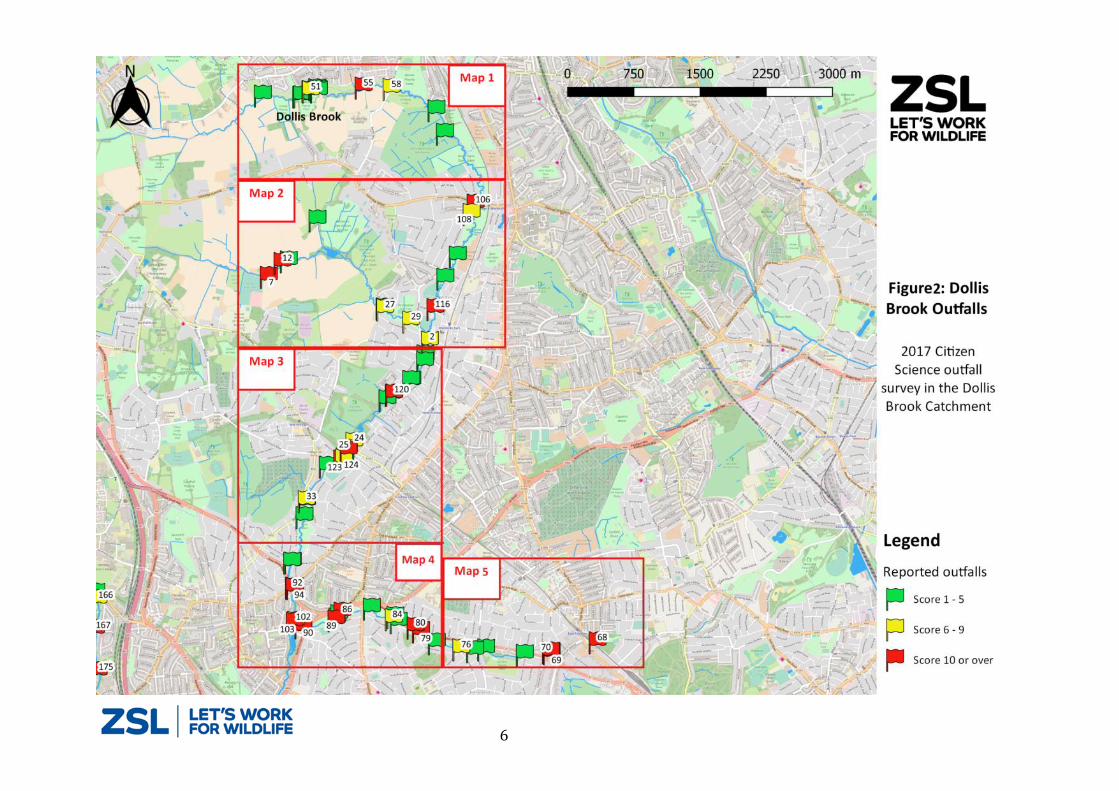
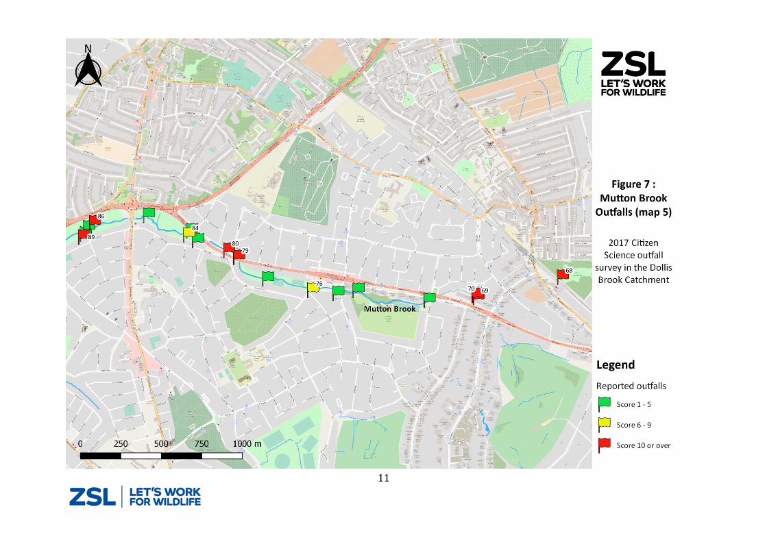
Results
The volunteers photographed, located and assessed a total of 178 outfalls. Of this total 90
showed some signs of pollution and scored ˃ 0 and of these 47 were significantly polluting
with a score ≥ 6. The locations of these outfalls are shown in Figures 2 to 11. The colour of
the flags shown in the maps reflects the impact score for each outfall. The details of the
outfalls with in impact score of ≥ 6 are given in Table 2. The numbers on the flags in Figures
2 to 11 references outfalls listed in Table 2.
Outfalls 134 and 163 (Table 2) were reported from the river during the survey. The
references for outfall 134 were EA- 151 2107 and Thames Water- 870331 956 705 and for
163, EA- 151 2210 and Thames Water 70331975701. On 02/05/2017, details of the 29
outfalls that scored ≥10 were reported via the EA’s Incident Hotline (reference number
1520015).
The full 2017 Dollis Brook and Silk Stream Outfall Safari dataset is available from ZSL.
Page 17
17
Table 2 – Details and photos of outfalls shown in figure 1 to 11- only outfalls with an impact score of greater ≥ 6 are included in the table Photo
ID Location Details NGR
Bank Side
Outfall Score
Photo
2 Upstream of the footbridge to Holden
Road, access via Westbury Road TQ2549692384 Left 8
7 Start of the footpath near the entrance
to Folly Farm/Burtonhole Lane TQ2365693069 Left 12
12 Approximately 200m downstream of
the entrance to Folly Farm TQ2380793230 Left 12
24 The allotments approximately 80m
upstream of Dollis Rd TQ2467091221 Left 8
25 Approximately 50m upstream of the
tube viaduct near Dollis Rd TQ2461091143 Left 8
27 Access via Michleham Down, in
Woodsize Park TQ2498292735 Right 8
29 Near the Woodside Park sports club access road also near Chanctonbury
way TQ2528092606 Right 8
33 At the Hendon Avenue Footbridge TQ2414790548 Right 8
51 100 m from Dollis Brook Walk, access
via Alan Drive TQ2408395173 Left 8
55 200 m from Meadow Close or access
from Barnet Lane (300 m along footpath)
TQ2467795232 Left 12
Page 18
12
58 Just downstream of Barnett Lane TQ2499395223 Right 8
68 Between Cherry Tree wood & the tube
line- access via Brompton Grove, Mutton Brook
TQ2747989037 Left 12
69 Rear of Belvedere Court, Lyttelton
Road, Mutton Brook TQ2696388900 Left 16
70 Rear of Belvedere Court, Lyttelton
Road, Mutton Brook TQ2695488912 Right 12
76 Northway Bridge, Mutton Brook TQ2593988918 Right 8
79 Just downstream of Fallodon Way Road
Bridge (A1) TQ2547789110 Right 12
80 Downstream of Brookland Rise Road
Bridge, Mutton Brook TQ2541589151 Right 12
84 Dollis Valley Green Walk, near the A1-
footpath access off Addison Way TQ2516689240 Right 8
86 Dollis Valley Green Walk, Rear of a 38 Hurstwood Road- footpath access off
Addison Way TQ2458389300 Left 12
89 Dollis Valley Green Walk, Rear of a 54 Hurstwood Road- footpath access off
Addison Way TQ2451789212 Left 12
90 Downstream of the North Circular
Road- access via Bridge Lane TQ2414489122 Right 12
92 Just downstream of Hendon Lane Weir- access via Riverside Gardens
TQ2402789569 Right 12
Page 19
13
94 10 m downstream of Hendon Lane Weir- access via Riverside Gardens
TQ2403289565 Left 12
102 Access via the footpath from
Southbourne Crescent TQ2406089183 Left 6
103
50 m upstream of the Dollis Brook and Mutton Brook confluence- access via
the footpath from Southbourne Crescent
TQ2404589175 Right 12
106 Opposite 64 Totteridge Lane on the
Dollis Brook TQ2597593944 Left 12
108 Behind approximately 25 Longland Drive- access via the Dollis Valley
Greenwalk TQ2593393836 Right 8
116 Upstream of Tillingham Way- near 18
Lorian Close, N12 7DZ TQ2555092752 Left 12
120
Access via Fursby Rd - at the downstream end of the First Rd
allotments- visible from the Dollis Valley Greenwalk
TQ2510891778 Left 12
123 Just upstream of Dollis Road Bridge TQ2453891018 Left 12
124 Underneath Abercorn Road Bridge TQ2455891030 Right 8
127 20 m upstream of Mill Hill East
Underground Line- access off the Dollis Road
TQ2460891128 Left 12
134 Rosscoff, close TQ2003191015 Right 20
Page 20
14
136 Rosscoff Close, Silk Stream - access is
only from within the channel via Edgware Hospital
TQ2006590975 Right 10
139 Barnfield Road car park - just upstream
of bridge-Edgware TQ2020690721 Right 12
140 50 m upstream of Watling Avenue TQ2026990714 Right 6
144 Silk Stream Park 10m upstream of
Montrose avenue TQ2064690412 Right 12
146 Montrose Playing Fields at the foot
bridge near Greenway Gardens entrance to the park
TQ2069790156 Right 12
160 Near Marlow Court - access via in-
channel only TQ2156689607 Right 8
161 At Colindeep Lane bridge TQ2173589467 Right 8
163 Colindeep Lane and Rushgrove Avenue-
outfall is set back with a 5m polluted channel flowing into the Silk Stream
TQ2175189472 Right 12
164 Rushgrove Avenue (near 188) - access
in-channel only TQ2175389459 Right 12
166 Colin Crescent, off Colindeep Lane TQ2181689377 Right 8
167 Under Crossway Bridge, NW9 6RA TQ2179689035 Right 12
Page 21
15
170 Downstream end of Scottwell Drive, Crossway - access is via in- channel
TQ2179688867 Right 12
171 Upstream end of Hyde Estate Road TQ2179588816 Right 8
175 Behind the large Sainsburys on the A5 TQ2183988564 Right 12
Discussion
Some outfalls pollute intermittently and may not have been detected as a problem during the
survey but this report represents an audit of how outfalls, within the surveyed areas of the
Brent catchment, were behaving during the survey.
In total there are 66km of river in the Brent Catchment, this Outfall Safari surveyed 37% of this
length and recorded 29 seriously polluting outfalls (score of ≥ 10). This is 16% of all outfalls
assessed. Thames Waters’, Surface Water Outfall Programme team are working to remediate
42 Brent catchment outfalls during the 2015 to 2020 investment period (AMP 6). These data
show there needs to be a scaling up of effort to properly stem the flow of pollution via outfalls
into Brent Catchment rivers. Not all the outfalls assessed in the Outfall Safari are Thames
Water’s assets but many are and the Brent Catchment Partnership (BCP) request a response
from Thames Water to the findings of this report. BCP has four priority themes for improving
the ecological value of the rivers within the catchment, Theme 1 being to reduce pollution. The
objectives in this theme are:
By 2021, water quality in the Brent catchment has improved and has a ‘moderate’ ability
to support wildlife
o A ‘moderate’ ability to support wildlife and means that:
o Phosphate concentrations are 0.25 mg/l or less
o Dissolved oxygen levels are 54% saturation or higher
o Levels of total ammonia are no higher than 1.1mg/l
Page 22
16
By 2027, it will have a ‘good’ ability to support wildlife
o A ‘Good’ ability to support wildlife means that:
o Phosphate concentration are 0.12 mg/l or less
o Dissolved oxygen levels are 60% saturation or higher
o Levels of total ammonia are no higher than 0.6mg/l
Removing polluting entering the river via outfalls will be a significant step towards achieving
these objectives.
This report outlines the findings of the third Outfall Safari conducted in Greater London. Outfall
Safaris of the River Pinn and Ravensbourne are planned for Autumn 2017 in partnership with
Thames 21. Once these are conducted, ZSL will work with members of the Catchment
Partnerships in London to properly analyse Outfall Safari data and make recommendations
about the numbers of outfalls that need to be remediated annually to effectively tackle the
problem of pollution from outfalls degrading the ecological value of rivers in London.
References Dunk, M.J., McMath, S.M., Arikans, J., 2008. A new management approach for the remediation
of polluted surface water outfalls to improve river water quality. Water Environ. J. 22, 32–41.
Contact details Joe Pecorelli: Project Manager - Europe Conservation Programme
[email protected]