AN EMBEDDED WIRELESS SYSTEM FOR ESTIMATING THE EXPOSITION RISK IN FIRST EMERGENCY MANAGEMENT Cesare Alippi, Cristian Galperti Dipartimento di Elettronica e Informazione, Politecnico di Milano, P.za L.da Vinci 32, 20133 Milano, Italy {alippi,galperti}@elet.polimi.it Abstract: In this paper we propose the design of a wearable embedded system 1 for wirelessly delimiting an hazardous area during emergency, alerting the rescue operators when entering in it and measuring the consequent exposition time. (The dangerous area is previously identified, e.g., through suitable instrumenta- tion). The suggested approach, which is identically effective in indoor and outdoor environments, significantly extends existing solutions by not requiring any absolute position information for delimiting the hazardous area or fixed infrastructure as requested instead by GPS and UWB solutions. The proposed low-power system can be easily retrieved after use and ready to be deployed in a new environment. Index terms: Wireless sensor networks, Relative localisation systems, Civil Protection, Emergency Management. I. INTRODUCTION The recent floods across Europe, US and Asia, Tsunami, hazardous materials released following earthquakes, chemical accidents affecting populated areas have shown very complex emergency scenarios characterised by the presence of a time-evolving risk, which may affect the rescue team during intervention. The presence of a residual risk, i.e., a Damocles’s sward type of risk insisting on the emergency scene and triggered by the evolution of catastrophic phenomena, can further amplify the risk during operational emergency. The problem of estimating the closeness to hazardous areas and the time spent within it is of particular relevance in emergency and critical situations where the rescue team has to intervene not only in a safe area but also in areas characterised by a real risk (generally increasing while getting closer to the risk source, e.g., think of a chemical risk associated with the presence 1 Patent # A000983 pending. INTERNATIONAL JOURNAL ON SMART SENSING AND INTELLIGENT SYSTEMS, VOL. 1, NO. 3, SPETEMBER 2008 592
Transcript
AN EMBEDDED WIRELESS SYSTEM FOR ESTIMATING THE
EXPOSITION RISK IN FIRST EMERGENCY MANAGEMENT
Cesare Alippi, Cristian Galperti
Dipartimento di Elettronica e Informazione, Politecnico di Milano,
P.za L.da Vinci 32, 20133 Milano, Italy
{alippi,galperti}@elet.polimi.it
Abstract: In this paper we propose the design of a wearable embedded system1 for wirelessly delimiting
an hazardous area during emergency, alerting the rescue operators when entering in it and measuring the
consequent exposition time. (The dangerous area is previously identified, e.g., through suitable instrumenta-
tion). The suggested approach, which is identically effective in indoor and outdoor environments, significantly
extends existing solutions by not requiring any absolute position information for delimiting the hazardous
area or fixed infrastructure as requested instead by GPS and UWB solutions. The proposed low-power system
can be easily retrieved after use and ready to be deployed in a new environment.
The recent floods across Europe, US and Asia, Tsunami, hazardous materials released
following earthquakes, chemical accidents affecting populated areas have shown very complex
emergency scenarios characterised by the presence of a time-evolving risk, which may affect
the rescue team during intervention. The presence of a residual risk, i.e., a Damocles’s sward
type of risk insisting on the emergency scene and triggered by the evolution of catastrophic
phenomena, can further amplify the risk during operational emergency. The problem of
estimating the closeness to hazardous areas and the time spent within it is of particular
relevance in emergency and critical situations where the rescue team has to intervene not
only in a safe area but also in areas characterised by a real risk (generally increasing while
getting closer to the risk source, e.g., think of a chemical risk associated with the presence
1Patent # A000983 pending.
INTERNATIONAL JOURNAL ON SMART SENSING AND INTELLIGENT SYSTEMS, VOL. 1, NO. 3, SPETEMBER 2008
592
of toxic or nuclear substances). As such, it is not only important to define a safety belt but,
once the safety belt is violated, alerting the personnel and measuring the history and the time
duration spent within such areas to assess, afterward, the exposition risk.
Traditional solutions for delimiting emergency areas generally rely on emergency ribbons.
This solution badly scales with the area to be covered: ribbons are not robust and hardly
effective in situations where the size of the critical area changes over time; moreover, it is
different to evaluate the exposition risk through an automatic mechanism. Reasonable auto-
matic non-invasive solutions for delimiting a safety belt would require a fixed infrastructure to
estimate the absolute position of a moving entity (personnel) in indoor situations or satellite-
based technologies in outdoor cases. In particular, the literature suggests the use of Global
Positioning Systems (also terrestrial, e.g., through UWB [1]), position estimation by means
of radio frequency mechanisms [2] [3] or tessellation of the monitored area through passive
RFID devices (which contain their spatial coordinates in the tag) [4] [5] [6]. Distance is
then evaluated as the difference between the operator and a critical point positions. All these
solutions are costly and badly scale with the area to be covered in indoor applications, but
are generally effective in outdoor environments where GPS is the most suitable technological
solution [7] (provided enough satellite visibility is given). Furthermore, we should observe
that setting up a fixed localisation infrastructure in a dangerous area can be time consuming,
difficult to be implemented and not risk-free.
The approach suggested in this paper solves problems posed by the existing systems in
areas where a GPS solution cannot be applied (e.g., in indoor situations or whenever the
GPS signal is either weak or missing). In particular, by relying only on small and portable
wireless embedded devices, it neither requires knowledge of absolute information about the
environment nor a fixed infrastructure to be deployed in the field.
Here, delimiting a hazardous area can be intended as follows:
1) define the perimeter of the hazardous area;
2) delimit the whole hazard area;
3) introduce different risk levels and, consequently, different risk zones within the hazard
area.
Cesare Alippi, Cristian Galperti, An Embedded Wireless System For Estimating The Exposition Risk In First Emergency Management
593
Fig. 1: A possible application scenario
In the first case we aim at providing an alerting mechanism to the operator when leaving
the safety belt area and entering the risk one. In the second case we extend the first point by
monitoring the presence of the personnel in the whole hazardous area and not solely around
its perimeter; once there, we compute the exposition risk in terms of time spent by a member
of the emergency personnel within it (e.g., to assess the chemical exposition risk).
Surely, we can identify several security belts around the risk area (third case), each of
which possibly characterised by a different risk level; for each belt we evaluate the spatial
and temporal presence of a generic entity within the belt during emergency and, if required,
sensorial information acquired by the device.
Delimitation of a critical area can be accomplished by “tiling” it with a set of spherical
neighbourhoods (see figure 1) with neighbours radii that can be automatically adapted accord-
ing to the local requirements, both to reduce the number of neighbours and provide different
spatial resolutions (e.g., adaptation could rely on sensors such as electronic gas sensors or
labs on chip). In the following, without loss of generality, we focus on aspects addressing a
single belt area; extension to several belt areas is immediate.
In this paper we suggest a solution in which each neighbourhood is assigned to an em-
bedded wireless slave unit both defining an electromagnetic neighbourhood and carrying
out the information and communication processing. Slave units are deployed to cover the
area/perimeter to de delimited and, possibly, mount a sensorial board.
Each entity entering the emergency zone will be in possess of an embedded wireless master
unit; the unit, by interacting with slave ones will identify his/her presence in a critical area
INTERNATIONAL JOURNAL ON SMART SENSING AND INTELLIGENT SYSTEMS, VOL. 1, NO. 3, SPETEMBER 2008
594
Fig. 2: An application scenario with adaptive zones
and estimate the time exposition to the area as detailed in next sections. Master units can
mount sensors to address a specific risk.
Slave and master units define a mobile wireless sensor network with the slave deployed in
the emergency area (and generally fixed in position) and masters moving around being worn
by the personnel.
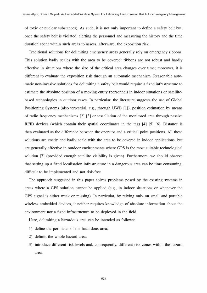
The problem of electromagnetically tiling an area and monitoring mobile master units
entering in contact with slave ones can be intuitively reduced to the interaction between a
single master and a given but, dynamic, number of slave units as presented in Figure 3.
Here, we assume that master and slave units are freely moving nodes in an unbound three-
dimensional space.
Every time the trajectory of the master unit enters a spherical neighbourhood of the slave
one (with a prefixed radius or threshold defining the concept of interaction) we say that the
two units interact and we have to measure the interaction time, i.e., the time during which
the two entities distance is below a threshold. These issues will be addressed in subsequent
sections.
The paper is structured as follows: section II formalises the proximity time estimation
problem and provides a high level overview of the suggested algorithm. Section III addresses
the case where only one master unit is present and several slave units interact with it without
interference. The extension to multi master-multi slave units, i.e., the case where personnel
is working close in an area, is addressed in section IV. Section V suggests an algorithm,
Cesare Alippi, Cristian Galperti, An Embedded Wireless System For Estimating The Exposition Risk In First Emergency Management
595
Fig. 3: Overview of the problem.
based on fuzzy logic, to group more than one wireless device to form a ’wireless safety belt’.
Finally, section VI provides some experimental results.
II. APPLICATION REQUIREMENTS AND OPERATIONAL ALGORITHMS FOR
MASTER AND SLAVE UNITS
The operational and critical nature of the emergency phase requires the system to be fully
automatic with master and slave units easily wearable and deployable.
In particular, the main task of a slave unit is to define the concept of interaction neighbour-
hood and, de facto, acts as an active radiofrequency identification device (RFId). Differently,
masters scan their neighbourhoods searching for slave units, negotiate the use of the shared
radio channel and control the radiofrequency RF- power for radio transmission purposes.
More in detail, a master sends an interrogation radio signal at a given RF power (which
creates a spherical electromagnetic field around the master) to investigate its neighbourhood
searching for slave units. Once slave units are detected, they are properly tracked; when a
slave exists the neighbourhood, the master stores the history of contacts (event) in its non
volatile memory (information which can be subsequently downloaded for a subsequent post
processing phase).
The geometry of the RF neighbourhood strongly depends on the antenna designed for
master and slave units. For simplify the problem, we consider ideal isotropic antennas for
which we have a straight relationship between the power density SA of an electromagnetic
wave at some point A in space, and the power density SB at some point B at distance r. In
INTERNATIONAL JOURNAL ON SMART SENSING AND INTELLIGENT SYSTEMS, VOL. 1, NO. 3, SPETEMBER 2008
596
Fig. 4: A high level representation of the master’s algorithm
particular, by referring to [8] we have that
SB
SA
∝ 1
rk(1)
where
k ≥ 2 (2)
This classic simple radio model (also called “free space model”) [9] [10], can be impaired
by reflection phenomena in indoor environments [11] and by antennas non idealities, which
reduce the isotropy of the electromagnetic field (as a consequence, a spherical neighbourhood
cannot be granted).
An Ultra Wide Band solution would provide more robust and accurate estimates of the
distance between two RF units but it requires high power consumption and system complexity;
moreover we didn’t find any embedded UWB transceiver able to measure distances integrable
in a small wearable equipment.
To deal with antenna non-idealities and electromagnetic wave reflections and refractions
(which affect the quality of the electromagnetic field by disrupting the spherical neighbour-
hood) a control of the master-slave interaction is needed; the high level structure of the
algorithm in execution on the master is given in figure 4.
More in detail, the node main time is based on a real time clock which, periodically
Cesare Alippi, Cristian Galperti, An Embedded Wireless System For Estimating The Exposition Risk In First Emergency Management
597
(e.g., each 1s), sends an interrupt activation signal enabling the interrogation procedure. As
a result, by sending a RF signal at a given RF power and waiting for a -possible- slave
response, the master looks for the presence of slaves in the neighbourhood. The “scan MAC
policy”) supersedes the negotiation of the radio channel between multiple masters whenever
more than one share the same spatial neighbourhood (we could not identify in the literature
for such unconnected ad-hoc network, a MAC layer fully satisfying our requests in terms of
time coherence and energy saving). The “MicroNet” module performs the radio interrogation
with our ad-hoc CSMA/CA -TDMA hybrid protocol. The outcome of this phase is a list of
slaves present within the interaction neighbourhood.
Then, an inference system based on fuzzy logic evaluates whether the master units belong
to one or more dangerous area or not and, in case of a positive answer, it generates an alarm
message for the person wearing the master unit.
Afterwards, the module “Events manager update” updates the information of the slaves
present in the list: when a master moves outside the neighbourhood the interaction with the
specific slave terminates and the information associated with the contact need to be stored in
the non volatile memory of the master unit for later use.
On the other hand, the task to be carried out by slave units is simpler: when slaves receive
an interrogation message they respond with a presence confirmation reply message. Reply
messages’ broadcast time and power are set according to master’s directives transmitted in
the interrogation message. Finally, battery status is included in the slaves’ messages allowing
the querying master to store energy status of the responding tags in his event logs. This
information could be important to subsequent off line data analysis.
III. THE SINGLE MASTER CASE
The single master case is the simplest operative situation where a single person wears a
master and several slave units interact with it. The case is characterized by a sparse connectiviy
network presents a sparse connectivity (i.e. the personnel moves far apart each other). In this
simple case the master does not need to negotiate the radio channel and the MAC block of
fig.4 is not activated.
INTERNATIONAL JOURNAL ON SMART SENSING AND INTELLIGENT SYSTEMS, VOL. 1, NO. 3, SPETEMBER 2008
598
Fig. 5: The interrogation message frame. The filled part is the transmitting one whereas theother is the receiving one.
A. The interrogation protocol (“MicroNet” interrogation)
The goal of the interrogation phase is to provide the list of slaves present in a specific
instant of time in the master’s spatial neighborhood. Since master units are highly mobile
(and hence the local topology of the master is subject to significant variations) some care
must be taken to control the radio communication. In particular, during transmission we have
to address the hidden radio problem where two or more units require transmittal information
to a common node but cannot communicate between them. A Carrier Sense Multiple Access
with Collision Avoidance (CSMA/CA) protocol was here considered which introduces an
acknowledgment mechanism to grant packet delivery [14] [15]. Unfortunately, CSMA/CA
requires repetition of transmission packets upon failure which does not only imply time
accuracy loss but unnecessary power consumption.
To solve the problem we opted for an ad-hoc Time Division Multiple Access (TDMA)
protocol, with the master unit controlling both protocol and slaves. Figure 5 shows the
implemented interrogation message’s frame as broadcast by masters.
First a preamble is broadcast by the master. This is used to synchronize receivers’ transceivers.
Then the interrogation message follows. At the end of the interrogation message the transceiver
is switched to the receiving mode and the master waits for slaves’ answers. Since master units
handle the TDMA protocol, they control time slots allocation and inform the slaves about the
allotted time for response. Whenever a slave receives the interrogation message it provides
its identification number in the assigned time slot. If the slave is new it has first to register
by transmitting a registration message in the registration time slot (registration phase in the
figure). Registration enables the master to register the slave by updating the slave list and
allocate a time slot to it (in the next neighbourhood scan the slave will be able to respond
Cesare Alippi, Cristian Galperti, An Embedded Wireless System For Estimating The Exposition Risk In First Emergency Management
599
once interrogated).
In the registration phase the communication stack is CSMA whereas, upon registration, a
slave responds in the allotted time hence using a TDMA communication stack. As such, the
hidden radio problem has been confined only to the registration phase which, for effectiveness
of the protocol, should be a rare event (false positive and negative events are managed by the
regularisation filter, as shown in the subsequent subsection).
Whenever the master identifies that a slave has moved outside its spatial neighborhood, the
associated time slot will be freed and information associated with the proximity time event
(e.g., start and time) is stored in the non volatile memory of the master unit.
B. The regularisation filter
The described interrogation mechanism suffers from the strong non ideal nature of the
electromagnetic field. As a consequence, we would generate many short contacts and unnec-
essary registration events which, in turn, will affect the MicroNet protocol efficacy, memory
usage and power consumption. Moreover this non-ideality heavily degrades the accuracy of
master and slaves distance extimate and the time measurement.
A simple regularisation filter was introduced for reconstructing the events by filtering
missing contacts due to communication problems. The regularisation algorithm is given in
equation (3).
Te,τ2 =
0 if new event
Te,τ1 + ∆tτ2,τ1 if ∆tτ2,τ1 ≤ Tf
(event confirmation)
Te,τ1 if ∆tτn,τ1 > Tf
(event termination)
(3)
where Te is the time duration of an active event (the time elapsed since a slave registration
and the associated event generation), τ1 and τ2 refer to two scanning events performed by
the master, with τ2 > τ1 (both time instants reporting a presence of the slave). τn refers to a
scanning event successive to τ1 for which no presence of slaves has been detected, ∆tτ2,τ1 is
INTERNATIONAL JOURNAL ON SMART SENSING AND INTELLIGENT SYSTEMS, VOL. 1, NO. 3, SPETEMBER 2008
600
the time elapsed between the radio scan performed at τ1 and the one performed at τ2, ∆tτn,τ1
is the time elapsed between the interrogation performed at τ1 and the one performed at τn
and, finally, Tf is a preset filter constant. The suggested filter is executed in correspondence
with each active event, in the interrogating phase. For all active events two conditions occur:
the time elapsed since the last contact is either below Tf (event confirmation condition in (3))
or above it (event termination condition in (3)). In the first case the time duration of the event
is updated by summing the time elapsed since the last contact (and the event is labelled as
being valid), in the second case the event is considered over and the slave is labelled as being
outside the master’s neighbourhood. When the slave exits the master’s neighbourhood the
associated event terminates and all contact information is stored in the non volatile memory.
C. The radio power control algorithm
In order to give the maximum amount of information to the inference subsystem, re-
duce power consumption and cross-interference, we implemented an algorithm adjusting the
communication power to its minimum value, yet granting communication between master
and slave. If we consider that the interrogation signal is common to all slaves whereas the
response signal belongs only to a specific one, it turns out that it is simpler to adjust the
slave’s answering signal than the master’s interrogation one. To accomplish this task, the
interrogation signal carries also the transmission power for each master registered in the
“MicroNet” protocol. As such, a registered slave always knows the power level to be used
for responding to a master, hence enabling the master to perform the power control algorithm
for each registered slave.
The power control algorithm is a tracking algorithm that aims at establishing the minimum
RF power requested to maintain each slave’s contact; the algorithm is given in (4).
xc,t+1 =
xc,init if new contact
xc,t if x = xmin and contact at t
xc,t if x = xmax and not contact at t
xc,t + 1 if x > xmin and not contact at t
xc,t − 1 if x > xmin and contact at t
(4)
Cesare Alippi, Cristian Galperti, An Embedded Wireless System For Estimating The Exposition Risk In First Emergency Management
601
Fig. 6: The function u and w.
The algorithm updates a status variable xc (one for each registered slave) at each neighbor’s
interrogation according to the presence of the slave in the previous interrogation. The actual
communication power Pc,t is a monotonically increasing function of xc,t. To gather a better
accuracy in distance measurement, especially in close proximity situations, we also opted
for changing the master receiver sensitivity so that the actual sensitivity σc,t is function of
the process variable xc. Thus, during a contact, the actual transmission power and receiver
sensitivity are updated as:
Pc,t = u[xc,t]
σc,t = w[xc,t](5)
The functions here adopted are depicted in figure 6. With this tracking technique, each
slave in contact with a master is characterized by a dynamically updated variable xc,t that
set radio communication physical parameters P and σ, and, in turn, modifies the maximum
distance of communication between master and slave, according to (1).
From (1) we see that value xc,t is related to the distance between master and slave and,
from figure 6, we have that the larger the distance between master and a slave the smaller
the value of its process variable.
IV. EXTENSION TO THE MULTI-MASTER CASE
The previous section has presented the core of the algorithm. Now, we have to extend it
to cover the multi-master case, i.e., the case where several masters are present in the same
area and entirely or partly interrogate the same neighbourhood.
INTERNATIONAL JOURNAL ON SMART SENSING AND INTELLIGENT SYSTEMS, VOL. 1, NO. 3, SPETEMBER 2008
602
A. The scan MAC policy.
Whenever two or more master interrogation regions overlap a channel sharing problem
arise. A MAC control algorithm must hence be implemented to arbitrate the radio channel
use. The suggested MAC policy can be summarised in two steps:
1) Before the beginning of the interrogation sequence, a handshake message is transmitted.
2) If a handshake message is received, every transmission is interdicted for a time equal
to the interrogation cycle time length (which is fixed).
This handshaking mechanism promotes only one master at time to perform the neighbour’s
interrogation while silencing all others. Since the master in possess of the channel is the one
broadcasting the handshake signal and the masters’ main node timers start the interrogation
sequence at the same fixed time for all masters, this algorithm always promotes the same
master. To enable all masters to perform the interrogation sequence, an auto-penalisation
mechanism has been introduced where the masters’ interrogation sequences are delayed with
respect to the main timer’s scan signals. The discrepancy between the timer scan signals
and the actual scan sequence does not affect the time measurement accuracy because the
penalisation delay is always smaller than the time interval between two neighbours’ scans.
The suggested equation ruling the penalisation delay Td is given in (6):
Td,t+1 =
Td,t if channel lost
Td,t + Tp if Td,t + Tp < Tscan
and channel won
0 if Td,t + Tp ≥ Tscan
and channel won
(6)
where
Tp ∼ U [0, Tscan] (7)
The penalisation delay is kept fixed if the master does not win the channel usage (i.e. if its
communication is inhibited by a received handshake message when a interrogation message
should be broadcast) while it is increased when the master wins the channel and performs
Cesare Alippi, Cristian Galperti, An Embedded Wireless System For Estimating The Exposition Risk In First Emergency Management
603
an interrogation. The delay is increased by a random variable of uniform distribution in
the [0, Tscan] interval, Tscan being the main node timer interval between two consecutive
interrogations. The delay cannot become larger than Tscan in order to maintain time correlation
between actual interrogation and events.
B. Radio power co-reduction algorithm
If the system is employed only for measuring proximity time (for example in the patient
care measurement example presented in section VI), the situation involving more than one
master in the same spatial region needs a deeper analysis. When the master interrogation areas
heavily overlap, the overall problem of measuring the proximity time becomes meaningless
since it is not possible to distinguish the master scan boundaries. To deal with this fact,
a radio power co-reduction algorithm has been included in the handshaking mechanism.
This algorithm reduces the communication power of the interrogation messages to increase
the boundary separation among masters. The algorithm activates whenever a master realizes
the presence of other masters in its neighbourhood. The co-reduction algorithm operates as
follows:
1) When a master realizes to be in a multi-master condition it generates a requested
maximum value for the communication power, which is broadcast in its handshake
message.
2) When a master receives a handshake message it enters a multi-master condition and,
consequently, lowers its power transmission according with the information present in
the handshake message.
3) The power reduces to its minimum value.
4) When a master does not receive a handshake message for a preset amount of time, it
disengages the multi-master condition and raises the transmitting power to a normal
value.
In other words, the algorithm decreases the communication power between master nodes
whenever two or more masters are co-present. Obviously, the power profiles of fig. 6 are
modified to respect the mutual maximum condition, i.e., the transmitting power pattern is
INTERNATIONAL JOURNAL ON SMART SENSING AND INTELLIGENT SYSTEMS, VOL. 1, NO. 3, SPETEMBER 2008
604
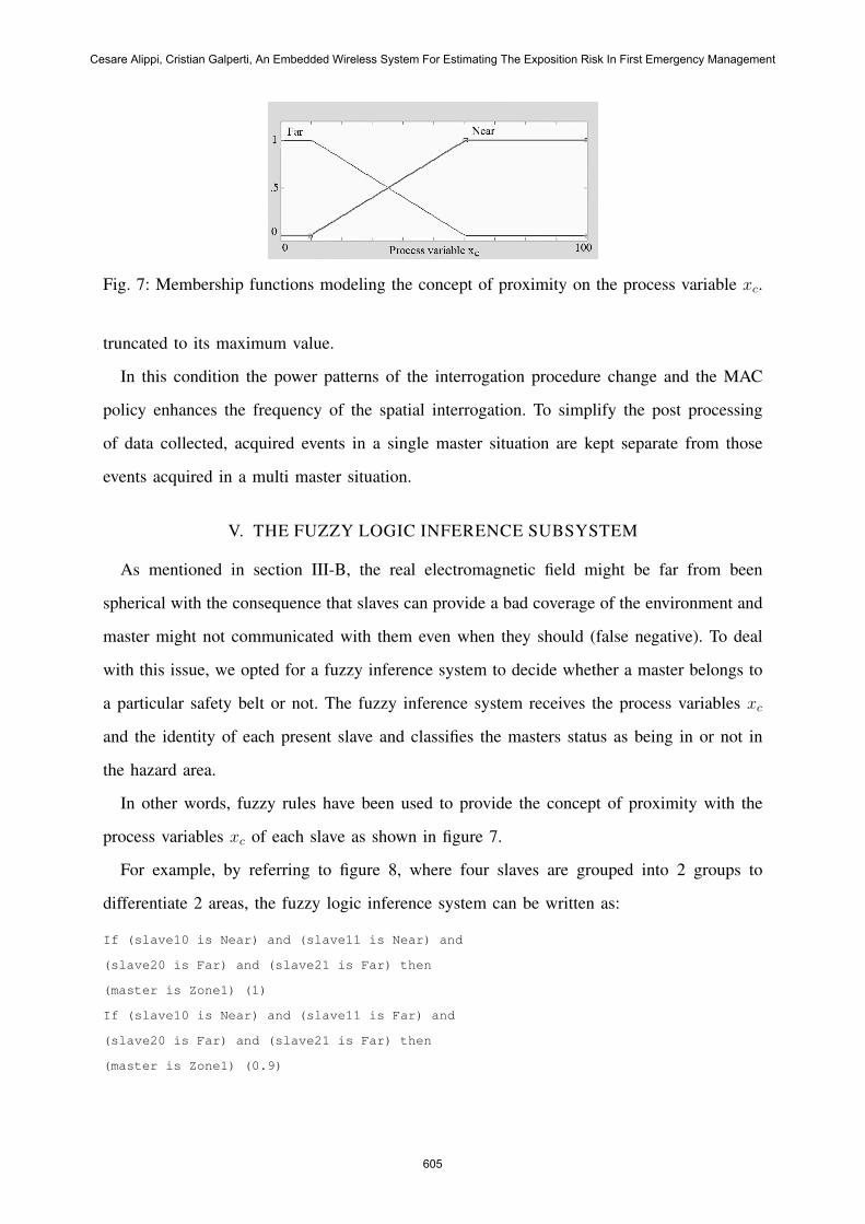
Fig. 7: Membership functions modeling the concept of proximity on the process variable xc.
truncated to its maximum value.
In this condition the power patterns of the interrogation procedure change and the MAC
policy enhances the frequency of the spatial interrogation. To simplify the post processing
of data collected, acquired events in a single master situation are kept separate from those
events acquired in a multi master situation.
V. THE FUZZY LOGIC INFERENCE SUBSYSTEM
As mentioned in section III-B, the real electromagnetic field might be far from been
spherical with the consequence that slaves can provide a bad coverage of the environment and
master might not communicated with them even when they should (false negative). To deal
with this issue, we opted for a fuzzy inference system to decide whether a master belongs to
a particular safety belt or not. The fuzzy inference system receives the process variables xc
and the identity of each present slave and classifies the masters status as being in or not in
the hazard area.
In other words, fuzzy rules have been used to provide the concept of proximity with the
process variables xc of each slave as shown in figure 7.
For example, by referring to figure 8, where four slaves are grouped into 2 groups to
differentiate 2 areas, the fuzzy logic inference system can be written as:
If (slave10 is Near) and (slave11 is Near) and
(slave20 is Far) and (slave21 is Far) then
(master is Zone1) (1)
If (slave10 is Near) and (slave11 is Far) and
(slave20 is Far) and (slave21 is Far) then
(master is Zone1) (0.9)
Cesare Alippi, Cristian Galperti, An Embedded Wireless System For Estimating The Exposition Risk In First Emergency Management
605
Fig. 8: A simple scenario with 2 groups of 2 slave units delimiting 2 areas.
...
If (slave10 is Far) and (slave11 is Far) and
(slave20 is Near) and (slave21 is Near) then
(master is Zone2) (1)
If (slave10 is Far) and (slave11 is Far) and
(slave20 is Near) and (slave21 is Far) then
(master is Zone2) (0.9)
...
If (slave10 is Far) and (slave11 is Far) and
(slave20 is Far) and (slave21 is Far) then
(master is Free) (0.2)
...
If (slave10 is Near) and (slave11 is Near) and
(slave20 is Near) and (slave21 is Near) then
(master is Dubt) (0.7)
If (slave10 is Near) and (slave11 is Far) and
(slave20 is Near) and (slave21 is Far) then
(master is Dubt) (0.6)
...
At the end of the fuzzy rule evaluation process, a fuzzy variable containing the status of the
master is computed while a singleton-based defuzzyfication rule provides the final status of
the master.
Figure 9 presents a possible defuzzification rule for the previous example. The actual
shape of slave membership functions as well as the rules weights have been experimentally
determined to grant the best accuracy in recognition.
INTERNATIONAL JOURNAL ON SMART SENSING AND INTELLIGENT SYSTEMS, VOL. 1, NO. 3, SPETEMBER 2008
606
Fig. 9: A possible singleton based defuzzification rule for the given example.
Fig. 10: A picture of the devices employed in experimental phases, left a slave unit, right amaster one.
VI. EXPERIMENTAL RESULTS
The designed master and slaves units are depicted in figure 10.
A. An indoor multi slaves localization experiment
The experiment refers to the indoor multi slave localization experiment depicted in figure 11
(a two zone indoor localization system deployed in a room). Six slaves are present, grouped
into two sets to generate two safety belts in the room (slaves A1 to A3 identify zone A
whereas slaves B1 to B3 identify zone B); the safety belts cover the whole environment.
The master performs the radio tracking algorithm and sends process variables xc,t to a base
station where the fuzzy logic inference subsystem is executed. By moving the master inside
the room we can assess the recognition ability of safety belt.
Cesare Alippi, Cristian Galperti, An Embedded Wireless System For Estimating The Exposition Risk In First Emergency Management
607
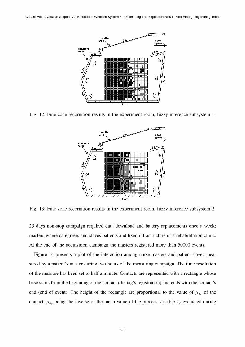
Fig. 11: Zone recornition results in the experiment room.
The figure shows that the system was actually able to differentiate the two zones within
the environment (characterized by the presence of strong EM reflections). Figure 12 is a
detailed version of 11. We note that the border between zone A and B is not symmetrical
with respect to the center of the room, probably due to electromagnetic reflection phenomena
in the room. The presence of the status “doubt” is evident in the lower part of the zone (gray
squares). As discussed in the article, zone boundaries are reconfigurable by adjusting nodes
RF power or fuzzy member functions. Here we adjusted the membership functions of zone
B to be more permissive to the “near” concept, basically translating the ramps of figure 7 to
lower values. Figure 13 displays the same experiment with these new membership functions.
Zones are more well balanced with a correct association of the “doubt” position in the middle.
The effect of this change, as well as the easiness of zone reconfiguration manifested by this
system, is demonstrated.
B. A patient care measurement application in hospitals
The experiment was selected for its highly expressivity, also in terms of complexity in-
teraction among people and fixed entities. Here we are assuming a contamination risk for
the rescue team and we wish to evaluate their complexity in terms of assistance needs; in
turn we could easily use the same model to estimate the time interaction among the rescue
personnel (master units) and contamined people (slave units) following a NaTech risk. The
INTERNATIONAL JOURNAL ON SMART SENSING AND INTELLIGENT SYSTEMS, VOL. 1, NO. 3, SPETEMBER 2008
608
Fig. 12: Fine zone recornition results in the experiment room, fuzzy inference subsystem 1.
Fig. 13: Fine zone recornition results in the experiment room, fuzzy inference subsystem 2.
25 days non-stop campaign required data download and battery replacements once a week;
masters where caregivers and slaves patients and fixed infrastructure of a rehabilitation clinic.
At the end of the acquisition campaign the masters registered more than 50000 events.
Figure 14 presents a plot of the interaction among nurse-masters and patient-slaves mea-
sured by a patient’s master during two hours of the measuring campaign. The time resolution
of the measure has been set to half a minute. Contacts are represented with a rectangle whose
base starts from the beginning of the contact (the tag’s registration) and ends with the contact’s
end (end of event). The height of the rectangle are proportional to the value of µac of the
contact, µac being the inverse of the mean value of the process variable xc evaluated during
Cesare Alippi, Cristian Galperti, An Embedded Wireless System For Estimating The Exposition Risk In First Emergency Management
609
Fig. 14: History of contacts of a patient from 10.00 am to 12.00 am. The abscissa representstime, the ordinate the value µac of the contacts. Different grey shades represent three differenttags.
the contact time length.
In the figure we can distinguish three types of contacts (according to what stated in III-C).
In particular, event A has a very low value of µac and is quite long, so we can safely assume
that it is a good contact with a small master to slave distance. Contact C has a high value of
µac and, as such, the slave has been quite far from the master during the event. Contact B is
somehow in a middle position between A and C. In this first experimental phase we assumed
all contacts to be good contacts, regardless of values provided by µac
Table I shows the final results of the experimentation. The 15 slaves have been divided into
categories: hygiene facility, drugs facility, table facility, nurses and OTA (auxiliary personnel).
TABLE I: Experiment final results: complexity estimate of 5 patients. Contacts’ time lengthis in minutes.