AN EVALUATION OF THE CADASTRAL SYSTEM IN KENYA AND A STRATEGY FOR ITS MODERNIZATION By Gordon Okumu Wayumba A thesis submitted in fulfillment for the award of the Degree of Doctor of Philosophy in the University of Nairobi, School of Engineering, Department of Geospatial and Space Technology AUGUST, 2013
Transcript
AN EVALUATION OF THE CADASTRAL SYSTEM IN KENYA
AND A STRATEGY FOR ITS MODERNIZATION
By
Gordon Okumu Wayumba
A thesis submitted in fulfillment for the award of the Degree of
Doctor of Philosophy in the University of Nairobi, School of
Engineering, Department of Geospatial and Space Technology
AUGUST, 2013
ii
DECLARATION
I hereby declare that this thesis is my original work and has not been presented in
any other university for examination or award of any other degree
…………………………………………
Gordon Okumu Wayumba
Reg. No. F80/81401/2009
Supervisors
This thesis has been submitted for examination with our approval as university supervisors.
…………………………………………
Professor Francis W.O.Aduol
…………………………………………
Professor Crispus M. Kiamba
iii
DEDICATION
I dedicate this thesis first to the Almighty God who has granted me the strength and the
intellectual capacity to accomplish the thesis, for it is written in Proverbs 1:7 that the fear of the
Lord is the beginning of knowledge but fools despise wisdom and discipline.
I also dedicate this thesis to my wife Alice Wayumba and our children, Elizabeth, Steven and
Mary, Robert and Sandra, David and Nelly, Patrick and Benjamin; and my first grandchild
Emmy Aquino.
iv
ACKNOWLEDGEMENT
I wish to express my sincere thanks to many people who contributed towards the completion of
this thesis. Foremost, my supervisors, Professor Francis Aduol and Professor Crispus Makau
Kiamba who patiently guided me through the process of proposal writing up to completion of the
thesis itself. I am particularly indebted to Dr. David Nyika and Dr Winnie Mwangi, for their
critical reading and corrections which greatly improved the quality of the thesis.
I also wish to appreciate the support of members of the Department of Geospatial and Space
Technology, Dr Sammy Musyoka, chairman of the Department, Dr Faith Karanja, and Dr David
Siriba for their kind contributions in different ways which made this thesis a success.
I am also grateful to Eric Nyadimo of Oakar Services and David Muthama of ESRI (East Africa)
for helping with writing of the scripts in Visual Basic and Dennis Milewa for assistance with
database design. I also thank Paul Musembi for his assistance in the final stages of the thesis.
I sincerely thank Dr Okoth Ayugi of the Department of Geospatial Sciences and Engineering,
Technical University of Kenya, for his contribution on Smiths Normalization procedures, design
of the database and critical reading of the thesis. I appreciate the support of Angela Achieng
Atieno for typing various parts of the thesis and George Ted Osewe for technical support all
along.
Lastly, I am most grateful to my family members who supported me in many ways. First to
Robert who was useful in several discussions concerning the thesis; Patrick who did a lot of
computer work for me and Benjamin who inspired me through discussions and challenges with
modern technologies. I am most grateful to my wife Alice Wayumba who endured several lonely
nights as I worked on the thesis to small hours of the morning.
v
TABLE OF CONTENTS
DECLARATION ....................................................................................................................................................... ii
DEDICATION .......................................................................................................................................................... iii
ACKNOWLEDGEMENT ....................................................................................................................................... iv
TABLE OF CONTENTS ......................................................................................................................................... v
List of Figures ........................................................................................................................................................ ix
List of Tables ........................................................................................................................................................... x
List of Appendices ............................................................................................................................................... xii
List of Abbreviations and Acronyms ......................................................................................................... xiii
CHAPTER ONE ........................................................................................................................................................ 1
1.1 General Background ................................................................................................................................... 1
1.2 Statement of the Problem ........................................................................................................................... 5
1.3 Research Objectives ...................................................................................................................................... 7
1.4 Justification and Relevance ........................................................................................................................ 8
1.5 Scope and Limitations of the Thesis .................................................................................................. 11
1.6 Significance of the Study ........................................................................................................................ 11
1.7 Definition of Key Terms ......................................................................................................................... 12
1.7 Organization of the Thesis ...................................................................................................................... 14
CHAPTER TWO ................................................................................................................................................... 15
THE CADASTRAL SYSTEM IN KENYA ........................................................................................................ 15
2.1 The Structure of the System ................................................................................................................... 15
vi
2.2 Cadastral Surveying and Mapping System ........................................................................................ 15
2.3 The Cadastral Boundary Systems in Kenya ...................................................................................... 16 2.3.1 The Fixed Boundary .......................................................................................................................... 16 2.3.2 The General Boundary...................................................................................................................... 17 2.3.3 The Fixed General Boundary ......................................................................................................... 20
2.4 The Land Tenure Systems in Kenya .................................................................................................... 20 2.4.1 The Public Land Tenure ................................................................................................................... 21 2.4.2 The Private Land Tenure ................................................................................................................. 21 2.4.3 The Customary Land Tenure ......................................................................................................... 22 2.4.4 The Informal Land Tenure .............................................................................................................. 23 2.4.5 The Ten-Mile Coastal Strip ............................................................................................................. 23 2.4.6 A Critique of the Land Tenure System in Kenya ..................................................................... 24
2.5 Land Registration Systems in Kenya ................................................................................................... 25 2.5.1 Registration under RDA ................................................................................................................... 26 2.5.2 Registration under LTA .................................................................................................................... 26 2.5.3 Registration under GLA.................................................................................................................... 27 2.5.4 Registration under RTA ................................................................................................................... 28 2.5.5 Registration under RLA ................................................................................................................... 29 2.5.6 Land Registration Act No.3 of 2012 .......................................................................................... 29 2.5.7 A Critique of the Registration Systems ...................................................................................... 30
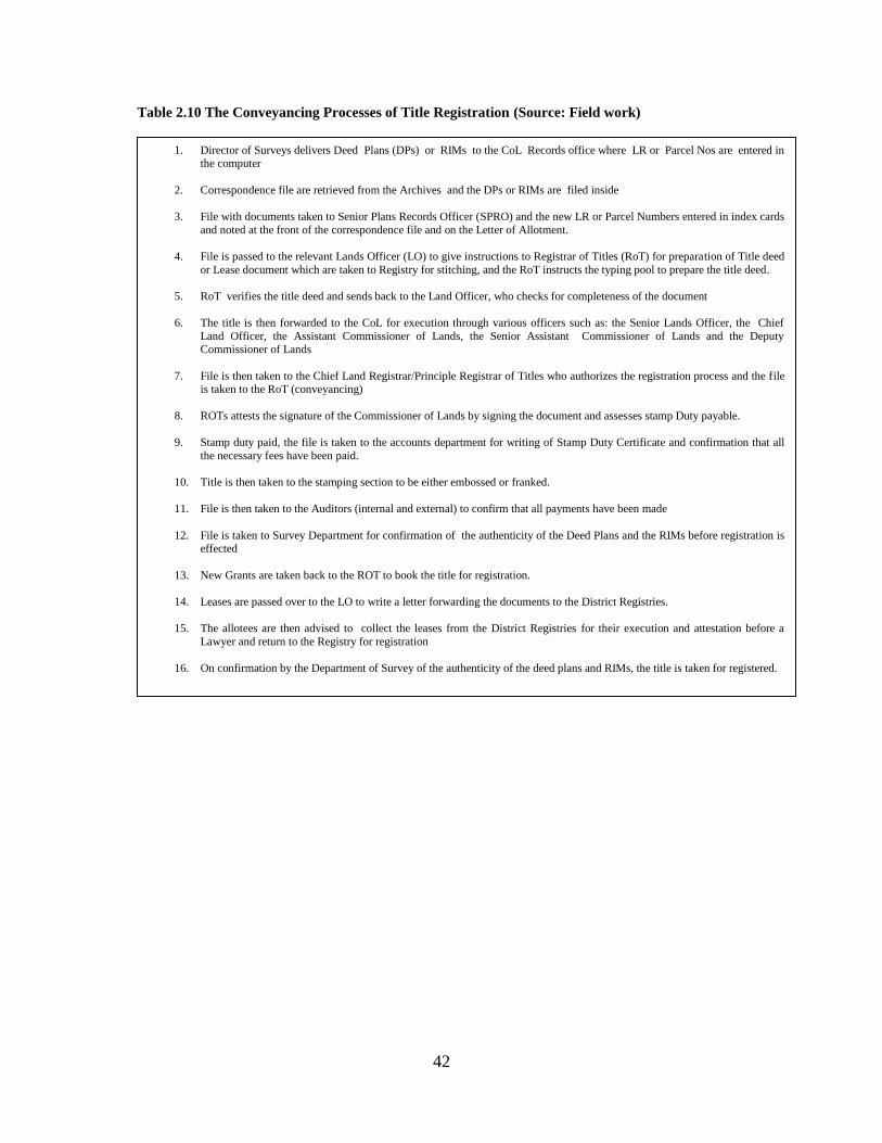
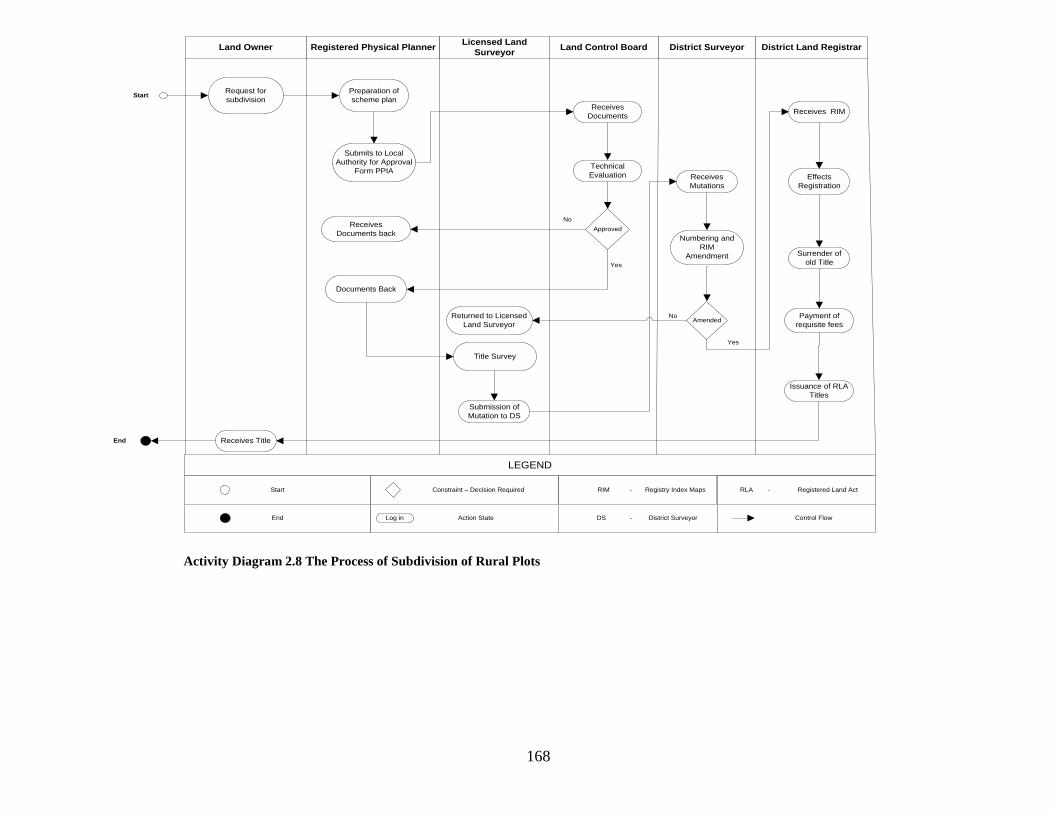
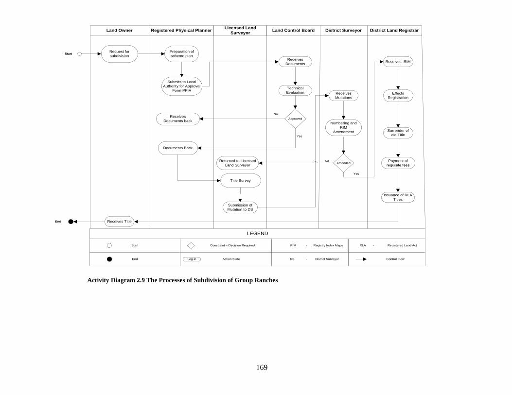
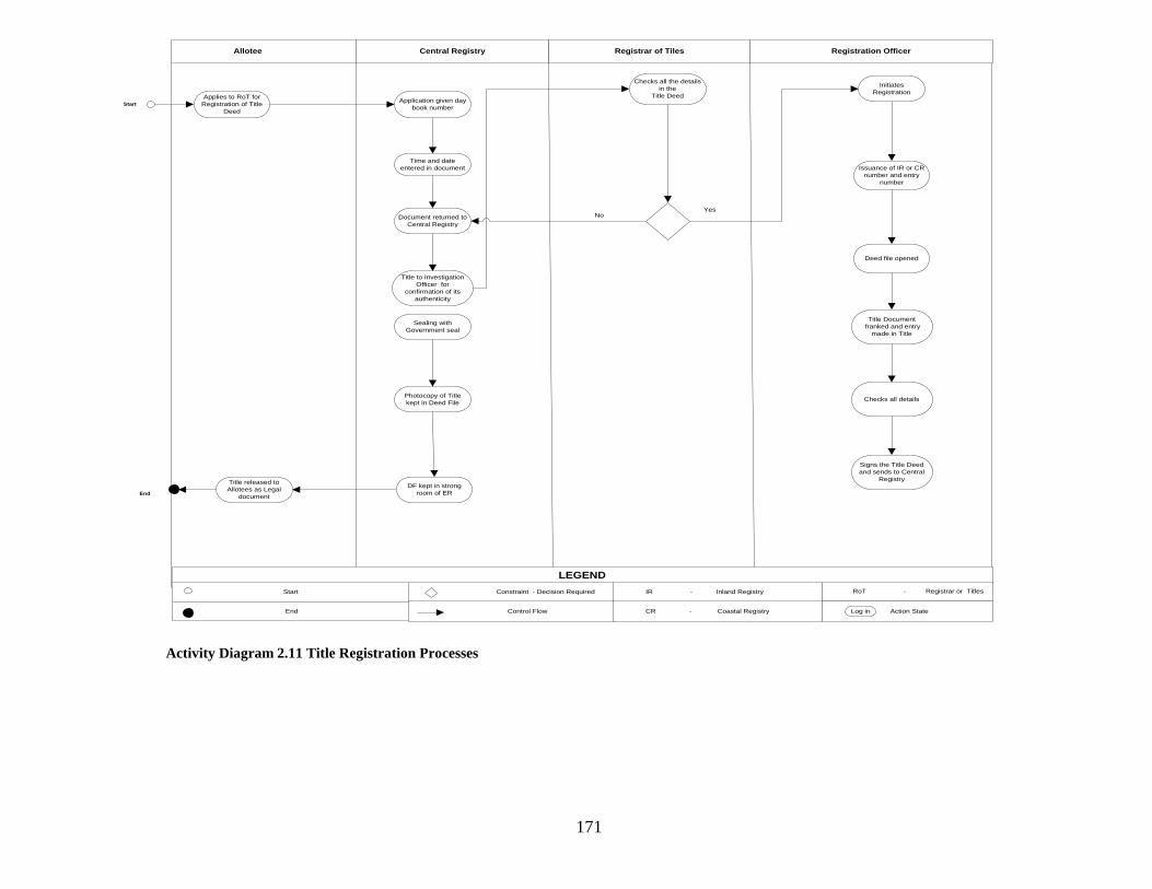
2.6 The Cadastral Processes in Kenya ........................................................................................................ 30 2.6.1 General Introduction ......................................................................................................................... 30 2.6.2 Physical Development Plans .......................................................................................................... 30 2.6. 3 The Physical Planning Act .............................................................................................................. 31 2.6.4 Allocation of New Grants ................................................................................................................. 31 2.6.5 Cadastral Surveying Processes ..................................................................................................... 32 2.6.6 Land Adjudication Processes ......................................................................................................... 35 2.6.7 Land Subdivision Processes ........................................................................................................... 36 2.6.8 Title Registration Processes ........................................................................................................... 37 2.6. General Comments ............................................................................................................................... 43
CHAPTER THREE ............................................................................................................................................... 44
STRATEGIES FOR A MODERN CADASTRAL SYSTEM........................................................................... 44
3.1 General Introduction ................................................................................................................................. 44
3.2 The Achievements ...................................................................................................................................... 44 3.2.1 Land Adjudication Programmes ................................................................................................... 44 3.2.2 Settlement Schemes and Cooperative Farms .......................................................................... 45 3.2.3 Information Communication Technology (ICT) Unit ........................................................... 45 3.2.4 National Land Information Management System (NLIMS) ................................................ 46
vii
3.2.5 Computerization in the Department of Survey ....................................................................... 46 3.2.6 Kenya National Spatial Data Infrastructure (KNSDI) ........................................................... 47 3.2.7 Development of a National Land Policy ..................................................................................... 47 3.2.8 Development of Unique Parcel Identifier ................................................................................. 48 3.2.9 Mapping of the Exclusive Economic Zone ................................................................................ 48 3.2.10 Development of a Modern Geodetic Reference Frame ..................................................... 49
3.3 Challenges Facing the Cadastral System in Kenya ......................................................................... 50 3.3.1 The structure of the system............................................................................................................ 50 3.3.2 Land Tenure System .......................................................................................................................... 51 3.3.3 Digital Land Information ................................................................................................................. 51 3.3.4 The Cadastral Data Models ............................................................................................................. 52 3.3.5 Land Parcel Boundaries ................................................................................................................... 52 3.3.6 Land Registration Systems ............................................................................................................. 53 3.3.7 Slow Adoption of Modern Technology ....................................................................................... 53 3.3.8 Duplication of Land Information .................................................................................................. 54 3.3.9 Low Cadastral Coverage .................................................................................................................. 54 3.3.10 Lack of 3D Cadastre ........................................................................................................................ 55
3.4 Evaluation of the Cadastral system ..................................................................................................... 55
3.5 Cadastre 2014 Model ................................................................................................................................ 55 3.5.1 Cadastre 2034 ...................................................................................................................................... 59 3.5.2 A Critique of Cadastre 2014 and Cadastre 2034 .................................................................. 60 3.5.3 A Summary ............................................................................................................................................ 60
CHAPTER FOUR .................................................................................................................................................. 62
REASEARCH DESIGN AND METHODOLOGY ........................................................................................... 62
4.1 Evaluation of the Cadastral System ..................................................................................................... 62
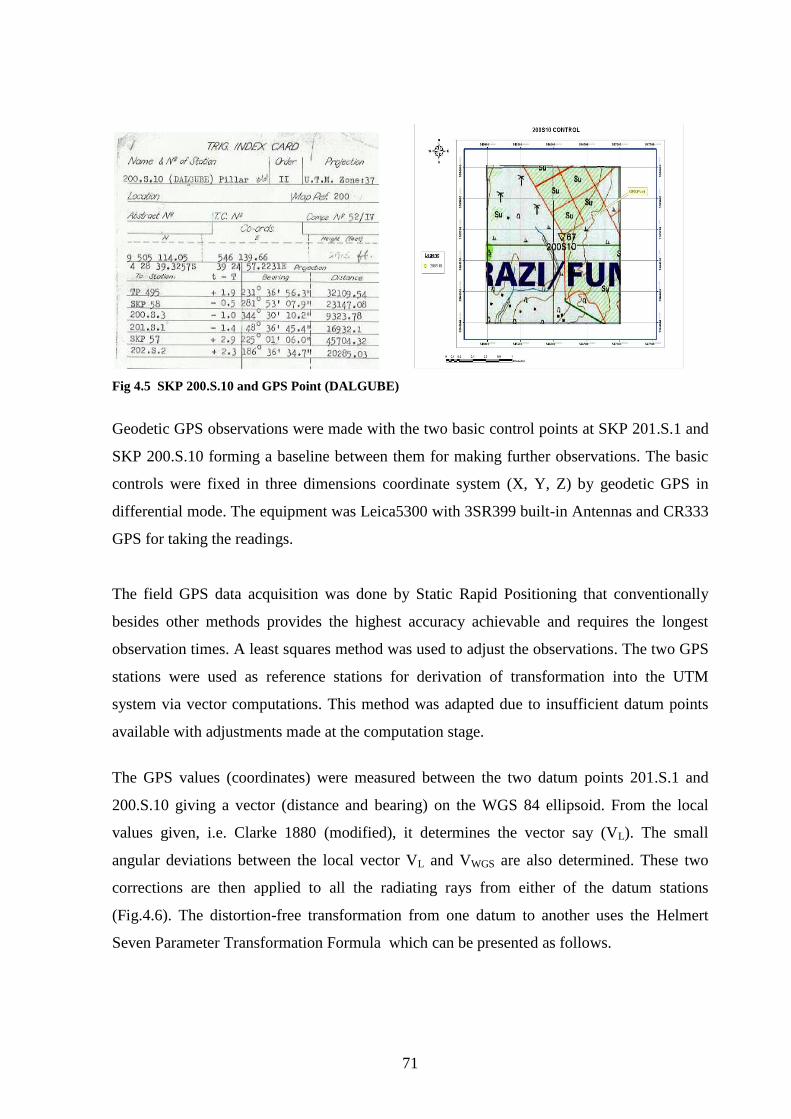
4.2 Testing of Geospatial Technologies ..................................................................................................... 63 4.2.1 The GPS Technology .......................................................................................................................... 64 4.2.2 Point Positioning ................................................................................................................................ 64 4.2.3 Relative Positioning ........................................................................................................................... 65 4.2.4 GPS-RTK Positioning ......................................................................................................................... 67 4.2.5 Field Measurements .......................................................................................................................... 68 4.2.6 Measurements of General Boundaries. ...................................................................................... 73
4.3 Remote Sensing Technology .................................................................................................................. 74 4.3.1 Introduction ......................................................................................................................................... 74 4.3.2 The study Area .................................................................................................................................... 75
4.4 GIS and Cadastral Modelling in Kenya ................................................................................................ 77
viii
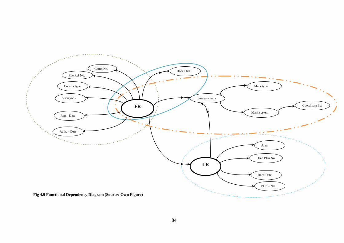
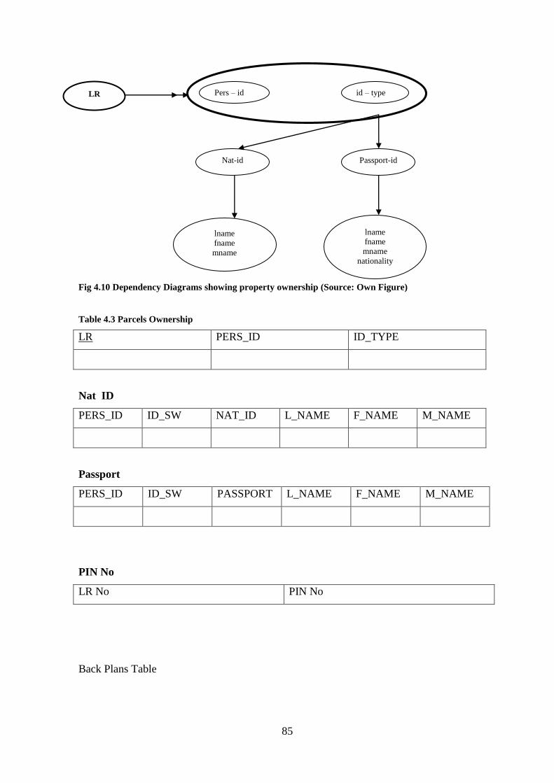
4.4.1 Introduction ......................................................................................................................................... 77 4.4.2 Design of the Modern Cadastral Database Model .................................................................. 78 4.4.3 Conceptual Data Modeling .............................................................................................................. 79 4.4.4 Logical Modeling ................................................................................................................................. 81 4.4.5 Physical Level Modelling ................................................................................................................. 88 4.4.6 The study Site ...................................................................................................................................... 88 4.4.7 Transformation of Coordinates .................................................................................................... 88
CHAPTER FIVE .................................................................................................................................................... 91
DATA FINDINGS AND ANALYSIS ................................................................................................................. 91
5.1 Results of the Evaluation Processes .................................................................................................... 91 5.1.1 The Strengths of the System .......................................................................................................... 94 5.1.2 The Weaknesses of the System ..................................................................................................... 96
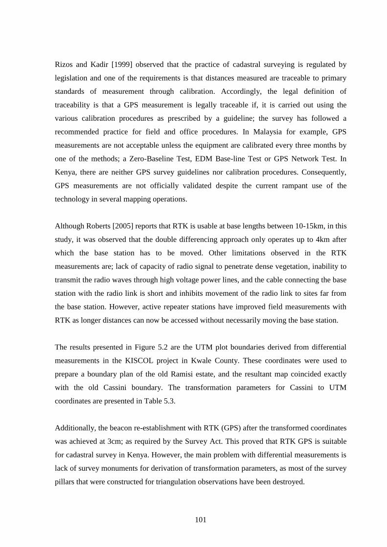
5.2 Results of Geospatial technologies ..................................................................................................... 100 5.2.1 The Global Positioning ................................................................................................................... 100 5.2.2 GPS and Fixation of General Boundaries ................................................................................. 102
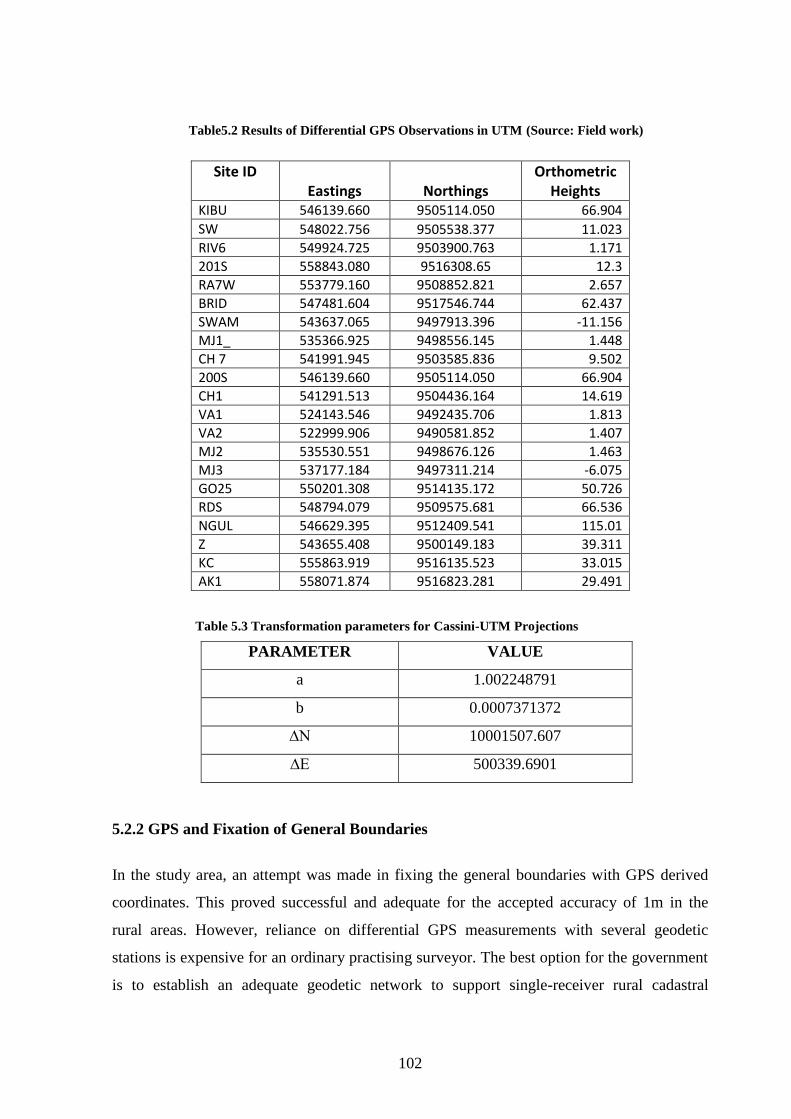
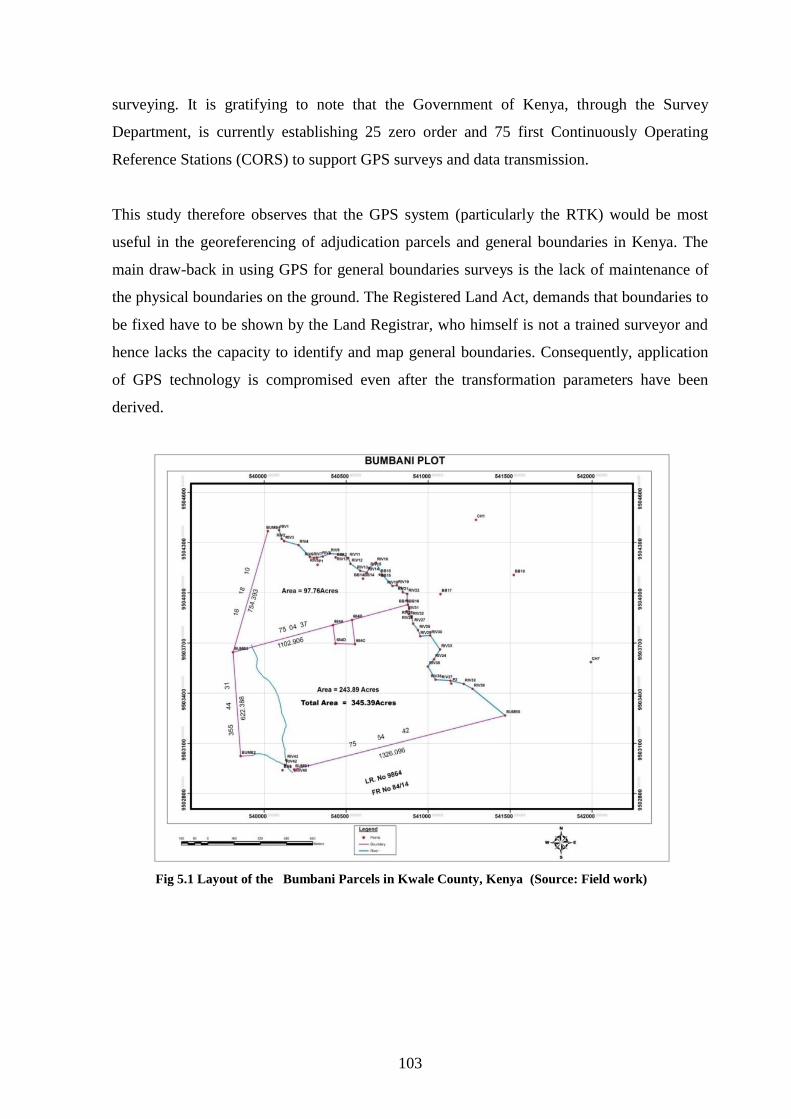
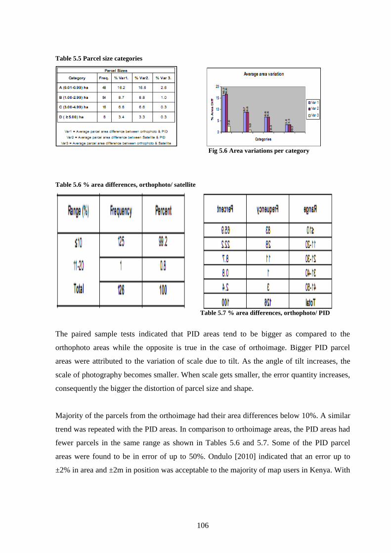
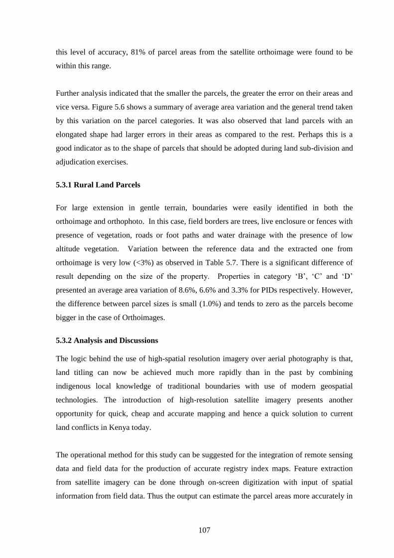
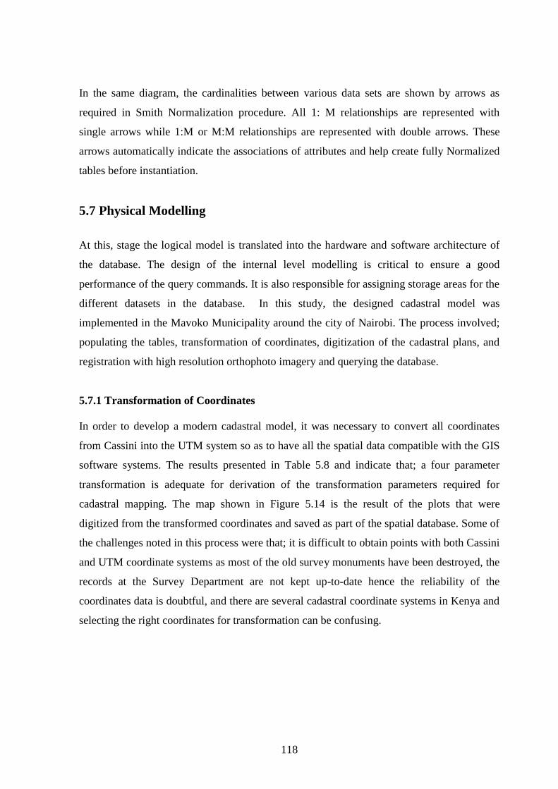
5.3 Satellite Imagery Mapping .................................................................................................................... 104 5.3.1 Rural Land Parcels ........................................................................................................................... 107 5.3.2 Analysis and Discussions ............................................................................................................... 107
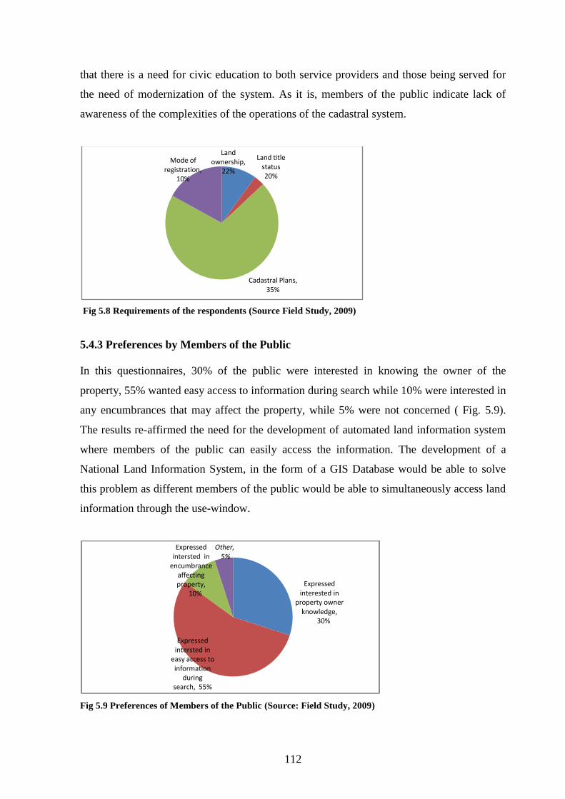
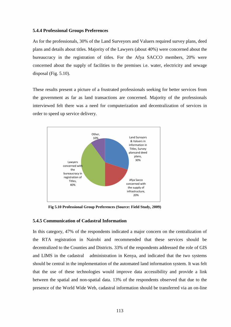
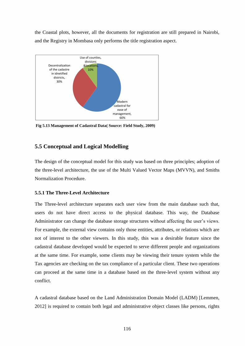
5.4 Development of a Modern Cadastral Database ............................................................................. 109 5.4.1 Distribution of Respondents ........................................................................................................ 109 5.4.2. Requirements of the Respondents ........................................................................................... 111 5.4.3 Preferences by Members of the Public ..................................................................................... 112 5.4.4 Professional Groups Preferences ............................................................................................... 113 5.4.5 Communication of Cadastral Information .............................................................................. 113 5.4.6 Data to be included in the Database .......................................................................................... 114 5.4.7 Modern Management of the Cadastre ...................................................................................... 115
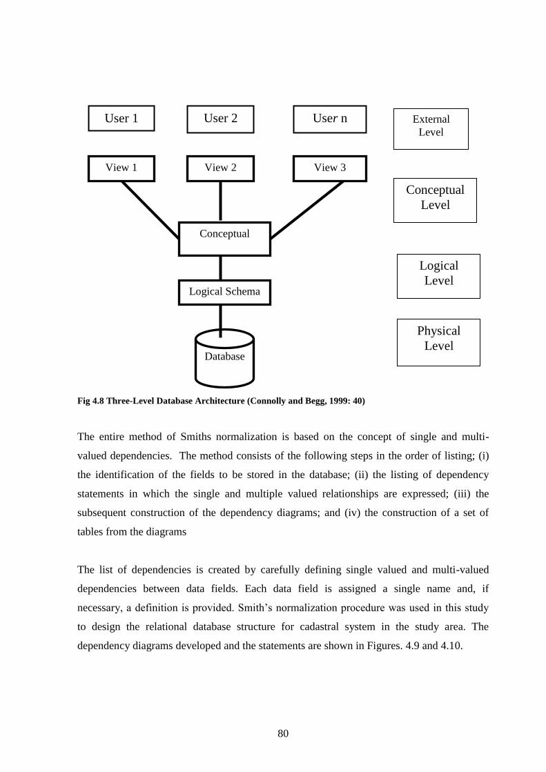
5.5 Conceptual and Logical Modelling ..................................................................................................... 116 5.5.1 The Three-Level Architecture ..................................................................................................... 116 5.5.2 The Multi Valued Vector Map ...................................................................................................... 117 5.5.3 Smiths Normalization Procedure ............................................................................................... 117
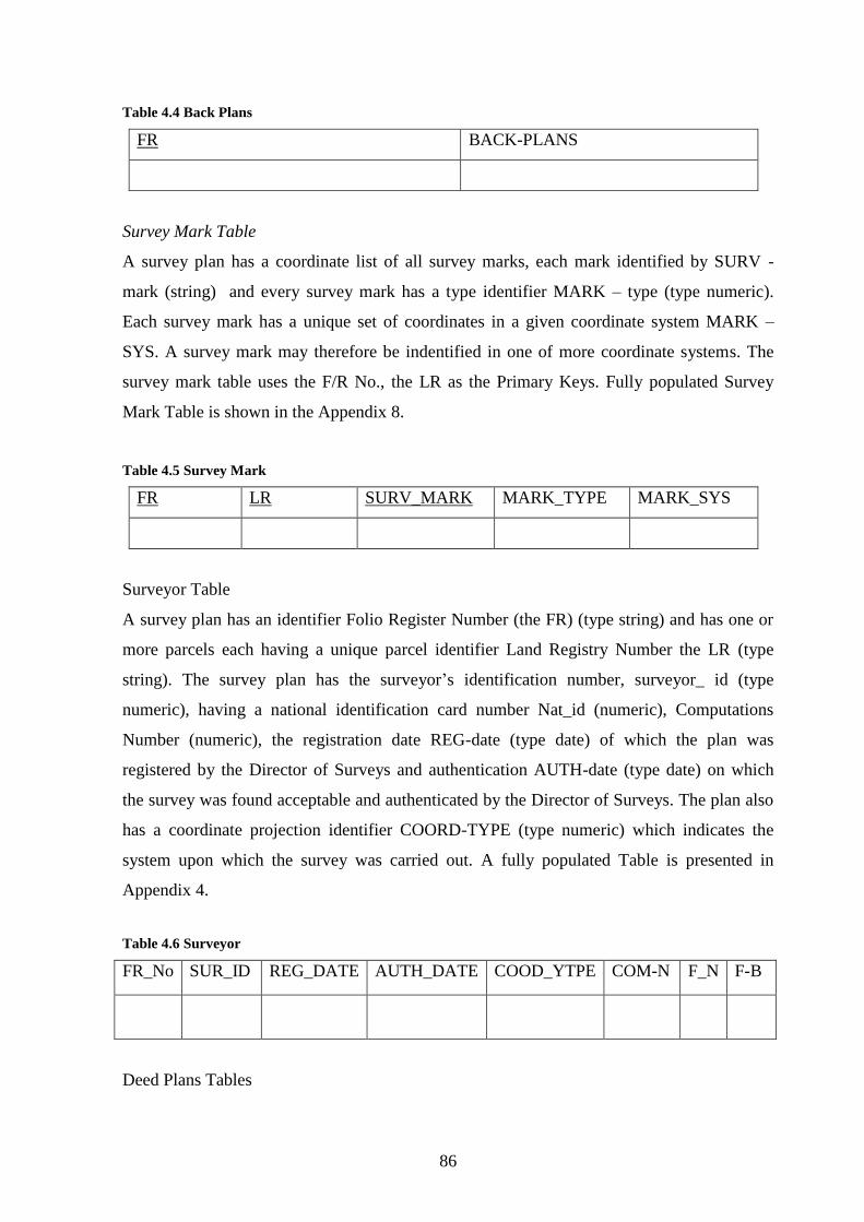
5.7 Physical Modelling ................................................................................................................................... 118 5.7.1 Transformation of Coordinates .................................................................................................. 118 5.7.2 Acquisition of High Spatial Resolution Imagery ................................................................... 119 5.7.3 Composition of Normalized Tables ........................................................................................... 121 5.7.4 The Query Operations .................................................................................................................... 121 5.7.5 The Cadastral Database Model .................................................................................................... 129
CHAPTER SIX ..................................................................................................................................................... 131
Appendix 11 List of Cassini Coordinates of the Nucleus Estate (1950) Arc Datum ............... 158
Appedix 12 List of UTM Coordinates of the Nucleus Estate (1960 Arc Datum) ...................... 159
Appendix 13 List of UTM Coordinates of the Bumbani plot (1960 Arc Datum) ...................... 160
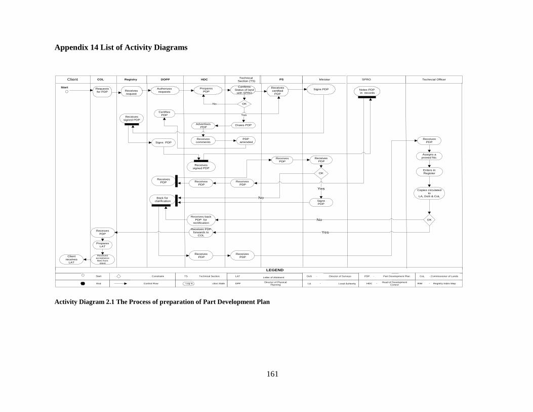
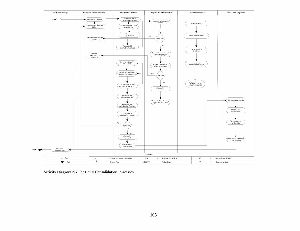
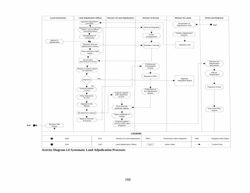
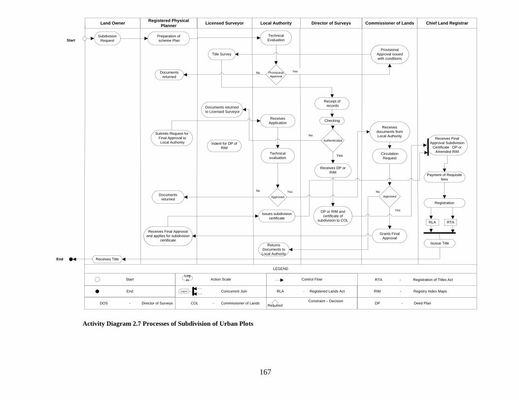
Appendix 14 List of Activity Diagrams .................................................................................................... 161
List of Abbreviations and Acronyms
UN - United Nations
FIG - International Federation of Surveyors
UNCHS United Nations Centre for Human Settlement (Habitat)
USA - United States of America
CFD - Swedish Central Board of Real Estate Data
GPS - Global Positioning System
GDP - Gross Domestic Product
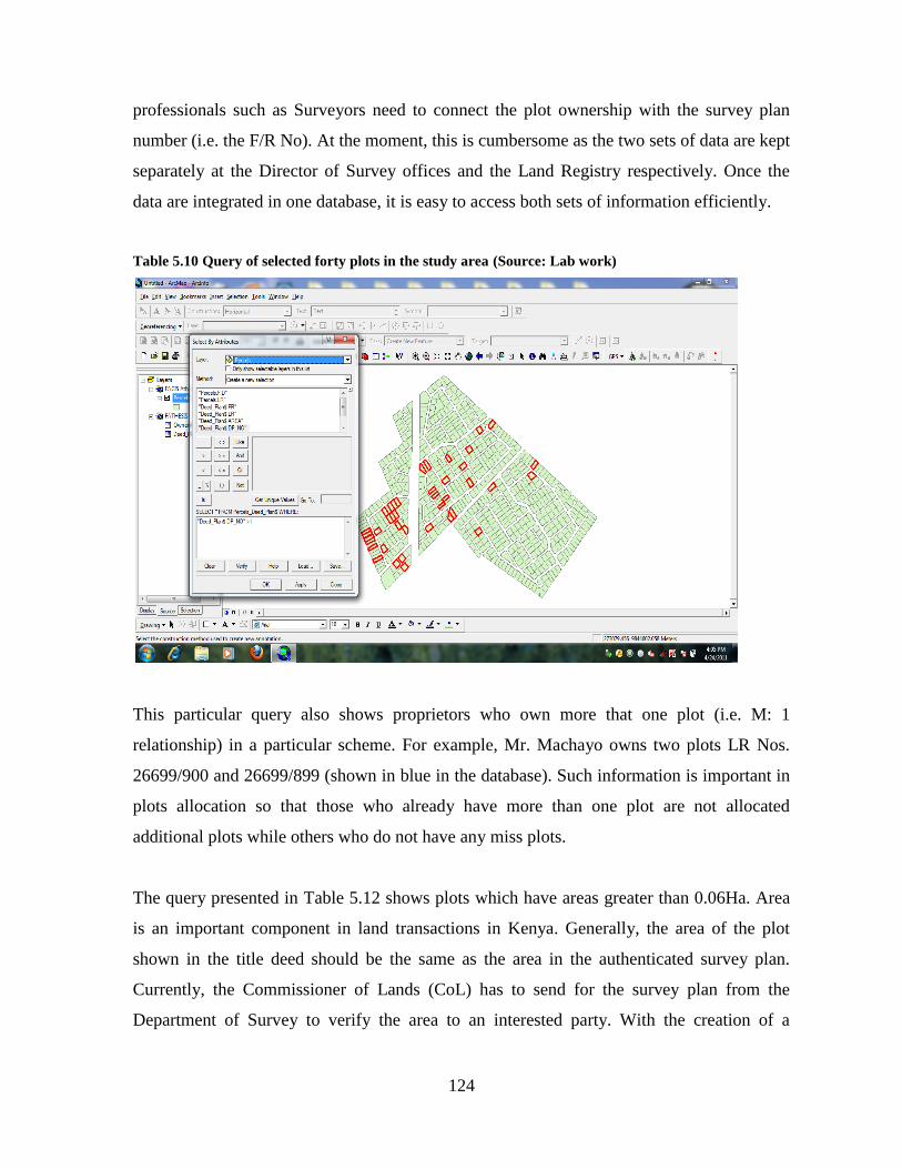
ICT - Information and Communications Technology
SWOT Strengths, Weaknesses, Opportunities and Threats
MVVM Multi Valued Vector Maps
GIS - Geographic Information Systems
MoL - Ministry of Lands
NACHU - National Co-operative Housing Union
UTM - Universal Traverse Mercator
PWD - Public Works Department
PDP - Part Development Plan
RTA - Registration of Titles Act
GoK - Government of Kenya
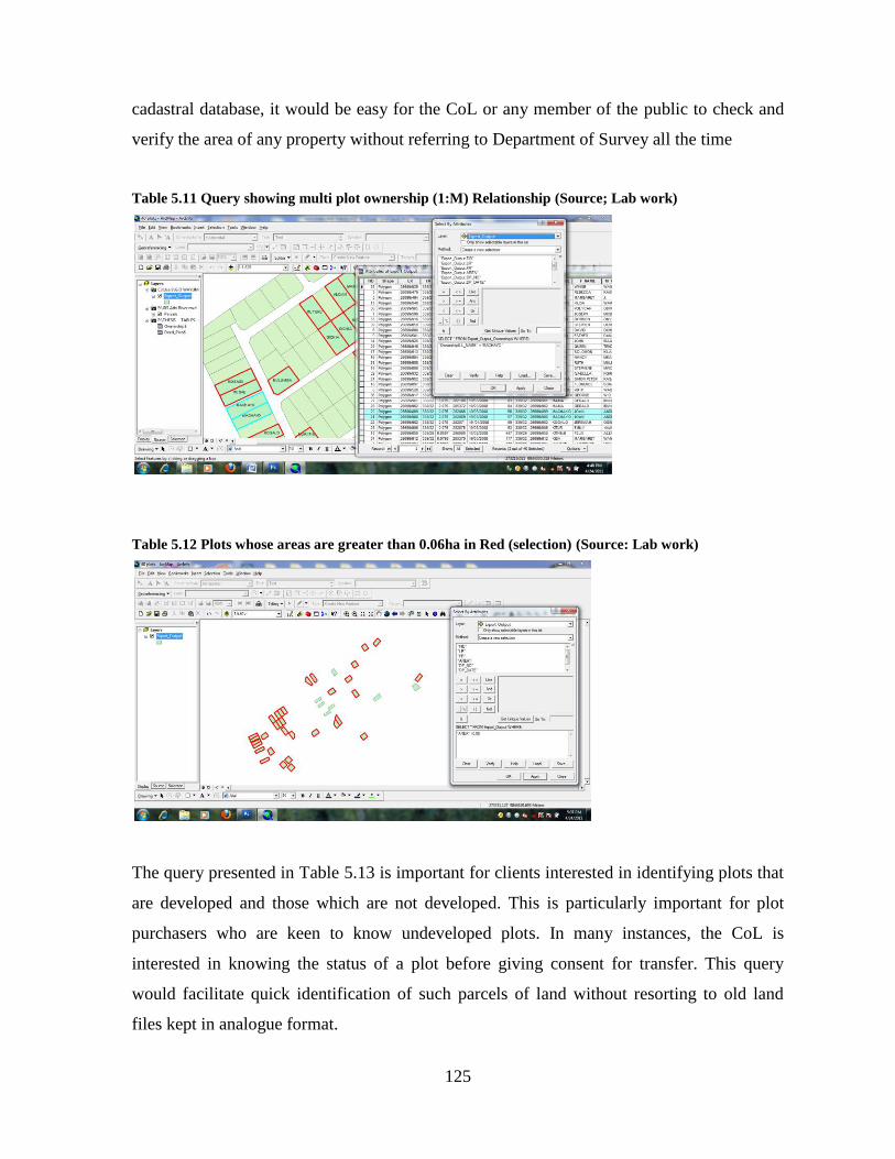
PIDS - Preliminary Index Diagrams
RIMS - Registry Index Maps
RLA - Registered Lands Act
xiv
IBEA Co - Imperial British East Africa Company
RDA - Registration of Documents Act
LTA - Land Titles Act, Cap 282 of 1908
GLA - Government Lands Act, Cap 280 of 1915
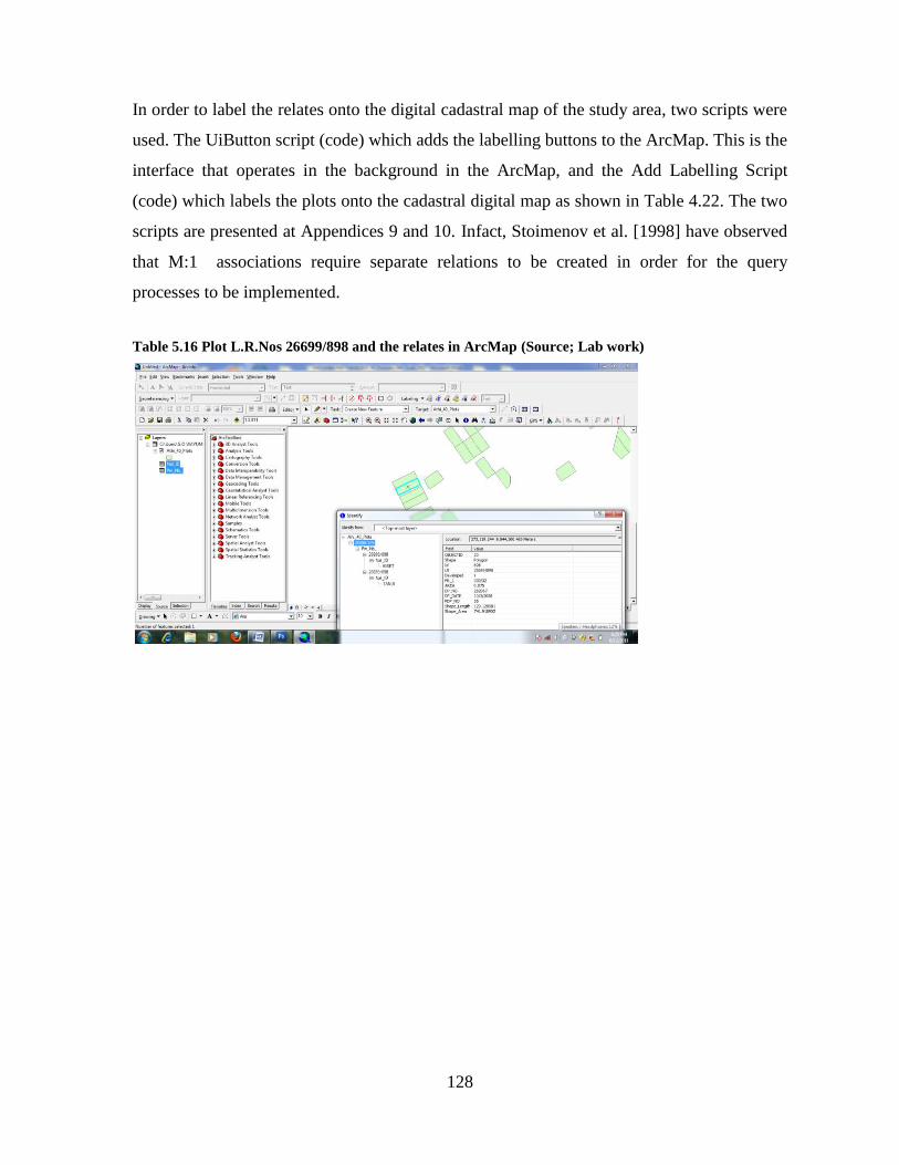
EMCA - Environmental Management and Coordination Act of 1999
NEMA National Environmental Management Authority
L.R No. Land Registry Number
EIA - Environmental Impact Assessment
LCB - Land Control Boards
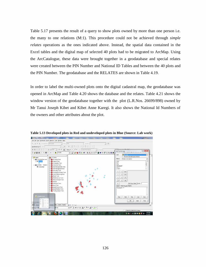
AIA - Appropriation in Aid
SPRO - Senior Plans and Records Officer
DLASO District Land Adjudication and Settlement Officer
RoT - Registration of Titles
LO - Land Officer
I.R. No. Inland Registry Number
C.R No. Coastal Registry Number
ALDEV - African Land Development Report of 1946
MoA - Ministry of Agriculture
SFT - Settlement Fund Trustee
IT - Information Technology
NLIMS National Land Information Management System
SIDA - Swedish International Development Agency
CAMP - Computer Assisted Mapping Project
KeCIS - Kenya Cadastral Information System
KNSDI Kenya National Spatial Data Infrastructure
WSSD - World Summit on Sustainable Development
UNECA United National Economic Commission for Africa
JICA - Japanese International Co-operation Agency
LRTU - Land Rights Transformation Unit
UNCLOS - United Nations Convention on Law of the Sea
EEZ - Executive Economic Zone
MoU - Memorandum of Understanding
UNESCO - United Nations Education and Science Commission
xv
INSIPE Infrastructure for Spatial Information in Europe
ITRF - International Terrestrial Reference Frame
ETRF 89 - European Reference Frame of 1989
RCMRD - Regional Centre for Mapping of Resources for Development
WGS 84 - World Geodetic System of 1984
AFREF African Reference Frame
KENFREF - Kenya Reference Frame
IGS - International Geodetic System
CORS - Continuous Operating Reference Stations
MoL - Ministry of Lands
MoA - Ministry of Agriculture
UN-FIG United Nations- International Federation of Surveyors
UNCED United Nations Conference on Environment and Development
LFA - Logical Framework Approach
SWOT - Strength, Weakness, Opportunity and Threats
ICT - Information and Communication Technology
UTM - Universal Traverse Mercator
STDM - Social Tenure Domain Model
MDGs - Millennium Development Goals
ANSI - American National Standards Institute
SPARC Standards Planning and Requirements Committee
DBA - Database Administrator
DBMS - Database Management System
SACCO Savings and Credit Cooperative Organizations
MVVM Multi Valued Vector Maps
RDBMS - Relational Database Management Systems
OODBMS - Object - Oriented Database Management System
ORDBMS - Object - Relational Database Management System
DML - Data Manipulating Language
SQL - Standard Query Language
FR - Folio Registry
PIN - Personal Identification Number
KRA - Kenya Revenue Authority
xvi
CoL - Commission of Lands
ILIMS - Integrated Land Information Management System
CCDM - Core Cadastral Domain Model
KNBS - Kenya National Bureau of Statistics
ESRI - Environmental Systems Research Institute
GPS - Global Positioning System
xvii
ABSTRACT
The Cadastral system in Kenya was established in 1903 to support land alienation for the white
settlers who had come into the country in the early part of the 20th
Century. In the last hundred
years, the system has remained more or less the same, where land records are kept in paper
format and majority of operations are carried out on a manual basis. The lack of a modern
cadastral system has contributed to problems in land administration in the country.
The Government has expressed the need to modernize the cadastral system in order to facilitate
better land administration, support the development of an integrated Land Information
Management System and a National Spatial Data Infrastructure. However, one persistent
denominator to these efforts has been the lack of strategies for such modernization.
This study set out to contribute to the solution of this problem through the following objectives;
to evaluate the current cadastral system in Kenya, to identify and analyze appropriate
technologies and strategies for modernization of the cadastral system in Kenya, and to test the
suitability of the identified technologies and strategies in the cadastral system.
The Methods adopted included; administration of standard questionnaires to selected
stakeholders, personal interviews, field observations and review of existing literature on cadastre.
Stake holder involvement in the study consisted of private and public sector Land Surveyors,
Lawyers, Valuers, members of Co-operative organizations, and general users of cadastral
information.
The study also carried out field measurements with selected geospatial technologies in selected
study sites to assess their suitability in cadastral mapping and modelling. These technologies
included; Global Positioning System, high spatial resolution satellite imagery, and Geographical
Information System. Further work involved the development and testing a new cadastral model
based on the Multi-Value Vector Maps approach and Smiths Normalization procedures.
The main results from the research are that; the administrative structure is bureaucratic, complex
and highly centralized; the cadastral processes are equally complex, duplicative and slow; and all
the tested technologies were found suitable for cadastral mapping and modelling, however, the
GPS technology lacks proper guidelines for application and calibration bases.
In terms of cadastral modelling, it was found that Smiths Normalization and Functional
Dependency Diagrams automatically produce fully Normalized Tables and successfully query
and display of multi-parcel ownerships. The study also found out that a hyghbrid of Object-
Relational database management system is better-suitable for the development of GIS-based
cadastral databases than typical Relational or Object-Oriented models on their own.
The study concludes that the main problem with the cadastral system in Kenya is lack of
computerization and decentralization, and therefore recommends for a complete decentralization
of the administrative system and implementation of a comprehensive computerization possibly
through the development of a Land Information System.
1
CHAPTER ONE
INTRODUCTION
1.1 General Background
Land and its resources have been the basis of wealth for most societies since the beginning of
civilization. In early Mesopotamia (4000BC), Egypt (3400BC), China (700AD), and Southern
India (1000AD) for instance, land was already a major source of state income through taxation
[Ting, 2002]. Dowson and Sheppard [1952] also observed that during the Roman occupation of
Britain (58 B.C-426 A.D), Emperor Diocletianus ordered surveys and land recordings for
taxation purposes [Steudler, 2004: 8]. Similar situations were found in Northern Germany,
Scandinavia, and areas occupied by the Franks, Frisians and Saxon communities where land
taxation existed based on yields and supported by survey records [Larsson, 2000].
The management of such land resources, while being central to most societies, was varied in
approaches and systems. In England and Wales, for example, the Saxon Kings already had
feudal powers on land while in the Germanic kingdoms, private property was customarily held.
Gradually, land in Germany came under powerful landlords and by the time of Emperor
Charlemagne1 (800-814AD), all land in Europe was clearly headed towards feudalism
[Zweigert and Kotz, 1998].
The Norman2 conquest of England in 1066 AD entrenched the feudal system in Europe while
the Magna Carta3 (1215 AD) was the first revolutionary step towards the establishment of
1 Emperor Charlemagne became King of all of Western Europe by 800AD. He ruled France, Switzerland,
Belgium and the Netherlands; half of present day Germany, Italy and parts of Austria and Spain. By establishing a
central Government over Western Europe, Charlemagne paved the way for modern development in Europe. 2 William, Duke of Normandy invaded England in 1066AD and was crowned King William 1st. He is famous for
compiling the Doomsday book in England in 1086AD; which contained information on land such as; ownership,
acreage, land use, number of tenants and quantity and type of livestock ;but with no maps. 3 The Magna Carter is Latin for the Great Charter. It refers to the English Charter launched in 1212AD and
required the King to proclaim certain rights pertaining to Nobles and Barons. Notable among these was the writ of
habeus corpus. It was the most significant early influence on the extensive historical processes which led to the
rule of constitutional law in Europe and later, the USA.
2
private land ownership [Ting, 2002: 9-11]. The Industrial revolution of the 18th
century in
Europe accelerated the development of the individual land tenure system and introduced
significant land management changes. These included the enclosure movement across Europe
and the United Kingdom, which consolidated the tiny, inefficient, parcels of feudal land into
larger, more productive plots.
This revolution, coupled with the move by the landed aristocracy into industry and the demand
for labour in urban factories, changed the human relationship with land. The society
immediately realized that land was no longer the only primary repository of wealth and identity
as such other assets as industrial practices began to expand considerably. The industrialization
movement also gave rise to capitalism, expanded land markets and saw the onset of major
urbanisation in Europe. England takes credit as the first centre of industrialization due to its
well developed and independent legal system, which provided security of tenure for private
property development [Ting, 2002:18].
Ting and Williamson [1999a] and Enemark [2005] have both observed that the various stages
of land tenure evolution coincided with specific human stages of development. Feudalism, for
example, coincided with the growth of the city-states in Mesopotamia, Egypt, China and India,
while the development of the individual tenure coincided with the onset of industrial revolution
in Europe and the development of land markets. The establishment of the modern cadastre and
the evolution of subdivision schemes coincided with the information revolution.
These changes are dynamic and are driven by the main global drivers such as, urbanisation,
globalisation, economic reforms, environmental management and the need spatially enabled
governance. Pivotal among these drivers is the tension between sustainable development and
environmental conservation. On the one hand, population pressure requires that more land are
converted into residential and urban land use while on the other hand, sustainable development
requires effective incorporation of economic, social, political paradigms, environmental
conservation and resource management principles in management.
3
The challenge of balancing these competing tensions in a sophisticated decision-making
process requires access to accurate and relevant spatial information in a readily interactive
format. In delivering this objective, information technology, spatial data infrastructures, multi-
purpose cadastre and land information systems play critical roles [Williamson, 2000].
Unfortunately, most developing countries still depend on the traditional cadastre to support
their land administration systems.
While these traditional cadastral systems were well suited for the simple agrarian societies, the
sophisticated economies of the 21st century need the services of modern cadastre to effectively
deliver the objectives of sustainable development. Stand-alone approaches that supported
individual purposes are no longer sustainable. These systems are being replaced by multi-
purpose cadastres where information about resources, land use planning, land value and land
titles, including individual and indigenous rights, are integrated into a single geospatial
database for effective utilization [Williamson, 2000: 13].
The need for modern cadastre has been a major concern of the United Nations since its
inception. In 1972, the UN called together an ad-hoc group of experts to study the problems of
cadastral surveying in developing countries and to consider setting up a permanent committee
to constantly review the developments in this area, [UN-FIG, 1996]. Further commitments to
these reforms were demonstrated in the Agenda 21 [UN-FIG, 1998] and the Habitat II Global
Plan of Action [UNCHS, 1996]. At these meetings, it was recognised that efficient and
effective cadastral systems are essential for economic development, environmental
management and social stability in both developed and developing countries.
The Bogor–Declaration [UN-FIG, 1996] established visions for modern cadastral infrastructure
and the two major paradigms that a modern cadastre is supposed to, support long term
sustainable development, land management and service the escalating needs of greatly
increased urban population. The Declaration thus set off a need for a clear vision in dealing
with modern cadastre. These visions were actualized at the 20th
FIG Congress in Melbourne,
Australia in 1994 where “Cadastre 2014” was established to create a vision of how cadastres
would work and look like twenty years from 1994.
4
The main mission of Cadastre 2014 was to develop vision statements indicating where cadastre
as a concept would be in 2014. Cadastre 2014 was published in 1998 and has since been
translated into 22 languages [Steudler, 2004]. The results of the study of Cadastre 2014 were
basically six statements setting the international benchmarks for cadastral systems
internationally. Dale and McLaughlin [1988] pioneered in this area by publishing guidelines
for evaluating a cadastral system and the requirements for implementation of the multipurpose
cadastre. Majority of their recommendations have been incorporated in Cadastre 2014.
Current literature on cadastre [UN-FIG, 1996; UN-FIG, 1998 and UN-FIG, 1999] emphasizes
the importance of Cadastre 2014 as the international benchmark which should guide all
cadastral reforms internationally. Although Steudler [2004] noted that Cadastre 2014 leans
towards a technical rather than legal focus, it offers adequate solutions to the managerial and
political problems of land administration and sustainable development. In its current format,
Cadastre 2014 has contributed significantly towards the development of modern cadastre but is
currently being modified towards Cadastre 2034 to reflect the future cadastral demands
[Bennet et al., 2011].
Today, many countries in the West have moved from the traditional cadastre to modern multi-
purpose cadastre through the implementation of Cadastre 2014. These countries include
Sweden, Denmark, Netherlands, Germany, Canada, USA, Australia and New Zealand among
others. In the majority of the countries, land registries have been modified to include coded
building information and utilities, and land information systems are already web-based.
What is emerging is that while developed countries have moved on to modern cadastral
systems, majority of the countries in Africa are still stuck in the old traditional systems
although a few countries have embarked on the process of modernizing their cadastre in line
with the internationally recognized benchmarks. These include; South Africa, Botswana,
Lesotho, Ghana, Rwanda and Ethiopia, just to mention a few.
5
Kenya, like many African countries, still lacks a modern cadastral system; a situation which
has contributed to several problems in land administration in the country. Some of the major
challenges include; a large amount of manual-based land records which are increasingly
becoming unmanageable and inefficient and bureaucratic and lengthy land transaction
processes which impact negatively on the image of the country.
1.2 Statement of the Problem
The Bogor–Declaration [UN-FIG, 1996] emphasizes that without a modern cadastre blue print,
issues such as Poverty Reduction and Economic Recovery Strategy for Wealth and
Employment creation would not work. Traditional cadastral systems have enjoyed a reputation
for reliability, well defined processes, and organized security of private land ownership.
However recent technological changes, new human land relationships, globalization and
sustainable development requirements have put a major strain on these systems.
In Kenya, the Ministry of Lands plays an important role in the achievements of the aspirations
of vision 20304. Land reforms have been identified as one of the foundations upon which
economic, social and political pillars of Vision 2030 are anchored. Vision 2030 envisages that
land reforms involve the modification or replacement of existing institutional arrangements
governing possession and use of land in order to improve land administration
[wikipedia.org/wiki/Land_reform]. Already the government of Kenya has fulfilled some of
these objectives by enacting new Laws and regulations governing land. These include the
National Land Commission, Land Act, and Land Registration Act among others.
These reforms are aimed at improving access to land and ensuring better utilization of the
natural resources. The Ministry appreciates that the transformation envisaged under Vision
2030 must be anchored on strong policies and legal-institutional framework such as already
entrenched in Chapter Five of the Kenya Constitution, 2010.
4 Vision 2030 is an economic blue-print by which Kenya intends to attain a newly industrializing, middle-income
economy by the year 2030. It is based on three main pillars: Economic, Social and Political.
6
The achievement of these noble goals requires an integrated approach to land development and
an efficient land market. To this extent, Agenda 21 [UN-FIG, 1998] already recognised that the
integrated approach to land development is one of the most important denominators to
delivering the objectives of sustainable development in the 21st century. If Kenya has to
achieve the objectives of sustainable development and Vision 2030, the government needs to
embark immediately on a programme of modernization of the cadastral system as this is the
spatial framework which supports the implementation of such development agenda.
The Ministry of Lands, in its Strategic Plan (2008-2012) and performance contract (2010/2011)
already identified that to ensure effective and efficient service delivery to the clients;
processes, procedures and practices of handling land information need to be re-designed. It
further noted that such re-design should include, Business Process Re-Engineering, and
targeted four bench-marking activities towards achieving these objectives. These four bench-
mark activities included a review and documentation of current processes, procedures and
practices; redesigning procedures and processes of land administration; making
recommendations for quick-win projects; and implementation of a National Land Information
System [MoL, 2011: 17].
Bogaerts and Zevenbergen [2002] however cautioned that restructuring cadastral systems is a
slow and difficult process which requires sensitivity to a country‟s historical and institutional
heritage. It is here that the rights and responsibilities of different sectors of the society do clash
because land restructuring creates changes that affect rights and responsibilities, and therefore
hold possibilities for disagreement. The Bogor-Declaration [UN-FIG, 1996], also
recommended that in order to improve a cadastral system, it is necessary first to identify its
bottlenecks, weaknesses and inefficiencies.
Once these weaknesses have been fully documented and evaluated, it is then possible to re-
engineer the system for efficient delivery of cadastral services to the users. Such re-engineering
often require changes to legislation, modification of institutional and administrative systems,
and the use of geospatial technologies.
7
Therefore from the foregoing discussions, it is evident that the re-design of any cadastral
system, requires a comprehensive evaluation in order to establish its strengths and weaknesses
in order to propose the re-design strategies. At the moment, there has been no comprehensive
study of the cadastral system in Kenya to support fundamental re-thinking and re-design in line
with modern cadastral standards. Additionally, there has not been adequate study to identify
and analyze appropriate technologies and strategies which may support meaningful re-design
of the system.
The discussion presented above indicates a lack of sufficient knowledge on the current status
of the cadastral system in Kenya, and no information on the appropriate technologies and
strategies that can drive the current cadastre into a modern system. Pursuant to these issues, the
following research questions need answers:
What is the current status of the cadastral system in Kenya?
What are the appropriate Technologies and Strategies that can help propel Kenya‟s
Cadastre into a future modern cadastre?
What is the performance of these Technologies in real practical cadastral situations in
Kenya?
Arising from these observations and the above statement of the problem, the objectives of the
study can be stated as follows.
1.3 Research Objectives
The specific objectives of this study are:
To evaluate the current cadastral system in Kenya
To identify and analyze the appropriate techniques and strategies for the future needs of
Kenya‟s Cadastre
To test the suitability of the identified techniques and strategies in the Cadastral
System.
8
1.4 Justification and Relevance
Land is critical to the economic, social and cultural development of Kenya. It is crucial to the
attainment of economic growth, poverty reduction and gender equity. Its importance has been
clearly recognized by various Government initiatives including the National Poverty
Reduction Strategy Programme (1999-2015) and the Economic Recovery Strategy for Wealth
and Employment Creation Programme (2003-2007). Some important issues relating to land
have for a long time not been adequately addressed. These include; access and distribution,
duplicity in the maintenance of the land records, and registration of land rights in the informal
settlements.
In terms of access to land, culture and traditions continue to support male inheritance of family
land while there is lack of review of gender sensitive family laws. There is conflict between
constitutional and international protocols on gender equality vis-à-vis customary practices that
discriminate against women in relation to land ownership and inheritance. Apart from women,
several groups in Kenya have not had adequate access to land. These include minority
communities, pastoral communities, the disabled, the poor and the marginalized groups.
Sessional Paper No.3 of 2009 on National Land Policy however taken care of this
discrimination and now both men and women have equal rights on land rights.
In terms of land use planning, some of the major problems inadequately addressed in the land
administration system; unsustainable production from agricultural land, inadequate land use
planning, poor environmental management, and poor ecosystem protection. The major
challenge facing the Government is the facilitation and integration of multi-sectoral approach
to land use in both the urban and rural environments. This is partly due to the uncoordinated
approach to land use planning and partly due to the duplication of planning services in the land
administration sector. Additionally, the challenges are complicated by the duplicity in the
management land information in the country.
Institutions managing land in Kenya are varied and may. These include the Ministry of Lands,
the Local Authorities, Ministry of Environment and Natural Resources, Kenya Wildlife
9
Service, various parastatal organizations and United Nations Organizations. UNCHS [2001]
observed that with the expanding user requirements, the system has become cumbersome and
fraught with delays in searches. Additionally, it is an inefficient and time-consuming systems
with complicated planning, zoning and overall management of land.
The informal settlements, on the other hand, have also emerged as a new tenure system in both
the rural and urban areas in Kenya. This is mainly because; the production of low-cost housing
in the urban areas has been hampered by the high building standards required by local
authorities, scarcity of land appropriately zoned for such development, and the development of
housing which is biased towards middle and upper income groups [NACHU, 1990]5.
To address these problems, the government recently adopted Sessional Paper No.3 on National
Land Policy to guide the country towards a sustainable and equitable use of land. The policy
intends to address the critical issues of land administration, access to land, land use planning,
restitution of historical injustices, environmental degradation, conflicts, unplanned proliferation
of urban informal settlements, outdated legal framework, institutional framework and
information management. It recognizes the need for security of tenure for all Kenyans and
promotion of multi-sectoral approach to land use planning and enabling environment for a
sustained economic growth.
Secure land tenure has been identified as a critical factor in increasing productive investments
in the urban and rural areas, and encouraging sound and sustainable management of land and
natural resources. It also enables the poor to contribute to, and benefit from, processes of
economic growth and transformation. According to the Bogor Declaration [UN-FIG, 1996], to
achieve sustainable resource management and the development of future world population
explosion, secure land tenure systems and effective cadastral structures must be available.
Larsson [2000] and Osterberg [2001] also recognized that accurate and reliable land
information systems are fundamental to the economic development of any nation.
5 NACHU is the National Cooperative Housing Union Ltd. An NGO under the Ministry of Co-operatives
concerned with the up-grading of the informal settlements in Kenya.
10
The Bathurst Declaration [UN-FIG, 1999] observed that developing countries are experiencing
a massive migration of population into the urban areas, where poor people are increasingly
concentrated in slums and informal settlements. It is estimated that, in these countries, 88% of
the population growth during the next 25 years will be in urban areas [UNCHS, 1996]. Kenya
is not an exception to these population growth scenarios. Already, the city of Nairobi alone
accounts for about 10% of the National population and it is estimated that 60% of this
population lives in the informal settlements. Conflicts and competition for land are bound to
increase unless a proper land management strategy is put in place.
The Habitat Agenda, on the other hand, emphasizes that access to land and legal security of
tenure are strategic prerequisites for the provision of adequate shelter and for the development
of sustainable human settlements in the urban areas. Agenda 21 [UN-FIG, 1998] observes that
plans, policies and actions for sustainable development depend on access to appropriate spatial
information. These observations justify the re-engineering of the traditional cadastral systems
into modern cadastre.
The success of a digital cadastre is highly dependent on the data structure, analysis and
conceptual data modelling. Within the realm of a Geographic Information System (GIS), data
included in the data model, have the longest life span and is the most expensive. Lemmen et al.
[2003] observed that cadastral modelling is a basic tool facilitating appropriate systems
development and re-engineering. Modelling also forms the basis for meaningful
communication between parts of the cadastral system. Tuladhar [2002] also justified the use of
cadastral models as an instrument for assessing user requirements and understanding the
existing cadastral system.
Cadastral data modelling is therefore instrumental in the following areas; the establishment of a
digital cadastre, filling in legislative gaps, document emerging relationships between
humankind and land, and improving the database integrity by maintaining logical, temporal
and topological consistency. Cadastre 2014 in its statement number three clearly states that the
future cadastre will depend on modelling rather than maps and there will be no draftsmen in
11
the new cadastral systems. The establishment of a multi-purpose cadastral database therefore
offers an invaluable contribution towards the modernization of the Kenya cadastre.
1.5 Scope and Limitations of the Thesis
Specifically, the parameters chosen for evaluation include technical and legal aspects. Apart
from these performance indicators, other parameters that are considered include; security,
simplicity, timeliness, accessibility, and sustainability.
Cadastre 2014 Model has listed six statements which present where cadastral systems should
be by the year 2014. These statements have a strong impact on the development and
performance of cadastral systems and were therefore considered in the evaluation process. The
main parameters evaluated from the Cadastre 2014 Model included; the legal situation of the
cadastre including rights, restrictions and responsibilities, spatial data integration, level of
cadastral modelling, private and public partnership, and cost recovery.
In terms of the identification of the appropriate technologies and strategies, the study confined
itself to the assessment of selected modern equipment such as; GPS, High Spatial Resolution
Remote Sensing Satellite Imagery Cadastral Database model, and Geospatial Information
Systems. Thurston et al. [2003] have identified that in modern times, these are the most crucial
technologies that define the future of the cadastre and understanding how they perform in
terms of cadastral mapping has a great bearing on assessing the level of modernization of the
cadastre itself.
1.6 Significance of the Study
The study addresses the problem of the status of the cadastral system in Kenya and how it can
be re-designed for future relevance. The output from the study will provide a comprehensive
documentation of the system for the first time in almost a hundred years. Such a document is
essential in the re-designing the system to provide better services to the users.
12
In assessing the modern geospatial technologies, the study will provide a basis for; assessing
the accuracy of GPS as a cadastral mapping tool, the suitability of satellite imagery in cadastral
mapping in terms of resolution, and the GIS Database system as a tool for data integration. The
findings of this study are therefore key in the re-designing and operation of the future Kenya‟s
cadastre.
Although the study uses Cadastre 2014 as the international Benchmark, it is observed that the
international community has proceeded and designed a new cadastre expected in 20 years from
cadastre 2014; Cadastre 2034. The findings of his study will provide a basis for re-organizing
the Kenya cadastre towards the future cadastre models.
1.7 Definition of Key Terms
Modernization: In the context of this thesis, modernization means the process of re-
engineering a traditional cadastral system into multipurpose cadastre in line
with the requirements of Cadastre 2014 and Future Cadastre such as the
proposed Cadastre 2034.
In re-engineering cadastral systems, Dale and McLaughlin [1988] have
emphasized that four particular areas need a close scrutiny and proceeded to
summarize the four areas as; adjudication and the demarcation of rights in
land, determination and demarcation of boundaries, conduct of surveys, and
parcel description and recording.
Land: Land is defined as the basis of all wealth. It is the ultimate resource, for without land,
life on earth cannot be sustained. Land is both a physical commodity and an abstract
concept in that the rights to own or use land are as much a part of the land as the objects
rooted in its soil [UN-ECE, 1996:10]. The Bathurst Declaration [UN-FIG., 1999] further
notes that land as a scarce and fragile resource is an object of environmental protection.
13
Land is equally an asset for economic and social development. As an object with secure
land rights, it has the capacity to underwrite and accelerate economic development through
the treatment of land rights as a marketable commodity. Its capacity for wealth generation,
for attracting and locating investment, and for opening opportunities for development of
the financial sector, is critical to socio-economic development.
A Cadastre: A cadastre is a parcel based, up-to-date land information system containing a
record of interests in land (e.g. rights, restrictions and responsibilities). It includes a
geometric description of land parcels linked to other records describing the nature of the
interests, the ownership or control of those interests, and often the value of the parcel and
its improvements. It may be established for fiscal purposes (e.g. valuation and equitable
taxation), legal purposes (conveyancing), to assist in the management of land and land use
(e.g. for planning and other administrative purposes), and enables sustainable development
and environmental protection [UN-FIG., 1995].
A Cadastral Survey: A cadastral survey is the term used to describe the gathering and
recording of data about land parcels. Cadastral surveys are concerned with geometrical
data, especially the size, shape, and location of land parcel. The results of a cadastral
survey are isolated plans of a parcel or a subdivision [Steudler, 2004:24].
Land Registration: Land Registration is defined as the process of recording legally
recognized interests (e.g. ownership and use) in land [Zevenbergen, 2002: 27]. The term
registration refers to an active process, whereby the result should be called a register and an
organization doing this is referred to as a Registry. Land Registration refers to a
predominantly legal registration, where one can see who owns some real property. It
contains the relevant legal documents regarding real property.
Land Administration: Land Administration is the process of determining, recording and
disseminating information about the tenure, value and use of land when implementing land
management policies. It is considered to include land registration, cadastral surveying and
14
mapping, fiscal, legal and multi-purpose cadastre and land information system [UN-ECE,
1996].
1.7 Organization of the Thesis
The thesis is divided into six chapters as follows:
Chapter One introduces the subject, presents the problem statement, research objectives,
scope, significance of the study, definition of terms and the organization structure.
Chapter two addresses the subject of Evaluation of the structure of the cadastral system in
Kenya and its processes. Under the structure, issues addressed include, the organizational
structure, tenure systems, boundaries, and registration systems. The processes addressed
include; allocation of Government land and Trust Lands, Land Adjudication programmes,
land registration and subdivision of both urban and rural lands in Kenya.
Chapter three presents a review on the search for a modern cadastral system. This chapter
basically dwells on the identification of the appropriate technologies and strategies for
modernizing the cadastral system in Kenya. It reviews the achievements and challenges of
the current system and looks at the international benchmarks upon which modernization
should be anchored.
Chapter Four deals with research design, methodology of data collection, categories of data
collected, and methods of analysis of the same.
Chapter Five presents data findings and Analysis. Here, the results of the study from
various sources data collected are presented and analyzed.
Chapter six is the final chapter of this thesis which presents the conclusion of the study.
Included in here are the conclusions, recommendations of modernization strategies, areas
of further research and significant contributions of the study to the body of knowledge.
15
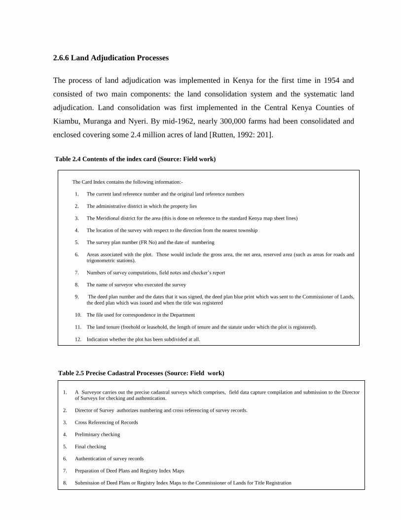
CHAPTER TWO
THE CADASTRAL SYSTEM IN KENYA
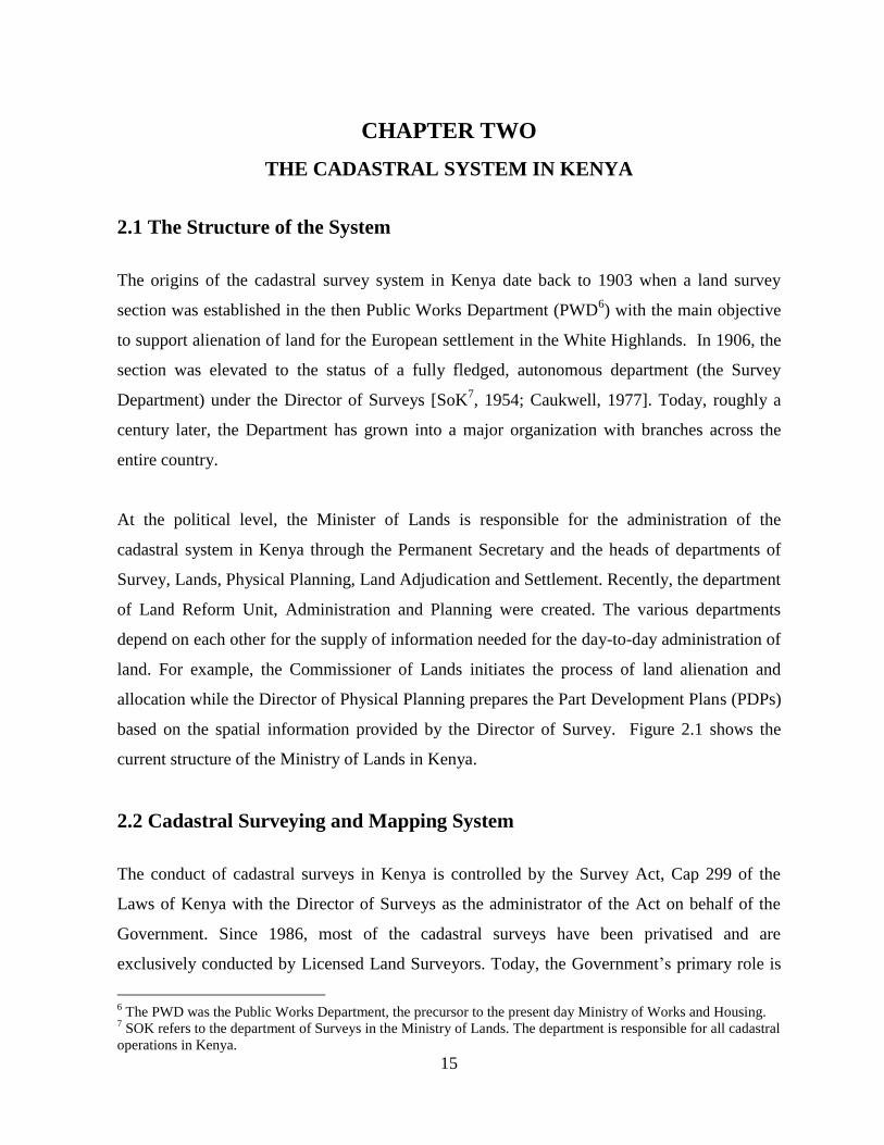
2.1 The Structure of the System
The origins of the cadastral survey system in Kenya date back to 1903 when a land survey
section was established in the then Public Works Department (PWD6) with the main objective
to support alienation of land for the European settlement in the White Highlands. In 1906, the
section was elevated to the status of a fully fledged, autonomous department (the Survey
Department) under the Director of Surveys [SoK7, 1954; Caukwell, 1977]. Today, roughly a
century later, the Department has grown into a major organization with branches across the
entire country.
At the political level, the Minister of Lands is responsible for the administration of the
cadastral system in Kenya through the Permanent Secretary and the heads of departments of
Survey, Lands, Physical Planning, Land Adjudication and Settlement. Recently, the department
of Land Reform Unit, Administration and Planning were created. The various departments
depend on each other for the supply of information needed for the day-to-day administration of
land. For example, the Commissioner of Lands initiates the process of land alienation and
allocation while the Director of Physical Planning prepares the Part Development Plans (PDPs)
based on the spatial information provided by the Director of Survey. Figure 2.1 shows the
current structure of the Ministry of Lands in Kenya.
2.2 Cadastral Surveying and Mapping System
The conduct of cadastral surveys in Kenya is controlled by the Survey Act, Cap 299 of the
Laws of Kenya with the Director of Surveys as the administrator of the Act on behalf of the
Government. Since 1986, most of the cadastral surveys have been privatised and are
exclusively conducted by Licensed Land Surveyors. Today, the Government‟s primary role is
6 The PWD was the Public Works Department, the precursor to the present day Ministry of Works and Housing.
7 SOK refers to the department of Surveys in the Ministry of Lands. The department is responsible for all cadastral
operations in Kenya.
16
that maintaining supervisory role and ensuring quality control in the execution of the surveys
through the enforcement of a Code of Ethics and the Survey Act through the Land Surveyors
Board.
As a result of surveys which have been carried out in the country since 1903, large amount of
cadastral data have been generated over the last 100 years. These include survey plans, field
notes, computations, registry index maps, aerial photographs, topo-cadastral maps, the 1:
50,000 adjudication boundary maps, deed plans and title deeds. Majority of the records are
kept by the Director of Surveys except for copies of title deeds which are kept by the
Commissioner of Lands. According to Njuki [2001], about four million hectares of land have
been surveyed and registered under the precise cadastral survey system since 1903.
2.3 The Cadastral Boundary Systems in Kenya
Kenya operates three types of boundary systems: fixed boundary, general boundary and the
fixed general boundary. These boundary definitions are either based on the English general
boundary system as practised in Britain under the Land Transfer Act of 1875 [Larsson, 2000:
42] or the fixed boundary system based on the Torrens8 system from Australia [Larsson, 2000;
Steudler, 2004]. The fixed-general boundary has been adopted to achieve fixation of the
general boundaries in areas where the land markets have appreciated.
2.3.1 The Fixed Boundary
The fixed boundary system is one which has been accurately surveyed so that any lost corner
monument can be re-established precisely from mathematical measurements. Monumentation
for fixed boundary surveys consist of coordinated beacons at the turning points of rectilinear
boundaries. Natural features such as rivers, roads, and ocean line, may also be adopted as
curvilinear boundaries. All fixed cadastral surveys from all over the country are examined and
authenticated by the Director of Surveys in Nairobi. Under the fixed boundary system, all the
parcels have their plans indicating area, bearings and distances between the boundary beacons.
8 Sir Robert Torrens, a graduate of Trinity College Dublin, introduced a land title registration system in Southern
Australia in 1858. This system was introduced in Kenya in 1919 and was supported by the Registration of Titles
Act.
17
Where surveys are carried out under the Registration of Titles Act (RTA)9 for the
establishment of fixed boundaries, the surveyor prepares deed plans with respect to each plot,
which, after signing and sealing by the Director of Surveys, are forwarded to the
Commissioner of Lands to support registration [Mwenda, 2001]. Areas which were surveyed
under the fixed boundary method: new grant allocations, urban leases, Trust Lands that have
been set-apart for public use, Forest Reserves, National Parks and National Game Reserves,
and company and cooperative farms where shareholders opt for a fixed survey.
Fixed boundaries have the advantage of easier relocation and re-establishment, especially
where physical boundary marks are missing. For a long time, the fixation of these boundaries
was optional. However, with the enactment of Land Registration Act No. 3 of 2012, it is now
mandatory that all survey boundaries presented for registration must be georeferenced. This
has the effect that from the date of the enactment of the Act, the general boundary system is
extinguished. Although no reliable figures are currently available, it has been estimated that the
total number of properties under the fixed boundary system are approximately 300,000; and the
total area so is 3.4 million hectares [Mwenda, 2001].
2.3.2 The General Boundary
The term general boundary means that the exact location of the boundary is undetermined but
assumed to be represented by a visible physical feature such as hedges, walls, rivers or
streams, coastlines, or any physical feature that may be found suitable for the definition of the
position of the boundary. The concept of general boundaries was introduced in Kenya in 1959
by the Native Lands Registration Ordinance and the registry map was intended to be used as
the index map [GoK, 1966: 70].
The use of general boundaries was adopted to demarcate newly adjudicated land parcels in the
former Native Reserves. At the time of implementation of the general boundary system (in
9 The Registration of Titles Act, Cap 281 was enacted in Kenya in 1919 to register the newly surveyed White
Settler Community land in Kenya. Most of these settlers required secured title rights which they could use as
collateral in England to acquire loans for land development. The RTA is still used in many parts of Kenya up to
the present day.
18
1954) the needed to speed up land registration in the Native Reserves as the indigenous
inhabitants had not received any title to land since 1903 when the cadastral system was
established.
Fig 2.1 Current Structure of the Ministry of Lands (Source: Department of Surveys, 2009)
In creating the general boundaries, landowners were then asked to mark the boundaries of the
plots by planting hedges as guided by the demarcation officers. Once the hedges had grown
sufficiently, aerial photographs were taken at the scale of 1:12,500 and further enlarged to
Administration
and Planning
ICT Unit
Central Planning and Monitoring
Unit
Procurement
Unit
Finance
Unit
Accounts
Section
Human
Resource
Department of
Surveys
Cadastral
Division
Adjudication Survey
Division
Geodetic & GIS
Division
Mapping
Division
Hydrographic
Surveys Division
Administration & District
Offices
Department of
Physical
Planning
Regional
Planning
Development
Control
Forward
Planning
Enforcement
Section
Administration & District
Offices
Land Reform
Technical Unit
LIMS Function
Education and
Public Awareness
Function
Legal
TWG
Institutional
Reform Function
Land
Management
TWG
Administration
& District
Offices
Minister
for Lands
Permanent
Secretary
Dept. of Land
Adjudication
and Settlement
Settlement
Division
Land Adjudication
Division
Administration & District
Offices
Administration
& District
Offices
Department of
Lands
Land Administration
Division
Valuation
Division
Land Registration
Division
19
scales of 1:5000 or1:2,500 to facilitate the generation of representative Preliminary Index
Diagrams (PIDs)10
.
The aerial photographs initially generated were meant to be subsequently ortho-rectified in
order to eliminate geometric distortions and produce more reliable representations of the land
parcels [Adams, 1969]. This was to be accomplished through the re-fly11
of the areas under
adjudication. However, after coverage of a few areas, the refly system was abandoned in 1967,
largely due to shortage of funds and high demand for titles. The Lawrance Mission12
also
recommended for the abandonment of the re-fly programme (in the consolidation areas) in
order for the survey staff to concentrate in the new, accelerated, adjudication programmes
[GoK, 1966: 61].
The general boundary surveys are lodged and processed at the District Survey Offices. Once
the surveys have been checked and found acceptable, the Registry Index Maps (RIMs) are
amended by the District Surveyor and the amended plans are forwarded to the District Land
Registrar for preparation of titles. Several generic forms of the RIMs exist in Kenya, depending
on the nature and accuracy of survey. These are the Interim Registry Index Maps, the
Demarcation Maps, Registry Index Maps Provisional, Preliminary Index Diagrams and
Registry Index Maps-Range Provisional [Mwenda, 2001].
Areas covered by the general boundary surveys are: (i) areas where land Adjudication and
consolidation surveys have taken place; (ii) group ranches where the shareholders opt for a
general boundary survey; (iii) company and Cooperative Farms where the shareholders opt for
a general boundary; and (iv) settlement schemes acquired from the former white settlers.
Available statistics in the Ministry of Lands show that general boundaries currently cover
approximately 11 million hectares of land (comprising of 1.5million parcels and 338 group
ranches) [Myles et al., 2009].
10
Preliminary Index Diagrams (PIDs) are the tracings of land parcels images from enlarged un-rectified aerial
photographs which served as interim cadastral maps in support of rapid land titling [Nyadimo, 2006]. 11
The reflies were the fully rectified aerial photos taken after the hedges had grown substantially to be air visible. 12
Lawrance Mission was a government sponsored Mission in 1965-1966 to investigate ways of how land
adjudication programme could be speeded up
20
2.3.3 The Fixed General Boundary
Sections 21 and 22 of the Registered Land Act (RLA) give the Chief Land Registrar the
authority to cause a general boundary to be fixed by surveying to the level of a fixed survey.
The areas where fixed general boundaries apply are: (i) company and cooperative farms, where
the shareholders have opted for a fixed boundary survey; (ii) group ranches where the
shareholders have opted for a fixation survey; and (iii) areas where boundaries were previously
surveyed under general boundaries but the clients later opted for a fixed survey to improve on
the relocation and re-establishment of boundary beacons.
The procedures involved in the fixation of general boundaries generally consist of notifying the
District Land Registrar of the intention to have the boundary fixed. The Land Registrar informs
the abutting neighbours of the intention to have the boundary fixed and if any objection is
raised, the matter has to be referred to the Land Control Board, otherwise the survey is
executed and the Land Registrar certifies (on the survey plan) that the boundary has been fixed.
Such plans are submitted to the Director of Surveys for checking and authentication in line
with the requirements of the Survey Act. The fixation of general boundaries assists in
mathematical re-establishment of the boundary beacons, minimization of potential boundary
disputes and raises the market value of the land.
2.4 The Land Tenure Systems in Kenya
Kenya operates five main land tenure systems: the Public Tenure, Private Tenure, Customary
Tenure, the Informal Tenure and the Ten-Mile Coastal Strip. While the customary tenure
dominates most of the rural lands in Kenya, the private and public tenure systems control land
in the urban areas. The informal tenure is dominant in the urban areas as well as in several
large scale farms in the country in the form of squatters. The Ten Mile Coastal Strip is found
only in the coastal area of the country and has the longest history of all the tenure systems in
Kenya.
21
2.4.1 The Public Land Tenure
According to the Sessional Paper No.3 of 2009 [GoK, 2009: 16] public land comprises all that
land that is not private land or community land, or any other land declared to be public land by
an Act of Parliament. Currently, any surveyed public land is registrable under the Permanent
Secretary for the Ministry for Finance.
All public land were originally, administered under the Crown Lands Ordinance of 1902 and
the Government Lands Act Cap 280 of 1915. These lands were vested in the President of the
Republic of Kenya who over the years had powers to allocate or make grants of any estate,
interest, or rights, in or over unalienated government land. However, with the promulgation of
the new Constitution this power is now vested in the National Land Commission.
To secure tenure to public land, the Government has carried out the following actions;
repealed the Government Land Act and established a Land Registration Act which has taken
over all the registration aspects of the GLA, established a Land Act under the National Land
Commission which will identify and keep an inventory of all public land. Additionally, the
National Land Commission will establish the office of the Keeper/ Recorder of Public Lands
who will prepare and maintain a register of all public lands and the related statistics. The
National Land Commission will also establish a Land Titles Tribunal to determine the bona
fide owners of land that was previously public or trust land.
2.4.2 The Private Land Tenure
There are two major forms of private land ownership in Kenya: freehold and leasehold. Most
of the land parcels held under freehold have been created through land adjudication and
consolidation or allocation of government land for private development. At present, freehold
land are found in areas where land has been converted from trust land to individual tenure
mainly through the process of land adjudication and consolidation. In Nairobi, pockets of
freehold land are found in areas which were originally owned by the Imperial British East
African Company (the IBEACo)13
13
The IBEACo was a Bombay based Imperial East Africa Company (in India) that was granted a charter by
Queen Victoria in 1885 to operate, open, and administer the East African Territory from the coast inland on behalf
22
Leaseholds are interests in land granted for a specific period of time. In Kenya, leases may be
granted for 30, 33, 50, 99, 999 and 9999 years. The 99 years and 33 years leases may be
granted by the Commissioner of Lands for urban plots. The 30 and 50 year leases are granted
by the Local Authorities. The 999 year leases were granted to the white settlers in 1915 under
the Government Lands Act. At the moment, 20% of land in Kenya is estimated to be under
private tenure system [Njuguna and Baya, 2001]. The 9999 year leases are found in parts of the
Coast Province, the former white highlands and Nairobi area. These are special leases that
were granted alongside the 999 years leases. The Constitution of Kenya 2010 fixes the
maximum time for leases in Kenya at 99 years. Consequently, all leases with a time-frame
above 99 years will be reviewed accordingly.
2.4.3 The Customary Land Tenure
Customary land tenure is the system of land holding and land use which derives from the
operations of the traditions and customs of the people affected. Customary law derives from
the accepted practices of the people and the principles underlying such practices [Ezigbalike
and Benwell, 2007]. The most important feature of customary land tenure is the dominance of
community land-right institutions which control how land is used and disposed.
In Kenya, this tenure system refers to unsurveyed land owned by different communities under
customary laws. Being a diverse country in terms of its ethnic composition, Kenya has multiple
customary tenure systems, which vary mainly due to different climatic conditions and
agricultural and cultural practices. The tenure system is currently governed by the Trust Land
Act Cap 288 of 1939.
At present, land under customary tenure occupies approximately 70% of the total area of the
country and most of these lands are gradually being converted to private tenure through the
process of land adjudication. Customary tenure systems are generally mixed with other tenure
of the Queen; and Sir William Mackinnon was given the responsibility of managing the company. The IBEACo
failed due to poor infrastructure and lack of structured public administration in the region and handed over its
operations to the East African Protectorate in 1895.
23
systems in the Group Ranches14
, the Trust Lands and the Ten-Mile Coastal Strip. With the
promulgation of the Constitution of Kenya 2010, all land transactions in the Trust Lands will
be governed by the new Community Land Act 2013.
2.4.4 The Informal Land Tenure
Informal land tenure refers to a situation where the actual occupation and use of land is without
legal basis. Under this arrangement, groups of people occupy public or private land without the
permission of the owner. In Kenya, such situations normally occur in the urban areas where
rapid urbanization outstrips the capacity of the urban management to deliver sufficient and
affordable housing.
The production of low-cost housing affordable to low-income migrants has not kept pace with
the spread of the informal settlements due to; high building standards required by the local
authorities, scarcity of land appropriately zoned for such development, and development of
housing biased towards the middle-class and upper income groups. Available statistics
[NACHU15
, 1990] indicate that currently, 60% of Nairobi residents live in the informal
settlements
For a long time, the Law in Kenya did not recognize the existence of this tenure. However,
since the promulgation of the new constitution, informal tenure has been recognized in law and
the government has put in place mechanisms for the provision of secure tenure for the informal
settlements through the Kenya Informal Settlements Improvement Programme (KISIP) [MoH,
2010]
2.4.5 The Ten-Mile Coastal Strip
The Ten-Mile Coastal Strip in Kenya is a piece of land approximately ten nautical miles wide
from the high water mark of the Indian Ocean. It covers an area of 5,480.44 square km and is
14
Group Ranches are as special form of communal tenure established under the Land [Group Representatives]
Act of 1968 and granted to a group with common customary rights over a defined piece of land. 15
NACHU is the National Cooperative Housing Union Ltd. An NGO in the Ministry of Housing concerned with
the upgrading of the informal settlements in Kenya.
24
approximately 536 km long, stretching from the mouth of River Umba at the Kenya-Tanzania
border to Kipini at the mouth of River Tana, and the Lamu Archipelago.
The land tenure system in the Ten-Mile Coastal Strip has been dictated by the changing
political circumstances in the area. Under the East African Regulations of 1897, people living
in the Ten-Mile Coastal Strip were issued with certificates of ownership for a term of 21 years
in the form of short-term leases. In 1902, land in the Ten-Mile Coastal strip was considered as
government land, and therefore available for alienation under the Crown Lands Ordinance.
However, without some specific legal process, it was difficult for the government to separate
land available for alienation and private land claimed by the Arabs [Okoth-Ogendo, 1976].
A provision for land claims within the Ten-Mile Coastal strip was therefore made possible in
1908 through the Land Titles Ordinance; which was specifically enacted to adjudicate the land
rights in the area in order to separate private land from crown land. A land court, consisting of
a recorder of titles, a surveyor and administrative officers was set up to listen to and determine
the claims. The duties of the Recorder of Titles included boundary surveys and the preparation
of maps to be attached to the certificate of ownership. The Surveyor and the administrative
officers only received the claims. The process of adjudication was therefore solely left to the
Recorder of Titles [Okoth-Ogendo, 1976].
During the adjudication process, most of the land parcels claimed by the landlords as private
property were actually occupied by the indigenous people. The government is therefore
currently faced with a complicated situation where majority of the indigenous people in the
Ten-Mile Coastal strip do not have secure titles to the land while the absentee landlords, who
hold the titles, are not residing on the parcels but are charging fees to the occupants on what the
indigenous communities consider as their ancestral land.
2.4.6 A Critique of the Land Tenure System in Kenya
Some of the problems that have been observed in the current land tenure system can be
summarized as follows; the high to medium potential zones are dominated by small farm
25
holdings which are not economically viable. In some cases, insecure land tenure systems have
led to low investment in land improvement and productivity. Many small-holder areas are
suffering continuous fragmentation of land holdings into uneconomic sizes, and farms are
getting smaller in the high rainfall areas.
2.5 Land Registration Systems in Kenya
Land registration system in Kenya is conducted in two main systems: the deeds registration
and title registration systems. The deeds registration system was the earliest form of
registration introduced by the Colonial government towards the end of the 19th
Century. The
system is governed by Part XII of the Crown Lands Ordinance of 1902 (repealed in 1910 by
the Land Titles Act Ordinance and in 1915 by the Government Lands Act), the Registration of
Documents Act (RDA), Cap 285 of 1901, the Land Titles Act, Cap 282 of 1908, and the
Government Lands Act, Cap 280 of 1915.
Title registration is governed by the Registration of Titles Act (RTA), Cap 281 of 1919, and
the Registered Land Act (RLA) Cap 300 of 1963. More recently, in 1987, the Sectional
Prosperities Act No.21 was enacted to provide ways and means of registering sectional
properties including flats. The latest addition to land registration in Kenya is the new Land
Registration Act No 3 which was enacted on 2nd May 2012. The Act is supposed to revise,
consolidate and rationalize the registration of titles to land. It is also supposed to give effect to
the principles and objects of the devolved government in land registration and other related
issues.
The commencement of this Act repeals the existing registration Acts such as; the Indian
Transfer of Properties Act of 1882, the Government Lands Act Cap 280 of 1915, the
Registration of Titles Act Cap 281 of 1919, the Land Titles Act Cap 282 of 1908, and the
Registered Land Act, Cap 300 of 1963. In addition to the Land Registration Act, other Acts
which affect land registration in Kenya are the National Land Commission Act No. 5 of 2012,
and the Land Act No. 6 of 2012.
26
2.5.1 Registration under RDA
The RDA was the first registration Act in Kenya. It was a simple deeds registration system
introduced in 1901 to register land transactions of the Crown Lands Ordinance and earlier land
allocations16
at the Coast. The Act required that registration of transactions be effected within
six months of execution. A copy of the registered documents was retained in the registry and
an index of names registered was kept. The registration processes under the Act were not
supported by any survey plans hence it was difficult to locate the registered property on the
ground. Under the RDA, the proprietor had to trace the root of the title to the satisfaction of
any intending purchaser.
Initially, registries for the RDA transactions were opened up at Mombasa, Nairobi, Malindi,
and Naivasha. The Malindi and Naivasha registries were closed in 1915 and their records were
amalgamated with Mombasa and Nairobi registries respectively. Two records were established
under the RDA system; the “A” register which was compulsory and the “B” register which was
voluntary. The compulsory register recorded all the transactions in land and immovable
property while the voluntary register was used as a public record of any deeds or other
instruments which might be accidentally lost. The Principal Register of Documents administers
this Act.
The RDA is basically an optional registration system where titles are registered as deeds
without any supporting documents such as, survey plans, deed plans. Apart from land
documents, the system also registers such documents as marriage certificates, deed poll for
change of name, architectural plans, aerial photographs and building plans. The government is
currently in the process of converting all registration systems into the new Land Registration
Act No. 3 of 2012 which has repealed all registration Acts except the RDA.
2.5.2 Registration under LTA
Under the 1887 concessions, the 1894 and 1897 land regulations, and the 1895 land treaties, it
was generally agreed that all existing land rights of the Sultan of Zanzibar within the ten mile
16
Available literature [Caukwell, 1977] indicates that prior to the declaration of the Protectorate status over
Kenya; several land transactions had taken place between the IBEACo and the Sultan of Zanzibar.
27
coastal strip, be recognised and respected by the new colonial administration [Caukwell, 1977].
The Crown Lands Ordinance did not include these lands as Crown Land. The Land Titles
Ordinance was therefore enacted to facilitate adjudication of land claims within the ten nautical
mile coastal strip. Through this process of adjudication, it was possible to identify land which
was legally occupied and the unoccupied land that could be alienated as Crown land.
The Act provided for the establishment of a land Registration Court presided over by a
Recorder of Titles. A surveyor was attached to the court to define the boundaries of the
adjudicated land claims. Upon adjudication by the Recorders Court, the successful claimants
were issued with certificates of title. These certificates, according to the nature of the title
adjudicated, were of three kinds; certificate of ownership, giving a freehold title, a certificate of
mortgage, and a certificate of interest, covering fixed assets on the land, e.g. bore holes, houses
or plants.
2.5.3 Registration under GLA
By 1915, it had become clear to the Colonial government that the Crown Lands Ordinance,
with its six pages of simple provisions, was inadequate to maintain a firm control on land
matters as the protectorate developed [Caukwell, 1977]. The Government Lands Act repealed
the Crown Lands Ordinance of 1902 and authorised the Commissioner of Lands to issue 99
year leases for urban plots and 999 year and 9999 year leases for the agricultural land. Under
the Act, registration of grants and transactions is compulsory; and unregistered documents or
deeds have no validity in Law.
The registries at Malindi and Naivasha, set up under RDA, were closed and the registers in
these stations were transferred to Mombasa and Nairobi. The Act is basically a deeds
registration system supported by authenticated survey plans and approved deed plans. Under
the Act, three registers were opened: one in Mombasa and two in Nairobi. One of the registers
in Nairobi was for land within Nairobi and its environs while the other register was for land in
the European settlements in the White Highlands.
28
Titles registered under the GLA are kept in the registry as volumes and folios (pages) of the
register, with one folio being devoted to each parcel of land. Any transaction over the land
parcels are supported by indentures. Registration system under the GLA is either considered as
Conveyance or Assignment, depending on whether the property is a freehold or leasehold.
Conveyances are freehold titles while the Assignments are leaseholds under the GLA. Under
this system of registration, the owner keeps the original registration documents and only copies
are kept at the Land Registry; which are then used to prepare an indemnity for the government
against loss, damage or alterations.
2.5.4 Registration under RTA
With the promulgation of the GLA in 1915, the white Settlers started to insist on title
registration rather than deeds registration [Okoth-Ogendo, 1991:44]. Thus the introduction of
the RTA was seen as a culmination for the demand of title registration since1896. The RTA
was therefore enacted principally to provide for a title registration system as opposed to the
deeds registration which was practiced under the RDA, LTA and the GLA.
The Act was modelled upon the Torrens system of Australia and partly on the English
Common Law as spelt out in the Land Registry Act of 1862 [Larsson, 2000]. According to the
Lawrance Mission report [GoK, 1966: 65], the Act was not well drafted and by 1927, three
separate committees had recommended for its repeal and replacement but the proposal
disappeared due to the desire to have a uniform registration system for the three East African
countries.
The Act took over all the previously registered deeds under GLA, or those subject to the
certificates of mortgages, or any other interests issued by the Recorder of Titles under LTA and
the RDA. It also applied to all leaseholds that had been converted from the terms of 99 years
since 1902 (or even those of 999 years) to freeholds, and to any titles converted on a voluntary
basis from GLA or LTA to RTA Titles. According to Okoth-Ogendo [1991:44], with the
enactment of the RTA, the disinheritance of the African communities in Kenya, within the
framework of colonial Law, was complete.
29
2.5.5 Registration under RLA
Prior to the enactment of RLA, the government realized that some form of legal framework
had to be developed to support the land consolidation program already in progress in Nyeri
Districts since 194517
[Sorrenson, 1967: 135]. The Native Land Tenure rules of 1956 were
passed under the Native Lands Trust Ordinance of 1939 to give the programme some legal
backing [GoK, 1966:37]. In 1959, the Working Party on African Land Tenure Reforms
recommended the enactment of the Native Lands Registration Ordinance, although its
applications had already been adopted in 1957.
In 1960, the Native Lands Registration Ordinance was changed to Land Registration (Special
Areas) Ordinance. The registration component of this Act was repealed by the Registered Land
Act, Cap 300, of 1963. Parts I and II were not altered and became the Land Adjudication Act
of 1964 [Onalo, 1986: 48]. In 1968, after the Lawrance Mission Report, the name was changed
to Land Consolidation Act Cap 283 of 1968.
The Registered Land Act (RLA) was enacted to provide a complete code of land registration
system in Kenya. It was the objective of the Government that this statute would eventually
replace all the other Acts dealing with land registration in Kenya. At the time of enactment, the
Act superseded the registration provisions of the Native Lands Registration Ordinance of 1959
and the Land Registration (Special Areas) Ordinance of 1960. The Act applies in areas where
land have been surveyed under the general boundaries (as in adjudicated areas), areas where
land have been fixed under Section 22 of the Act; or areas which are being converted from the
RTA to RLA under the Sectional Properties Act.
2.5.6 Land Registration Act No.3 of 2012
This is an Act of Parliament to revise, consolidate and rationalize the registration of title to
land, to give effect to the principles and objects devolved government in land registration, and
connected purposes. This Act has repealed all the previous land registration Acts in Kenya
17
Chief MuhoyaKagumba of North Tetu began land consolidation in his location in 1945 and Chief Elliud Mugo
also started the process in Iria-Ini location in Nyeri at the same time
30
except the Registration of Documents act. Section 7 ( d) stipulates that parcel files containing
the instruments which support subsisting entries in the land register and any filed plans and
documents must be georeferenced.
2.5.7 A Critique of the Registration Systems
The current land registration system has too many statutes dealing with the registration of land.
No attempt has been made to harmonize these statutes to ease the process of registration of
land rights and facilitate speedy access to land registration information. There is therefore a
need to harmonize the registration statutes to enhance the efficiency, transparency and
accountability in the process of land registration.
The Government recently enacted Land Registration Act No. 3 of 2012 to harmonize the
statutes dealing with the registration of land rights. However, there are still no operation rules
and the repealed registration Acts are still in operation. This state of affairs is not conducive to
good business practices and may affect the operations of the land market in Kenya.
2.6 The Cadastral Processes in Kenya
2.6.1 General Introduction
The main cadastral processes discussed in this section cover; the preparation of Part
Development Plans, allocation of government land and trust lands, subdivision of urban and
rural lands, and land adjudication and registration of title. These account for majority of the
precise cadastral processes in Kenya.
2.6.2 Physical Development Plans
The first step in all the cadastral processes is the preparation of development plans; which can
be broadly classified as structural plans and Part Development Plans (PDP). The main
objective of physical planning is to achieve economy, convenience and beauty, and ensure that
the right development takes place [MoL, 1991: 19]. These objectives require regulations,
restrictions and consultations which are vital for the protection of the interest of the general
31
public. In Kenya, all land use planning processes are controlled by the Physical Planning Act,
Cap 286 of 1996 and the Environmental Management and Coordination Act (EMCA) of 1999.
2.6. 3 The Physical Planning Act
This is an Act of Parliament to provide for the preparation and implementation of physical
development plans and for connected purposes. The Act repealed the Land Planning Act Cap
303 and the Town Planning Act Cap 134. The Physical Planning Act of 1996 regulates the
profession of physical planning in Kenya through the Physical Planners Registration Board.
The Act also controls the establishment and composition of the Physical Planning Liaison
Committee in accordance with section 8 of the Act.
One notable fact is that the planning stages presented in Table 2.1 are a bureaucratic, lengthy
and repetitive; a situation which not conform with the demands modern economies. In the
Sessional Paper No. 3 of 2009, the Government proposes to carry out a re-organization in the
Physical planning sector as a means of rationalizing the planning stages and reduce
bureaucracy. The reorganization is expected to cover; a review and harmonization of the
Physical Planning Act (Cap. 286) and the Local Government Act (Cap 265) and other relevant
legislations in order to improve planning services.
2.6.4 Allocation of New Grants
The process of allocation of new grants is initiated by the Commissioner of Lands or the
President of the Republic of Kenya18
, who under the Government Lands Act, Cap 280, of
1915, alienated several land parcels to various organizations and individuals through direct
land allocation. The recipients of the grants thereafter write letters of acceptance to the
Commissioner and the allocation process is initiated.
After all the processes have been accomplished, the requisite fees are paid before title deeds
are issued to the allotees. The fees required include Land Rents, Land Rates, Stamp Duty,
Survey fees, Stand premium, and any other fees that may be imposed by the Government from
18
This authority has however been repealed since the promulgation of the new Constitution on 27th
August 2010.
32
time to time. Information from the Ministry of Lands indicates that under this programme,
250,000 plots have been allocated and surveyed in various locations in Kenya and a total of
4,475,870 title deeds issued since the inception of the cadastral system in 1903. Table 2.2 and
Activity Diagram 2.2 (in Appendix 14) show all the steps involved in the processing of new
grant surveys. Once the allocation process is completed, the documents are given to a Surveyor
to carry out the precise survey of the allocated land plots.
The process of allocation of Government land has been based on the Government Land Act
and was solely the prerogative of the President of the Republic of Kenya and the
Commissioner of Lands. After the promulgation of the new Constitution, all the allocation
responsibilities have been transferred to the National Land Commission. The process of
allocation of Government Land will further change with the establishment of the devolved
government system in Kenya in tandem with the requirements of the Land Act.
2.6.5 Cadastral Surveying Processes
Precise cadastral surveying processes in Kenya are normally carried out for new grant
allocations or for setting apart of Trust Lands and subdivisions. The process is generally
initiated by the Commissioner of Lands (CoL) or the Local Authorities when applications are
received for land allocations, setting apart or subdivision schemes.
On receipt of such applications, the CoL requests for the preparation of a PDP depicting the
intended transaction. For new grants and setting apart surveys, the Director of Physical
Planning prepares the PDP. Whether the surveys are for new grants or subdivisions, the
cadastral procedures are the same.
Once the PDPs have been prepared and approved, Surveyors proceed to carry out precise
cadastral surveys guided by the provisions of the Survey Act. The first major item in the whole
process is field data capture. The other steps involve compilation and submission of the survey
project to the Survey department for checking, authentication and issuance of deed plan or
amended Registry Index Map. Table 2.4 presents the details of cadastral data in the index card
33
while Table 2.5 shows the processes of carrying out a precise cadastral survey. Activity
Diagram 2.1 (in the Appendix 14) shows the activities of cadastral processing.
Table 2. 1 The Process of preparation of the Part Development Plan (PDP) (Source: Field work)
The process of allocation of Government land has been based on the Government Land Act
and was solely the prerogative of the President of the Republic of Kenya and the
Commissioner of Lands. After the promulgation of the new Constitution, all the allocation
responsibilities have been transferred to the National Land Commission. The process of
allocation of Government Land will further change with the establishment of the devolved
government system in Kenya in tandem with the requirements of the Land Act.
For many years, the allocation of Trust Lands was controlled by the Local Authority, the local
Provincial Administration and to some extent by the Central Government through the
Commissioner of Lands. Table 2.3 shows the many steps the setting apart procedure had to go
through in order for land to be acquired for development. This process has been bureaucratic,
slow and expensive. Since the promulgation of the new Constitution and subsequent
implementation of the devolved government system, the setting apart procedure will now be
carried out at the County level.
Function: Creation of New Parcels
Actors: Minster for Lands, Commissioner of Lands, Local Authority, Director of Survey, Director of Physical Planning, Permanent Secretary
1. Commissioner of Lands request Director of Physical Planning for preparation of Part Development Plan (PDP)
2. Request is forwarded through the Physical Planning Department Registry
3. Request forwarded to the Director of Physical Planning for authorization
4. Development Control Section prepares the PDP
5. Technical Section confirms status of the land parcel in the SPRO office and draughts the PDP
6. Development Control Section advertises completion of the PDP in the Daily Newspapers circulates and receives comments
7. PDP amended where necessary
8. PDP forwarded to the Director of Physical Planning for Certification
9. DPP submits PDP to Minister, through PS, for approval
10. Approved PDP sent to Registry of Physical Planning Department
23. PDP to Technical Officer who assign approved number and enters in the Register
24. Copies of the PDP are circulated to the CoL, respective Local Authority and Director of Survey
25. Commissioner of Lands releases the Letter of Allotment to the client after payment of acceptance fees.
Function: Creation of New Parcels (F1)
Actors: Minster for Lands, Commissioner of Lands, Local Authority, Director of Survey, Director of Physical Planning,
Chief Land Registrar
1. Various clients apply to the Commissioners of Lands or the Local Authority for land allocation and the Commissioner or Local
Authority, requests the Director of Physical Planning to prepare a PDP.
2. Director of Survey or Licensed Surveyor prepares a preliminary topo-cadastral plan for preparation of the PDP.
3. Director of Physical Planning prepares a PDPbased on the preliminary topo-cadastral survey and forwards the same to the Minister
for Lands with a recommendation for approval
4. The Minister approves the PDP by endorsing (signing the PDP) and returns the DPP. In the Local Authorities, the Director of
34
Table 2.2 The Process of allocation of Government New Grants (Source: Field work)
Table 2.3 The Process of Setting Apart of Trust Lands (Source; Field work)
Function: Creation of New Parcels (F1)
Actors: Minster for Lands, Commissioner of Lands, Local Authority, Director of Survey, Director of Physical Planning,
Chief Land Registrar
11. Various clients apply to the Commissioners of Lands for allocation of plots.
12. PDP is prepared and used for preparation of Letter of allotment under the GLA for Government land .
13. A Surveyor uses the Letter of Allotment as authority to carry out Title survey and sets out the parcel on the ground. Subsequently the
survey is submitted to the Director of Surveys for checking and authentication.
14. Director of Survey checks and authenticates (or rejects) the survey. If authenticated, the DoS request the Licensed Surveyor to pay the
checking fees, and submit the Deed Plans for authentication or RIM for amendment depending on the prevailing land tenure in the area.
15. Director of Surveys signs and seals the Deed Plans or the RIMs and forwards the same to the Commissioner of Lands for preparation and
registration of the grant. In the case of the Local Authorities, the Town Clerk and the Mayor sign a lease document which is sent to the Commissioner of Lands for stamping (on payment of the stamp Duty) and registration.
16. The CoL signs the grant and forwards to the Chief Land Registrar (also referred to as Principal Registrar of Titles) to register and issues
the grant to the allotee after payment of the requisite fees. If leasehold under the RLA, the allotee also signs the grant (attestation of Title)
before it is registered. Under the RTA, the allotee does not sign the grant. For Local Authorities, the Commissioner uses the registered Lease Document to prepare a Certificate of Title against the head Title. Such leases are generally reversionary leases which expire a few
days before the head title expires.
Function: Creation of New Parcels (F1)
Actors: Minster for Lands, Commissioner of Lands, Local Authority, Director of Survey, Director of Physical Planning, Chief Land Registrar
17. Various clients apply to the Commissioners of Lands or the Local Authority for land allocation and the Commissioner or Local Authority,
requests the Director of Physical Planning to prepare a PDP.
18. Director of Survey or Licensed Surveyor prepares a preliminary topo-cadastral plan for preparation of the PDP.
19. Director of Physical Planning prepares a PDPbased on the preliminary topo-cadastral survey and forwards the same to the Minister for Lands with a recommendation for approval
20. The Minister approves the PDP by endorsing (signing the PDP) and returns the DPP. In the Local Authorities, the Director of Town
Planning signs the PDP.
21. The Director of Physical Planning forwards the signed PDP to the Commissioner of Lands.
22. The Commissioner of Lands uses the signed PDP to allocate land by issuance of the Letter of Allotment under the relevant statute.
1. The District Commissioner locates in consultation with the Local Authority identifies the site to be set apart and organizes for the
preparation of a topo map of the site.
2. The plan is endorsed by the Local Authority and a notice of setting apart is given to the public.
3. The Council gazettes the setting apart notice for sixty days after which if there are no objections, the Local Authority passes a
resolution for setting apart and such a resolution is gazetted by the Commissioner of Lands for 60 days.
(i) After the notice has been published, the District
Commissioner requests the Director of Surveys to carry out a comprehensive cadastral survey of the site for allocation and title
preparation. The Director of Physical Planning uses the final topo-cadastral to prepare the required PDP.
(ii) The Commissioner of Lands uses the signed Part Development Plan to allocate the land under the Government Lands Act, Cap
280 of 1915. Letter of Allotment is issued to the allotee with all the necessary conditions. Under the Local Authorities, the Town Clerk allocates the plot.
4. The District Commissioner thereafter notifies the residents in the area or any other person who may be affected by the setting apart that the setting apart procedure is to take place. The District Commissioner, with the assistance of the Land Control Board, invites
applications for compensations
5. The District Commissioner assesses and pays compensations and informs the Commissioner of Lands of the total amount of the
compensations.
6. Those claimants who are dissatisfied with the District Commissioner‟s awards or rejection of their claims are entitled to appeal
through him within 30 days of notification of the awards to the Provincial Land Control Appeals Board and thereafter to the resident
Magistrate‟s Court and the High Court under sections 10 (1), 10 (4) and 10 (5) respectively of the Trust Land Act.
7. Once the setting apart procedure is completed, the Director of Physical Planning prepares a Part Development Plan is used by the
Commissioner of Lands to prepare a letter of allotment and the process now follows the same path as direct grant.
35
2.6.6 Land Adjudication Processes
The process of land adjudication was implemented in Kenya for the first time in 1954 and
consisted of two main components: the land consolidation system and the systematic land
adjudication. Land consolidation was first implemented in the Central Kenya Counties of
Kiambu, Muranga and Nyeri. By mid-1962, nearly 300,000 farms had been consolidated and
enclosed covering some 2.4 million acres of land [Rutten, 1992: 201].
Table 2.4 Contents of the index card (Source: Field work)
Table 2.5 Precise Cadastral Processes (Source: Field work)
The Card Index contains the following information:-
1. The current land reference number and the original land reference numbers
2. The administrative district in which the property lies
3. The Meridional district for the area (this is done on reference to the standard Kenya map sheet lines)
4. The location of the survey with respect to the direction from the nearest township
5. The survey plan number (FR No) and the date of numbering
6. Areas associated with the plot. Those would include the gross area, the net area, reserved area (such as areas for roads and trigonometric stations).
7. Numbers of survey computations, field notes and checker‟s report
8. The name of surveyor who executed the survey
9. The deed plan number and the dates that it was signed, the deed plan blue print which was sent to the Commissioner of Lands,
the deed plan which was issued and when the title was registered
10. The file used for correspondence in the Department
11. The land tenure (freehold or leasehold, the length of tenure and the statute under which the plot is registered).
12. Indication whether the plot has been subdivided at all.
1. A Surveyor carries out the precise cadastral surveys which comprises, field data capture compilation and submission to the Director of Surveys for checking and authentication.
2. Director of Survey authorizes numbering and cross referencing of survey records.
3. Cross Referencing of Records
4. Preliminary checking
5. Final checking
6. Authentication of survey records
7. Preparation of Deed Plans and Registry Index Maps
8. Submission of Deed Plans or Registry Index Maps to the Commissioner of Lands for Title Registration
36
Immediately after attainment of political independence in Kenya, it was recognised that the
land consolidation program was too slow to deliver titles urgently as demanded by the African
Natives. The Government set up a Commission to institute a realistic programme for
accelerating the land adjudication and registration programme and examine the extent of the
resources needed to stimulate agricultural production. In November 1965, a team of six experts
was appointed under the chairmanship of J.C.D. Lawrence to look into ways of solving the
above issues.
The Commission published its findings in 1966 and some of the recommendations were that;
the Land Adjudication Act Cap 283 of 1963 be renamed Land Consolidation Act Cap 283 of
1968, the Land Adjudication Act Cap 284 be created to cater for land adjudication in the non-
scheduled areas, the Land Consolidation department was renamed the Land Adjudication
Department in 1968, the Land (Group Representatives) Act was enacted to cater for the
adjudication of group ranches, and amendments were done to the Registered Lands Act Cap
300 of 1963 and the Constitution of Kenya to incorporate the new statutes [Opuodho, 1974].
All processes of adjudication involving appointment of the respective officials and final
processing of the documents are presented in Tables 2.6 an 2.7 and Activity Diagrams 2.5 and
2.6 in Appendix 14.
2.6.7 Land Subdivision Processes
The process of land subdivision in Kenya is controlled by two main Acts of Parliament: the
Physical Planning Act, Cap 286, of 1996 and the Environmental Management and Co-
ordination Act (EMCA) No. 8 of 1999. According to the requirements of the Physical Planning
Act, all Local Authorities have the power to; prohibit or control the use and development of
land and buildings, and control and prohibit the subdivision of land. All subdivision schemes
have to be prepared and submitted to the relevant local authority by a registered Physical
Planner.
For urban plots, subdivision scheme plans are also circulated to the relevant government
authorities for approval. Once provisional approval is granted, the client pays the required fees
37
and the survey documents are submitted to the Director of Surveys for checking and
authentication. The provisional approval presents subdivision conditions to the clients which
have to be fulfilled before titles are issued. The final approval is granted when the provisional
conditions are approved. Once all the conditions have been fulfilled, a certificate of compliance
is issued by the respective local authority and titles are prepared for the subdivisions, and such
subdivisions are endorsed onto the original title [MoL, 1991: 27-29].
For the rural subdivisions, the local authorities would normally refer the applications for
subdivisions to the District Land Control Boards first before commenting on the applications.
All rural subdivisions are therefore submitted first to the respective District Land Control
Boards before the Local Authorities can provide their rulings. For large subdivisions, the
National Environmental Management Authority (NEMA)19
has to assess the scheme for
environmental compliance before the Local Authorities can give the approvals. Tables 2.8 and
2.9 present a summary of the subdivision processes in the urban and rural areas respectively;
while the activity diagrams for the respective processes are presented in Appendix 14
2.6.8 Title Registration Processes
UN-FIG [1995] defines land registration as the official process of recording of legally
recognized interests in land. From a legal point of view, a distinction can be made between
deeds registration, where the documents filed in the registry are the evidence of title, and
registration of title, in which the register itself serves as the primary evidence of title. In this
study only title registration was considered as the deeds registration system rarely involves
precise cadastral processes.
Title registration defines the final stage of the cadastral processes in Kenya. It begins with the
submission of the deed plans to the Commissioner of Lands. On receipt of these documents,
the Commissioner enters the Land Registry Number and the Deed Plan in the register. The
documents are then processed through various officers in the Ministry of Lands before the final
title document is issued to the allotees as a legal document. The process of title registration
19
NEMA operates under the EMCA and is headed by a Director General
38
consists of two main parts; the conveyancing part and the registration part. The conveyancing
part is executed mainly by the Land Officers in the office of the Commissioner of Lands, and
the registration part is executed by the registration officers in the office of the Chief Land
Registrar.
39
Table 2.6 The Process of Land Consolidation (Source: Field work)
1. On application of the Land Adjudication Act, Cap 283, in an area, the adjudication officer (originally the District Commissioner) was appointed by the Minister (previously the Provincial Commissioner) to carry out the land consolidation program in the area.
2. Adjudication officer declares the area an adjudication section and carries out extensive public sensitization of the intended consolidation exercise until the local community agrees on the implementation of the consolidation program.
3. Adjudication officer appoints a committee of 25 members from local resident and the Minister appoints an arbitration Board of at least 25 from the local residents, and an executive officer is appointed for each committee and each Arbitration Board
4. Adjudication officer gives notice of the adjudication and six months for claims. After the adjudication of all the land claims, measurement of all the fragments is carried out to determine the area of each land fragment
5. Record of existing rights is compiled showing, the names of the owner of the fragment (the ownership being determined by the
committee), description and size of the fragment, any land set aside for public use for which compensation has been paid.
6. If committee cannot agree on any issue in the adjudication area, it refers the case to the Arbitration Board who shall adjudicate the case
and inform the committee of its decision.
7. Record of existing rights is displayed in a public place for a period of sixty days during which, objections to its content may be lodged
with the Executive officer of the committee.
8. If the objection is to a committee decision the matter is referred back to the committee for second hearing and this second decision is
subject to confirmation by the adjudication officer, who may confirm the findings of the committee or consider the matter with the
arbitration Board. An objection on a decision made by the Arbitration Board is heard by the adjudication officer, assisted but not bound, by the arbitration board. The decision of the adjudication officer is final in either case.
9. After the expiry of sixty days and when all the objections have been resolved, the record of existing rights is declared final and cannot be altered. At this point, the adjudication of existing rights is complete but without the benefit of mapping support.
10. The Director of survey carries out aerial survey of the adjudication area to determine areas of the perimeter of the area and the fragments. The survey assumes that boundaries have been planted and are air visible. Production of base maps from the aerial
photographs at 1: 5000 scale and enlargement to 1: 2500 scale, and computation of the planimetric area of the consolidation unit.
11. The reconciliation factor is determined for the adjudication area. Each fragment is adjusted by the reconciliation factor appropriately
12. The percentage cut factor is determined. This land is obtained from each fragment hence it is spread over all the land owners in the adjudication section
13. The committee allocates land to each land owner in a single piece equivalent in area to the sum total of all his previous fragmented pieces after adjustment by the reconciliation factor and percentage cut.
14. The consolidated holdings are demarcated on the ground in the presence of the members of the committee and the adjoining land owners in order to minimize the risk of corruption.
15. In the demarcation process, the larger holdings are sited first and the smaller fragments are sited round the larger holdings. Roads of
access are laid out for each holding and its fragments. The boundaries are then demarcated along their whole length by digging shallow
trenches which are afterwards planted with live hedges and the final boundaries of the holdings are drawn permanently on the map
16. Once the demarcation exercise is complete, a fair drawing of the field demarcation plans showing boundaries only is prepared. The drawing also incorporates any changes made and surveyed by the demarcation team during the demarcation in the field. Areas of the
holdings are computed by planimeter.
17. Once the demarcation map has been prepared, the adjudication register is prepared. This register contains every piece of land in the adjudication section by name and area. A note is also made of any encumbrances that may exist on the land holdings. Once complete,
notice is given and the register kept in a public place for inspection for a further sixty days and objections are made to the adjudication
officer. If one was not satisfied with the decisions of the adjudication officer, further appeal is made to the District Commissioner (now the Minister
for Lands).
18. Once the hedges have grown and are air-visible, new air photography, the re-flies, are taken. This mapping is for production of Registry Index Maps at a scale of 1: 2500, and without contours and showing cadastral boundaries only. The boundaries are then adjusted to
accommodate objections or compensations are paid in lieu of alterations of the boundary
19. After the expiry of the 60 days of objections a register of titles is prepared and negotiable freehold titles are issued by the Chief Land
Registrar to each land holder under the Registered Lands Act Cap 300 of 1963. The RIMs substitute the demarcation maps at the Land
Registry
40
Table 2.7 The Process of Systematic Land Adjudication (Source: Field work)
1. Minister responsible for Lands appoints Adjudication officer to carry out land adjudication in an area.
2. Adjudication Officer appoints the Demarcation Officer, Survey Officer and Recording Officer for demarcating, surveying and recoding
interests within an adjudication section.
Adjudication officer declares the area an adjudication section and extensive sensitization is carried out several Barazas until the local
community agrees on the implementation of the adjudication program.
3. Adjudication Department prepares a District “Stick-up Map” and identifies the approximate position of the adjudication section. The same topo maps are used are used as the index maps for demarcating the adjudication boundary onto the photo enlargements. The marked
1; 50, 000 topo sheets help in locating the centre points for the 1:12,500 and 1:25,000 photo prints commonly used for the adjudication.
4. The Adjudication Officer fixes a six months period for receiving claims. The notice further states clearly that with effect from the date,
except with prior consent in writing of the Adjudication Officer, no person shall institute and no court shall entertain any civil
proceedings concerning an interest in land within the adjudication section; until the adjudication register for that adjudication section has been finalized as per section 29 (3) of the Land Adjudication Act, Cap. 284.
5. When the process of demarcation, recording and surveying has been completed and all the cases before the Adjudication Committee and the Arbitration Board have been heard and decided, the Land Adjudication Officer sends the duplicate Adjudication register to the
Director of Land Adjudication and also gives notice that the adjudication register has been completed and may be inspected at a given
place for a period of sixty (60) days from the date of notice.
6. Any person who considers the registers to be incorrect or incomplete in any respect may lodge an objection (in writing) to the Land
Adjudication Officer during the sixty day objection period. The Adjudication officer hears and determines such objections in his capacity as the third adjudication tribunal.
7. Any party aggrieved by the decision of the Land Adjudication Officer has the right to appeal to the Minister responsible for lands, who is the fourth and final adjudication tribunal. To speed up the disposal of pending appeals, the minister appoints, the District Commissioner
(by a notice in the Kenya Gazette), to hear and determine land appeal cases in their respective districts.
8. When all objections have been heard and determined and decisions implemented, both on the ground and the original adjudication
register, the maps are sent to the Director of Surveys for printing and computation of acreage. After the publication of the maps, the
District Land Adjudication Officer dispatches the original adjudication register together with particulars of all objection decisions to the Director of Land Adjudication. On receipt of the register and details of objection decisions, the Director alters the duplicate copy of the
register to bring it in line with the original register and certifies on both the original and the duplicate that the adjudication register has
become final subject to outstanding appeals to the Minister.
9. On signing the certificate of finality, the Director of Land Adjudication sends the original register to the Chief Land Registrar for
registration. It is from this register that the Chief Land Registrar prepares the register of titles under the Registered Land Act, Cap.300. The registration vest in the proprietors the absolute ownership of parcels of land registered in their names. After registration has been
implemented, the Trust Lands Act ceases to apply in the registered area.
41
Table 2.8 Urban Subdivision Processes (Source: Field work)
Table 2.9 The processes of subdivision of rural plots (Source: Field work)
Table 2.10 The Conveyancing Process of Title Registration
1. Client requests for the subdivision and preliminary topo-cadastral plan undertaken to support preparation of Part
Development Plan.
2. A Planner prepares a PDP and submits to the local Urban Authority together with Form PP1A and accompanied with a copy of the title deed to ascertain ownership and tenure status of the land.
3. The Local Authority approves the PDP, with a set of conditions, and issues Provisional Approval on Form PP2A to the Commissioner of Lands.
4. Commissioner of Lands gives a provisional approval to the client through the Physical Planner.
5. A Surveyor uses the Provisional Approval to carry out accurate subdivision survey and submit to the Director of Surveys for checking and authentication and deed plans or RIMs are released to the Surveyor on payment of the checking fees.
FINAL APPROVAL
6. A Planner applies to the Local Authority on Form PP1A attaching, a copy of the Deed Plans and evidence of compliance with
the conditions of provisional approval.
7. Local Authority circulates the application to relevant institutions for ground inspection. and final approval is granted in Form
PPA2 and Form PPA5 and a certificate of compliance is issued and forwarded to the Commissioner of Lands.
8. Commissioner of Lands issues a final approval.
9. With the Final Approval, client applies for subdivision certificate of compliance which is issued by the Local Authority. This
certificate is also registered in the Land Registry and shows the IR number, the date and time of registration, signature and
name of the registering g officer.
10. The client submits the all the relevant documents to a lawyer for preparation of the Title Deeds of each sub-plot.
11. Once the process is finalized, new subdivision titles are issued and the original title is endorsed with the subdivisions
showing, the new LR Numbers, new owners, area of each subdivision and the file number of the transaction in Lands office.
All these are endorsed in the original title of the property.
1. Client requests for subdivision of rural land.
2. A subdivision scheme plan is prepared
3. A Planner submits an application to the District Physical Planner for the approval of the subdivision scheme plan together
with Form PP1A.
4. District Physical Planner approves the subdivision sends back the document to the Local Authority with his
recommendations.
5. Local authority circulates the application to relevant offices for comments.
6. Plan is approved with conditions attached; Form PPA2 is signed and sent to the Planner.
7. The Planner then submits documents to the Land Control Board for consent of subdivision.
8. A Surveyor carries out a comprehensive survey on the ground and places all beacons.
9. Survey is submitted to the District Surveyor, complete with mutation forms, for checking and amendments of RIM.
10. District Physical Planner issues form PP5 (Certificate of compliance) if he is satisfied that the survey is according to the approved scheme.
11. The District Land Registrar is then furnished with the Land Control Board consent, Form PPA2, Form PPA5 and a copy of the approved subdivision scheme plan.
12. Once the RIM has been amended, the Surveyor pays the checking fees and amended RIM is forwarded to the District Land
Registrar for issuance of Title Deeds.
42
Table 2.10 The Conveyancing Processes of Title Registration (Source: Field work)
1. Director of Surveys delivers Deed Plans (DPs) or RIMs to the CoL Records office where LR or Parcel Nos are entered in the computer
2. Correspondence file are retrieved from the Archives and the DPs or RIMs are filed inside
3. File with documents taken to Senior Plans Records Officer (SPRO) and the new LR or Parcel Numbers entered in index cards
and noted at the front of the correspondence file and on the Letter of Allotment.
4. File is passed to the relevant Lands Officer (LO) to give instructions to Registrar of Titles (RoT) for preparation of Title deed
or Lease document which are taken to Registry for stitching, and the RoT instructs the typing pool to prepare the title deed.
5. RoT verifies the title deed and sends back to the Land Officer, who checks for completeness of the document
6. The title is then forwarded to the CoL for execution through various officers such as: the Senior Lands Officer, the Chief
Land Officer, the Assistant Commissioner of Lands, the Senior Assistant Commissioner of Lands and the Deputy Commissioner of Lands
7. File is then taken to the Chief Land Registrar/Principle Registrar of Titles who authorizes the registration process and the file is taken to the RoT (conveyancing)
8. ROTs attests the signature of the Commissioner of Lands by signing the document and assesses stamp Duty payable.
9. Stamp duty paid, the file is taken to the accounts department for writing of Stamp Duty Certificate and confirmation that all
the necessary fees have been paid.
10. Title is then taken to the stamping section to be either embossed or franked.
11. File is then taken to the Auditors (internal and external) to confirm that all payments have been made
12. File is taken to Survey Department for confirmation of the authenticity of the Deed Plans and the RIMs before registration is effected
13. New Grants are taken back to the ROT to book the title for registration.
14. Leases are passed over to the LO to write a letter forwarding the documents to the District Registries.
15. The allotees are then advised to collect the leases from the District Registries for their execution and attestation before a
Lawyer and return to the Registry for registration
16. On confirmation by the Department of Survey of the authenticity of the deed plans and RIMs, the title is taken for registered.
43
Table 2.11 Title Registration Process (Source: Field work)
2.6. General Comments
The results of the cadastral structure and processes presented in this chapter indicate that
the cadastral system in Kenya is bureaucratic, repetitive and cumbersome; a situation
which does not support efficient land transactions and improved market economy. De
Soto [2000] observed that the situation is similar in many developing countries; and
translates into a loss of $ 9.3 trillion in untapped capital.
The Bathurst declaration [UN-FIG, 1999] that in order to achieve the objectives of
sustainable development, current land information and cadastral systems need to be re-
engineered or must continuously evolve to cope with the increasing complexities of
human land relations. This is in line with the objectives of this study which seeks to find
ways of re-engineering the cadastral system in Kenya so that service delivery can be
improved.
1. The Allotee applies to Registrar of Titles in Nairobi or Mombasa for registration of the title.
2. At the Central Registry, the application is given Day Book Number, time and date are entered on the document.
3. Title is taken to the Investigation Officer to assess whether it is registerable. This includes, checking if all the fees have been
paid, the document is attested properly and the Commissioner has duly signed the title
4. File with all the registration documents are passed over to the Registration officer to check the details again
5. Registration officer proceeds to initiate the registration process; issuing of the IR No. or CR No. for Coastal properties.
6. Registrar also allocates entry Number against the IR or CR as the first main action on the Title (i.e. IR/1)
7. Deed File is opened, the Title document is stamped or Franked and entry is made on the title
8. Documents are passed over to the RoT to countercheck if all aspects of the registration process have been fulfilled
9. The Principal Registrar then signs the Title Deed and takes it back to the Central Registry for sealing with Government Seal
10. A photocopy of the Title Deed is prepared and it kept in the Deed File. The Deed File is then kept in the strong room of the
Central Registry. This becomes the government copy of title such that incase of loss, a certified true copy can be prepared for the client after 60 days gazettement without claim.
11. Registered Title Deed is then released to the client as a legal document
12. After registration, the development plans are kept in the Senior Plans Records Office (SPRO), the parcel files are kept in the
Records Office and the deed files are kept in the strong room in the registry at Ardhi house Nairobi
13. The Coastal Titles are registered in Mombasa and copies kept at the Mombasa land Registry
44
CHAPTER THREE
STRATEGIES FOR A MODERN CADASTRAL SYSTEM
3.1 General Introduction
As a developing country, Kenya has achieved substantial economic development from
the early establishment of the cadastre and a well developed land market. This chapter
discusses the strategies for the development of a modern cadastral system in Kenya. It
basically consists of two parts; a critique of the current system and presentation of
Cadastre 2014 as a model cadastral system. The section below highlights some of the
achievements of the system as identified by Nyadimo [1998], Njuki [2001], and Mwenda
[2001].
3.2 The Achievements
3.2.1 Land Adjudication Programmes
The massive land adjudication programme initiated in Kenya in 1954 has enabled
millions of indigenous Kenyans to acquire title deeds in a short time. Myles et al. [2009]
have indicated that by the end of the 2010/2011, 1934 adjudication sections and
8.55million hectares of land (comprising 2.03 million parcels) have been covered.
Additionally, 338 ranches (comprising 3 million hectares of trust land) have been
registered.
The African Land Development Report (ALDEV) [MoA, 1962:235] indicates that prior
to the adjudication programme, disputes over land-rights were decided by the African
Courts; and the ill defined nature of customary rights in land had led to large volumes of
litigations in the highly populated areas. For example, in Kiambu District, before the
emergency in 1952, the court fees paid in respect of land cases amounted to £9000 per
annum while in Kisii District (in 1955 alone), the expenditure was £13000. The process
45
of land adjudication was therefore considered a major solution to the perennial land
disputes and the attendant high costs.
3.2.2 Settlement Schemes and Cooperative Farms
At independence in 1963, the cardinal land policy of the Government was to transfer land
ownership from White Settlers to indigenous Kenyans peacefully. To achieve this
objective, many settlement schemes were initiated and indigenous Kenyans were given
soft loans through the Settlement Fund Trustee (SFT) to buy land from the departing
White Settlers. A department of land settlement was established in 1964 in the Ministry
of Lands and Settlement to superintend over this exercise. The records at the Ministry of
Land indicates that so far, the Government has settled 305,890 families in 469 settlement
schemes, covering some 1,325 hectares of land.
Where the government was unable to purchase land for settlement in the White
Highlands, Kenyans organized themselves into groups, formed companies or
cooperatives, and bought land on a willing buyer willing seller basis. Initially, these
farms were managed as single entities but due to political, social, and economic factors,
the government decided to subdivide the farms into the individual shareholders. Under
this programme, 2,700 cooperative farms covering an area of 2.2 million hectares have
been subdivided resulting in the settlement or development by the respective proprietors.
3.2.3 Information Communication Technology (ICT) Unit
The Ministry of Lands, has initiated the development of an ICT unit whose main
objectives are IT development, maintenance and computer operations. The unit is an
initiative to implement e-government within the Ministry of Lands. The main vision of
the unit is to host a joint-state-of-the art computer centre which would collaborate with
other units in the government to facilitate easy transmission of spatial and textual data.
Through the unit, the government has initiated a process for digitization of cadastral
records in all the departments in the Ministry of Lands. For example, the collection of
land rent is currently being computerised in the department of Lands and all land rents
46
are payable on-line. Currently, there are 500,000 land parcels under leasehold tenure
from which land rents are collected. Already, the government has launched an Integrated
Land Rent Information System which will enable citizens to pay land rent through the
mobile phone system [MoL, 2010]20
.
In total 32,000 RTA titles have been digitized by the end of December, 2009. Recently,
the Government acquired three high speed scanners which can scan 100,00021
copies per
day. These new machines will greatly enhance the completion of computerization of land
records in the Ministry of Lands.
3.2.4 National Land Information Management System (NLIMS)
National Land Information Management System (NLIMS) is a computer-based
information system that enables the capture, management, and analysis of geographically
referenced land-related data in order to produce land information for decision-making in
land administration and management. In Kenya, it has been recognised that NLIMS
would facilitate efficient and effective delivery of land and management services as spelt
out in Vision 2030, the National Policy and the Constitution.
Since the year 2007 the Ministry of Lands recognized that a GIS-based NLIMS was
central to the modernization of its functions and initiated the development a modern
NLIMS in line with the government‟s new management principle of Rapid Results
Initiative (RRI), a Results-Based Management tool by the Public Service Reform and
Development Secretariat. This project was supported by SIDA and was estimated to cost
Ksh. 3.8 Billion.
3.2.5 Computerization in the Department of Survey
In the Survey Department, systems have been established to capture any new cadastral
data submitted in the department digitally and already; several cadastral plans, deed plans
and several computation files have been scanned and stored in the computer. A Computer
20
Official Communication from the Minister of Lands in the Daily Nation, Wednesday, March, 19th
2010. 21
Presentation by the Commissioner of Lands to the ISK seminar on Thursday, 2nd
July 2010 at the Hilton
Hotel, Nairobi.
47
Aided Mapping (CAMP) section has also been set up to handle digital photogrammetry,
GIS, and digital Mapping. The section captures and digitizes urban plans, Registry Index
Maps and special maps that are required for several operations. All these data are
captured in the Kenya Cadastral Information System (KeCIS) which runs on Microsoft
Access Database. The database is mainly used to document and track the cadastral
surveys submitted to the department.
The department recently tendered out the digitization and revision of topographical maps
to the Regional Centre of Mapping for Development and so far, all the topographical
maps have also been scanned and are currently being up-dated with high spatial
resolution satellite imagery. The department has also finalized and published a digital
National Atlas of Kenya and is currently digitizing aerial photographs. The department
however, still does not have a modern cadastral database that would facilitate seamless
exchange of information.
3.2.6 Kenya National Spatial Data Infrastructure (KNSDI)
National Spatial Data Infrastructure is the technology, policies-standards and
institutional-framework which facilitate easy availability, access, seamless sharing and
dissemination of spatial data across all levels of government, the academia and the
private sector. It is a vital tool for the development of various sectors of the economy.
The World Summit on Sustainable Development (WSSD) and the United Nations
Economic Commission for Africa (UNECA) have both recognized the need to promote
the effective and efficient use of spatial data as a necessary requirement in support
sustainable development of any nation. Kenya therefore, has the responsibility of
establishing a national repository of its spatial data holdings and to provide the
mechanism for its access, sharing and dissemination.
3.2.7 Development of a National Land Policy
The draft National Land Policy [MoL, 2007] has been formulated in a process of
nationwide consultation and was formerly enacted into Law in December 2009. As
stated in the Draft Land Policy Document, Kenya has not had a single and clearly defined
48
land policy since independence. The approval and subsequent publication of the
Sessional Paper No. 3 of 2009 is therefore a major milestone in the management of land
in Kenya. MoL has established a Land Rights Transformation Unit (LRTU) in readiness
for the implementation of the land policy.
After the promulgation of the new Constitution on the 27th
of August 2010, the
Government has proceeded to implement the new land policy by enacting three Bills into
Law. These are the National Land Commission Act No. 5 of 2012, the Land Act No. 6 of
2012 and the Land Registration Act No. 3 of 2012 respectively. Two additional Bills; the
Community Land Bill and the Eviction and Resettlement Procedures Bill 2013 are at the
drafting stage and will soon be forwarded to Parliament for debate.
3.2.8 Development of Unique Parcel Identifier
Currently, there are as many as seven parcel identification systems in Kenya and with
local variations. Parcels created under the GLA and RTA are given Land Registry (LR)
numbers. These are numerical identifiers with no reference to location. Under the RLA
parcel identification is based on the Parcel Number referenced according to district,
location, registration block and then the number itself.
Neither of these systems is ideal for geo-referencing for computerization purposes.
ParcelID are assigned by the Survey Department, and are frequently used by many other
organizations for operations. These include Lands Department, Land Registries, Banks,
Municipalities, County Councils, private landlords and tax collection agencies. The lack
of a unified standard for parcel identification makes the exchange of parcel based
information a difficult task. MoL has recently initiated a process, within the NLIMS
Project to develop a unique ParcelID suitable for computerization of the land parcel
within the cadastral models.
3.2.9 Mapping of the Exclusive Economic Zone
The importance of the marine environment to human existence makes it imperative that
information models are developed in order to improve good ocean governance. The
49
United Nations Convention on Law of the Sea of 10th
December 1982 (UNCLOS) has
provided a legal mechanism by which nations can extend their marine claims as far as the
end of the continental shelf [Ng‟anga‟ et al., 2001].
The Exclusive Economic Zone (EEZ) under the control of Kenya extends about 200
nautical miles into the Indian Ocean. The boundary of this EEZ has been delineated on
the navy marine charts and gazetted by the Government via Kenya Gazette Notice No. 22
of 22nd July 2005 (Legal Notice No. 82 and Legislative Supplement No. 34). This
proclamation was deposited with the United Nations Secretary General and is contained
in United Nations Law of the Sea Bulletin No. 61. It contains exclusively, an illustrative
map of Kenya (SK 90 Edition 4) and two lists of geographical coordinates of points
specifying the straight baselines from which the breath of the territorial sea and the outer
limits of the EEZ may be measured [GoK, 2009].
3.2.10 Development of a Modern Geodetic Reference Frame
The international benchmarks such as the Cadastre 2014 require that cadastral systems be
based on a uniform geodetic reference system which ensures seamless exchange of
spatial information internationally. In Europe for example, thirty six International
Terrestrial Reference Frame (ITRF) stations were selected in 1989 to create the European
Reference Frame, the ETRF 89 [Konecny, 2003].
This reference frame now serves as the basis for re-observation of national geodetic
frameworks in Europe with differential GPS and serves as a new tool for up-dating the
local cadastral surveys. In Kenya, the government is currently in the process of
establishing 25 zero order and 75 first order Continuously Operating Reference Stations
(CORS) to achieve the following operations; support the development of a modern
geodetic network in Kenya, enhance cadastral mapping in the country, and promote the
development of a computer-based cadastral data processing system.
50
3.3 Challenges Facing the Cadastral System in Kenya
As the government decentralizes its operations to the county level in light of the new
constitution, the demand for accurate and up-to-date spatial information will increase
immensely. The Government therefore needs to develop a series of linked requirements
in order to effectively control economic development at all levels of the economy. It also
requires a well established institutional framework at the centre and a decentralized
decision-making capacity at the lower levels.
Fulfilment of these needs requires access to adequate and reliable geospatial information
for the implementing of economic policies at all levels of operation. The problem is that
currently, the process of doing business with land in Kenya is quite slow. In a report
entitled Doing Business 2013: Reforming through Difficult Times of the World Bank,
Kenya has dropped from position 12 to position 121 in the World‟s global list of
economic competitiveness.
3.3.1 The structure of the system
The 19th
Century land administration systems established single function cadastral
systems which consisted of the Commissioner of Lands, Director of Surveys, the Chief
Land Registrar and the Chief Valuer. This structure is rigid and non-compliant with
modern administrative requirements. It has therefore become necessary to reorganize
these administrative structures to be in line with modern management principles to
provide for: (i) more competitive professional services and private sector involvement,
and (ii) capitalize on opportunities available from digital and web-based technologies.
In Kenya, the cadastral administrative system has remained the same for the last one
hundred years and yet new management principles require a re-adjustment of the
cadastral management systems in order to provide efficient services in the 21st Century.
The combination of new management styles, computerization of activities, creation of
databases (containing a wealth of land information, and improved interoperability of
51
valuation, planning, address, spatial and registration) allow for much more flexibility and
improved cadastral production.
3.3.2 Land Tenure System
The draft land policy [MoL, 2005] notes that land in Kenya is a primary resource and the
basis of livelihood for the people. It should therefore be held, used, developed and
managed in a manner which is equitable, efficient, productive and sustainable. According
to Juma and Ojwang [1996; 22] privatization of land in the African reserves failed to
deliver the objectives of the Swynnerton Plan which were: (i) security of tenure, (ii)
improved access to credit, (iii) reduced land conflicts, (iv) economic size of land holding,
(v) an effective land market, and (vi) incentives for investment and sound resource
management.
The formal tenure has resulted in several problems; fragmented and sub-economic land
units, tenure insecurity due to the existence of overlapping land rights especially at the
interface between rural and urban areas, a rise in levels of poverty and landlessness due
to lack of capacity to gain access to clearly defined, enforceable and transferable property
rights, gross disparities in land ownership with regard to gender and minority groups, and
inadequate provision of the essential infrastructure which inhibit sustainable development
of rural areas. There is therefore a good case for tenure modernization.
3.3.3 Digital Land Information
Williamson [2005] observed that the growth of complex commodities offer huge
potential for cadastral systems; and it is land information that offers the facility for
transforming the way future governments and private sector will do business. The
potential offered by land information in areas such as virtual world, Google Earth, cloud
computing and Microsoft‟s Virtual Earth are just beginning to take effect. Availability of
digital land information places the growth and impotence of geosciences alongside nano
technology and biotechnology as transformational technologies in the decades ahead.
52
In Kenya, because land information is still kept in manual format, the system is not only
inefficient in land data management but is also beset with inadequate storage space. This
hampers quick cross-referencing of records and constraints the orderly and timely
updates of databases in use. In this state, data and information are not easily accessible,
and as a consequence, important decisions on land can be made on unreliable
information. It is necessary therefore for the government to develop an integrated land
information system so that land management can be operated efficiently.
3.3.4 The Cadastral Data Models
Lemmen et al. [2003] have observed that cadastral modelling is a basic tool for
facilitating appropriate systems development and re-engineering; and forms the basis for
meaningful communication between different parts of the system. Cadastral data
modelling is therefore instrumental in the establishment of a multi-purpose digital
cadastre. It also improves the database integrity by maintaining logical, temporal and
topological consistency.
Kenya however lacks a modern cadastral model, a situation which has contributed to
several problems in the land administration system. The current effort at creating a digital
cadastre has not culminated in the development of comprehensive cadastral model as the
parcel information contained therein are only spatial information in the traditional
cadastre without attributes. There is therefore a case for the development of GIS-based
system which integrates the Property Register, cadastral maps, and legal surveys into one
whole system of information system.
3.3.5 Land Parcel Boundaries
Deininger [2003: 27] has observed that precise, observable and well defined boundaries
are easier to enforce and costs less to protect than poorly defined boundaries. A relatively
vaguely defined boundary is respected as long as the institutions which can interpret the
boundary are available. Once such institutions are absent, interpretation of such
boundaries fail and conflicts occur.
53
Currently, Kenya operates three boundary systems: the fixed boundary, the general
boundary, and the fixed-general boundary. The fixed boundary system conforms to the
requirements of the international benchmarks such as Cadastre 2014 model as it is geo-
referenced onto a geodetic reference system. The general boundary operates in the
enclosure system22
, where boundaries are defined by physical features. There is a need to
georeferenced to minimize disputes and enhance the real estate market.
3.3.6 Land Registration Systems
The Bathurst Declaration [UN-FIG, 1999] recognises that the main function of a land
registration system is to provide security of tenure and allow for efficient transfer of
rights in land as support for a land market. Williamson [2005] however observed that
apart from enhancing security and land market, there are many rights, restrictions and
responsibilities relating to land, which need to be formalized for achievement of
sustainable development.
The land registration system is en-cumbered by several issues; it operates both deeds and
title registration systems although the former was supposed to have been repealed, there
are several registration laws operating at the same time, which are confusing to both the
practitioner and the user, it is encumbered by a bureaucratic centralized administration
process, and it does not recognize the indigenous land rights and the informal land tenure.
3.3.7 Slow Adoption of Modern Technology
Slow adoption of modern geospatial technologies in cadastre (GPS, Remote Sensing and
GIS) is one other major weakness of the cadastral system in Kenya. While many
countries have adopted modern methods of cadastral mapping, Kenya still relies on
traditional methods for cadastral survey. Geospatial data exchange and transmission are
hampered by lack of modernization in the cadastral sector and spatial information is still
exchanged in the analogue format. This scenario is not conducive to the implementation
of the e-government and achievement of the objectives of Vision 2030.
22
Enclosure system refers to the land reform in Europe in the 1700s. The system consolidated the tiny
feudal land units into larger and more productive plots [Ting, 2002].
54
There is therefore a clear case for the adoption of modern technologies in data acquisition
and modelling in the cadastral systems in Kenya. While the government has initiated the
adoption of e-government in several sectors of the economy, the land sector is still
heavily analogue in its operations.
3.3.8 Duplication of Land Information
The new vision of the cadastral system envisages a modern cadastral infrastructure which
facilitates efficient operation of the land and property markets and supports seamless
exchange of geospatial information across the globe. Lack of collaboration between
various spatial information stakeholders across any country results into duplicated
management of the land information and impedes the implementation of the objectives of
a modern cadastre. Usually this problem arises when spatial information are collected and
maintained by different government organizations. In Kenya, this situation is rampant in
several Government Ministries where most of the spatial information is duplicated
resulting in a lot of data redundancy and a waste of resources.
3.3.9 Low Cadastral Coverage
Currently, one of the international global challenges is to develop economies that support
sustainable development and environmental conservation. As De Soto [2000] observed,
any delays in the documentation of any part of land within any jurisdiction impedes
access to formal credit and frustrates efforts towards maximum exploitation of natural
resources.
In Kenya, the cadastral system covers only the 20% high potential areas of the country
while the rest of the land is largely held as trust lands where the local county councils
administer the land on behalf of the resident communities. As such, large majority of
Kenyan population have effectively been disenfranchised without their consent. There is
therefore an urgent need for the government to fast-track the adjudication programme in
the rest of the country in order to bring all land onto the register.
55
3.3.10 Lack of 3D Cadastre
In Kenya, both the technical and legal aspects of 3D cadastre are lacking. The closest
approach to this property definition is the Sectional Property Act No. 21 of 1987. The
problem however is that under the Sectional Property Act, footprints of the buildings are
coordinated in 2D and the rest of the vertical units are coordinated based on the vertical
projection, where the upper corners are assumed to be vertically aligned to those directly
below them.
This assumption is not always true as there are instances where walls may not be vertical
and floors may not be lying in the same horizontal plane. In these instances, the
application of Sectional Properties Act as practised in Kenya today fails and the titles
issued become unreliable. There is therefore a need to develop both technical and legal
aspects of 3D cadastre models for realistic representation of land rights in Kenya.
3.4 Evaluation of the Cadastral system
The evaluation of the cadastral system was based on international benchmarks developed
by Steudler [2004], UN-FIG [1995] the Bogor Declaration [UN-FIG, 1996], and the
Bathurst Declaration [UN-FIG, 1999], Enemark [2001], Kauffman and Steudler [UN-
FIG, 1998], Dale and McLaughlin [1998], also provided vital internationally accepted
good practices in cadastre. Based on the above benchmarks, a Logical Framework
Approach (LFA)23
was used to evaluate the performance of the cadastral system in Kenya
against internationally accepted standards. A table presenting the results of the evaluation
is presented in section 5.1 in Chapter Five.
3.5 Cadastre 2014 Model
Cadastre 2014 was initiated at the 20th
FIG Congress, in Melbourne Australia, in 1994, as
an international benchmark for cadastral systems. It was published in 1998 and has since
23
Logical Framework Approach (LFA) is an instrument for objective-oriented planning of projects. It is
commonly used for objective evaluation of projects and has been recommended as a useful tool for the
evaluation of cadastral systems.
56
been translated into several languages. At the heart of Cadastre 2014 are six statements
about the future of cadastral systems.
Statement Number One expects the future cadastre to show the complete legal situation
of the land in terms of rights, restrictions and responsibilities. While this is possible in the
developed counties, in Africa and many other developing countries, this is not currently
possible because majority of land rights are customary and are not necessarily expressed
in Western judicial systems. It is therefore not possible to implement this statement this
statement in the developing countries without extensive modifications to the existing
cadastral systems.
Statement Number Two is concerned with the integration of maps and registers to
provide one complete database for simless exchange of land information. This is the
situation in most countries still operating traditional cadastral systems. This is mainly due
to the fact that cadastral surveying and mapping require specialized technical skills in
order to attain sufficient accuracy for mapping while land registration needs more of
administrative skills.
The advantage of this arrangement is the cross control mechanism that helps to minimize
errors in the land transactions. The disadvantages however are that the system is
bureaucratic and duplicative as clients have to shuttle between different organizations for
services. The information kept by the different organizations is redundant, and expensive
as the different organizations charge for services for the same data. This is the current
situation in the Kenya cadastre which this study seeks to provide solutions.
Statement Number Three implies that under the traditional cadastre, cadastral map
defines the database. While it would be necessary for cadastral maps to address as many
users as possible, it is virtually impossible for the current map to address all the required
interests of users. This is mainly due to; the changing spatial and legal status of the
cadastre all the time, the steady accumulation of survey observations, the multiple
demands of a multipurpose cadastre, the fast changing role of the cadastre in a globalized
economy, advances in Information Communication Technology (ICT), and developments
57
in GIS which continue to change the way in which information is structured, stored,
managed, delivered and used.
Data modeling therefore presents an opportunity to re-engineer the present cadastral
systems so as to tackle a wide range of problems. The problem however is that for
cadastral modelling to succeed, several adjustments have to be made to existing land
administration systems in the developing countries. These include; provision of cadastral
information on a uniform geodetic datum, availability of a well defined and
comprehensive coordinate system, availability of fully digitized and georeferenced spatial
data, existence of a comprehensive Spatial Data Spatial Infrastructure, and a modern
administrative set-up and efficient data communication protocol.
Unfortunately, in most developing countries, most of these tools do not exist hence
development of modern cadastral models will delay and the paper format will persist for
some time. It will therefore take a while before statement number three is fully
implemented in the developing countries.
Statement Number Four assumes that the traditional cadastre based on pencil and paper
will disappear and will be replaced with a computerized cadastre involving structured
Land Information Management Systems, and cadastral databases. Full digitization of
spatial data however, raises the issues of electronic signatures and data security. Steudler
[2004] has summarized an elaborate ISO certification for Land Management Information
Systems, Cadastral Database Management Systems and general security of the spatial
data.
In many developing countries, these systems do not exist both in terms of technology and
human capacity. Additionally, in many developing countries, land tenure systems are
mixed and complex. In African countries, for example, western-focused standards may
not fit the cultural environments in the developing countries. Therefore, the move from
paper to computerized cadastre may not be implemented soon in many developing
countries. Apart from purely technical issues, there are serious tenure and administrative
58
issues that have to be assessed and managed before full computerization can be
implemented.
Statement Number Five seeks to promote public private partnership in the management
cadastral systems. However, this arrangement requires that the private sector carries out
all surveys of private land and most government contracts. The private sector is also
expected to be involved in all land subdivisions, site surveys and designs, engineering
and infrastructure surveys. The public sector on the other hand is expected to; provide
supervisory and administrative control of cadastral surveys by setting standards and
policies, approving and auditing in-puts, maintaining the records, and maintains geodetic
control networks.
While government regulations and maintenance of systems is often perceived as a cost, it
provides significant benefits to surveyors and their clients; in that it ensures common and
consistent standards. The control system also ensures the ability to share and reuse survey
information, and to retrieve survey marks and information.
Further benefits arising from the statutory framework is the partnership and shared
responsibility of the private and public sector for the integrity and efficiency of the
cadastral survey system, and consequent security of property boundaries and reliability of
the generated land information. Development of cadastre databases further enhances data
sharing and automatic data transfer in the internet platform. The registration of surveyors
by the Land Surveyors Boards also provides further quality control on surveyors and
maintenance of quality standards in field operations and data presentation.
Kenya is one of the countries where private partnership has evolved for close to a
century. The first private surveyors were engaged in private cadastral surveying at the
inception of the cadastral system in Kenya in 1903, and Kenya today boasts of a well
developed private sector consisting of a pool of private Licensed Surveyors involved in
various sectors of the economy. Private cadastral surveyors in Kenya are responsible for
all subdivision surveys, government new grants, rural subdivisions (mutations), and all
59
kinds of engineering surveys and environmental mapping. Thus private public
partnership is already well implemented in Kenya.
Statement Number Six implies that spatial data will be taxed in order for the government
to raise revenue, and indeed the initial cadastres were developed specifically for tax
collection. This is one area where the Kenya cadastre has done well as cost recovery
system has been in operation since the establishment of the system in 1903. While the
government has provided the bulk of the funds for administrative operations of the
system, the private sector and the public always pay for the services. Some of the
operations charged for cost recovery include, payment for letter of allocation, survey
fees, conveyancing, stamp duty on transfer, land registration mortgages, charges, lease
extension, approvals and any transaction inland in Kenya.
3.5.1 Cadastre 2034
Bennet et al. [2011] have observed that over the last thirty years, spatial information
technologies and sustainability theory drove the creation of new visions, models and roles
for the cadastre. Concepts such as the multipurpose cadastre, Cadastre 2014, and
sustainable land administration radically altered the understanding of cadastre and its
potential. Many of these concepts continue to be relevant in the contemporary context;
however, for cadastral science to remain relevant, researchers must look to the future and
formulate new policy guidelines for the future cadastre.
In this regard, the researchers pioneered preliminary research into the future cadastre and
came up with a new cadastral 2034 Model which looks at the nature of cadastre in the
year 2034, twenty years from the expiry date of the current Cadastre 2014 Model.
The proposed Cadastre 2034 Model will be governed by six new statements; Survey-
Accurate cadastre where communities will move from general boundaries to fixed
boundaries, Object-Oriented Cadastres where the focus will shift from land parcels to
property objects, 3D and 4D cadastre where height and time will be incorporated into the
cadastral frame-works to support the dynamic markets, Real-Time cadastres where
60
spatial information will be updated and accessed in real-time, global cadastre with
capacity to link into regional and global cadastral networks, and organic cadastre which
will better model the organic natural environment where properties are designed around
natural phenomena rather than the strict bearings and distances.
3.5.2 A Critique of Cadastre 2014 and Cadastre 2034
Although Cadastre 2014 proposes a radical departure from the traditional parcel-centric
cadastre, and fronts a land object centric approach, it has several weaknesses. It is, for
example, wholly based on the fixed boundary system while majority of boundaries in
Africa are general and non-mathematical. This is a major problem we have in Kenya at
the moment and the government intends to solve the problem through georeferencing as
proposed in the new Land Registration Act.
Cadastre 2014 does not address the informal and customary land tenure systems which
are prevalent in the developing countries. It is also complicated and ambitious for African
countries as its application requires a well developed technical capacity and human
capital. De Soto [2000], El-Sioufi et al. [2010] and McLaughlin [2010] have also
observed that it was published before the adoption of the Millenium Development Goals
and climate change agenda. Cadastre 2014 therefore is currently inadequate in providing
the international benchmark it was initially intended for.
3.5.3 A Summary
In summary, it can be concluded that cadastre 2014 was ambitious for most developing
countries and all the statements cannot be fully implemented. What is emerging is that
Cadastre 2014 was influenced by John McLaughlin‟s multi-purpose cadastre concept of
1975; Cadastre 2014 does not explicitly refer to land governance as an issue. Its strengths
however lie in three main areas; its success in raising awareness and encouraging on
cadastre internationally, its capacity to foster a broad multidisciplinary and cross-
sectional dialogue across the globe, and promoting the focus of the World Bank and the
United Nations on land governance to fore-stall the merging global land-grab rush.
61
The proposed Cadastre 2034 on the other hand proposes radical changes to the world
cadastre even before many countries in the world have implemented Cadastre 2014.
However, there are new challenges in the world which the cadastre has to address. These
include; challenges of poverty, environmental protection, good governance, and
economic stability. This study however observes that as Cadastre 2014 continues to play
a benchmark role for most world cadastral systems; important aspects of Cadastre 2034
should be picked and applied in tandem with Cadastre 2014. This way, the developing
countries will have the benefit of utilizing the two benchmarks concurrently as they strive
to modernize their cadastral systems.
62
CHAPTER FOUR
REASEARCH DESIGN AND METHODOLOGY
4.1 Evaluation of the Cadastral System
This objectives of this study are; to evaluate the current cadastral system in Kenya, identify
and analyze the appropriate techniques and strategies for the future needs of Kenya‟s
Cadastre and to test the suitability of the identified techniques and strategies in the Cadastral
System. The research design was carried out as follows. First, it was considered prudent to
first evaluate the organizational structure and the processes of the cadastral system in order
to assess its strengths and weaknesses. This would then form a basis for the design of the
modernization strategies.
This approach is in line with internationally accepted practices. Dale and McLaughlin [1988]
have, for example, indicated that before any meaningful improvement can be made to any
cadastral system, there is need to evaluate the manner in which the present system operates.
The Bogor Declaration [UN-FIG, 1996] has observed that before a system is improved, it is
important first to identify the bottle-necks, inefficiencies and duplications of the system.
Once the processes have been fully documented and understood, it is then possible to
improve the efficiency and effectiveness of the system in service delivery.
Enemark [2001], Kauffman and Steudler [1998], Dale and McLaughlin [1988], and Steudler
[2004:69-105] have provided internationally accepted guidelines to support evaluation of
any cadastre. Based on the guidelines, this study selected a few performance indicators to
guide the evaluation process. These included; the organizational structure, technical aspects,
legal and Financial Aspects, security, simplicity, timeliness, accessibility, cost, and
sustainability.
Apart from the above performance indicators, statements listed in Cadastre 2014 Model were
also adopted in the evaluation process. According to Kauffman and Steudler [UN-FIG,
1998], these statements have a strong impact on the development and performance of
cadastral systems and are important in the design of the evaluation of any cadastral system.
63
The main parameters evaluated from the Cadastre 2014 Model included; the legal situation
of the cadastre including rights, restrictions and responsibilities, spatial data integration,
level of cadastral modelling, private and public partnership, and cost recovery.
In carrying the evaluation of the cadastral system in Kenya, the following approach was
adopted; a review of relevant literature on the cadastral system in Kenya from the
departments in the Ministry of Lands, local and international sources; oral and questionnaire
interviews with Land Surveyors and Lawyers, users of land information from the Ministry of
Lands; and members of the public who interact with land information on a daily basis, and
evaluation of several cadastral processes that are commonly associated with cadastral
operations in Kenya. The results of the evaluation are presented in chapter Five of this thesis.
4.2 Testing of Geospatial Technologies
The Geomatics Industry Association of Canada (GIAC) defines geospatial technologies
focusing on the acquisition, storage, analysis, dissemination, and management of
geographically referenced information for improved decision making [Thurston et al., 2003].
These technologies include the Global Positioning System (GPS), Geographic Information
System (GIS), Remote Sensing (RS) and Photogrammetry.
The Bathurst Declaration [UN-FIG, 1996] noted that modern data acquisition technology is
making data capture easier and cheaper, resulting in more efficient land surveys. This is
important since mapping and updating of spatial data are costly activities. GPS technology is
already making land surveying field activities cheaper, as has been the case with aerial
photography, while the use of high-resolution satellite imagery have been found appropriate
for resource mapping.
It was considered prudent to test the suitability of selected geospatial technologies in
cadastral surveying because; these are the tools that currently support modernization
strategies of any cadastre. The Bogor Declaration [UN-FIG, 1996] observed that re-
engineering of cadastral systems often require the use of modern technologies amongst other
issues. Sessional Paper No.3 of 2009 [GoK, 2009] has noted that the current cadastral system
in Kenya still hampered with slow, cumbersome and out-dated modes of operation which
hamper quick data access and transfer.
64
The study therefore carried out tests on GPS, High Spatial Resolution Satellite Imagery in
selected study sites as shown in Figures 4.1 and 4.7. This stage involved testing the
geospatial technologies to asses their suitability in cadastral mapping and modelling. GPS
and Remote Sensing methods were tested in Kwale and Machakos Districts respectively
while the GIS was tested in Mavoko Municipality close to the city of Nairobi. The results of
these tests are presented in chapter Five.
4.2.1 The GPS Technology
This section discusses the application of Global Positioning System (GPS) in cadastral
mapping in Kenya. The application is based on a selected representative study site in Kwale
County (Fig. 4.1) where there were available adequate data for the analysis and evaluation of
the GPS project. Available literature indicate that currently, GPS is becoming conventional
equipment in cadastral mapping in different parts of the world [Kardiasmenos, 2005; Eckl
and Barnes 2002; Londe, 2002; and Rizos et al., 1999; Roberts, 2005]. However, in Kenya,
the use of this technology in cadastral mapping is still scanty.
GPS is a satellite-based radio-positioning and time-transfer system developed by the U.S.
Department of Defense to support real-time navigation anywhere on the Earth. The system
has the advantage of being globally accessible, functioning independent of the local weather
conditions, and being able to provide three dimensional position, velocity and time in a
common reference system, anywhere on or near the surface of the Earth, on a continuous
basis.
4.2.2 Point Positioning
If one receiver is used to determine the absolute coordinates of any point on Earth, with
respect to the reference frame WGS–84, the positioning technique is known as single point
positioning (SPP). This technique can be further divided into two classes depending on the
assessment used, namely pseudorange-based point positioning and carrier phase –based
point positioning.
65
In the pseudorange–based point positioning mode, the basic principle is to use resection by
distances to determine the receiver‟s coordinates. If the satellite coordinates are assumed to
be known (as they are provided to the user within the navigation message), the receiver‟s
coordinates can be computed form the resection using the measured pseudoranges. The
accuracy of this the pseudorange–based SPP is currently about 7 meters in the horizontal
component and 12 meters in the vertical component (at the 95% confidence level) for
civilian users.
Due to the availability of precise GPS orbits and satellite clock corrections, precise carrier–
phase based SPP has recently been proposed by the Jet Propulsion Laboratory. This
technique mainly uses the carrier phase measurements form both frequencies (L1 and L2)
with the post–mission information in the estimation procedure, producing high–precision
positioning results. It requires a reasonably large amount of data, implying that
instantaneous solutions are not yet possible, and currently can only be used when the
receiver is stationery.
4.2.3 Relative Positioning
In the relative positioning method, sometimes also referred to as to as differential
positioning, two GPS receivers are used to observe the same satellites simultaneously. One
receiver, designated as “the base” is set up at a reference station whose coordinated are
known. The other receiver, designated as “the rover” is used to determine its coordinates
with respect to the reference station. In this case, by subtracting the observations at the
reference station from those at the rover, the single – difference equations are derived from
Equations.
This technique reduces many of the systematic biases (e.g. satellite orbit bias, satellite clock
error, ionspheric and troposphere delays), and is extensively used in data processing schemes
for applications requiring centimeter level accuracy. However, the effectiveness of the
relative positioning technique is largely dependent on the distance between the two receivers.
The residual error increase as the distance between the receivers increases.
Relative positioning can further be divided into two classes depending on the measurements
used, namely pseudorange – based differential positioning and carrier phase based
66
differential positioning. The pseudorange–based differential positioning method is
commonly referred to as Differential GPS (DGPS). The estimation of the range error for
each satellite is carried out at the reference station. The estimated range errors (or
corrections to the measurements) broadcast to the users by an appropriate communication
link [Roberts, 2005] for operations over a small area one reference station is typically used,
and the technique is generally referred to as Local Area Differential GPS (LADGPS).
If a network of reference stations is employed to generate the range corrections for each
satellite, the correction data model is valid over a much larger area, and the technique is
referred to as Wide Area Differential GPS (WADGPS). Finally, in a case where the
geostationary satellites transmits to users the DGPS corrections for each satellite, together
with additional GPS–like ranging signals and an integrity, message, the concept is known as
Wide Area Augmentation System (WAAS). Detailed explanations of these DGPS techniques
can be found in Kardiasmenos [2005].
Carrier phase–based differential positioning is realized by either differencing the carrier–
phase measurement made to the same satellite by two receivers, at the same time, or
differencing the carrier – phase measurements to two satellites made by the same receiver, at
the same time. The former method is referred to as single – differencing between receivers
while the latter is referred to as single–differencing between satellites. If the difference
between the single–differenced observations is informed, a process referred to as double–
differencing, the resultant double differenced observable is the standard input for carrier
phase based data processing.
Carrier phased–based differential positioning can be carried out in static or Kinematic mode.
If carried out in kinematic mode, the technique is referred to as kinematic positioning,
implying that either (or both) the reference and use receivers are in motion (1985). Today,
with advanced receiver technology and improved data processing algorithms, it is possible to
obtain high precision result (sub-cm) in real-time using the “Real-Time Kinematic” (RTK)
GPS positioning method.
67
4.2.4 GPS-RTK Positioning
Although differential GPS positioning provided sub centimeter level accuracy, high accuracy
is not possible in real time. The capacity to achieve cm-level positioning in real-time was
achieved when radio-link was incorporated between the base and the rover stations. This
approach in GPS measurements is known as Real Time Kinematic (RTK). The cm-level
precision of the RTK relies on the “initialization process” which depends on the Ambiguity
Resolution in the double differencing GPS measurements. In the initialization process, two
simultaneous “one-way” carrier phase measurements are logged at two antennas to the same
constellation of satellites. Roberts [2005] has reported that this procedure identifies a base
satellite and forms pairs comprising two satellites and two antennas with the base satellite
common to all pairs.
One way carrier measurements are similar to EDM measurements in that the distance
between a satellite and antenna is the sum of an unknown number of waves ( in this case, the
L1 GPS signal with a wave length of 19cm) plus a fractional part which is measured and
continuously tracked by the GPS receiver. Separate channels in the GPS receiver “lock on”
to separate satellites and count the number of wavelengths either increasing or decreasing for
a setting of satellites or rising satellites respectively. Any interruption on this counting
procedure, such as when a satellite tracks behind an obstruction, is called a “cycle slip.”
Combining four one-way phase measurements is the process of double differencing and
serves to eliminate the cycle slip error.
Double differencing is also used to aid the computation of the unknown number of
wavelengths between a satellite and a receiver (the ambiguity) at the moment of the first
simultaneous measurement of both GPS receivers. This process is known as “Ambiguity
Resolution” (AR). Initialization is the result of successful AR process and produces cm-level
positioning with respect to a known base station transfer. The most precise double difference
combination is the L1 fixed solution for a particular baseline. However, as the baseline
length increases, other errors such as atmospheric biases, multipath and orbital errors
become prominent.
Modern RTK GPS kits are all dual frequency instruments which perform both L1 and L2
measurements, although the most precise GPS baseline results achievable are in L1 only
68
fixed solution. However, AR procedures are highly statistical and require a number of GPS
epoch measurements to achieve successful initialization. Dual frequency receivers measure
twice as much data therefore reduce the time for initialization. In real field situations
however, when a surveyor experiences a total loss of lock with the satellite, it is desirable
that the re-initialization be restored urgently.
Currently, the RTK technology is enhanced with active repeater stations which are specially
designed to re-transmit the base station signals in the areas of poor reception. Such repeaters
usually consist of a receiver and antenna, bass-pass filter, pre-amplifier, unidirectional
amplifier and a transmitting antenna. These repeaters receive and transmit radio signals at
the frequency of 1575.42 MHZ for penetration of bushes, hilly terrain