HAL Id: hal-01218209 https://hal.inria.fr/hal-01218209 Submitted on 20 Oct 2015 HAL is a multi-disciplinary open access archive for the deposit and dissemination of sci- entific research documents, whether they are pub- lished or not. The documents may come from teaching and research institutions in France or abroad, or from public or private research centers. L’archive ouverte pluridisciplinaire HAL, est destinée au dépôt et à la diffusion de documents scientifiques de niveau recherche, publiés ou non, émanant des établissements d’enseignement et de recherche français ou étrangers, des laboratoires publics ou privés. An Immersive Virtual Sailing on the 18 th -Century Ship Le Boullongne Jean-Baptiste Barreau, Florian Nouviale, Ronan Gaugne, Yann Bernard, Sylviane Llinares, Valérie Gouranton To cite this version: Jean-Baptiste Barreau, Florian Nouviale, Ronan Gaugne, Yann Bernard, Sylviane Llinares, et al.. An Immersive Virtual Sailing on the 18 th -Century Ship Le Boullongne. Presence: Teleoperators and Virtual Environments, Massachusetts Institute of Technology Press (MIT Press), 2015, 24 (3), pp.201-219. 10.1162/pres_a_00231. hal-01218209
Transcript
HAL Id: hal-01218209https://hal.inria.fr/hal-01218209
Submitted on 20 Oct 2015
HAL is a multi-disciplinary open accessarchive for the deposit and dissemination of sci-entific research documents, whether they are pub-lished or not. The documents may come fromteaching and research institutions in France orabroad, or from public or private research centers.
L’archive ouverte pluridisciplinaire HAL, estdestinée au dépôt et à la diffusion de documentsscientifiques de niveau recherche, publiés ou non,émanant des établissements d’enseignement et derecherche français ou étrangers, des laboratoirespublics ou privés.
An Immersive Virtual Sailing on the 18 th -CenturyShip Le Boullongne
2Insa de Rennes – IRISA/Inria-Rennes, France 3Université de Rennes 1 – IRISA/Inria-Rennes, France
4Université de Bretagne Sud – CERHIO, Lorient, France
Abstract The work presented in this paper is the result of collaboration between historians and computer scientists whose goal was the digital reconstitution of Le Boullongne, an 18th-century merchant ship of La Compagnie des Indes orientale.1 This ship has now disappeared and its reconstitution aims at understanding on-board living conditions. Three distinct research laboratories have participated in this project so far. The first, a department of naval history, worked on historical documents, especially the logbooks describing all traveling events of the ship. The second, a research laboratory in archaeology, archaeoscience and history, proposed a 3D model of the ship based on the original naval architectural plans. The third, a computer science research laboratory, implemented a simulation of the ship sailing in virtual reality. This paper focuses on the reconstitution of the ship in virtual reality, aiming at restoring a realistic interactive naval simulation: the 3D model of the ship has been integrated in an ocean simulation, with a physical rendering of the buoyancy. The simulation allows a user to walk around on the ship, at a scale of 1:1, and even steer it through a natural interaction. Several characteristics of the simulation reinforce the sensation of being on-board:
• A sonic environment mixing spatialized sounds (gulls flying, a whale swimming, wood cracking, cannons firing) and global soundscape (ocean and wind).
• The meteorology of the simulation is dynamically modifiable; the user can increase the swell height and speed. The global illumination and wind sound vary in accordance with these parameters. The buoyancy simulation entails realistic movements of the ship.
• Several interactions are proposed allowing the user to steer the ship with his/her hand, walk around on the ship, fire the cannons, and modify the weather.
• Three animated sailors accompany the user in his/her sailing experience. They are wearing realistic period costumes.
The immersive simulation has allowed historians to embark on Le Boullongne and to better understand how life was organized on-board. It has also been presented at several public exhibitions, in CAVE-like structures and HMD. 1. Introduction
Throughout the last decade, cultural heritage has benefited from the extensive use of 3D technologies, essentially focusing on reconstitutions from modeling or scanning (Arnold, 2009; Barreau, Bernard, Petit, Beuchet, Petit, et al., 2014). Many monuments, buildings and cities were given a new digital existence. Associated with virtual reality and augmented reality technologies, these reconstitutions allow us to visualize, simulate and even interact
1 French East India Company
with the past (Vergnieux, 2011; Gaugne, Gouranton, Dumont, Chauffaut & Arnaldi, 2014; Barreau, Gaugne, Bernard, Le Cloirec & Gouranton, 2014). Virtual reality holds a special position in the usual scientific scheme by coupling humanities sciences with engineering. According to Fuchs, Moreau & Guitton (2011), “The purpose of virtual reality is to make possible a sensorimotor and cognitive activity for a person (or persons) in a digitally created artificial world, which can be imaginary, symbolic or a simulation of certain aspects of the real world.” This proposition positions man and man’s activity at the center of virtual reality.
Nevertheless, most of these reconstitutions or simulations remain inert, lacking the
substance of life. In the context of buildings or city reconstitution, this leads to a feeling of sleeping sites. Some works investigated the introduction of virtual humans to reconstitutions of historical sites (Papagiannakis, Ponder, Molet, Kshirsagar, Cordier et al., 2002; Magnenat-Thalmann, Foni, Papagiannakis & Cadi-Yazli, 2007) in the context of cities or monuments. Virtual humans can also be associated with agents in order to simulate social behaviors (Lim, Cani, Galvane, Pettré & Zawawi, 2013; Ch’ng & Gaffney, 2013). In the particular case of buildings with a dynamic behavior, such as ships, the lack of life is even more obvious and annoying for the user. In this case, it is crucial to render a realistic relationship between the user, the ship and its maritime environment.
3D reconstitutions of ships for the purpose of historical study are quite seldom. Most of these reconstitutions are related to digitization of wrecks – e.g., Operation Lune,2 Santa Cruz (Goddio, 2002) – or static reconstitutions with a focus on cargo organization (Wells, 2008). Simulations of historical ship sailing can be found in games such as Assassin’s Creed,3 Age of Pirates: Caribbean Tales,4 or Pirates of the Caribbean.5 But in such cases, historical coherency is not guaranteed, and physical coherency of ship behavior appears to be quite poor. In the case of "classic" video games, the old ship is frequently a level theme like any other, in which the player has to kill enemies, find objects or, more generally, complete a quest. In other cases, it is a means of conveyance or a weapon during a naval battle. In the case of simulators, the ships tend to be modern. The modeling and interactions are also created, optimized and implemented to render, in real time, a limited environment according to the needs of the game at a given moment.
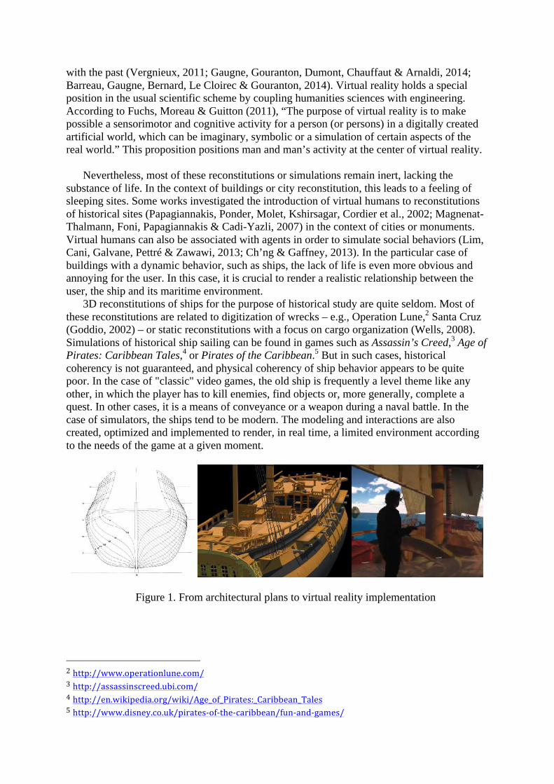
Figure 1. From architectural plans to virtual reality implementation
We propose a reconstitution in virtual reality of Le Boullongne, a ship of La Compagnie des Indes orientales. This reconstitution, presented in Figure 1, is based on the study of the ship led by a maritime history department, and a 3D modeling of the ship achieved by the West Digital Conservatory of Archaeological Heritage (Barreau, Gaugne, Bernard, Le Cloirec & Gouranton, 2013). The aim of the virtual reality implementation is to provide a realistic interactive naval simulation dedicated to research undertaken by historians. The 3D model of the ship has been integrated in an ocean simulation, with a physical rendering of the buoyancy. The simulation allows a user to walk around on the ship, at a scale of 1:1, and even steer it through a natural interaction. A video demonstration of the immersive virtual sailing on Le Boullongne can be seen on the web.6
2. Virtual reality and history
We believe that fields of virtual reality and history may enjoy mutual benefits triggered by
questions such as: 1. How can virtual reality, considered in its whole scope from science and technology
to human sciences and natural sciences, benefit the study of history? 2. What are the specific challenges brought by history to virtual reality? 2.1. Virtual reality for the study of history
Immersion, particularly in scale-one environments, allows archaeologists to evaluate symbolic or cultural roles of architectural buildings. Moreover, an historian can be placed in situations to validate specific activities, ranging from displacements within environments to more complex interactions by using haptic devices to evaluate the physical feasibility or the coherency of a task. This aspect strongly pertains to ergonomics and musculoskeletal activities, which are widely developed in the context of virtual reality. The historical reconstitution in virtual reality proposed in our work aims at providing a meaningful environment for historians, which corresponds to the following scientific problems:
• Is the representation of the historical universe credible for historians? Realism
and objective credibility are diametrically opposed issues. Objective credibility is an intrinsic quality of the reconstitution depending on the historian’s perception. Just as an X-ray picture has functional credibility for a medical practitioner, a virtual historian’s models and universes must be designed to ensure this credibility.
• Are historians able to evaluate hypotheses in the virtual reconstitution? Beyond the credibility of the reconstitution, the ability of an historian to acquire new knowledge is a key concern of our approach.
2.2. From history to virtual reality Conversely, heritage reconstitutions raise specific scientific challenges for the virtual
reality field of research. Scale-one immersion is a key characteristic proposed by virtual reality to historians, it is also a real issue in virtual reality while dealing with the concept of immersion (Fuchs et al. 2011) within an environment at human size. However, scale-one is not sufficient for historians who need to understand the functionalities of living spaces and social activities and interactions. Therefore, a virtual reality simulation
6 https://vimeo.com/ 130911371
dedicated to heritage must have the capacity to (i) set the historical universe in a functional condition, and (ii) put historians in situations to evaluate populations’ actions and interactions. These two issues combine consistency of the reconstitution and credibility of the simulation. This is particularly critical in the context of a ship where (i) the space and all its constituents are defined by their functionality, and (ii) all the sailors have a strong interaction with each other and are allocated to specific activities. 3. Historical context
In the history of trade globalization, the French East India Company, La Compagnie des Indes orientales, occupies a special place. It developed strategies and tools to enter the Asian market and prosper during the 17th and 18th centuries. To succeed in this enterprise, the company needed to control the shipping lanes, own ships, employ sailors, accumulate the experience of the sea and capitalize on knowledge. The French company was created in 1664, suspended in 1769, reorganized in 1784, and finally lost its monopoly in 1791 (Haudrère, 2005; Bowen, Mac Aleer & Blyth, 2011; Bruijn & Gaastra, 1993; Gardiner, 1995; Hackman, 2001; Jacobs, 2006).
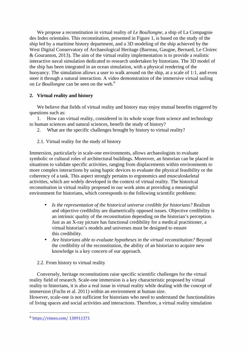
The port of l’Orient (Figure 2) was created for the company. The city was named after the
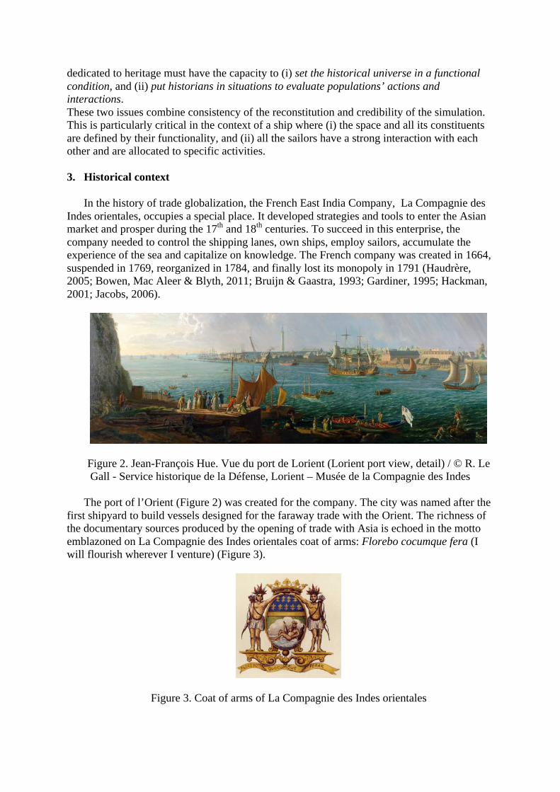
first shipyard to build vessels designed for the faraway trade with the Orient. The richness of the documentary sources produced by the opening of trade with Asia is echoed in the motto emblazoned on La Compagnie des Indes orientales coat of arms: Florebo cocumque fera (I will flourish wherever I venture) (Figure 3).
Figure 3. Coat of arms of La Compagnie des Indes orientales
The archives of La Compagnie des Indes orientales include a great variety of documents.
We can refer to the shipbuilding and breaking-up estimates, crew lists and muster rolls, masters’ certificates, officers and sailors’ “port-permis,”7 the registry numbers of seagoing personnel, and the ships’ laden inventories (Llinarès, 2009). This extensive documentary evidence can be used in the creation of multimedia teaching support materials and other, less serious, applications for the sharing of knowledge within archives services, museums, and tourism boards. The “journal de navigation” or logbook, a technical and discursive travel document, is an essential source for understanding the success of this great maritime trade and exchange between Europe and Asia, and the forms of interaction between various maritime and commercial cultures.
Le Boullongne was the result of the work of the royal builder G. Cambry. It was gauging
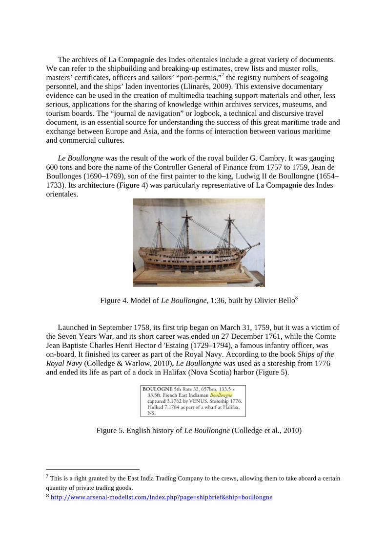
600 tons and bore the name of the Controller General of Finance from 1757 to 1759, Jean de Boullonges (1690–1769), son of the first painter to the king, Ludwig II de Boullongne (1654–1733). Its architecture (Figure 4) was particularly representative of La Compagnie des Indes orientales.
Figure 4. Model of Le Boullongne, 1:36, built by Olivier Bello8
Launched in September 1758, its first trip began on March 31, 1759, but it was a victim of
the Seven Years War, and its short career was ended on 27 December 1761, while the Comte Jean Baptiste Charles Henri Hector d 'Estaing (1729–1794), a famous infantry officer, was on-board. It finished its career as part of the Royal Navy. According to the book Ships of the Royal Navy (Colledge & Warlow, 2010), Le Boullongne was used as a storeship from 1776 and ended its life as part of a dock in Halifax (Nova Scotia) harbor (Figure 5).
Figure 5. English history of Le Boullongne (Colledge et al., 2010)
7 This is a right granted by the East India Trading Company to the crews, allowing them to take aboard a certain
quantity of private trading goods. 8 http://www.arsenal-‐modelist.com/index.php?page=shipbrief&ship=boullongne
4. Method 4.1. Historical analysis The ASIALOG project was developed at the University of South Brittany (France) by the
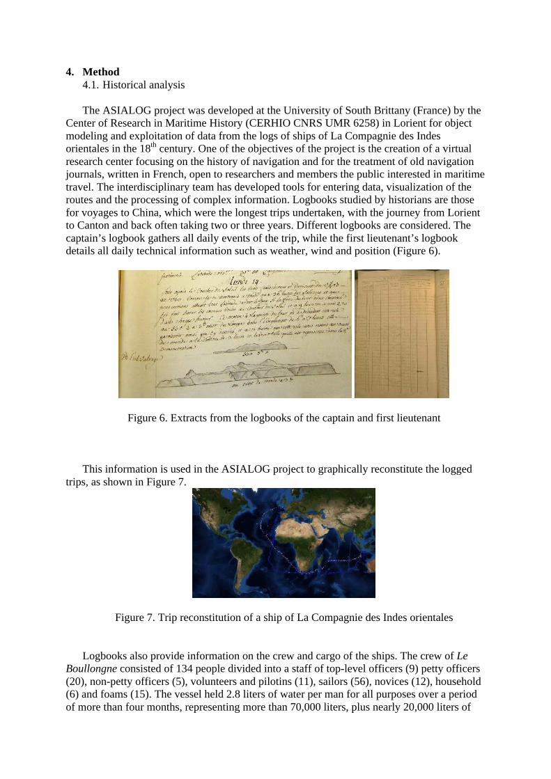
Center of Research in Maritime History (CERHIO CNRS UMR 6258) in Lorient for object modeling and exploitation of data from the logs of ships of La Compagnie des Indes orientales in the 18th century. One of the objectives of the project is the creation of a virtual research center focusing on the history of navigation and for the treatment of old navigation journals, written in French, open to researchers and members the public interested in maritime travel. The interdisciplinary team has developed tools for entering data, visualization of the routes and the processing of complex information. Logbooks studied by historians are those for voyages to China, which were the longest trips undertaken, with the journey from Lorient to Canton and back often taking two or three years. Different logbooks are considered. The captain’s logbook gathers all daily events of the trip, while the first lieutenant’s logbook details all daily technical information such as weather, wind and position (Figure 6).
Figure 6. Extracts from the logbooks of the captain and first lieutenant
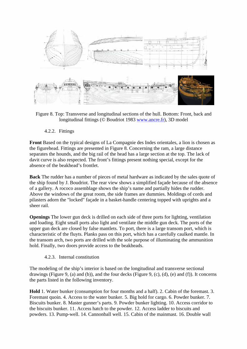
This information is used in the ASIALOG project to graphically reconstitute the logged
trips, as shown in Figure 7.
Figure 7. Trip reconstitution of a ship of La Compagnie des Indes orientales
Logbooks also provide information on the crew and cargo of the ships. The crew of Le
Boullongne consisted of 134 people divided into a staff of top-level officers (9) petty officers (20), non-petty officers (5), volunteers and pilotins (11), sailors (56), novices (12), household (6) and foams (15). The vessel held 2.8 liters of water per man for all purposes over a period of more than four months, representing more than 70,000 liters, plus nearly 20,000 liters of
wine, traditional biscuits for meals, and 64 tons firewood for the boiler due to the difficulty of sourcing it in the eastern regions. The numbers for food is equally impressive for the captain's table: 12,720 pounds of flour, 52 barrels of wine, 240 pints of wine, beer and liquor, 160 sheep, six goats, three oxen, two cows, 1565 chickens, 220 turkeys, 121 geese, 192 ducks, three sows, one boar, eight pigs, 1515 seasonings, 1200 items of groceries, 774 desserts and 248 vegetables. Goods constituting animal food completed this part of the cargo with hay, buckwheat, oats, barley, machemoure (fine dust of bread or biscuits resulting from successive manipulations), and straw, representing an investment of more than 1500 livres. Inventories also identify supplies such as silverware, glassware, china, pottery, pewter, brass, black and white shoes, casks, a long list of utensils, chests, soaps, candles, charcoal, lardoires, wood, etc.
4.2. 3D modeling
3D modeling of Le Boullongne was based on line plans drawn in a monograph (Boudriot, 1983). These 1:48 scaled plans were scanned and integrated in 3DsMax 2013. In the "Display Unit Scale" and "System Unit Setup" dialogs of 3DsMax, the scale of the unit was set to 1 meter and plans were then scaled to the correct dimensions. Modeling was thus done directly at 1:1 scale. Export to the FBX format in Unity preserved the dimensions. Like in other 1:1 reconstitutions we made previously, the check of dimensions compliance was made by measuring a reference item on the ground level at parallax 0 in our immersive platform. From these data, a graphic designer modeled the various objects that make up the ship and its rigging. Secondly, these elements were textured thanks to data gathered by the historian. Some textures, however, are still completely hypothetical. From bottom to top, the following inventory allows us to highlight the main parts of the 3D modeling process.
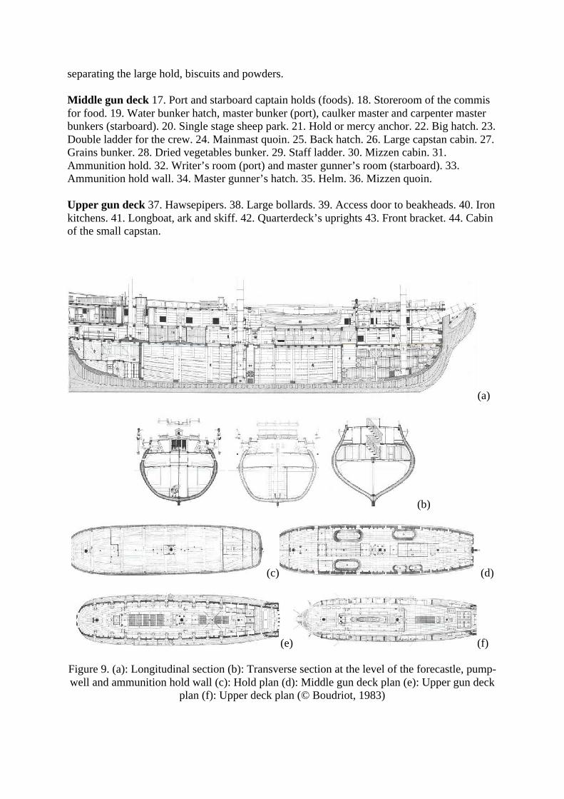
4.2.1. Hull The hull has an elongation coefficient of 4.2, which implies an elegant shape. The
stem measures 1/14 of the total length and thus has a low slenderness. The slope of the sternpost is 1/3 of the slenderness. Relative to the line of decks, the sheer is not very marked and the curvature of the ship’s side is 1/8 of the width. The ship has two pairs of wales, a large sheer rail at the gangways (slightly below forecastles) from stem to stern, two partial gunwale sheer rails (turned down) on the forecastle and the quarterdeck. A railing consisting of a few uprights and a sheer rail does not exceed the heights. The topsides are as low as possible because the gunwale sheer rails are almost at the deck planking. Figure 8 presents the hull plans.
Front Based on the typical designs of La Compagnie des Indes orientales, a lion is chosen as the figurehead. Fittings are presented in Figure 8. Concerning the ram, a large distance separates the hounds, and the big rail of the head has a large section at the top. The lack of davit curve is also respected. The front’s fittings present nothing special, except for the absence of the beakhead’s frontlet. Back The rudder has a number of pieces of metal hardware as indicated by the sales quote of the ship found by J. Boudriot. The rear view shows a simplified façade because of the absence of a gallery. A rococo assemblage shows the ship’s name and partially hides the rudder. Above the windows of the great room, the side frames are dummies. Moldings of cords and pilasters adorn the "locked" façade in a basket-handle centering topped with uprights and a sheer rail.
Openings The lower gun deck is drilled on each side of three ports for lighting, ventilation and loading. Eight small ports also light and ventilate the middle gun deck. The ports of the upper gun deck are closed by false mantlets. To port, there is a large transom port, which is characteristic of the fluyts. Planks pass on this port, which has a carefully caulked mantle. In the transom arch, two ports are drilled with the sole purpose of illuminating the ammunition hold. Finally, two doors provide access to the beakheads.
4.2.3. Internal constitution The modeling of the ship’s interior is based on the longitudinal and transverse sectional drawings (Figure 9, (a) and (b)), and the four decks (Figure 9, (c), (d), (e) and (f)). It concerns the parts listed in the following inventory. Hold 1. Water bunker (consumption for four months and a half). 2. Cabin of the foremast. 3. Foremast quoin. 4. Access to the water bunker. 5. Big hold for cargo. 6. Powder bunker. 7. Biscuits bunker. 8. Master gunner’s parts. 9. Powder bunker lighting. 10. Access corridor to the biscuits bunker. 11. Access hatch to the powder. 12. Access ladder to biscuits and powders. 13. Pump-well. 14. Cannonball well. 15. Cabin of the mainmast. 16. Double wall
separating the large hold, biscuits and powders. Middle gun deck 17. Port and starboard captain holds (foods). 18. Storeroom of the commis for food. 19. Water bunker hatch, master bunker (port), caulker master and carpenter master bunkers (starboard). 20. Single stage sheep park. 21. Hold or mercy anchor. 22. Big hatch. 23. Double ladder for the crew. 24. Mainmast quoin. 25. Back hatch. 26. Large capstan cabin. 27. Grains bunker. 28. Dried vegetables bunker. 29. Staff ladder. 30. Mizzen cabin. 31. Ammunition hold. 32. Writer’s room (port) and master gunner’s room (starboard). 33. Ammunition hold wall. 34. Master gunner’s hatch. 35. Helm. 36. Mizzen quoin. Upper gun deck 37. Hawsepipers. 38. Large bollards. 39. Access door to beakheads. 40. Iron kitchens. 41. Longboat, ark and skiff. 42. Quarterdeck’s uprights 43. Front bracket. 44. Cabin of the small capstan.
(a)
(b)
(c) (d)
(e) (f)
Figure 9. (a): Longitudinal section (b): Transverse section at the level of the forecastle, pump-well and ammunition hold wall (c): Hold plan (d): Middle gun deck plan (e): Upper gun deck
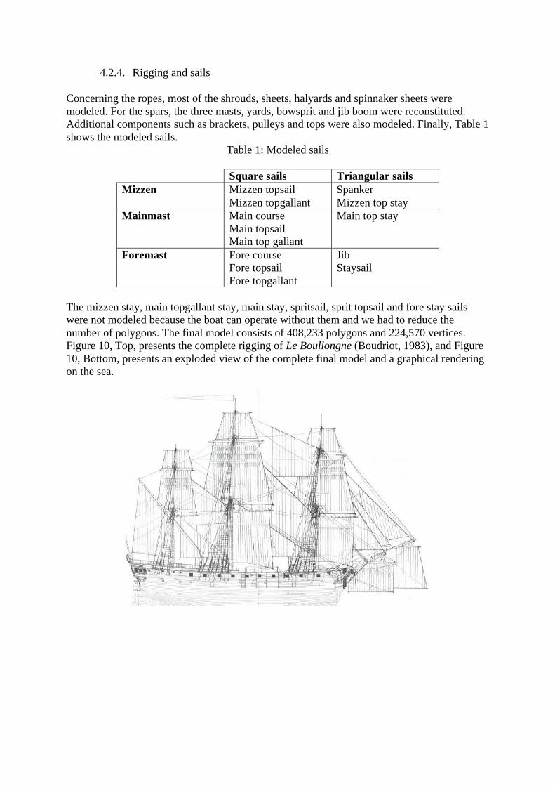
4.2.4. Rigging and sails Concerning the ropes, most of the shrouds, sheets, halyards and spinnaker sheets were modeled. For the spars, the three masts, yards, bowsprit and jib boom were reconstituted. Additional components such as brackets, pulleys and tops were also modeled. Finally, Table 1 shows the modeled sails.
Mainmast Main course Main topsail Main top gallant
Main top stay
Foremast Fore course Fore topsail Fore topgallant
Jib Staysail
The mizzen stay, main topgallant stay, main stay, spritsail, sprit topsail and fore stay sails were not modeled because the boat can operate without them and we had to reduce the number of polygons. The final model consists of 408,233 polygons and 224,570 vertices. Figure 10, Top, presents the complete rigging of Le Boullongne (Boudriot, 1983), and Figure 10, Bottom, presents an exploded view of the complete final model and a graphical rendering on the sea.
The main difference between the 3D modeling part and the virtual reality implementation
is the real-time rendering. This induces drastic constraints on computation to provide a fluid and convincing simulation. The complete 3D model of the ship was fully integrated in the virtual reality implementation without any simplification.
The interactive simulation was implemented with Unity 3D and MiddleVR. Unity 3D is a widespread cross-platform game creation system developed by Unity Technologies. It includes a game engine and an integrated development environment. MiddleVR is a generic immersive virtual reality plugin compatible with Unity. It handles interaction devices such as 3D trackers, stereoscopy, clustering with software and hardware scenelock and swaplock, and 3D interactions.
The virtual reality implementation of the sailing ship consists mainly of four points: • Visual environment: this part represents the first contact of the user with the
simulation. It gathers all visual elements, animated or not, that are presented in the simulation, in addition to the ship.
• Sound environment: sounds associated with visual elements or ambient sounds drastically enhance the immersive feeling of the user.
• Physical environment: this part mainly relates to sea simulation and buoyancy of the ship.
• Interactions: in virtual reality, human activity is at the center of the simulation. It allows the establishment of a natural relation between the user and the ship.
4.3.1. Visual environment
The visual environment of the ship comprises a geographical environment,
representing the sailing area, and animated elements either on-board or in the surrounding area. Another important aspect of the visual rendering is the light. The environment of the simulation is lightened by sunlight with dynamic shadows as the ship is always moving. A static lightmap was not possible in this context. The moving shadows following the movements of the ship reinforce the sense of realism. Geographical environment The geographical environment is a one square kilometer map,
with several little islands in the center. Figure 11 presents a global top view of the map, and a lateral view of the ground relief without the sea. The ship is displayed in the center of the map, close to the islands. The geographical environment designed in this simulation does not represent an existing location, as it was not the objective of the current work. Nevertheless, it should be interesting in further works to represent a real location coherent with a logged trip of Le Boullongne.
Figure 11. Top and lateral views of the map
Animated elements Three animated characters are present on the ship (Figure 12): the captain of the ship, close to the helm, one in the middle of the upper deck, at the port side, and one in the upper gun deck, at the starboard side. These characters have been provided by the company that designed the game Age of Pirates, and adapted to fit the Compagnie des Indes orientales costumes (Figure 13).
Figure 12. The three on-board characters. Courtesy of Akella and Playlogic Games.
Goupy (right) Musée de la Compagnie des Indes - Ville de Lorient
The captain reacts to the position of the user: when the user comes close to the helm, the captain walks backward on the deck to allow the user to interact with the helm. He comes back to the helm when the user moves away. The sailor on the upper deck is set to an idle position, looking at the sea, and the sailor on the upper gun deck is crouched, manipulating a gun.
In addition to the three on-board characters, two seagulls and a whale are moving in the
surrounding environment (Figure 14). The two seagulls fly in the air, performing close circles of 80 meters and 90 meters in diameter, respectively, around the ship, and the whale is swimming underwater, close to the surface, performing a fixed circle of 100 meters in diameter, at the south-west of the main island. The whale randomly changes its swimming speed and can also randomly dive.
Figure 14. Seagulls and whale characters
4.3.2. Sound environment There are several sound sources in the environment; some use binaural rendering with
the 3DCeption Unity plugin,9 while others use the default Unity 3D sound engine. Binaural sound was used in order to enhance the perception of the localization and distance of the sound sources; although, it induces additional computation, and the free version of the plugin imposes a limit on the number of sound sources. The two seagulls flying around the ship emit binaural random sounds amongst 11 sound files with a random time between each emission. Sounds for the whale use the same mechanism with five sound files.
We placed two long non-binaural sound sources, attached to the head node of the user, to emit ocean wave sound and wind sound. Due to its placement, both sounds will have a constant volume for the user with respect to the user’s position. The volume of the wind sound is changed with respect to the weather simulation. We also put a non-binaural sound
9 http://twobigears.com/
source that can emit wood-creaking sounds. This last source will randomly move around the ship and allow a random time after each creaking sound.
Finally, firing the cannons will emit a non-binaural explosion sound, and when the cannonball reaches the water, it will emit a water splash sound. Firing the cannons is triggered by the user, as described in section 4.3.4.
Except for the wave sound, all the source files described above are played with a small random pitch modification to reduce the feeling of repetition.
4.3.3. Physical environment
The physical environment is mainly related to the behavior of the ship with respect to the sea simulation, its buoyancy, and direction modification.
Ocean simulation The simulation of the sea is based on the Unity Community Ocean project10 scripts. Some modifications were made in order to allow the user to control the height and the sharpness of the waves, and the method of determining the water height at a given location has been modified. In the implemented simulation of the ocean, the height of waves can vary from 0 to 13 meters (Figure 15). The sea simulation comprises an algorithm deforming a plane with a specific sea material.
Figure 15. Maximum wave height
Physical behavior of the ship The position of the ship is calculated by applying various forces and effects. Buoyancy allows it to float on the ocean, a force and a torque are used for the navigation, and finally, gravity is pushing the ship downwards. Overall drag and angular drag are also set to simulate water resistance. The center of mass of the ship was manually specified to ensure that it is at the center of the ship, close the bottom of the hull. All the forces are applied to the root node of the ship, which guarantees that these forces move the whole ship as a single piece and no part of the ship is deformed.
All the forces applied to the ship are presented in Figure 16. The buoyancy force value (green vector) is null when the buoyancy point (pink square) is above the sea level, and becomes more and more important as the buoyancy point moves deeper below the sea level.
Figure 16. Physical forces applied to Le Boullongne
Buoyancy is created by placing several points on the hull of the ship that will apply an upper force at their position on the ship proportional to how deep below the water they are. In our application, we placed 10 points on the hull, all at the same height and distributed around the center of the ship as shown in Figure 17, where they appear as pink cubes, to ensure its stability. Ten points were necessary to obtain a realistic buoyancy effect. More points would of course enhance the quality of the effect but would require more computational power. The force applied on a point with global coordinates of x,y,z – with y being the up vector – is computed by the following expression:
buoyancyForce = forceRatio * Max (0, WaterLevel(x,y,z) − y) The value of forceRatio was empirically set to 2 in order to obtain the most realistic buoyancy effect. With high waves, a lower value causes the ship to go too deep under the waves, and a higher value makes it pitch and yaw too much.
Figure 17. Buoyancy points
Navigation consists of a constant force in the forward direction and a torque around the up axis proportional to the difference between the angle of the wheel and its initial angle. Several forces are applied to the ship and its speed varies with respect to the waves, much like a real ship. The speed on calm sea is 1.27 m/s, corresponding to 2.47 knots. The wheel is attached to the ship using a hinge. This hinge has min and max limits for the angle, a small bouncing effect and a spring. To simulate the helm mechanism, the angle of the wheel from its default position changes the torque value applied to the ship (See Figure 18). At each frame, the computation for the torque value is:
torque = Vector3.up*WheelAngle*Ratio
In our application, Ratio is set to 0.2, corresponding to a soft direction modification coherent with the inertia of the ship. The rotation of the wheel is controlled by the user as presented in section 3.3.4
Figure 18. Direction control with the wheel
Finally, invisible walls are placed on the map, represented in Figure 19 by green lines, to
prevent the ship from going too far. The angles between these walls will generally ensure that the ship will turn around while colliding with them. The green lines delimit the sailing area as a circle measuring 900 meters in diameter.
Figure 19. Navigation zone area
4.3.4. Interactions
Several interactions are proposed to the user in order to enhance his/her relation with the ship. The first interaction is the ability to move around on the ship. This interaction is complex in the context of a moving ship, because the user must keep his/her feet on the deck while walking around on it. The second interaction allows the user to steer the ship, with a natural hand interaction collocated with the wheel. The user can also fire the cannons. The last interaction is the control of the weather.
Moving around on the ship The user is placed on the ship by default. The node of the scene graph user_node representing the user is subjected to a gravity force pushing it downwards. To prevent this node from going through the ship, we placed colliders on every deck as well as on the rails and hull. In an immersive system, the user can naturally walk anywhere without colliding into anything, as we only apply physical forces to the origin of the tracking space, which is the user_node. The user’s head and hand are tracked and move scene nodes in
the application that are not physically constrained. The user_node can, however, be moved using any input such as a keyboard or a joystick to move the user across the ship (Figure 20). We also defined some key positions on the ship and on one of the islands where the user_node can be teleported. When the user is moved outside the ship, the user_node is placed at the root of the scene to decorrelate its movement from the ship movement. The user_node once again becomes a child of the ship node when the user is moved back onto the ship.
Figure 20. Exploring the ship
Steering the ship A collider is attached to the wheel as well as to the hand node that represents the user’s hand position in the virtual world. These colliders only serve as triggers, not as physical colliders. While the hand collider collides with the wheel collider, the angle between the hand node and the rotation axis of the wheel is stored and used to rotate the wheel angle during the next frame so that the wheel rotation follows the hand. When the hand collider leaves the wheel collider, the last angle continues to be applied but decreases over time to represent a friction effect on the wheel. The co-localization between the user’s hand and the hand collider provides a very natural interaction. Figure 21 illustrates the steering interaction.
Figure 21. Steering the ship
Firing the cannons The user can fire the cannons of the ship by selecting a cannon with a pointing device, as shown in Figure 22. The user then has to press a button to trigger the cannon. This will emit an explosion sound, smoke, fire and sparkling particles, and create a new cannonball object inside the cannon with a random initial force applied on the up axis and in the same direction as the cannon. When the cannonball reaches the water, it will emit some water splash particles associated with a water splash sound. The cannonballs are destroyed two seconds after hitting the water.
Figure 22. Firing the cannon
Controlling the weather The user can modify the wave height and sharpness as described in section 4.3.3. The movement of the ship is immediately impacted by the size and sharpness of the waves. When increasing the wave size, sunlight decreases and wind sound increases, inducing in the user a feeling of being in a storm. Figure 18 illustrates the storm ambiance.
4.4. Virtual reality environment
The application has been deployed on several immersive devices: the main one being the virtual reality platform called Immersia (Figure 23). This facility of the IRISA/Inria computer science laboratory is a large virtual reality room dedicated to real-time, multimodal (vision, sound, haptic, BCI) and immersive interaction. It hosts experiments using interactive and collaborative virtual reality applications that have multiple local or remote users.
Figure 23. Sailing on Le Boullongne, in Immersia
Images are rendered on four glass screens: a front one, two sides and a ground.
Dimensions are 9.6 m wide, 2.9 m deep and 3.1 m high. Over 20 million pixels are displayed. The visual reproduction system combines 13 computers and 13 HD projectors. A tracking system, composed of 16 infrared cameras, enables real objects to be tracked within the scene, such as the hand and the head of the user. Images are computed at a rate of 60 Hz and take into account the position of the head of the user. This system, with high-resolution rendering, active stereoscopy, tracking and homogeneous coloring, delivers a visually realistic and immersive experience. Spatial sound can be rendered by the speakers of the platform with 10.2 format or by a wireless stereo headset more suited to binaural rendering.
5. Results
The implementation of the virtual sailing of Le Boullongne was presented in Immersia to the whole ASIALOG team (Figure 24) with very favorable feedback. The historians noted
that the 1:1 reconstitution and the behavior of the ship on the sea constituted a really convincing simulation of sailing. Visiting the different decks of the ship raised many questions regarding the organization of on-board life and sparked several discussions between the historians due to the improved perception of volumes relating to the vessel.
Figure 24. ASIALOG team on-board
The virtual reality application has also been presented in different public exhibitions, such as Laval Virtual 2013, French National Days of Archaeology 2014, and Val’Ouest show 2014, representing several hundred visitors. In these exhibitions, the application was presented either on HMD, or a small CAVE-like structure, as illustrated in Figure 25.
Figure 25. Public exhibitions of the virtual Le Boullongne
Finally, the French national television channel France 3 also used the virtual reality
application in its series Thalassa to illustrate a documentary on La Compagnie des Indes orientales, as shown in Figure 26. The documentary was broadcast in May 2015.
Figure 26. Shooting of a documentary on La Compagnie des Indes orientales
6. Discussion
The virtual reconstitution of La Compagnie des Indes orientales ship was meant to provide the ASIALOG team with an additional tool for the understanding of sailing between Europe and Asia. Finally, the results have exceeded expectations; it is a new practice of validation of the historical sources in a new application environment, involving historians’ own physical activities and their perceptions. Being positioned on a ship in scale-one enables maritime historians to appreciate living and working conditions in a small space, overpopulated and in perpetual movement.
Immersia visits by historians of the ASIALOG team allowed us to evaluate the quality of the sailing ship simulation. Immediate feedback from historians addressed the credibility of the simulation, with a shared feeling of being on-board. Few ship plans of La Compagnie des Indes orientales have been preserved: there remain only a dozen. There exist no mock-ups or models dating from the 18th century in France for this type of ship. A model, even contemporary, rarely offers a vision of the interior of a ship. The historical reconstitution of Le Boullongne allows historians to understand the architecture of a merchant ship and especially to assess the dimensions and volumes of the different spaces, from the hold to the deck.
Historians try to figure out how life could be organized on the ship during trips that lasted between five and six months, with maximum congestion and strong promiscuity, as the ship carried between 130 and 150 persons. For example, the transition from forward to stern on the upper deck, or the height of the steerage where the guns are placed, seemed extremely narrow to historians. This raises the question of the actual use of guns, and the concrete movement of sailors and passengers on the upper deck. All these thoughts and discussions between historians were aroused following the natural 1:1 exploration of the ship. In particular, the necessity of walking in a crouching stance in the intermediate decks evoked in historians a study of historical archives of La Compagnie des Indes orientales which highlighted a particular pathology for sailors: most of them suffered a hernia. Carrying and storing goods in the confined cargo holds, with no possibility of standing up, may partly explain this pathology.
Simulating this movement in tandem with that of the ship allows the collection of viewing angles of the ship’s captain and highlights the stowage problems on the deck and in the hold. The view from the topgallant allows us to measure the height of the mast. Apart from being spectacular, this point of view brings about a feeling of danger. This puts into perspective the harshness of life on-board, with frequent accidents for the sailors working aloft in the rigging.
The animated crew demonstrates that without rigorous organization of life on-board, it is almost impossible to move without bumping into someone. As a result, the movement of men on-board was necessarily limited, just as it was for passengers. The presence of animals on-board the ship also raises the question of their place among the men and goods.
On the implementation side, the resulting application had to be convincing for a user in order to induce a feeling of being present on a ship, in terms of ambiance, and fluid enough to make the user forget the technology. On the Immersia platform, extremely demanding in terms of resources, the application runs at 20 fps and around 60 fps on lighter equipment such as HMDs. One can argue that the physical simulation is not scientifically accurate due to its many approximations and empirical choices. Two concerns led the implementation choices: the coherency of the physical behavior, and performances of the computations.
Three main difficulties were faced during implementation: hiding the sea surface inside the hull, coherently moving around on the ship with many intermediate levels, and synchronizing distributed animations in the Immersia configuration.
In order to mask the surface of the sea inside the ship, we used a shader associated with a set of invisible plans tailored to the shape of the hull. This shader allowed us to hide the material associated with the sea surface when it was behind the plan. This solution is not sufficient when the movement of the ship increases with the size of the waves, because the masking plan remains aligned with the deck and can move below the level of the sea when the ship is tilted. In this case, the sea can be visible inside the hull, thus entailing a break of user immersion. The solution is to disable the rendering of the sea when the user is inside the hull.
The ship has a complex structure within which to move around, with intermediate decks, scales, and shrouds. Unity provides the navmesh: a mechanism to handle the accessible area during navigation. This feature was not adapted to a moving space, as is required for a sailing ship. We thus based our on-board movement on physics, with colliders manually positioned in the ship to control the accessible area.
The software Unity is not designed to work in distributed clustering mode. We use the software MiddleVR to manage the synchronization of display. Unity animations are synchronized with Unity timestep, and are not natively synchronized by MiddleVR. We developed a synchronization barrier specific for animations, in order to synchronize the animations with MiddleVR timestep.
Conclusion and future works
We have presented a virtual reality implementation of the sailing of a 3D digital reconstitution of Le Boullongne, an 18th-century ship of La Compagnie des Indes orientales. The immersive and interactive application allows a user to sail on a 1:1 simulation of the sailing ship. The reconstitution was based on an historical work led by a maritime history research department, and a 3D modeling work achieved by the West Digital Conservatory of Archaeological Heritage.
Motivations for initiating similar projects are manifold. First, spending a significant amount of time to model a ship (or other archaeological complex entity), and elements that occupy it (objects, people, etc.), allows studies of the entity functioning in its environment. But from a methodological point of view, and in contrast to a number of current projects, we also think that static and visual reconstitutions should no longer be the finality. Beyond a summary of historians and archaeologists' knowledge, we believe that interactive immersion in these reconstitutions allows the emergence of observations, understandings and collaborative questions about physics, layouts, spatial dynamics and many other fields. Furthermore, the accumulation of this knowledge and these questions implies further research to discover how to save and test them in the virtual reconstitution. We think that generalizing these processes could lead to an enrichment of historians and archaeologists' methodologies.
Such simulation allows historians to sail on a disappeared ship. It enables a better understanding of how on-board life was organized, providing an immersive self-experience of the behavior of the ship. It also constitutes a powerful pedagogical tool, giving life to a valuable testimony of our history. The virtual sailing was presented to several public exhibitions.
Future works in the project will focus on the crew and the cargo of the ship. Using historical data, we started to experiment with the integration of 200 sailors, 150 chickens, five pigs, five sheep and three cows in the ship with adapted animated behaviors. We plan to integrate various human activities based on MoCap, and to study the opportunity to introduce agents to manage behaviors. We will also investigate the cargo on the ship at different steps of its commercial trip, corresponding to different freights.
Acknowledgments. The authors wish to thank Quentin Petit (CNRS) for his work on the implementation, Emilien Petit for his work on modeling, and Bruno Arnaldi (Insa de rennes) for his kind support. References Arnold, D. (2009). 3D-COFORM: Tools and Expertise for 3D Collection Formation,
Proceedings of EVA 2009 Florence Eds. V. Cappellini and J. Hemsley. Barreau, J.-B., Gaugne, R., Bernard, Y., Le Cloirec, G. & Gouranton (2013). V. The West
Digital Conservatory of Archaeological Heritage Project. In Digital Heritage International Congress, France, pp. 1–8.
Barreau, J.-B., Gaugne, R., Bernard, Y., Le Cloirec, G. & Gouranton, V. (2014). Virtual reality tools for the West Digital Conservatory of Archaeological Heritage. In Conference on Virtual Reality, France, pp. 1–4.
Barreau, J.-B., Bernard, Y., Petit, Q., Beuchet, L., Petit, E., Platen, V., Gaugne, R., Le Rumeur, J. & Gouranton, V. (2014). Combination of 3d scanning, modeling and analyzing methods around the castle of coatfrec reconstitution. In 5th International Euro-Mediterranean Conference (EuroMed 2014), Limassol, Cyprus.
Boudriot, J. (1983). Compagnie des Indes 1720-1770: Monographie. le Boullongne, vaisseau 600 tx., "Le Boullongne", 1759-1761, du constructeur G. Cambry. No. vol. 2 in Archéologie navale française, http://www.ancre.fr.
Bowen, H. V., Mac Aleer, J. & Blyth, R. J (2011). Monsoon trader: the maritime world of East India Compagny, Scala Publishers, London, 192 p.
Bruijn J. R. & Gaastra F. S. (1993). Ships, sailors and spices. East India Companies and their shipping in 16th, 17th and 18th Centuries, NEHA, Amsterdam, 208 p.
Ch’ng, E. & Gaffney, V.L. (2013). Simulation and Visualisation of Agent Survival and Settlement Behaviours in the Hunter-Gatherer Colonisation of Mesolithic Landscapes, in Ch’ng, E., Gaffney, V.L. and Chapman, H. (Eds.), Digital Heritage, Springer Cultural Computing Series.
Colledge, J. & Warlow, B. (2010). Ships of the Royal Navy. The complete record of all fighting ships of the Royal Navy from the 15th Century to the present, Casemate Publishers, LLC, 2010.
Fuchs, P., Moreau, G. & Guitton, P. (2011). Virtual Reality: Concepts and Technologies, July 2011, CRC Press.
Gardiner, R. (1995). The Heyday of sail. The Merchant Sailing Ship 1650-1830, Conway Maritime Press, London, p. 175.
Gaugne, R., Gouranton, V., Dumont, G., Chauffaut, A. & Arnaldi, B. (2014). Immersia, an open immersive infrastructure: doing archaeology in virtual reality. Archeologia e Calcolatori, supplemento 5, 1–10.
Goddio, F. (2002). Lost at Sea, The strange route of the Lena Shoal junk, Periplus Publishing Ltd, London.
Hackman, R. (2001). Ships of the East India Company. World Ship Society, Gravesend, 344p. Haudrère, P. (2005). La Compagnie française des Indes au XVIIIe siècle (The French India
Trading Company in the 18th Century). Les Indes savantes, 2e éd., Paris. Jacobs, E. M. (2006). Merchant in Asia. The Trade of the Dutch East India Company during
the Eighteenth Century, CNWS Publications, Leiden, p. 471. Lim, C. K., Cani, M.-P., Galvane, Q., Pettré, J. & Zawawi, T. A. (2013). Simulation of Past
Life: Controlling Agent Behaviors from the Interactions between Ethnic Groups. Digital Heritage International Congress.
Llinarès S. (2009). The forms of interaction between France and South Asia as mirrored in the
archives of the 17th and 18th centuries. Histories from the Sea : Multimedia for Understanding and Teaching Europe-South Asia Maritime Heritage, Edited by Jawaharlal Nehru University, New Delhi, p. 9-16.
Papagiannakis, G., Ponder, M., Molet, T., Kshirsagar, S., Cordier, F., Magnenat-Thalmann, N. & Thalmann, D. (2002). LIFEPLUS: Revival of life in ancient Pompeii. Virtual Systems and Multimedia (VSMM02), Gyeongju.
Magnenat-Thalmann, N., Foni A.E., Papagiannakis, G & Cadi-yazli, N (2007) Real Time Animation and Illumination in Ancient Roman Sites. International Journal of Virtual Reality - IJVR, vol. 6, no. 1, pp. 11-24.
Vergnieux, R. (2011), Archaeological research and 3D models (Restitution, validation and simulation), Virtual Archeology Review, Vol. 2, Num. 4, p. 39-43.
Wells, A. E. (2008) Virtual Reconstruction of a Seventeenth Century Portuguese Nau, Master's Thesis, Texas & M University, Visualization Sciences, 2008.