AN IMMOVABLE HISTORICAL ASSET INFORMATION SYSTEM DESIGN AND APPLICATION: A CASE STUDY OF TRABZON S. Reis, R. Nisanci, V. Yildirim, H. I. Inan, T. Yomralioglu * KTU, Geodesy and Photogrammetry Engineering Department, 61080 Trabzon, Turkey (sreis, rnisanci, yvolkan, hibrahim, tahsin)@ktu.edu.tr Commission VI, WG II KEY WORDS: GIS, Databases, Cultural Heritage ABSTRACT: Protecting, advertising and transferring to the next generations of historical assets is one of the most important mission of societies. The protection of an heritage is not left only self-respect of individuals but also guaranteed under law. However, arrangement, protection and regulation of inventories about historical assets, using classical techniques, is an extremely hard process in a country having a vast many historical assets like Turkey. Considered their locations and characteristics, historical assets have different features. In classical systems, locations (address) and attributes (memorial buildings, examples of civilian architecture, the number of storeys, owner, protection degree, etc.) of historical places are kept in paper passed environments. Separations between historical assets in the maps are enabled using different colours (representing objects according to classes and kinds) and symbols. A historical place on which an investigation required is informed about by searching through all archive files. In addition to causing loss of time and labour, this method makes difficult to save these assets thoroughly. On the other hand, in the information era, the value and importance of information have been accepted among all communities. People who use information have been studying on possibilities of reaching information faster and more easily. Used among different professions in recent years, Geographical Information System (GIS) provides a considerable comfort for users in recording inventories about historical assets because GIS have a great deal of facilities such as storing graphical and non-graphical data at the same time, linking and analyzing with each other, offering information at any scale. In this study, inventory of historical assets in Trabzon city has been computerized, and a database design of historical assets has been realized. So, a historical asset information system (HAIS) has been formed. HAIS involves photographs, videos, graphical and non-graphical information about historical assets. * Corresponding author : [email protected]1. INTRODUCTION Cultural assets in a country are not only a part of that country but also a part of worldwide cultural assets. So, current cultural assets should be presented in an easily-accessible environment. Today’s improved communication technologies have an crucial role in collecting, presenting and sharing data. Affects of Geographical Information Systems (GIS) on spatial query and analysis works make extremely easy to present cultural assets. In this regard, after collecting Immovable Historical Asset (IHA) spatial and non-spatial information, it is important to manage this data under a database (Duran, 2002). Increasing the quantity and quality of information about the cultural heritage will help in making more effective decisions regarding the organization of modern life in the historical cities and confront them to the challenge of globalization against rising decline. There are numerous general texts, books and research about monuments, but very little raw data suitable for geographical analysis (Esposito, 2003). The extreme main problem encountered in GIS studies is the lack of required quality data (Siebert, 2000). Spatial data that is of adequate quality and quantity is the most indispensable component of planned database concerning historical assets. This kind of data should be acquired in an appropriate form in data collecting stage and it should be manipulated in carefully designed databases in the stage of data storing (Reis, 2002). Designation stages of databases especially planned for large areas – nationwide or covering a region should be implemented in a planned way because of intense data. In Turkey, the key problem of Immovable Cultural Heritage (ICH)’s site management is that the sites are not systematically located on an official map or collected into a database. Because nongraphical information about immovable historical assets in Turkey are held currently in classical archive systems, it has been encountered some problems in labeling, controlling and performing spatial query about these assets. In order to form a database concerning immovable historical assets, it is needed to gather inventory records and spatial features in a standardized way and to link them one another. While nongraphical data includes city name, district name, photo, address, constructional situation and conservation condition, graphical data is formed by property maps(1/500, 1/1.000, 1/2.000 scaled cadastral maps), land development plan and current base map (1/1.000 scaled base maps). Immovable historical assets in Turkey are under responsibility of the Ministry of Culture and Tourism. Under responsibility of this ministry, General Directorate of Cultural and Natural Conservation and Directorate of Cultural and Natural Conservation, under responsibility of this general directorate and organized in regional base, work on determination and conservation of nationwide cultural and natural assets. In order to implement zone-based works quickly and precisely, forming directorate-based databases is strongly needed.
Transcript
AN IMMOVABLE HISTORICAL ASSET INFORMATION SYSTEM DESIGN AND APPLICATION: A CASE STUDY OF TRABZON
S. Reis, R. Nisanci, V. Yildirim, H. I. Inan, T. Yomralioglu * KTU, Geodesy and Photogrammetry Engineering Department, 61080 Trabzon, Turkey
KEY WORDS: GIS, Databases, Cultural Heritage ABSTRACT: Protecting, advertising and transferring to the next generations of historical assets is one of the most important mission of societies. The protection of an heritage is not left only self-respect of individuals but also guaranteed under law. However, arrangement, protection and regulation of inventories about historical assets, using classical techniques, is an extremely hard process in a country having a vast many historical assets like Turkey. Considered their locations and characteristics, historical assets have different features. In classical systems, locations (address) and attributes (memorial buildings, examples of civilian architecture, the number of storeys, owner, protection degree, etc.) of historical places are kept in paper passed environments. Separations between historical assets in the maps are enabled using different colours (representing objects according to classes and kinds) and symbols. A historical place on which an investigation required is informed about by searching through all archive files. In addition to causing loss of time and labour, this method makes difficult to save these assets thoroughly. On the other hand, in the information era, the value and importance of information have been accepted among all communities. People who use information have been studying on possibilities of reaching information faster and more easily. Used among different professions in recent years, Geographical Information System (GIS) provides a considerable comfort for users in recording inventories about historical assets because GIS have a great deal of facilities such as storing graphical and non-graphical data at the same time, linking and analyzing with each other, offering information at any scale. In this study, inventory of historical assets in Trabzon city has been computerized, and a database design of historical assets has been realized. So, a historical asset information system (HAIS) has been formed. HAIS involves photographs, videos, graphical and non-graphical information about historical assets.
Cultural assets in a country are not only a part of that country but also a part of worldwide cultural assets. So, current cultural assets should be presented in an easily-accessible environment. Today’s improved communication technologies have an crucial role in collecting, presenting and sharing data. Affects of Geographical Information Systems (GIS) on spatial query and analysis works make extremely easy to present cultural assets. In this regard, after collecting Immovable Historical Asset (IHA) spatial and non-spatial information, it is important to manage this data under a database (Duran, 2002). Increasing the quantity and quality of information about the cultural heritage will help in making more effective decisions regarding the organization of modern life in the historical cities and confront them to the challenge of globalization against rising decline. There are numerous general texts, books and research about monuments, but very little raw data suitable for geographical analysis (Esposito, 2003). The extreme main problem encountered in GIS studies is the lack of required quality data (Siebert, 2000). Spatial data that is of adequate quality and quantity is the most indispensable component of planned database concerning historical assets. This kind of data should be acquired in an appropriate form in data collecting stage and it should be manipulated in carefully designed databases in the stage of data storing (Reis, 2002). Designation stages of databases especially planned for large areas –
nationwide or covering a region should be implemented in a planned way because of intense data. In Turkey, the key problem of Immovable Cultural Heritage (ICH)’s site management is that the sites are not systematically located on an official map or collected into a database. Because nongraphical information about immovable historical assets in Turkey are held currently in classical archive systems, it has been encountered some problems in labeling, controlling and performing spatial query about these assets. In order to form a database concerning immovable historical assets, it is needed to gather inventory records and spatial features in a standardized way and to link them one another. While nongraphical data includes city name, district name, photo, address, constructional situation and conservation condition, graphical data is formed by property maps(1/500, 1/1.000, 1/2.000 scaled cadastral maps), land development plan and current base map (1/1.000 scaled base maps). Immovable historical assets in Turkey are under responsibility of the Ministry of Culture and Tourism. Under responsibility of this ministry, General Directorate of Cultural and Natural Conservation and Directorate of Cultural and Natural Conservation, under responsibility of this general directorate and organized in regional base, work on determination and conservation of nationwide cultural and natural assets. In order to implement zone-based works quickly and precisely, forming directorate-based databases is strongly needed.
2. IMMOVABLE HISTORICAL ASSETS AND GEOGRAPHICAL INFORMATION SYSTEM
Immovable historical assets are monuments and conservation areas. These represent immovable prehistorical or hictorical assets on the ground, under the ground or on the sea bed, relating to science, culture, religion and fine arts (Aydemir, 1999). IHA’s in Turkey are classified as immovable cultural assets, immovable natural assets, urban, historical and natural conservation areas (TC Resmi Gazete, 1989). Recoded conservation areas in Turkey are presented in Table 1. As seen in the Table 1, 6.812 units of conservation areas and 71.775 units of cultural and natural assets have been determined and registered. In the responsibility area of Trabzon Conservation of Cultural and Natural Assets Committee, there are registered 1.158 units of cultural and natural assets or conservation areas. These figures about historical assets reflect prosperous characteristic of Turkey as regards its cultural and natural assets.
Turkey
Trabzon Cultural and
Natural Conservation Committee
Conservation Areas
Count Archaeological Cons. Area 5.278 2Natural cons areas 831 11Urban cons areas 188 8Historical cons areas 125 2Other cons areas 390 3Cultural (Single building base) and natural entity
64.963 1.132
Total 71.775 1.158
Table 1. Number of registered conservation areas and buildings in Trabzon and Turkey, (Kültür Bakanlığı, 2003)
IHA inventory records in Turkey are performed using information documents prepared in accordance with some standards and techniques concerning “Conservation Inventory of Natural and Cultural Assets” prepared by European Council. These info-documents include;
Inventory Number: Determines the place of building or area in need of conservation. For example; in inventory number of 61.00-1.3-303 (61: city, 00: district, 1.3: tipologic number, 303: monument name). Tipologic Number : Numbers representing monuments. Map Number : Number of property or development map. General Information: City, district, street, address number, property map number.
When the importance of spatial information of objects are considered, the main problem concerning immovable historical assets is that these assets are not registered using a special map or database recording system. That there is no link among TTE, cadastral maps, development map and current base map makes difficult preparation and implementation of some engineering projects (e.g, expropriation, road project, development map applications). Historical Asset Information System (HAIS) is a spatial information system by which graphical and non-graphical data about immovable historical assets are linked, analyzed and
queried as regards their spatial locations. This system will guarantee implementation of some processes rapidly and in a reliable way beginning determination of historical assets by authorized committees through registration of these into the cadastral records. In the currently used system, spatial data acquired in determination stage is held on paper materials in ordinary archives. In this classical filing system, there is no proper availability to query and analyze acquired data. For instance, representing TTE data acquired in a specific year or having specific features on a map is not possible. In addition, because some required base-maps such as cadastral maps, development plans, and current topographical maps are under responsibility of different foundations, it is not easily possible to use this data in digital form. GIS is a system that allows to make a link with the earth by making possible spatial data organization, monitoring and analyzing (Yomralıoğlu, 2000). So, in order to monitor historical assets by combining these with geographical structure, GIS should be used. GIS have some advantages and disadvantages in determination and conservation of historical assets. These are as fallows: One of the advantages of GIS is that it provides rapid access to quality data and a possibility to share internal or external data between foundations. One of the main comforts of GIS as regards IHA researches is that it makes possible analyzing and querying high quality data. For example, similar historical data gathered in different dates by different institutions can be easily determined and studied. Another advantage of GIS is that metadata called as data about data can be stored as regards different data types or coverages. Thus, making easier to access to information in time by researchers or foundations. The most important disadvantage in accessing classical IHA storage systems is that it causes a loss of time and labor force. Meanwhile, it can be provided to access easily to data stored in a GIS system by using a graphic user interface. The most important disadvantage of GIS is that storing intense spatial data especially covering large areas in a database in specified standards is an expensive and time-consuming process.
2.1 IHA Database Design
Available data required for formation of new IHA database is on paper-based forms, of poor quality, not up to date, lack of adequate details and in different coordinate systems. Using or manipulating cadastral maps, land development plans and current topographic maps which is analog is a difficult process to execute. In addition to this, there are several regions not having even this kind of data. Besides, in these systems, visual materials such as photos, videos or graphical maps are either inadequate or not easily accessible. Because of swift expansion of urban areas in Turkey, it has become an indispensable need to develop techniques for conservation and presentation of historical assets. By integrating conservation areas, cultural and natural assets, cadastral maps, topographic maps and land development plans, IHA information system should be established. Providing a proper administrative organization on IHA is not only possible
with software or hardware technology but also with properly organized data (URL-1, 2003).
Prior to establishing a IHA database, it is necessary to perform a feasibility analysis. After determining differences between new IHA and classical system, the advantages of IHA database should also be determined. As regards graphical data in the system currently in use: firstly movable or immovable assets related with IHA project are determined. It is determined that these assets can be regarded as historical asset or not. For the assets considered to be historical, provisions stated in the regulation are provided. Second stage is registration process. Realizing registration process is based on performing property registrations in the region in question. However, cadastral survey has not been completed yet, especially in outside the residential areas.
2.2
2.3
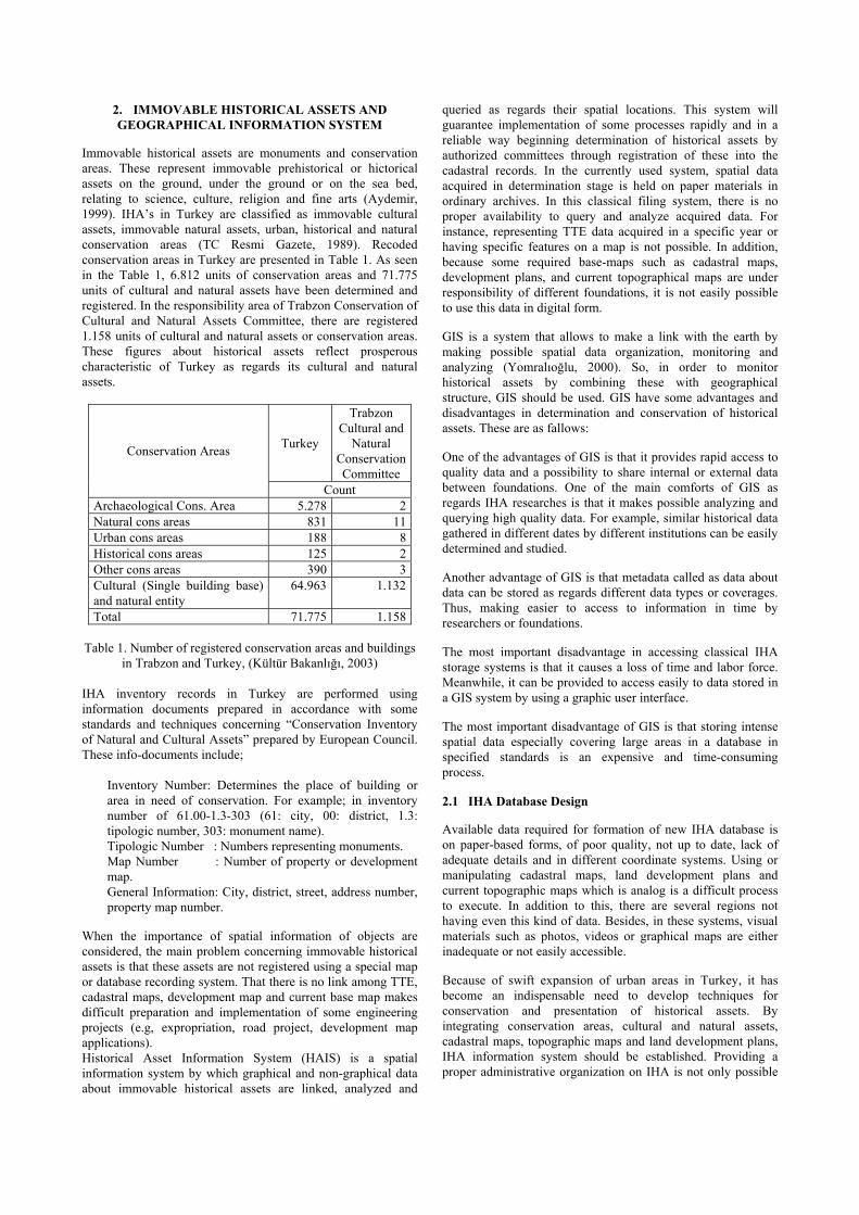
General Structure of HAIS
Databases that belong to IHAs will be regulated respect to province based. Directorships of the Cultural and Natural Conservation Committees will constitute province databases under their responsibility. Designed respect to Directorships of the Cultural and Natural Conservation Committees, TTE Information Systems are seen in Figure 1. The system is divided into two main categories. These are graphical and non-graphical data. Graphical data is divided into two parts as interior and exterior layer. Exterior layers are cadastral maps, current base maps, land development plans, aerial photographs, remotely sensed images and standardized topographic maps. Because, cadastral maps and land development plans are changeable and they are used in registration and conservation processes, cadastre and municipality intuitions and Directorships of Cultural and Natural Conservation Committees, updating these data, should communicate online. The other data can be acquired in specific time periods. More detailed construction on exterior layers can also be realized. Especially, among Directorships of Cultural and Natural Conservation Committees, cadastre, municipality and governorship, a structure could be developed to data exchange.
Figure 1. General structure of an IHA information system
Interior graphic data are conservation areas, cultural and natural entities and re-survey documents. Positions of conservation areas and cultural and natural entities are specified via exterior
layers explained above. IHAs are positioned on a map in the scale of 1/1000 where cadastral and current topographical maps exist. If cadastral and current maps are on paper, these are firstly digitized via digitizing process. Determination and registration of IHA in such areas are easy. However, determining and positioning on maps of IHA are very difficult and positional accuracy is not enough in classical ways in places where cadastral and current maps are non-exist. In such areas, the location of IHA is positioned manually on a Standard Topographical Map (STM) scaled as 1/25000. On the STM on which conservation areas are positioned, querying and analyzing of cadastral parcels could not be needed position accuracy. In this areas where producing of their current maps could not be possible in short time, it should be used different data acquisition methods. Firstly, aerial photos or remotely sensed data in high resolution should be used. If that is also not possible, position data of TTE should be acquired with GPS. Re-surveys should be transferred to digital environment via softwares enabling three dimensional map producing. In a database designed respect to province, directorship and nationwide, combination of data under the same coordinate system is important. While STM is produced in 60 UTM coordinate system, other used maps are produced in 30 UTM coordinate system. In a region or nationwide database, spatial data should be constituted in base maps having same coordinate system. For this reason, 30 UTM coordinate system for province base, 60 UTM coordinate system for region base and geographic coordinate system for all country or Lambert Conform Conic projection should be preferred. The second part of IHA information system constitutes non-graphical information which are inventory records, photo-video image, legal procedures, archives information, specialist reports and title records. While some of these information is related with graphical information, the others are independent from them. Non-graphical information is stored in MS Access Database using an interface prepared in Visual Basic environment. Management of non-graphical information in this database will be supplied with four modules. These are; data entry, data manipulating, data querying-analyzing and reporting.
HAIS GRAPHICAL INTERFACE IHA Information System will be managed from Information
Process Center constituted in Directorships of Cultural and Natural Conservation Committees. Database was designed respect to province based to access more rapidly to IHA information and to provide control. Combining of provinces will constitute directorships. By combining of directorships, nationwide IHA Information System will be constituted in general directorships. After acquiring nationwide data, it will be presented to users on-line, in General Directorship of Cultural and Natural Conservation Committee
Regulations Reports
Inventory records
LAYER STRUCTURE OF IMMOVABLE HISTORICAL ASSET INFORMATION SYSTEM
Internal Layers - immovable cultural assets - conservation areas - re-survey – restitusyon – restoration projectExternal Layers - property - current base - land development plan - aerial photo, remotely sensed image
3. TRABZON CITY IHA INFORMATION SYSTEM
Trabzon is a city on the Black Sea Cost in the northeast of Turkey with the population of 150 thousands, and a history which goes back to the 800 B.C (Trabzon Valiliği, 2002). Trabzon city IHA information system is composed of two categories. One of them is inner Trabzon City; the other is the outer city. While 1/1000 scaled base maps are used in the inner city, the outer city are mapped only on 1/25.000 – 1/100.000
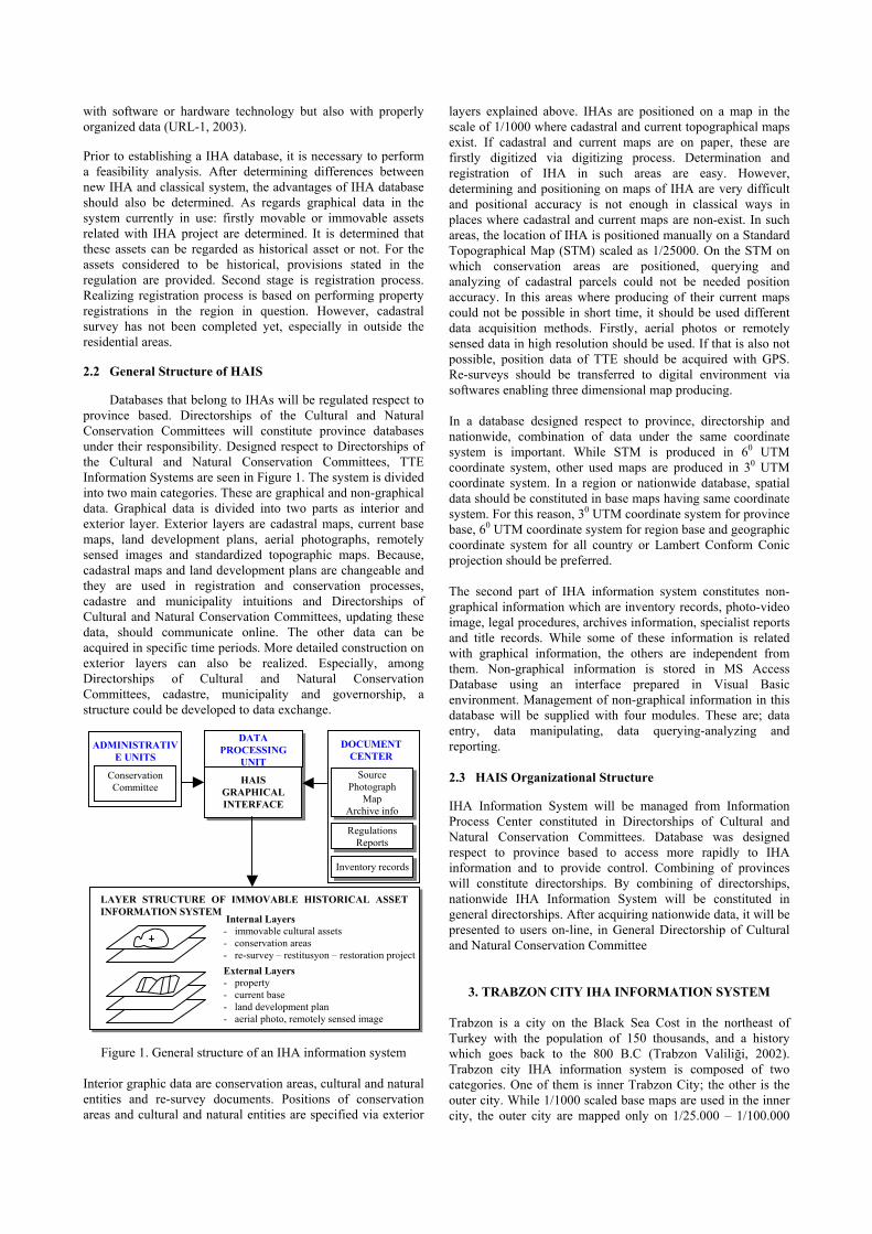
scales. Graphic data in and outside the city is combined under 30 UTM projection. An interface was developed for constitution of cultural and natural entities protection inventory table respect to TTE in digital environment. This interface was developed in Visual Basic environment and MapObjects software is used to display graphical processes (Figure 2). Data entered via this interface is stored in MS Access Database. Allowing querying of cultural and natural existence and conservation areas in name and sheet based, the interface also can be used for print out of document as in inventory record table. Cadastral map, development plan and current base map of the city were constituted in digital format and integrated with the
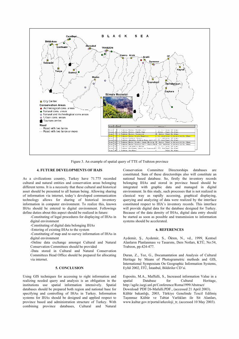
interface. Providing linkage of cultural and natural entities and conservation areas entered in database with development plan, cadastral map and current base map, control processes could be directly realized in Data Processing Unit without any need for land studies of IHA (Figure 1). If cultural and natural entities and conservation areas outer the city center are in 1/1000 scaled map, they were digitized, if not, their positions were acquired via hand-GPS and then these data was combined with digital environment. As an example, graphical and non-graphical information of IHA of Trabzon province were displayed in Figure 3.
Figure 2. Screen display of the interface of IHA inventory table
Figure 3. An example of spatial query of TTE of Trabzon province
4. FUTURE DEVELOPMENTS OF HAIS As a civilizations country, Turkey have 71.775 recorded cultural and natural entities and conservation areas belonging different terms. It is a necessity that these cultural and historical asset should be presented to all human being. Allowing sharing of information via internet, today’s developed communication technology allows for sharing of historical inventory information in computer environment. To realize this, known IHAs should be entered to digital environment. Followings define duties about this aspect should be realized in future:
-Constituting of legal procedures for displaying of IHAs in digital environment -Constituting of digital data belonging IHAs -Entering of existing IHAs to the system -Constituting of map and re-survey information of IHAs in digital environment -Online data exchange amongst Cultural and Natural Conservation Committees should be provided -Data stored in Cultural and Natural Conservation Committees Head Office should be prepared for allocating via internet.
5. CONCLUSION
Using GIS techniques for accessing to right information and realizing needed query and analysis is an obligation in the institutions use spatial information intensively. Spatial databases should be prepared both region and national base for specifying and controlling of IHAs in Turkey. Information systems for IHAs should be designed and applied respect to province based and administration structure of Turkey. With combining province databases, Cultural and Natural
Conservation Committee Directorships databases are constituted. Sum of these directorships also will constitute an national based database. So, firstly the inventory records belonging IHAs and stored in province based should be integrated with graphic data and managed in digital environment. In this study, such processes that is not realized in classical way as rapidly accessing, graphical displaying, querying and analyzing of data were realized by the interface constituted respect to IHA’s inventory records. This interface will provide digital data for the database designed for Turkey. Because of the data density of IHAs, digital data entry should be started as soon as possible and transmission to information systems should be accelerated.
6. REFERENCES
Aydemir, Ş., Aydemir, S., Ökten, N., vd., 1999, Kentsel Alanların Planlanması ve Tasarımı, Ders Notları, KTÜ, No:54, Trabzon, pp.424-477. Duran, Z., Toz, G., Documantation and Analysis of Cultural Heritage by Means of Photogrametric methods and GIS, International Symposium On Geographic Information Systems, Eylül 2002, İTÜ, İstanbul, Bildiriler CD’si. Esposito, M.A., Maffulli, S., Increased information Value in a spatial Database for Cultural Heritage, http://agile.isegi.unl.pt/Conference/Roma1999/Abstract/ Download/ PDF/26-Mafulli.PDF., (accessed 21 April 2003). Kültür bakanlığı, 2003, Türkiye Genelinde Tescil Edilmiş Taşınmaz Kültür ve Tabiat Varlıkları ile Sit Alanları, www.kultur.gov.tr/portal/arkeoloji_tr, (accessed 10 May 2003).
Naglič, K.K., Cultural Heritage Information System in The Republic of Slovenia, http://www.arcchip.cz/w05/w05_naglic.pdf, (accessed 12 February 2003). Reis, S., İnan, H.İ., Yomralıoğlu, T., Desinging A Regional Geographic Database and Its Application, International Symposium On Geographic Information Systems, Eylül 2002, İTÜ, İstanbul, Bildiriler CD’si. Siebert, L., 2000, Using GIS to Document, Visualize, and Interpret Tokyo’s Spatial History, Social Science History, 24.3, pp.537-574.
TC Resmi Gazete, 1989, Korunması Gerekli Taşınmaz Kültür ve tabiat Varlıklarının Tespit ve Tescili hakkında Yönetmelik, Sayı:20257 Trabzon Valiliği, 2002, Trabzon, CemOfset, Trabzon, 2002 URL-1, EAIS Project, http://www.eais.org.eg/ main/ project_summary.asp, (accessed 25 May 2003). Yomralıoğlu, T., Coğrafi Bilgi Sistemleri Temel Kavramlar ve Uygulamalar, 2. baskı, İber ofset, İstanbul, 2002