Page 1
An Interface System to Couple
the SWAT2005 Model with
HyGIS(HyGIS-SWAT)
Yun Seok Choi*
Kyung Tak Kim
Joo Hun Kim
Water Resources Research Division,
Korea Institute of Construction Technology
2010.08.05
Page 2
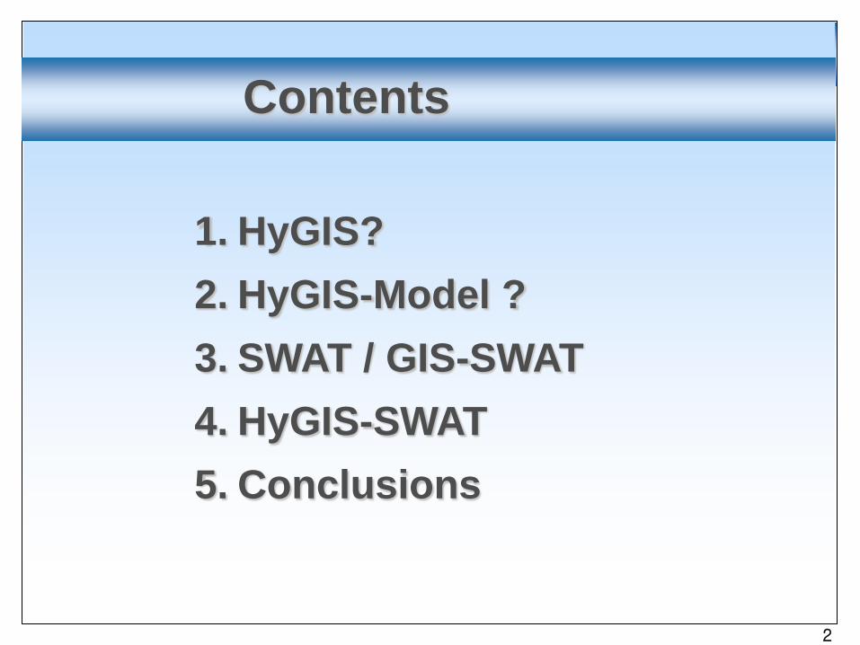
1. HyGIS?2. HyGIS-Model ?3. SWAT / GIS-SWAT 4. HyGIS-SWAT5. Conclusions
Contents
2
Page 3
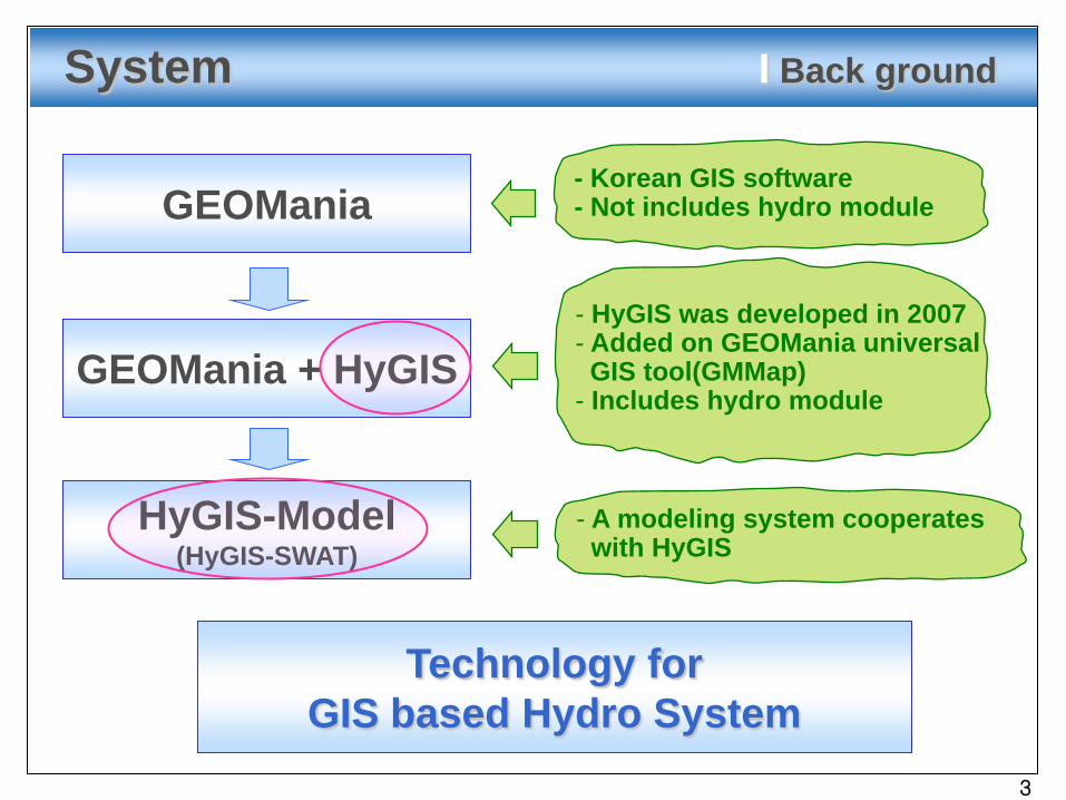
- Korean GIS software- Not includes hydro moduleGEOMania
HyGIS-Model(HyGIS-SWAT)
GEOMania + HyGIS
System I Back ground
- HyGIS was developed in 2007- Added on GEOMania universalGIS tool(GMMap)
- Includes hydro module
- A modeling system cooperates with HyGIS
Technology forGIS based Hydro System
3
Page 4
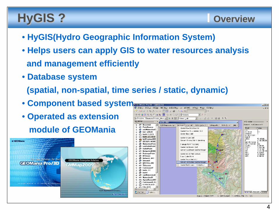
HyGIS ? I Overview
• HyGIS(Hydro Geographic Information System)• Helps users can apply GIS to water resources analysisand management efficiently
• Database system(spatial, non-spatial, time series / static, dynamic)
• Component based system• Operated as extension
module of GEOMania
4
Page 5
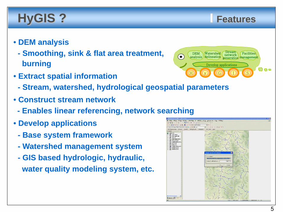
HyGIS ? I Features
yH G I S
Develop applications
DEManalysis
Watersheddelineation
Streamnetwork
generation
Facilitiesmanagement
• DEM analysis- Smoothing, sink & flat area treatment,burning
• Extract spatial information- Stream, watershed, hydrological geospatial parameters
• Construct stream network- Enables linear referencing, network searching
• Develop applications- Base system framework- Watershed management system- GIS based hydrologic, hydraulic,water quality modeling system, etc.
5
Page 6
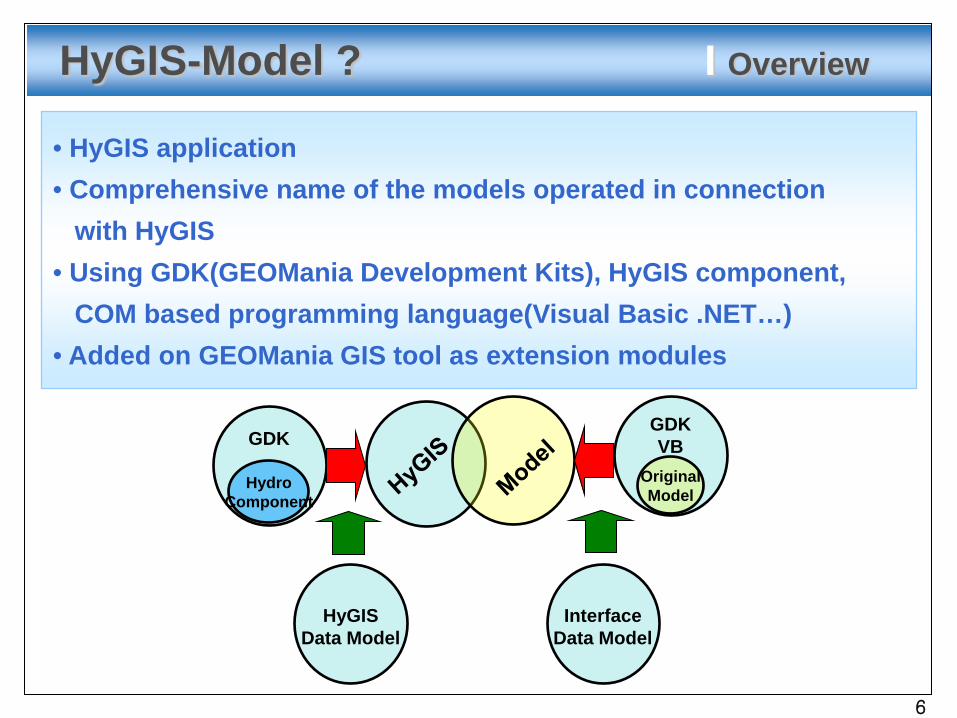
• HyGIS application• Comprehensive name of the models operated in connection
with HyGIS• Using GDK(GEOMania Development Kits), HyGIS component,
COM based programming language(Visual Basic .NET…)• Added on GEOMania GIS tool as extension modules
GDKGDKVB
HydroComponent
OriginalModel
HyGISData Model
InterfaceData Model
HyGIS-Model ? I Overview
6
Page 7
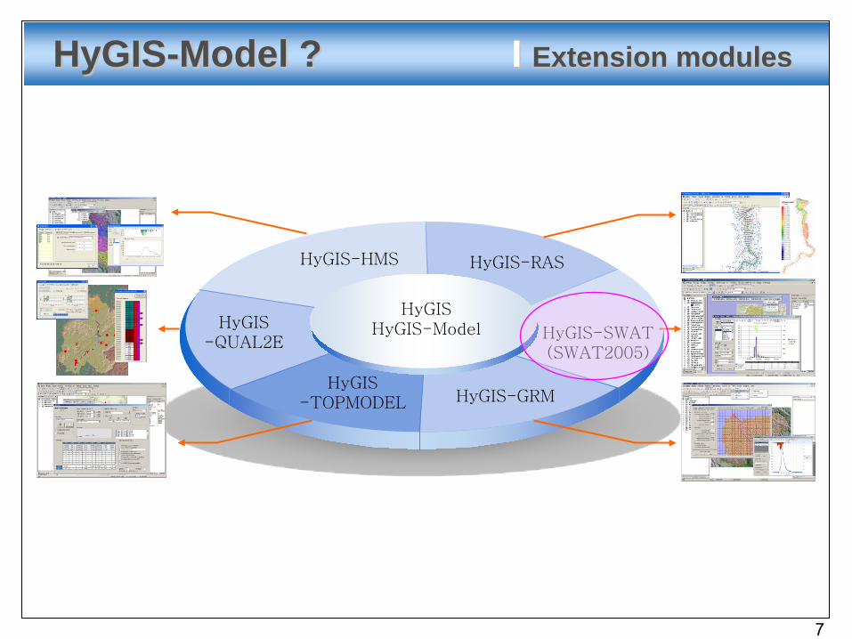
HyGIS-Model ? I Extension modules
HyGIS-RAS
HyGIS-QUAL2E
HyGIS-SWAT(SWAT2005)
HyGIS-HMS
HyGIS-TOPMODEL
HyGISHyGIS-Model
HyGIS-GRM
7
Page 8
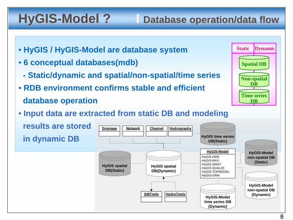
• HyGIS / HyGIS-Model are database system• 6 conceptual databases(mdb)- Static/dynamic and spatial/non-spatial/time series
• RDB environment confirms stable and efficientdatabase operation
• Input data are extracted from static DB and modelingresults are storedin dynamic DB
Spatial DB
Non-spatialDB
Time seriesDB
Static Dynamic
HyGIS-Model ? I Database operation/data flow
HyGIS spatialDB(Dynamic)
HyGIS spatial DB(Static)
HyGIS-Model-HyGIS-HMS-HyGIS-RAS-HyGIS-SWAT-HyGIS-QUAL2E-HyGIS-TOPMODEL-HyGIS-GRM
HyGIS-Modeltime series DB
(Dynamic)
HyGIS time series DB(Static)
Drainage ChannelNetwork Hydrography
HydroTools
HyGIS-Modelnon-spatial DB
(Static)
HyGIS-Modelnon-spatial DB
(Dynamic)GMTools
8
Page 9
SWAT
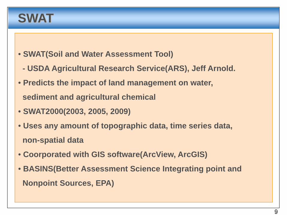
• SWAT(Soil and Water Assessment Tool)
- USDA Agricultural Research Service(ARS), Jeff Arnold.
• Predicts the impact of land management on water,
sediment and agricultural chemical
• SWAT2000(2003, 2005, 2009)
• Uses any amount of topographic data, time series data,
non-spatial data
• Coorporated with GIS software(ArcView, ArcGIS)
• BASINS(Better Assessment Science Integrating point and
Nonpoint Sources, EPA)
9
Page 10
SWAT I GIS-SWAT
• Srinivasan and Arnold (1994)- SWAT 1990 / GRASS – C programming language
• Bian et al. (1998)- SWAT 1990 / ArcInfo – Arc Macro Language(AML)
•Di Luzio et al. (1998) - SWAT 1996 / ArcView – Avenue•Di Luzio et al. (2002)
- SWAT 2000 / ArcView – Avenue(AVSWAT2000)•Di Luzio et al. (2002)
- Improved 1998 interface and was incorporated in BASINS(BASINS SWAT)
•Francisco Olivera and Milver Valenzuela(2004)- SWAT2000 / ArcGIS – Visual Basic(ArcGIS-SWAT)
•M. Winchell, R. Srinivasan, M. Di Luzio, J. Arnold(2008)- SWAT2005 / ArcGIS - ArcSWAT2.1
•M. Winchell, R. Srinivasan, M. Di Luzio, J. Arnold(2010)- SWAT2009 / ArcGIS – ArcSWAT2009
10
Page 11
HyGIS-SWAT ? I Overview
• HyGIS-SWAT
- for the SWAT2000 model in 2007(Ref. AVSWAT2000)
- for the SWAT2005 model in 2009
• Interface system to run SWAT2005 in HyGIS
• Make input files and treat modeling results
• Call SWAT2005.exe
• Using GDK(GEOMania
Development Kits) and
Visual Basic .NET
• Added on GMMap as
extension module
HyGIS
HyGIS-SWAT
11
Page 12
HyGIS-SWAT I Methodology
• Interchange- Separated GUI, interchanging input files by user
• Interface- Pre/post processing, running model, user interface
• Integration- Integrate more than one system into one system.
System2System1GISDB
User Interface
12
Page 13
HyGIS-SWAT I Environment
•HyGIS, HyGIS-Model- Interface system based on GIS and database
•Spatial database : GSS (from GEOMania GIS)- GEOMania Pro/3D, GMMap
•Non-spatial, timeseries database : MDB- MS Access
•Using GDK, VS2008, VB.NET (.NET framework 3.5)
13
Page 14
HyGIS-SWAT I Implementation
•Model(SWAT2005) analysis(vs. SWAT2000)
- Input/output files format, parameters
- New or removed variables/renamed or moved variables
- New input file, renamed filename, file format changes
- Applying sub-hourly precipitation
•Upgrade HyGIS-SWAT(for the SWAT2000)
- Visual basic 6 -> Visual basic .NET
- Add new GUIs, functions, and processes for
new variables and new input files format
14
Page 15
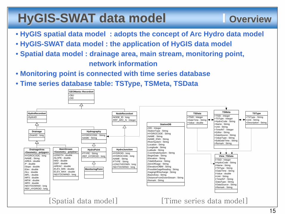
HyGIS-SWAT data model I Overview• HyGIS spatial data model : adopts the concept of Arc Hydro data model• HyGIS-SWAT data model : the application of HyGIS data model• Spatial data model : drainage area, main stream, monitoring point,
network information• Monitoring point is connected with time series database• Time series database table: TSType, TSMeta, TSData
+TSID : Integer+DateTime : String+Value : double
TSData+TSID : Integer+TSType : Integer+HydroCode : String+Name : String+Unit : String+TimeINT : Integer+Editor : String+DataSource : String+ValueType : String+EditDateTime : String+Remark : String
TSMeta
+TSType : String+Unit : String+Description : String
TSType
+TSID : Integer+HydroCode : String+Name : String+TSType : String+DateTime : String+Value : double+Unit : String+TimeINT : String-DataType : String+DataSource : String+Remark : String
View_TSData
-OID : Integer-StationType : String-HYDROCODE : String-NAME : String-NAME_ENG : String-RiverSystem : String-Location : String-Longitude : String-Latitude : String-CoordinateSystem : String-BeginDate : String-Elevation : String-TidalInfluence : String-ZeroOfGage : String-ElevationOfBM : String-PossibleGageReading : String-GagingOfDischarge : String-BasinArea : String-DistanceFromDownStream : String-Remark : String
StationDB
-OBJ-OID
GEOMania::Recordset
-HydroIDHydroRecordset
-DrainID : longDrainage
-NODE_ID : long-REF_ARC_N : Integer
NodeRecordset
-HYDROID : long-HYDROCODE : long-NAME : String-FTYPE : String-LENGTHDOWN : long-NEXTDOWNID : long
HydroJunction
-LENGTH : double-SLOPE : double-WID : double-DEP : double-AREAC : double-ELEV_MIN : double-ELEV_MAX : double-NEXTDOWNID : long
MainStream<Geometry : polyline>
-HYDROCODE : long-NAME : String-AREA : double-P : double-Slope : double-Elev : double-SLL : double-MFL : double-MFS : double-MFW : double-MFD : double-NEXTDOWNID : long-REF_HYDROID : long
DrainageArea<Geometry : polygon>
MonitoringPoint
-FTYPE : String-REF_HYDROID : long
HydroPoint
-HYDROCODE : String-NAME : String
Hydrography
[Spatial data model] [Time series data model]
15
Page 16
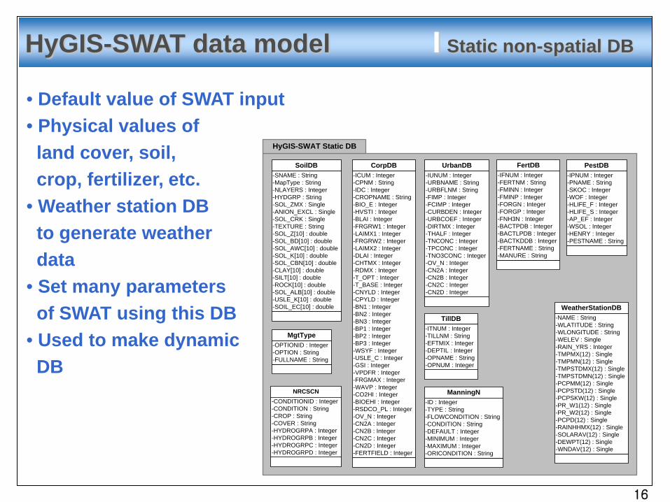
HyGIS-SWAT data model I Static non-spatial DB
HyGIS-SWAT Static DB
SoilDB-SNAME : String-MapType : String-NLAYERS : Integer-HYDGRP : String-SOL_ZMX : Single-ANION_EXCL : Single-SOL_CRK : Single-TEXTURE : String-SOL_Z[10] : double-SOL_BD[10] : double-SOL_AWC[10] : double-SOL_K[10] : double-SOL_CBN[10] : double-CLAY[10] : double-SILT[10] : double-ROCK[10] : double-SOL_ALB[10] : double-USLE_K[10] : double-SOIL_EC[10] : double
CorpDB-ICUM : Integer-CPNM : String-IDC : Integer-CROPNAME : String-BIO_E : Integer-HVSTI : Integer-BLAI : Integer-FRGRW1 : Integer-LAIMX1 : Integer-FRGRW2 : Integer-LAIMX2 : Integer-DLAI : Integer-CHTMX : Integer-RDMX : Integer-T_OPT : Integer-T_BASE : Integer-CNYLD : Integer-CPYLD : Integer-BN1 : Integer-BN2 : Integer-BN3 : Integer-BP1 : Integer-BP2 : Integer-BP3 : Integer-WSYF : Integer-USLE_C : Integer-GSI : Integer-VPDFR : Integer-FRGMAX : Integer-WAVP : Integer-CO2HI : Integer-BIOEHI : Integer-RSDCO_PL : Integer-OV_N : Integer-CN2A : Integer-CN2B : Integer-CN2C : Integer-CN2D : Integer-FERTFIELD : Integer
UrbanDB-IUNUM : Integer-URBNAME : String-URBFLNM : String-FIMP : Integer-FCIMP : Integer-CURBDEN : Integer-URBCOEF : Integer-DIRTMX : Integer-THALF : Integer-TNCONC : Integer-TPCONC : Integer-TNO3CONC : Integer-OV_N : Integer-CN2A : Integer-CN2B : Integer-CN2C : Integer-CN2D : Integer
FertDB-IFNUM : Integer-FERTNM : String-FMINN : Integer-FMINP : Integer-FORGN : Integer-FORGP : Integer-FNH3N : Integer-BACTPDB : Integer-BACTLPDB : Integer-BACTKDDB : Integer-FERTNAME : String-MANURE : String
PestDB-IPNUM : Integer-PNAME : String-SKOC : Integer-WOF : Integer-HLIFE_F : Integer-HLIFE_S : Integer-AP_EF : Integer-WSOL : Integer-HENRY : Integer-PESTNAME : String
TillDB-ITNUM : Integer-TILLNM : String-EFTMIX : Integer-DEPTIL : Integer-OPNAME : String-OPNUM : Integer
ManningN-ID : Integer-TYPE : String-FLOWCONDITION : String-CONDITION : String-DEFAULT : Integer-MINIMUM : Integer-MAXIMUM : Integer-ORICONDITION : String
WeatherStationDB-NAME : String-WLATITUDE : String-WLONGITUDE : String-WELEV : Single-RAIN_YRS : Integer-TMPMX(12) : Single-TMPMN(12) : Single-TMPSTDMX(12) : Single-TMPSTDMN(12) : Single-PCPMM(12) : Single-PCPSTD(12) : Single-PCPSKW(12) : Single-PR_W1(12) : Single-PR_W2(12) : Single-PCPD(12) : Single-RAINHHMX(12) : Single-SOLARAV(12) : Single-DEWPT(12) : Single-WNDAV(12) : Single
MgtType-OPTIONID : Integer-OPTION : String-FULLNAME : String
NRCSCN-CONDITIONID : Integer-CONDITION : String-CROP : String-COVER : String-HYDROGRPA : Integer-HYDROGRPB : Integer-HYDROGRPC : Integer-HYDROGRPD : Integer
• Default value of SWAT input• Physical values of land cover, soil, crop, fertilizer, etc.
• Weather station DBto generate weatherdata
• Set many parametersof SWAT using this DB
• Used to make dynamic DB
16
Page 17
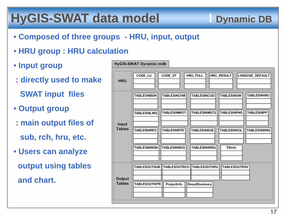
HyGIS-SWAT data model I Dynamic DB
• Composed of three groups - HRU, input, output
• HRU group : HRU calculation
• Input group
: directly used to make
SWAT input files
• Output group
: main output files of
sub, rch, hru, etc.
• Users can analyze
output using tables
and chart.
17
Page 18
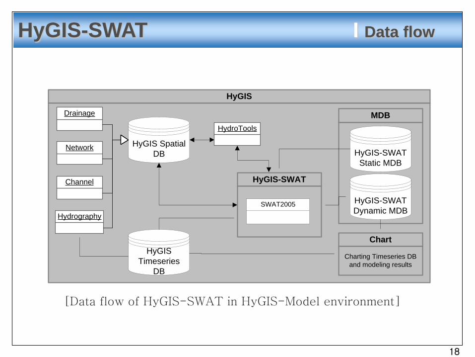
HyGIS-SWAT I Data flow
HyGIS
Drainage
Channel
Network
Hydrography
HyGIS Spatial DB
HyGIS-SWAT
SWAT2005
HyGIS Timeseries
DB
HydroTools
MDB
HyGIS-SWAT Static MDB
HyGIS-SWAT Dynamic MDB
Chart
Charting Timeseries DB and modeling results
[Data flow of HyGIS-SWAT in HyGIS-Model environment]
18
Page 19
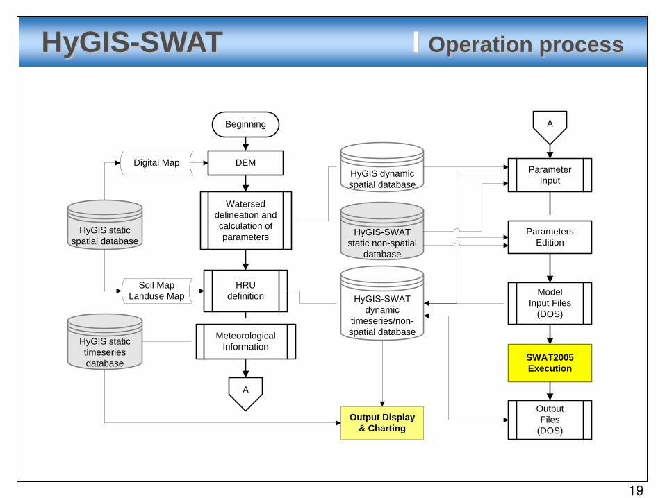
A
HyGIS statictimeseries database
ModelInput Files
(DOS)
SWAT2005Execution
OutputFiles
(DOS)
Digital Map DEM
Beginning
Watersed delineation and calculation of parameters
HyGIS dynamicspatial database
HRUdefinition
Soil MapLanduse Map
HyGIS staticspatial database
A
HyGIS-SWATdynamic
timeseries/non-spatial databaseMeteorological
Information
HyGIS-SWATstatic non-spatial
database
Output Display& Charting
ParametersEdition
ParameterInput
HyGIS-SWAT I Operation process
19
Page 20
HyGIS-SWAT I Operation process
20
Page 21
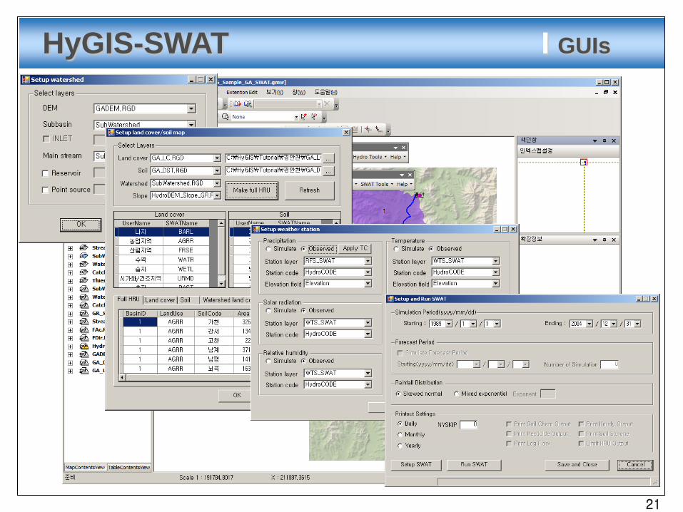
HyGIS-SWAT I GUIs
21
Page 22
Develop the HyGIS-SWAT system
Provide easy and convenient modeling environment with
GIS and database
Can make effectively the input database of SWAT model
appropriate to Korea
Obtain the technology for the nation wide modeling support
system based on GIS and database
Expect to be used as the convenient tool for applying the
SWAT model
Conclusions
22
Page 23
23/26
THANK YOU…(http://hygis.kict.re.kr)