JEM — VOLUME 10, NUMBER 1 Smerdon, B.D., T.E. Redding, and J. Beckers. 2009. An overview of the effects of forest management on groundwater hydrology. BC Journal of Ecosystems and Management 10(1):22–44. www.forrex.org/publications/jem/ISS50/vol10_ no1_art4.pdf Published by FORREX Forum for Research and Extension in Natural Resources Discussion Paper BC Journal of Ecosystems and Management An overview of the effects of forest management on groundwater hydrology Brian D. Smerdon 1 , Todd E. Redding 2 , and Jos Beckers 3 Abstract is paper provides an introduction to the role of groundwater in watersheds, presents an overview of groundwater resources in British Columbia, and reviews the potential effects of forest management activities (e.g., harvest operations, road building, reforestation, management of mountain pine beetle infestation) on groundwater hydrology. A regional-scale classification of hydrogeologic landscapes for British Columbia is outlined, integrating major physiographic, biogeoclimatic, and groundwater regions. e classification considers characteristics of climate, geology, aquifer type, and interaction with surface water in a generalized way, and summarizes broad-scale expectations about the groundwater hydrology in each hydrogeologic landscape category. In all of the landscapes, a rise in the water table can be expected to follow forest harvesting, though the magnitude and duration of this increase vary according to the area’s geology and topography. In wet, steep watersheds, for example, shallow groundwater flow is likely to increase, in turn leading to the potential for increased runoff and decreased slope stability. Local-scale water table changes are oſten more apparent than those at the regional scale. keywords: forest harvesting, groundwater recharge, hydrogeology, hydrology, watershed management. Contact Information 1 Consulting Hydrogeologist, WorleyParsons Komex, 8658 Commerce Court, Burnaby, BC V5A 4N6. 2 Watershed Management Extension Specialist, FORREX Forum for Research and Extension in Natural Resources, Suite 702, 235 1st Avenue, Kamloops, BC V2C 3J4. Email: [email protected]3 Consulting Hydrogeologist, WorleyParsons Komex, 8658 Commerce Court, Burnaby, BC V5A 4N6.
Transcript
22 JEM — VoluME 10, NuMbEr 1
smerdon, redding, and beckers
JEM — VoluME 10, NuMbEr 1
Smerdon, B.D., T.E. Redding, and J. Beckers. 2009. An overview of the effects of forest management on groundwater hydrology. BC Journal of Ecosystems and Management 10(1):22–44. www.forrex.org/publications/jem/ISS50/vol10_no1_art4.pdf
Published by Forrex Forum for research and extension in Natural resources
Discussion PaperBC Journal of Ecosystems and Management
An overview of the effects of forest management on groundwater hydrology Brian D. Smerdon1, Todd E. Redding2, and Jos Beckers3
AbstractThis paper provides an introduction to the role of groundwater in watersheds, presents an overview of groundwater resources in British Columbia, and reviews the potential effects of forest management activities (e.g., harvest operations, road building, reforestation, management of mountain pine beetle infestation) on groundwater hydrology. A regional-scale classification of hydrogeologic landscapes for British Columbia is outlined, integrating major physiographic, biogeoclimatic, and groundwater regions. The classification considers characteristics of climate, geology, aquifer type, and interaction with surface water in a generalized way, and summarizes broad-scale expectations about the groundwater hydrology in each hydrogeologic landscape category. In all of the landscapes, a rise in the water table can be expected to follow forest harvesting, though the magnitude and duration of this increase vary according to the area’s geology and topography. In wet, steep watersheds, for example, shallow groundwater flow is likely to increase, in turn leading to the potential for increased runoff and decreased slope stability. Local-scale water table changes are often more apparent than those at the regional scale.
Contact Information1 Consulting Hydrogeologist, WorleyParsons Komex, 8658 Commerce Court, Burnaby, BC V5A 4N6.2 Watershed Management Extension Specialist, FoRREx Forum for Research and Extension in Natural Resources,
Suite 702, 235 1st Avenue, Kamloops, BC V2C 3J4. Email: [email protected] Consulting Hydrogeologist, WorleyParsons Komex, 8658 Commerce Court, Burnaby, BC V5A 4N6.
an overview of the effects of forest management on groundwater hydrology
Introduction
Groundwater, generally defined as water occurring beneath the land surface, is a valuable, renewable but “hidden” natural
resource. Groundwater contributes to runoff generation from headwater hillslopes (Moore and Wondzell 2005), strongly influences slope stability (Sidle and ochiai 2006), and is critically important to ecosystems across the Pacific Northwest (Brown et al. 2007). It provides water supply as baseflow during the low-flow season (Pike and Scherer 2003), regulates stream temperature by providing cool water inputs (Moore et al. 2005), and delivers nutrients that are important for the ecology of riparian zones and wetlands (Devito et al. 1996; Freeman et al. 2007).
Groundwater is also important from a human perspective. In some areas of British Columbia, it is the only viable source for individual and community water supply systems, as well as for agricultural and industrial uses. For the entire province, groundwater sources are estimated to supply about 25% of the total municipal water demand (British Columbia Ministry of Environment 1994). As surface water supplies in the province become fully allocated, water managers and individual users are increasingly turning to groundwater to meet future demands.
over the years, many researchers have invested significant effort in trying to better understand how groundwater resources can be sustained for human use and protected from over-exploitation and pollution. Nevertheless, comparatively little is yet known about the potential interactions between forest management activities and groundwater systems. In the Interior of British Columbia, the need for both greater knowledge of the effects of forest management on groundwater and an improved inventory of groundwater resources has been identified (Pike and Scherer 2003; Redding and Nickurak 2008; Redding et al. 2008). Several studies suggest that forestry-related activities—including harvesting, road building, and alteration of upland creeks—do impact the groundwater regime and subsequently streamflow (e.g., Pike and Scherer 2003). At the same time, other studies have shown that changes in groundwater regime on some sites can impact future forest productivity. For example, research by Rex and Dubé (2006) suggests that in stands killed by the recent large-scale mountain pine beetle
infestation in the central Interior, groundwater regimes may be changing enough to result in the wetting-up of sites that in turn may limit salvage-harvesting activities and forest regeneration success.
Few published case studies on the effect of forest management activities on groundwater regime (e.g., aquifers) exist. This discussion paper aims to address that gap by increasing awareness of the importance of groundwater hydrology in watersheds. Better defining of the role of groundwater in a watershed context will, we hope, assist scientists and forest managers in anticipating changes caused by management activities. This is especially important given that, under the provincial Forest and Range Practices Act (British Columbia Ministry of Forests and Range 2002), recognizing the impact of forest practices is critical to ensuring core resource values are protected. With groundwater’s wide-ranging influence—on, for example, streamflows, slope stability, water quality, wetland sustainability, and operational activities such as site access and silvicultural options—better understanding of this resource is required if resource planning is to achieve sustainable forest management.
The specific objectives of this discussion paper are to:
• introducetheprinciplesofgroundwaterhydrologyand the role of groundwater in the hydrologic cycle;
• introducetheconceptofhydrogeologic1 landscapes (i.e., distinct groundwater regions) in the province;
1 Hydrogeology is the study of the distribution and movement of groundwater in the subsurface.
With groundwater’s wide-ranging influence—on, for example, streamflows,
slope stability, water quality, wetland sustainability, and operational activities
such as site access and silvicultural options—better understanding of this
resource is required if resource planning is to achieve sustainable forest management.
24 JEM — VoluME 10, NuMbEr 1
smerdon, redding, and beckers
• summarizefindingsoftheliteratureonthehydrogeologic effects resulting from forest harvesting and road building; and
• outlinethepotentialimplicationsofforestmanagement activities (e.g., harvest operations, road building, and revegetation) on groundwater hydrology variables such as low flows, groundwater recharge, and water residence times.our intent was not to make specific predictions
for various forestry activities, but rather to provide a conceptual framework for use in evaluating potential groundwater–forestry interactions and to focus future research efforts. This approach will, we hope, offer forest management planners and others insight into the complex groundwater dependency of watershed core resource values that should be considered if groundwater is to be protected, and the ecosystems and communities that depend on it.
Groundwater hydrology background
“Groundwater” means more than just “water below the ground.” According to the US Geological Survey, groundwater is water that occurs within the zone of saturation beneath the Earth’s surface (Meinzer 1923). This definition is still used in many introductory references on hydrogeology (e.g., Freeze and Cherry 1979; Fetter 2001). It would be an oversimplification, however, to think that groundwater is any water occurring in the ground. Rather, it is the liquid water that completely fills pore spaces in the subsurface. It is the water occurring within the saturated zone, where pore pressure is equal to or greater than atmospheric pressure (Figures 1 and 2). Recent introductions to groundwater hydrology have been published by Smerdon and Redding (2007) and Anderson (2007).
figure 1. Components of the hydrologic cycle within a watershed. Groundwater flow lines are denoted by solid blue arrows. Contours of equal hydraulic head are denoted by dashed blue lines in the saturated zone.
25JEM — VoluME 10, NuMbEr 1
an overview of the effects of forest management on groundwater hydrology
figure 2. Groundwater flow system with water table, aquifers, and aquitards. Local flow systems occur close to the stream and have short travel times (days) relative to regional flow systems which have longer travel times (decades to centuries). Side schematics illustrate the difference between the unsaturated and saturated zones (left) and components of hydraulic head (right).
All geologic materials are composed of solids (i.e., actual grains, sediment, or rock matrix) and pore space (i.e., voids). The volume of available pore space, the size of pores, and the interconnectivity of pores in the rock, soil, or sediment are three of the main factors governing the storage and transmission of groundwater. If the pore spaces in a porous medium are filled with liquid, then the medium is considered to be saturated. Alternatively, if the pores are filled with air, the material is considered to be unsaturated (Figure 2). The division between zones of the subsurface that are unsaturated and zones that are saturated depends on the location of the water table. At the top of the saturated zone, the pore water pressure is equal to atmospheric pressure. Below the water table, the pore water pressure is greater than atmospheric pressure. It is the spatial and temporal differences in pore water pressure that create the potential for groundwater to flow.
The magnitude and direction of groundwater flow is driven by differences in the potential energy supplied by elevation and pore water pressure (termed “total hydraulic head”). The magnitude of flow varies according to the magnitude of the gradient in hydraulic head and the ability of the porous medium to transmit water (i.e., its “hydraulic conductivity”).
Subsurface materials (soil and rock) can be defined by their ability to store and transmit water. An aquifer
is a geologic unit of porous material that can transmit “significant” quantities of water to a well, spring, or surface water body. Usually, aquifers are composed of:
(e.g., granitic and metamorphic rocks) but that have become fractured.
often, what constitutes a “significant” quantity of water is defined based on human need rather than on an absolute standard.
An aquitard is a saturated geologic unit that restricts the flow of groundwater from one aquifer to another, and is incapable of transmitting useful quantities of water. Typically, aquitards are composed of clay, silt, shale, or other dense geologic materials that are less permeable than aquifer materials.
Aquifers may be unconfined (those permeable geologic units open to the atmosphere where the water table forms the upper boundary) or confined (those covered by an aquitard), as illustrated on Figure 2. Additionally, aquifers and aquitards may have preferential flow pathways, such as fractures in bedrock or macropores, which allow water to be transported
26 JEM — VoluME 10, NuMbEr 1
smerdon, redding, and beckers
at higher rates than to that in the surrounding soil or rock matrix. It is along these pathways that runoff generation and the transport of solutes (e.g., nutrients and pollutants) often occurs from hillslopes to the water table or surface waters.
In some situations, an isolated unit of saturated material may become “perched” above a deeper, regional water table. This occurs when a saturated zone develops atop a layer of low hydraulic conductivity unsaturated material (called a perching layer). Perched water tables are often transient features, occurring seasonally or after a storm event. They are common in environments with high rainfall and shallow permeable soils over less permeable substrates.
Role of groundwater in watersheds
A watershed is made up of a surface drainage network (streams) and the underlying subsurface geologic framework (aquifers and aquitards) that constitute the terrestrial portion of the hydrologic cycle. Water that infiltrates the ground surface and moves vertically through the unsaturated zone is referred to as “unsaturated flow” or “percolation.” When it reaches the water table, thus entering the saturated zone, it becomes “groundwater recharge.” Although often used interchangeably, there is a distinction between the terms infiltration, unsaturated flow, and recharge when used to describe water flowpaths.
Within a watershed, regions where water is infiltrating and percolating to the groundwater regime are termed “recharge areas.” Groundwater flows from areas of high hydraulic head to areas of low hydraulic head, typically as a result of a decrease in elevation or in pore pressure (e.g., caused by pumping groundwater from a well). In natural settings, groundwater may reach the surface and discharge to springs, streams, or wetlands (Figures 1 and 2). Travel times of groundwater from recharge to discharge areas may be as short as days or as long as centuries, depending on the hydraulic conductivity of the soils and rocks and on whether flow occurs through shallow, local-scale flow systems or deeper, regional-scale systems (Toth 1962). In general, however, travel times for groundwater are much longer than for water flowing through streams in the surface drainage network.
Water is constantly moving through a watershed (Figure 1). The inflow is supplied by precipitation (usually rain and snow). The outflow occurs by evapotranspiration and discharge into basin outlets
through surface and groundwater pathways. For any given timeframe, the difference between inflow and outflow is stored in the watershed in the subsurface unsaturated and saturated zones, in vegetation, and in surface water bodies. Averaged over sufficiently long timeframes (e.g., years or decades), changes in the amount of water stored in a watershed are small, with inflow balancing outflow (ignoring any effects of long-term climate changes).
The general equation for the water balance (or “water budget”) in a watershed helps illustrate water movement:
I – O = ∆Swhere: I = inflows, O = outflows, and ∆S = change in storage.
The science of hydrogeology (the study of groundwater) applies this water budget principle to subsurface regions that are saturated. Inflow is supplied by recharge and outflow leaves by discharge to surface waters or by the pumping of water out of wells. one factor complicating the balance is that surface drainage networks and groundwater flow systems (recharge and discharge zones) do not always have the same catchment area (Winter et al. 2003). Furthermore, a well-defined surface water catchment area may not be the same as the groundwater catchment area in that region, which is controlled by both topography and geology.
In a watershed, the subsurface geologic framework interacts with the overlying surface drainage network. The exchange of surface water and groundwater can be quite complex because surface water bodies, such as streams and rivers, may be both sources and sinks for groundwater (Figure 3). Gaining streams receive discharge from groundwater when the stage of the stream is lower than the elevation of the water table. Conversely, losing streams recharge groundwater when the stage is higher than hydraulic heads in adjacent groundwater. Such conditions may occur, for example, on an alluvial fan. This is a common source of groundwater recharge for many valley-bottom aquifers in British Columbia. Because of the variability that exists in subsurface materials (soils and [or] rock) and topography in a watershed, streams and rivers can have reaches or sections that are gaining or losing (Winter 1999). The same reach can be gaining or losing at different times of the year. The amount of groundwater that discharges to a stream is commonly referred to as the stream’s “baseflow.” Baseflow is important for maintaining streamflow volumes during dry times of the year.
27JEM — VoluME 10, NuMbEr 1
an overview of the effects of forest management on groundwater hydrology
figure 3. Examples of surface-water–groundwater interaction for gaining and losing streams.
Given the comparatively long travel times for groundwater, baseflow amount is typically not determined by specific storm events or seasonal phenomena such as snowmelt. Rather, it reflects the amount of groundwater recharge that occurred in previous years.
Groundwater in British Columbia
In British Columbia, the Water Stewardship Division of the British Columbia Ministry of Environment is responsible for assessment, inventory, and governance of groundwater resources (for more information, go to: www.env.gov.bc.ca/wsd/plan_protect_sustain/groundwater/index.html). Protection and regulation
of groundwater is legislated through the Water Act (BC Regulation 299/2004; British Columbia Ministry of Environment 2004), which specifies codes of practice for the development and protection of water wells and sets the qualification requirements of well drillers/installers and groundwater professionals. The Water Act does not require a groundwater user to have a licence. However, any waterworks system servicing more than three households is regulated under the Health Act, Sanitary Regulations (BC Regulation 142/59; British Columbia Ministry of Health 1996), and requires a permit. Remediation of groundwater contamination is regulated under the Contaminated Sites Regulation of the Environmental Management Act (BC Regulation 375/96; British Columbia Ministry of Environment 2003), which
sets standards for groundwater quality based on its likely uses (e.g., as drinking water, to support aquatic life, or to supply agricultural purposes).
Groundwater inventory and assessment activities in the province have typically been limited to populated areas. The British Columbia Ministry of Environment’s Water Stewardship Division maintains a water well database, observation well network, and aquifer classification system to aid groundwater resources management. These tools can be viewed on the BC Water Resource Atlas (for more information, go to: www.env.gov.bc.ca/wsd/data_searches/wrbc/index.html). The ministry’s WELLS Database also contains legal descriptions of wells, well locations, and well construction details for more than 85 000 water wells in the province, and has been used to identify, map, and categorize more than 800 individual aquifers (BC Aquifer Classification System and Maps). In addition, the ministry maintains nearly 200 observation wells to monitor groundwater levels and support assessment of impact to groundwater in targeted areas.
Hydrogeologic landscapes of British Columbia
British Columbia’s physiographic setting includes mountain ranges, highland plateaus, and valleys that have developed over millions of years (Church and Ryder 2007). Throughout the province’s geologic history, tectonic events and glaciations have resulted in complex sedimentary deposits and rock formations that form diverse hydrogeologic settings. Information on the groundwater resources of British Columbia is limited primarily to settled areas. Vast portions of the province are relatively undeveloped and thus have little exploratory information pertaining to hydrogeology. Therefore, a first step in assessing the nature of groundwater resources in British Columbia and the potential impacts of forest management practices on those resources is to gain an understanding of the climatic, physiographic, and geologic setting (Livingstone 1994; Winter 2001; Devito et al. 2005a).
To do this, we started by devising a regional-scale classification of hydrogeologic landscapes for British Columbia (Figure 4). This allowed us to provide a framework in which to synthesize findings from those few studies that have directly addressed forest management impacts to groundwater. The classification incorporates a combination of the major physiographic
units (Church and Ryder 2007), groundwater regions (Foweraker 1994), and biogeoclimatic zones of the province. It also generally follows both a climatic gradient (i.e., from very humid to semi-arid) and topographic gradient (i.e., from steep mountain regions to broad plains). For each of the seven hydrogeologic landscapes identified, the general characteristics of climate, geology, and interaction with surface water are described, similar to the Fundamental Hydrologic Landscape Units approach of Winter (2001).
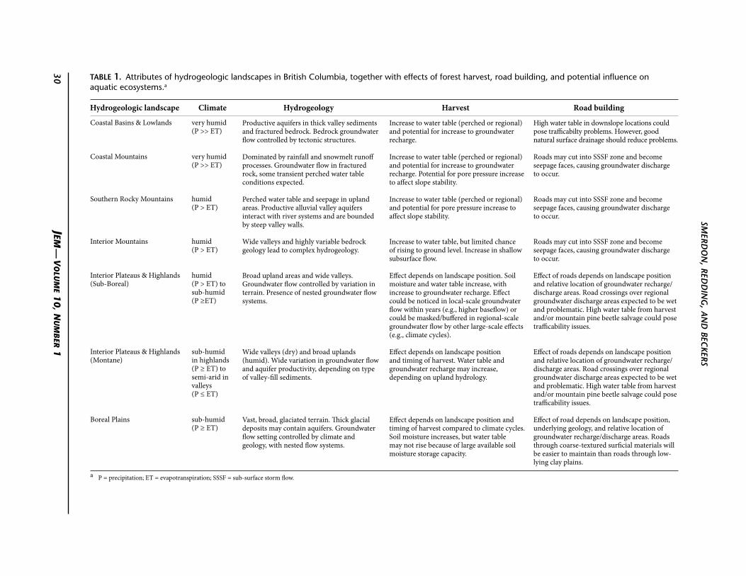
Within each broad-scale hydrogeologic landscape described below, the types of aquifers occurring in them also have unique characteristics that could be investigated at a finer level of detail. For example, a formal characterization of aquifers has been proposed by Wei et al. (2007) for the Cordilleran region, and includes six main aquifer types (four with sub-categories). Although the broad hydrogeologic landscape categories presented here are at a larger scale than is directly applicable for specific forest management investigations, the characteristics of each are distinct, and allow integration of knowledge gained from studies in other areas. Table 1 summarizes the characteristics of each of the seven hydrogeologic landscapes.
Coastal Basins & Lowlands
This region, located along the mainland and island coasts of the province, contains very productive temperate rain forests of hemlock and Douglas-fir. It is characterized by a rainfall-dominated and humid climate (annual precipitation is much greater than potential evapotranspiration), which drives a hydrologic system dominated by surface water and near-surface flows (runoff). However, the region also contains alluvial valley and fractured bedrock aquifers, which are major drinking water resources for the lower Fraser Valley of the southwest British Columbia mainland and the Gulf Islands (Dakin et al. 1994). Bedrock groundwater flow is controlled by the prevalence of intrusive igneous and foliated metamorphic rocks in which tectonic stresses have established fractures and faulting. Alluvial aquifers generally contain thick deposits of sand and gravel bounded by coastal mountains.
Coastal Mountains
The Coastal Mountains rise to about 2000 m above sea level. orographic precipitation (as rain and snow) and a significant snowpack characterize the region. The British Columbia Ministry of Environment has not
an overview of the effects of forest management on groundwater hydrology
figure 4. Hydrogeologic landscapes for British Columbia, indicating general variations in depth of the water table and types of groundwater flow systems that may develop. Letters shown within the map are short forms for each landscape: CB+L – Coastal Basins & Lowlands; Cm – Coastal mountains; ip+H(m) – interior plateaus & Highlands (montane); ip+H(SB) – interior plateaus & Highlands (Sub-Boreal); im – interior mountains; Srm – Southern rocky mountains; and Bp – Boreal plains.
mapped many aquifers in coastal mountains. However, groundwater flow likely occurs in the upper portions of bedrock (Parsons and Quinn 1994), which is fractured and faulted as has occurred in the Coastal Lowlands. The bedrock here is intrusive igneous and foliated metamorphic rocks, with faulted lava flows present on coastal islands and some inland regions (e.g., Squamish area). Considering the relatively steep topography in this region, many of these flow systems may be perched and have localized seepage areas. Rapid runoff (from rainfall
or snowmelt), very shallow subsurface (possibly perched) flow, and surface water dominate the hydrologic regime.
Southern rocky Mountains
The faulted and folded sedimentary mountains of southeast British Columbia rise to more than 2500 m above sea level. orographic precipitation characterizes the region, falling as snow in the winter and rain from convective storms in the summer. The timing of snowmelt plays a major role in the hydrology.
JEM —
Vo
luM
E 10, N
uM
bEr 1
smerd
on
, redd
ing, a
nd bec
kers
30
Coastal Basins & Lowlands
Coastal Mountains
Southern Rocky Mountains
Interior Mountains
Interior Plateaus & Highlands (Sub-Boreal)
Interior Plateaus & Highlands (Montane)
Boreal Plains
very humid (P >> et)
very humid (P >> et)
humid (P > et)
humid (P > et)
humid (P > et) to sub-humid (P ≥et)
sub-humid in highlands (P ≥ et) to semi-arid in valleys (P ≤ et)
sub-humid (P ≥ et)
Productive aquifers in thick valley sediments and fractured bedrock. Bedrock groundwater flow controlled by tectonic structures.
Dominated by rainfall and snowmelt runoff processes. Groundwater flow in fractured rock, some transient perched water table conditions expected.
Perched water table and seepage in upland areas. Productive alluvial valley aquifers interact with river systems and are bounded by steep valley walls.
Wide valleys and highly variable bedrock geology lead to complex hydrogeology.
Broad upland areas and wide valleys. Groundwater flow controlled by variation in terrain. Presence of nested groundwater flow systems.
Wide valleys (dry) and broad uplands (humid). Wide variation in groundwater flow and aquifer productivity, depending on type of valley-fill sediments.
Vast, broad, glaciated terrain. Thick glacial deposits may contain aquifers. Groundwater flow setting controlled by climate and geology, with nested flow systems.
Increase to water table (perched or regional) and potential for increase to groundwater recharge.
Increase to water table (perched or regional) and potential for increase to groundwater recharge. Potential for pore pressure increase to affect slope stability.
Increase to water table (perched or regional) and potential for pore pressure increase to affect slope stability.
Increase to water table, but limited chance of rising to ground level. Increase in shallow subsurface flow.
effect depends on landscape position. Soil moisture and water table increase, with increase to groundwater recharge. effect could be noticed in local-scale groundwater flow within years (e.g., higher baseflow) or could be masked/buffered in regional-scale groundwater flow by other large-scale effects (e.g., climate cycles).
effect depends on landscape position and timing of harvest. Water table and groundwater recharge may increase, depending on upland hydrology.
effect depends on landscape position and timing of harvest compared to climate cycles. Soil moisture increases, but water table may not rise because of large available soil moisture storage capacity.
High water table in downslope locations could pose trafficabilty problems. However, good natural surface drainage should reduce problems.
Roads may cut into SSSf zone and become seepage faces, causing groundwater discharge to occur.
Roads may cut into SSSf zone and become seepage faces, causing groundwater discharge to occur.
Roads may cut into SSSf zone and become seepage faces, causing groundwater discharge to occur.
effect of roads depends on landscape position and relative location of groundwater recharge/discharge areas. Road crossings over regional groundwater discharge areas expected to be wet and problematic. High water table from harvest and/or mountain pine beetle salvage could pose trafficability issues.
effect of roads depends on landscape position and relative location of groundwater recharge/discharge areas. Road crossings over regional groundwater discharge areas expected to be wet and problematic. High water table from harvest and/or mountain pine beetle salvage could pose trafficability issues.
effect of road depends on landscape position, underlying geology, and relative location of groundwater recharge/discharge areas. Roads through coarse-textured surficial materials will be easier to maintain than roads through low-lying clay plains.
table 1. Attributes of hydrogeologic landscapes in British Columbia, together with effects of forest harvest, road building, and potential influence on aquatic ecosystems.a
a P = precipitation; et = evapotranspiration; SSSf = sub-surface storm flow.
Hydrogeologic landscape Climate Hydrogeology Harvest Road building
31JEM — VoluME 10, NuMbEr 1
an overview of the effects of forest management on groundwater hydrology
The hydrogeology of the region is thought to be similar to that in the Coastal Mountains region (i.e., having perched flow systems and seepage areas), but with the addition of karst bedrock and wider alluvial valleys bounded by steep mountain walls. Surface flow and shallow groundwater recharge the alluvial valley aquifers, which in turn interact with the major river systems that experience snowmelt-dominated streamflow regimes. Thus, the hydrogeologic regime in this region is likely one of dynamic interaction between surface water and groundwater.
Interior Mountains
The remaining mountains of the interior—Cariboo and Northern Rocky Mountains—have similar orographic precipitation and general landform shape as the Southern Rocky Mountains. More than half of the annual precipitation falls as snow, thus driving a snowmelt-dominated hydrologic setting. Very little is known about the hydrogeology of the region, and the geologic setting is complex including, for example, karst bedrock in the Northern Rocky Mountains. Groundwater systems are generally thought to be similar to those in the Southern Rockies, with the relatively steep mountains contributing seasonal flow to thick valley aquifers. The interior mountain ranges are headwaters for major river systems.
Interior Plateaus & Highlands (Sub-Boreal)
In the central and northern portion of the province, broad upland areas of flat-lying lava flows are covered by sub-boreal spruce forests. The region is characterized by a humid to sub-humid climate and a broad, rolling topography with wide river valleys. The variations in climate and topography favour the formation of “nested” groundwater flow regimes: local-scale groundwater flow may originate and terminate in highland areas, and regional-scale systems may drive deeper groundwater flow to sedimentary aquifers in the valley bottom.
Interior Plateaus & Highlands (Montane)
In the southern portion of the province, a warmer and drier climate supports montane forests of lodgepole pine and Douglas-fir. As in the Sub-Boreal region, wide valleys rise to broad rolling uplands. However, the valleys are typically dry (semi-arid) compared with upland areas. The presence of populated areas along the valley bottoms and a growing concern for residential, industrial, and agricultural water demands have generated considerable knowledge of groundwater resources, especially among people in the okanagan
Basin. The interactions between snowmelt-driven upland forest watersheds and arid valley bottoms create a wide variety of groundwater conditions. The uplands are composed of fractured bedrock; and the valley bottoms have been filled in with a thick, complex arrangement of sediments from repeated glaciation and alluvial processes. Although knowledge about the hydrologic connection between uplands and valley bottoms is limited, the assumption is that the highlands have perched groundwater conditions and a complex relationship between runoff from headwater catchments and groundwater recharge. Seasonal surface runoff (e.g., in alluvial fan settings) and deeper groundwater flow (e.g., mountain block recharge) are expected to recharge valley-bottom aquifers.
Boreal Plains
The northeast section of the province is covered by a small portion of the Boreal Plains, which are characterized by thick glacial sediments over generally flat-lying sedimentary bedrock. The climate is generally sub-humid, and soil water storage, groundwater flow, and evapotranspiration dominate annual water budgets. In general, the surface water storm runoff potential is minimal because of the flat-lying terrain. Consequently, there are numerous wetlands, ponds, and lakes on the landscape. Gentle undulating topography combined with a wide array of landform textures (ranging from coarse-textured outwash to fine-textured glaciolacustrine) produces a range of nested groundwater flow systems and complex interactions between groundwater and surface water.
In summary, these seven hydrogeologic landscapes represent a cross-section of broad-scale groundwater movement for distinct regions in British Columbia (Table 1; Figure 4). Each region has unique characteristics that control subsurface flow. The underlying differences in climate and terrain result in distinct groundwater flow systems that may in turn be affected differently by forest management activities.
The effects of forest management activities on groundwater: Literature review
There is a large body of research into the effects of forest management on surface hydrological processes, hillslope runoff, slope stability, and riparian zone processes. overviews of streamflow, runoff generation, low flows, and hyporheic exchange have been completed by, among others, Moore and Wondzell (2005), Pike and Scherer
32 JEM — VoluME 10, NuMbEr 1
smerdon, redding, and beckers
(2003), and Bonell (1993). Few studies, however, have focused on the direct link between forest management activities and groundwater (Tables 2 and 3). Although exact effects would largely depend on site-specific watershed characteristics, the same factors that underpin the hydrogeologic landscapes classification (Table 1; Figure 4) come into play. We therefore summarize results for the studies on the effects of forestry on groundwater in the context of these hydrogeologic landscapes.
other criteria guided our literature review:• Inmostofourreview,wefocusedonliterature
pertaining to groundwater regimes, including
table 2. Summary of literature review: Harvest impact on water table.
Average annual Management Water tableSource Study site Location precipitation (mm) practicea change
Bliss and Comerford (2002)
— Gainesville, Florida
1150 CC A 21–49 cm rise after 900 days. Larger seasonal fluctuations observed for 4 years following harvest.
Dubé et al. (1995)
Beaurivage Forest
St. Lawrence lowlands, Quebec
957 CC A 7–52 cm rise, depending on soil texture.
Pothier et al. (2003)
Villroy St. Lawrence lowlands, Quebec
510 PC + CC Up to 22-cm rise in cut areas. Water table rise increased linearly with percentage of cut area in the first year following harvest. Five years after harvest, water tables remained elevated, but less dependent on the percentage of area cut.
Fannin et al. (2000)
Carnation Creek
Vancouver Island, British
Columbia
2100–4800 CC A 50–150 cm rise (approx.) following individual storm events. Large spatial variability because of soil conditions, but all water table response was rapid. An upper limit to pressure head increase was observed, above which preferential flow pathways activated.
Hetherington (1998)
Carnation Creek
Vancouver Island, British
Columbia
2100–4800 CC A 30–50 cm rise that persisted for 10 years following harvest.
Megahan (1983)
Pine Creek central Idaho 890 CC (+ burned) A 90-cm rise in water table, decreasing to approx. 40 cm after 2 years. A 41% increase in snow accumulation in cut area.
Rockefeller et al. (2004)
— northern Idaho 1050 CC Perched water table approx. 8 cm higher in cut area. Perched water table had earlier formation and longer duration in cut area compared with uncut area.
Rex and Dubé (2006)
Vanderhoof Forest
District
central British Columbia
496 CC + mountain pine beetle
A 10-cm (approx.) higher water table in toe-slope of cut area compared to area killed by mountain pine beetle. A 30-cm (approx.) higher water table in upland of cut area compared to area killed by mountain pine beetle.
Peck and Williamson (1987)
Collie River Basin
Western Australia
820–1120 CC + PC A 100–40 cm rise following wet season. Water table increased by 260 cm/yr in clearcut areas and 90 cm/yr in partially cleared areas.
Evans et al. (2000)
TRoLS Lac La Biche, Alberta
468 PC Was 26 cm higher in cut area compared to uncut area.
Urie (1971) — northwest Michigan
790 PC A 100-cm (approx.) rise as a result of higher snowpack in strip cut areas.
a CC = clear cut; PC = partially cut.
observed changes to the position of the water table, estimated changes to groundwater recharge (in some cases inferred from changes in water yield), and changes in baseflow to streams. We also looked at articles dealing with hydrological processes, such as hillslope runoff and changes in the unsaturated zone, but we were mainly interested in data on saturated zone processes and recharge.
• SimilartowhatPikeandScherer(2003)didintheir review, we considered three aspects of forest management: timber harvest, road construction, and silviculture activities. We found that most of
33JEM — VoluME 10, NuMbEr 1
an overview of the effects of forest management on groundwater hydrology
the literature we reviewed was related to the first aspect—the effect of timber harvest.
• Giventhescarcityofgroundwaterandforestrystudies, we considered studies from nearly any geographic location, but with a goal of transposing findings to British Columbia conditions using the hydrogeologic landscape perspective. The purpose of this approach was to determine the potential effects of forest management activities according to the hydrogeologic characteristics of each region. Some speculation was required on our part to extrapolate the findings of research not directly linking forest management and groundwater hydrology. Thus, the potential effects described are based on our informed opinions, derived from our knowledge of groundwater principles.
Effect of forest harvesting on water table position
Timber harvesting through clearcutting or partial or selective cutting has been shown to result in wetter soils (Adams et al. 1991; Keppeler et al. 1994) and greater catchment water yield (Hetherington 1987b;
Moore and Wondzell 2005). This wetting-up results when interception and evapotranspiration are reduced. Evapotranspiration is the sum of water vapour fluxes from transpiration from leaf stomata and evaporation from soils and wet leaves (because of forest canopy interception of rain and snow). The literature reviewed about the effects of forest harvesting on water table position is summarized in Table 2 and discussed below in terms of British Columbia’s hydrogeologic landscapes.
The effect of changes in canopy rain and snow interception has been relatively well documented. Changes in plant transpiration pre- and post-harvest, on the other hand, are complex and vary by the type of vegetation present in cut areas. The resulting increase in soil moisture increases the flow of water in the unsaturated zone, which in turn may increase runoff and groundwater recharge. The net effect will depend on the characteristics of a given hydrogeologic landscape—such as its bedrock geology, surficial geology, soil type, and topography.
In regions similar to the Coastal Basins & Lowlands, increases in water table elevation have been
table 3. Summary of literature review: Harvest impact on groundwater recharge.
Average annual Management Change in groundwater conditionsSource Study site Location precipitation (mm) practicea (recharge, chemistry, temperature)
Bates (2000) Fernow Experimental
Forest
West Virginia 1470 PC Harvested watershed supplied more low flow (baseflow) to headwater streams because of higher soil moisture in the years following harvest. The effect of storm events was minor compared with deeper subsurface flow.
Cornish (1993) Karuah Australia 1450–1750 PC Yield increased 150–250 mm/yr following harvest, depending on percentage of area cut. Increased recharge and overall water yield remained higher for 3 years following harvest.
Bent (2001) Cadwell Creek
Massachusetts 1174 PC Groundwater recharge increased by 68 mm/yr for six seasons following harvest.
Bren (1997) Cropper Creek
Southeast Australia
660 CC Increase in amplitude of diurnal fluctuation in streamflow following removal of slope vegetation as a result of increased subsurface flow.
Henriksen and Kirkhusmo (2000)
— Norway 750 CC A 2–3° increase in groundwater temperature and increase in nitrate, potassium, and organic carbon following harvest. Elevated nitrate and potassium was detected in groundwater for 11 years after harvest and initial herbicide application.
Cook et al. (1989)
Western Murray Basin
South Australia
340 CC Recharge found to increase by 20 mm/yr very gradually following harvest (~200 yr).
Rusanen et al. (2004)
— Finland 700 PC Study of long-term groundwater monitoring data (1975–1995) from Finland groundwater database. Nitrate concentrations increased for 4 years following harvest, released from shallow soils.
a CC = clear cut; PC = partially cut.
34 JEM — VoluME 10, NuMbEr 1
smerdon, redding, and beckers
measured in the order of 50 cm following harvest of peatland forest stands (Dubé et al. 1995) and shown to remain elevated for three or more years following harvesting (Bliss and Comerford 2002; Pothier et al. 2003). As watershed slope and precipitation increase, water table increases of up to 50–150 cm have been observed at Carnation Creek on west Vancouver Island. However, this peak water table response was observed immediately following storm events (Fannin et al. 2000; Dhakal and Sidle 2004). Longer-term water level rises of 30–50 cm associated with clearcutting were also recorded at Carnation Creek, and persisted for 10 years post-harvest (Hetherington 1998). Water table increases in coastal regions affect runoff generation to headwater streams. Carnation Creek provides a well-documented example of the importance of shallow groundwater in overall catchment function. Rapid water level rises trigger preferential flow (e.g., Beckers and Alila 2004), which must be considered when the effects of forest management on peak flows are being assessed.
For mountainous settings in the British Columbia Interior (e.g., Columbia Mountains, Rocky Mountains, and Interior Mountain landscapes), the duration and volume of storm precipitation is typically less than on the coast, although the intensity of convective thundershowers may be higher. Harvesting’s effect on the water table may be similar, but there is a higher probability in the mountains that perched water table conditions will develop in the shallow subsurface (above the regional water table). This type of post-harvest response was observed in northern Idaho (Rockefeller et al. 2004), where the perched water table formed earlier, was approximately 8 cm higher than in uncut areas, and lasted longer in the season before dissipating (Table 2). However, the perching in the Idaho case occurred above a dense, silica-rich horizon with low permeability (fragipan)—soils known not to be extensive in British Columbia. Harvested areas in interior mountainous settings also tend to accumulate more snow than do uncut areas, which can lead to water table rises of as much as 90 cm (Megahan 1983). Deeper snowpacks create favourable conditions for low-flow (baseflow) increases later in the season (Pike and Scherer 2003), since peak flow intensity is governed by the rate of snowmelt. In the Coastal Mountain region, by contrast, harvesting tends to result in more rapid peak flow responses (Whitaker et al. 2003).
For the Interior Plateau & Highland hydrogeologic landscapes (Sub-Boreal and Montane), the effect of harvest on the water table depends on:
1. the location of the harvested area in the larger-scale groundwater flow system (e.g., flow systems scales described by Toth, 1962; see Figure 2); and
2. the change in water inputs relative to groundwater flow rates. At higher landscape positions, water table
fluctuations are generally greater than at locations lower in the landscape (Webster et al. 1996; Winter 2000). Increased seasonal water table fluctuation is primarily due to the differences in precipitation (water inputs) pre- and post-harvest, compared to transient water movement through the basin (i.e., groundwater flow). on the other hand, at locations of lower topographic elevation (e.g., regional groundwater discharge areas; see Figure 2), the water table position is often more consistent, maintained by larger-scale groundwater flow and connectivity with surface water such as lakes. Temporal differences in water table fluctuations are often the basis for inferring changes in groundwater recharge, and in turn, subsurface flow rates. Thus, how forest harvesting in the Plateaus & Highlands regions might affect groundwater flow varies by the location of the cut area within the topographic landscape and groundwater flow system. Given the long timeframes associated with these flow systems, there are no field-based studies reported in hydrologic literature. However, for the Vanderhoof Forest District, Rex and Dubé (2006) identified differences in water table increase for toe-slope and upland areas, suggesting that water table response does indeed depend on larger-scale groundwater flow. In the different climatic regime of Western Australia, but which has similar amounts of annual precipitation as in the Plateaus & Highlands, the water table was observed to rise between 100 and 400 cm after harvest (Peck and Williamson 1987).
on the Boreal Plains, climate conditions and the sediment texture of landforms have as much control over water table position as forest harvesting does (Devito et al. 2005b). Some sites on the Boreal Plains also appear to have subsurface conditions favourable for perching (Riddell 2008). At the Terrestrial and Riparian organisms, Lakes and Streams (TRoLS) project sites in northeast Alberta, water table elevation was found to be 26 cm higher in harvested areas than in unharvested areas (Evans et al. 2000). However, soil moisture storage and a deeper water table were also found to mask the impact of harvest when compared to the impact of climatic variability (Macrae et al. 2005, 2006). Research on forest hydrology, wetlands, and groundwater on the Boreal Plains near Utikuma Lake in north-central
35JEM — VoluME 10, NuMbEr 1
an overview of the effects of forest management on groundwater hydrology
Alberta has also begun to indicate the dominance of substrate texture on water table dynamics (e.g., Ferone and Devito 2004; Smerdon et al. 2005)—a factor that could be large enough to mask effects of harvest.
Effect of forest harvesting on groundwater recharge
Soil moisture increase and higher water table after harvest may also lead to an increase in the net rate of groundwater recharge, although the amount of recharge depends on the ability of subsurface to store and transmit water. Groundwater recharge is a difficult component of the water cycle to quantify (de Vries and Simmers 2002), but the effect of higher recharge can be observed through detailed field measurement or inferred from changes in baseflow to streams (Bates 2000). Inferring changes in baseflow (water output) relative to changes in recharge (water input) requires an understanding of the role of water storage in a particular region. These potential changes to the subsurface flow regime will depend on the characteristics of the specific hydrogeologic landscape, including its climate and geology. Groundwater flow systems will adjust to the increase in water input, and this effect may be short- or long-lived, depending on the scale of system. Steep, bedrock-controlled catchments will experience more rapid changes in groundwater flows and groundwater travel times than will low-relief plains or upland areas with longer groundwater travel times. In British Columbia, the majority of published studies on groundwater recharge have focused on areas with productive aquifers and sensitive water resource issues. Such areas include Abbottsford-Sumas, Grand Forks (Allen et al. 2004; Scibek and Allen 2006), the Gulf Islands (Denny et al. 2007; Surrette et al. 2008), and, more recently, the okanagan Valley (Liggett et al. 2007; Toews 2007). The literature reviewed about the effects of forest harvesting on groundwater recharge is summarized in Table 3 and discussed below in terms of British Columbia’s hydrogeologic landscapes.
Hydrologic studies of the Coastal Mountains have typically found that greater runoff is generated from harvested areas than forested areas (e.g., Keppeler et al. 1994; Hetherington 1998; Fannin et al. 2000). In general, hydrogeologic landscapes with relatively steep terrain would not be expected to have an appreciable amount of groundwater recharge compared to runoff (e.g., Hudson and Anderson 2006). For hydrogeologic landscapes similar to the Coastal Basin & Lowlands, precipitation would be sufficient, in combination with low enough
relief, to favour groundwater recharge. Although there are no published studies in which increased rates of groundwater recharge were directly measured, a few studies have indicated increases in catchment water yield, which may be a result of higher groundwater recharge following harvest. For example, in the northeastern United States, one harvested headwater was found to supply more baseflow in the years following harvest than appeared to be generated just from shallow storm flow (Bates 2000). We speculate that this increase may have been provided by higher recharge following harvest. Pike and Scherer (2003) have summarized similar results for snowmelt-dominated hydrologic regimes. The magnitude of increase to water yield and potentially to groundwater recharge may be linearly related to the percentage of area cut (partial harvesting or clearcutting), especially in the first few years following harvest (e.g., Bosch and Hewlett 1982; Stednick 1996).
For hydrogeologic landscapes similar to the Interior Plateaus & Highlands, a wider variation in possible changes to groundwater recharge exists. Areas with coarse-textured soil, fracturing, and preferential flowpaths promote increased vertical drainage below the rooting zone following harvest. At the Upper Penticton Creek Experimental Watershed in the okanagan Highlands, the results of stand water balance models show that the amount of water draining out of the soil rooting zone (i.e., water that is potentially available to raise water tables, recharge groundwater, or generate streamflow) is greater in harvested areas or disturbed areas (e.g., damaged by mountain pine beetle) than in undisturbed mature forest stands. In this watershed, Spittlehouse (2007) found 65% drainage of annual precipitation in the harvested or disturbed areas versus 40% in the undisturbed stands. At a site in the northeastern United States, groundwater recharge increased by 68 mm/yr for 6 years following harvest (Bent 2001). The implications of such changes in recharge vary. The Interior Plateaus & Highlands are characterized by undulating topography, which favours development of nested local-, intermediate-, and regional-scale groundwater flow systems. Thus, recharge that is part of a local-scale system may discharge relatively quickly to nearby headwaters (e.g., Bren 1997) such that effects of harvesting could be detectable and ecologically significant. on the other hand, recharge that is part of a larger-scale flow regime maintains valley-bottom aquifers over long time periods (e.g., centuries in the case of “mountain block recharge”). In this case, the effects of relatively short-term forest disturbances
36 JEM — VoluME 10, NuMbEr 1
smerdon, redding, and beckers
(i.e., decades) may not be detectable. The details of these highland-to-lowland linkages are emerging for studies in the okanagan Valley (e.g., Smerdon et al. 2008) and are the topic of ongoing research.
Low topographic relief favours vertical flow through the unsaturated zone on the Boreal Plains (Redding and Devito 2008). However, as for water table position in this landscape, groundwater recharge is as strongly controlled by soil texture and climate as by forest harvesting (Devito et al. 2000). on coarse-textured landforms (e.g., outwash plains and wide alluvial valleys), groundwater recharge increases following harvest. on fine-textured landforms (e.g., lacustrine plains and morainal deposits), however, recharge may be diminished as a result of greater soil moisture storage and subsequently increased root water uptake and soil evaporation (caused by capillary forces drawing the moisture upward through the ground). We found no long-term studies of forest harvest and groundwater recharge on the Boreal Plains in Canada. In Finland, a review of groundwater data from the national database (1975–1995) revealed that nitrate concentrations increased for approximately 4 years following partial harvest (Rusanen et al. 2004). This suggests that increased groundwater recharge moved nitrate from the upper soil zone (where it would have previously interacted with forest land cover) to the underlying saturated zone. However, the study relied on data collected for broad-scale groundwater resource assessment only and therefore lacked a finer resolution determination of controlling factors.
Effect of roads on groundwater flow and storage
Assessment of the effects of forest road construction has generally been limited to examining changes in surface drainage networks. Wemple et al. (1996) found that most forest road networks established either ditches that drained directly to streams or ditches that drained to gullies below culverts in steeper areas. This suggests that where roads exist, surface drainage from uplands to streams is likely to increase because of the expansion of the channel network associated with roads. The effect of roads, and particularly of altered surface drainage patterns on slope stability (e.g., Wemple et al. 2001), depends on local geology (Sugden and Woods 2007) and climate. The effect of road construction on groundwater has only been documented for steep, coastal mountain settings, where forest roads are cut into the hillside, intersecting shallow and possibly perched groundwater. For example, Megahan
and Clayton (1983) found that in such settings, a seepage face forms along the road cut. This causes the groundwater flow to be redirected, occurring as surface water in ditches rather than as shallow subsurface flow. Such an alteration can influence the timing and magnitude of peak flows because the surface water moving through ditches typically reaches a stream more rapidly than subsurface water does. The interception of shallow groundwater may also reduce groundwater flow to downslope environments (e.g., springs and seepage areas).
In more gently sloped terrain, the potential for road cuts to intersect groundwater flow systems is typically lower than in steep terrain. The exception is where a road is built near a groundwater discharge area (stream, wetland) where the water table is shallow. Under such conditions, how the road’s physical attributes compare with those of the surrounding landscape may become the most important consideration, as compacted road surfaces can limit infiltration. Whether this effect is significant depends on how much of a watershed is covered by road surfaces or areas where soils have been compacted by machinery (Putz et al. 2003). Although we found no published case studies, we anticipate that the effect of forest roads on broad plateaus or the Boreal Plains will depend on the position of the road in the groundwater flow setting. In areas of localized groundwater discharge, it is possible that roads could have a similar effect as they do on a steep mountain side: forcing seepage to occur and potentially altering groundwater flow to streams or wetlands downslope.
Implications of forest management activities on groundwater hydrology
The potential effects of forest management activities on local and regional groundwater flow and storage should clearly be considered as a part of forest planning.
An appropriate first step would be to establish whether any groundwater-dependent ecosystems exist in a watershed or whether there are nearby water users. Brown et al. (2007) developed a guide to identify potential groundwater-dependent ecosystems in the Pacific Northwest. Several “decision trees” based on readily identifiable watershed attributes are presented in the guide to help forest managers determine whether streams, wetlands, lakes, springs, phreatophytes (plants that obtain water from a permanent groundwater supply), and caves have a high or low potential to be groundwater-dependent.
37JEM — VoluME 10, NuMbEr 1
an overview of the effects of forest management on groundwater hydrology
once groundwater dependency has been established, mapping groundwater flow and estimating the groundwater portions of a hydrologic budget would be the next step toward assessing the potential of forestry activities to impact groundwater. From this basis, the longevity of effects could be qualitatively estimated, the potential alteration of flow systems and interaction with surface water (streams, wetlands, and lakes) could be assessed, and operational parameters and hazards (e.g., road placement, slope stability) could be identified and mitigated.
Management implications of changes in water table position
The literature review indicated that forest harvesting will generally lead to an increase in the elevation of the water table. Forest roads may have varying effects on water table position. Road cuts may depress the water table locally, causing seepage interception and downslope culvert discharge and thus creating locally saturated conditions. The magnitude of these effects will generally depend on the hydrogeologic landscape, the location of harvest areas and road cuts within the groundwater flow system (i.e., recharge versus discharge areas), and the proportion of a watershed affected by forest management. Predicting the effects of harvest activities and forest road construction on water table position and associated consequences for ecosystems and forest operations will be site-specific.
Increases in water table elevation can, in several ways, affect an area’s “trafficability” (i.e., its ability to sustain machine traffic). The impact will vary depending on the slope of the terrain and the soil characteristics. For example, in the Carnation Creek basin, Dhakal and Sidle (2004) recorded increases in pore pressure at seven of nine sites that had been harvested. Higher pore pressure may lead to waterlogged soils, which can decrease trafficability and impose time constraints on logging operations because of concerns about soil disturbance causing site productivity loss. In the Vanderhoof Forest District, this has already caused loss of summer logging ground in favour of more stable frozen soil conditions during winter (Rex and Dubé 2006).
Changes in pore pressure and water table position may also cause increases in mass wasting and landslides (Sidle and ochiai 2006) in steeper landscapes. This in turn can lead to deterioration of surface water quality and aquatic habitat if sediment reaches streams (Hetherington 1987a). A more thorough review of
terrain hazards and slope stability is beyond the scope of this discussion paper, though the role of groundwater hydrology is clear for both areas of study.
In the years following harvest, soils may be wetter and water tables higher. An increase in water table position may aid phreatophytes in riparian zones and wetland areas by reducing potential impacts of dry conditions or drought or dry conditions. Locally depressed water table conditions associated with roads could negatively impact the ability of phreatophytes to obtain an adequate water supply. on the other hand, higher water tables may cause mortality or regeneration failure because some tree species do not tolerate raised water levels (e.g., Landhausser et al. 2003). Therefore, changes in water table position may disturb both existing ecosystems and silvicultural success.
How significant the effect of forest management activities will be depends largely on the natural location of the water table. Higher water tables may be a short-lived phenomenon (e.g., when occurring in the toe-slopes of steep hillslopes) or could take many years to return to pre-harvest conditions (e.g., as in the case of the Boreal Plains). Landhausser et al. (2004), Landhausser et al. (2003), and Bridge (2003) have studied how different species that promote higher evapotranspiration might aid water table decrease following harvest. It is thought that these “nurse-crops” could be used to help re-equilibrate the water balance in a recently harvested and replanted site. Restoration of a vegetative cover that has similar evapotranspiration characteristics as the original species on a site is an important step toward minimizing the long-term effects of harvesting and other forest activities on groundwater systems, and toward maintaining site productivity.
Management implications of changes in groundwater recharge and flow
Groundwater is critical for maintaining aquatic habitat. In cold climates, where many surface streams and lakes freeze in the winter, groundwater inflows or seepage can maintain open water, thus providing temperature refuge for fish (Power et al. 1999). Winter inflows also help maintain an optimum environment for the overwintering of sockeye salmon eggs (Leman 1993) and provide free-flowing water for migration (Douglas 2008). In the summer, groundwater inflows to streams may reduce stream temperatures (e.g., Story et al. 2003; Moore et al. 2005) and dampen diurnal temperature fluctuations, both critical requirements for fish survival (Douglas 2008). Thus, the increase in groundwater
38 JEM — VoluME 10, NuMbEr 1
smerdon, redding, and beckers
recharge and groundwater flow likely to result from forest management activities may be beneficial for aquatic habitats. An exception may be for areas located downslope from a road cut that intersects significant groundwater seepage. In such areas, aquatic habitat may be negatively impacted if groundwater flow is reduced locally.
Groundwater flowing through riparian zones and wetlands brings nutrients and solutes into the surface water environment (Devito et al. 1996; Alexander et al. 2007). Even in upland areas, increased mobility (or the potential for mobility) of nutrients in groundwater has been found to occur following harvest (Evans et al. 2000). These biogeochemical fluxes are important to ensure healthy aquatic environments (Dahm et al. 1998). Furthermore, the biological activity they contribute to stream corridors has been shown to regulate aquatic health (Moore et al. 2005; Wipfli et al. 2007). Increases or decreases in groundwater flows would therefore alter existing nutrient delivery to riparian zones and wetlands, possibly changing ecosystem structure and function.
The effects of harvesting and road building on groundwater exchange with streams—and, in turn, on ecosystem health—will generally vary by site. The characteristic aquifer types described by Wei et al. (2007) provide a starting point for anyone wanting to make a more detailed assessment of a specific location. However, even though these groundwater interactions occur at the interface between stream corridors (i.e., discrete areas), they are governed by the biogeographical conditions of the broader hydrogeologic landscape (Hayashi and Rosenberry 2001).
Whether harvesting at a site will or will not have a significant effect on groundwater flows will be determined mainly by the time it takes for the groundwater to flow from the recharge area. If the groundwater travel time is of the same order of magnitude or less than the persistence of forest disturbance effects, the flow of groundwater to the receiving surface water bodies (streams, wetlands) may be substantially changed. Conversely, if the groundwater travel time is much longer than the persistence of forest disturbance effects, then no significant change is likely to occur. Therefore, predicting the potential implications of harvesting on groundwater flows depends largely on being able to characterize the connectivity between recharge and discharge areas. A hydrogeologist can map an approximate recharge area by using available soil, geologic, and physiographic spatial data. Preliminary
mapping of discharge areas can also be completed with the use of spatial geologic data. However, field identification of features such as springs, seepage areas, and identification of phreatophytes will improve the interpretation (Brown et al. 2007).
Management implications for regional groundwater resources
Forest management effects on regional groundwater resources are rarely studied because of the significant timeframes involved. The long groundwater travel times in regional-scale flow systems tend to buffer short-term variability in climate and land use (including forestry), but integrate long-term changes, making deleterious impacts more difficult to reverse. With forest harvesting, for example, this means that effects of widespread forest cover changes in upland recharge areas might go unnoticed for decades in adjacent valley-bottom aquifers. The effects may also be masked or magnified by climate variation and change.
Widespread forest clearing in Western Australia throughout the 1950s and 1960s has provided a good case study of the time it takes for changes to propagate through groundwater regimes. on clearcuts located in low-rainfall (850 mm/yr) and high-rainfall areas (1120 mm/yr), groundwater response has been observed over the past few decades (Hookey 1987). Water budget studies have shown that groundwater for the study basin re-equilibrates 25–30 years after cutting. In North America, the recovery of watersheds to pre-disturbance hydrologic conditions is an area of considerable research. Time estimates for recovery range from 3 to more than 20 years, depending on climate, geology, intensity and extent of disturbance, and rate of forest regeneration (Moore and Wondzell 2005). Similar results have been observed in Finland (Rusanen et al. 2004), where a review of groundwater monitoring data from 1975 to 1995 revealed that groundwater levels (and nitrate concentrations) increased for several years following harvest.
Large-scale effects of harvest on groundwater have yet to be quantified for British Columbia. However, the current mountain pine beetle infestation and associated salvage harvesting in central British Columbia may provide some insight. In the Vanderhoof Forest District, Rex and Dubé (2006) have found that where dead pine stands occur on fine-textured soils in low-relief watersheds, the result is wet soil and a raised water table. Thus, it is also possible that the rate of groundwater recharge may be increased as well, and
39JEM — VoluME 10, NuMbEr 1
an overview of the effects of forest management on groundwater hydrology
could result in long-term changes to groundwater discharge conditions. Further research into the relationship of water table rise and groundwater recharge would help extend these preliminary findings. Such studies provide an opportunity to learn more about the impact of forest harvest on regional groundwater regimes, and could form the basis for collaborative research between the forest hydrology and groundwater hydrology communities.
Summary
Groundwater is a major component of the hydrologic cycle and present in all forested catchments. Therefore, forest management activities will inevitably have some effect on groundwater systems. In this discussion, we have presented a broad-scale classification of hydrogeologic landscapes and have discussed forest management effects in the context of these landscapes. Because there are very few published studies on the impact of harvest and road building on groundwater hydrology, we have used the framework of hydrogeologic landscapes to integrate the findings of available studies on water table rise, increase to groundwater recharge, and the effect of such changes on groundwater hydrology.
In every hydrogeologic landscape we identify, a rise in water table can be expected to follow harvest. Water table increases may in turn have a range of effects on the surrounding environment, depending on the geology and topography of the harvested area:
• Inwet,steepwatershedslikethoseintheCoastalMountains, groundwater effects are expected to be depth-limited. The impact on groundwater regime here is also reasonably well understood: pore pressure will increase; and there will be additional runoff. For these more humid landscapes, the watershed hydrology is dominated by shallow runoff, as opposed to deeper groundwater systems.
• Inadrierclimateandonlower-reliefterrain,thepotential for more complex groundwater responses increases. on terrain with gentle topography, water table increases can be expected to alter flow systems of various sizes, which means effects may be readily apparent (in the case of local-scale flow) or concealed within a regional-scale flow system. on the Boreal Plains, groundwater flow and water table response are seen to vary widely following harvest, strongly influenced by other site-specific factors in an area.
There is a need to develop long-term research programs that include examining the role of groundwater across the province. While there has been hydrogeologic research in water-limited (e.g., okanagan Basin) and heavy groundwater-use (e.g., lower Fraser Valley) areas, long-term study of the interaction between climate change effects, forest management, and groundwater has not been undertaken. Effective watershed management, sustainable forest management, and protection of present and future groundwater resources will rely on our having a greater understanding of the role of each component in the hydrologic cycle. Closing these knowledge gaps will help us better manage groundwater resources for the future.
Acknowledgements
Funding for the literature review and preparation of this discussion paper was provided by the Forest Investment Account–Forest Science Program through FoRREx. The authors thank three anonymous peer reviewers for their helpful comments.
References
Adams, P.W., A.L. Flint, and R.L. Fredriksen. 1991. Long-term patterns in soil moisture and revegetation after clearcut of a Douglas-fir forest in oregon. Forest Ecology and Management 41:249–263.
Alexander, R.B., E.W. Boyer, R.A. Smith, G.E. Schwarz, and R.B. Moore. 2007. The role of headwater streams in downstream water quality. Journal of the American Water Resources Association 43(1):41–59.
Allen, D.M., D.C. Mackie, and M. Wei. 2004. Groundwater and climate change: A sensitivity analysis
Effective watershed management, sustainable forest management, and
protection of present and future groundwater resources will rely on
our having a greater understanding of the role of each component in the
hydrologic cycle.
40 JEM — VoluME 10, NuMbEr 1
smerdon, redding, and beckers
for the Grand Forks aquifer, southern British Columbia, Canada. Hydrogeology Journal 12:270–290.
Bates, N.S. 2000. Hydrological effects of forest harvesting on headwater watersheds in West Virginia. BSc thesis. Princeton University, Princeton, N.J.
Beckers, J. and Y. Alila. 2004. A model of rapid preferential hillslope runoff contributions to peak flow generation in a temperate rain forest watershed. Water Resources Research 40:W03501, DoI:10.1029/WR002582.
Bent, G.C. 2001. Effects of forest-management activities on runoff components and ground-water recharge to Quabbin Reservoir, central Massachusetts. Forest Ecology and Management 143:115–129.
Bliss, C.M. and N.B. Comerford. 2002. Forest harvesting influence on water table dynamics in a Florida flatwoods landscape. Soil Science Society of America Journal 66:1344–1349.
Bonell, M. 1993. Progress in the understanding of runoff generation dynamics in forests. Journal of Hydrology 150:217–275.
Bosch, J.M. and J.D. Hewlett. 1982. A review of catchment experiments to determine the effect of vegetation changes on water yield and evapotranspiration. Journal of Hydrology 55:3–23.
Bren, L.J. 1997. Effects of slope vegetation removal on the diurnal variations of a small mountain stream. Water Resources Research 33(2):321–331.
Bridge, G. 2003. Effects of soil temperature and water table level on Picea glauca, Betula papyrifera, Populus tremuloides and Populus balsamifera seedlings. MSc thesis. University of Alberta, Edmonton, Alta.
British Columbia Ministry of Environment. BC water resource atlas. Version 3.1.1. www.env.gov.bc.ca/wsd/data_searches/wrbc/index.html (Accessed February 2009).
British Columbia Ministry of Environment. Water Stewardship Division. Ground water. www.env.gov.bc.ca/wsd/plan_protect_sustain/groundwater/index.html (Accessed February 2009).
British Columbia Ministry of Environment. 2003. Environmental Management Act. Statutes of British Columbia. www.qp.gov.bc.ca/statreg/stat/e/03053_00.htm (Accessed February 2009).
_______. 1994. Ground water resources of British Columbia. BC Ministry of Environment, Groundwater Section, Victoria, BC. www.env.gov.bc.ca/wsd/plan_protect_sustain/groundwater/gwbc/index.html (Accessed February 2009).
_______. 2004. Water Act. Regulations and Statutes of British Columbia. www.qp.gov.bc.ca/statreg/stat/W/96483_01.htm (Accessed February 2009).
British Columbia Ministry of Forests and Range. 2002. Forest and Range Practices Act. Statutes of British Columbia. www.qp.gov.bc.ca/statreg/stat/f/02069_01.htm (Accessed February 2009).
British Columbia Ministry of Health. 1996. Health Act. Regulations and Statutes of British Columbia. www.qp.gov.bc.ca/statreg/stat/H/96179_01.htm (Accessed February 2009).
Brown, J., A. Wyers, A. Aldous, and L. Bach. 2007. Groundwater and biodiversity conservation: A methods guide for integrating groundwater needs of ecosystems and species into conservation plans in the Pacific Northwest. The Nature Conservancy.
Church, M. and J.M. Ryder. 2007. Chapter 2: Physiography of British Columbia (draft). In Compendium of forest hydrology and geomorphology in British Columbia. R.G. Pike et al. (editors). BC Ministry of Forests and Range, Research Branch, Victoria, BC. and FoRREx Forest Research Extension Partnership, Kamloops, BC. www.forrex.org/program/water/PDFs/Compendium/Compendium_Chapter02.pdf (Accessed February 2009).
Cook, P.G., G.R. Walker, and I.D. Jolly. 1989. Spatial variability of groundwater recharge in a semiarid region. Journal of Hydrology 111:195–212.
Cornish, P.M. 1993. The effects of logging and forest regeneration on water yields in a moist eucalypt forest in New South Wales, Australia. Journal of Hydrology 150:301–322.
Dahm, C.N., N.B. Grimm, P. Marmonier, H.M. Valett, and P. Vervier. 1998. Nutrient dynamics at the interface between surface waters and groundwaters. Freshwater Biology 40:427–451.
Dakin, A., J.C. Foweraker, and K. Ronneseth. 1994. Chapter 9: Ground water resources of the basins, lowlands and plains. In Ground water resources of British Columbia. J. Atwater (editor). BC Ministry of Environment, Victoria, BC.
an overview of the effects of forest management on groundwater hydrology
de Vries, J.J. and I. Simmers. 2002. Groundwater recharge: An overview of processes and challenges. Hydrogeology Journal 10:5–17.
Denny, S.C., D.M. Allen, and J.M. Journeay. 2007. DRASTIC–Fm: A modified vulnerability mapping method for structurally controlled aquifers in the southern Gulf Islands, British Columbia, Canada. Hydrogeology Journal 15:483–493.
Devito, K., I. Creed, T. Gan, C. Mendoza, R. Petrone, U. Silins, and B. Smerdon. 2005a. A framework for broad scale classification of hydrologic response units on the Boreal Plain: Is topography the last thing to think of? Hydrological Processes 19:1705–1714.
Devito, K.J., I.F. Creed, and C.J.D. Fraser. 2005b. Controls on runoff from a partially harvested aspen-forested headwater catchment, Boreal Plain, Canada. Hydrological Processes 19:3–25.
Devito, K.J., I.F. Creed, R.L. Rothwell, and E.E. Prepas. 2000. Landscape controls on phosphorus loading to boreal lakes: Implications for the potential impacts to forest harvesting. Canadian Journal of Fish and Aquatic Sciences 57:1977–1984.
Devito, K.J., A.R. Hill, and N. Roulet. 1996. Groundwater-surface water interactions in headwater forested wetlands of the Canadian Shield. Journal of Hydrology 181:127–147.
Dhakal, A.S. and R.C. Sidle. 2004. Pore water pressure assessment in a forest watershed: Simulations and distributed field measurements related to forest practices. Water Resources Research, 40:W02405, DoI:10.1029/2003WR002017.
Douglas, T. 2008. Groundwater in British Columbia: Management for fish and people. Streamline 11(2):20–24.
Dubé, S., A.P. Plamondon, and R.L., Rothwell. 1995. Watering up after clear-cutting on forested wetlands of the St. Lawrence lowland. Water Resources Research 31(7):1741–1750.
Evans, J.E., E.E. Prepas, K.J. Devito, and B.G. Kotak. 2000. Phosphorus dynamics in shallow subsurface waters in an uncut and cut subcatchment of a lake on the Boreal Plain. Canadian Journal of Fish and Aquatic Sciences 57:60–72.
Fannin, R.J., J. Jaakkola, J.M.T. Wilkinson, and E.D. Hetherington. 2000. Hydrologic response of soils to precipitation at Carnation Creek, British Columbia, Canada. Water Resources Research 36(6):1481–1494.
Ferone, J.M. and K.J. Devito. 2004. Shallow groundwater-surface water interactions in pond-peatland complexes along a Boreal Plains topographic gradient. Journal of Hydrology 292:75–95.
Fetter, C.W. 2001. Applied hydrogeology. Prentice Hall, New Jersey, N.J.
Foweraker, J.C. 1994. Chapter 8: Ground water regions of British Columbia. In Ground water resources of British Columbia. J. Atwater (editor). BC Ministry of Environment, Victoria, BC.
Freeman, M.C., C.M. Pringle, and C.R. Jackson. 2007. Hydrological connectivity and the contribution of stream headwaters to ecological integrity at regional scales. Journal of the American Water Resources Association 43(1):5–14.
Freeze, R.A. and J.A. Cherry. 1979. Groundwater. Prentice-Hall, Inc., Englewood Cliffs, N.J.
Hayashi, M. and D.o. Rosenberry. 2001. Effects of groundwater exchange on the hydrology and ecology of surface waters. Journal of Groundwater Hydrology 43:327–341.
Henriksen, A. and L.A. Kirkhusmo. 2000. Effects of clear-cutting of forest on the chemistry of a shallow groundwater aquifer in southern Norway. Hydrology and Earth System Sciences 4(2):323–331.
Hetherington, E.D. 1987a. Carnation Creek, Canada: Review of a west coast fish/forestry watershed impact project. In Forest hydrology and watershed management. International Association of Hydrological Sciences (IAHS), Vancouver, BC. pp. 531–538.
_______. 1987b. The importance of forests in the hydrological regime. In Canadian aquatic resources. W.R. McHealey (editor). Fisheries and oceans Canada, ottawa, ont. pp. 179–211.
_______. 1998. Watershed hydrology. In Carnation Creek and Queen Charlotte Islands fish/forestry workshop: Applying 20 years of coastal research to management solutions. D.L. Hogan, P.J. Tschaplinski, and S. Chatwin (editors). BC Ministry of Forests, Victoria, BC. pp. 33–40.
Hookey, G.R. 1987. Prediction of delays in groundwater response to catchment clearing. Journal of Hydrology 94:181–198.
Hudson, R. and A. Anderson. 2006. Russell Creek: Summary of research and implications for professional practice, Forest Research Extension Note. BC Ministry
42 JEM — VoluME 10, NuMbEr 1
smerdon, redding, and beckers
of Forests and Range, Coast Forest Region, Nanaimo, BC. pp. 1–5.
Keppeler, E.T., R.R. Ziemer, and P.H. Cafferata. 1994. Changes in soil moisture and pore pressure after harvesting a forested hillslope in Northern California. Journal of the American Water Resources Association June:205–214.
Landhausser, S.M., V.J. Lieffers, and U. Silins. 2004. Utilizing pioneer species as a hydrological nurse crop to lower water table for reforestation of poorly drained boreal sites. Annals of Forest Science 60:741–748.
Landhausser, S.M., U. Silins, V.J. Lieffers, and W. Liu. 2003. Response of Populus tremuloides, Populus balsamifera, Betula papyrifera and Picea glauca seedlings to low soil temperature and water-logged soil conditions. Scandinavian Journal of Forest Research 18:391–400.
Leman, V.N. 1993. Spawning sites of chum salmon, Oncorhynchus keta: Microhydrological regime and viability or progeny in redds (Kamchatka River basin). Journal of Ichthyology 33:104–117.
Livingstone, E. 1994. Chapter 4: Geology and its importance in the search for, and assessment of, ground water resources in British Columbia. In Ground water resources of British Columbia. J. Atwater (editor). BC Ministry of Environment, Victoria, BC.
Liggett, J.E., M.W. Toews, B.D. Smerdon, and D.M. Allen. 2007. Predicting groundwater recharge for the okanagan Basin: A little HELP from the locals. Abstract H33D–1620. EoS: Transactions of the American Geophysical Union. Fall Meeting Supplemental 88(52).
Macrae, M.L., K.J. Devito, I.F. Creed, and S.E. Macdonald. 2006. Relation of soil-, surface-, and ground-water distributions of inorganic nitrogen with topographic position in harvested and unharvested portions of an aspen-dominated catchment in the Boreal Plain. Canadian Journal of Forestry Research 36:2090–2103.
Macrae, M.L., T.E. Redding, I.F. Creed, W.R. Bell, and K.J. Devito. 2005. Soil, surface water and ground water phosphorus relationships in a partially harvested Boreal Plain aspen catchment. Forest Ecology and Management 206:315–329.
Megahan, W.F. 1983. Hydrologic effects of clearcutting and wildfire on steep granite slopes on Idaho. Water Resources Research 19(3):811–819.
Megahan, W.F. and J.L. Clayton. 1983. Tracing subsurface flow on roadcuts on steep, forested
slopes. Soil Science Society of America Journal 47(6):1063–1067.
Meinzer, o.E. 1923. outline of ground-water hydrology, with definitions. US Geological Survey. Water-Supply Paper 494.
Moore, R.D., D. Spittlehouse, and A. Story. 2005. Riparian microclimate and stream temperature response to forest harvesting: A review. Journal of the American Water Resources Association 41:813–834.
Moore, R.D. and S.M. Wondzell. 2005. Physical hydrology and the effects of forest harvesting in the Pacific Northwest: A review. Journal of the American Water Resources Association 41(4):763–784.
Parsons, M.L. and o. Quinn. 1994. Chapter 11: Ground water resources of the mountain ground water regions. In Ground water resources of British Columbia. J. Atwater (editor). BC Ministry of Environment, Victoria, BC.
Peck, A.J. and D.R. Williamson. 1987. Effects of forest clearing on groundwater. Journal of Hydrology 94:47–65.
Pike, R.G. and R. Scherer. 2003. overview of the potential effects of forest management on low flows in snowmelt-dominated hydrologic regimes. BC Journal of Ecosystems and Management 3(1):44–60. www.forrex.org/publications/jem/ISS15/vol3_no1_art8.pdf (Accessed February 2009).
Pothier, D., M. Prevost, and I. Auger. 2003. Using the shelterwood method to mitigate water table rise after forest harvesting. Forest Ecology and Management 179:573–583.
Power, G., R.S. Brown, and J.G. Imhof. 1999. Groundwater and fish: Insights from North America. Hydrological Processes 13:401–422.
Putz, G., J.M. Burke, D.W. Smith, D.S. Chanasyk, E.E. Prepas, and E. Mapfumo. 2003. Modelling the effects of boreal forest landscape management upon streamflow and water quality: Basic concepts and considerations. Journal of Environmental Engineering and Science 2:S87–S101.
Redding, T.E. and K.J. Devito. 2008. Lateral flow thresholds for aspen forested hillslopes on the Western Boreal Plain, Alberta, Canada. Hydrological Processes 22:4287–4300.
Redding, T.E. and K. Nickurak. 2008. Northern Interior needs assessment for watershed management. FoRREx Forest Research and Extension Partnership. Kamloops,
an overview of the effects of forest management on groundwater hydrology
BC. File Report No. 08-01. www.forrex.org/publications/other/FileReports/fr08-01.pdf (Accessed February 2009).
Redding, T.E., S. Lepsoe, and M. Laurie. 2008. Southern Interior needs assessment for watershed management. FoRREx Forest Research and Extension Partnership. Kamloops, BC. File Report No. 08-02. www.forrex.org/publications/other/FileReports/fr08-02.pdf (Accessed February 2009).
Rex, J. and S. Dubé. 2006. Predicting the risk of wet ground areas in the Vanderhoof Forest District: Project description and progress report. BC Journal of Ecosystems and Management 7(2):57–71. www.forrex.org/publications/jem/ISS35/vol7_no2_art7.pdf (Accessed February 2009).
Riddell, J.T. 2008. Assessment of surface water-groundwater interactions at perched boreal wetlands, north-central Alberta. MSc thesis. Department of Earth and Atmospheric Sciences, University of Alberta, Edmonton, Alta.
Rockefeller, S.L., P.A. McDaniel, and A.L. Falen. 2004. Perched water table responses to forest clearing in Northern Idaho. Soil Science Society of America Journal 68:168–174.
Rusanen, K., L. Finer, M. Antikainen, K. Korkka-Niemi, B. Backman, and R. Britschgi. 2004. The effect of forest cutting on the quality of groundwater in large aquifers in Finland. Boreal Environment Research 9:253–261.
Scibek, J. and D.M. Allen. 2006. Modeled impacts of predicted climate change on recharge and groundwater levels. Water Resources Research 42:W11405, DoI:10.1029/2005WR004742.
Sidle, R.C. and H. ochiai. 2006. Landslides: Processes, prediction, and land use. American Geophysical Union. Washington, D.C. Water Resources Monograph 18.
Smerdon, B.D., D.M. Allen, S. Grasby, M.A. Berg, and E. Belland. 2008. Linking upland water sources and valley bottom aquifers in a mountainous watershed. In 9th Joint CGS/IAH–CNC Groundwater Conference, Edmonton, Alta.
Smerdon, B.D., K.J. Devito, and C.A. Mendoza. 2005. Interaction of groundwater and shallow lakes on outwash sediments in the sub-humid Boreal Plains of Canada. Journal of Hydrology 314:246–262.
Smerdon, B.D. and T.E. Redding. 2007. Groundwater: More than water below the ground. Streamline 10(2):1–6.
Spittlehouse, D. 2007. Influence of the mountain pine beetle on the site water balance of lodgepole pine forests. In Proceedings of mountain pine beetle and watershed hydrology workshop: Preliminary results of research from BC, Alberta and Colorado. T. Redding (editor). Kelowna, BC. pp. 25–26. www.forrex.org/program/water/PDFs/ Workshops/mpb/MPB-Hydrology_Workshop_Handbook.pdf (Accessed February 2009).
Stednick, J.D. 1996. Monitoring the effects of timber harvesting on annual water yield. Journal of Hydrology 176:79–95.
Story, A., R.D. Moore, and J.S. Macdonald. 2003. Stream temperatures in two shaded reaches below cutblocks and logging roads: Downstream cooling linked to subsurface hydrology. Canadian Journal of Forestry Research 33:1383–1396.
Sugden, B.D. and S.W Woods. 2007. Sediment production from forest roads in Western Montana. Journal of the American Water Resources Association 43(1):193–206.
Surrette, M., D.M. Allen, and M. Journeay. 2008. Regional evaluation of hydraulic properties in variably fractured rock using a hydrostructural domain approach. Hydrogeology Journal 16(1):11–30.
Toews, M. 2007. Modelling climate change impacts on groundwater recharge in a semi-arid region, southern okanagan, British Columbia. MSc thesis. Department of Earth Sciences, Simon Fraser University, Burnaby, BC.
Toth, J. 1962. A theory of groundwater motion in small drainage basins in Central Alberta, Canada. Journal of Geophysical Research 67(11):4375–4387.
Urie, D.H. 1971. Estimated groundwater yield following strip cutting in pine plantations. Water Resources Research 7(6):1497–1510.
Webster, K.E., T.K. Kratz, C.J. Bowser, J.J. Magnuson, and W.J. Rose. 1996. The influence of landscape position on lake chemical response to drought in northern Wisconsin. Limnology and oceanography 41(5):977–984.
Wei, M., K. Ronneseth, D. Allen, A.P. Kohut, B. Turner, and S. Grasby. 2007. Typed and general characteristics of aquifers in the Canadian Cordillera Hydrogeologic Region. In Proceedings of 8th Joint CGS/IAH–CNC Groundwater Conference, ottawa, ont.
Wemple, B.C., J.A. Jones, and G.E. Grant. 1996. Channel network extension by logging roads in two basins, Western Cascades, oregon. Water Resources Bulletin 32(6):1195–1207.
Wemple, B.C., F.J. Swanson, and J.A. Jones. 2001. Forest roads and geomorphic process interactions, Cascade Range, oregon. Earth Surface Processes and Landforms 26:191–204.
Whitaker, A., Y. Alila, J. Beckers, and D. Toews. 2003. Application of the distributed hydrology soil vegetation model to Redfish Creek, British Columbia: Model evaluation using internal catchment data. Hydrological Processes 17:199–224.
Winter, T.C. 1999. Relation of streams, lakes, and wetlands to groundwater flow systems. Hydrogeology Journal 7(1):28–45.
_______. 2000. The vulnerability of wetlands to climate change: A hydrologic landscape perspective. Journal of the American Water Resources Association 36(2):305–311.
_______. 2001. The concept of hydrologic landscapes. Journal of the American Water Resources Association 37(2):335–349.
Winter, T.C., D.o. Rosenberry, and J.W. LaBaugh. 2003. Where does the ground water in small watersheds come from? Ground Water 41(7):989–1000.
Wipfli, M.S., J.S. Richardson, and R.J. Naiman. 2007. Ecological linkages between headwaters and downstream ecosystems: Transport of organic matter, invertebrates, and wood down headwater channels. Journal of the American Water Resources Association 43(1):72–85.
The information and opinions expressed in this publication are those of the respective authors and FORREx does not warrant their accuracy or reliability, and expressly disclaims any liability in relation thereto.
an overview of the effects of forest management on groundwater hydrology
An overview of the effects of forest management on groundwater hydrology
How well can you recall some of the main messages in the preceding Discussion Paper? Test your knowledge by answering the following questions. Answers are at the bottom of the page.
1. Groundwater is:a) Water in the soilb) Water in small puddles on the ground surfacec) Water that occurs within the zone of saturation beneath the Earth’s surfaced) All of the above
2. The proposed hydrogeologic landscapes are based on:a) Climate zonesb) Vegetation zonesc) Geologyd) Physiographye) All of the above
3. Hypothesized effects of forest harvesting on groundwater in steep, wet coastal environments includes:a) Decreased pore water pressuresb) Increased shallow groundwater flowc) A large increase in deep (regional) groundwater flowd) Decreased surface runoff