ANCSA 14(h)(1) Historical Places and Cemetery Sites Digitized Field Maps on DVD Bureau of Indian Affairs ANCSA Office Anchorage and University of Alaska Fairbanks, Rasmuson Library, Alaska & Polar Regions Collections Fairbanks, Alaska January, 2005
Transcript
ANCSA 14(h)(1) Historical Places and Cemetery Sites Digitized Field Maps on DVD
Bureau of Indian Affairs ANCSA Office
Anchorage and
University of Alaska Fairbanks, Rasmuson Library,
Alaska & Polar Regions Collections Fairbanks, Alaska
January, 2005
Contents Part 1. 1. Introduction and Background 1 2. Access, Use and Interpretation 2 3. Technical Data and File Formats 3 4. Contents of Disks - file naming 4 5. Referencing the Map Collection 4 6. Appendices A. Disk content inventory A1 - A12 B. Map Content Summaries B1 - B16 C. Visual Map Index Sheets C1 - C77 (not included in this PDF file) D. Project Log D1 - D4 E. Selected Acronyms and Codes E1 F. Map/Disk Location Quick Reference F1 Part 2. DVDs
rmdrozda
Typewritten Text
rmdrozda
Typewritten Text
rmdrozda
Typewritten Text
rmdrozda
Typewritten Text
rmdrozda
Typewritten Text
rmdrozda
Typewritten Text
rmdrozda
Typewritten Text
(not included in this PDF file)
rmdrozda
Typewritten Text
rmdrozda
Typewritten Text
rmdrozda
Typewritten Text
(not included in this PDF file)
rmdrozda
Typewritten Text
rmdrozda
Typewritten Text
rmdrozda
Typewritten Text
rmdrozda
Typewritten Text
rmdrozda
Typewritten Text
rmdrozda
Typewritten Text
(not included in this PDF file)
rmdrozda
Typewritten Text
rmdrozda
Typewritten Text
rmdrozda
Typewritten Text
rmdrozda
Typewritten Text
rmdrozda
Typewritten Text
rmdrozda
Typewritten Text
rmdrozda
Typewritten Text
rmdrozda
Typewritten Text
rmdrozda
Typewritten Text
rmdrozda
Typewritten Text
rmdrozda
Typewritten Text
rmdrozda
Typewritten Text
rmdrozda
Typewritten Text
rmdrozda
Typewritten Text
rmdrozda
Typewritten Text
rmdrozda
Typewritten Text
rmdrozda
Typewritten Text
1
1. INTRODUCTION AND BACKGROUND The identification of and investigations into ANCSA 14(h)(1) historical places and cemeteries could not have occurred without the frequent use of official U. S. government topographical maps. It is these maps, in a variety of forms and often heavily annotated with information gained from field observations or informant interviews that make up the bulk of this DVD collection. For the most part the maps were created in the field and received heavy use. Many are what we refer to as “composites” comprised of two or more USGS maps that are taped together to describe a larger land area. Some of these composites (or mosaics as some prefer to call them) are quite large and are in various stages of disrepair from repeated folding, rolling, abuse associated with being stuffed into backpacks and helicopter compartments, or from exposure to the elements of wind, rain or spilled coffee. The maps were produced and used over a 30 year time period from the mid-1970s to the present. Geographically they cover all of the major Alaska cultural areas with the exception of the Pribilof Islands, St. Lawrence Island, Little Diomede Island and the majority of the North Slope from Point Hope eastward. Appendices A-D of this report contain details of map locations, sizes and content. Much of the information contained on the maps has not been published. Due to the nature of the information, and the methods and individuals involved in its compilation, much of the data is unique and could not be replicated by any real or practicable means today. With this understanding, and given the fragile and deteriorating condition of many of the maps, the BIA ANCSA Office took steps to digitally and photographically reproduce the entire collection of maps for preservation purposes. The primary goal of the duplication project is to preserve the annotated map data in its original context. BIA contracted with the Digital Photographic Services (DPS) lab of the Alaska and Polar Regions Archives at the University of Alaska Fairbanks' Rasmuson Library to accomplish the map duplication. At the same time all of the original maps were physically evaluated and when necessary were repaired with archival tape. DPS produced digital masters and 4" X 5" color transparencies of each map. (Technical details are presented in Section 3) There are maps (or groups of maps) with 158 separate accession numbers included in the DVD collection. Providing an exact count of maps is not practical. There are maps of varying scales and some have been altered in other ways. In some cases an accession number applies to one simple map (e.g. one USGS quadrangle), others may refer to larger groups of individual sheets (e.g. 87CHU01 includes 35 quadrangles), and some maps include further designation by letter (e.g. 91ALT07 a, b, c, d). Several maps with unique accession numbers were not replicated as the information contained on them was not unique and are available elsewhere in the map collection.
2
2. ACCESS, USE AND INTERPRETATION OF MAPS The information contained on the maps in this collection is raw data. Although much of the information is correct and has been verified or evaluated by various means, such corroboration must often be found elsewhere in the ANCSA Collections. Users are strongly encouraged to review Appendix B, Map Content Summaries, particularly the "Comments" relating to specific maps. Disclosure of certain information pertaining to specific locations of archaeological sites is prohibited by federal and state laws. Authorized users are representatives of federal, state or local government on official business; researchers engaged in legitimate scientific research; individuals or representatives of organizations conducting cultural resource surveys aimed at protection of information and sites; or such individuals determined by the archivist or collection manager as having a legitimate need for access. The authority for the State of Alaska, and the University to hold historic, prehistoric and cemetery site information confidential is contained in AS 9.25.120, Exception 4, which states that "records which are required to be kept confidential by a federal law" may be held confidential by the state. P.L. 96-95 (Archaeological Resources Protection Act of 1979, Sections 9a-b) requires such confidentiality for shared records. The 1976 Amendment (P.L. 94-458) to Freedom of Information Act (P.L. 89-665) provides the Secretary of the Interior with the authority to withhold from public disclosure the specific location of archaeological resources which are listed on the National Register when it is determined "that the disclosure of specific information would create a risk of destruction or harm to such sites or objects." [Adapted from ADNR Policy and Procedure, Number 50200, effective Date: April 8, 1992] see also: 1) National Historic Preservation Act [P.L. 89-665; 16 U.S.C. 470-470t], Section 304. 2) http://www.cr.nps.gov/linklaws.htm, links to the full text of the laws, regulations, standards and guidelines, and executive orders related to cultural resources management. [valid as of January 6, 2006]
3. TECHNICAL DATA AND FILE FORMATS (contributed by UAF Digital Photographic Services) A. Scan and File Information Camera: TTI 4x5 camera Lens: Rodenstock Apo-Sironar-Digital 90mm f/5.6 Scanner: Phase One PowerPhase FX scan back Lights: De Sisti CDM cold strike lamps 4200K Scanning Computer: Mac G4, OS9, Phase One PowerPhase FX Image Capture, Phase
One Uniform Light Tool, Photoshop 7.0 Editing Computers: Windows 2000 & XP, Photoshop CS, Roxio EZ CD/DVD Creator
6.0 Files: 300 ppi, TIFF, LZW compression, AdobeRGB All of the maps were scanned at the same camera height so their relative resolution is the same. The height from the easel measured approx 56.5” to the front element of the lens, or 62” to the scanner/film plane. All maps were shot at f/11. All files were created at 300 pixels per inch with the “highest” resolution setting in Phase One Image Capture, which is a native (uninterpolated) resolution. Depending on their condition, maps were held flat with either a vacuum easel or plexiglass. Unevenness in light distribution was corrected with the Phase One Uniform Light Tool application. Maps larger than 40” x 60” in either dimension were scanned in multiple passes. Master files are scans which have had only the following changes: cropping, rotating. They are identified with a lowercase “m” at the end of the filename, before the extension. Multiple scans of large maps are identified with appropriate locators such as "left", "right", "top", or "bottom" immediately preceding the “m.” Working (edited) files may have had one or more of the following changes: further rotating to get them as squared up as possible, tighter cropping, tonal correction for lightness and color accuracy, added contrast for readability, slight sharpening, and correction of flaws induced by the scanning process such as scratches on the glass or small color streaks from dust in the camera or on the scanner sensor. Large maps that were scanned in multiple passes were joined in Photoshop and the edges stitched together as accurately as possible. Due to slight changes in wrinkles as the maps are moved for multiple scans, the stitches are not always flawless. When the edges did not meet perfectly we made sure that any information is represented twice rather than not at all. Stitched maps have all masters present in case there is any question about a stitch. Finally all of the final working edited (.tif) files were also saved at screen resolution (72 dpi, .jpg) to facilitate access time and viewing. While the high resolution .tif files occupy 32 high capacity (4.7 gb maximum) DVD's, the lower resolution .jpgs occupy a small portion of just one disk (862 mb).
rmdrozda
Typewritten Text
rmdrozda
Typewritten Text
4
4. CONTENTS OF DISKS File Naming. Most of the maps follow a standardized BIA ANCSA catalog identification scheme where a unique accession code comprised of a combination seven digits and letters represents a single map unit. For example, the code 91ALT07 indicates the year the map was created (1991), the field unit, village or ANCSA corporate region it applies to (Aleut Region) and a map identifier within the given field year (map 7). Camp codes are identified in Appendix E. Several groups of maps (e.g. boxes 28 and 30) follow a slightly different naming format. In some cases a lower case letter may follow the alphanumeric code (e.g. 88ALT01a). If the postscript letter is part of the BIA ANCSA code this indicates a map in several parts or a series of maps with the same catalog designation. If the postscript was added by DPS then this indicates the map was duplicated by multiple scans. An example of this can be seen in Appendix A, map 93AHT02 where the letters a, b and c have been added by DPS to the filename as it appears in the "Masters" column, in the "Working" column the filename reads "93AHT02" indicating three scans were made and subsequently "stitched" into one map represented by one file. Sometimes DPS used the designations "left," "right," "top" or "bottom" instead of single letters to indicate multiple scans of large maps. Without a doubt there are some anomalies and inconsistencies in the naming of digital files. Appendix A includes an inventory of each disk by digital file name. 5. REFERENCING THE MAP COLLECTION There are a number of ways to reference the maps, depending on the map. Here are a few suggestions: U.S. Bureau of Indian Affairs, ANCSA Office (U.S. BIA ANCSA) 1987 Map 87AHT01. A field map comprised of two spliced USGS 1:250,000 scale mapsheets (Gulkana, Valdez) with annotations. Original map on file BIA ANCSA Office, Anchorage. Digital copies on file at BIA ANCSA and UAF Rasmuson Library Archives, AHP CPSU and ANCSA 14(h)(1) Historical Places and Cemetery Sites Collection, Fairbanks, Alaska. U.S. Bureau of Indian Affairs, ANCSA Office (U.S. BIA ANCSA) 2006 ANCSA 14(h)(1) Historical Places and Cemetery Sites Digitized Field Maps on DVD. BIA ANCSA, Anchorage and University of Alaska Fairbanks, Rasmuson Library, Alaska & Polar Regions Collections Fairbanks, Alaska
87AHT01 Ahtna Inc. M. O'Leary Gulkana, Valdez 40.5 x 30 Composite field map for 1987 Ahtna field season. Oral history annotations by D. Griffin, overwritten in black ink by M. O'Leary. Shows ANCSA Sec. 14(h)(1) application areas, Native trails and site locations.
92AHT01 Ahtna Inc M. O'Leary McCarthy B-4, B-5, B-6, B-7
52 x 20 Field composite for McCarthy/Nizina-Chitina confluence areas. Little oral history annotation. Primarily Native Allotments, US Surveys and AHRS site locations. Place-names on McCarthy B-7 copied from Kari (1983).
42.5 x 37 Field composite map for Tebay Lakes-Lower Chitina areas. Primarily reconnaissance and site location notes. Trails copied from older USGS publications. Place-names from Kari (1983). Also some AHRS sites and a few Native Allotments and US surveys. Limited oral history notations for Valdez B-2 by M. Fogarty.
92AHT03 Ahtna Inc M. O'Leary Nabesna 30 x 23 Field map showing site locations and reconnaissance notes for Nabesna Road and vicinity. Principle features of this sheet are trails (red ink) described by elder Steven John (audio tape 92AHT008) during an interview by J. Bartolini. Trails drawn in green ink copied from BLM case files by M. O'Leary.
92AHT04 Ahtna Inc M. O'Leary Nabesna B-6, C-6 39 x 18 Field composite for Batzulnetas-Copper Lake area. Shows site locations, aerial reconnaissance data and oral history notations. Place-names copied from Kari (1983). Trails copied from BLM case files.
55 x 22 Field composite for Copper River between Tonsina and Chitina River mouths. Primarily Native Allotment and US Survey notes. Site locations and AHRS sites also indicated. A few place-names copied form Kari (1983). Keyed as follows: plus sign = cemetery; triangle = Native Village/Camp; diamond = Roadhouse.
92AHT06 Ahtna Inc M. O'Leary Gulkana B-2, B-3, C-2
38 x 34.5 Field composite showing Native Allotments and US Surveys in Chistochina area. Some AHRS sites, other site locations and oral history annotations.
92AHT07 Ahtna Inc M. O'Leary Nabesna B-4, B-5, C-4, C-5
38 x 34.5 Annotated field map for Tanada Lake-upper Nabesna River region. Shows site locations, Native Allotments and other private inholdings, trails and place-names. Place-names copied from Kari (1983).
47.5 x 39 Field composite map from 1993 Ahtna field season at Cantwell. Place-names copied from Kari (1983). Shows ANCSA Sec. 14(h)(1) application areas, site locations, reconnaissance data and oral history notes.
79 x 58 Large regional composite for entire Ahtna area. Shows distribution of ANCSA Sec. 14(h)(1) applications and site locations but little else. Some oral history notation on Valdez quadrangle copied from map 87 AHT 01. Shows project areas for all Ahtna, Inc. field seasons. Anchorage quadrangle blank.
84UNL01 Aleut M. O'Leary Unalaska 23 x 21.5 Annotated field map for 1984 field work on Unalaska. Notes on fox farming added later by M. O'Leary. Mostly application areas and limited reconnaissance notes.
85ALT02 Aleut M. O'Leary 1924 II NE; 2023 II NE; 2023 I NW; 2024 III NE; 2024 III NW; 2024 II SW; 2024 III SE; 2123 IV NW
each @ 29.5 x 22.5
Set of Amchitka Island quad sheets with some site and application area plots. NOT DIGITIZED.
57 x 29 Large regional composite for Kodiak Island archipelago. Shows distribution of ANCSA 14(h)(1) and AHRS site locations as follows: (as of 5/87) Yellow - closed, rejected; Pink - closed, relinquished; Yellow/Red Strip - closed, no reason given; Blue - inactive; No color - retained after 1987 relinquishment; Green - isolated AHRS site. This field map evidently reused during 1989 season.
Two companion sheets labeled "Catchment Area Analysis for Aleut Subsistence on Attu Island." Prepared by Debra Corbett from information offered by informants William Dirks, Innokenty Golodoff (audio tapes 88ALT012, 88ALT013), Parascovia Wright (audio tape 88ALT011), and Alice Petrivelli. This oral history has been combined with ANCSA Sec. 14(h)(1) application area derived from previous archeological investigations, US Fish and Wildlife bird and mammal surveys and BIA aerial reconnaissance data (1988).Separate sheets designated "a" and "b". Information on these maps came primarily from William Dirks of Atka; Innokenty Golodoff of Atka; Parascovia Wright of Anchorage and personal communications; Alice Petrivelli of Anchorage and Attu personal communication. Aleut Corp. 14(h)(1) applications; Fish and Wildlife bird and mammal surveys and BIA archeologists who flew around Attu and over the Semichi Islands in 1988. Our survey information is on these maps and on the notecards in the box.
88ALT02a,b,c
Aleut M. O'Leary a. Attu; b. Rat Islands; c. Atka; d. Seguam
each 30 x 23
Four separate annotated map sheets for western Aleutian Islands showing old village sites, trappers' barabaras and other oral history. Information primarily from Dan Prokopeoff of Atka during taped interviews. Original pencil notations by Debra Corbett. Some ANCSA Sec. 14(h)(1) application areas shown in blue ink. Map 88ALT02c also shows three Native Allotment applications. Key: star = Village site; B = Barabara.
89ALT01a,b
Aleut M. O'Leary a. Cold Bay; b. Unimak
each @ 30 x 23
Annotated maps generated during taped interview with False Pass elder Stan Kristensen (audio tape 89ALT002). Two separate sheets. Also shows ANCSA Sec. 14(h)(1) application areas in vicinity. Notations by J. Bartolini, interviewer. Filed with ANCSA Oral History files, folder 89ALT002.
89ALT02 Aleut M. O'Leary Attu 30 x 23 Field work planning map for Near Islands. Shows application areas. Map begun by T. Shuler (red pencil) in 1982 and enhanced by Ron Kent (black pen) in 1985. Cataloged for 1989 field season because most field work for these sites completed in that year.
89ALT03 Aleut M. O'Leary 1924 IV SE; 1924 I SW
each 29.5 x 22.5
Map set covering Rat Island. Heavily annotated by Dale Slaughter from foot and visual surveys along island coast. Also shows ANCSA Sec.14(h)(1) sites.
91ALT01 Aleut M. O'Leary Amukta (partial), Samalga Island, Umnak, Unalaska (partial)
40 x 30.5 Oral history annotations derived from Nikolski informants during interviews conducted by M. Fogarty and M. O'Leary. Shows Umnak Island and Islands of Four Mountains. Also shows ANCSA Sec. 14(h)(1) applications in vicinity. Companions to map set 91ALT02. Coded as follows: pencil = P. Pletnikoff; green ink = Simeon Pletnikoff; red ink = Bill Ermeloff; blue ink = Freddie Krukoff; X = Trappers' Barabara; Circle = Archeological Site; Triangle = Fish Camp.
91ALT02 Aleut M. O'Leary Adak, Gareloi 51 x 23 Oral history annotations derived from Nikolski informants during interviews conducted by M. Fogarty and M. O'Leary. Primarily pre-World War II fox trapping camps, coded as follows: pencil = P. Plentikoff; green ink = Simeon Pletnikoff; red ink = Bill Ermeloff; X = Trappers' Barabara. Also shows ANCSA 14(h)(1) applications in vicinity. Companion to map set 91ALT01.
91ALT03 Aleut M. O'Leary Amukta, Samalga Island, Umnak
52 x 40 Oral history material (green ink) copied from map 91 ALT 01. Otherwise this is a serious field map, heavily annotated by R. Kent during site investigations. Includes ANCSA Sec. 14(h)(1) application areas, site locations and several sites on Umnak and Adugak Islands reported by Scott Kerr, Anglo resident and pot hunter at Nikolski.
91ALT04 Aleut M. O'Leary Simeonof Island D-1 22 x 17 Annotated map of Simeonof Island showing ethnogeography provided by former resident Thor Skulstad, audio tape 91ALT001. Interview conducted by J. Bartolini and M. O'Leary.
Aleut M. O'Leary a. Atka; b. Seguam each @ 30 x 23
Two contiguous map sheets for Atka and Amlia Islands. Oral history annotations (black ink) from Atka elder William Dirks, collected during taped interview with T. Turck and M. O'Leary in Atka (audio tape 91ALT011). Map also shows ANCSA Sec. 14(h)(1) applications and site locations (pencil). On file in ANCSA Oral History Files, folder 91ALT011.
91ALT07 Aleut M. O'Leary Adak, Atka, Gareloi, Seguam
each @ 30 x 23
Four heavily annotated field maps from 1991 field season. Show applications and site locations in Andreanof and Delarof Island groups. These were Ron Kent's working maps.
91ALT08 Aleut M. O'Leary 31 x 27 Misc. 1:60,000 sheet. Blueline base map entitled "Adak Hunting and Sportsman Map." This map acquired in 1983 during field season on island. shows recreation trail network and local place-names (red ink). Annotated extensively by Ron Kent during 1991 field season to show ANCSA Sec. 14(h)(1) parcel boundaries from 1983 and 1989 field work (pencil with some red ink).
91ALT09 Aleut M. O'Leary 2324 II SE, 2324 III SE, 2424 III SW
each @ 29.5 x 22.5
Set of three field maps for Delarof Islands with scattered notes, primarily application areas. NOT DIGITIZED.
91ALT10 Aleut M. O'Leary 2424 I SE, 2424 II NE, 2524 IV SE, 2624 III NW
each @ 29.5 x 22.5
Set of four map sheets for Kanaga and Tanaga Islands showing application areas. NOT DIGITIZED.
98ALT01a,b,c,d
Aleut M. O'Leary a. Port Moller, b. Cold Bay, c. Unimak, d. False Pass
each @ 30 x 23
Maps derived from aerial reconnaissance of Unimak Island and parts of Cold Bay during short 1998 field trip. More detailed maps accessioned as 98ALT02. Includes AHRS site plots, ANCSA parcels and "new" sites observed during survey. Annotation by Matt O'Leary.
varies Large number of annotated maps sheets, some joined, derived from short 1998 aerial reconnaissance of Unimak and parts of Cold Bay. General maps accessioned as 98ALT01. Many AHRS site plots, ANCSA parcels and "new" sites. Annotations by Matt O'Leary.
85ALT01 Aleut M. O'Leary Amchitka Island, 41 map sheets
each @ 36 x 24
Set of 41 small scale map sheets for Amchitka Island showing ANCSA Sec. 14(h)(1) parcel locations for 1985 field season. Compiled by field crew under direction of Ron Kent. Blueline map set produced by US Atomic Energy Commission; discovered on Amchitka during field season. Fragile. Very rare.
88ALT03 Aleut M. O'Leary 1026 I NE; 1026 I SE; 1026 I NW; 1126 I NE; 1126 I SE; 1126 I SW; 1126 I NW; 1126 IV NE; 1126 IV SE; 1126 IV SW; 1126 IV NW; 1226 IV SW
all @ 28.5 x 21.5
Map set covering Attu Island. Compiled in 1988 by Debra Corbett to show pre-World War II subsistence and trapping data. Includes sites, trails and resource distribution. Includes twelve 1:25,000 map sheets and a single 1:250,000 quad.
Set of twenty-eight protraction diagrams for Aleutian region showing ANCSA Sec. 14(h)(1) site locations and scattered non-ANCSA sites. Incomplete compilation. Includes 1989-1991 field seasons, and subsequent work from 1997-2002.
By USGS 1:63,360 Quads USGS 1:250,000 Dimensions (inches) COMMENTS
80ONI01 BSNC M. O'Leary Unalakleet 30 x 23 Well-worn field map annotated by Ken Pratt to show ANCSA Sec. 14(h)(1) application areas for 1980 field season. No other notations.
82QCZ01 BSNC M. O'Leary Bendeleben, Candle, Kotzebue, Nome, Norton Bay, Selawik, Shishmaref, Solomon, St. Michael, Teller, Unalakleet
78 x 75 Large composite showing distribution of ANCSA Sec. 14(h)(1) sites and application areas for 1978, 1979, 1980, 1982 field seasons. Almost no other notations. Basically a wall map for field camp logistics and orientation
87TEL01 BSNC M. O'Leary Bendeleben, Kotzebue, Nome, Shishmaref, Solomon, Teller
57.5 x 53 Well-worn field composite showing distribution of application areas to be investigated during 1987 field season and some application areas from previous field seasons. Heavy oral history annotation for Golovin Bay area. Includes additional oral history and aerial reconnaissance notes. Reused in 1992 for limited reinvestigation project. 1992 notations in green ink linked to 92BSN audio tape series. Map a fragile rag.
87TEL02 BSNC M. O'Leary Bendeleben, Candle, Kotzebue, Nome, Norton Bay, Shishmaref, Solomon, Teller
75 x 57 Well-worn field composite showing ANCSA Sec. 14(h)(1) application areas to be investigated during 1987 field season, as well as sites and application areas from previous field seasons. Heavy oral history annotation for Golovin Bay. Includes other oral history and site reconnaissance notations. Fragile.
87TEL03 BSNC M. O'Leary St. Michael, Unalakleet 53 x 23 Southern Norton Sound, annotated with oral history, a few Native place-names and several ANCSA Sec. 14(h)(1) application areas. Oral history primarily from St. Michael and Stebbins. Includes some aerial reconnaissance notes. Compiled by M. O'Leary and Terry Fifield for limited field work in area.
87TEL04 BSNC M. O'Leary St. Michael A-6, B-6; Unalakleet A-1, B-1
39 x 33.5 Composite constructed for limited field operation in St. Michael area. Annotated with oral history, place-name and reconnaissance data. Most Native place-names derived form M. Pete (1984). Informants from Stebbins and St. Michael.
87TEL05 BSNC M. O'Leary Solomon B-2, C-1, C-2, C-3
47 x 39.5 Golovin Bay area. Place-names, site locations, reconnaissance data and several ANCSA Sec. 14(h)(1) application areas.
61.5 x 39 Composite field map for Golovin bay area west to Solomon river. Shows place-names, oral history notations and site reconnaissance notes. Also several ANCSA Sec. 14(h)(1) application areas. Well worn and fragile.
87TEL07 BSNC M. O'Leary Bendeleben A-5, A-6, B-5, B-6; Nome D-1; Solomon D-5, D-6; Teller A-1, B-1
54 x 45 Well-worn field composite for area east of Imuruk basin. Shows place-names, oral history and reconnaissance data. Also shows ANCSA Sec. 14(h)(1) application areas in vicinity. Fragile.
46 x 37.5 Imuruk Basin and vicinity. Oral history, place-names and reconnaissance notations. Many place-names derived from Powers (et. al. 1982). Shows distribution of modern subsistence camps, as plotted by M. O'Leary in 1987. Shows relevant ANCSA Sec. 14(h)(1) applications and sites investigated during 1987 field season. Well-worn and fragile.
87TEL09 BSNC M. O'Leary Teller A-3, A-4, B-3, B-4 36 x 32 Port Clarence area. Some oral history and place-name notations. Primarily aerial reconnaissance and site location data. A few ANCSA Sec. 14 (h)(1) application areas.
By USGS 1:63,360 Quads USGS 1:250,000 Dimensions (inches) COMMENTS
87TEL11 BSNC M. O'Leary Nome, Solomon 52 x 23 Place-names along Norton Sound provided by Nome elder Bertha Adsuna on audio tape 87TEL027. Interviewers F. Harden and M. Connolly. Orthography by Winton Weyapuk, who served as interpreter. This is not an original field map; it was compiled afterward.
42 x 30 Blueline and mylar map of place names and site locations compiled by Ken Pratt in 1982. Different versions of this map were found at BIA ANCSA and UAF Archives and have been digitized as follows: "82RSM01a" is a blueline print with penciled place name addition by Drozda. The map is fragile, faded and yellowing. Map "82RSM01b" is an original ink on mylar film version of the same map, minus Drozda's notations and also missing a text box with note regarding place name coverage. This map is in very good condition. Several other documents including tabular place name data and correspondence regarding use and access of the map are included on disk 7 as .pdf files. The original printer's separation layers and film paste ups that were formerly accessioned as 90-103 at the Archives were destroyed by Drozda on August 26, 2005. The original mylar film, one folded blueline copy and supporting documentation is part of the AHP CPSU and ANCSA 14(h)(1) Collection, Series 1.09 Folder 6, Alaska and Polar Regions Collections, Archives, Elmer E. Rasmuson Library, University of Alaska, Fairbanks.
ANCSA Field Map Collection Inventory - box 8 MAPNO REGCORP Inventoried By USGS 1:63,360 Quads USGS 1:250,000 Dimensions
(inches) COMMENTS
82RSM03 Calista M. O'Leary Holy Cross, Kwiguk, Marshall, Russian Mission
30.5 x 30 Trimmed (near the neat line) composite with verified site locations observed during 1982 field season marked and numbered by K. Pratt in black pen. Evidently a preliminary version of 82RSM01. NOT DIGITIZED - superseded by 82RSM01
83TUN01 Calista M. O'Leary, V. Kavarlook
Baird Inlet D-7, D-8; Hooper Bay A-1; Marshall A-7, A-8; Nunivak Island D-1
42 x 38 Field map showing distribution of ANCSA Sec. 14(h)(1) applications and sites north of Newtok/Nelson Island. Compiled during 1983 season; reused and further annotated in 1984 and again in 1986. Shows coastal erosion at Azun river mouth and paleontological site along right bank of Ninglick River.
67 x 54 Map compiled in 1984 showing ANCSA Sec. 14(h)(1) application areas, site locations, place-names and non-ANCSA sites in Nelson Island area. Oral history from Qaluyaat informants. Some additions circa 1990 by M. O'Leary from older maps, now destroyed. Notes originally in pencil overwritten in black ink by O'Leary. Sheet Baird Inlet C-4 is blank.
84BAY02 Calista M. O'Leary Baird Inlet B-6, B-7, B-8, C-6, C-7, C-8; Nunivak Island B-1, C-1
54 x 38 Map compiled in 1984 showing distribution of ANCSA Sec. 14(h)(1) application areas, sites and place-names for southern Nelson Island area. Qaluyaat informants. Some faded or faint notations overwritten in black ink by M. O'Leary (circa 1990). Poor condition.
57 x 55 Map of Nelson Island area compiled by M. O'Leary in 1986. This is a synthetic copy of material from maps 83 TUN 01, 84 BAY 01, 84 BAY 02 and other original field maps now lost.
By USGS 1:63,360 Quads Dimensions (inches) COMMENTS
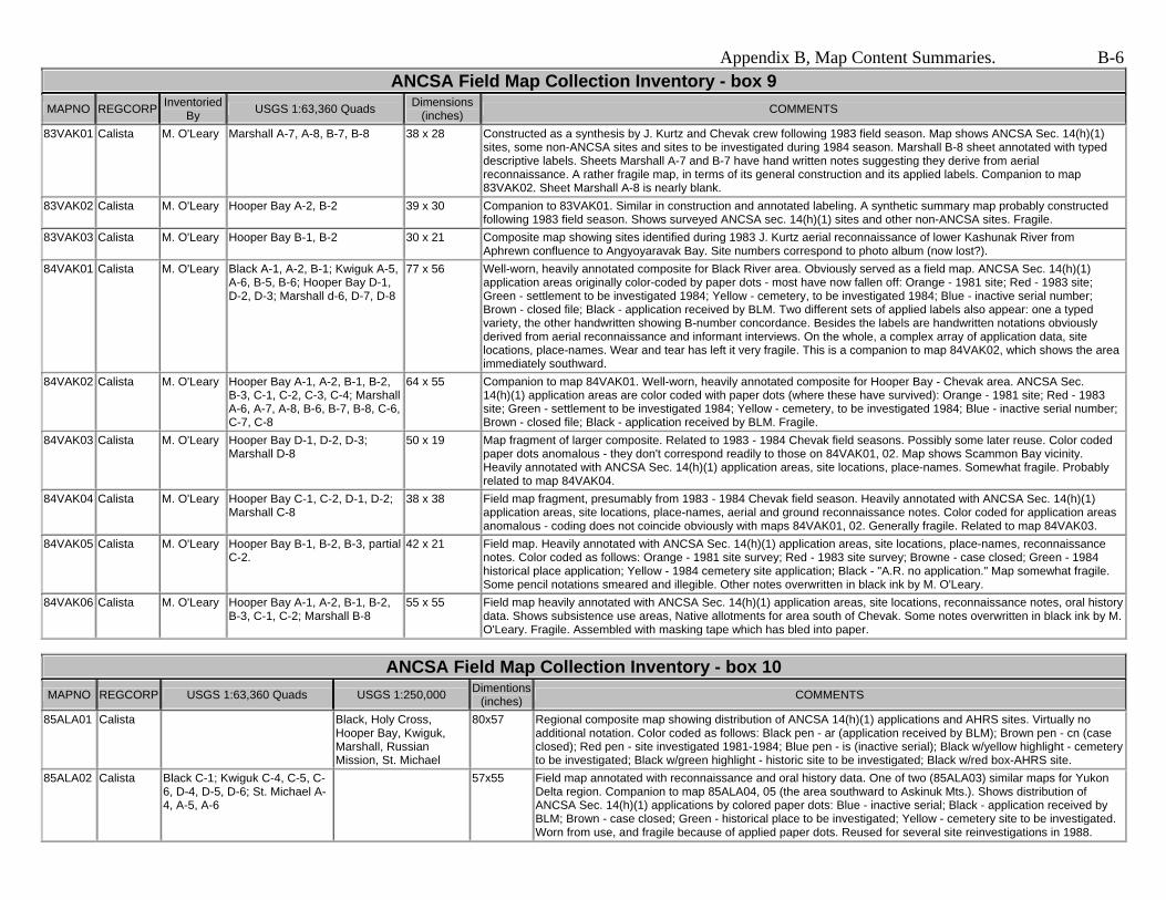
83VAK01 Calista M. O'Leary Marshall A-7, A-8, B-7, B-8 38 x 28 Constructed as a synthesis by J. Kurtz and Chevak crew following 1983 field season. Map shows ANCSA Sec. 14(h)(1) sites, some non-ANCSA sites and sites to be investigated during 1984 season. Marshall B-8 sheet annotated with typed descriptive labels. Sheets Marshall A-7 and B-7 have hand written notes suggesting they derive from aerial reconnaissance. A rather fragile map, in terms of its general construction and its applied labels. Companion to map 83VAK02. Sheet Marshall A-8 is nearly blank.
83VAK02 Calista M. O'Leary Hooper Bay A-2, B-2 39 x 30 Companion to 83VAK01. Similar in construction and annotated labeling. A synthetic summary map probably constructed following 1983 field season. Shows surveyed ANCSA sec. 14(h)(1) sites and other non-ANCSA sites. Fragile.
83VAK03 Calista M. O'Leary Hooper Bay B-1, B-2 30 x 21 Composite map showing sites identified during 1983 J. Kurtz aerial reconnaissance of lower Kashunak River from Aphrewn confluence to Angyoyaravak Bay. Site numbers correspond to photo album (now lost?).
84VAK01 Calista M. O'Leary Black A-1, A-2, B-1; Kwiguk A-5, A-6, B-5, B-6; Hooper Bay D-1, D-2, D-3; Marshall d-6, D-7, D-8
77 x 56 Well-worn, heavily annotated composite for Black River area. Obviously served as a field map. ANCSA Sec. 14(h)(1) application areas originally color-coded by paper dots - most have now fallen off: Orange - 1981 site; Red - 1983 site; Green - settlement to be investigated 1984; Yellow - cemetery, to be investigated 1984; Blue - inactive serial number; Brown - closed file; Black - application received by BLM. Two different sets of applied labels also appear: one a typed variety, the other handwritten showing B-number concordance. Besides the labels are handwritten notations obviously derived from aerial reconnaissance and informant interviews. On the whole, a complex array of application data, site locations, place-names. Wear and tear has left it very fragile. This is a companion to map 84VAK02, which shows the area immediately southward.
64 x 55 Companion to map 84VAK01. Well-worn, heavily annotated composite for Hooper Bay - Chevak area. ANCSA Sec. 14(h)(1) application areas are color coded with paper dots (where these have survived): Orange - 1981 site; Red - 1983 site; Green - settlement to be investigated 1984; Yellow - cemetery, to be investigated 1984; Blue - inactive serial number; Brown - closed file; Black - application received by BLM. Fragile.
84VAK03 Calista M. O'Leary Hooper Bay D-1, D-2, D-3; Marshall D-8
50 x 19 Map fragment of larger composite. Related to 1983 - 1984 Chevak field seasons. Possibly some later reuse. Color coded paper dots anomalous - they don't correspond readily to those on 84VAK01, 02. Map shows Scammon Bay vicinity. Heavily annotated with ANCSA Sec. 14(h)(1) application areas, site locations, place-names. Somewhat fragile. Probably related to map 84VAK04.
84VAK04 Calista M. O'Leary Hooper Bay C-1, C-2, D-1, D-2; Marshall C-8
38 x 38 Field map fragment, presumably from 1983 - 1984 Chevak field season. Heavily annotated with ANCSA Sec. 14(h)(1) application areas, site locations, place-names, aerial and ground reconnaissance notes. Color coded for application areas anomalous - coding does not coincide obviously with maps 84VAK01, 02. Generally fragile. Related to map 84VAK03.
84VAK05 Calista M. O'Leary Hooper Bay B-1, B-2, B-3, partial C-2.
42 x 21 Field map. Heavily annotated with ANCSA Sec. 14(h)(1) application areas, site locations, place-names, reconnaissance notes. Color coded as follows: Orange - 1981 site survey; Red - 1983 site survey; Browne - case closed; Green - 1984 historical place application; Yellow - 1984 cemetery site application; Black - "A.R. no application." Map somewhat fragile. Some pencil notations smeared and illegible. Other notes overwritten in black ink by M. O'Leary.
84VAK06 Calista M. O'Leary Hooper Bay A-1, A-2, B-1, B-2, B-3, C-1, C-2; Marshall B-8
55 x 55 Field map heavily annotated with ANCSA Sec. 14(h)(1) application areas, site locations, reconnaissance notes, oral history data. Shows subsistence use areas, Native allotments for area south of Chevak. Some notes overwritten in black ink by M. O'Leary. Fragile. Assembled with masking tape which has bled into paper.
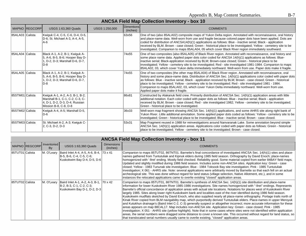
85ALA01 Calista Black, Holy Cross, Hooper Bay, Kwiguk, Marshall, Russian Mission, St. Michael
80x57 Regional composite map showing distribution of ANCSA 14(h)(1) applications and AHRS sites. Virtually no additional notation. Color coded as follows: Black pen - ar (application received by BLM); Brown pen - cn (case closed); Red pen - site investigated 1981-1984; Blue pen - is (inactive serial); Black w/yellow highlight - cemetery to be investigated; Black w/green highlight - historic site to be investigated; Black w/red box-AHRS site.
85ALA02 Calista Black C-1; Kwiguk C-4, C-5, C-6, D-4, D-5, D-6; St. Michael A-4, A-5, A-6
57x55 Field map annotated with reconnaissance and oral history data. One of two (85ALA03) similar maps for Yukon Delta region. Companion to map 85ALA04, 05 (the area southward to Askinuk Mts.). Shows distribution of ANCSA Sec. 14(h)(1) applications by colored paper dots: Blue - inactive serial; Black - application received by BLM; Brown - case closed; Green - historical place to be investigated; Yellow - cemetery site to be investigated. Worn from use, and fragile because of applied paper dots. Reused for several site reinvestigations in 1988.
85ALA03 Calista Kwiguk C-4, C-5, C-6, D-4, D-5, D-6; St. Michael A-3, A-4, A-5, A-6
63x56 One of two (also 85ALA02) composite maps of Yukon Delta region. Annotated with reconnaissance, oral history and place-name data. Well-worn from use and fragile because colored paper dots have been applied. Dots are coded for distribution of ANCSA14(h)(1) applications as follows: Blue - inactive serial; Black - application received by BLM; Brown - case closed; Green - historical place to be investigated; Yellow - cemetery site to be investigated. Companion to maps 85ALA04, 05 which cover Black River region immediately southward.
85ALA04 Calista Black A-1, A-2, B-1; Kwiguk A-5, A-6, B-5, B-6; Hooper Bay D-1, D-2, D-3; Marshall D-6, D-7, D-8
74x55 One of two composites (also 85ALA05) of Black River region. Annotated with reconnaissance, oral history and some place name data. Applied paper dots color coded for ANCSA 14(h)(1) applications as follows: Blue-inactive serial; Black-application received by BLM; Brown-case closed; Green - historical place to be investigated; Yellow - cemetery site to be investigated; Red - site investigated 1981-1984. Companion to maps 85ALA02, 03, which cover Yukon delta immediately northward. Well-worn from use. Paper dots make it fragile.
85ALA05 Calista Black A-1, A-2, B-1; Kwiguk A-5, A-6, B-5, B-6; Hooper Bay D-1, D-2, D-3; Marshall D-6, D-7, D-8
74x55 One of two composites (the other map 85ALA04) of Black River region. Annotated with reconnaissance, oral history and some place-name data. Distribution of ANCSA Sec. 14(h)(1) applications color coded with paper dots as follows: Blue - inactive serial; Black - application received by BLM; Brown - case closed; Green - historical place to be investigated; Yellow - cemetery site to be investigated; Red - site investigated 1981 - 1984. Companion to maps 85ALA02, 03, which cover Yukon Delta immediately northward. Well-worn from use. Applied paper dots make it fragile.
86x81 Constructed by Alakanuk field crew. Primarily distribution of ANCSA Sec. 14(h)(1) application areas with little additional notation. Each color coded with paper dots as follows: Blue - inactive serial; Black - application received by BLM; Brown - case closed; Red - site investigated 1982; Yellow - cemetery site to be investigated; Green - historical place to be investigated.
36x33 Well-worn map fragment showing ANCSA Sec. 14(h)(1) applications, and some AHRS site along right bank of Yukon River. Little additional annotation. Some applied paper dots coded as follows: Yellow - cemetery site to be investigated; Green - historical place to be investigated; Blue - inactive serial; Brown - case closed.
85STM03 Calista St. Michael A-2, A-3; Kwiguk C-2, C-3, D-2, D-3
53x31 Map Fragment reused in 1988 for reinvestigations around Nanvaranak Lake. Some annotation beyond simple ANCSA Sec. 14(h)(1) application areas. Applications color coded with paper dots as follows: Green - historical place to be investigated; Yellow - cemetery site to be investigated; Brown - case closed.
By USGS 1:63,360 Quads Dimensions (inches) COMMENTS
85TUT01 Calista M. O'Leary Baird Inlet A-4, A-5, A-6, B-4, B-5, B-6, C-4, C-5, C-6; Kuskokwim Bay D-4, D-5, D-6
73 x 41 Companion to maps 85TUT02, 86TNT01. Barnette's final concordance of investigated ANCSA Sec. 14(h)(1) sites and place-names gathered from Tuntutuliak and Kipnuk elders during 1985 field season. Orthography by David Enoch; place-names homogenized with '-llret' ending. Mostly field checked. Reliability good. Some material copied from earlier 84BAY field maps. Updated and slightly modified during 1986 field season. Includes some non-ANCSA sites. Application key: Green - case closed; Yellow - 1983 Tununak site investigation; Blue - 1984 Toksook Bay site investigation; Pink - 1985 Tuntutuliak investigation; X 061 - AHRS site. Note: several applications were arbitrarily moved by Barnette so that each fell on an actual archeological site. This was done without regard for land status (village selection, Native Allotment, etc.), and in some instances the relocated applications came to overlie existing "closed" application areas.
85TUT02 Calista M. O'Leary Baird Inlet A-1, A-2, A-3, B-1, B-2, B-3, C-1, C-2, C-3; Kuskokwim Bay D-1, D-2, D-3
70 x 42 Companion to maps 85TUT01, 86TNT01. Barrette's synthesis of ANCSA Sec. 14(h)(1) site distribution and place-name information for lower Kuskokwim River 1985-1986 investigations. Site names homogenized with "-llret" endings. Represents Barrette's official concordance of application areas with actual site locations. Notations for places west of Kuskokwim River largely 1985. Sites along lower right Kuskokwim bank and localities east of the river identified during 1986 field season. Kuskokwim mudflats sketched by David Enoch, who also supplied nearly all place-name orthography. Portage trails north of Kinak River copied from BLM navigability map, which purportedly derived Tuntutuliak elders. Place-names in upper Meroyuk and Kutukhun drainage's (Baird Inlet C-2, C-3) generally suspect or altogether incorrect; more accurate information for these areas appears on map 88CAL17. Map includes non-ANCSA site. Application key: Green - case closed; Pink - 1985 investigation; X 051 - AHRS site (yellow highlight). Note that in some cases where sites were not identified within application areas, the serial numbers were dragged some distance to cover a known site. This occurred without regard for land status, so that translocated serial numbers usually came to overlie existing, "closed" application areas.
By USGS 1:63,360 Quads Dimensions (inches) COMMENTS
85TUT03 Calista M. O'Leary Baird Inlet A-4, A-5, A-6, B-4, B-5, B-6; Kuskokwim Bay D-4, D-5, D-6
53 x 33 Field map compiled during 1985 season. Shows ANCSA Sec. 14(h)(1) site distribution, non-ANCSA sites and place-names. Information derived from Kipnuk elders. Orthography by David Enoch. Mostly field checked by helicopter. This map reused during 1988 (Bethel) season, when additions were made to area around Dall Lake (Baird Inlet B-4, B-5). Several sites shown on Baird Inlet A-6 were surveyed in 1984 for Toksook Bay. Water damaged.
43 x 37 Companion to maps 85TUT01, 85TUT02. Third part of Barrette's synthesis of ANCSA Sec. 14(h)(1) sites and place-names long lower Kuskokwim River. Information gathered mostly from Eek informants during 1986 field season. Few place-names.
55 x 54 Map compiled during 1986 field season. Shows distribution of ANCSA Sec. 14(h)(1) sites, applications and place-names. Most place-name data from Eek informants. Fish camp locations on sheet Bethel C-8 added in 1988. Sheet Bethel B-7 is blank. Black line along lower right Kuskokwim bank (Baird Inlet A-2) indicates river edge in 1986. Few place-names. Application key: Red - 1985 investigation; Green - case closed; 040 - AHRS site (yellow highlight).
55 x 37 Field map showing ANCSA Sec. 14(h)(1) site distribution and place-name information for left Kuskokwim River bank around Eek. Most information from Eek informants. Black lines on sheets Baird Inlet A-2, A-3 indicate river bank drawn from 1980 and 1982 aerial photos. Mostly field checked. Application key: Green - case closed; Pink - 1985 investigation (highlight); 031 - AHRS site (yellow highlight).
51 x 37 Map compiled in 1986 for limited field operation north of Nelson Island. ANCSA Sec. 14(h)(1) site distribution and place-name information mostly copied from earlier materials. Additional place-names collected in 1986. Generally poor condition. Sources: Marshall B-7, B-8 - from 84VAK; Marshall A-7, A-8 - from 83TUN01.
86TNT05 Calista M. O'Leary Hooper Bay A-1, A-2, B-1, B-2, B-3, C-1, C-2, C-3, C-4, D-1, D-2, D-3
73 x 43 Map compiled in 1986 for limited field work between Hooper Bay/Chevak and Scammon Bay. Mostly copied from earlier 84VAK material. Application code: Green - previous investigations; Red - sites to be investigated in 1986.
By USGS 1:63,360 Quads USGS 1:250,000 Dimensions (inches) COMMENTS
86PLA01 Calista M. O'Leary Goodnews A-6, A-7, A-8, B-6, B-7, B-8, C-6, C-7, C-8, D-6, D-7, D-8; Hagemeister Island C-5, C-6, C-7, D-4, d-5, D-6; Kuskokwim Bay A-1, B-1
103 x 49 Most valuable field map from 1986 Platinum camp. All known ANCSA Sec. 14(h)(1) application areas for region (including closed, rejected, relinquished, etc.) shown. Includes place-names from interview efforts at Goodnews Bay and Platinum. Extensive notations from aerial and ground reconnaissance. Also some AHRS notations sites, non-ANCSA sites, etc. Waterproofed with numerous tape repairs. This map is in poor condition. Application code: Diagonal hatch - application received by BLM; Pink - BIA report requested; Blue - inactive serial no.; Green - relinquished/rejected in part; Yellow - relinquishment requested; Orange - case closed/no conveyance.
86PLA02 Calista M. O'Leary Goodnews A-6, A-7, A-8, B-6, B-7, B-8; Hagemeister Island C-5, C-6, C-7, D-4, D-5, D-6
70 x 50 1986 field composite showing all known ANCSA Sec. 14(h)(1) applications in vicinity. This map was otherwise blank until reuse during 1990 field season, at which time place-names and various reconnaissance notations were added, primarily by M. O'Leary. Data reliability good.
89BBN01 BBNC M. O'Leary Nushagak Bay D-5, D-6 30 x 22 Heavily annotated (in pencil) field map for Kulukuk Bay and vicinity. Shows camps, trails, isolated graves. Information largely from Manokotak elder Gust Tugatuk. Well-worn.
89BBN02 BBNC M. O'Leary Hagemeister Island C-3, C-4, C-5, D-3, D-4, D-5
41 x 38 Composite for Hagemeister Island and adjacent coast. Some place-names provided by Tom Chythlook (audio tapes 89BBN006, 89BBN007); orthography by Gusty Chythlook. Also shows ANCSA Sec. 14(h)(1) application areas, site locations--including some AHRS sites and several Native Allotments.
89BBN03 BBNC M. O'Leary 46 x 33 Limited use composite of lower Nushagak Peninsula. Two place-names at southwest corner. Also shows possible site along west coast and William Johnson's Native Allotment on opposite side. A few other names from Wright and Chythlook (ADFG Technical Report No. 116).
89BBN04 BBNC M. O'Leary Nushagak Bay D-5, D-6; Hagemeister Island D-1
42 x 21 Heavily annotated field map for Kulukuk Bay area. Fabricated during 1984 field season and associated with 84TOG audio tape series. Extensive reuse during limited 1989 field operation. Many place-names provided by Henry Alakayak of Manokotak (audio tape 89BBN001). Also shows Native Allotments in vicinity. Some information copied onto field map 89BBN05.
By USGS 1:63,360 Quads USGS 1:250,000 Dimensions (inches) COMMENTS
89BBN05 BBNC M. O'Leary Nushagak Bay D-5, D-6 29 x 22 Place-names and site locations in Kulukuk Bay area provided by Manokotak elder Henry Alakayak (audio tape 89BBN001). Orthography by Molly Chythlook. Information copied extracted from field map 89BBN04. Filed with ANCSA Oral History Collection, folder 89BBN001.
89BBN06 BBNC M. O'Leary Nushagak Bay D-5, D-6 29 x 22 Field map generated by interview with Manokotak elder Gust Tugatuk (audio tapes 89BBN002, 003, 004). Place-names and oral history notations for Kulukuk Bay and vicinity. Orthography by Molly Chythlook, who also acted as interpreter. BIA interviewers Lisa Hutchinson and Mary Fogarty. Filed with ANCSA Oral History Files, folder 89BBN002.
90PLA01 Calista M. O'Leary Goodnews A-6, A-7, A-8, B-6, B-7, B-8; Hagemeister Island C-6, C-7, D-4, D-5, D-6; Kuskokwim Bay A-1, A-2
73 x 54 Primary place-name map for 1990 field work. Derived form Goodnews Bay informants. Principle interviewers M. Meade and M. Fogarty. Informant information color coded as follows: Blue - Louis Smith; Black - Charlie Kavelala; Red - John James; Green - Charlie Chingliak. Shows many place-names, some trails. Informants obviously disagreed on many individual site plots.
90PLA02 Calista M. O'Leary Goodnews A-6, A-7, B-6, B-7, B-8; Hagemeister Island C-5, C-6, C-7, D-4, D-5, D-6; Kuskokwim Bay A-1, B-1
74 x 53 Composite assembled in 1986 for initial fieldwork in Goodnews/Platinum area. Extensively reused during 1990 reinvestigations. Shows place-names (mostly copied from map 90PLA01), field reconnaissance notations. ANCSA Sec. 14(h)(1) application areas color coded as follows: Green - site surveyed in 1986; Blue - site to be investigated 1990.
90PLA03 Calista M. O'Leary Dillingham, Goodnews, Hagemeister Island, Naknek, Nushagak
61 x 40 Field map showing Bristol Bay place-names given by Louis Smith (audio tape 90PLA005, 90PLA006) of Goodnews Bay during interview with M. Meade and M. Fogarty. Other data include ANCSA Sec. 14(h)(1) application areas to be investigated in 1990, ANCSA sites examined in 1989 from Dillingham camp. Naknek quad is blank.
90PLA04 Calista M. O'Leary Goodnews B-6, B-7 30 x 22 Field map derived from on-site interviews with Goodnews Bay elder Louis Smith and BIA archeologists M. Fogarty and R. Cooper. Filed with folder 90PLA020, ANCSA Oral History Files.
By USGS 1:63,360 Quads USGS 1:250,000 Dimensions (inches) COMMENTS
87LMV01 Calista M. O'Leary Sleetmute, Lime Hills
55.5 x 23 Composite showing ANCSA Sec. 14(h)(1) application areas. Looks like D. Slaughter's field map; most notations in his hand. Some reconnaissance notes by R. Waterworth below neat line on Lime Hills quad. Sleetmute sheet shows informant residences along Kuskokwim River below Sleetmute village. Map well-used with some pencil notes faint.
87LMV02 Calista M. O'Leary Sleetmute, Lime Hills
55.5 x 23 ANCSA Sec. 14(h)(1) application areas and some AHRS sites marked. Reconnaissance and oral history notations mostly for Stoney River between Stink River and Can Creek. Place-name orthography follows J. Kari (in P. Kari 1983).
54 x 39 Shows ANCSA Sec. 14(h)(1) application areas, other sites attested by Lime Village informants. Place-names follow J. Kari (in P. Kari 1983). Original notations overwritten in black ink by M. O'Leary. Many reported sites not verified by ground reconnaissance. Sheet Sleetmute A-1 is blank.
75 x 41 Virtual copy of map 87LMV03 with some additional information. Place-names follow J. Kari (in P. Kari 1983). Most reported sites not field checked. Shows ANCSA Sec. 14(h)(1) selections.
42 x 37 Very limited notations mostly associated with application areas on Holitna River south of Sleetmute. Quads B-2, C-2, B-4, C-4 are blank.
87LMV06 Calista M. O'Leary Lake Clark, Lime Hills, Sleetmute, Taylor Mountains
57x41 Large composite. Target ANCSA application areas for 1987 season marked in pencil with yellow highlighter. Two western quadrangles most heavily annotated, presumably during interviews 87LMV006 and 87LMV013. Most of the notes are by Joe Bartolini. Some of the annotation appears to be copied from N. Mellick maps during a visit to Sleetmute.
Appendix B, Map Content Summaries. B-10
ANCSA Field Map Collection Inventory - Box 14 MAPNO Inventoried
By USGS 1:63,360 Quads COMMENTS
88CAL02 M. O'Leary, R. Drozda
Bethel A-1, A-2, A-3, A-4, B-1, B-2, B-3, B-4
Companion to maps 88CAL04, 05, 06. Place-name map compiled by L. Hutchinson from oral history interviews conducted by herself and R. Drozda in Kwethluk, Tuluksak, Akiak and Akiachak. Numbered map localities tied to attached place-name list. Data mostly field checked. Original field notations overwritten with black ink by M. O'Leary. Copies of this map provided to Kwethluk village and M. Coffing (ADFG). Xeroxed narrative and place-name list attached (88CAL_placenames.pdf). [54x37]
Place-name map compiled by R. Drozda, mostly from Akiak informants. Numbered localities tied to place-name list attached to inventory form for map 88CAL12; this map is an early or partial version of the more developed map 88CAL12. [68x36]
88CAL04 M. O'Leary, R. Drozda
Bethel A-5, A-6, A-7, A-8, B-5, B-6, B-7, B-8
Companion to maps 88CAL02, 05, 06. Place-name map compiled by L. Hutchinson and interpreter Phillip Guy. Data primarily from Kwethluk elders. Numbered localities reference list attached to 88CAL02 inventory form. Data mostly field checked. Original pencil notations overwritten with black ink. Sheets B-7, B-8 are blank. Copies of this map provided to Kwethluk village and M. Coffing (ADFG). [53x37]
88CAL05 M. O'Leary, R. Drozda
Bethel C-1, C-2, C-3, C-4, D-1, D-2, D-3, D-4
Companion to maps 88CAL02, 04, 06. Field map compiled by L. Hutchinson. Mostly field checked. Original pencil notations overwritten with black Ink. Numbered localities reference place-name list attached to inventory form 88CAL02. [52x36]
88CAL06 M. O'Leary, R. Drozda
Bethel C-5, C-6, C-7, C-8, C-5, D-6, D-7, D-8
Companion to maps 88CAL02, 04, 05. Compiled by L. Hutchinson. Numbered localities reference place-name list attached to inventory form 88CAL02. [52x36]
Compiled by P. Coiley during interview trip to the Kalskags. Numbered localities reference audio tape 88CAL081, a conversation with Sinka Williams and Stanley Nook. Some notation on sheets B-6, B-7 copied from map 82RSM01. Sheets D-3, D-7 are blank. [68x54]
Heavily annotated field map of western Akula area compiled by M. Meade, M. O'Leary and T. Krieg during conversations with elders at Nunapitchuk, Kasigluk and Napaskiak. Mostly field checked. Includes ANCSA Sec. 14(h)(1) and non-ANCSA site locations. Note that some place-names at variance with Andrews 1988. Data on sheet Marshall A-1 copied from 88CAL12. [67x55]
Large synthetic composite for lower coast, including material from maps 85TUT01, 02 and 84BAY. Shows place-names, ANCSA Sec. 14(h)(1) and non-ANCSA site locations. Numbered localities keyed to attached list by Kwigillingok school (Andrews and Ronsee 1987); copied from the original by R. Drozda. This map similar to map 88CAL18. [81x54]
Kwiguk C-5, C-6, D-5, D-6 Shows aerial reconnaissance and oral history notations for limited reinvestigation of three 1985 Alakanuk sites (AA-10026, AA-10041, AA-11763) by D. Griffin and L. Hutchinson. Letters A-l reference a 31 July 1988 taped interview with Jasper Joseph of Emmonak (tape 88CAL138). Sheet D-6 is blank. [38x34]
88CAL07 Calista M. O'Leary, R. Drozda
Bethel B-3, B-4, C-3, C-4, D-3, D-4 Field map. Shows distribution of ANCSA Sec. 14(h)(1) applications, sites, and place-names for area covered. [56x25]
Shows ANCSA Sec. 14(h)(1) applications, site locations and place-names for Tuluksak river area. Compiled by D. Griffin and D. Corbett for so-called "Tuluksak Overview." Sheet Bethel D-2 is blank. [55x38]
88CAL09 Calista M. O'Leary, R. Drozda
Bethel B-4, B-5, B-6, C-4, C-5, C-6, D-5, D-6 Field map for upper Kisaralik River area. Shows selected place-names, ANCSA Sec. 14(h)(1) applications, site locations, notes. [52x39]
88CAL10 Calista M. O'Leary, R. Drozda
Bethel D-5, D-6, D-7; Russian Mission A-5, A-6
Field map for Akiak/Kwethluk area. Shows modern Kuskokwim River fish camps, some ANCSA Sec. 14(h)(1) site locations, non-ANCSA sites, a few place-names mostly copied from map 88CAL12. [42x38.5]
Field map. Shows selected place-names, ANCSA Sec. 14(h)(1) applications and site locations, other non-ANCSA sites. A partial copy of map 82RSM01, with additional notations. [54x38]
a. Bethel D-5, D-6, D-7, D-8; Russian Mission A-5, A-6, A-7, A-8, B-5, B-7, B-8; b. Russian Mission C-5, C-6, C-7, C-8; c. Marshall A-1, A-2, B-1, B-2
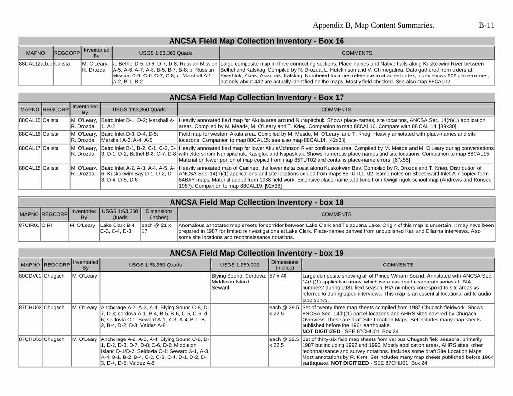
Large composite map in three connecting sections. Place-names and Native trails along Kuskokwim River between Bethel and Kalskag. Compiled by R. Drozda, L. Hutchinson and V. Chimegalrea. Data gathered from elders at Kwethluk, Akiak, Akiachak, Kalskag. Numbered localities reference to attached index; index shows 505 place-names, but only about 442 are actually identified on the maps. Mostly field checked. See also map 88CAL02.
Heavily annotated field map for Akula area around Nunapitchuk. Shows place-names, site locations, ANCSA Sec. 14(h)(1) application areas. Compiled by M. Meade, M. O'Leary and T. Krieg. Companion to map 88CAL16. Compare with 88 CAL 14. [39x30]
88CAL16 Calista M. O'Leary, R. Drozda
Baird Inlet D-3, D-4, D-5; Marshall A-3, A-4, A-5
Field map for western Akula area. Compiled by M. Meade, M. O'Leary, and T. Krieg. Heavily annotated with place-names and site locations. Companion to map 88CAL15; see also map 88CAL14. [42x38]
Heavily annotated field map for lower Akula/Johnson River confluence area. Compiled by M. Meade and M. O'Leary during conversations with elders from Nunapitchuk, Kasigluk and Napaskiak. Shows numerous place-names and site locations. Companion to map 88CAL15. Material on lower portion of map copied from map 85TUT02 and contains place-name errors. [67x55]
Heavily annotated map of Canineq, the lower delta coast along Kuskokwim Bay. Compiled by R. Drozda and T. Krieg. Distribution of ANCSA Sec. 14(h)(1) applications and site locations copied from maps 85TUT01, 02. Some notes on Sheet Baird Inlet A-7 copied form 84BAY maps. Material added from 1988 field work. Extensive place-name additions from Kwigillingok school map (Andrews and Ronsee 1987). Companion to map 88CAL19. [92x38]
87CIR01 CIRI M. O'Leary Lake Clark B-4, C-3, C-4, D-3
each @ 21 x 17
Anomalous annotated map sheets for corridor between Lake Clark and Telaquana Lake. Origin of this map is uncertain. It may have been prepared in 1987 for limited reinvestigations at Lake Clark. Place-names derived from unpublished Kari and Ellanna interviews. Also some site locations and reconnaissance notations.
By USGS 1:63,360 Quads USGS 1:250,000 Dimensions (inches) COMMENTS
80CDV01 Chugach M. O'Leary Blying Sound, Cordova, Middleton Island, Seward
57 x 40 Large composite showing all of Prince William Sound. Annotated with ANCSA Sec. 14(h)(1) application areas, which were assigned a separate series of "BIA numbers" during 1981 field season. BIA numbers correspond to site areas as referred to during taped interviews. This map is an essential locational aid to audio tape series.
Set of twenty three map sheets compiled from 1987 Chugach fieldwork. Shows ANCSA Sec. 14(h)(1) parcel locations and AHRS sites covered by Chugach Overview. These are draft Site Location Maps. Set includes many map sheets published before the 1964 earthquake. NOT DIGITIZED - SEE 87CHU01, Box 24.
Set of thirty-six field map sheets from various Chugach field seasons, primarily 1987 but including 1992 and 1993. Mostly application areas, AHRS sites, other reconnaissance and survey notations. Includes some draft Site Location Maps. Most annotations by R. Kent. Set includes many map sheets published before 1964 earthquake. NOT DIGITIZED - SEE 87CHU01, Box 24.
By USGS 1:63,360 Quads USGS 1:250,000 Dimensions (inches) COMMENTS
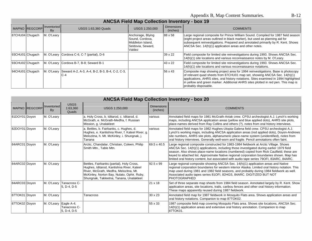
87CHU04 Chugach M. O'Leary Anchorage, Blying Sound, Cordova, Middleton Island, Seldovia, Seward, Valdez
88 x 58 Large regional composite for Prince William Sound. Compiled for 1987 field season (eight project areas outlined in black marker), but used as planning aid for subsequent reinvestigations. Prepared and annotated primarily by R. Kent. Shows ANCSA Sec. 14(h)(1) application areas and other notes.
93CHU01 Chugach M. O'Leary Cordova C-6, C-7 (partial), D-6 39 x 22 Field composite for limited site reinvestigations during 1993. Shows ANCSA Sec. 14(h)(1) site locations and various reconnaissance notes by M. O'Leary.
93CHU02 Chugach M. O'Leary Cordova B-7, B-8; Seward B-1 43 x 22 Field composite for limited site reinvestigations during 1993. Shows ANCSA Sec. 14(h)(1) site locations and various reconnaissance notations.
56 x 43 Composite map showing project area for 1994 reinvestigations. Base is photocopy of relevant quad sheets from 87CHU01 map set, showing ANCSA Sec. 14(h)(1) applications, AHRS sites, oral history notations. Sites examined in 1994 highlighted in yellow and green marker. Additional AHRS sites plotted in red pen. This map is probably disposable.
ANCSA Field Map Collection Inventory - box 20
MAPNO REGCORP Inventoried By
USGS 1:63,360 Quads
USGS 1:250,000 Dimensions (inches) COMMENTS
81DOY01 Doyon M. O'Leary a. Holy Cross, b. Iditarod, c. Iditarod, d. McGrath, e. McGrath-Medfra, f. Russian Mission, g. Unalakleet
various Annotated field maps for 1981 McGrath-Aniak crew. CPSU archeologist A.J. Lynch's working maps, including ANCSA application areas (yellow and blue applied dots), AHRS site plots, place-names derived from Ray Collins and others (?), notes from oral history interviews.
82DOY01 Doyon M. O'Leary a. Bettles, b. Fairbanks, c. Hughes, d. Hughes, e. Kantishna River, f. Kateel River, g. Melozitna, h. Mt. McKinley, i. Shungnak, j. Tanana
various Annotated field maps for 1982 Hughes-Utopia-Galena field crew. CPSU archeologist A.J. Lynch's working maps, including ANCSA application areas (red applied dots), Doyon-Andrews site numbers, AHRS site plots, alphanumeric place-name system (unidentified), notes from oral history interviews. Generally well-worn and fragile. Pencil annotations often faint.
84ARC01 Doyon M. O'Leary Arctic, Chandalar, Christian, Coleen, Philip Smith Mtn., Table Mtn.
69.5 x 40.5 Large regional composite constructed for 1983-1984 fieldwork at Arctic Village. Shows ANCSA Sec. 14(h)(1) applications, including those investigated during earlier 1979 field season. Also shows place-name locations (numbered) copied from Rick Caulfield; these are keyed to attached list. Approximate Native regional corporation boundaries shown. Map has limited oral history content, but associated with audio tape series 79OFI, 83ARC, 84ARC.
84ARC02 Doyon M. O'Leary Bettles, Fairbanks (partial), Holy Cross, Hughes, Iditarod, Kantishna River, Kateel River, McGrath, Medfra, Melozitna, Mt. McKinley, Norton Bay, Nulato, Ophir, Ruby, Shungnak, Takleetna, Tanana, Unalakleet
92.5 x 99 Large regional composite showing ANCSA Sec. 14(h)(1) application areas and Native regional corporation boundaries for western interior Alaska. Limited oral history notation. This map used during 1981 and 1982 field seasons, and probably during 1984 fieldwork as well. Associated audio tapes series 81OFI, 82HGS, 84ARC. DIGITIZED BUT NOT PHOTOGRAPHED
84ARC03 Doyon M. O'Leary Tanacross C-5, D-4, D-5
21 x 18 Set of three separate map sheets from 1984 field season. Annotated largely by R. Kent. Show application areas, site locations, trails, caribou fences and other oral history information. These maps apparently reused during 1987 fieldwork.
87TOK01 Doyon M. O'Leary Tanacross 30 x 23 Annotated field map for 1987 fieldwork in Mosquito Flats area. Shows application areas and oral history notations. Companion to map 87TOK02.
87TOK02 Doyon M. O'Leary Eagle A-4; Tanacross C-5, D-4, D-5
55 x 33 1987 composite field map covering Mosquito Flats area. Shows site locations, ANCSA Sec. 14(h)(1) application areas and extensive oral history annotation. Companion to map 87TOK01.
By USGS 1:63,360 Quads USGS 1:250,000 Dimensions (inches) COMMENTS
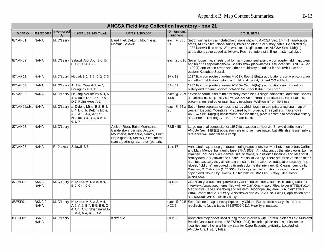
87NAN01 NANA M. O'Leary Baird Inlet, DeLong Mountains, Noatak, Selawik
each @ 30 x 23
Set of four heavily annotated field maps showing ANCSA Sec. 14(h)(1) application areas, AHRS sites, place-names, trails and other oral history notes. Generated by 1987 Noorvik field crew. Well-worn and fragile from use. ANCSA Sec. 14(h)(1) applications color coded as follows: Red - cemetery site; Blue - historical place.
each 21 x 16 Seven loose map sheets that formerly comprised a single composite field map; wear and tear has separated them. Sheets show place-names, site locations, ANCSA Sec. 14(h)(1) application areas and other oral history notations for Selawik Lake and eastern Kotzebue Sound.
87NAN03 NANA M. O'Leary Noatak B-2, B-3, C-2, C-3 39 x 31 1987 field composite showing ANCSA Sec. 14(h)(1) applications, some place-names and other oral history notations for Noatak vicinity. Sheet C-2 is blank.
87NAN04 NANA M. O'Leary Ambler River A-1, A-2; Shungnak D-1, D-2
39 x 31 1987 field composite showing ANCSA Sec. 14(h)(1) applications and limited oral history and reconnaissance notation for upper Kobuk River area.
87NAN05 NANA M. O'Leary DeLong Mountains A-3, A-4; Noatak D-3, D-4, D-5, D-7; Point Hope A-1
each @ 20 x 13.5
Seven separate sheets that formerly comprised a single composite; additional sheets apparently missing. They show ANCSA Sec. 14(h)(1) applications, site locations, place-names and other oral history notations. Well-worn from field use.
87NAN06a,b,c NANA M. O'Leary a. Delong Mtns. B-2, B-3, B-4, B-5; b. Delong Mtns. A-2, A-3, A-4, A-5; c. Noatak D-3, D-4, D-5, D-6, D-7
each @ 64 x 21
Set of three separate composite strips which together comprise a regional map of western DeLong Mountains. Prepared by R. Drozda, this synthetic map shows ANCSA Sec. 14(h)(1) applications, site locations, place-names and other oral history data. Sheets DeLong A-2, B-2, B-5 are blank.
87NAN07 NANA M. O'Leary Ambler River, Baird Mountains, Bendeleben (partial), DeLong Mountains, Kotzebue, Noatak, Point Hope (partial), Selawik, Shishmaref (partial), Shungnak, Teller (partial).
72.5 x 58 Large regional composite for 1987 field season at Noorvik. Shows distribution of ANCSA Sec. 14(h)(1) application areas to be investigated but little else. Essentially a reference wall map for field camp.
87NAN08 NANA R. Drozda Selawik B-6 11 x 17 Annotated map sheep generated during taped interview with Kotzebue elders Collins and Mary Mendenhall (audio tape 87NAN063). Annotations by the interviewer, Lonnie Brantley. Includes place-names, site locations, subsistence localities and other oral history data for Baldwin and Choris Peninsula vicinity. There are three versions of the map but basically they all contain the same information; A. reduced photocopy map labeled "old one" annotated by Brantley during the interview; B. Cleaner version by Brantley; C. Full-scale (1:63,360) photocopy with information from maps A and B copied and labeled by Drozda. On file with ANCSA Oral History Files, folder 87NAN063.
87TEL12 BSNC / NANA
M. O'Leary Kotzebue A-4, A-5, B-4, B-5, C-4, C-5
45 x 29 Oral history annotations provided by Shishmaref elder Gideon Barr during untaped interview. Associated notes filed with ANCSA Oral History Files, folder 87TEL-IN014. Map shows Cape Espenberg and western Goodhope Bay area. BIA interviewers Carol Brandt and M. O'Leary. Also shows one ANCSA Sec. 14(h)(1) application area and several AHRS sites in vicinity.
Set of sixteen map sheets prepared by Gideon Barr to accompany his dictated recollections (audio tapes 88ESP005-011). Heavily annotated.
88ESP02 BSNC / NANA
M. O'Leary Kotzebue 30 x 23 Annotated map sheet used during taped interview with Kotzebue elders Levi Mills and Bessie Cross (audio tapes 88ESP001-004). Includes place-names, subsistence localities and other oral history data for Cape Espenberg vicinity. Located with ANCSA Oral History Files.
By USGS 1:63,360 Quads USGS 1:250,000 Dimensions (inches) COMMENTS
88ESP03 BSNC / NANA
M. O'Leary Kotzebue C-4, C-5 32 x 22 Annotated composite generated during taped interviews with Kotzebue elders Levi Mills and Bessie Cross (audio tapes 88ESP001-004). Includes place-names, site locations, and subsistence localities in immediate vicinity of Cape Espenberg. Map located with ANCSA Oral History Files.
88NAN01 BSNC / NANA
M. O'Leary Selawik C-4, C-5, C-6 each @ 29.5 x 22.5
Three loose, contiguous map sheets showing oral history and site location notes for lower Kobuk River distributaries. Prepared by M. Fogarty during taped interview with elder Helen Kagoona (audio tape 88NAN001). On file with ANCSA Oral History Files, folder 88NAN001.
79OSI01 Sealaska M. O'Leary Bradfield Canal, Craig, Dixon Entrance, Juneau, Ketchikan, Mt. Fairweather, Port Alexander, Prince Rupert, Skagway, Sumdum, Taku River, Yakutat
each @ 30 x 25
Set of twelve quad sheets for southeast Alaska showing ANCSA Sec. 14(h)(1) application areas but little else. Compiled by BIA. Most locations have no identification note or number. These are probably disposable - superseded by atlas. NOT DIGITIZED.
ANCSA Field Map Collection Inventory - box 23 MAPNO Inventoried
By USGS 1:63,360 Quads Dimensions (inches) COMMENTS
81 x 56 Composite Nunivak Island map assembled and annotated by Ted Krieg prior to 1991 reinvestigations. Shows all ANCSA sites (BLM numbers only) investigated during 1986 field season. Brittle.
75 x 57 Composite Nunivak Island map. Place-name compilation by K. Pratt and R. Drozda. Evidently based on 1986 fieldwork but date of map uncertain. Tape has largely failed, leaving many loose quad sheets. Tape removed, and sheets reassembled into four sections by RD, 5/6/05, prior to digitization.
18 x 22 each Quad sheets for Nunivak Island individually annotated by K. Pratt to show man-made rock features on island interior. Sites were identified during aerial reconnaissance and oral history interviews ca. 1986, 1991. Annotations color coded in pen as follows: Black are estimated minimum numbers and locations of stone shelters; Blue are estimated minimum number of cairns; Red are number and location of reported or possible graves.
Set of thirty two map sheets compiled by W. Dotter for 1987 Chugach field season. Heavily annotated with oral history, site locations, AHRS sites, ANCSA Sec. 14(h)(1) application areas. Set includes many map sheets predating 1964 earthquake. Sheets keyed to attached informant list.
82RSM02 Calista 25 Drozda ------------ -------- 35" x 24" Folder 8 - Native Sketch Map by Joshua Phillip of Tuluksak, Alaska showing historical places and place names written in old Yup'ik (Moravian) orthography in the vicinity of USGS Pikmiktalik River and Israthorak Creek, Alaska. Includes some English and Yup’ik annotations by Anna Phillip, Joshua’s daughter. Date: 1982. Material: heavy cardboard, pencil. Includes descriptive note on reverse side by Drozda. AHP and ANCSA 14(h)(1) Collection, UAF Archives, Series 1:09 Folder 8.
54 x 37 Large regional composite for northern Alaska Peninsula. AHRS sites and ANCSA Sec. 14(h)(1) applications shown. Limited oral history notations for Egegik and Becharof Lake from Egegik informants during taped interviews conducted by R. Kent and T. Krieg (audio tapes 90 KON001-009). Karluk, Mt. Katmai and Trinity Islands sheets blank.
42 x 38 Composite map showing eastern Becharof Lake and "Island Arm." Oral history notations from Egegik elders during interviews conducted by R. Kent and T. Krieg (audio tapes 90KON001-009). Mostly applicable to ANCSA Sec. 14(h)(1) applications AA-11774, AA-11775. Located with ANCSA Oral History Files.
90KON03 Koniag M. O'Leary Karluk, Mt. Katmai, Naknek, Ugashik
40 x 38 Large regional composite for northern Alaska Peninsula. Oral history notations from untaped interview with Egegik elder Nick Abalama. Interview conducted by Marie Meade and M. O'Leary. Mostly place-names and site locations for Egegik and Ugashik Rivers. Also shows BBNC ANCSA Sec. 14(h)(1) applications for historic oil well sites between Shelikof Strait and eastern Becharof Lake. Filed with ANCSA Oral History Files, folder 90KON-IN001.
34 x 25 Photocopy of map 90KON02 with additional oral history information and place-names supplied by Egegik elder Nick Abalama. From untaped interview with M. Meade and M. O'Leary. Located in folder 90KON-IN001, ANCSA Oral History Files.
90KON05 Koniag M. O'Leary Karluk, Mt. Katmai, Naknek, Ugashik
48 x 39 Large regional composite for northern Alaska Peninsula. Place-names, site locations and other oral history notations supplied by Egegik elder Nick Abalama during lengthy taped interview with M. Meade and R. Cooper (audio tapes 90KON010-012). Place-name orthography by M. Meade. Red pencil numbers by R. Cooper keyed to his handwritten notes. Located in folder 90KON010, ANCSA Oral History Files. Mt. Katmai quad is blank.
91AKP01 Koniag M. O'Leary Bristol Bay, Chignik, Karluk (partial), Stepovak Bay, Sutwik Island, Ugashik
57 x 53 Large regional composite for middle Alaska Peninsula. Originally constructed in 1987 as companion to map 87KOD01. Reused subsequently. Includes regional corporation boundaries, ANCSA Sec. 14(h)(1) applications and site locations, selected AHRS sites. Coded as follows: Yellow - closed, rejected; Pink - closed, relinquished; Blue/no color - retained after 1987 relinquishments; Green - isolated AHRS site. Heavily annotated in 1991 during series of untaped interviews at Perryville and Chignik by J. Bartolini and M. O'Leary. Filed with 91AKP-IN series folders, ANCSA Oral History Files.
91AKP02 Koniag M. O'Leary Chignik B-2 22 x 18 Annotated map sheet generated during series of untaped interviews with Chignik elders in 1991. Interviews conducted by J. Bartolini and M. O'Leary. Primarily site locations and oral history data for west Chignik Bay and Chignik Lagoon.
By USGS 1:63,360 Quads USGS 1:250,000 Dimensions (inches) COMMENTS
79OSI02 Sealaska M. O'Leary a. Petersburg, b. Port Alexander, c. Sitka
30 x 23 each CPSU project maps for 1979 field season. Named and numbered application areas in blue pen. Some additional blue pen annotation based on Swanton (?). Limited oral history and survey annotation by A.J. Lynch.
79OSI03 Sealaska M. O'Leary Port Alexander B-1, D-1, D-2; Sitka A-2, B-2
CPSU project maps for 1979 field season. ANCSA applications indicated by yellow applied dots. Site names and BLM numbers in blue pen, similar to 79OSI02. Little other annotation. A.J. Lynch maps. NOT DIGITIZED.
80SEA01 Sealaska M. O'Leary NOAA chart 16016, Dixon Entrance to Cape St. Elias, 1:969,756 scale. CPSU archeologist A.J. Lynch project map. ANCSA sites south of Kupreanof Island marked in pen. Little other annotation. NOT DIGITIZED.
02SEA01 Sealaska M. O'Leary Port Alexander C-4 18 x 22 Single annotated quad sheet derived from untaped interview with Doug Didrickson of Sitka. Interview and annotation by M. O'Leary.
------ 55" x 56" Composite map composed of 12 USGS quadrangle sheets, 1:63,360. Handwritten annotations and taped labels predominantly Dena'ina place names and some subsistence resource information. Compiled by James Kari and Priscilla Russell Kari. n.d. ca. 1983. Original map in possession of J. Kari.
ANCSA Field Map Collection Inventory - box 29 MAPNO REGCO
30" X 41" Nunivak Island-Cape Mendenhall 1:250,000 scale composite map with preliminary site locations and annotations, n.d. ca. 1975-76. Compiler: Susan Hansen (assumed). AHP and ANCSA 14(h)(1) Collection, UAF Archives, Series 1:09 Folder 7.
82RSM04 Calista Drozda Russian Mission
30" X 23" Field map showing site locations, place names, oral history reconnaissance notes for 1982 investigations between the Yukon and Kuskokwim Rivers. Compiled by Drozda. AHP and ANCSA 14(h)(1) Collection, UAF Archives, Series 1:09 Folder 12.
--------------- 82" X 56" Field composite map for all Nunivak Island, compiled from 14(h)(1) investigations, oral history interviews, field reconnaissance and place names recorded by Drozda and Pratt in 1986 - 1991; later annotations by Drozda in association with Nunivak Place Name Project - Phase I (1994). Preliminary map to 94NUN01. Drozda Collection.
18" X 22" 15 map sheets. All but Nunivak Island (A-2) are laminated with stick-on labels (place names, numbers), NI(A-2) is a color photocopy of original laminated map that was lost. Maps show comprehensive place name collection for NPNP phase I (1994). Prepared by Drozda for Nunivak IRA Council with funding from NPS Historic Preservation Funds. Preliminary Cup'ig (Nunivak Dialect) orthography by E. Irene Reed and Dorothy Kiokun. Drozda Collection.
98BSN01 BSNC Drozda Norton Bay C-4 and D-4
18" X 39" Folder 11 - Norton Bay composite map (Norton Bay C-4 and D-4) with 14(h)(1) sites, place names and annotations. Donated by Wendy Arundale, July 1998. Map date ca. 1980. AHP and ANCSA 14(h)(1) Collection, UAF Archives, Series 1:09 Folder 11.
ANCSA Field Map Collection Inventory - box 30 MAPNO REGCO
RP Inventoried
By USGS 1:250,000 Dimensions (inches) COMMENTS
MINCH01 Doyon Drozda Mt. McKinley, Kantishna River, Talkeetna
30x30 "Minchumina Area Resource Use." Compiled by Richard H. Bishop, 1978. Blueline. Supplement map to "Subsistence Resource Use in the Proposed North Addidion to Mt. McKinley National Park. AHP CPSU Occasional Paper No. 17, December 1978. Photocopy of Talkeetna section (not digitized) added 8/18/05 from Rasmuson Library shelf copy, Call # f912 M23 B57. Shelf copy Blueline is reduced, thus lower quality. AHP and ANCSA 14(h)(1) Collection, UAF Archives, Series 1:09 Folder 13.
80ADFG01 Doyon Drozda Table Mountain, Coleen, Arctic, Christian, Philip Smith Mountains, Chandalar, Fort Yukon, Circle
66 x 44 "Gwich'in Athabaskan Place Names for Arctic Village, Alaska." Blueline composite. 226 numbered locations with side bar Gwich'in name and English translation. Map 1 Supplement to Gwich'in Athabaskan Place Names of the Upper Yukon-Porcupine Region, Alaska: A Preliminary Report. ADF&G Technical Paper Number 83. August 1983. Map compiled by R. A. Caulfield, Subsistence Division, ADF&G, Nov. 1980. Map may be rare. Four other maps in series not included in UAF Collection. Rasmuson Library copy of Technical paper 83 is missing. AHP and ANCSA 14(h)(1) Collection, UAF Archives, Series 1:09 Folder 14.
82ADFG01 Doyon Drozda 54x37 "Gwich'in Athabaskan Place Names for Birch Creek, Alaska." Blueline composite.52 numbered locations with side bar Gwich'in name and English translation. Map 2 Supplement to Gwich'in Athabaskan Place Names of the Upper Yukon-Porcupine Region, Alaska: A Preliminary Report. ADF&G Technical Paper Number 83. August 1983. Map compiled by R. A. Caulfield, Subsistence Division, ADF&G, February 1982. Map may be rare. Four other maps in series not included in UAF Collections. AHP and ANCSA 14(h)(1) Collection, UAF Archives, Series 1:09 Folder 14.
LMV02JK Calista Drozda 31x30 "Maps for the Lime Village Study, Dena'ina Place Names, Map 3." Blueline Composite. 278 Numbered locations with Dena'ina place names and English translations. From P. R. Kari 1983, Land Use and Economy of Lime Village, ADF&G Technical Paper No. 80. UAF has fiche copy only. Map provided by and in J. Kari private collection.
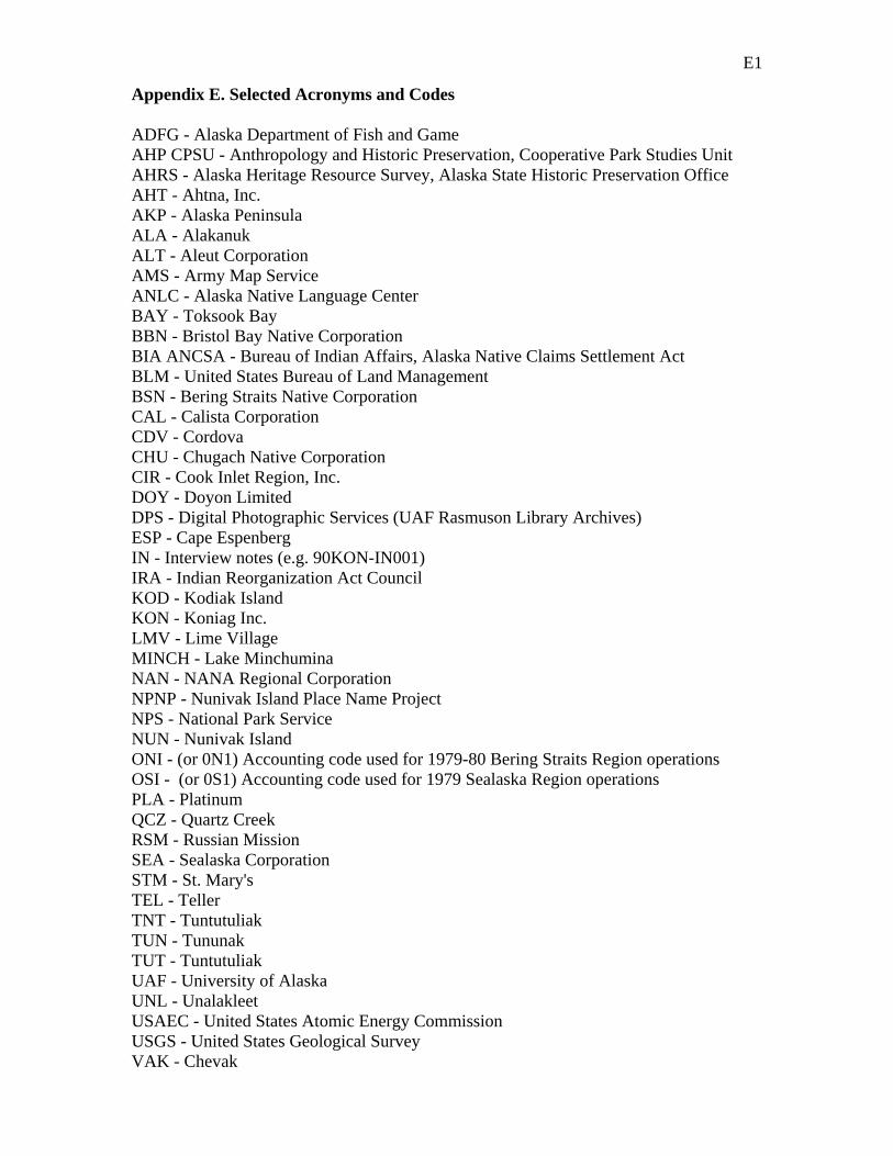
E1
Appendix E. Selected Acronyms and Codes ADFG - Alaska Department of Fish and Game AHP CPSU - Anthropology and Historic Preservation, Cooperative Park Studies Unit AHRS - Alaska Heritage Resource Survey, Alaska State Historic Preservation Office AHT - Ahtna, Inc. AKP - Alaska Peninsula ALA - Alakanuk ALT - Aleut Corporation AMS - Army Map Service ANLC - Alaska Native Language Center BAY - Toksook Bay BBN - Bristol Bay Native Corporation BIA ANCSA - Bureau of Indian Affairs, Alaska Native Claims Settlement Act BLM - United States Bureau of Land Management BSN - Bering Straits Native Corporation CAL - Calista Corporation CDV - Cordova CHU - Chugach Native Corporation CIR - Cook Inlet Region, Inc. DOY - Doyon Limited DPS - Digital Photographic Services (UAF Rasmuson Library Archives) ESP - Cape Espenberg IN - Interview notes (e.g. 90KON-IN001) IRA - Indian Reorganization Act Council KOD - Kodiak Island KON - Koniag Inc. LMV - Lime Village MINCH - Lake Minchumina NAN - NANA Regional Corporation NPNP - Nunivak Island Place Name Project NPS - National Park Service NUN - Nunivak Island ONI - (or 0N1) Accounting code used for 1979-80 Bering Straits Region operations OSI - (or 0S1) Accounting code used for 1979 Sealaska Region operations PLA - Platinum QCZ - Quartz Creek RSM - Russian Mission SEA - Sealaska Corporation STM - St. Mary's TEL - Teller TNT - Tuntutuliak TUN - Tununak TUT - Tuntutuliak UAF - University of Alaska UNL - Unalakleet USAEC - United States Atomic Energy Commission USGS - United States Geological Survey VAK - Chevak
rmdrozda
Typewritten Text
rmdrozda
Typewritten Text
Appendix F 1 Map Location Quick Reference (some maps may be applicable or relevant to more than one region). Regional Corporation Box / Disk Number Ahtna 1 Aleut 2, 3, 4, 5 Bering Straits (BSNC) 6, 29 Bristol Bay (BBNC) 12 Calista 7, 8, 9, 10, 11, 12, 13, 14, 15, 16, 17, 23, 28, 29, 30 Chugach 19, 24 Cook Inlet (CIRI) 18 Doyon 20, 30 Koniag 2, 26 Northwest Arctic (NANA) 21 Sealaska 22, 27 Box / Disk Number Corporation Years Comment