Kelvin C.P. Wang Professor University of Arkansas [email protected][email protected]University of Arkansas 4190 Bell Engineering Center Fayetteville, AR 72701 479.575.6026 – Office 479.575.7168 - Fax Practices and Technologies in Hazardous Material Transportation and Security DHS 1107 Prepared for Mack-Blackwell Rural Transportation Center National Transportation Security Center of Excellence University of Arkansas ACKNOWLEDGEMENT This material is based upon work supported by the U.S. Department of Homeland Security under Grant Award Number 2008-ST-061-TS003. DISCLAIMER The views and conclusions contained in this document are those of the authors and should not be interpreted as necessarily representing the official policies, either expressed or implied, of the U.S. Department of Homeland Security.
University of Arkansas 4190 Bell Engineering Center Fayetteville, AR 72701 479.575.6026 – Office 479.575.7168 - Fax
Practices and Technologies in Hazardous Material Transportation and Security DHS 1107
Prepared for Mack-Blackwell Rural Transportation Center
National Transportation Security Center of Excellence University of Arkansas
ACKNOWLEDGEMENT This material is based upon work supported by the U.S. Department of Homeland Security under Grant Award Number 2008-ST-061-TS003. DISCLAIMER The views and conclusions contained in this document are those of the authors and should not be interpreted as necessarily representing the official policies, either expressed or implied, of the U.S. Department of Homeland Security.
1Practices and Technologies in Hazardous Material Transportation and Security Title
Executive Summary
The University of Arkansas (UA) team is
responsible for investigating practices of
hazardous material transportation in the private
sector. The UA team is a sub‐contractor to the
project “Petrochemical Transportation Security,
Development of an Interactive Petrochemical
Incident Location System (PILS), DH‐08‐ST‐061‐004” with the PI institution being Texas
Southern University National Transportation Security Center of Excellence. This Report
presents synthesis of research activities in the relevant area and overview of
technologies used by J.B. Hunt Transport.
2Practices and Technologies in Hazardous Material Transportation and Security Title
Contents
Executive Summary 1
Introduction 5
Introduction 5
Case Studies 5
SERRI Project at the University of Kentucky 5
Transportation Routing Analysis Geographic Information System (TRAGIS) by Oak Ridge
National Laboratory 8
GIS‐Based HAZMAT Management System by University of Alabama 9
Singapore's Development of a HAZMAT Route Planning System 10
Transportation Security Practices of J.B. Hunt Transport 13
Conclusion 14
References 17
3Practices and Technologies in Hazardous Material Transportation and Security Title
Department of Homeland Security Supplemental Funding Opportunity DH‐08‐ST‐061‐004
Carol Abel Lewis, Ph.D., Principal Lei Yu, Ph.D., Co‐Principal Carroll G. Robinson, J.D. Co‐Principal Oscar Criner Ph.D., Team Coordinator 3100 Cleburne Houston, Texas 77004 713‐313‐7924 [email protected][email protected][email protected]
4Practices and Technologies in Hazardous Material Transportation and Security Title
Practices and Technologies in Hazardous Material Transportation and Security
Final Report
Kelvin C.P. Wang
Department of Civil Engineering 4190 Bell Engineering University of Arkansas Fayetteville, AR 72701
Email: [email protected], Phone: 479‐575‐8425, Fax: 479‐575‐7168 November 23, 2011
Abstract:
The University of Arkansas (UA) team is responsible for investigating practices of
hazardous material transportation in the private sector. The UA team is a sub‐contractor
to the project “Petrochemical Transportation Security, Development of an Interactive
Petrochemical Incident Location System (PILS), DH‐08‐ST‐061‐004” with the PI
institution being Texas Southern University National Transportation Security Center of
Excellence. This Interim Report presents synthesis of research activities in the relevant
area and overview of technologies used by J.B. Hunt Transport.
5Practices and Technologies in Hazardous Material Transportation and Security Title
Introduction Identifying hazardous material (HAZMAT) transportation gained momentum in the wake of the
terrorist attacks of September 11, 2001. According to the Bureau of Transportation Statistics, in
2004 there were 11 million trucks making shipments into America from Canada and Mexico and
trade with the two countries accounts for 31.1% of the total U.S. trade (1). The scope of this
project focuses on hazardous material transportation and security. Therefore, the work
conducted by the University of Arkansas team is on private practices of transporting hazardous
materials. Businesses have a different focus on HAZMAT transport versus government entities;
they are concerned with the minimization of risk and cost.
The need to monitor the transport of hazardous goods to minimize them as potential targets for
terrorists is highlighted by the 10 year (1999 to 2008) Hazardous Materials Incident Report of
the Pipeline and Hazardous Materials Safety Administration of the U.S. Department of
Transportation (2). U.S. Department of Transportation defines hazardous materials as belonging
to one of nine hazard classes: Class 1, Explosives; Class 2, Gases; Class 3, Flammable liquids;
Class 4, Flammable solids; Class 5, Oxidizers and Organic Peroxides; Class 6, Toxic Materials and
Infectious Substances; Class 7, Radioactive Materials; Class 8, Corrosive Materials; and Class 9,
Miscellaneous Dangerous Goods (3).
Aspects of the risk in transportation of HAZMAT might be divided into two factors: 1) the
likelihood of various accidents occurring. 2) The damage caused by an accident that does occur
(4). The following case studies incorporate these factors into their HAZMAT systems. This
report first presents several case studies on using technology for monitoring and managing
transportation of hazardous materials. The report then discusses technologies of space based
tracking technology for nationwide trucking movements used by J.H. Hunt Transport. It is
anticipated that many firms with large size logistic and supply chain operations may employ
similar technologies for monitoring freight movements.
Case Studies
SERRI Project at the University of Kentucky
At the end of 2008, the University of Kentucky researchers completed a project on hazardous
material transportation with DHS funding via the Southeast Region Research Initiative (SERRI)
(5). There are over 800,000 hazardous materials (hazmat) shipments over the nation’s roads
each day. According to the U.S. Department of Homeland Security (DHS), terrorist activity
related to the transportation of hazardous materials represents a significant threat to public
safety and the nation’s critical infrastructure. Specifically, the federal government has pointed to
the government’s inability to track hazmat shipments on a real‐time basis as a significant
security vulnerability.
In 2004, the U.S. Federal Motor Carrier Safety Administration (FMCSA) completed a study to
determine if “smart truck” technology such as GPS tracking, wireless modems, panic buttons,
and on‐board computers could be used to enhance hazmat shipment security. The FMCSA study
6Practices and Technologies in Hazardous Material Transportation and Security Title
concluded that smart truck technology will be highly effective in protecting hazmat shipments
from terrorists. The FMCSA study also concluded that smart truck technology deployment will
produce a huge security benefit and an overwhelmingly positive return on investment for
hazmat carriers.
The FMCSA study led to the U.S. Transportation Security Administration’s (TSA) Hazmat Truck
Security Pilot. This congressionally mandated pilot program was undertaken to demonstrate if a
hazmat truck tracking center was feasible from a technology and systems perspective and to
determine if existing truck tracking systems can interface with government intelligence centers
and first responders. The Hazmat Truck Security Pilot demonstrated that a hazmat truck tracking
center is feasible and in August 2007, Congress enacted legislation that directs TSA to develop a
program ‐ consistent with the Hazmat Truck Security Pilot ‐ to facilitate the tracking of motor
carrier shipments of security‐sensitive materials.
In a different initiative, the U.S. Environmental Protection Agency is interested in implementing
an electronic manifest rule that would allow companies to use electronic manifests instead of
paper manifests for their hazardous waste shipments. Hazardous waste is a small subset of the
much larger hazmat universe and the transportation of hazardous waste is co‐regulated by EPA
and the U.S. Department of Transportation. EPA and DOT regulations recognize EPA’s hazardous
waste manifest as satisfying DOT’s hazmat shipping paper requirement. EPA estimates that the
use of electronic manifests instead of paper manifests has the potential to generate over $300
million/year in cost savings. EPA has expressed strong interest in using a public/private
partnership to build a national hazardous waste electronic manifest processing center. Under
this approach, a private party would build and operate the processing center at its own expense
and collect a transaction fee for processing electronic manifests.
The Kentucky Transportation Center (KTC) of the University of Kentucky led a project funded by
DHS via the Southeast Region Research Initiative (SERRI) to evaluate TSA and EPA needs. SERRI is
managed by BWXT Y‐12 of Oak Ridge, TN. KTC project partners for the SERRI project were:
Morehead State University (Morehead, KY); Coldstream Digital LLC (Lexington, KY; Great Falls,
VA); General Dynamics Advanced Information Systems (Buffalo, NY), and ThoughtWorks Inc.
(Chicago, IL).
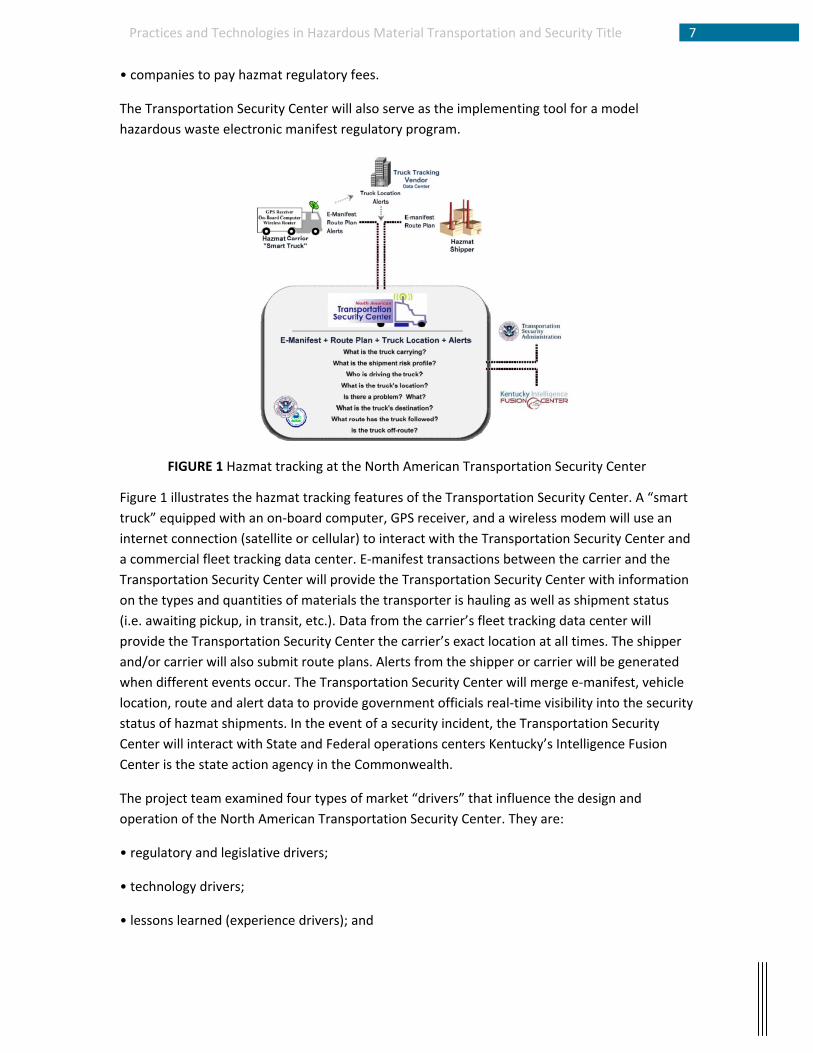
KTC’s SERRI project began August, 2007 and was completed October 2008. The project was
designed to assess the feasibility of establishing the North American Transportation Security
Center in Kentucky. The Transportation Security Center, as envisioned by the KTC project team,
will serve as the implementing tool for a model hazmat regulatory program in Kentucky that will
require:
• high‐risk hazmat transporters to install “smart truck” technology on their vehicles;
• shippers and carriers to send electronic manifests and electronic route plans to the
Transportation Security Center;
• carriers to report vehicle location and alerts to the Transportation Security Center (real‐time
XML data feed); and
7Practices and Technologies in Hazardous Material Transportation and Security Title
• companies to pay hazmat regulatory fees.
The Transportation Security Center will also serve as the implementing tool for a model
WIPP; and 7) Other. These choices control how the impedance of the route is calculated. The
goal is to calculate the route with the least impedance. The final step is choosing the population
buffer along the specified route. The population buffer can be set using the values of 400, 800,
or 2500 meters. The default value is 800 meters. WebTRAGIS uses the values to calculate the
population density around the route. Once the criteria are input the route can be calculated.
Alternative routes are calculated in WebTRAGIS to compare impedance values with the original
route and are assigned a penalty value ranging from 1 to 100. This allows the user to compare
multiple routes.
GIS‐Based HAZMAT Management System by University of Alabama
The University of Alabama developed a GIS‐based hazardous waste transport system (HWTS)
that uses probabilistic risk assessment which is the product of the probability of occurrence of a
hazardous waste accident and the consequences of that accident (4). The goal is to calculate
the route that would cause the least amount of damage should a hazardous waste incident
occur. Each route segment is scored by taking the vulnerability of the facilities multiplied by the
risk of the road segment. HWTS identifies high‐impact areas subject to a hazardous waste
accident such as schools, hospitals, retirement homes, day care centers vulnerable to a
hazardous waste accident. In route selection, the user defines an origin and a destination. The
level of impact of a hazardous waste accident on each road segment is assigned a value and is
represented by rings surrounding the facilities in HWTS. Facilities located along the road
segments are given a score based on the vulnerability of the facilities multiplied by the risk of
the road segment.
The researchers from the University of Alabama conducted their case study using the city of
Birmingham as their example and used 1995 TIGER files from the U.S. Census Bureau. During
the case study the routes selected applied to all vehicles not just truck routes. In the case study
a waste origin site and a waste destination site are picked by a user (shipment origin and
destination). After picking the points, the program generates the shortest route without regard
to the impact of hazardous accident. In their study, the distance of the route is 10.54 miles and
a score of 38.91. A new route is created by HWTS that takes into account schools located near
the route and generates a ring of impact around each school. The proximity of the ring to the
road determines the hazardous waste impact value and the roadway distance. Minimizing
hazardous waste impact, the new route distance is 11.68 miles with a score of 32.40. From the
case study the researchers show that the longer route is safer than the shorter route. Future
research includes determining the safest route with the consideration of other facilities such as
hospitals and day care centers to the Birmingham case study and providing routes based on the
type of shipment, i.e., liquid or gas, corrosive or toxic and so on.
10Practices and Technologies in Hazardous Material Transportation and Security Title
Singapore's Development of a HAZMAT Route Planning System
Singapore is a densely populated area and serves as a major hub for the transportation of petrochemicals to Southeast Asia. It is the world’s third largest oil‐refining center, behind Rotterdam and Houston (7). The effects of a hazardous waste incident would be catastrophic. The transportation of hazardous materials is jointly regulated by Singapore’s National Environment Agency’s Pollution Control Department and Civil Defense Force. They determine the safest route, including origin and destination, of the vehicles but do not present alternate routes or provide reasons to why the route was chosen. Researchers at the University of Singapore wanted to develop a hazardous materials system that addresses the security, the cost, and the exposure factors. They use ArcGIS to visually identify the routes and assign a cost to the routes based on the level of safety using a Genetic Algorithm (GA).
The researchers chose a 3 km by 3 km area to test their system and nine routes: three main
routes compared to six alternative routes (Figure 2). Their routes are based on five criteria: 1)
exposure; 2) socio‐economic impact; 3) risks of hijack; 4) traffic conditions; and 5) emergency
response. The first criteria, exposure, the researchers created in ArcGIS a 0.8 km buffer zone
along all the routes based on FHWA guidelines for combustible hazardous materials. Socio‐
economic impact refers to the how the damages to the surrounding infrastructure affects the
residents socially and financially in the 0.8 km zone. The third criteria, risks of hijack, are areas
with little or no covering. They are given a higher score as well as areas with small populations.
For the criteria of traffic conditions, traffic density, accident frequency, flow, average speed, and
number of signalized intersections are considered (2). Higher costs are assigned to congested
routes, signalized intersections. For the last criteria, emergency response, routes that are
located near hospitals, fire departments, military bases and so on are given a lower cost than
routes that are farther away from the emergency response departments.
FIGURE 2 The 3 km by 3 km test area with the 9 routes in Singapore
The criteria are further divided by factors which are given a score ranging from as low as 1 to as
high as 7 depending on the number of factors under the criteria. For example, using the
11Practices and Technologies in Hazardous Material Transportation and Security Title
emergency response criteria, the scores relate to the distance of emergency response facilities
to the route with 1 being close and 5 being far. Table 1 lists the factors for each of the criteria.
TABLE 1
The project uses a GA to assign a weight to each criterion with the goal of minimizing the
generalized cost (2). The GA process is similar to natural selection. Rather than representing a
phenotype such as eye color, the “children” in the GA process represent solutions. Likewise the
fitness of the solutions represents more correct solutions rather than how it successful it will be
at reproducing. The GA creates a population of strings which represent solutions to the
problem. New populations are created by ranking the candidate solutions. First populations are
created based on the generalized cost equation. The costs are evaluated and mates are
selected. Next the populations reproduce and mutations occur. With each successive
reproduction the GA’s answer becomes closer to the solution, much like an iterative process.
In analyzing the results the researchers first compared the weights of each of the five criteria
with the nine routes before comparing each routes’ generalized cost equation. Based on the
weights determined for the five criteria, the results suggest that the main considerations are
exposure and socio‐economic impact (2). The researchers state that the considerations have
changed since September 11, 2001 with more emphasis needed on hijack and emergency
response criteria. Future research includes investigating the outcome of adding different
weights to specified criteria in the GA.
GIS Spill Management Information System by a partnership between USACE and Vanderbilt
The Spill Management Information System (SMIS) was designed to overcome many of the
communications and coordination challenges generated following a spill incident by providing
responders with access to uniform information comprised of real‐time incident information and
12Practices and Technologies in Hazardous Material Transportation and Security Title
maps, contaminant transport models, chemical response data, areal displays of contaminant
procession, and locations of sensitive receptors (8). The project goal was to develop a SMIS,
coupling geographic information systems (GIS) with advanced water quality and air dispersion
models to provide real‐time information to emergency responders following an incident
involving hazardous materials.
SMIS models an accident in the air and in the water. Air contaminant modeling is accomplished
by the Computer‐Aided Management of Emergency Operations software and the Areal
Locations of Hazardous Atmospheres air dispersion model. The water quality monitoring is
accomplished by the USACE CE‐QUAL‐W2 program. Output data from both of the programs are
viewed in ArcView GIS providing the user a 2‐D graphical representation of the data (Figure 3).
SMIS has five inputs: Location of Spill Injection on Waterway; Selection of Spill Contaminant;
Quantification of Spill; Time Interval Selection; and Inflows/Outflows. The Data output contains:
Time Series Contaminant Transport; Animation; Supplementary Contaminant Information; Aerial
Plume Dispersion; GIS Risk Analysis Routines. Within SMIS, GIS possesses three major functions:
(i) providing an interface between the SMIS and its users; (ii) linking inputs, the predictive
models, and outputs; and (iii) managing spatial and aspatial databases.
The research did not mention the algorithms governing the risk assessment programs. Rather,
the paper serves as a call to action for agencies to adopt SMIS providing the case study
Cheatham Reach of the Cumberland River as an example. In the case study a 50,000 L spill of
benzene is simulated for 1 hour and 4 hours in Cheatham Reach to monitor the levels of
contamination. The paper (7) further states that SMIS can serve to enhance preparedness,
response time, information time, information access, and the employment suitable containment
transport modules. Emergency response personnel would be the best candidates for the
software. Using the case study as an example, they would know the levels of contamination
along the reach as well as the location.
Future research involves adding: (a) threat zone analysis queries to evaluate spill impacts on
sensitive areas; (b) web‐based SMIS for field portability; (c) resource analysis to estimate the
level of response required for particular spills; and (d) application of enhanced or alternate
water and air dispersion models (3). A newer version of SMIS (2.0) with 3‐D modeling has been
developed earlier this year that applies to inland waterways.
13Practices and Technologies in Hazardous Material Transportation and Security Title
FIGURE 3 Spill contamination levels of benzene in Cheatham Reach
Transportation Security Practices of J.B. Hunt Transport J.B. Hunt Transport Services, Inc., one of the largest transportation logistics companies in North
America, provides transportation services throughout the continental United States, Canada and
Mexico by utilizing an integrated, multimodal approach. Its service offerings include
transportation of full truckload containerizable freight with company‐controlled revenue
equipment and company drivers or independent contractors. It also has arrangements with
most of the major North American rail carriers to transport truckload freight in containers and
trailers. Its customer base includes a large number of Fortune 500 companies. This synthesis
summarizes truck tracking security measures used by J.B. Hunt for its trucking services.
The company has a detailed operational procedure call Hazardous Materials in its Operation
Manual. An important technology deployed by J.B. Hunt in recent years is the use of GPS
tracking of its fleet of tractors. At this time, 85% of all J.B. Hunt tractors have GPS tracking with
two‐way satellite based communication system. Its trailers rely on one‐way satellite based
communication through cellular network for location information. J.B. Hunt uses a real‐time
mapping utility to track all tractors in the US. The technologies used by J. B. Hunt include
Qualcomm GPS/Communication units in all trucks, and Skybitz GPS units in most trailers. It uses
software developed in‐house to pull in feeds from both Qualcomm and Skybitz units to display
truck and trailer locations in real‐time. They also access Skybitz directly via the web to locate
and track trailers. Through the space based communication technologies, threat of any kind can
be relayed to drivers in 30 minutes anywhere in the US.
14Practices and Technologies in Hazardous Material Transportation and Security Title
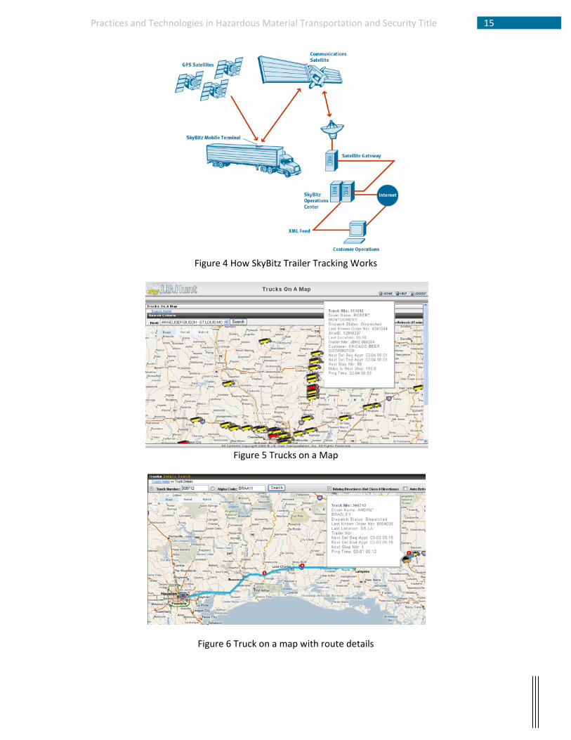
Figure 4 illustrates the operation of Skybitz for tracking trailers. It uses both GPS satellites and a
commercial satellite. Figure 4 shows a real‐time query of truck locations through an Internet
browser. Figures 5 and 6 show the location of a truck and its route. Figure 7 is the Skybitz user
interface. The geo‐fencing capability in Figure 8 allows J.B. Hunt security staff to lock the truck if
it is moved out of a defined virtual fence or limits.
Conclusion In this report, the investigator discusses several case studies relating to hazardous material
transportation and technologies used to mitigate resulting threats. In addition, based on site
visit of J.B. Hunt Transport located in Northwest Arkansas, communication technologies used to
locate trucking assets are summarized, which play a critical role in providing real‐time
information during time of spill and threat. It is clear that web‐based information and remote
sensing technologies have become necessary platforms for monitoring freight movements and
hazardous material transportation.
15Practices and Technologies in Hazardous Material Transportation and Security Title
Figure 4 How SkyBitz Trailer Tracking Works
Figure 5 Trucks on a Map
Figure 6 Truck on a map with route details
16Practices and Technologies in Hazardous Material Transportation and Security Title
Figure 7 Skybitz software interface
Figure 8 Geofencing to lock down a trailer to a defined space
17Practices and Technologies in Hazardous Material Transportation and Security Title
References
1. Freight in America. 1 1 2006. http://www.bts.gov/publications/freight_in_america/pdf/entire.pdf, Accessed September 6, 2009.
2. U.S. Department of Transportation. Hazardous Materials Information System. June 30, 2010. http://www.phmsa.dot.gov/staticfiles/PHMSA/DownloadableFiles/Files/tenyr.pdf., Accessed September 5, 2009.
4. Samina, P., A. Anderson, and R. Pitt. Development of a GIS-Based Hazardous Materials Transportation Management System: A Demonstration Project. FHWA/CA/OR-99244, University Transportation Center for Alabama, Tuscaloosa, 2000.
5. University of Kentucky, Kentucky Transportation Center, UKRF 3048103539-08-017, December 2008
6. Department of Energy. Transportation Routing Analysis Geographic Information System (TRAGIS) User's Manual. June 1 2003. https://tragis.ornl.gov/TRAGISmanual.pdf, Accessed September 12, 2009.
7. Huang, B., L. C. Ruey, and S. L. Yong. GIS and Genetic Algorithms for HAZMAT Route Planning with Security Considerations. International Journal of Geographical Information Science, Vol. 18, No. 8, 2004, pp. 769-87.
8. Martin, P. H., E. J. LeBoeuf, E. B. Daniel, J. P. Dobbins, and M. D. Abkowitz. Development of a GIS-Based Spill Management Information System. Journal of Hazardous Materials, Vol. 112, No. 3, 2004, pp. 239-252.