117
Biological Assessment Animas River Pedestrian Bridge at Aztec Ruins National Monument Prepared for HDR Engineering, Inc. September 2012 Prepared by

Biological Assessment Animas River Pedestrian Bridge at
Aztec Ruins National Monument Prepared for
HDR Engineering, Inc.
September 2012
Prepared by

Biological Assessment
Animas River Pedestrian Bridge at Aztec Ruins National Monument
San Juan County, New Mexico – District 5 Project/Control Number: F100120
Prepared by Chris Hannum, Biologist
Parametrix 8801 Jefferson NE, Building B Albuquerque, NM 87113-2439
T. 505.821.4700 F. 505.821.7131 www.parametrix.com
Prepared for
City of Aztec 201 W. Chaco Street
Aztec, NM 87410
Submitted to
New Mexico Department of Transportation Environmental Bureau
P.O. Box 1149 Santa Fe, NM 87504
September 2012

Citation Parametrix. 2012. Animas River Pedestrian
Bridge at Aztec Ruins National Monument Biological Assessment. Prepared by Parametrix,
Albuquerque, New Mexico. September 2012.

Animas River Pedestrian Bridge at Aztec Ruins National Monument Biological Assessment
i
Project/Control Number: F100120
Table of Contents
1 Introduction ............................................................ 1-1
2 PROJECT NEED AND DESCRIPTION .................. 2-1
3 METHODS ............................................................. 3-1
4 EXISTING CONDITIONS ....................................... 4-1
4.1 CLIMATE, TOPOGRAPHY AND SOILS .........................................................4-1 4.2 VEGETATION .................................................................................................4-2 4.3 NOXIOUS WEEDS..........................................................................................4-3 4.4 WILDLIFE ........................................................................................................4-3 4.5 MIGRATORY BIRDS .......................................................................................4-4 4.6 WETLANDS AND WATERWAYS ...................................................................4-7
5 PROTECTED, SENSITIVE AND MONITORED SPECIES ......................................... 5-1
5.1 SPECIES ELIMINATED FROM FURTHER ANALYSIS ..................................5-1 5.1.1 PLANTS ............................................................................................5-2 5.1.2 ANIMALS ..........................................................................................5-5
5.2 SPECIES REQUIRING FULL EVALUATION ................................................5-12 5.2.1 Species Impact Evaluations ............................................................5-13
6 Summary of Impacts .............................................. 6-1
6.1 Vegetation .......................................................................................................6-1 6.2 Wildlife .............................................................................................................6-1 6.3 Migratory Birds ................................................................................................6-2 6.4 Wetlands and Waters of the United States ......................................................6-2

City of Aztec | September 2012
ii
7 Summary of Recommendations ............................. 7-1
7.1 Vegetation .......................................................................................................7-1 7.2 Wildlife .............................................................................................................7-1 7.3 Migratory Birds ................................................................................................7-2 7.4 Wetlands and Waters of the United States ......................................................7-2
8 Contacts, Contributors, and Preparers ................... 8-1
8.1 Signatures .......................................................................................................8-1
9 Photographs of Project Area .................................. 9-1
10 References........................................................... 10-1
List of Figures Figure 1-1. Location of the Proposed Project ............................................... 1-3 Figure 4-1. Location of Biological Resources Identified in
the Project Area .................................................................................. 4-5
List of Tables Table 5-1. Special Status Species with the Potential to
Occur in the Project Area .................................................................. 5-12
List of Photographs Photograph 1. View of Area Cleared for Bore Hole on
Southeast Side of River, Looking West .......................................... 9-1 Photograph 2. Cottonwood Tree on West Side of River ......................... 9-2 Photograph 3. View of Area Cleared for Bridge Bore
Hole on Northwest Side of River, Looking East ............................ 9-2 Photograph 4. Coyote Willows on Northwest Side of
River, Looking West.......................................................................... 9-3 Photograph 5. View of Animas River from Northwest
Bank, Looking Southeast ................................................................. 9-3 Photograph 6. View of Animas River, Looking
Southwest .......................................................................................... 9-4 Photograph 7. Mule Deer Track on Northwest Side of
River ................................................................................................... 9-4 Photograph 8. Gopher Snake in Forested Area on
Northwest Side of River ................................................................... 9-5 Photograph 9. Rodent Burrow in Forested Area on
Northwest Side of River ................................................................... 9-5

Animas River Pedestrian Bridge at Aztec Ruins National Monument Biological Assessment
iii
Project/Control Number: F100120
Appendices Appendix A
Species Lists Appendix B
NMRPTC List Appendix C
Soil Report Appendix D
Observed Species Appendix E
Noxious Weed Treatments Appendix F
Correspondence

City of Aztec | September 2012
iv
This page intentionally left blank.

Animas River Pedestrian Bridge at Aztec Ruins National Monument Biological Assessment
v
Project/Control Number: F100120
Key Terms A
above mean sea level (amsl) ............................................................................................ 4-1 American Association of State Highway and Transportation Office (AASHTO) ................ 1-1 Aztec Ruins National Monument (AZRU) .......................................................................... 1-1
B best management practices (BMPs) ................................................................................. 4-8 Biological Assessment (BA) .............................................................................................. 8-1 Biota Information System of New Mexico (BISON-M) ....................................................... 3-1
C City of Aztec (City) ............................................................................................................ 1-1 Clean Water Act (CWA) .................................................................................................... 4-7
F facultative wetland (FACW) ............................................................................................... 4-7 Fahrenheit (F) ................................................................................................................... 4-1 Federal Highway Administration (FHWA) .......................................................................... 1-1 feet (ft) ............................................................................................................................... 4-1
H HDR Engineering, Inc. (HDR) ........................................................................................... 1-1 hectare (ha) ....................................................................................................................... 5-9
I inches (in) ......................................................................................................................... 4-1
L Load and Resistance Factor Design (LRFD) .................................................................... 1-1

City of Aztec | September 2012
vi
M Migratory Bird Treaty Act (MBTA) ..................................................................................... 3-1
N National Environmental Policy Act (NEPA) ....................................................................... 1-2 New Mexico Department of Agriculture (NMDA) ............................................................... 3-1 New Mexico Department of Game and Fish (NMDGF) ..................................................... 3-1 New Mexico Department of Transportation (NMDOT) ...................................................... 1-1 New Mexico Rare Plant Technical Council (NMRPTC) ..................................................... 3-1 North American Datum (NAD) ........................................................................................... 3-2 Number (No.) .................................................................................................................... 1-1
O obligate (OBL) ................................................................................................................... 4-7 ordinary high water mark (OHWM) .................................................................................... 3-2
P Preconstruction Notification (PCN) .................................................................................... 6-2
S southwestern willow flycatcher (SWFL) ........................................................................... 5-14
U U.S. Army Corps of Engineers (USACE) .......................................................................... 3-2 U.S. Department of Agriculture (USDA) ............................................................................ 3-1 U.S. Fish and Wildlife Service (USFWS) ........................................................................... 3-1 United States Geological Survey (USGS) ........................................................................... 1-2 Universal Transverse Mercator (UTM) .............................................................................. 3-2
W Western Regional Climate Center (WRCC) ...................................................................... 4-1

Animas River Pedestrian Bridge at Aztec Ruins National Monument Biological Assessment
1-1
Project/Control Number: F100120
1 Introduction The City of Aztec (City), in cooperation with the New Mexico Department of Transportation (NMDOT) and other stakeholders, proposes to construct a pedestrian trail and bridge across the Animas River, which will connect the Aztec Trail System to Aztec Ruins National Monument (AZRU). The project is located in Aztec, New Mexico, on the south side of Ruins Road (County Road 2900). The bridge would provide pedestrian access across the Animas River, and the trail on the northwest side of the river would lead from the bridge to AZRU along the south side of Ruins Road. On the southeast side of the river, the proposed trail segment would connect the existing Aztec Trail System with the pedestrian bridge. The undertaking would involve the purchase and installation of a prefabricated pedestrian bridge and construction of abutments on both sides of the Animas River. The bridge would be designed in accordance with NNMDOT requirements and American Association of State Highway and Transportation Office (AASHTO) Load and Resistance Factor Design (LRFD) Bridge Specifications. The proposed trail has been designed to involve minimal subsurface ground disturbance.
The project area includes land administered by the City and AZRU. Funding for this project will be through the 2013 NMDOT Surface Transportation Program and will include federal funds from the Federal Highway Administration (FHWA). The project has been assigned NMDOT Control Number (No.) 5100200. The City is the project proponent, and NMDOT (on behalf of FHWA) is serving as the lead reviewing agency. All resource studies follow the requirements of the NMDOT for a project using FHWA funds.
HDR Engineering, Inc. (HDR) has been contracted by the City of Aztec to design and facilitate the installation of the pedestrian bridge and trail. HDR contracted with Parametrix to conduct a wetland delineation and additional biological resource survey of the potentially affected area. The purpose of the survey is to

City of Aztec | September 2012
1-2
evaluate the project area to determine potential effects to biological resources in compliance with all necessary state and federal guidelines, including the National Environmental Policy Act (NEPA).
The project site is located in the north portion of Section 9, Township 30 North, Range 11 West (T30N, R11W) and appears on the Aztec and Flora Vista, New Mexico 7.5-minute United States Geological Survey (USGS) quadrangles (Figure 1-1).

Aztec
550
574
248
173
544
Rio Arriba County
McKinley County
San Juan County
Sandoval County
Cibola County Bernalillo County
Santa Fe County
Taos County
Torrance CountyValencia County
Mora CountyLos Alamos County
Figure 1-1. Aztec Ruins Pedestrian Bridge: Location of the Proposed Project.
0 0.5 10.25Miles
Scale
Project AreaUS HighwaysNM HighwaysNational Park Service
Anim
as Riv
er
Project Vicinity

City of Aztec | September 2012
1-4
This page intentionally left blank.

Animas River Pedestrian Bridge at Aztec Ruins National Monument Biological Assessment
2-1
Project/Control Number: F100120
2 PROJECT NEED AND DESCRIPTION As discussed above, the City proposes to construct a pedestrian trail and bridge across the Animas River, which would connect the Aztec Trail System to AZRU. The new bridge would provide pedestrian access to AZRU and encourage visitors to park on one side of the river and walk to events and facilities on the opposite side. The proposed project will involve the purchase and installation of a prefabricated pedestrian bridge and construction of abutments on both sides of the Animas River channel. Bridge design and specifications will be in accordance with the AASHTO LRFD. Although trail designs have not been finalized, the proposed trail will be constructed in a manner that will involve minimal subsurface ground disturbance. Funding for this project will be through the 2013 NMDOT Surface Transportation Program (Control No. 5100200).
The bridge and trail are needed to facilitate the linkage of Aztec’s natural, cultural, historic, and recreational resources, and to encourage visitors to park on one side of the Animas River and walk to facilities and events on the opposite side.

City of Aztec | September 2012
2-2
This page intentionally left blank.

Animas River Pedestrian Bridge at Aztec Ruins National Monument Biological Assessment
3-1
Project/Control Number: F100120
3 METHODS In accordance with state and federal laws related to protection of natural resources, a 100 percent pedestrian survey of the project area was conducted to evaluate potential impacts to threatened or endangered species, wetlands/waterways, migratory birds, and other biological resources. The right-of-way along the entire project corridor, including the proposed trail alignment and the bridge bore hole sites, was surveyed and potential impacts to the natural environment were assessed by Parametrix biologist and senior scientist, Jim Nellessen on February 22, 2011, and again on June 12 and 13, 2012, by Jim Nellessen and Parametrix biologist, Christine Hannum. Visual surveys of the adjacent areas were also conducted to evaluate the presence of suitable habitat for state- and federally-listed species. The maximum air temperature during the June 2012 surveys was approximately 92 degrees Fahrenheit, with clear skies and intermittent breezes.
Prior to the field work, lists of protected and sensitive plant and animal species in McKinley County compiled by the U.S. Fish and Wildlife Service (USFWS) (2012) and New Mexico Department of Game and Fish (NMDGF) Biota Information System of New Mexico ([BISON-M] 2011) were consulted (Appendix A). In addition, a list was obtained from the New Mexico Rare Plant Technical Council ([NMRPTC] 1999) website (Appendix B). The probability of occurrence for each listed species was evaluated based on data gathered from the BISON-M and NMRPTC websites.
The investigations also included a survey for noxious weeds as designated by the New Mexico Department of Agriculture (NMDA) and U.S. Department of Agriculture (USDA), and an evaluation of potential impacts to nesting birds protected under the Migratory Bird Treaty Act (MBTA).

City of Aztec | September 2012
3-2
The wetland delineation was carried out using methods described in the 1987 U.S. Army Corps of Engineers (USACE) Wetland Delineation Manual (Wetland Training Institute 2001), as regionally modified by the Arid West Region Supplement (USACE 2008). The ordinary high water mark (OHWM) was determined based on field observations of vegetation and soils in conjunction with water lines and local topography. A Garmin eTrex Legend HCx global positioning system capable of accuracy to less than three meters was carried to record the locations of any special status species or noxious weeds observed and to record the locations of drainage crossings and wetland boundaries. All readings were made using North American Datum (NAD) 83 Universal Transverse Mercator (UTM) coordinates.
February 22, 2011, and June 12-13, 2012 – Biological resources survey and wetland delineation of the proposed project area.
Survey Personnel Jim Nellessen Ph.D. Botany
Biological Resources Survey, Wetland Delineation
Christine Hannum B.S. Wildlife Science Biological Resources Survey, Wetland Delineation

Animas River Pedestrian Bridge at Aztec Ruins National Monument Biological Assessment
4-1
Project/Control Number: F100120
4 EXISTING CONDITIONS 4.1 CLIMATE, TOPOGRAPHY AND SOILS The climate for the project area is classified as mild and semi-arid, with an average of 9.9 inches (in) of precipitation and 130 frost-free days recorded at AZRU. Spring through early summer is the driest season; over 40 percent of the annual precipitation occurs from July to October. Average annual maximum temperature is approximately 67.9 degrees Fahrenheit (F) and the average annual minimum temperature is 34.9 degrees F (Western Regional Climate Center [WRCC] 2012).
The project area is situated on both sides of the Animas River in Aztec, New Mexico. Physiographically, it is located in the Navajo Section of the Colorado Plateau Province, which is part of a large upland region of New Mexico, Arizona, Utah, and Colorado, and is characterized by erosional landscapes carved from sequences of sedimentary and volcanic rock (Hawley 1986). The Navajo Section is dominated by the San Juan Basin, which is a low-lying drainage basin bordered by the Southern Rockies, the Four Corners Platform, and the Zuni-Defiance Uplift. In general, the Navajo Section contains hogback belts, broad rolling plains, cuetas and high tablelands, and escarpments of moderate relief (Hawley 1986). Major rivers, such as the San Juan and Animas, contain broad floodplains flanked by stepped sequences of Pleistocene-age fluvial terraces.
Elevation in the project area is approximately 5,600 feet (ft) above mean sea level (amsl). Uplands in the immediate project area are primarily level; some on the west side of the Animas River consist of former agricultural fields. Banks and slopes of the Animas River and its floodplain range from very steep and abrupt to gently sloping terraces and alluvial deposits.

City of Aztec | September 2012
4-2
Most of the soils in the project vicinity are entisols, which occur in arid environments and have usually been exposed to soil-forming processes for only a short time (in areas along floodplains or on steep slopes) (Maker and Daugherty 1986). Soils classified as Lakes, rivers, and reservoirs occur in the river channel and along some areas of riverbank. On the west side of the Animas River, soils are Turley clay loams on 1 to 3 percent slopes; this soil type is the most common in the project vicinity, comprising approximately 35 percent of the total area. These soils tend to be deep and well-drained, and are made up of fan alluvium derived from sandstone and shale. Walrees loams occur on both sides of the river and comprise 15 percent of the soils in the project vicinity (Soil Survey Staff 2012). A soil report for the project area and vicinity is included in Appendix C.
4.2 VEGETATION Native vegetation in the general region is classified as Great Basin Desert Scrub in an area modified and impacted by human activities such as farming and urban development (Dick-Peddie 1993). Dominant shrubs of Great Basin Desert Scrub are big sagebrush (Artemisia tridentata), shadscale (Atriplex confertifolia), greasewood (Sarcobatus vermiculatus), and four-wing saltbush (Atriplex canescens). Shadscale is considered the best indicator of Great Basin Desert Scrub because the other three shrub species can be very common in other vegetation associations. Big sagebrush is often the predominant shrub in Great Basin Desert Scrub because it is an increaser species; i.e., a species that increases in dominance through impacts to the plant community by such activities as over-grazing by livestock. Cully and Knight (1987) described the plant community in the project area as consisting of Atriplex species and Indian ricegrass (Achnatherum hymenoides).
The immediate project site contains a combination of riparian habitat and land that is highly modified by human activity. Along the river, narrowleaf cottonwood (Populus angustifolia), Fremont cottonwood (Populus deltoides subsp. wislizenii), coyote willow (Salix exigua), salt cedar (Tamarix sp.) and Russian olive (Elaeagnus angustifolia) comprise the overstory. Common spike-rush (Eleocharis palustris) and woolly sedge (Carex pellita) are common on the west bank of the river. Upland habitat in the abandoned agricultural fields south of Ruins Road consists of grasses and disturbed site species, such as pigweed (Amaranthus sp) and Russian thistle (Salsola tragus). Seventy eight species of plants were observed in the proposed project area during the field survey (Appendix D). Common-to-abundant non-native species found in the project area, including noxious weeds, include Russian knapweed (Acroptilon repens), Canada thistle (Cirsium arvense), Russian olive (Elaeagnus angustifolia), and Siberian elm (Ulmus pumila).

Animas River Pedestrian Bridge at Aztec Ruins National Monument Biological Assessment
4-3
Project/Control Number: F100120
4.3 NOXIOUS WEEDS The State of New Mexico, under the administration of the Department of Agriculture, lists certain weed species as being noxious. “Noxious” in this context is defined as plants not native to New Mexico that have a negative impact on the economy or environment and are targeted for management and control. Weeds listed as Class C are common, widespread species that are fairly well established within the state. Management and suppression of Class C weeds is left to the local agency’s discretion. Class B weeds are considered fairly common, but not yet widespread within certain regions of the state. The objectives for control of Class B weeds are to prevent new infestations, and in areas where they are already abundant, to contain these infestations and prevent their further spread. Class A weeds have limited distributions within the state. Preventing new infestations and eliminating existing infestations are the priorities for Class A weeds.
Nine state-listed noxious weed species were observed within the project limits. The observed species included Canada thistle (Class A weed); chicory (Cichorium intybus), Russian knapweed, and musk thistle (Carduus nutans) (Class B weeds); and bull thistle (Cirsium vulgare), cheatgrass (Bromus tectorum), Russian olive, salt cedar, and Siberian elm (Class C weeds). Siberian elm and Russian olive were common, but the two species of greatest management concern are Canada thistle and Russian knapweed, which were present in large patches on the east side of the Animas River along the proposed trail alignment. These two species are hardy perennials that form dense stands and spread via rhizomes (Figure 4-1).
Management recommendations for the control of state-listed Class A and B noxious weeds are included in Appendix E.
4.4 WILDLIFE Mammals likely to occur at AZRU on a regular basis include coyote (Canis
latrans), mule deer (Odocoileus hemionus), skunks, squirrels, many species of mice, and numerous bat species (DOI NPS 2010).
Twenty wildlife species or their signs were observed during the field survey. Since the project corridor is in a relatively well-developed suburban area on the outskirts of the City of Aztec, only those wildlife species most tolerant of, or accustomed to, human presence and activity might be expected. Some of the observed wildlife/sign includes mule deer (Odocoileus hemionus) tracks, stick nests of ravens or crows (Corvus spp.), cottontail rabbit (Lepus sp. and/or Sylvilagus sp.) pellets, pocket gopher (Thomomys bottae) burrows, turkey vultures (Cathartes aura), and barn swallows (Hirundo rustica) (Photographs 7 and 8). Appendix D contains a complete list of wildlife species observed during the surveys.

City of Aztec | September 2012
4-4
4.5 MIGRATORY BIRDS Pursuant to the Migratory Bird Treaty Act (16 U.S.C. 703-712), it is unlawful to take, kill, or possess migratory birds, their parts, nests, or eggs. Take is defined as pursuit, hunting, shooting, wounding, killing, trapping, capturing, or collecting (50 CFR 10.12). This law applies to both intentional and unintentional harmful conduct. If taking of migratory birds, their parts, nests, or eggs is determined by a project proponent to be the only alternative, a Migratory Bird Permit must be obtained through the Migratory Bird Permit Office of the USFWS (50 CFR 13, 21). The optimum time for removal of unoccupied nests occurs from September through mid-February.
Birds observed during the field surveys include black-chinned hummingbird (Archilochus alexandri), house finch (Carpodacus mexicanus), turkey vulture (Cathartes aura), common raven (Corvus corax), yellow warbler (Dendroica petechia), common yellowthroat (Geothlypis trichas), barn swallow (Hirundo rustica), yellow-breasted chat (Icteria virens), ash-throated flycatcher (Myiarchus cinerascens), black-headed grosbeak (Pheucticus melanocephalus), hairy woodpecker (Picoides pubescens), downy woodpecker (Picoides villosus), western bluebird (Sialia mexicana), white-breasted nuthatch (Sitta carolinensis), American robin (Turdus migratorius), and mourning dove (Zenaida macroura). All of the birds observed during the survey are protected under the MBTA.
Bird nests were observed in trees in scattered locations throughout the project area (Figure 4-1). Several of the nests were large and constructed of sticks (most likely attributable to ravens and/or crows); other nests were cavities. Although the surveys were conducted during breeding season, none of the nests appeared to be active. The breeding season for migratory birds generally begins as early as March and continues into early September Special status species are discussed in Section 5, Protected, Sensitive, and Species of Concern.

County Road 2900
BN-1
BN-2
BN-3BN-4 BN-5
Figure 4-1. Aztec Ruins Pedestrian Bridge: Biological Features and Waters of the U.S. within the Proposed Project Area.
UTM coordinates: NAD 83/13N
0 260 520130Feet
Scale
Bore Hole SitesBird Nest (BN)Proposed Pedestrian Bridge & TrailOrdinary High Water MarkProject Area
Previously Cleared by AZRUCanada ThistleWetland BoundaryRussian Knapweed

City of Aztec | September 2012
4-6
This page intentionally left blank.

Animas River Pedestrian Bridge at Aztec Ruins National Monument Biological Assessment
4-7
Project/Control Number: F100120
4.6 WETLANDS AND WATERWAYS Wetlands are areas that are inundated or saturated by surface or ground water at a frequency and duration sufficient to support, and that under normal circumstances do support, a prevalence of vegetation typically adapted for life in saturated soil conditions (EPA, 40 CFR 230.3 and CE 33 CFR 328.3). Jurisdictional wetlands, those protected from unauthorized dredge and fill activities under Section 404 of the Clean Water Act (CWA) (33 USC 1344) and Executive Order 11990, have three essential characteristics: (1) dominance by hydrophytic vegetation, (2) hydric soils, and (3) wetland hydrology. Hydrophytic vegetation requires inundation or soil saturation for its survival. Hydric soils are ponded or flooded for a sufficient time during the growing season to develop anaerobic conditions. Generally, the hydrology of the wetland is such that the area is permanently or periodically inundated or saturated at the surface for a period of time during the growing season.
The Animas River is a perennial stream and, under the definitions in the CWA, is classified as a water of the U.S. The OHWM was determined based on field observations of vegetation and soils in conjunction with water lines and local topography.
Two wetlands, covering a combined total of 0.8 acre, were delineated within the study area. Wetland 1 is a narrow strip along the river bank on the east side of the Animas River and includes steep river banks and fringe areas. Wetland 2 is located on the west side of the river between the channel and an area cleared of invasive plant species by AZRU for the purpose of fire control. The Animas River is classified as a navigable perennial stream, making it a jurisdictional waterway; therefore, adjacent bank wetlands are also jurisdictional and subject to regulation by the USACE. The proposed bore hole sites for the bridge abutments occur outside the identified wetlands. Soils in the wetland areas are mapped as lakes, rivers and reservoirs, Walrees loam, and Turley clay loam with 1 to 3 percent slopes. Soils classified as Lakes, rivers and reservoirs occur in the river channel and along some areas of riverbank. Walrees loam soils are typically deep and somewhat poorly drained and are occasionally subject to flooding. Turley clay loam soils are deep and well-drained and are not subject to flooding. In general, soils at the sample wetland pits met the standards for hydric soils, and were often characterized by stratified layers and sandy or loamy gleyed matrices. Vegetation was dominated by obligate (OBL) wetland species such as woolly sedge (Carex
pellita), common spike-rush (Eleocharis palustris), and common threesquare (Schoenoplectus pungens), and facultative wetland (FACW) species such as coyote willow (Salix exigua) and smooth scouring-rush (Equisetum laevigatum). Hydrology was provided by groundwater close to the surface.

City of Aztec | September 2012
4-8
Wetlands functions are defined as a process or series of processes that take place within a wetland. These functions fall within three general categories – physical, chemical, and biological. The value of wetlands is a measure of the estimated worth of the individual wetland functions to society. A full functional analysis of the wetlands in the proposed project area is outside the scope of this assessment. Generally, these wetlands provide forage and cover for a variety of species.
The Animas River is classified as a navigable perennial stream, making it a jurisdictional waterway; therefore, adjacent bank wetlands are also jurisdictional and subject to regulation by the USACE. Design plans for the pedestrian bridge are intended to avoid impacts to waters of the U.S., including wetlands. The proposed bore hole sites for the bridge abutments occur outside the identified wetlands. As long as the bridge fully spans the OHWM limits as shown in Figure 4-1, there will be no impacts to waters of the U.S. If bank protection measures are needed at the bridge abutments, and if any of these protection measures require the placement of fill below the OHWM, then a Section 404 permit from the USACE is anticipated. If a Section 404 permit should be required, it is anticipated that work can be achieved under one of the USACE’s Nationwide Permits.
To protect water quality downstream in the Animas River it is recommended that best management practices (BMPs) be implemented. BMPs may involve the use of hay bales, straw wattles, and/or silt fences adjacent to the river banks to avoid sediments from entering the channel. BMPs would also include storing fuels and solvents at least 200 ft away from the river banks and inspecting motorized construction equipment for leaking fluids. The bridge and its abutments are expected to completely span the river as shown in Figure 4-1. If the bridge completely spans the river and the BMPs as described are implemented, impacts to water quality in the Animas River would be avoided.

Animas River Pedestrian Bridge at Aztec Ruins National Monument Biological Assessment
5-1
Project/Control Number: F100120
5 PROTECTED, SENSITIVE AND MONITORED SPECIES The USFWS has responsibility for implementing the Endangered Species Act, including listing species as threatened, endangered, candidate, or species of concern, and for protection of these species. The USFWS also lists some species as species of concern, indicating that the species population and/or distribution may be declining. The USFWS monitors information for species of concern to determine whether they may warrant future listing. For this report, federal and state lists for protected species in San Juan County were examined; those lists are included in Appendices A and B. The habitat requirements of listed species were compared to the habitat at the proposed project location to identify those with potential to occur in the project area. Species considered unlikely to occur, or for which suitable habitat did not exist within the proposed project area, were eliminated from further consideration.
5.1 SPECIES ELIMINATED FROM FURTHER ANALYSIS
Each species identified in the county lists was researched to determine its potential for occurrence within the project limits. The primary criteria for the exclusion of species includes elevation restrictions, lack of suitable habitat, lack of suitable soil types, topographic preferences, species mobility in conjunction with the nature of the project, and occasionally range or distribution confinement where finding a particular species in the vicinity of the project corridor would be extremely unlikely. Unless otherwise noted, species and habitat information for animals in this section was obtained from the BISON-M online database, and for plants, from the New Mexico Rare Plant Technical Council (NMRPTC) website.

City of Aztec | September 2012
5-2
5.1.1 PLANTS
The following plant species were eliminated from further analysis on the basis of a combination of known population locations, soil types, and elevation. None of these species was observed in the project area during the biological surveys.
Arboles milkvetch (Astragalus oocalycis)
This is a state and federal species of concern that occurs at elevations of 5,600 to 7,200 feet amsl. It is typically found on seleniferous clay soils, such as those in the Mancos Formation, along with sagebrush, piñon-juniper woodland, and in transitional areas between piñon-juniper woodland and ponderosa pine forest. The Mancos Formation consists of siltstone-shale, which is not present in the project corridor. Due to the lack of appropriate habitat in the project area, this species was eliminated from further analysis.
Aztec gilia (Aliciella formosa)
This is a federal species of concern and a state endangered species. It is found in San Juan County in salt desert scrub vegetation communities at elevations of 5,000 to 6,400 ft amsl. Aztec gilia grows exclusively in soils derived from the Nacimiento Formation, which is a combination of shale, siltstone, and sandstone. The required soils do not occur in the project corridor; therefore, this species was eliminated from further analysis.
Bisti fleabane (Erigeron bistiensis)
This is a federal species of concern that is commonly found in clay, clay-silt and gravelly soils that are seleniferous, saline or gypseous. It occurs in salt desert scrub and piñon-juniper habitats at elevations of 4,200 to 6,900 ft amsl (Flora of North America Editorial Committee 1993). There is no salt desert scrub or piñon habitat in the project area; therefore, this species was eliminated from further analysis.
Bolack’s sand verbena (Abronia bolackii)
This is a federal and state species of concern that occurs in gypsiferous clay soils, often on very steep slopes with junipers, Mormon tea, and cliffrose, or on sandy shale with Atriplex spp. It is typically found at elevations of 5,250 to 5,750 ft amsl. The required soils do not occur in the project corridor; therefore, this species was eliminated from further analysis.
Brack’s fishhook cactus (Sclerocactus cloveriae ssp. brackii)
This is a federal species of concern that is also listed as endangered by the state of New Mexico. It is known to occur in a limited distribution on both sides of the San Juan River valley on sandy clay strata of the Nacimiento Formation. It is

Animas River Pedestrian Bridge at Aztec Ruins National Monument Biological Assessment
5-3
Project/Control Number: F100120
typically found at elevations of 5,000 to 6,400 ft amsl. The required soils do not occur in the project corridor; therefore, this species was eliminated from further analysis.
Chaco milkvetch (Astragalus micromerius)
This is a federal and state species of concern that occurs at elevations of 6,600 to 7,300 ft amsl, and inhabits gypseous or limy sandstone substrates in piñon-juniper woodland and Great Basin Desert Scrub. The elevation and substrates in the project area do not meet this plant’s requirements; therefore, this species was eliminated from further analysis.
Chuska milkvetch (Astragalus chuskanus)
This is a federal and state species of concern that occurs in montane coniferous forests at elevations above 5,500 ft amsl on degraded Chuska sandstone. In San Juan County, the species is limited to the Chuska Mountains, which are located southwest of the project area. The necessary habitat components for this species do not exist in the project corridor; therefore, it was eliminated from further analysis.
Clifford’s gilia (Aliciella cliffordii)
This is a federal and state species of concern that is known from Beautiful Mountain in far western New Mexico, and from areas west of Shiprock. It occurs in Utah juniper-piñon and ponderosa pine communities, typically on red, sandy or clay soils of the Wingate Formation and the Owl Rock Member of the Chinle Formation at elevations of 5,000 to 6,500 ft amsl. The required habitat does not occur in the project corridor; therefore, this species has been eliminated from further analysis.
Cottam’s milkvetch (Astragalus cottamii)
This is a federal and state species of concern that occurs in piñon-juniper woodlands. It is typically found in weathered depressions and crevices in sandstone substrates of Cretaceous origin at elevations of 5,000 to 6,000 ft amsl. The required soils and habitat do not occur in the project corridor; therefore, this species was eliminated from further analysis.
Knowlton cactus (Pediocactus knowltonii)
This is a federal endangered species. It is found in piñon-juniper-sagebrush communities on gravelly, rolling hills at elevations of 6,200 to 6,300 ft amsl. The species has been found only near the Los Pinos River in extreme northeastern San Juan County, New Mexico near the Colorado border. Due to its limited known distribution outside the project corridor, this species was eliminated from further analysis.

City of Aztec | September 2012
5-4
Mancos milk-vetch (Astragalus humillimus)
This is a federal endangered species that occurs in cracks or depressions on ledges of sandstone rimrock and mesa tops of Point Lookout sandstone at elevations of 5,000 to 6,000 ft amsl. The project area is primarily riverine, with sandy or clayey soils. There are no substrates consisting of sandstone in the project footprint; therefore, this species was eliminated from further analysis.
Mancos saltplant (Proatriplex pleiantha)
This is a federal and state species of concern that occurs on saline clay soils of the Mancos and Fruitland shale formations in the desert badlands of the Colorado Plateau. It is typically found at elevations of 5,000 to 5,500 ft amsl. The riverine and agricultural upland habitat of the project area does not contain shale formations; therefore, this species was eliminated from further analysis.
Mesa Verde cactus (Sclerocactus mesae-verdae)
This species is listed as endangered by the USFWS and as threatened by the State of New Mexico. It is found at elevations of 4,900 to 5,500 ft amsl in low rolling clay hills with sparse vegetation and very alkaline, gypsiferous soils. The soil types required by this species are not found in the project footprint; therefore, the Mesa Verde cactus was eliminated from further analysis.
Navajo Mountain phlox (Phlox cluteana)
This is a federal and state species of concern that is found in lightly to heavily shaded areas on sandy soils in ponderosa pine forest. Known only from the Chuska Mountains in San Juan County, this species occurs at elevations of 6,000 to 10,000 ft amsl. The limited known distribution of this species places it outside the project area and it was not observed during the field surveys; therefore, it was eliminated from further analysis.
Parish’s alkali grass (Puccinellia parishii)
This is a federal species of concern and state endangered species. It is found near alkaline springs and seeps at elevations ranging from 2,600 to 7,200 ft amsl and requires continuous soil moisture during its growing period. Habitat in the project corridor does not meet the requirements for this species and it was not observed during field surveys; therefore, it was eliminated from further analysis.

Animas River Pedestrian Bridge at Aztec Ruins National Monument Biological Assessment
5-5
Project/Control Number: F100120
San Juan milkweed (Asclepias sanjuanensis)
This is a state and federal species of concern that occurs on sandy loam soils in juniper savanna and Great Basin desert scrub. It is typically found at elevations of 5,000 to 5,500 ft amsl, often in disturbed areas. The riverine habitat in the project footprint does not meet the requirements for this species; therefore, it was eliminated from further analysis.
Zuni fleabane (Erigeron rhizomatus)
This is a federally-listed threatened and state-listed endangered species most commonly found on north- or east-facing slopes of barren, clay hillsides in pinon-juniper woodlands at elevations of 7,300 to 8,000 ft amsl. The closest known population is in the Chuska Mountains, southwest of Aztec. The necessary habitat components for this species do not exist in the project corridor; therefore, it was eliminated from further analysis.
5.1.2 ANIMALS
None of the following wildlife species was observed in the project area during the biological surveys.
5.1.2.1 Birds
No raptor nests are known to exist in or near the project area as of the date of this document. Potential raptor nesting habitat does exist within the project corridor, however, and raptors could also travel through the area or use it for hunting or roosting.
American and arctic peregrine falcon (Falco peregrinus anatum/ F. p. tundrius)
These are federal species of concern and state threatened species that are protected under the MBTA. These subspecies breed in mountainous areas and occur during migration and winter primarily in the eastern plains. They summer and nest on tall, steep, rocky cliffs associated with forest or woodland in close proximity to water. In New Mexico, the breeding territories of peregrine falcons center on cliffs that are in wooded/forested habitats, with large “gulfs” of air nearby in which these predators can forage. Preferred nest site is a cliff around 200 feet in height usually below 9,500 feet amsl. Characteristic nesting or roosting habitat is not present in the project area; therefore, both subspecies were eliminated from further analysis.
City of Aztec | September 2012
5-6
Baird’s sparrow (Ammodramus bairdii)
This is a federal species of concern and a state threatened species; it is protected under the MBTA. A variety of habitats are used by the sparrow, including desert grasslands in southern New Mexico and mountain meadows up to an elevation of approximately 11,800 ft amsl in the Sangre de Cristo and San Juan mountains. Grasslands are particularly important for this shy species due to its reliance on grass for cover and grass seed for food. This species has rarely been documented in the spring season in New Mexico, and typically first appears in early August. It appears that the sparrow does not breed in this state. The necessary grassland habitat does not occur in the project corridor; therefore, this species has been eliminated from further analysis.
Bald eagle (Haliaeetus leucocephalus)
The bald eagle is listed as threatened in New Mexico and has protection under the MBTA and the Bald and Golden Eagle Protection Act. Bald eagle habitat is found in the riparian zones along the Rio Grande, Pecos, Chama, Gila, San Juan, and Canadian rivers. Key habitat areas in New Mexico include winter roosts and concentration areas such as Navajo Lake, the Chama Valley, Cochiti Lake, northeastern lakes near Las Vegas and Raton, the Lower Canadian River, Sumner Lake, Elephant Butte Lake, and the upper Gila Basin. The bald eagle is associated with aquatic ecosystems throughout most of its range. Bald eagles are uncommon during the summer and have limited breeding sites in New Mexico, though nests have been documented in the extreme northern and western portions of the state. Bald eagles require large trees or cliffs near water with abundant fish for nesting. The project vicinity does not contain nesting habitat for bald eagles, although they may occasionally fly or forage through the area. No nests attributable to eagles were observed within the project area during the survey; therefore, this species was eliminated from further analysis.
Black swift (Cypseloides niger borealis)
This is a state sensitive species that is protected under the MBTA. The swift is found in a variety of habitat types, ranging from riparian woodland to alpine meadows. This species requires high cliffs near permanent water for nesting, and it forages for invertebrates over wetland and aquatic areas. There is no nesting habitat for black swifts in the project area although the species may forage along the Animas River. It is unlikely that the species, if present, would be disturbed by construction activities. Therefore, it was eliminated from further analysis.

Animas River Pedestrian Bridge at Aztec Ruins National Monument Biological Assessment
5-7
Project/Control Number: F100120
Black tern (Chlidonias niger)
This is a federal species of concern that is protected under the MBTA. This species nests around marshes, ponds, and lakes, generally at lower elevations, and may also be found in areas dominated by annual grassland or farms. Areas with sufficient moisture for plant growth appear to be important for the species. Characteristic habitat is not present in the project area; therefore, this species was eliminated from further analysis.
Broad-billed hummingbird (Cynanthus latirostris)
This is a state threatened species that is protected under the MBTA. It is primarily found in low-to-mid elevation riparian woodlands, and in New Mexico typically occurs only in the extreme southwestern portion of the state. It is highly unlikely that this hummingbird would be found in San Juan County; if it were present in northwestern New Mexico, it would be as an accidental or transient species; therefore, the broad-billed hummingbird has been eliminated from further analysis.
Brown pelican (Pelecanus occidentalis carolinensis)
This species is listed as endangered in New Mexico that is protec ted under the MBTA. These birds do not breed in New Mexico and are generally only found around large bodies of water while passing through the State. The brown pelican is usually found in marine habitats in warmer waters in North America; except for the lower Colorado Basin and vicinity, it only rarely occurs inland. The species feeds exclusively on fish, which it usually obtains by diving head-first from heights of up to 65 feet. No characteristic habitat for this species is present in the project area; therefore, the brown pelican has been eliminated from further analysis.
Common black-hawk (Buteogallus anthracinus anthracinus)
This is a federal species of concern and a state-listed threatened species that also has protection under the MBTA. In the southwest, this species is typically found along stream and river corridors with cottonwoods and other riparian tree species. The black-hawk is an uncommon summer resident in New Mexico; its numbers are highest in the Gila Basin in the southwestern part of the state, but it is more often a migrant or vagrant species. It is highly unlikely that this species would be found in the project area; therefore, it was eliminated from further analysis.
Gray vireo (Vireo vicinior)
This is a state threatened species that is protected under the MBTA. The vireo is found in New Mexico from April to September on foothills and mesas in arid juniper woodlands. Numbers of gray vireos appear to be increasing in the state.

City of Aztec | September 2012
5-8
The breeding habitat is generally open woodlands/shrublands featuring evergreen trees, especially juniper and oaks, along with shrubs. The project corridor lacks the vegetation community required by the gray vireo; therefore, it was eliminated from further analysis.
Least tern (Sterna antillarum athalassos)
This species is listed as endangered by the USFWS and by the state of New Mexico, and is protected under the MBTA. It is found in riparian or marshy areas with sandy alkali flats or playas essentially devoid of vegetation. Productivity of this species in New Mexico is poor, with very few breeding pairs in the state; the tern is more often a transient or accidental species in New Mexico. The tern’s preferred habitat is not found in the project corridor; therefore, it was eliminated from further analysis.
Mexican spotted owl (Strix occidentalis lucida)
This is a federal threatened and state sensitive species that is protected under the MBTA. Habitat characteristics highly sought by Mexican spotted owls include high canopy closure, high stand density, a multi-layered canopy, uneven-aged stands, numerous snags, and downed woody matter. These are best expressed in old-growth mixed-conifer forests (usually more than 200 years old). These characteristics may also develop in younger stands that are unmanaged or minimally managed, especially when the stands contain remnant large trees or patches of large trees from earlier stands. The USFWS has designated Critical Habitat for this species in the State of New Mexico; however, the closest Designated Critical Habitat is in the Carson National Forest, more than 40 miles southeast of the project area. Characteristic habitat for this species is not present in the project corridor; therefore, this species was eliminated from further analysis.
Mountain plover (Charadrius montanus)
This is a state sensitive species that is also protected under the MBTA. The plover is found in lowland grasslands and on open plains and mesas. Mountain plovers are considered to be strongly associated with sites of heaviest grazing pressure to the point of excessive surface disturbance. The mountain plover is also attracted to man-made landscapes (e.g., sod farms, cultivated fields) that mimic natural habitat associations, or sites with grassland characteristics (alkali flats, other agricultural lands). The BISON-M website Predicted Habitat map shows the project area to be far northwest of the closest predicted habitat. No plovers were observed during field surveys; therefore, this species was eliminated from further analysis.

Animas River Pedestrian Bridge at Aztec Ruins National Monument Biological Assessment
5-9
Project/Control Number: F100120
Northern goshawk (Accipiter gentilis)
This is a federal species of concern and state sensitive species that is protected under the MBTA. The typical habitat for this species consists of moderate- to high-canopied mature (200+ years, old growth) conifer forests with minimal understory. Northern goshawk habitat occurs in ponderosa pine and mixed conifer forest. The breeding season is from May through August. Nest sites are usually located in forest stands supporting a high density of large trees and canopy closure. Large trees (greater than 18 inches in diameter) provide viable nesting sites for goshawks. Goshawks apparently prefer to nest within 1/4 mile of water in forest blocks greater than 80 hectare (ha) in size that contain small openings. In general, nest sites have large trees, dense canopies, and in the southern portion of the hawk’s range, are typically on slopes with northerly aspects. Characteristic habitat for this species is not present in the project area; therefore, it was eliminated from further analysis.
Sprague’s pipit (Anthus spragueii)
This is a federal candidate species that has protection under the MBTA. The pipit is a grassland species that is a regular migrant in New Mexico. It is typically found at elevations below 5,500 ft amsl, and breeds in shortgrass prairies. The pipit nests in a hollow on the ground. This species will use areas under moderate grazing pressure, but avoids areas with heavier grazing. It is highly unlikely that Sprague’s pipit would use the project area; most individuals have been observed only in southern New Mexico. Therefore, this species has been eliminated from further analysis.
Western burrowing owl (Athene cunicularia hypugaea)
This is a federal species of concern and is protected under the Migratory Bird Treaty Act. This small owl nests in burrows in grassland, shrubland, or savanna, often taking over abandoned prairie dog burrows. They will also use abandoned burrows of ground squirrels, woodchucks, foxes, badgers, and armadillos. Ground squirrels and their burrows observed during the survey were confined to road-cut embankments at the very north end of the project area and were not large enough to contain burrowing owl nests. Suitable burrows were not observed within in the project area; therefore, this species was eliminated from further analysis.
5.1.2.2 Mammals
Black-footed ferret (Mustela nigripes)
This is a federal endangered species that is thought to be extirpated in New Mexico. Prairie dog colonies are essential black-footed ferret habitat. Based on ferret energy needs, prairie dog energy yields, population dynamics of both

City of Aztec | September 2012
5-10
species and related factors, it has been calculated that a single female black -footed ferret and her litter would require a population of 474 to 1,421 (median 766) black-tailed and 417 to 1,236 (median 666) white-tailed prairie dogs. Annual harvest from these populations would be 214 black-tailed and 186 white-tailed prairie dogs. In order to sustain the prey base, 91 to 235 acres of black-tailed and 212 to 877 acres of white-tailed prairie dogs would be needed at average prairie dog densities of 6.1/acre and 1.6/acre, respectively. No prairie dogs or their burrows were observed in the project vicinity; therefore, this species was eliminated from further analysis.
Canada Lynx (Lynx canadensis)
This is a federal candidate species that possibly occurs in New Mexico according to the USFWS. Colorado’s wildlife division started re-introduction efforts in 1998 and 60 lynx made short forays into New Mexico. While there is no documentation of year-round residency or reproduction, there is the potential for such behavior. Lynx are typically found in subalpine/coniferous forests up to approximately 10,500 ft amsl and in New Mexico would most likely be confined to the mountains of the extreme northeastern part of the state. The lynx’s primary prey, the snowshoe hare, requires the same type of habitat. No characteristic habitat for this species occurs in the project area; therefore, it was eliminated from further analysis.
Gunnison’s prairie dog – montane and prairie populations (Cynomys
gunnisoni gunnisoni)
Prairie populations are a State sensitive subspecies. Montane populations are a federal candidate and State sensitive subspecies. Gunnison’s prairie dogs occur in low valleys, but also are common in parks and meadows in the montane forests up to at least 10,000 ft. They have been reported as high as 12,000 ft in Colorado. Prairie dogs live in short-grass and mid-grass prairies, grass-shrub habitats, and open meadows and brush-lands of high mountain valleys and plateaus. Although potential habitat for this species is present within the project area, no prairie dogs or prairie dog burrows were observed during the biological survey; therefore, this species was eliminated from further analysis.
Red fox (Vulpes vulpes)
This is a State sensitive species. Across North America the red fox is most common in open woodlands, pasturelands, riparian, and agricultural lands. It favors areas with a mixture of the vegetation types occurring in small mosaics with good development of ground cover. Red foxes also do well on the margins of urbanized areas and are common in open space and other undeveloped areas adjacent to cities along the Front Range corridor. In the mountains they occur in

Animas River Pedestrian Bridge at Aztec Ruins National Monument Biological Assessment
5-11
Project/Control Number: F100120
montane and subalpine meadows as well as in alpine and forest edges, usually near water. While potential habitat for this species is present within the project area, its high degree of mobility and suitable habitat statewide, combined with the minimally invasive nature of the proposed project, which would result in almost no loss of habitat, made it reasonable to eliminate this species from further analysis.
Ringtail (Bassariscus astutus)
This is a state sensitive species. Seldom far from a perennial water source, ringtails inhabit talus cliffs, rocky canyons, chaparral, scrub oak, piñon-juniper, riparian woodlands, and occasionally evergreen forests. The species lives in extensive rocky areas and cliffs in grassland and woodland where it may be common, but observations and specimens are rare. The species is most common in the southern half of the State. Characteristic habitat for ringtails is not present within the project area; therefore, this species was eliminated from further analysis.
Western spotted skunk (Spilogale gracilis)
This is a State sensitive species. They are inhabitants of rocky and brushy areas in woodland, grassland, and desert. It is a species of the semiarid West and most common in shrub habitats of broken country. It can be found in montane forest and shrubland, semidesert shrubland, and piñon-juniper woodlands at elevations up to 8,000 feet amsl. It is remotely possible that this species could occur within the project area; however, the high degree of mobility and the minimally invasive nature of the proposed project, which would result in almost no loss of habitat, made it reasonable to eliminate this species from further analysis.
Yellow-bellied marmot (Marmota flavivetris lunteola)
This is a state sensitive species that most commonly occurs in New Mexico in the Sangre de Cristo and San Juan Mountains. They typically inhabit meadows in spruce-fir forest from approximately 10,000 ft to well above timberline, where they favor rock slides and boulder piles. Marmots have also been recorded at 5,980 ft in northeastern San Juan County. The project area does not contain the preferred habitat type for this species; therefore, it has been eliminated from further analysis.
City of Aztec | September 2012
5-12
5.1.2.3 Invertebrates
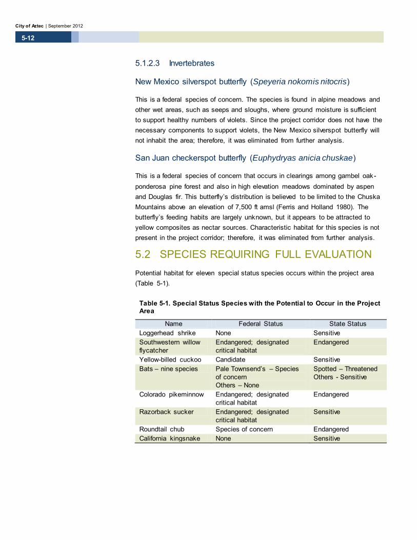
New Mexico silverspot butterfly (Speyeria nokomis nitocris)
This is a federal species of concern. The species is found in alpine meadows and other wet areas, such as seeps and sloughs, where ground moisture is sufficient to support healthy numbers of violets. Since the project corridor does not have the necessary components to support violets, the New Mexico silverspot butterfly will not inhabit the area; therefore, it was eliminated from further analysis.
San Juan checkerspot butterfly (Euphydryas anicia chuskae)
This is a federal species of concern that occurs in clearings among gambel oak -ponderosa pine forest and also in high elevation meadows dominated by aspen and Douglas fir. This butterfly’s distribution is believed to be limited to the Chuska Mountains above an elevation of 7,500 ft amsl (Ferris and Holland 1980). The butterfly’s feeding habits are largely unknown, but it appears to be attracted to yellow composites as nectar sources. Characteristic habitat for this species is not present in the project corridor; therefore, it was eliminated from further analysis.
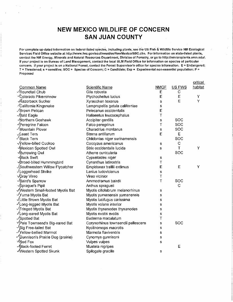
5.2 SPECIES REQUIRING FULL EVALUATION Potential habitat for eleven special status species occurs within the project area (Table 5-1).
Table 5-1. Special Status Species with the Potential to Occur in the Project Area
Name Federal Status State Status Loggerhead shrike None Sensitive Southwestern willow flycatcher
Endangered; designated critical habitat
Endangered
Yellow-billed cuckoo Candidate Sensitive Bats – nine species Pale Townsend’s – Species
of concern Others – None
Spotted – Threatened Others - Sensitive
Colorado pikeminnow Endangered; designated critical habitat
Endangered
Razorback sucker Endangered; designated critical habitat
Sensitive
Roundtail chub Species of concern Endangered California kingsnake None Sensitive

Animas River Pedestrian Bridge at Aztec Ruins National Monument Biological Assessment
5-13
Project/Control Number: F100120
5.2.1 Species Impact Evaluations
5.2.1.1 Birds
Species Name – Loggerhead shrike (Lanius ludovicianus).
A. Species Ecology
This is a state sensitive species that is protected under the MBTA. This species occurs throughout New Mexico in a variety of habitats ranging from agricultural areas and desert scrub to mountain and alpine meadows. Shrikes nest in trees at heights of approximately 5 to 29 ft above the ground. They typically breed between May and July, and will usually re-nest if a nest is destroyed. Shrikes feed on insects as well as small mammals and hunt from elevated perches. Declining numbers of loggerhead shrikes is attributed to their consumption of pesticide-contaminated prey and to the loss of grassland and pastureland feeding habitat.
B. Data Sources (including surveys conducted)
Biota Information System of New Mexico (BISON-M) online database and biological surveys conducted on June 12 and 13, 2012.
C. Affected Habitat Description
The project area contains riverine and deciduous forest habitat, as well as abandoned agricultural land on the west side of the Animas River. Although no shrikes were observed during surveys, they may pass through or temporarily use the agricultural land adjacent to the project area for hunting. The potential for nesting birds inside the boundaries of the project corridor is very low due to the small size of the project footprint and the amount of human disturbance in the area.
D. Analysis of Effects
Loggerhead shrikes were not observed in the project area during the June 2012 biological surveys. Excessive noise and ground disturbance associated with construction activities could disrupt hunting and feeding behavior. Shrikes would likely avoid the area for hunting during construction. There would be no loss of preferred shrike habitat.
E. Determination of Effect/Recommended Mitigation
If shrikes use the project area for hunting, they may be subject to noise from construction equipment that could disrupt their hunting/feeding behavior. It is unlikely that shrikes would nest in the area; however, if construction ac tivities

City of Aztec | September 2012
5-14
were to take place between April and August, trees marked for removal should be removed between early September and mid-February to prevent delaying the start of construction.
F. Finding
If the above mitigation measure is implemented, no impacts to loggerhead shrikes would be expected as a result of this project.
Species Name – Southwestern willow flycatcher (Empidonax traillii
extimus)
A. Species Ecology
The southwestern willow flycatcher (SWFL) is protected as an endangered species by the USFWS and the State of New Mexico, and has additional protection under the MBTA. Loss of riparian and wetland habitat types, especially in recent years, is a threat to migratory and breeding behavior.
In New Mexico, the species is known to inhabit riparian areas with dense, wide corridors of coyote willow, arrowweed, buttonbush, tamarisk, and Russian olive. Typical nesting habitat consists of thickets of trees and shrubs of various heights, commonly 6.5 to 23 ft tall, with a dense understory extending from ground or surface level to 13 ft or more in height. Main stem structure of woody vegetation chosen for nesting is typically 2 centimeters in diameter. In tamarisk habitat, the average nest height is 13 to 19 ft above ground surface. Slow-moving or still surface water and/or saturated soils are important components of SWFL habitat. Because they create slow-moving water, beavers are often found in association with SWFLs.
This species breeds in riparian habitats from southern California to southern Utah, and west Texas, and is found in the U.S. from May to September; it winters in southern Mexico, and Central and northern South America. SWFLs arrive in New Mexico in late April to nest, and the young fledge in early summer. During the spring and fall migrations, the flycatcher occurs statewide in New Mexico. The SWFL breeds along rivers in New Mexico, including the Chama, Zuni, San Juan, Gila, Rio Hondo, and Rio Grande. Flycatchers have been reported in San Juan County.
The closest historic breeding site of the SWFL is along the Rio Chama (Rio Arriba County). Small breeding populations have been identified in recent years along portions of the San Juan River drainage (USFWS 2012). Although critical habitat has been designated for the SWFL, there is none in the project area or within San Juan County. Per Debra Hill at USFWS (personal communication, 3/19/12), habitat in the project corridor is marginal and there are no known breeding SWFLs in the area, although migrants are known to pass through.

Animas River Pedestrian Bridge at Aztec Ruins National Monument Biological Assessment
5-15
Project/Control Number: F100120
B. Data Sources (including surveys conducted)
Biota Information System of New Mexico (BISON-M) online database, USFWS SWFL Survey Protocol course, and biological surveys conducted on June 12 and 13, 2012.
C. Affected Habitat Description
The habitat conditions at the project site are considered very marginal. Although coyote willow is present, the strips are relatively narrow. The willows on the east bank are rather young and short in stature (mostly 5 ft tall or less). Even with the Russian olive and cottonwoods included, the riparian areas are not considered high quality.
D. Analysis of Effects
Construction activities may affect the marginal SWFL habitat on the west side of the Animas River. The lack of breeding habitat and the small amount of vegetation removed in the project area, however, make it unlikely that there would be adverse effects on SWFL behavior or survival.
E. Determination of Effect/Recommended Mitigation
As with any other species of migratory bird, nesting habitat should be cleared outside of the typical nesting season (October through early March) in preparation for construction. All removal of woody plants along the river and proposed trail route should be accomplished during this time frame. Conservation measures should include planting coyote willows elsewhere in the project area to mitigate any tree removal necessitated by bridge construction.
F. Finding
If the above mitigation measures are implemented, no impacts to the yellow-billed cuckoo would be expected.
Species Name – Yellow-billed cuckoo (Coccyzus americanus)
A. Species Ecology
The yellow-billed cuckoo in recent years has been under status review by the USFWS and is currently a candidate for listing as threatened. The western population (C. americanus occidentalis) is considered a riparian obligate. The cuckoo inhabits broad-leaf deciduous riparian woodlands, willow and alder thickets, second-growth forests, deserted farmlands, and orchards, and breeds in riparian habitat that most commonly contains cottonwoods and willows. The

City of Aztec | September 2012
5-16
species also breeds in dense salt cedar tracts along parts of the Pecos River. This species is known to be present in New Mexico in spring, summer and fall, typically arriving in late May or early June; the cuckoo winters south of the U.S./Mexico border.
A dense understory seems to be important in nest site selection and foraging habitat is centered on cottonwood trees. Cuckoos nesting west of the Continental Divide select sites near water. Peak nesting occurs from mid-June through mid-August and may coincide with the availability of prey such as katydids, cicadas, or caterpillars. Nests are typically built relatively low in trees or shrubs (4 to 10 ft), but may be up to 35 ft above the ground.
Over the last 50 years, the yellow-billed cuckoo’s numbers have declined across much of the western United States. Historically, the species was common in riparian areas along the Rio Grande and Pecos Rivers, and locally uncommon to common along reaches of the San Francisco, Gila, and San Juan Rivers. A long the San Juan and Animas Rivers, alterations to flow regimes and river dynamics have inhibited regeneration of cottonwood-willow riparian habitats. Livestock grazing has also contributed to the destruction of riparian habitat.
B. Data Sources (including surveys conducted)
Biota Information System of New Mexico (BISON-M) online database and biological surveys conducted on June 12 and 13, 2012.
C. Affected Habitat Description
The project area contains large overstory cottonwood trees with dense understory, but this habitat type is not considered extensive enough to be suitable for yellow-billed cuckoos and little vegetation would be removed during construction. There is potential for this species to briefly make use of or pass through the area, but individuals would be unlikely to remain in the vicinity for long periods of time. No yellow-billed cuckoos were observed or heard during the field survey.
D. Analysis of Effects
Yellow-billed cuckoos have been documented along the Animas and San Juan Rivers and could occur as transients in the project area. The proposed bridge and trail construction would avoid potential foraging habitat.
Animas River Pedestrian Bridge at Aztec Ruins National Monument Biological Assessment
5-17
Project/Control Number: F100120
E. Determination of Effect/Recommended Mitigation
As with any other species of migratory bird, the clearing of potential nesting habitat should take place outside of the typical nesting season (October through early March). All removal of woody plants along the river and proposed trail route should be accomplished during this time frame. Conservation measures should include planting coyote willows elsewhere in the project area to mitigate any tree removal necessitated by bridge construction. The lack of breeding habitat and the small amount of vegetation proposed for removal for the project, which should take place outside the nesting season, indicate that there would be no effects to the yellow-billed cuckoo.
F. Finding
If the above mitigation measures are implemented, no impacts to the yellow-billed cuckoo would be expected.
5.2.1.2 Mammals
Because of their similar ecology, these bats are treated as a group.
Species Names – Big free-tailed bat (Nyctinomops macrotis); Fringed myotis bat (Myotis thysanodes thysanodes); Little brown myotis bat (Myotis lucifugus carissima); Long-eared myotis bat (Myotis evotis evotis); Long-legged myotis bat (Myotis volans
interior); Pale Townsend’s big-eared bat (Corynorhinus townsendii pallescens), Spotted bat (Euderma maculatum); Western small-footed myotis bat (Myotis ciliolabrum melanorhinus); Yuma myotis bat (Myotis yumanensis yumanensis)
A. Species Ecology
All of these bats are listed only as State of New Mexico sensitive species, with the exception of the pale Townsend’s big-eared bat, which is also a USFWS species of concern, and the spotted bat, which is listed as threatened by the State of New Mexico.
The big free-tailed bat is typically found in coniferous and mixed woodland and prefers roosting in rocky cliffs. A maternal colony was identified in San Juan County along the Pine River in a crevice in the roof of a large sandstone rock shelter.

City of Aztec | September 2012
5-18
The fringed myotis bat has been documented from a wide range of habitats. This species typically roosts in trees, although there has been a documented case of it roosting under a bridge. This insectivorous bat typically prefers living near water bodies that support large quantities of insects.
The little brown myotis bat is typically found near permanent water sources, such as streams, lakes, and drainage ditches. Habitat varies and includes areas of cottonwood and willow with understory of salt cedar and Russian olive and willow. The long-eared myotis bat can occur at moderate elevations in coniferous forests, in piñon-juniper woodlands and in subalpine forests. Day roosts appear to be buildings, tree cavities, caves or mines; caves and mines are also used as night roosts. This myotis bat prefers to live near water bodies where the vegetation growing along their margins supports a prey base of insects.
The long-legged myotis is typically found in ponderosa pine forests and mountainous terrain, although it is a transient through grasslands during migration. This species is not known to be present in New Mexico between September 28 and May 10. It is known to roost in trees, caves, mines, rocky cliffs, and man-made structures. This insectivorous bat typically prefers living near water bodies that support large quantities of insects.
Pale Townsend’s big-eared bats occupy semidesert shrublands, pinon-juniper woodlands, and open montane forests. It is frequently associated with caves and abandoned mines for day roosts and hibernacula, but will also use abandoned buildings and crevices on rock cliffs for refuge. These bats do not move long distances from hibernacula to summer roosts nor do they move or forage far from their day roosts.
The spotted bat tends to occur in arid to semiarid western habitats with rough and rocky terrain. Habitats may range from creosote bush and mesquite to pinon-juniper woodland to open ponderosa pine forest, as well as riparian areas. It is known to roost in rock crevices on high cliffs and canyon walls. This species is generally found from the western half of New Mexico, westward into Arizona, and southwards into Mexico. Spruce, fir, Douglas fir, and ponderosa pine forests are classified as casual-use habitats. Riparian and piñon-juniper are classified as important habitats (NMDGF BISON-M 2011). This species might forage in the riparian areas along the Animas River.
Predominant habitat-type for the western small-footed myotis is ponderosa pine forest, although it is occasionally found in a narrow range of other habitats. It is known to use a wide range of roosting sites, including bridges. This insectivorous bat typically prefers living near water bodies that support large quantities of insects.

Animas River Pedestrian Bridge at Aztec Ruins National Monument Biological Assessment
5-19
Project/Control Number: F100120
The Yuma myotis bat is typically found near permanent water, but can also be found in arid shrublands and deserts. This species roosts under bridges and in buildings, cliff crevices, caves, mines and trees. It is known from the upper Pecos River in New Mexico.
All of these species mate in the fall, but fertilization doesn’t take place until spring. The gestation period is 1 to 2 months; precocial young are typically born in June or July.
B. Data Sources (including surveys conducted)
Biota Information System of New Mexico (BISON-M) online database and biological surveys conducted on June 12 and 13, 2012.
C. Affected Habitat Description
Habitat for bats, in the form of cottonwoods and other trees, is present in the project area. Dense willow growth occurs on the edges of the cottonwood bosque. The perennial water of the Animas River provides important habitat for the insect prey base of these bat species. None of the above bat species was observed in the project area during the June 12 and 13, 2012, surveys.
D. Analysis of Effects
Large trees in the project area that may provide roosting sites would not be removed during project activities.
E. Determination of Effect/Recommended Mitigation
Installation of bat boxes on trees in the project area would potentially increase bat populations. By providing mosquito and other insect control, bats would provide ecological benefits to humans.
F. Finding
If the above mitigation measures are implemented, no impacts to bat species would be expected.
5.2.1.3 Fish
Species Name - Colorado pikeminnow (Ptychocheilus lucius)
A. Species Ecology
The Colorado pikeminnow is a federal and state endangered species and is endemic to the Colorado River Basin. It is also historically known from the San Juan River upstream to the Navajo Reservoir, although it is currently only known downstream from the confluence of the Animas and San Juan Rivers at

City of Aztec | September 2012
5-20
Farmington (Propst 1999). The Colorado pikeminnow occurs mostly in the large rivers of the Colorado River system. It can be found in a variety of habitat conditions with various depths, turbidities, substrates, and flow rates (Propst 1999). While the USFWS has designated critical habitat for this species, there is no critical habitat in the project area (Cunningham 2012, Appendix F). The nearest designated critical habitat is approximately 18 miles downstream of the project site.
B. Data Sources (including surveys conducted)
Biota Information System of New Mexico (BISON-M) online database and biological surveys conducted on June 12 and 13, 2012. The survey of the project area did not include in-stream sampling.
C. Affected Habitat Description
Habitat for the pikeminnow occurs in the Animas River, although the species is not found there. Per NMDGF, no recent surveys for this species have been conducted in the project area. The Animas River is a tributary of the San Juan River, and indirect effects, such as reduced water quality, could affect this species if the project resulted in impacts to the river.
D. Analysis of Effects
Potential direct and indirect effects to aquatic species resulting from construction projects include contamination of soils and surface or ground waters, bank erosion, increased water turbidity, and spawning or nursery habitat loss. Contaminated soils and ground or surface water can result in death, illness, or loss of reproductive ability in aquatic species, as well as vegetation loss. Bioaccumulation of contaminants, such as petroleum products, corrosive materials, pesticides, fertilizers, and other substances utilized during construction, can also disrupt the physiological and behavioral processes of fish and other aquatic species.
E. Determination of Effect/Recommended Mitigation
To protect water quality downstream in the Animas River, it is recommended that BMPs be implemented. BMPs may involve the use of hay bales, straw wattles, and/or silt fences adjacent to the river banks to prevent sediment from entering the channel. BMPs would also include storing fuels and solvents away from the river banks and wetlands and inspecting motorized construction equipment for leaking fluids.

Animas River Pedestrian Bridge at Aztec Ruins National Monument Biological Assessment
5-21
Project/Control Number: F100120
Implementation of management practices that minimize or prevent erosion and contamination of soils and surface/ground water would prevent impacts to the Colorado pikeminnow.
F. Finding
If the above mitigation measures are implemented, Colorado pikeminnows will not be noticeably affected by the proposed project.
Species Name - Razorback sucker (Xyrauchen texanus)
A. Species Ecology
The razorback sucker is a federally endangered species; it is listed as a sensitive species by the State of New Mexico. It was historically found in New Mexico reaches of the San Juan River and its tributary, the Animas River (NMDGF BISON-M 2011), and is endemic to the Colorado River Basin. The species was extirpated from New Mexico, but has been reintroduced from stock maintained at Dexter National Fish Hatchery in Dexter, NM. This species prefers large rivers with backwater depths of 3 to 9 ft. They are found over various substrates, including silt, boulders, and bedrock; sand and gravel are not typically used. Decline of the species has been attributed to habitat loss caused by upstream dam construction and the resulting flow alterations, river channelization, water quality degradation, introduction of non-native fish species, and other anthropogenic pressures.
The USFWS has designated critical habitat on the San Juan River westward from the point of the Hogback Diversion Ditch. The location of this critical habitat is approximately 38 miles downstream of the proposed project site.
B. Data Sources (including surveys conducted)
Biota Information System of New Mexico (BISON-M) online database and biological surveys conducted on June 12 and 13, 2012. The survey of the project area did not include in-stream sampling.
C. Affected Habitat Description
Habitat for razorback suckers is present in the Animas River, but the species is thought to have been extirpated from this waterway and is unlikely to occur at the project site. Per NMDGF, no recent surveys for this species have been conducted in the project area (Cunningham 2012). The Animas River is a tributary of the San Juan River and indirect effects, such as reduced water quality, could affect this species if the project resulted in impacts to the river.

City of Aztec | September 2012
5-22
D. Analysis of Effects
Potential direct and indirect effects to this species resulting from construction of the proposed project include contamination of soils and surface waters, bank erosion, and increased water turbidity. Contaminated soils and surface water can result in death, illness, or loss of reproductive ability in this species. Bioaccumulation of contaminants, such as petroleum products, corrosive materials, pesticides, fertilizers, and other substances utilized during construction, could also disrupt the physiological and behavioral processes of fish and other aquatic species.
E. Determination of Effect/Recommended Mitigation
The proposed project does not include any work in the Animas River or its OHWM. The bridge and its abutments are expected to completely span the river as shown in Figure 4-1. To protect water quality downstream in the Animas River, it is recommended that BMPs be implemented. BMPs may involve the use of hay bales, straw wattles, and/or silt fences adjacent to the river banks to prevent sediment from entering the channel. BMPs would also include storing fuels and solvents away from the river banks and wetlands and inspecting motorized construction equipment for leaking fluids. Implementation of management practices that minimize or prevent erosion and contamination of soils and surface water would prevent impacts to the razorback sucker.
F. Finding
If the above mitigation measures are implemented, razorback suckers will not be noticeably affected by the proposed project.
Species Name – Roundtail chub (Gila robusta)
A. Species Ecology
This species is afforded protection as a State of New Mexico endangered species; it is also considered a species of concern by the USFWS. The historic range of the roundtail chub in New Mexico included the San Juan River and its tributaries, the Zuni River, and the Gila and San Francisco rivers (Propst 1999). More recently, the species is reported as absent from the Animas River and the San Juan River between Navajo Dam and the confluence with the Animas River (Propst 1999). It is also considered rare in the San Juan River downstream of i ts confluence with the Animas. Since this species is not listed by the USFWS there is no federal designated critical habitat.

Animas River Pedestrian Bridge at Aztec Ruins National Monument Biological Assessment
5-23
Project/Control Number: F100120
Roundtail chubs generally prefer deep pools of 6 ft or more with cover, including boulders, overcut banks, and uprooted tree bases (Propst 1999). Juveniles may sometimes be found in shallower and faster moving waters. The species is carnivorous, feeding on aquatic insects such as chironomids, mayflies, caddisflies, gastropods, and crustaceans (BISON-M 2011).
B. Data Sources (including surveys conducted)
Biota Information System of New Mexico (BISON-M) online database, Threatened and Endangered Fishes of New Mexico by D.L. Propst (1999) and biological surveys conducted on June 12 and 13, 2012. The survey of the project area did not include in-stream sampling.
C. Affected Habitat Description
Habitat for roundtail chub is present in the Animas River, but the species is thought to have been extirpated from this waterway and would be unlikely to occur in the project area. Per NMDGF, no recent surveys for this species have been conducted in the project area (Cunningham 2012). The Animas River is a tributary of the San Juan River, and indirect effects, such as reduced water quality, could affect this species if the project resulted in impacts to the river.
D. Analysis of Effects
Potential direct and indirect effects to aquatic species resulting from this proposed project include contamination of soils and surface water, bank erosion, and increased water turbidity. Contaminated soils and surface water can result in death, illness, or loss of reproductive ability in this species. Bioaccumulation of contaminants, such as petroleum products, corrosive materials, pesticides, fertilizers, and other substances utilized during construction, could also disrupt the physiological and behavioral processes of this species.
E. Determination of Effect/Recommended Mitigation
The proposed project does not include any work in the Animas River or its OHWM. To protect water quality in the Animas River, it is recommended that BMPs be implemented. BMPs may involve the use of hay bales, straw wattles, and/or silt fences adjacent to the river banks to avoid any sediment from entering the channel. BMPs would also include storing fuels and solvents at least 200 ft from the river banks and inspecting motorized construction equipment for leaking fluids. The bridge and its abutments are expected to completely span the river as shown in Figure 4-1. Implementing both a complete span and the BMPs as described will avoid impacts to water quality in the Animas River.

City of Aztec | September 2012
5-24
F. Finding
The NMDGF does not anticipate measurable effects to this species (Cunningham 2012) if the above best management practices are implemented.
5.2.1.4 Reptiles
California kingsnake (Lampropeltis getula californiae)
A. Species Ecology
This is a state sensitive species. It occurs from 2,900 to 5,900 ft amsl in New Mexico in a wide variety of habitats from agricultural land to shrub and brush rangeland and evergreen forest. This kingsnake requires warm air temperatures and some level of soil moisture for egg development. Adults of the species most likely use rock crevices and rodent burrows as resting areas. The species may occur in riparian habitat, but does not use aquatic habitat. Prey of the kingsnake includes frogs, lizards, other snakes, rodents, and small birds. Eggs are most likely laid in underground burrows or under objects on the ground surface. The species is active at night during hot weather and may be diurnal in the spring and fall.
B. Data Sources (including surveys conducted)
Biota Information System of New Mexico (BISON-M) online database and biological surveys conducted on June 12 and 13, 2012.
C. Affected Habitat Description
The riparian habitat and nearby fallow agricultural land makes the project area suitable for California kingsnakes. No kingsnakes or their sign were observed during the field surveys.
D. Analysis of Effects
It is possible that this species could occur within the project area. Rodent burrows that could be used by snakes are present in the forested area north of the project footprint. Leaf litter and fallen branches are common in the forested area and these could be used as egg-laying habitat. Vibrations from heavy equipment and ground disturbance for bridge and trail construction could be disruptive to snakes and their eggs.

Animas River Pedestrian Bridge at Aztec Ruins National Monument Biological Assessment
5-25
Project/Control Number: F100120
E. Determination of Effect/Recommended Mitigation
If snakes use the agricultural area adjacent to the project corridor or other cover in the project footprint, they could be disturbed by construction activities. Any excavation or blading and clearing activity could destroy burrows used by snakes as well as snakes and their eggs. To the extent possible, construction routes and staging areas should avoid burrows and ground surface objects that may serve as habitat for kingsnakes.
F. Finding
If the above mitigation measures are followed, California kingsnakes will not be noticeably affected by the proposed project.

City of Aztec | September 2012
5-26
This page intentionally left blank.
Animas River Pedestrian Bridge at Aztec Ruins National Monument Biological Assessment
6-1
Project/Control Number: F100120
6 Summary of Impacts 6.1 Vegetation Some plant clearing has already occurred near the bore hole sites for the bridge abutments on both sides of the Animas River. AZRU removed the noxious weed species Russian olive, Siberian elm and salt cedar in the winter of 2011 as a fire control measure. Cottonwood and willow trees, including coyote willows, were left intact. Some further cutting of the noxious weed tree species may be required, as some of the tree stumps have begun to re-sprout. Installation of the bridge abutments would permanently remove some habitat for individual plant species, and temporary disturbance of herbaceous species is likely to be caused by construction activities such as clearing and excavation and the movement of heavy equipment traveling off-road to and from the site. Upon completion of construction activities, most temporarily disturbed species are expected to reoccupy the site.
6.2 Wildlife Impacts to wildlife resulting from the proposed project would be limited to the loss of nesting and cover habitat caused by tree removal. The small amount of habitat permanently lost is abundant in the region and would have an overall minor effect on wildlife. Increased pedestrian traffic may occur in the project vicinity once the bridge is in place and access to AZRU from the east side of the Animas River is improved. The potential increase in pedestrians may discourage wildlife from remaining in the area for long periods of time or from using the area as breeding habitat. Patches of intact forest adjacent to the construction sites still remain on both sides of the Animas River, and these could be used by wildlife species that are tolerant of human activities. If the bat boxes recommended by NMDGF are installed on trees in the project area, the proposed project would result in benefits to bat species by providing more roosting habitat.

City of Aztec | September 2012
6-2
6.3 Migratory Birds Nesting habitat for some migratory birds is present within the project corridor. The small amount of tree removal that would occur for this project would have a negligible adverse effect on these bird species or others that likely inhabit the area; nesting habitat that would not be disturbed is abundant in the project corridor. Some of the tree species in the area would likely re-seed in disturbed ground, thereby replacing some of the trees removed for bridge and trail construction. In addition, willows, which provide nesting habitat for a number of migratory birds, should be planted as mitigation for the loss of trees. If woody plants with active bird nests are not removed, impacts to migratory birds are not expected to result from this project. The proposed trail route is anticipated to meander around most, if not all, substantial woody plants. AZRU has conducted invasive plant species removal on the northwest side of the Animas River for the purposes of fire control. On the east side of the river, the City removed invasive plant species as part of a community clean-up project.
6.4 Wetlands and Waters of the United States Two wetlands, totaling 0.8 acre, were delineated within the project area. Wetland 1 is a narrow strip along the river bank on the east side of the Animas River. Wetland 2 is located on the west side of the river between the channel and an area cleared of invasive plant species by AZRU as a fire control measure. As designed, the project would not impact either of the wetlands, and all work would occur above the OHWM. The bridge itself would span the river and there would be no construction activities in the channel. If the project design changes and work below the OHWM becomes necessary, then a Preconstruction Notification (PCN) as specified by Nationwide Permit No. 14 for Linear Transportation Projects must be submitted to the U.S. Army Corps of Engineers prior to the initiation of work.

Animas River Pedestrian Bridge at Aztec Ruins National Monument Biological Assessment
7-1
Project/Control Number: F100120
7 Summary of Recommendations 7.1 Vegetation Areas disturbed by project construction activities should be re-vegetated post-construction according to standard NMDOT protocol, as stated in a NMDOT revegetation plan, which should be developed before design of the project has been completed and included in the construction plans.
Populations of the noxious weeds, Canada thistle and Russian knapweed, should be treated using the recommended treatments in Appendix E. The other seven weed species may be managed at the discretion of the local agencies involved. Since the site is adjacent to a perennial watercourse, if any herbicides are to be applied in riparian areas, such herbicides should be compatible with aquatic uses. Finally, all heavy equipment should be pressure washed prior to entering the project area to prevent introduction of noxious plant species. Care should be taken to clean vehicle tires after driving through any of the weed-infested sites to prevent transfer of seed to new locations.
All plant material used for erosion control and road maintenance should be weed-free; only native and weed-free plants should be used for re-vegetation purposes. All fill materials (e.g., soil and gravel) should be obtained from a weed-free source.
7.2 Wildlife NMDGF recommends that bat boxes be installed in the project area to increase bat populations and enhance their ecological benefit to humans through mosquito control.

City of Aztec | September 2012
7-2
7.3 Migratory Birds If construction is to begin between March and September, it is recommended that potential nesting habitat identified for removal be removed between September and mid-February to avoid any potential take of migratory birds.
7.4 Wetlands and Waters of the United States Mitigation recommendations for the riparian and wetland areas include removing non-native vegetation and planting native riparian/wetland trees and shrubs. Tree and shrub plantings would include Rio Grande cottonwood (Populus deltoides subsp. wislizenii) and Goodding’s willow (Salix gooddingii), along with coyote willows.

Animas River Pedestrian Bridge at Aztec Ruins National Monument Biological Assessment
8-1
Project/Control Number: F100120
8 Contacts, Contributors, and Preparers Christine Hannum – Parametrix Biological Resources/Wetlands Survey, Biological Resources/Wetlands Research, Preparation of Biological Assessment (BA) and Wetlands Report
Jim Nellessen – Parametrix Biological Resources/Wetlands Survey, Biological Resources/Wetlands Research
Tamara Miller – Parametrix Wetlands Report
Devin Kennemore – Parametrix Review of BA and Wetlands Report
8.1 Signatures Prepared by:
Signature Date
Prepared by:
Signature Date
Reviewed by:
Signature Date

City of Aztec | September 2012
8-2
This page intentionally left blank.
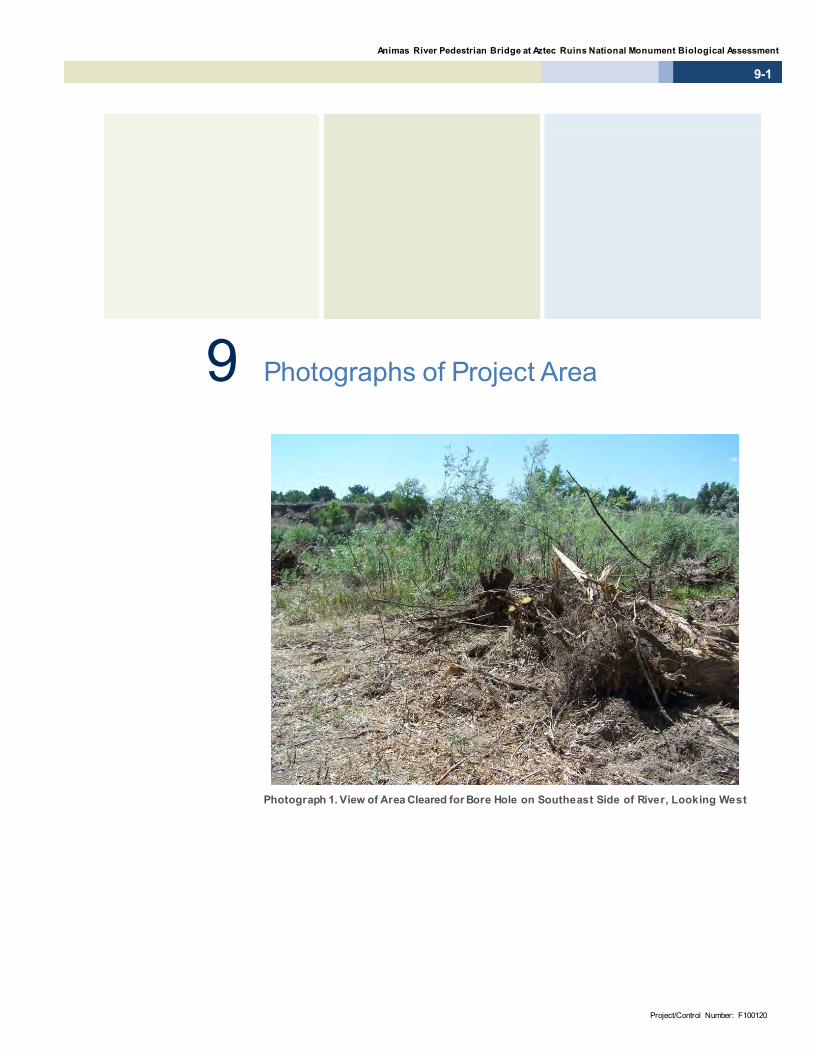
Animas River Pedestrian Bridge at Aztec Ruins National Monument Biological Assessment
9-1
Project/Control Number: F100120
9 Photographs of Project Area
Photograph 1. View of Area Cleared for Bore Hole on Southeast Side of River, Looking West

City of Aztec | September 2012
9-2
Photograph 2. Cottonwood Tree on West Side of River
Photograph 3. View of Area Cleared for Bridge Bore Hole on Northwest
Side of River, Looking East

Animas River Pedestrian Bridge at Aztec Ruins National Monument Biological Assessment
9-3
Project/Control Number: F100120
Photograph 4. Coyote Willows on Northwest Side of River, Looking West
Photograph 5. View of Animas River from Northwest Bank, Looking Southeas t
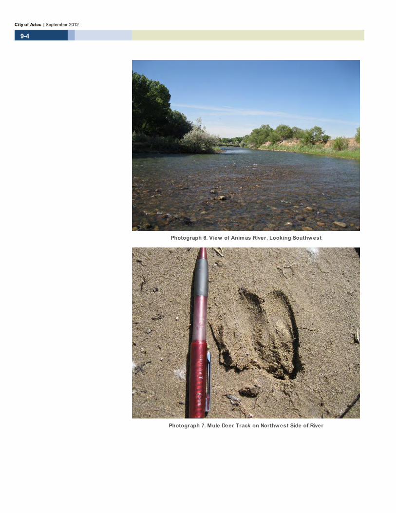
City of Aztec | September 2012
9-4
Photograph 6. View of Animas River, Looking Southwest
Photograph 7. Mule Deer Track on Northwest Side of River
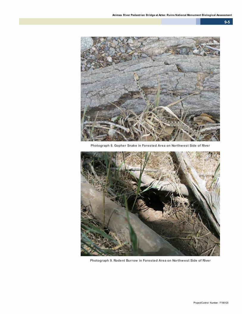
Animas River Pedestrian Bridge at Aztec Ruins National Monument Biological Assessment
9-5
Project/Control Number: F100120
Photograph 8. Gopher Snake in Forested Area on Northwest Side of River
Photograph 9. Rodent Burrow in Forested Area on Northwest Side of River

City of Aztec | September 2012
9-6
This page intentionally left blank.

Animas River Pedestrian Bridge at Aztec Ruins National Monument
10-1
Project/Control Number: F100120
10 References Cully, Anne and Paul J. Knight. 1987. A Handbook of Vegetation Maps of New
Mexico Counties. New Mexico Natural Resources Department. 135 pp.
Cunningham, K.K. 2012. Personal communication [letter] of July 25, 2012. Assistant Chief, Technical Guidance Section, Conservation Services Division, State of New Mexico Department of Game & Fish.
Dick-Peddie, William A. 1993. New Mexico Vegetation: Past, Present, and Future. University of New Mexico Press, Albuquerque.
DOI BLM (U.S. Department of the Interior, Bureau of Land Management, Taos Field Office). 2003. Environmental Assessment for the Esperanza Allotment #561 and Rio Nutrias Allotment #579, Analysis of Allotment Management Plan for Grazing Permit Renewal. May 2003.
DOI NPS (U.S. Department of the Interior, National Park Service). 2010. General Management Plan and Environmental Assessment, Aztec Ruins National Monument New Mexico.
EPA (Environmental Protection Agency). 2001. Office of Wetlands, Oceans, and Watersheds. Functions and Values of Wetlands. Available online at: <http://www.epa.gov/owow/wetlands/pdf/fun_val.pdf>. Accessed August 20, 2012.
Ferris, Clifford D. and Richard W. Holland. 1980. Bulletin of the Allyn Museum. Two New Subspecies of Occidryas Anicia from New Mexico. The Allyn Museum of Entomology, Sarasota, Florida.

City of Aztec | September 2012
10-2
Flora of North America Editorial Committee, eds. 1993+. Flora of North America North of Mexico. 16+ vols. New York and Oxford. Vol. 1, 1993; vol. 2, 1993; vol. 3, 1997; vol. 4, 2003; vol. 5, 2005; vol. 7, 2010; vol. 8, 2009; vol. 19, 2006; vol. 20, 2006; vol. 21, 2006; vol. 22, 2000; vol. 23, 2002; vol. 24, 2007; vol. 25, 2003; vol. 26, 2002; vol. 27, 2007. Available online at <www.eFloras.org>. Accessed August 9, 2012.
Hawley, John W. 1986. Physiographic Provinces I. In New Mexico in Maps, edited by John L. Williams, pp. 23–25. Second Edition, University of New Mexico Press, Albuquerque.
Maker, Harry J., and Leroy A. Daugherty. 1986. Soils. In New Mexico in Maps, edited by John L. Williams, pp. 64-66. Second Edition, University of New Mexico Press, Albuquerque.
NMDA (New Mexico Department of Agriculture). 2009. New Mexico Noxious Weed List Update. Memorandum: April 1, 2009. New Mexico State University, Las Cruces, NM.
NMDGF BISON-M (New Mexico Department of Game and Fish. Biota Information System of New Mexico). 2011. New Mexico Wildlife of Concern: Status and Distribution. Available online at <http://www.bison-m.org/index.aspx>. Accessed June 27, 2012.
NMDOT (New Mexico Department of Transportation). 2000a. Location Study Procedures, a Guidebook for Alignment and Corridor Studies. Santa Fe, NM: NMDOT Engineering Design Division, Preliminary Design Bureau.
NMDOT (New Mexico Department of Transportation). 2000b. Noxious Weed Management Guidelines. Santa Fe, NM: NMDOT Environmental Section.
NMRPTC (New Mexico Rare Plant Technical Council). 1999. New Mexico Rare Plants. Albuquerque, NM: New Mexico Rare Plants Home Page. Available online at <http://nmrareplants.unm.edu> (Last update: 30 March 2012). Accessed June 27, 2012.
Propst, D.L. 1999. Threatened and Endangered Fishes of New Mexico. Technical Report No. 1, New Mexico Department of Game and Fish, Santa Fe, NM. 84 pp.
Soil Survey Staff, Natural Resources Conservation Service, United States Department of Agriculture. 2012. Web Soil Survey. Available online at <http://websoilsurvey.nrcs.usda.gov/app>. Accessed June 27, 2012.

Animas River Pedestrian Bridge at Aztec Ruins National Monument
10-3
Project/Control Number: F100120
USACE (United States Army Corps of Engineers). 2008. Regional Supplement to the Corps of Engineers Wetland Delineation Manual: Arid West Region. USACE Engineer Research and Development Center. ERDC/EL TR-08-28.
USDA (United States Department of Agriculture). NRCS National Plant Database. New Mexico Noxious Weeds. Available online at <http://plants.usda.gov/java/ noxious?rptType= State&sort=noxComname&statefips=35>. Accessed April 2, 2012.
USFWS (United States Fish and Wildlife Service). 2012. Critical Habitat Mapper. Available online at <http://criticalhabitat.fws.gov/>. Accessed June 27, 2012.
USFWS (United States Fish and Wildlife Service). 2010. New Mexico Listed and Sensitive Species List. Available online at <http://www.fws.gov/southwest/es/ NewMexico/SBC.cfm>. Accessed June 27, 2012.
Wetland Training Institute. 2001. Field Guide for Wetland Delineation: 1987 Corps of Engineers Manual. Glenwood, NM. WTI 01-2. 143 pp.
WRCC (Western Regional Climate Center). 2012. Western United States Climate Historical Summaries. Electronic data. Available online at <http://www.wrcc. dri.edu/Climsum.html>. Accessed May 18, 2012.
Hill, Debra. 2012. Personal communication of March 19, 2012. U.S. Fish and Wildlife Service, New Mexico Ecological Services Field Office.

City of Aztec | September 2012
10-4
This page intentionally left blank.

Appendix A Species Lists


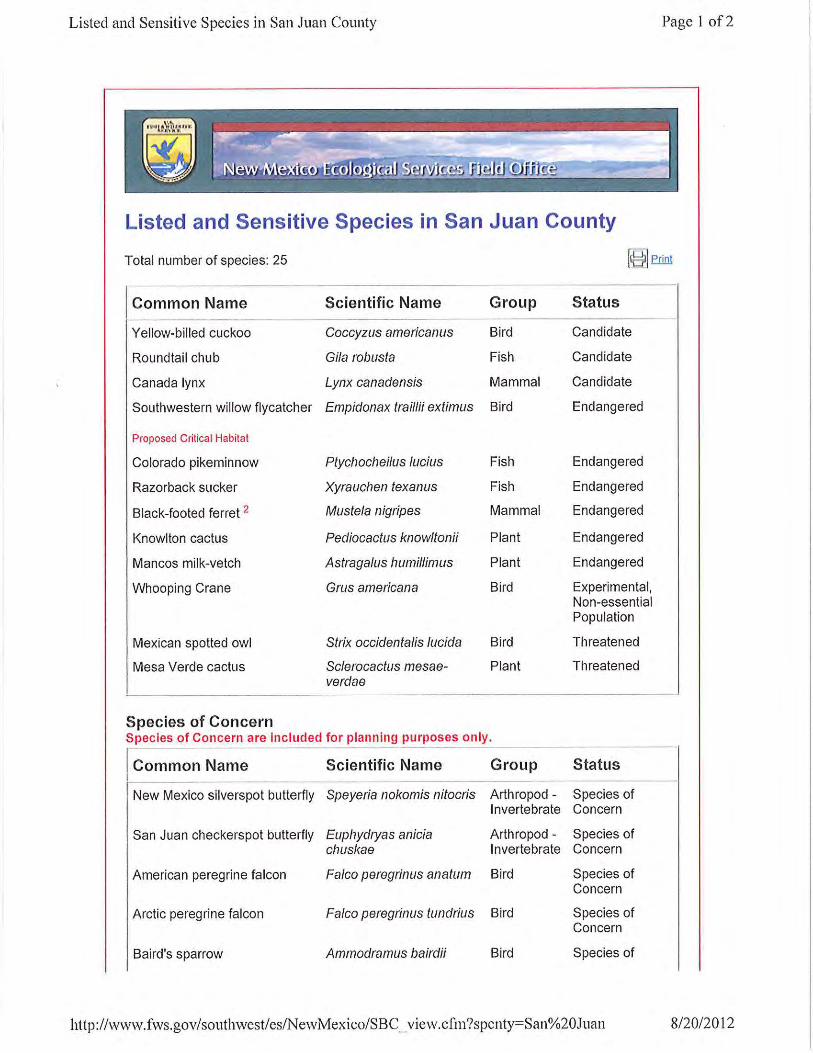


Appendix B NMRPTC List
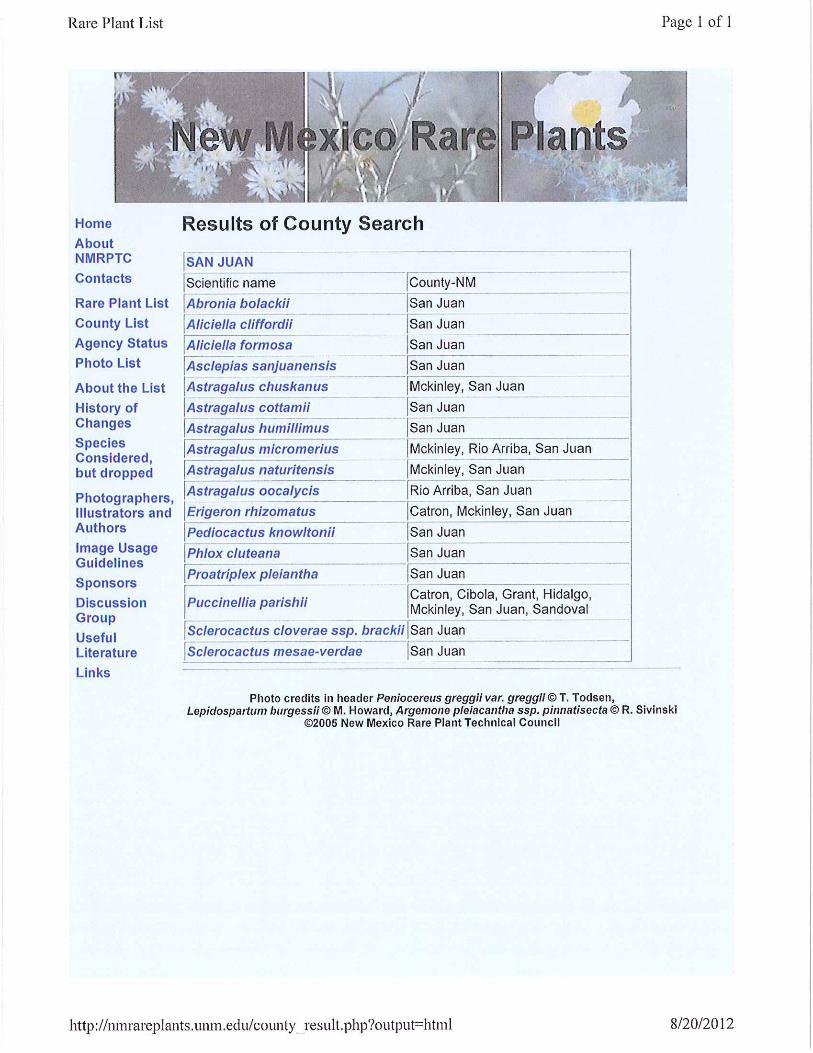

Appendix C Soil Report
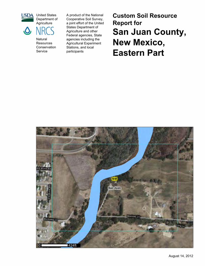
United StatesDepartment ofAgriculture
A product of the NationalCooperative Soil Survey,a joint effort of the UnitedStates Department ofAgriculture and otherFederal agencies, Stateagencies including theAgricultural ExperimentStations, and localparticipants
Custom Soil ResourceReport forSan Juan County,New Mexico,Eastern Part
NaturalResourcesConservationService
August 14, 2012

PrefaceSoil surveys contain information that affects land use planning in survey areas. Theyhighlight soil limitations that affect various land uses and provide information aboutthe properties of the soils in the survey areas. Soil surveys are designed for manydifferent users, including farmers, ranchers, foresters, agronomists, urban planners,community officials, engineers, developers, builders, and home buyers. Also,conservationists, teachers, students, and specialists in recreation, waste disposal,and pollution control can use the surveys to help them understand, protect, or enhancethe environment.
Various land use regulations of Federal, State, and local governments may imposespecial restrictions on land use or land treatment. Soil surveys identify soil propertiesthat are used in making various land use or land treatment decisions. The informationis intended to help the land users identify and reduce the effects of soil limitations onvarious land uses. The landowner or user is responsible for identifying and complyingwith existing laws and regulations.
Although soil survey information can be used for general farm, local, and wider areaplanning, onsite investigation is needed to supplement this information in some cases.Examples include soil quality assessments (http://soils.usda.gov/sqi/) and certainconservation and engineering applications. For more detailed information, contactyour local USDA Service Center (http://offices.sc.egov.usda.gov/locator/app?agency=nrcs) or your NRCS State Soil Scientist (http://soils.usda.gov/contact/state_offices/).
Great differences in soil properties can occur within short distances. Some soils areseasonally wet or subject to flooding. Some are too unstable to be used as afoundation for buildings or roads. Clayey or wet soils are poorly suited to use as septictank absorption fields. A high water table makes a soil poorly suited to basements orunderground installations.
The National Cooperative Soil Survey is a joint effort of the United States Departmentof Agriculture and other Federal agencies, State agencies including the AgriculturalExperiment Stations, and local agencies. The Natural Resources ConservationService (NRCS) has leadership for the Federal part of the National Cooperative SoilSurvey.
Information about soils is updated periodically. Updated information is availablethrough the NRCS Soil Data Mart Web site or the NRCS Web Soil Survey. The SoilData Mart is the data storage site for the official soil survey information.
The U.S. Department of Agriculture (USDA) prohibits discrimination in all its programsand activities on the basis of race, color, national origin, age, disability, and whereapplicable, sex, marital status, familial status, parental status, religion, sexualorientation, genetic information, political beliefs, reprisal, or because all or a part of anindividual's income is derived from any public assistance program. (Not all prohibitedbases apply to all programs.) Persons with disabilities who require alternative means
2

for communication of program information (Braille, large print, audiotape, etc.) shouldcontact USDA's TARGET Center at (202) 720-2600 (voice and TDD). To file acomplaint of discrimination, write to USDA, Director, Office of Civil Rights, 1400Independence Avenue, S.W., Washington, D.C. 20250-9410 or call (800) 795-3272(voice) or (202) 720-6382 (TDD). USDA is an equal opportunity provider andemployer.
3

ContentsPreface....................................................................................................................2How Soil Surveys Are Made..................................................................................5Soil Map..................................................................................................................7
Soil Map................................................................................................................8Legend..................................................................................................................9Map Unit Legend................................................................................................10Map Unit Descriptions........................................................................................10
San Juan County, New Mexico, Eastern Part.................................................12Bf—Beebe variant loamy sand....................................................................12FP—Fluvaquents, ponded...........................................................................12Fr—Fruitland sandy loam, 0 to 2 percent slopes.........................................13Ft—Fruitland sandy loam, wet, 0 to 2 percent slopes.................................14Fu—Fruitland loam, 1 to 3 percent slopes..................................................15Gr—Green River fine sandy loam...............................................................16RA—Riverwash...........................................................................................17Tr—Turley clay loam, 1 to 3 percent slopes................................................18Tt—Turley clay loam, wet, 0 to 2 percent slopes........................................19W—Lakes, rivers, reservoirs.......................................................................20Wa—Walrees loam.....................................................................................20Wr—Werlog loam........................................................................................21
References............................................................................................................23
4

How Soil Surveys Are MadeSoil surveys are made to provide information about the soils and miscellaneous areasin a specific area. They include a description of the soils and miscellaneous areas andtheir location on the landscape and tables that show soil properties and limitationsaffecting various uses. Soil scientists observed the steepness, length, and shape ofthe slopes; the general pattern of drainage; the kinds of crops and native plants; andthe kinds of bedrock. They observed and described many soil profiles. A soil profile isthe sequence of natural layers, or horizons, in a soil. The profile extends from thesurface down into the unconsolidated material in which the soil formed or from thesurface down to bedrock. The unconsolidated material is devoid of roots and otherliving organisms and has not been changed by other biological activity.
Currently, soils are mapped according to the boundaries of major land resource areas(MLRAs). MLRAs are geographically associated land resource units that sharecommon characteristics related to physiography, geology, climate, water resources,soils, biological resources, and land uses (USDA, 2006). Soil survey areas typicallyconsist of parts of one or more MLRA.
The soils and miscellaneous areas in a survey area occur in an orderly pattern that isrelated to the geology, landforms, relief, climate, and natural vegetation of the area.Each kind of soil and miscellaneous area is associated with a particular kind oflandform or with a segment of the landform. By observing the soils and miscellaneousareas in the survey area and relating their position to specific segments of thelandform, a soil scientist develops a concept, or model, of how they were formed. Thus,during mapping, this model enables the soil scientist to predict with a considerabledegree of accuracy the kind of soil or miscellaneous area at a specific location on thelandscape.
Commonly, individual soils on the landscape merge into one another as theircharacteristics gradually change. To construct an accurate soil map, however, soilscientists must determine the boundaries between the soils. They can observe onlya limited number of soil profiles. Nevertheless, these observations, supplemented byan understanding of the soil-vegetation-landscape relationship, are sufficient to verifypredictions of the kinds of soil in an area and to determine the boundaries.
Soil scientists recorded the characteristics of the soil profiles that they studied. Theynoted soil color, texture, size and shape of soil aggregates, kind and amount of rockfragments, distribution of plant roots, reaction, and other features that enable them toidentify soils. After describing the soils in the survey area and determining theirproperties, the soil scientists assigned the soils to taxonomic classes (units).Taxonomic classes are concepts. Each taxonomic class has a set of soilcharacteristics with precisely defined limits. The classes are used as a basis forcomparison to classify soils systematically. Soil taxonomy, the system of taxonomicclassification used in the United States, is based mainly on the kind and character ofsoil properties and the arrangement of horizons within the profile. After the soilscientists classified and named the soils in the survey area, they compared the
5

individual soils with similar soils in the same taxonomic class in other areas so thatthey could confirm data and assemble additional data based on experience andresearch.
The objective of soil mapping is not to delineate pure map unit components; theobjective is to separate the landscape into landforms or landform segments that havesimilar use and management requirements. Each map unit is defined by a uniquecombination of soil components and/or miscellaneous areas in predictableproportions. Some components may be highly contrasting to the other components ofthe map unit. The presence of minor components in a map unit in no way diminishesthe usefulness or accuracy of the data. The delineation of such landforms andlandform segments on the map provides sufficient information for the development ofresource plans. If intensive use of small areas is planned, onsite investigation isneeded to define and locate the soils and miscellaneous areas.
Soil scientists make many field observations in the process of producing a soil map.The frequency of observation is dependent upon several factors, including scale ofmapping, intensity of mapping, design of map units, complexity of the landscape, andexperience of the soil scientist. Observations are made to test and refine the soil-landscape model and predictions and to verify the classification of the soils at specificlocations. Once the soil-landscape model is refined, a significantly smaller number ofmeasurements of individual soil properties are made and recorded. Thesemeasurements may include field measurements, such as those for color, depth tobedrock, and texture, and laboratory measurements, such as those for content ofsand, silt, clay, salt, and other components. Properties of each soil typically vary fromone point to another across the landscape.
Observations for map unit components are aggregated to develop ranges ofcharacteristics for the components. The aggregated values are presented. Directmeasurements do not exist for every property presented for every map unitcomponent. Values for some properties are estimated from combinations of otherproperties.
While a soil survey is in progress, samples of some of the soils in the area generallyare collected for laboratory analyses and for engineering tests. Soil scientists interpretthe data from these analyses and tests as well as the field-observed characteristicsand the soil properties to determine the expected behavior of the soils under differentuses. Interpretations for all of the soils are field tested through observation of the soilsin different uses and under different levels of management. Some interpretations aremodified to fit local conditions, and some new interpretations are developed to meetlocal needs. Data are assembled from other sources, such as research information,production records, and field experience of specialists. For example, data on cropyields under defined levels of management are assembled from farm records and fromfield or plot experiments on the same kinds of soil.
Predictions about soil behavior are based not only on soil properties but also on suchvariables as climate and biological activity. Soil conditions are predictable over longperiods of time, but they are not predictable from year to year. For example, soilscientists can predict with a fairly high degree of accuracy that a given soil will havea high water table within certain depths in most years, but they cannot predict that ahigh water table will always be at a specific level in the soil on a specific date.
After soil scientists located and identified the significant natural bodies of soil in thesurvey area, they drew the boundaries of these bodies on aerial photographs andidentified each as a specific map unit. Aerial photographs show trees, buildings, fields,roads, and rivers, all of which help in locating boundaries accurately.
Custom Soil Resource Report
6

Soil MapThe soil map section includes the soil map for the defined area of interest, a list of soilmap units on the map and extent of each map unit, and cartographic symbolsdisplayed on the map. Also presented are various metadata about data used toproduce the map, and a description of each soil map unit.
7
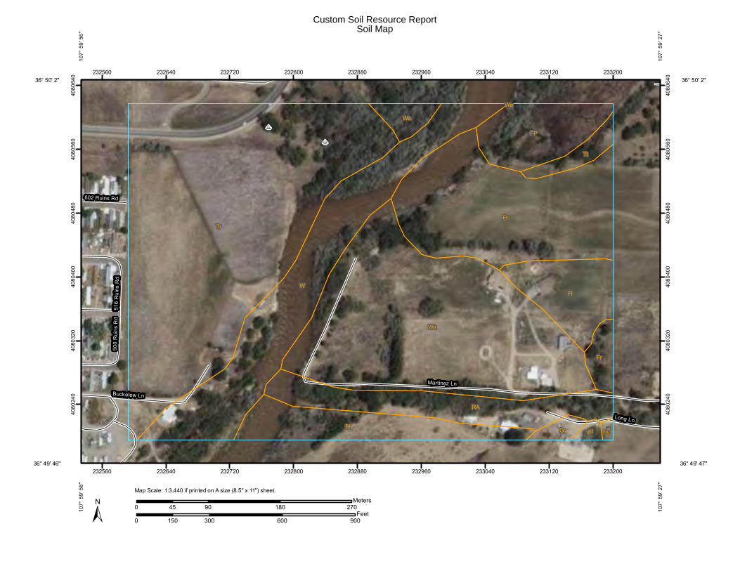
+
+
Martinez Ln
Long Ln
Buckelew Ln
516
Rui
ns R
d50
0 R
uins
Rd
602 Ruins Rd
Tr
Wa
Fr
W
Bf
RA
Ft
FP
Tt
Fr
Wa
Gr Wr Fu
Wa
232560
232560
232640
232640
232720
232720
232800
232800
232880
232880
232960
232960
233040
233040
233120
233120
233200
233200
4080
240
4080
240
4080
320
4080
320
4080
400
4080
400
4080
480
4080
480
4080
560
4080
560
4080
640
4080
640
0 300 600 900150Feet
0 90 180 27045Meters
±
36° 50' 2''
107°
59'
27'
'
36° 49' 47''
107°
59'
27'
'
36° 49' 46''
36° 50' 2''10
7° 5
9' 5
6''
107°
59'
56'
'
Map Scale: 1:3,440 if printed on A size (8.5" x 11") sheet.
Custom Soil Resource ReportSoil Map

MAP LEGEND MAP INFORMATION
Area of Interest (AOI)Area of Interest (AOI)
SoilsSoil Map Units
Special Point FeaturesBlowout
Borrow Pit
Clay Spot
Closed Depression
Gravel Pit
Gravelly Spot
Landfill
Lava Flow
Marsh or swamp
Mine or Quarry
Miscellaneous Water
Perennial Water
Rock Outcrop
Saline Spot
Sandy Spot
Severely Eroded Spot
Sinkhole
Slide or Slip
Sodic Spot
Spoil Area
Stony Spot
Very Stony Spot
Wet Spot
Other
Special Line FeaturesGully
Short Steep Slope
Other
Political FeaturesCities
Water FeaturesStreams and Canals
TransportationRails
Interstate Highways
US Routes
Major Roads
Local Roads
Map Scale: 1:3,440 if printed on A size (8.5" × 11") sheet.
The soil surveys that comprise your AOI were mapped at 1:63,360.
Warning: Soil Map may not be valid at this scale.
Enlargement of maps beyond the scale of mapping can causemisunderstanding of the detail of mapping and accuracy of soil lineplacement. The maps do not show the small areas of contrastingsoils that could have been shown at a more detailed scale.
Please rely on the bar scale on each map sheet for accurate mapmeasurements.
Source of Map: Natural Resources Conservation ServiceWeb Soil Survey URL: http://websoilsurvey.nrcs.usda.govCoordinate System: UTM Zone 13N NAD83
This product is generated from the USDA-NRCS certified data as ofthe version date(s) listed below.
Soil Survey Area: San Juan County, New Mexico, Eastern PartSurvey Area Data: Version 10, Sep 23, 2009
Date(s) aerial images were photographed: Data not available.
The orthophoto or other base map on which the soil lines werecompiled and digitized probably differs from the backgroundimagery displayed on these maps. As a result, some minor shiftingof map unit boundaries may be evident.
Custom Soil Resource Report
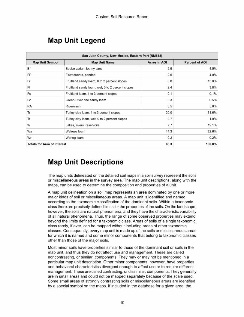
Map Unit Legend
San Juan County, New Mexico, Eastern Part (NM618)
Map Unit Symbol Map Unit Name Acres in AOI Percent of AOI
Bf Beebe variant loamy sand 2.9 4.5%
FP Fluvaquents, ponded 2.5 4.0%
Fr Fruitland sandy loam, 0 to 2 percent slopes 8.8 13.8%
Ft Fruitland sandy loam, wet, 0 to 2 percent slopes 2.4 3.8%
Fu Fruitland loam, 1 to 3 percent slopes 0.1 0.1%
Gr Green River fine sandy loam 0.3 0.5%
RA Riverwash 3.5 5.6%
Tr Turley clay loam, 1 to 3 percent slopes 20.0 31.6%
Tt Turley clay loam, wet, 0 to 2 percent slopes 0.7 1.0%
W Lakes, rivers, reservoirs 7.7 12.1%
Wa Walrees loam 14.3 22.6%
Wr Werlog loam 0.2 0.2%
Totals for Area of Interest 63.3 100.0%
Map Unit DescriptionsThe map units delineated on the detailed soil maps in a soil survey represent the soilsor miscellaneous areas in the survey area. The map unit descriptions, along with themaps, can be used to determine the composition and properties of a unit.
A map unit delineation on a soil map represents an area dominated by one or moremajor kinds of soil or miscellaneous areas. A map unit is identified and namedaccording to the taxonomic classification of the dominant soils. Within a taxonomicclass there are precisely defined limits for the properties of the soils. On the landscape,however, the soils are natural phenomena, and they have the characteristic variabilityof all natural phenomena. Thus, the range of some observed properties may extendbeyond the limits defined for a taxonomic class. Areas of soils of a single taxonomicclass rarely, if ever, can be mapped without including areas of other taxonomicclasses. Consequently, every map unit is made up of the soils or miscellaneous areasfor which it is named and some minor components that belong to taxonomic classesother than those of the major soils.
Most minor soils have properties similar to those of the dominant soil or soils in themap unit, and thus they do not affect use and management. These are callednoncontrasting, or similar, components. They may or may not be mentioned in aparticular map unit description. Other minor components, however, have propertiesand behavioral characteristics divergent enough to affect use or to require differentmanagement. These are called contrasting, or dissimilar, components. They generallyare in small areas and could not be mapped separately because of the scale used.Some small areas of strongly contrasting soils or miscellaneous areas are identifiedby a special symbol on the maps. If included in the database for a given area, the
Custom Soil Resource Report
10

contrasting minor components are identified in the map unit descriptions along withsome characteristics of each. A few areas of minor components may not have beenobserved, and consequently they are not mentioned in the descriptions, especiallywhere the pattern was so complex that it was impractical to make enough observationsto identify all the soils and miscellaneous areas on the landscape.
The presence of minor components in a map unit in no way diminishes the usefulnessor accuracy of the data. The objective of mapping is not to delineate pure taxonomicclasses but rather to separate the landscape into landforms or landform segments thathave similar use and management requirements. The delineation of such segmentson the map provides sufficient information for the development of resource plans. Ifintensive use of small areas is planned, however, onsite investigation is needed todefine and locate the soils and miscellaneous areas.
An identifying symbol precedes the map unit name in the map unit descriptions. Eachdescription includes general facts about the unit and gives important soil propertiesand qualities.
Soils that have profiles that are almost alike make up a soil series. Except fordifferences in texture of the surface layer, all the soils of a series have major horizonsthat are similar in composition, thickness, and arrangement.
Soils of one series can differ in texture of the surface layer, slope, stoniness, salinity,degree of erosion, and other characteristics that affect their use. On the basis of suchdifferences, a soil series is divided into soil phases. Most of the areas shown on thedetailed soil maps are phases of soil series. The name of a soil phase commonlyindicates a feature that affects use or management. For example, Alpha silt loam, 0to 2 percent slopes, is a phase of the Alpha series.
Some map units are made up of two or more major soils or miscellaneous areas.These map units are complexes, associations, or undifferentiated groups.
A complex consists of two or more soils or miscellaneous areas in such an intricatepattern or in such small areas that they cannot be shown separately on the maps. Thepattern and proportion of the soils or miscellaneous areas are somewhat similar in allareas. Alpha-Beta complex, 0 to 6 percent slopes, is an example.
An association is made up of two or more geographically associated soils ormiscellaneous areas that are shown as one unit on the maps. Because of present oranticipated uses of the map units in the survey area, it was not considered practicalor necessary to map the soils or miscellaneous areas separately. The pattern andrelative proportion of the soils or miscellaneous areas are somewhat similar. Alpha-Beta association, 0 to 2 percent slopes, is an example.
An undifferentiated group is made up of two or more soils or miscellaneous areas thatcould be mapped individually but are mapped as one unit because similarinterpretations can be made for use and management. The pattern and proportion ofthe soils or miscellaneous areas in a mapped area are not uniform. An area can bemade up of only one of the major soils or miscellaneous areas, or it can be made upof all of them. Alpha and Beta soils, 0 to 2 percent slopes, is an example.
Some surveys include miscellaneous areas. Such areas have little or no soil materialand support little or no vegetation. Rock outcrop is an example.
Custom Soil Resource Report
11

San Juan County, New Mexico, Eastern Part
Bf—Beebe variant loamy sand
Map Unit SettingElevation: 4,800 to 6,000 feetMean annual precipitation: 6 to 10 inchesMean annual air temperature: 51 to 55 degrees FFrost-free period: 140 to 160 days
Map Unit CompositionBeebe variant and similar soils: 85 percent
Description of Beebe Variant
SettingLandform: Flood plainsLandform position (three-dimensional): TalfDown-slope shape: LinearAcross-slope shape: LinearParent material: Stream alluvium derived from igneous and sedimentary rock
Properties and qualitiesSlope: 0 to 2 percentDepth to restrictive feature: More than 80 inchesDrainage class: Somewhat poorly drainedCapacity of the most limiting layer to transmit water (Ksat): High to very high (6.00
to 20.00 in/hr)Depth to water table: About 24 to 60 inchesFrequency of flooding: FrequentFrequency of ponding: NoneCalcium carbonate, maximum content: 1 percentMaximum salinity: Nonsaline to very slightly saline (2.0 to 4.0 mmhos/cm)Available water capacity: Low (about 4.3 inches)
Interpretive groupsLand capability classification (irrigated): 4wLand capability (nonirrigated): 6wEcological site: Sandy (R035XB002NM)
Typical profile0 to 8 inches: Loamy sand8 to 67 inches: Sand67 to 81 inches: Very gravelly sand
FP—Fluvaquents, ponded
Map Unit SettingElevation: 4,800 to 6,000 feetMean annual precipitation: 6 to 10 inchesMean annual air temperature: 51 to 55 degrees F
Custom Soil Resource Report
12
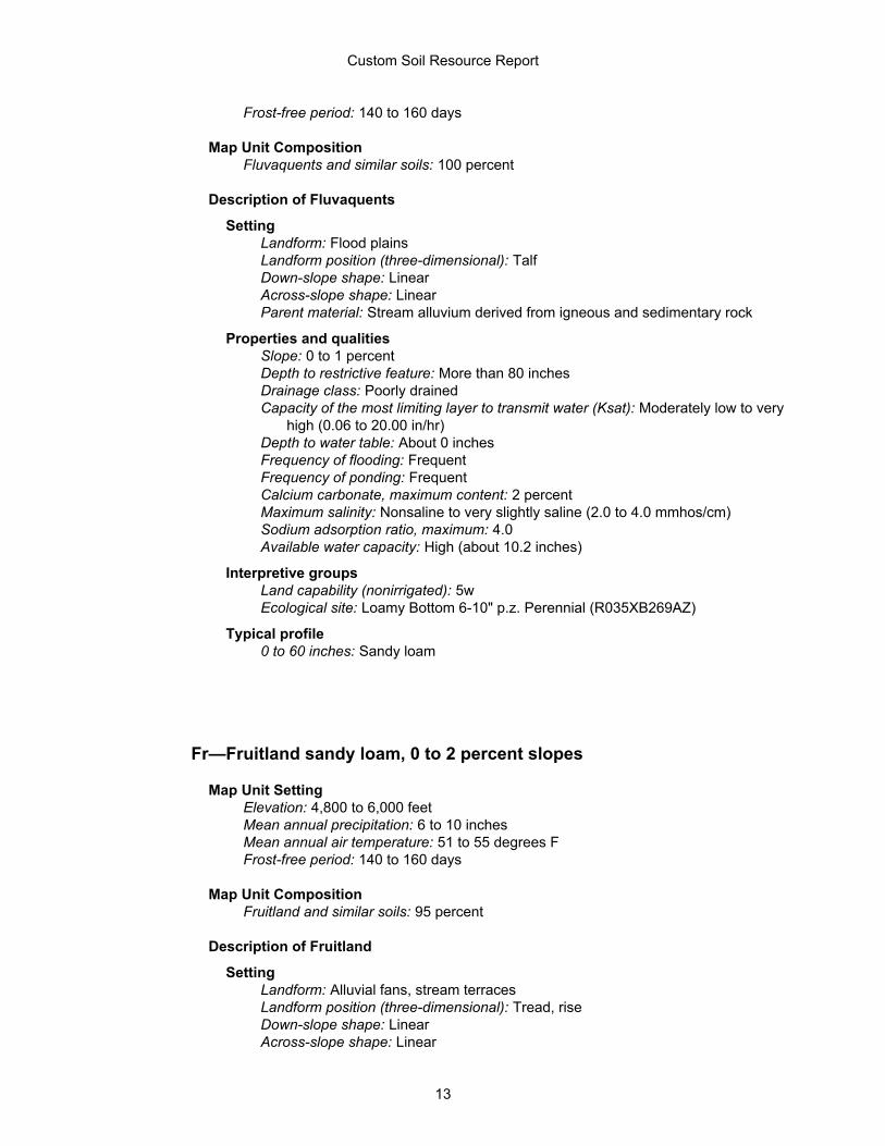
Frost-free period: 140 to 160 days
Map Unit CompositionFluvaquents and similar soils: 100 percent
Description of Fluvaquents
SettingLandform: Flood plainsLandform position (three-dimensional): TalfDown-slope shape: LinearAcross-slope shape: LinearParent material: Stream alluvium derived from igneous and sedimentary rock
Properties and qualitiesSlope: 0 to 1 percentDepth to restrictive feature: More than 80 inchesDrainage class: Poorly drainedCapacity of the most limiting layer to transmit water (Ksat): Moderately low to very
high (0.06 to 20.00 in/hr)Depth to water table: About 0 inchesFrequency of flooding: FrequentFrequency of ponding: FrequentCalcium carbonate, maximum content: 2 percentMaximum salinity: Nonsaline to very slightly saline (2.0 to 4.0 mmhos/cm)Sodium adsorption ratio, maximum: 4.0Available water capacity: High (about 10.2 inches)
Interpretive groupsLand capability (nonirrigated): 5wEcological site: Loamy Bottom 6-10" p.z. Perennial (R035XB269AZ)
Typical profile0 to 60 inches: Sandy loam
Fr—Fruitland sandy loam, 0 to 2 percent slopes
Map Unit SettingElevation: 4,800 to 6,000 feetMean annual precipitation: 6 to 10 inchesMean annual air temperature: 51 to 55 degrees FFrost-free period: 140 to 160 days
Map Unit CompositionFruitland and similar soils: 95 percent
Description of Fruitland
SettingLandform: Alluvial fans, stream terracesLandform position (three-dimensional): Tread, riseDown-slope shape: LinearAcross-slope shape: Linear
Custom Soil Resource Report
13

Parent material: Alluvium derived from sandstone and shale
Properties and qualitiesSlope: 0 to 2 percentDepth to restrictive feature: More than 80 inchesDrainage class: Well drainedCapacity of the most limiting layer to transmit water (Ksat): High (2.00 to 6.00 in/hr)Depth to water table: More than 80 inchesFrequency of flooding: NoneFrequency of ponding: NoneCalcium carbonate, maximum content: 10 percentMaximum salinity: Nonsaline to very slightly saline (0.0 to 4.0 mmhos/cm)Sodium adsorption ratio, maximum: 2.0Available water capacity: Moderate (about 7.2 inches)
Interpretive groupsLand capability classification (irrigated): 2eLand capability (nonirrigated): 7eEcological site: Sandy (R035XB002NM)
Typical profile0 to 7 inches: Sandy loam7 to 60 inches: Fine sandy loam
Ft—Fruitland sandy loam, wet, 0 to 2 percent slopes
Map Unit SettingElevation: 4,800 to 6,400 feetMean annual precipitation: 6 to 10 inchesMean annual air temperature: 51 to 55 degrees FFrost-free period: 140 to 160 days
Map Unit CompositionFruitland variant and similar soils: 90 percent
Description of Fruitland Variant
SettingLandform: Alluvial fans, stream terracesLandform position (three-dimensional): Tread, riseDown-slope shape: LinearAcross-slope shape: LinearParent material: Alluvium derived from sandstone and shale
Properties and qualitiesSlope: 0 to 2 percentDepth to restrictive feature: More than 80 inchesDrainage class: Well drainedCapacity of the most limiting layer to transmit water (Ksat): High (2.00 to 6.00 in/hr)Depth to water table: About 24 to 60 inchesFrequency of flooding: NoneFrequency of ponding: NoneCalcium carbonate, maximum content: 2 percent
Custom Soil Resource Report
14

Maximum salinity: Nonsaline to very slightly saline (0.0 to 4.0 mmhos/cm)Sodium adsorption ratio, maximum: 2.0Available water capacity: Moderate (about 6.6 inches)
Interpretive groupsLand capability classification (irrigated): 2wLand capability (nonirrigated): 6wEcological site: Sandy (R035XB002NM)
Typical profile0 to 6 inches: Sandy loam6 to 60 inches: Sandy loam
Fu—Fruitland loam, 1 to 3 percent slopes
Map Unit SettingElevation: 4,800 to 6,000 feetMean annual precipitation: 6 to 10 inchesMean annual air temperature: 51 to 55 degrees FFrost-free period: 140 to 160 days
Map Unit CompositionFruitland and similar soils: 95 percent
Description of Fruitland
SettingLandform: Alluvial fans, stream terracesLandform position (three-dimensional): Tread, riseDown-slope shape: LinearAcross-slope shape: LinearParent material: Alluvium derived from sandstone and shale
Properties and qualitiesSlope: 1 to 3 percentDepth to restrictive feature: More than 80 inchesDrainage class: Well drainedCapacity of the most limiting layer to transmit water (Ksat): Moderately high to high
(0.60 to 2.00 in/hr)Depth to water table: More than 80 inchesFrequency of flooding: NoneFrequency of ponding: NoneCalcium carbonate, maximum content: 10 percentGypsum, maximum content: 1 percentMaximum salinity: Nonsaline to very slightly saline (0.0 to 4.0 mmhos/cm)Sodium adsorption ratio, maximum: 2.0Available water capacity: Moderate (about 7.5 inches)
Interpretive groupsLand capability classification (irrigated): 2eLand capability (nonirrigated): 7eEcological site: Loamy (R035XB001NM)
Custom Soil Resource Report
15
Typical profile0 to 8 inches: Loam8 to 60 inches: Sandy loam
Gr—Green River fine sandy loam
Map Unit SettingElevation: 4,800 to 6,000 feetMean annual precipitation: 6 to 10 inchesMean annual air temperature: 51 to 55 degrees FFrost-free period: 140 to 160 days
Map Unit CompositionGreen river and similar soils: 90 percent
Description of Green River
SettingLandform: Flood plainsLandform position (three-dimensional): TalfDown-slope shape: LinearAcross-slope shape: LinearParent material: Stream alluvium derived from igneous and sedimentary rock
Properties and qualitiesSlope: 0 to 1 percentDepth to restrictive feature: More than 80 inchesDrainage class: Somewhat poorly drainedCapacity of the most limiting layer to transmit water (Ksat): Moderately high to high
(0.60 to 2.00 in/hr)Depth to water table: About 24 to 60 inchesFrequency of flooding: OccasionalFrequency of ponding: NoneCalcium carbonate, maximum content: 1 percentMaximum salinity: Nonsaline to slightly saline (2.0 to 8.0 mmhos/cm)Available water capacity: Moderate (about 6.5 inches)
Interpretive groupsLand capability classification (irrigated): 2wLand capability (nonirrigated): 6wEcological site: Shale Hills (R035XB009NM)
Typical profile0 to 6 inches: Fine sandy loam6 to 60 inches: Stratified fine sandy loam to loam
Custom Soil Resource Report
16
RA—Riverwash
Map Unit SettingElevation: 4,800 to 6,400 feetMean annual precipitation: 6 to 10 inchesMean annual air temperature: 51 to 55 degrees FFrost-free period: 140 to 160 days
Map Unit CompositionRiverwash, clayey: 35 percentRiverwash, sandy: 35 percentRiverwash, gravelly: 30 percent
Description of Riverwash, Sandy
SettingLandform: Flood plainsLandform position (three-dimensional): TalfDown-slope shape: LinearAcross-slope shape: LinearParent material: Stream alluvium derived from igneous and sedimentary rock
Properties and qualitiesSlope: 0 to 3 percentDrainage class: Poorly drainedCapacity of the most limiting layer to transmit water (Ksat): High to very high (6.00
to 20.00 in/hr)Depth to water table: About 0 to 24 inchesFrequency of flooding: FrequentAvailable water capacity: Very low (about 2.9 inches)
Interpretive groupsLand capability (nonirrigated): 8w
Typical profile0 to 6 inches: Sand6 to 60 inches: Stratified coarse sand to sandy loam
Description of Riverwash, Clayey
SettingLandform: Flood plainsLandform position (three-dimensional): TalfDown-slope shape: LinearAcross-slope shape: LinearParent material: Stream alluvium derived from igneous and sedimentary rock
Properties and qualitiesSlope: 0 to 1 percentDrainage class: Poorly drainedCapacity of the most limiting layer to transmit water (Ksat): Very low to moderately
high (0.00 to 0.20 in/hr)
Custom Soil Resource Report
17
Depth to water table: About 0 to 6 inchesFrequency of flooding: FrequentAvailable water capacity: Low (about 6.0 inches)
Interpretive groupsLand capability (nonirrigated): 8w
Typical profile0 to 6 inches: Clay6 to 60 inches: Clay
Description of Riverwash, Gravelly
SettingLandform: Flood plainsLandform position (three-dimensional): TalfDown-slope shape: LinearAcross-slope shape: LinearParent material: Stream alluvium derived from igneous and sedimentary rock
Properties and qualitiesSlope: 0 to 3 percentDrainage class: Poorly drainedCapacity of the most limiting layer to transmit water (Ksat): High to very high (6.00
to 20.00 in/hr)Depth to water table: About 0 to 24 inchesFrequency of flooding: FrequentAvailable water capacity: Very low (about 1.9 inches)
Interpretive groupsLand capability (nonirrigated): 8w
Typical profile0 to 6 inches: Gravelly sand6 to 60 inches: Stratified extremely gravelly coarse sand to gravelly sand
Tr—Turley clay loam, 1 to 3 percent slopes
Map Unit SettingElevation: 4,800 to 6,000 feetMean annual precipitation: 6 to 10 inchesMean annual air temperature: 51 to 55 degrees FFrost-free period: 140 to 160 days
Map Unit CompositionTurley and similar soils: 95 percent
Description of Turley
SettingLandform: Alluvial fans
Custom Soil Resource Report
18

Landform position (three-dimensional): RiseDown-slope shape: LinearAcross-slope shape: LinearParent material: Fan alluvium derived from sandstone and shale
Properties and qualitiesSlope: 1 to 3 percentDepth to restrictive feature: More than 80 inchesDrainage class: Well drainedCapacity of the most limiting layer to transmit water (Ksat): Moderately high (0.20 to
0.60 in/hr)Depth to water table: More than 80 inchesFrequency of flooding: NoneFrequency of ponding: NoneCalcium carbonate, maximum content: 5 percentMaximum salinity: Nonsaline to very slightly saline (2.0 to 4.0 mmhos/cm)Sodium adsorption ratio, maximum: 2.0Available water capacity: High (about 11.4 inches)
Interpretive groupsLand capability classification (irrigated): 2eLand capability (nonirrigated): 7eEcological site: Clayey (R035XB004NM)
Typical profile0 to 9 inches: Clay loam9 to 60 inches: Clay loam60 to 64 inches: Clay loam
Tt—Turley clay loam, wet, 0 to 2 percent slopes
Map Unit SettingElevation: 4,800 to 6,000 feetMean annual precipitation: 6 to 10 inchesMean annual air temperature: 51 to 55 degrees FFrost-free period: 140 to 160 days
Map Unit CompositionTurley variant and similar soils: 90 percent
Description of Turley Variant
SettingLandform: Alluvial fansLandform position (three-dimensional): RiseDown-slope shape: LinearAcross-slope shape: LinearParent material: Fan alluvium derived from sandstone and shale
Properties and qualitiesSlope: 0 to 2 percentDepth to restrictive feature: More than 80 inchesDrainage class: Moderately well drained
Custom Soil Resource Report
19
Capacity of the most limiting layer to transmit water (Ksat): Moderately high (0.20 to0.60 in/hr)
Depth to water table: About 24 to 60 inchesFrequency of flooding: NoneFrequency of ponding: NoneCalcium carbonate, maximum content: 5 percentGypsum, maximum content: 2 percentMaximum salinity: Nonsaline to very slightly saline (2.0 to 4.0 mmhos/cm)Sodium adsorption ratio, maximum: 2.0Available water capacity: High (about 10.2 inches)
Interpretive groupsLand capability classification (irrigated): 2wLand capability (nonirrigated): 6wEcological site: Clayey (R035XB004NM)
Typical profile0 to 9 inches: Clay loam9 to 60 inches: Clay loam
W—Lakes, rivers, reservoirs
Map Unit SettingElevation: 4,800 to 6,400 feetMean annual precipitation: 6 to 10 inchesMean annual air temperature: 51 to 55 degrees FFrost-free period: 140 to 160 days
Map Unit CompositionWater: 95 percent
Description of Water
SettingLandform: ChannelsLandform position (three-dimensional): TalfDown-slope shape: LinearAcross-slope shape: Linear
Wa—Walrees loam
Map Unit SettingElevation: 6,400 to 7,200 feetMean annual precipitation: 10 to 14 inchesMean annual air temperature: 48 to 52 degrees FFrost-free period: 125 to 145 days
Custom Soil Resource Report
20

Map Unit CompositionWalrees and similar soils: 70 percent
Description of Walrees
SettingLandform: Flood plainsLandform position (three-dimensional): TalfDown-slope shape: LinearAcross-slope shape: LinearParent material: Mixed alluvium
Properties and qualitiesSlope: 0 to 2 percentDepth to restrictive feature: More than 80 inchesDrainage class: Somewhat poorly drainedCapacity of the most limiting layer to transmit water (Ksat): Moderately high (0.20 to
0.60 in/hr)Depth to water table: About 24 to 60 inchesFrequency of flooding: OccasionalFrequency of ponding: NoneCalcium carbonate, maximum content: 2 percentMaximum salinity: Nonsaline to slightly saline (2.0 to 8.0 mmhos/cm)Available water capacity: Moderate (about 7.7 inches)
Interpretive groupsLand capability (nonirrigated): 6wEcological site: Shale Hills (R035XB009NM)
Typical profile0 to 6 inches: Loam6 to 30 inches: Loam30 to 81 inches: Stratified gravelly sand
Wr—Werlog loam
Map Unit SettingElevation: 6,400 to 7,200 feetMean annual precipitation: 10 to 14 inchesMean annual air temperature: 48 to 52 degrees FFrost-free period: 125 to 145 days
Map Unit CompositionWerlog and similar soils: 70 percent
Description of Werlog
SettingLandform: Flood plainsLandform position (three-dimensional): TalfDown-slope shape: LinearAcross-slope shape: Linear
Custom Soil Resource Report
21

Parent material: Mixed alluvium
Properties and qualitiesSlope: 0 to 1 percentDepth to restrictive feature: More than 80 inchesDrainage class: Somewhat poorly drainedCapacity of the most limiting layer to transmit water (Ksat): Moderately high (0.20 to
0.60 in/hr)Depth to water table: About 24 to 60 inchesFrequency of flooding: NoneFrequency of ponding: NoneCalcium carbonate, maximum content: 2 percentMaximum salinity: Nonsaline to very slightly saline (2.0 to 4.0 mmhos/cm)Available water capacity: High (about 10.1 inches)
Interpretive groupsLand capability classification (irrigated): 3wLand capability (nonirrigated): 6wEcological site: Loamy (R035XB001NM)
Typical profile0 to 6 inches: Loam6 to 60 inches: Stratified fine sandy loam to clay loam60 to 81 inches: Stratified sand to cobbly sand
Custom Soil Resource Report
22

ReferencesAmerican Association of State Highway and Transportation Officials (AASHTO). 2004.Standard specifications for transportation materials and methods of sampling andtesting. 24th edition.
American Society for Testing and Materials (ASTM). 2005. Standard classification ofsoils for engineering purposes. ASTM Standard D2487-00.
Cowardin, L.M., V. Carter, F.C. Golet, and E.T. LaRoe. 1979. Classification ofwetlands and deep-water habitats of the United States. U.S. Fish and Wildlife ServiceFWS/OBS-79/31.
Federal Register. July 13, 1994. Changes in hydric soils of the United States.
Federal Register. September 18, 2002. Hydric soils of the United States.
Hurt, G.W., and L.M. Vasilas, editors. Version 6.0, 2006. Field indicators of hydric soilsin the United States.
National Research Council. 1995. Wetlands: Characteristics and boundaries.
Soil Survey Division Staff. 1993. Soil survey manual. Soil Conservation Service. U.S.Department of Agriculture Handbook 18. http://soils.usda.gov/
Soil Survey Staff. 1999. Soil taxonomy: A basic system of soil classification for makingand interpreting soil surveys. 2nd edition. Natural Resources Conservation Service,U.S. Department of Agriculture Handbook 436. http://soils.usda.gov/
Soil Survey Staff. 2006. Keys to soil taxonomy. 10th edition. U.S. Department ofAgriculture, Natural Resources Conservation Service. http://soils.usda.gov/
Tiner, R.W., Jr. 1985. Wetlands of Delaware. U.S. Fish and Wildlife Service andDelaware Department of Natural Resources and Environmental Control, WetlandsSection.
United States Army Corps of Engineers, Environmental Laboratory. 1987. Corps ofEngineers wetlands delineation manual. Waterways Experiment Station TechnicalReport Y-87-1.
United States Department of Agriculture, Natural Resources Conservation Service.National forestry manual. http://soils.usda.gov/
United States Department of Agriculture, Natural Resources Conservation Service.National range and pasture handbook. http://www.glti.nrcs.usda.gov/
United States Department of Agriculture, Natural Resources Conservation Service.National soil survey handbook, title 430-VI. http://soils.usda.gov/
United States Department of Agriculture, Natural Resources Conservation Service.2006. Land resource regions and major land resource areas of the United States, theCaribbean, and the Pacific Basin. U.S. Department of Agriculture Handbook 296.http://soils.usda.gov/
23

United States Department of Agriculture, Soil Conservation Service. 1961. Landcapability classification. U.S. Department of Agriculture Handbook 210.
Custom Soil Resource Report
24

Appendix D Observed Species

Table A-1. Plants Observed for the Aztec Pedestrian Bridge Project
Scientific Name of Species Common Name Family AbundanceAcroptilon repens Russian knapweed Asteraceae abundantAmaranthus cf. hybridus Hybrid pigweed Amaranthaceae commonAmaranthus palmeri Palmer's pigweed Amaranthaceae uncommonApocynum cannabinum Indian hemp or dogbane Apocynaceae uncommonAristida purpurea Purple three-awn Poaceae commonArtemisia carruthii Carruth's sage Asteraceae uncommonArtemisia ludoviciana Louisiana sage Asteraceae uncommonAsclepias latifolia Broad-leaved milkweed Asclepiadaceae uncommonAster falcatus Heath aster Asteraceae uncommonBaccharis salicina Willow baccharis Asteraceae uncommonBouteloua curtipendula Side-oats grama Poaceae uncommonBouteloua gracilis Blue grama Poaceae commonBromus inermis Smooth brome Poaceae commonBromus tectorum Cheat grass Poaceae commonCarduus nutans Musk thistle Asteraceae uncommonCarex pellita (Carex lasiocarpa var.
latifolia) Sedge Cyperaceae uncommonChenopodium album Lamb's quarters Chenopodiaceae commonCichorium intybus Chicory Asteraceae scarceCirsium arvense Canada thistle Asteraceae commonCirsium vulgare Bull thistle Asteraceae uncommonClematis cf. ligusticifolia Western virgin's bower Ranunculaceae uncommonDactylis glomerata Orchard grass Poaceae commonDescurainia obtusa Tansy mustard Brassicaceae commonDescurainia sophia Flixweed Brassicaceae commonElaeagnus angustifolia Russian olive Elaeagnaceae commonEleocharis palustris Marsh spikerush Cyperaceae uncommonElymus (Agropyron) smithii Western wheatgrass Poaceae abundantElymus canadensis Canada wild rye Poaceae uncommonElymus hispidus subsp. hispidus Intermediate wheatgrass Poaceae uncommonEquisetum cf. laevigatum Smooth scouring rush Equisetaceae uncommonEricameria (Chrysothamnus) nauseosa Rubber rabbitbrush Asteraceae commonErodium cicutarium Red-stemmed filaree Geraniaceae uncommonFestuca arundinacea Tall fescue Poaceae commonForestiera neomexicana New Mexico olive Oleaceae uncommonGleditsia triacanthos Honey locust (thornless variety) Fabaceae scarce (ornamental)Glycyrrhiza lepidota American licorice Fabaceae uncommonGrindelia aphanactis Rayless gumweed Asteraceae commonGutierrezia sarothrae Broom snakeweed Asteraceae uncommonHelianthus annuus Common sunflower Asteraceae commonHeterotheca villosa Hairy golden aster Asteraceae uncommonJuniperus sp. Juniper Asteraceae uncommonKochia scoparia Summer cypress Chenopodiaceae commonLactuca serriola Prickly lettuce Asteraceae commonLathyrus eucosmos Wild sweet pea Fabaceae uncommonMachaeranthera canescens Hairy blue aster Asteraceae commonMalus sp. Apple Rosaceae scarce (ornamental)Medicago sativa Alfalfa Fabaceae uncommonMelilotus officinalis Yellow sweet clover Fabaceae commonMentha arvensis Field mint Lamiaceae uncommonMorus alba or M. rubra White or red mulberry Moraceae scarce (ornamental)Oryzopsis hymenoides Indian ricegrass Poaceae uncommonParthenocissus quinquefolia Virginia creeper Vitaceae uncommonPhalaris arundinacea Reed canary grass Poaceae commonPolygonum persicaria Lady's thumb or heart's ease Polygonaceae uncommon
A-1

Table A-1. Plants Observed for the Aztec Pedestrian Bridge Project
Scientific Name of Species Common Name Family AbundancePopulus angustifolia Narrow-leaf cottonwood Salicaceae abundantPopulus deltoides subsp. wislizenii Fremont cottonwood Salicaceae commonPrunus sp. Plum (unidentified) Rosaceae uncommonRanunculus pennsylvanicus Bristly or Pennsylvania buttercup Ranunculaceae scarceRhus trilobata Three-leaf sumac Anacardiaceae uncommonRobinia pseudoacacia Black locust Fabaceae scarce (ornamental)Rosa woodsii Woods' rose Rosaceae commonSalix exigua Coyote willow Salicaceae abundantSalix alba White willow Salicaceae scarce (ornamental)Salsola tragus (kali) Russian thistle or tumbleweed Chenopodiaceae commonSchoenoplectis pungens (Scirpus
pungens)
Common 3-square sedge or chair-maker's rush Cyperaceae uncommon
Senecio multicapitatus (spartioides) Many-headed groundsel Asteraceae uncommonSolanum rostratum Buffalo bur Solanaceae uncommonSolidago sp. Goldenrod Asteraceae uncommonSporobolus airoides Alkali sacaton Poaceae uncommonSporobolus cryptandrus Sand dropseed Poaceae commonTamarix sp. Salt cedar or tamarisk Tamaricaceae uncommonToxicodendron radicans (T. rydbergii or
Rhus radicans) Poison ivy (poison oak) Anacardiaceae uncommonTragopogon dubius Yellow goat's beard Asteraceae uncommonUlmus pumila Siberian elm Ulmaceae abundantVerbascum thapsus Great mullein Scrophulariaceae uncommon
Verbesina encelioides
Cowpen daisy or golden crownbeard Asteraceae uncommon
Xanthium strumarium Cocklebur Asteraceae uncommon
A-2

Appendix E Noxious Weed Treatments


Appendix F Correspondence